Article

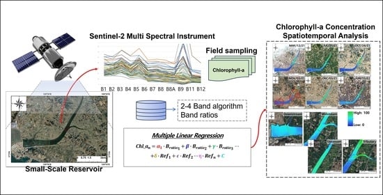
Evaluation of Sentinel-2 Based Chlorophyll-a Estimation in a Small-Scale Reservoir: Assessing Accuracy and Availability

1
Department of Civil, Environmental and Plant Engineering, Graduate School, Konkuk University, Seoul 05029, Republic of Korea
2
Division of Civil and Environmental and Plant Engineering, College of Engineering, Konkuk University, Seoul 05029, Republic of Korea
3
Limnoecological Science Research Institute Korea THE HANGANG, Miryang 50440, Gyeongnam, Republic of Korea
4
Department of Environmental Engineering, College of Engineering, Kangwon National University, Chuncheon 24341, Gangwon-do, Republic of Korea
5
Department of Integrated Energy and Infra System, Kangwon National University, Chuncheon 24341, Gangwon-do, Republic of Korea
6
Rural Research Institute, Korea Rural Community Corporation, Ansan-si 15634, Gyeonggi-do, Republic of Korea
*
Author to whom correspondence should be addressed.
Remote Sens. 2024, 16(2), 315; https://doi.org/10.3390/rs16020315
Submission received: 13 December 2023 / Revised: 9 January 2024 / Accepted: 9 January 2024 / Published: 12 January 2024
(This article belongs to the Special Issue Remote Sensing and GIS in Freshwater Environments)

Abstract

:
Small-scale reservoirs located in river estuaries are a significant water resource supporting agricultural and industrial activities; however, they face annual challenges of eutrophication and algal bloom occurrences due to excessive nutrient accumulation and watershed characteristics. Efficient management of algal blooms necessitates a comprehensive analysis of their spatiotemporal distribution characteristics. Therefore, this study aims to develop a chlorophyll-a (Chl-a) estimation model based on high-resolution satellite remote sensing data from Sentinel-2 multispectral sensors and multiple linear regression. The multiple linear regression (MLR) models were constructed using multiple reflectance-based variables that were collected over 2 years (2021–2022) in an estuarine reservoir. A total of 21 significant input variables were selected by backward elimination from the 2–4 band algorithms as employed in previous Chl-a estimation studies, along with the Sentinel-2 B1-B8A wavelength ratio. The developed algorithm exhibited a coefficient of determination of 0.65. Spatiotemporal variations in Chl-a concentration generated by the algorithm reflected the movement of high Chl-a concentration zones within the body of water. Through this analysis, it turned out that Sentinel-2-based spectral images were applicable to a small-scale reservoir which is relatively long and narrow, and the algorithm estimated changes in concentration levels over the seasons, revealing the dynamic nature of Chl-a distributions. The model developed in this study is expected to support effective algal bloom management and water quality improvement in a small-scale reservoir or similar complex water quality water bodies.

Graphical Abstract

1. Introduction

In order to secure freshwater for agricultural use at the estuary of a river, an estuarine reservoir was formed through the construction of embankment. The development of the estuarine reservoir through estuary segmentation has transformed the water use and material circulation system along the river estuary. Organic matter inflow from the upstream basin may be more likely to accumulate in the reservoir, where it decomposes into inorganic nutrients such as nitrogen and phosphorus. This can lead to eutrophication, a condition in which excessive nutrients in the water stimulate the growth of algae and other aquatic plants [1]. Additionally, various factors such as climate change, urbanization in the upper reaches of rivers, and development activities have led to a diversification of threats to the aquatic environment, further exacerbating the issue of water pollution [2,3]. As a consequence of these problems, there has been a noticeable rise in the occurrence of anomalous algal blooms in small to mid-sized reservoirs. Moreover, the frequency of such events appears to be on a gradual upward trend [4]. To effectively address these issues, it is crucial to have a comprehensive understanding of eutrophication and algal bloom in an entire body of water and to continually monitor these problems [5]. While conventional water quality monitoring in rivers and lakes provides precise, localized measurements at specific times and locations, its single-point nature hinders our ability to grasp the full picture of algal blooms across space and time. This limitation becomes particularly critical when considering the dynamic nature of algal blooms and the need for timely data to inform management decisions. To overcome these shortcomings, remote sensing-based monitoring emerges as a valuable tool.
Chlorophyll-a (Chl-a) is a primary photosynthetic pigment found in plants, microalgae, and bacteria, and is strongly correlated with their biomass and density [6]. Therefore, Chl-a is an important indicator that indirectly estimates the outbreak and density of algae in the water surface [7]. Moreover, Chl-a has characteristic optical properties and is commonly used as a representative factor for detecting algal blooms based on remote sensing (RS) data [8]. Chl-a estimation through remote sensing offers a cost-effective and efficient solution, allowing for monitoring without requiring expensive equipment or time-consuming procedures. It allows for the acquisition of large amounts of spatiotemporal data, enabling comprehensive analysis and understanding of environmental changes. Estimation of Chl-a concentration in oceans typically uses reflectance in the blue and green spectral bands [9]. However, in lakes and rivers, accurate estimates may not be obtained due to optical complexity caused by elements such as colored dissolved organic matter (CDOM), suspended solids, and turbidity, which absorb in the blue spectral region. Therefore, estimates have been made using reflectance in the red (670–700 nm) and near-infrared (700–760 nm) spectral regions, where the interference of CDOM and suspended matter is lower [10].
Various remote sensing studies have been conducted through sensors mounted on aircraft, drones, and satellites. For example, satellite spectral imagery has been widely used to remotely estimate concentration of Chl-a in diverse body of water. However, most past studies have primarily dealt with on large-scale surface waters. The medium resolution imaging spectrometer (MERIS) and moderate resolution imaging spectroradiometer (MODIS), having a coarse spatial resolution (250–1000 m), were used to estimate Chl-a in oceans, bays, and large lakes (2.56–11,601 km2) [11,12,13]. The estimation of Chl-a using sensors such as MODIS and MERIS is challenging for small reservoirs due to the low spatial resolution of these sensors. Landsat 1–7 imagery with spatial resolution ranging from 15 m to 120 m may be used to estimate Chl-a in small inland waterbodies, but it is difficult to apply in complex water quality conditions because of limited radiometric sensitivity [14]. Although Landsat 8 imagery has enhanced radiometric resolution with 12 bits, the relatively long revisit period of 16 days for Landsat 1–8 satellites makes them unsuitable for continuous monitoring of dynamic Chl-a variations in water bodies. The Sentinel-2 MultiSpectral Instrument (MSI) satellite may be an alternative sensor to overcome these limitations and enhance Chl-a estimation capabilities in small reservoirs located in river estuaries. The Sentinel-2 MSI is an advanced sensor offering a short revisit time and higher spatial (10–60 m) and radiometric resolutions (13 bands with 12 bits) [15]. Chegoonian et al. [16] applied Sentinel-2 and Landsat OLI to retrieve Chl-a in Buffalo Pound Lake, which is a small inland reservoir located in the south-central part of Saskatchewan with 30 km2 of water surface area. However, except for Chegoonian et al. [16], there have been very few studies on the application of the Sentinel-2 MSI sensor for estimating Chl-a in a small-scale reservoir with intensive monitoring. When considering the study area and retrieval performance in terms of the size of the water surface area and characteristics of the basin, there may be a distinct difference between Buffalo Pound Lake and an estuarine reservoir in this study. More in-depth studies on the implementation of the Sentinel-2 to a small-scale reservoir are strongly encouraged.
Various datasets from lakes and reservoirs have been compiled, leading to the development and application of Chl-a estimation models using multispectral satellites through different techniques such as semi-empirical models, multiple linear regression (MLR), and machine learning [17,18,19]. Of these, MLR is characterized by its relative simplicity and ease of interpretation. The simplicity of the model allows for an intuitive understanding of the relationships between variables, enabling interpretation of how independent variables influence the dependent variable [20,21]. Previous studies that have developed a Chl-a estimation model in complex aquatic environments have demonstrated enhanced performance by incorporating diverse band ratio combinations [22,23]. Therefore, this study aims to explore the capabilities of Sentinel-2 MSI imagery for Chl-a estimation in a small-scale reservoir using relatively long-term and intensive monitoring datasets.

2. Materials and Methods

Chl-a dynamics in a small-scale reservoir were analyzed by developing a multiple linear regression (MLR) model using Sentinel-2 imagery and on-site water quality data. Field samplings were conducted at three crucial locations in Namyang Reservoir from May 2021 to January 2023. The MLR input variables were constructed using band ratio algorithms in previous studies. Utilizing the developed model, we estimated the spatiotemporal distribution of Chl-a concentrations across the study area (Figure 1).

2.1. Study Area—Namyang Reservoir

The study area, Namyang Reservoir, is located at the border of Hwaseong and Pyeongtaek cities in South Korea. It is an artificial freshwater reservoir created through the construction of embankment. The reservoir has a watershed area of 209 km2, with a maximum river width of 900 m, effective water storage capacity of 20.4 × 10⁶ m3, and a water surface area of 7.67 km2 (Figure 2).
The blockage of the estuary has altered the aquatic environment by causing eutrophication in which organic matter from the upper basin is decomposed into inorganic matter, and inorganic nutrients such as nitrogen and phosphorus are accumulated [24]. In addition, urbanization and industrialization in the surrounding areas pose a risk of water pollution from urban runoff, agriculture, and livestock farming. Consequently, the Namyang Reservoir is confronted with continuous deterioration due to the influx of untreated pollutants, resulting in the decomposition of organic matter and the accumulation of inorganic nutrients like nitrogen and phosphorus. Persistent issues, such as eutrophication and algal blooms, occur within the reservoir. Effective water quality management is essential to ensure the efficient use of this valuable water resource.

2.2. Data Acquisition

A total of 54 field sampling events were conducted from May 2021 to January 2023. These events were undertaken concurrently with image acquisition by Sentinal-2A and 2B, which have a 5-day revisit cycle and capture the Namyang Reservoir at 11:00 AM. The samplings were carried out within approximately 30 min of the satellite visit time. The samplings were mainly conducted at three key locations within the reservoir, the upper, middle, and lower regions, represented by the Namyang-ho, Jang-an, and Namyang Bridges, respectively (see blue, orange, and green dotted boxes in Figure 2). From May to November, some water sampling campaigns were conducted at various points across the reservoir (18–20 locations) to assess the overall Chl-a of the lake. In the field, water quality parameters such as water temperature, dissolved oxygen (DO), conductivity, chlorophyll-a, phycocyanin, and fDOM were measured using a YSI EXO-1 instrument. In the laboratory, total suspended solids (TSS) were measured according to the standard methods [25]. The dissolved organic carbon (DOC) and total nitrogen (TN) were quantified by a total organic carbon (TOC) analyzer (TOC-VCPH, Shimadzu, Kyoto, Japan) equipped with a TN analyzer (TNM-1, Shimadzu, Kyoto, Japan) [26]. Water surface reflectance data for the sampling location were extracted from Sentinel-2 images. In this study, due to the lack of field reflectance data, the atmospherically corrected bottom of atmosphere Level-2A data were used. Level-2A product was processed with Sen2Cor from Copernicus Open Access Hub’s Level-1C (Top of atmosphere) product (https://dataspace.copernicus.eu/browser/, accessed on 8 January 2024). This involved atmospheric correction for Rayleigh scattering, absorption, and scattering effects from gases like ozone, oxygen, and water vapor, as well as the correction of absorption and scattering due to aerosol particles. The reflectance was extracted from the 52SCG tile that includes Namyang Reservoir. Subsequently, the data for each band were resampled to a spatial resolution of 10 m.

2.3. Multiple Linear Regression

To assess the feasibility of applying Sentinel-2 MSI in estimating Chl-a concentration in small reservoirs, the multiple linear regression (MLR) model is applied. MLR is a statistical technique used to analyze the relationship between two or more independent variables and a dependent variable. It allows for the establishment of a mathematical model or approximating function that describes a real-world phenomenon. In general, the relationship between the dependent variable (Y) and the independent variables (X1, X2, …, Xn) is represented by the following equation [21]:
Y = β0 + β1X1 + β2X2 +…+ βnXn
In this equation, β0 is the constant term, and β1, β2,…, βn represent the regression coefficients estimated using the least-squares method. The independent variables (Xn) can be factors such as satellite-based reflectance, and their coefficients indicate the strength and direction of their influence on the dependent variable (Chl-a). It is important to note that MLR assumes linear and additive relationships among the explanatory variables. Despite their simplicity, MLR models have been widely used and have yielded satisfactory results in various studies [27]. To develop the Chl-a estimation model, a random selection of 80% of the data used as the training dataset, with the remaining 20% used as the validation dataset.

2.4. Input Variables

In the process of constructing the input data for the MLR-based Chl-a estimation model, the water surface reflectance at the mean value of the 3 by 3 grid sampling points was used. Subsequently, the extracted reflectance data was used to construct input variables using the 2–4 band algorithms as employed in previous Chl-a estimation studies for different types of water bodies (Table 1) [9,12,28,29]. In addition, the Sentinel-2 B1-B8A wavelength ratio was also included as an input variable in the MLR Band ratios to mitigate the influences of irradiance, atmospheric conditions, and air–water surface effects on reflectance. A ratio-based approach minimizes the confounding factors and enhances the sensitivity to the target variable, leading to improved accuracy in Chl-a estimation [30,31].
To identify the significant input variables, a backward elimination was applied. This method initially includes all candidate variables, then systematically tests each variable for statistical significance. Variables that are found to be statistically insignificant, based on minor significance t values, are sequentially deleted from the model. This process helps refine the MLR model by retaining only the most significant variables [37]. Before variable selection, from the total dataset of 345 data points, points that were influenced by cloud cover were excluded, resulting in a selection of 189 reflectance data points. A total of 88 input variables were constructed based on the 2–4 band algorithms (16 variables) used in previous studies and the B1 to B8A band ratios (72 variables).

2.5. Model Performance Evaluation

The accuracy, bias, and variability performance evaluation of the MLR-based Chl-a estimation model were assessed using coefficient of determination (R2), root mean square error (RMSE), and mean absolute error (MAE) [38,39]. These metrics are calculated as shown in the following equations:
R 2 = 1 S S R S S T = 1 i = 1 n y i y i ^ 2 i = 1 n y i y ¯ 2
R M S E = 1 n i = 1 n y i y i ^ 2
M A E = 10 ( i = 1 n log 10 y i log 10 y i ^ n )
where y i is observed value, y i ^ is estimated value, y ¯ is the averages of the observed values, and n is the total number of values. The R2 provides an indication of the proportion of the variance explained by the model. It ranges from 0 to 1, where a value close to 1 indicates higher model performance, and values higher than 0.5 indicate acceptable performance. The RMSE represents the average error between the predicted and observed Chl-a values, with values closer to 0 indicating a higher accuracy of model [40]. MAE is a suitable accuracy metric for non-Gaussian distribution. Random error serves as a precision estimate, isolating the random variability introduced by measurements and distinguishing it from the overall algorithmic error. It represents the difference between predicted and observed Chl-a averages, and the closer to 1, the lower the error (bias) [39].

3. Results

3.1. Sampling Results

From the field water quality sampling in Namyang Reservoir from 2021 to 2022, the concentration of Chl-a ranged from 9.0 to 127.1 mg/m3, with an average of 23.45 mg/m3, TSS ranged from 3.2 to 135.5 mg/L, with an average of 21.83 mg/L, PC ranged from 1.74 to 14.92 µg/L, with an average of 3.65 µg/L, DOC ranged from 0.4 to 119.5 mg/L, with an average of 3.65 mg/L, fDOM ranged from 3.5 to 80.3 QSU with an average of 48.8 QSU, TN ranged from 0.39 to 9.99 with an average of 3.68 mg/L, and salinity ranged from 0.1 to 1.2 psu, with an average of 0.42 psu (Table 2 and Figure 3). When comparing the water quality data from the three key sampling points, Chl-a concentration decreased from upstream (35.46 mg/L) to downstream (16.93 mg/L), showing a similar trend for other water quality parameters except for salinity.
Pearson correlation analysis was conducted to examine the correlation between Chl-a and other water quality parameters. Except for salinity, the remaining factors demonstrated significant seasonally varying correlations (Table 3).

3.2. Multiple Linear Regression Based Chlorophyll-a Estimation Model

To address the issue of imbalance between low and high Chl-a concentration data, the entire dataset of 189 data points in the MLR model was divided into three concentration ranges: 0–30 mg/m3 (n = 145), 30–50 mg/m3 (n = 24), and 50–130 mg/m3 (n = 20) (Table 4). This division ensured that the training dataset included representative samples from each concentration range, allowing the MLR model to be trained on a balanced set of data.
The 21 variables selected through backward elimination were used to develop the MLR model. The MLR-based Chl-a estimation model is expressed as follows:
C h l o r o p h y l l a m g / m 3 = F ( B 4 / B 3 , B 2 / B 3 , B 5 B 4 + B 6 / 2 , B 8 A / B 7 , ( B 1 1 B 2 1 ) B 3 , B 7 / B 4 , B 6 / B 8 , B 3 / B 4 , ( B 4 1 B 5 1 ) B 3 , B 1 / B 5 , B 5 / B 2 , B 5 / B 3 , B 2 / B 4 , B 8 A / B 3 , B 5 / B 4 , B 7 / B 1 , B 8 A / B 2 , B 5 / B 1 , B 1 / B 4 , B 8 A / B 6 , B 6 / B 5
The performance of the Chl-a estimation model showed an R2 of 0.69 for the training and 0.61 for the test dataset, with an RMSE of 10.73 and 14.49 mg/m3, and MAE of 1.43 and 1.45, respectively. The scatter plot demonstrated a generally linear relationship between the observed and estimated values, indicating that the MLR-based Chl-a estimation performs well across the entire concentration range (Figure 4). Additionally, to further validate the model, spatial Chl-a concentrations were estimated for four separate sampling dates (two dates in 2021 and two dates in 2022) encompassing the entire Namyang Reservoir (Figure 5). These four dates were selected based on comprehensive sampling date conducted across the entirety of Namyang Reservoir. The Chl-a estimation results from all four sampling dates demonstrated clear distribution patterns and high prediction performance (R2: 0.51–0.71, RMSE: 2.60–7.02 mg/m3, MAE: 1.24–1.41) throughout the reservoir.
Among the selected variables, when individually applying the band algorithms used in previous studies, the resulting R2 values were 0.27, 0.06, and 0.13, respectively, indicating significantly reduced predictive performance when used separately (Figure 6).

3.3. Chlorophyll-a Concentration Distribution in Namyang Reservoir

Using the MLR model developed earlier, we estimated the spatial distribution of Chl-a over the research period from May 2021 to December 2022. From a total of 119 Sentinel-2 images, 65 images were selected based on considerations of meteorological conditions and other factors. These selected images were used to generate 69 spatiotemporal Chl-a maps, representing the temporal variation of Chl-a concentrations in Namyang Reservoir based on the selected input variables and the established MLR model (Figure 7 and Figure 8). These Chl-a distribution maps provided valuable insights into the spatial and temporal patterns of Chl-a, even in a small-scale reservoir. Whenever images are obtained from Sentinel-2, the distribution of Chl-a may be estimated whether or not there is field data. High Chl-a concentrations were observed in certain areas, indicating potential hotspots of algal blooms or nutrient enrichment (Figure 9). The Chl-a distribution in Namyang Reservoir exhibited significant variations according to seasons and locations. The average Chl-a concentration in 2021 (24.79 ± 15.26 mg/m3) was higher than in 2022 (16.80 ± 8.06 mg/m3). In both years, Chl-a concentration showed an increasing trend from summer, with a slight decrease in August–September, followed by a period of elevated concentrations until early winter. Furthermore, the distribution patterns varied across different zones, with the upstream and tributary (Z3, Z4 in Figure 9) consistently showing higher Chl-a concentrations compared to the midstream and downstream areas (Z1, Z2 in Figure 9) throughout the study period.

4. Discussion

4.1. Characteristics of Water Quality in Namyang Reservoir

Namyang Reservoir exhibits significant variations in water quality concentrations depending on the season, and the opening or closure of the sluice gates. Additionally, due to the infiltration of seawater, there are significant changes in salinity. In some areas, the reservoir shows characteristics similar to a brackish water ecosystem [41]. Regarding the sampling results based on the locations within the reservoir, Chl-a concentration was highest upstream (Namyang-ho Bridge) (35.46 mg/m3), followed by midstream (Jang-an Bridge) (26.55 mg/m3), and downstream (Namyang Bridge) (16.93 mg/m3), showing an increasing trend towards the upstream. Similar patterns were observed for other water quality parameters (TSS, PC, fDOM) except for DOC and salinity. DOC concentration was highest near the midstream (Jang-an Bridge), while salinity showed higher values closer to the embarkment. From a seasonal perspective, most water quality parameters had an increasing trend from spring to autumn, with a temporary decrease observed during the rainy monsoon season in July and August. A decreasing trend was observed starting from late autumn. However, for Chl-a and PC, high concentrations were observed near the midstream (Jang-an Bridge) in January and February, indicating an anomaly in their seasonal patterns (Appendix A). These variations in water quality can be attributed to the influence of the monsoon climate, which brings heavy rainfall during the summer and dry cold winter, affecting the distribution of Chl-a in the reservoir. The complex water quality conditions in Namyang Reservoir are likely to have influenced the performance of the MLR-based Chl-a estimation model [42]. In the following section, we aim to discuss the impact of the complex water quality conditions on the performance of the model and spatial distribution pattern of Chl-a.

4.2. Selected Input Variables

To accurately estimate Chl-a concentrations in this reservoir, a MLR model was developed, incorporating band algorithms widely employed in previous studies focusing on various freshwater and seawater bodies. The developed MLR model showed the possibility of retrieving Chl-a from complex water quality changes in the Namyang Reservoir. The developed MLR model with the selected 21 input variables demonstrated an average R2 of 0.65 across a wide range of Chl-a concentrations (9.0 to 127.1 mg/m3) and complex water quality conditions. Upon examining the selected input variables, The B5 − ((B4 + B6)/2) band algorithm had a strong correlation with Chl-a concentration in inland lakes and rivers [43]. The ratios B5/B3, B5/B4, and (B4−1 − B5−1)B7 are commonly used in eutrophic lakes dominated by cyanobacteria, and in turbid and productive waters with diverse biophysical and optical characteristics [8,11,44]. Additionally, the ratios B2/B3 and B3/B4 have been applied in studies using coastal monitoring satellites (Sea-WIFS and GOCI) to estimate Chl-a in coastal waters (bays) for monitoring phytoplankton [9,45]. Furthermore, B5-B8A (NIR-red), commonly used for Chl-a estimation in coastal and inland waters, were also selected as input variables for the model. These bands offer advantages in atmospheric correction [46]. In particular, the B5 is widely used as best indicator of phytoplankton biomass, particularly as it falls outside the range provided by Landsat [10,47]

4.3. Performance of the Chlorophyll-a Estimation Model

The performance of the Chl-a estimation MLR model developed using various band algorithms and band ratios for Namyang Reservoir was compared with the Chl-a estimation study conducted for inland lakes and rivers using satellite images. Through this comparison, we evaluated the model’s performance in predicting Chl-a concentrations and how it differs from other existing methods utilized in other water bodies and regions.
Upon reviewing studies that applied band algorithm-based Chl-a estimation to inland water bodies using MODIS and MEIRS data, relatively large water bodies (20–29,743 km2) such as lakes and reservoirs were the main targets. These studies utilized 2–3 band algorithms and showed prediction performance with R2 values ranging from 0.33 to 0.74 [48,49,50]. In the case of Landsat, the studies indicated relatively good performance with R2 values ranging from 0.47 to 0.77. However, due to the absence of spectral data within the 0.70–0.77 nm wavelength range, Landsat may perform less effectively, especially when using the 2–4 band algorithms based on NIR Bands [31,51]. In contrast, a study utilizing Sentinel-2 data by Ansper and Alikas, 2019 [29] investigated various lakes across Europe (0.1–3543.1 km2) and applied 2–4 band algorithms to each lake, demonstrating R2 values ranging from 0.25 to 0.97. They suggested that (B4−1 − B5−1) × B6 and B5 − ((B4 + B6)/2) performed better in lakes with high Chl-a concentrations (~150 mg/m3) and (B4−1 − B5−1)/(B6−1 − B5−1) in lakes with high suspended solids. The low performance observed when applying the band algorithms from previous studies was because of the complex water quality characteristics of Namyang Reservoir (Figure 6). Significant variations in water quality concentrations were evident seasonally, including the continuous influx of untreated pollutants from upstream. Namyang Reservoir has intricate optical properties affected by mixed organic and inorganic particles [52]. In a dynamic environment with significant seasonal variations in concentration (Chl-a: 9.0–127.1 mg/m3, TSS: 3.2–135.5 mg/L), the developed MLR model demonstrated higher performance compared to previous studies, exhibiting robustness to complex water quality changes through its incorporation of the 3–4 band algorithms and band ratios [22,53]. While the MLR model performed well, the growing availability of more sophisticated machine learning algorithms, like random forests, support vector machines, neural networks, and deep learning, suggests that even higher accuracy is possible [54,55]. These models outperform traditional linear regression capabilities in handling complex data patterns and nonlinear relationships. Therefore, future research should investigate into the potential of these advanced techniques for achieving even more accurate chlorophyll-a estimations.

4.4. Driving Factors of Chlorophyll-a Concentration Changes

To address the water quality and algal bloom concerns in Namyang Reservoir, we utilized the MLR model to estimate the spatial distribution changes of Chl-a from 2021 to 2022 and calculated the monthly variations in concentration at key locations (Figure 9). The average Chl-a concentrations at each near key location were found to be 12.42, 17.17, 26.66, and 25.71 mg/m3 at Z1, Z2, Z3, and Z4, respectively. Generally, Chl-a concentration increased from downstream (Z1) to upstream and tributary (Z3 and Z4), which can be attributed to the dilution effect caused by the increase in water depth and the influx of freshwater from small tributaries. Moreover, the settling of suspended particles in the surface as it flows downstream may have contributed to the decrease in Chl-a concentration.
Analysis of overall Chl-a concentration change in Namyang Reservoir from a seasonal perspective showed that the Chl-a concentration tended to increase in spring, reached a first peak in summer, then decreased, and showed a second peak in late autumn. During the summer monsoon season, substantial amounts of TSS, organic matters, and nutrients (nitrogen, phosphorus) were introduced into the reservoir due to rainfall events, which promoted active algal growth [51]. In contrast, the composition of algae in late fall and winter is presumed to be mainly diatoms due to the decrease in temperature. Additionally, stratification in the reservoir caused the upwelling of nutrients from the bottom layer to the water surface, leading to the formation of diatom blooms [56]. These changes in Chl-a are also explained by correlation analysis between seasonal water quality factors and Chl-a (Table 3). TSS showed a high correlation from spring to autumn, and the correlation coefficient (R) ranged from 0.43 to 0.71 (p < 0.001). fDOM showed the high correlation in spring with a R of 0.71 (p < 0.001). It was determined that the influx of TSS and organic matter due to precipitation affect algae growth. In winter, TN showed a high correlation coefficient of 0.864 (p < 0.001), suggesting its significant contribution to algal growth in late autumn and winter, likely associated with the upwelling of organic and inorganic sediments from the bottom layer [24,57]. Examining the influence of water quality factors on reflectance, various wavelength bands such as 440, 550, 665, and 700 nm (B1, B3, B4, B5) were usually used to estimate Chl-a. However, in Case 2 water, these reflectance bands were influenced by various water quality factors. Suspended particulate matter increases reflectance at 739–783 nm (B6, B7) through scattering. Dissolved organic carbon (DOC), fluorescent dissolved organic matter (fDOM), and phytoplankton exhibit light absorption characteristics in the blue wavelength range of 443–492 nm (B1, B2), while phycocyanin (PC) absorbs light in the 600–650 nm range (B4). Consequently, elevated concentrations of these substances in the water impacted Chl-a estimation [46,58,59]. However, despite the reflective impact of these water quality factors, the developed MLR-based Chl-a estimation model demonstrated robust performance, considering combination of various wavelengths and ratios.

5. Conclusions

In this study, we developed an MLR-based Chl-a estimation model for Sentinel-2 multispectral image, considering the complex water quality conditions. By incorporating band ratios and band algorithms utilized in previous studies, the developed MLR model demonstrated relevant performance (R2: 0.65, RMSE: 12.61 mg/m3, MAE: 1.44) in estimating Chl-a concentration across a wide range (9.0 to 127.1 mg/m3), specifically targeting small reservoirs characterized by complex water quality conditions. The MLR model presented here offers valuable insights into the spatial and temporal dynamics of Chl-a concentration in Namyang Reservoir. However, due to the complexity of aquatic environments in Namyang Reservoir, the Chl-a estimation performance is somewhat limited as we solely relied on MLR techniques, band algorithms, and the general atmospheric correction (Sen2Cor) based on reflectance. In future research, a more advanced modeling approach should be explored, incorporating additional environmental factors, and considering advanced models such as random forests and artificial neural networks. Additionally, to achieve more accurate chlorophyll-a estimation, it is essential to consider alternative atmospheric correction techniques (ACOLITE, iCOR, C2RCC) and to develop new atmospheric correction algorithms that can reduce uncertainties [18,60,61]. Furthermore, to enhance accuracy, ongoing water quality parameter monitoring and the continuous integration of Sentinel-2 data are recommended. The practical applications of this research may be to improve analysis of the spatiotemporal distribution of Chl-a, despite the challenges posed by complex water quality conditions in a small-scale reservoir. This study supports improved water quality management and ecological restoration efforts in similar small-scale aquatic ecosystems. By providing a reliable methodology for Chl-a estimation, this study contributes to the broader field of remote sensing and environmental monitoring.

Author Contributions

Methodology, W.J. and Y.P.; writing—original draft preparation, W.J.; conceptualization, Y.P.; data curation, J.-K.S. and K.C.; investigation, J.K. and J.H.K.; validation, S.K.; formal analysis, E.T.K.; supervision and editing, Y.P. and S.K. All authors have read and agreed to the published version of the manuscript.

Funding

This work was supported by the Korea Institute of Planning and Evaluation for Technology in Food, Agriculture, and Forestry (IPET) through the Agricultural Foundation and Disaster Response Technology Development Program, funded by ministry of Agriculture, Food and Rural Affairs (MAFRA) (320049-5). This work was also supported by the Korea Environmental Industry and Technology Institute (KEITI) through the Water Management Program for Drought Project, funded by the Korea Ministry of Environment (MOE) (2022003610002).

Data Availability Statement

The data presented in this study are available on request from the corresponding author. The data are not publicly available due to subject to third party restrictions.

Conflicts of Interest

The authors declare no conflicts of interest.

Appendix A. Detailed Results of Water Quality Parameters for Each Sampling Date During the Study Period

Table A1. Field water quality data in sampling dates of Namyang Reservoir. TSS: total suspended solids, DOC: dissolved organic carbon, fDOM: fluorescent dissolved organic matter, TN: total nitrogen).
Sampling DateChlorophyll-a (mg/m3)TSS (mg/L)Phycocyanin (mg/m3)DOC (mg/L)fDOM (QSU)TN (mg/L)Salinity (psu)
MinMaxMeanMinMaxMeanMinMaxMeanMinMaxMeanMinMaxMeanMinMaxMeanMinMaxMean
12-May-2021 13.6028.4019.87 5.657.296.38 3.914.754.470.30.70.50
22-May-202110.0512.4111.454.4046.5020.172.232.262.245.636.406.10 3.544.013.720.10.70.43
01-Jun-20219.9519.3515.284.4028.4017.072.682.962.865.917.916.69 0.393.492.430.20.60.37
06-Jun-20219.2412.8710.966.4014.4011.201.962.242.066.347.607.05 5.575.925.730.30.60.43
16-Jun-202110.1515.8413.9214.4018.2416.532.142.552.336.4727.5214.14 4.704.824.770.50.50.50
21-Jun-20219.4929.5815.226.4047.5016.592.174.603.366.528.547.32 4.015.244.330.50.50.50
01-Jul-202112.0036.1123.427.2028.8018.133.248.645.978.199.518.65 3.393.743.610.50.60.53
16-Jul-202114.2426.6721.136.4027.3019.103.1310.826.586.838.227.4941.9857.5451.202.563.663.120.30.50.40
21-Jul-202111.5336.0518.524.4065.3021.412.068.444.765.168.086.4650.8260.3157.761.504.562.060.30.50.41
26-Jul-202112.4050.9417.905.6037.6012.442.437.883.555.647.186.563.8361.5755.761.903.132.200.40.50.47
31-Jul-202117.4821.9019.587.2014.4010.802.463.693.117.198.087.6653.6274.1261.321.733.532.340.50.50.50
05-Aug-2021 12.8076.6736.62 6.458.097.32 1.683.562.380.50.60.53
15-Aug-202118.9844.9028.529.6031.6017.872.796.204.156.086.956.5760.0764.1662.561.652.792.160.60.60.60
20-Aug-202115.1443.9121.5113.2036.0020.562.395.823.675.709.466.5655.2263.2259.691.053.391.780.30.60.54
04-Sep-202112.5619.3115.1617.6040.4026.402.072.582.264.065.334.8645.8268.2857.132.234.163.220.20.50.33
09-Sep-202110.5154.3625.5023.2032.4027.801.934.512.903.764.774.4119.7455.8144.112.024.573.260.20.40.30
14-Sep-202112.4363.8924.0111.2047.2023.062.615.483.373.824.634.174.3055.7350.061.893.182.450.30.30.30
24-Sep-202114.5624.0919.6713.2050.0031.332.713.543.023.724.234.0037.9148.5242.532.233.753.080.10.40.27
09-Oct-202112.6521.0516.719.6033.6020.932.352.652.513.924.314.1545.5857.7851.052.266.824.060.40.40.40
14-Oct-202113.2037.2823.659.6048.0025.602.563.823.044.094.434.3046.9349.1647.962.075.633.490.40.40.40
19-Oct-202112.4669.0624.077.6059.6022.642.467.173.454.084.514.3143.4649.2247.362.086.703.130.40.50.42
24-Oct-202114.0322.1519.1014.8023.2018.672.533.533.034.184.734.3840.2646.5644.252.167.304.100.50.50.50
29-Oct-202115.9020.1318.1411.2026.0016.272.573.002.774.314.624.4642.9147.6345.412.448.064.520.40.50.47
13-Nov-202110.0718.2014.9313.6045.2026.532.333.022.734.795.475.2044.4147.9245.932.755.204.060.20.50.30
18-Nov-202110.8119.7115.8218.0025.3721.122.512.932.704.585.284.9845.6048.4146.742.736.944.620.20.50.37
03-Dec-202112.2026.2919.2118.8049.6034.272.753.403.03 37.6044.8941.573.035.594.550.20.50.37
08-Dec-202111.4021.3615.4011.2014.0012.932.653.142.83 43.5345.4144.392.726.144.590.30.50.40
12-Jan-20228.9942.6722.026.0018.0012.132.595.003.423.6013.208.0040.7448.3543.603.769.996.320.50.60.53
27-Jan-202212.4396.5741.766.0016.0010.132.819.315.130.805.203.0739.6151.8444.103.799.156.740.50.60.57
11-Feb-202221.3827.8525.005.2015.2010.133.403.763.641.607.203.7336.2150.6941.523.859.636.370.60.70.63
21-Feb-202212.5441.4322.177.2015.2012.532.854.683.460.406.403.8736.5347.7043.983.899.036.350.50.80.63
08-Mar-202214.6551.1428.5610.0017.2014.673.084.703.674.0010.007.3316.0834.1127.214.238.596.210.60.90.73
28-Mar-202211.7434.7419.8512.0026.4021.472.394.233.096.0018.0012.6731.3445.6640.714.586.365.630.30.80.57
17-Apr-202221.0325.1923.0712.8028.8018.532.763.072.933.608.405.4734.5751.6341.066.298.407.120.60.90.77
02-May-202244.9851.7949.3426.4043.2033.474.265.174.6012.0024.0017.7336.2957.7345.584.325.584.780.60.90.77
12-May-202249.0271.5656.6843.2072.0057.874.346.305.2230.0046.0039.7341.0559.0351.704.416.435.180.70.90.77
17-May-202249.5175.3558.8045.6075.0057.274.316.275.0530.4035.6032.8342.9071.4653.813.866.144.660.810.90
01-Jun-202223.5556.7635.2313.2038.4022.672.986.174.055.2016.4010.0054.3980.2868.003.524.394.070.81.20.97
16-Jun-202220.75127.1159.0211.2034.0022.003.9011.826.545.2016.4010.8061.5978.4367.413.255.854.440.91.21.07
21-Jun-202214.8962.3536.0311.2033.6020.803.648.456.624.0012.407.3369.4178.5072.712.743.613.090.81.21.00
01-Jul-202211.3613.2412.4498.50135.50113.832.123.022.4887.50119.50100.8326.7463.0841.343.425.654.360.10.20.10
21-Jul-202217.2462.7633.2520.0039.2031.202.746.284.7413.2024.0019.6048.4052.6250.482.823.673.200.20.20.20
26-Jul-202212.7346.2327.4214.0077.3340.131.9314.9212.708.8015.3311.5341.3352.9546.742.213.692.750.20.20.20
31-Jul-202210.5360.5332.186.4030.4018.132.896.614.762.8017.6010.2752.4455.0953.952.223.312.660.20.30.23
17-Aug-202210.5820.7015.1715.0057.5044.151.743.332.6712.5042.5035.8838.3646.6540.913.247.294.190.10.20.04
25-Aug-202223.54122.1957.7924.4027.2026.132.788.814.8215.2019.6017.8735.7147.6743.092.764.833.560.10.30.17
13-Sep-202212.3688.4228.136.4028.4011.902.398.013.691.6016.805.5539.9244.9542.673.124.783.740.10.20.11
19-Sep-202215.8739.5026.3912.4036.0024.672.464.543.256.0024.4016.2746.8349.3347.672.684.193.300.10.20.13
29-Sep-202212.1765.7330.658.8027.2015.332.235.213.224.4012.407.2040.4446.2344.222.685.253.540.20.40.27
19-Oct-202210.8946.3521.469.6029.2018.622.335.463.615.6020.0012.686.3753.9744.562.807.923.920.30.40.31
24-Oct-202213.8957.0731.4710.8032.8019.202.335.434.146.0013.608.6740.6048.2645.423.305.324.060.30.30.30
08-Nov-20229.4095.7118.187.2033.6015.142.407.953.190.4010.003.2042.7354.3644.383.727.424.590.40.50.41
23-Nov-20229.6772.1231.653.2032.0016.002.376.153.640.8019.609.623.5357.3544.913.477.434.830.30.40.38
18-Dec-20229.5969.4239.516.0012.009.003.185.944.560.803.602.2045.3050.5647.93 0.50.60.55

References

  1. Lee, Y.G.; Kang, J.H.; Ki, S.J.; Cha, S.M.; Cho, K.H.; Lee, Y.S.; Park, Y.; Lee, S.W.; Kim, J.H. Factors dominating stratification cycle and seasonal water quality variation in a Korean estuarine reservoir. J. Environ. Monit. 2010, 12, 1072–1081. [Google Scholar] [CrossRef] [PubMed]
  2. Griffith, A.W.; Gobler, C.J. Harmful algal blooms: A climate change co-stressor in marine and freshwater ecosystems. Harmful Algae 2020, 91, 101590. [Google Scholar] [CrossRef] [PubMed]
  3. Wurtsbaugh, W.A.; Paerl, H.W.; Dodds, W.K. Nutrients, eutrophication and harmful algal blooms along the freshwater to marine continuum. Wiley Interdiscip. Rev. Water 2019, 6, 1–27. [Google Scholar] [CrossRef]
  4. Foley, B.; Jones, I.D.; Maberly, S.C.; Rippey, B. Long-term changes in oxygen depletion in a small temperate lake: Effects of climate change and eutrophication. Freshw. Biol. 2012, 57, 278–289. [Google Scholar] [CrossRef]
  5. Anderson, D.M. Approaches to monitoring, control and management of harmful algal blooms (HABs). Ocean Coast. Manag. 2009, 52, 342–347. [Google Scholar] [CrossRef]
  6. Moore, T.S.; Dowell, M.D.; Bradt, S.; Ruiz Verdu, A. An optical water type framework for selecting and blending retrievals from bio-optical algorithms in lakes and coastal waters. Remote Sens. Environ. 2014, 143, 97–111. [Google Scholar] [CrossRef]
  7. Cao, Z.; Ma, R.; Duan, H.; Pahlevan, N.; Melack, J.; Shen, M.; Xue, K. A machine learning approach to estimate chlorophyll-a from Landsat-8 measurements in inland lakes. Remote Sens. Environ. 2020, 248, 111974. [Google Scholar] [CrossRef]
  8. Moses, W.J.; Gitelson, A.A.; Berdnikov, S.; Povazhnyy, V. Estimation of chlorophyll-a concentration in case II waters using MODIS and MERIS data—Successes and challenges. Environ. Res. Lett. 2009, 4, 045005. [Google Scholar] [CrossRef]
  9. O’Reilly, J.E.; Maritorena, S.; Mitchell, B.G.; Siegel, D.A.; Carder, K.L.; Garver, S.A.; Kahru, M.; McClain, C. Ocean color chlorophyll algorithms for SeaWiFS. J. Geophys. Res. Ocean. 1998, 103, 24937–24953. [Google Scholar] [CrossRef]
  10. Kallio, K.; Kutser, T.; Hannonen, T.; Koponen, S.; Pulliainen, J.; Vepsäläinen, J.; Pyhälahti, T. Retrieval of water quality from airborne imaging spectrometry of various lake types in different seasons. Sci. Total Environ. 2001, 268, 59–77. [Google Scholar] [CrossRef] [PubMed]
  11. Matthews, M.W.; Bernard, S.; Winter, K. Remote sensing of cyanobacteria-dominant algal blooms and water quality parameters in Zeekoevlei, a small hypertrophic lake, using MERIS. Remote Sens. Environ. 2010, 114, 2070–2087. [Google Scholar] [CrossRef]
  12. Wozniak, M.; Bradtke, K.M.; Krezel, A. Comparison of satellite chlorophyll a algorithms for the Baltic Sea. J. Appl. Remote Sens. 2014, 8, 083605. [Google Scholar] [CrossRef]
  13. Abbas, M.M.; Melesse, A.M.; Scinto, L.J.; Rehage, J.S. Satellite estimation of chlorophyll-a using moderate resolution imaging spectroradiometer (MODIS) sensor in shallow coastal water bodies: Validation and improvement. Water 2019, 11, 1621. [Google Scholar] [CrossRef]
  14. Brezonik, P.; Menken, K.D.; Bauer, M. Landsat-based remote sensing of lake water quality characteristics, including chlorophyll and colored dissolved organic matter (CDOM). Lake Reserv. Manag. 2005, 21, 373–382. [Google Scholar] [CrossRef]
  15. European Space Agency (ESA). SENTINEL-2 User Handbook; ESA: Paris, France, 2015; pp. 1–64. [Google Scholar]
  16. Chegoonian, A.M.; Pahlevan, N.; Zolfaghari, K.; Leavitt, P.R.; Davies, J.M.; Baulch, H.M.; Duguay, C.R. Comparative Analysis of Empirical and Machine Learning Models for Chla Extraction Using Sentinel-2 and Landsat OLI Data: Opportunities, Limitations, and Challenges. Can. J. Remote Sens. 2023, 49, 2215333. [Google Scholar] [CrossRef]
  17. Li, S.; Song, K.; Wang, S.; Liu, G.; Wen, Z.; Shang, Y.; Lyu, L.; Chen, F.; Xu, S.; Tao, H.; et al. Quantification of chlorophyll-a in typical lakes across China using Sentinel-2 MSI imagery with machine learning algorithm. Sci. Total Environ. 2021, 778, 146271. [Google Scholar] [CrossRef]
  18. Chegoonian, A.M.; Zolfaghari, K.; Baulch, H.M.; Duguay, C.R. Support Vector Regression for Chlorophyll-a Estimation Using Sentinel-2 Images in Small Waterbodies. In Proceedings of the 2021 IEEE International Geoscience and Remote Sensing Symposium IGARSS, Brussels, Belgium, 11–16 July 2021; pp. 7449–7452. [Google Scholar] [CrossRef]
  19. Ivanda, A.; Šerić, L.; Bugarić, M.; Braović, M. Mapping chlorophyll-a concentrations in the kaštela bay and brač channel using ridge regression and sentinel-2 satellite images. Electronics 2021, 10, 3004. [Google Scholar] [CrossRef]
  20. Kim, S.W.; Jung, D.; Choung, Y.J. Development of a multiple linear regression model for meteorological drought index estimation based on landsat satellite imagery. Water 2020, 12, 3393. [Google Scholar] [CrossRef]
  21. Prieto, A.J.; Silva, A.; de Brito, J.; Macías-Bernal, J.M.; Alejandre, F.J. Multiple linear regression and fuzzy logic models applied to the functional service life prediction of cultural heritage. J. Cult. Herit. 2017, 27, 20–35. [Google Scholar] [CrossRef]
  22. Matus-Hernández, M.Á.; Hernández-Saavedra, N.Y.; Octavio Martínez-Rincón, R. Predictive performance of regression models to estimate Chlorophyll—A concentration based on Landsat imagery. PLoS ONE 2018, 13, e0205682. [Google Scholar] [CrossRef] [PubMed]
  23. Kim, H.H.; Ko, B.C.; Nam, J.Y. Predicting chlorophyll-a using Landsat 8 OLI sensor data and the non-linear RANSAC method—A case study of Nakdong River, South Korea. Int. J. Remote Sens. 2016, 37, 3255–3271. [Google Scholar] [CrossRef]
  24. Jung, K.W.; Yoon, C.G.; Lee, I.H.; Lee, S.I.; Kang, S.M.; Ham, J.H. Pollutants Release from Sediments in Estuarine Reservoir. J. Korean Soc. Agric. Eng. 2014, 56, 1–9. [Google Scholar] [CrossRef]
  25. American Public Health Association. APHA Standard Methods for the Examination of Water and Wastewater; APHA: Washington, DC, USA, 2005. [Google Scholar]
  26. Lee, Y.G.; Kim, S.; Shin, J.; Rho, H.; Kim, Y.M.; Cho, K.H.; Eom, H.; Oh, S.E.; Cho, J.; Chon, K. Sequential effects of cleaning protocols on desorption of reverse osmosis membrane foulants: Autopsy results from a full-scale desalination plant. Desalination 2021, 500, 114830. [Google Scholar] [CrossRef]
  27. Sousa, S.I.V.; Martins, F.G.; Alvim-Ferraz, M.C.M.; Pereira, M.C. Multiple linear regression and artificial neural networks based on principal components to predict ozone concentrations. Environ. Model. Softw. 2007, 22, 97–103. [Google Scholar] [CrossRef]
  28. Koponen, S.; Attila, J.; Pulliainen, J.; Kallio, K.; Pyhälahti, T.; Lindfors, A.; Rasmus, K.; Hallikainen, M. A case study of airborne and satellite remote sensing of a spring bloom event in the Gulf of Finland. Cont. Shelf Res. 2007, 27, 228–244. [Google Scholar] [CrossRef]
  29. Ansper, A.; Alikas, K. Retrieval of chlorophyll a from Sentinel-2 MSI data for the European Union water framework directive reporting purposes. Remote Sens. 2019, 11, 64. [Google Scholar] [CrossRef]
  30. Dekker, A.G.; Peters, S.W.M. The use of the thematic mapper for the analysis of eutrophic lakes: A case study in the netherlands. Int. J. Remote Sens. 1993, 14, 799–821. [Google Scholar] [CrossRef]
  31. Ha, N.T.T.; Koike, K.; Nhuan, M.T.; Canh, B.D.; Thao, N.T.P.; Parsons, M. Landsat 8/OLI Two bands ratio algorithm for chlorophyll-a concentration mapping in hypertrophic waters: An application to west lake in Hanoi (Vietnam). IEEE J. Sel. Top. Appl. Earth Obs. Remote Sens. 2017, 10, 4919–4929. [Google Scholar] [CrossRef]
  32. Kahru, M.; Mitchell, B.G. Spectral reflectance and absorption of a massive red tide off southern California. J. Geophys. Res. 1998, 103, 21601–21609. [Google Scholar] [CrossRef]
  33. Salem, S.I.; Higa, H.; Kim, H.; Kobayashi, H.; Oki, K.; Oki, T. Assessment of chlorophyll-a algorithms considering different trophic statuses and optimal bands. Sensors 2017, 17, 1746. [Google Scholar] [CrossRef]
  34. Zimba, P.V.; Gitelson, A. Remote estimation of chlorophyll concentration in hyper-eutrophic aquatic systems: Model tuning and accuracy optimization. Aquaculture 2006, 256, 272–286. [Google Scholar] [CrossRef]
  35. Gitelson, A.A.; Gurlin, D.; Moses, W.J.; Barrow, T. A bio-optical algorithm for the remote estimation of the chlorophyll-a concentration in case 2 waters. Environ. Res. Lett. 2009, 4, 2–7. [Google Scholar] [CrossRef]
  36. Zhang, Y.; Ma, R.; Duan, H.; Loiselle, S.; Xu, J. A spectral decomposition algorithm for estimating chlorophyll-a concentrations in Lake Taihu, China. Remote Sens. 2014, 6, 5090–5106. [Google Scholar] [CrossRef]
  37. Telmo, C.; Lousada, J.; Moreira, N. Proximate analysis, backwards stepwise regression between gross calorific value, ultimate and chemical analysis of wood. Bioresour. Technol. 2010, 101, 3808–3815. [Google Scholar] [CrossRef]
  38. Walther, B.A.; Moore, J.L. The concepts of bias, precision and accuracy, and their use in testing the performance of species richness estimators, with a literature review of estimator performance. Ecography 2005, 28, 815–829. [Google Scholar] [CrossRef]
  39. Seegers, B.N.; Stumpf, R.P.; Schaeffer, B.A.; Loftin, K.A.; Werdell, P.J. Performance metrics for the assessment of satellite data products: An ocean color case study. Opt. Express 2018, 26, 7404. [Google Scholar] [CrossRef] [PubMed]
  40. Moriasi, D.N.; Arnold, J.G.; Van Liew, M.W.; Bingner, R.L.; Harmel, R.D.; Veith, T.L. Model evaluation guidelines for systematic quantification of accuracy in watershed simulations. Trans. ASABE 2007, 50, 885–900. [Google Scholar] [CrossRef]
  41. Ueda, S.; Kawabata, H.; Hasegawa, H.; Kondo, K. Characteristics of fluctuations in salinity and water quality in brackish Lake Obuchi. Limnology 2000, 1, 57–62. [Google Scholar] [CrossRef]
  42. Odermatt, D.; Gitelson, A.; Brando, V.E.; Schaepman, M. Review of constituent retrieval in optically deep and complex waters from satellite imagery. Remote Sens. Environ. 2012, 118, 116–126. [Google Scholar] [CrossRef]
  43. Bramich, J.; Bolch, C.J.S.; Fischer, A. Improved red-edge chlorophyll-a detection for Sentinel 2. Ecol. Indic. 2021, 120, 106876. [Google Scholar] [CrossRef]
  44. Gons, H.J.; Rijkeboer, M.; Ruddick, K.G. Effect of a waveband shift on chlorophyll retrieval from MERIS imagery of inland and coastal waters. J. Plankton Res. 2005, 27, 125–127. [Google Scholar] [CrossRef]
  45. Kim, Y.H.; Im, J.; Ha, H.K.; Choi, J.K.; Ha, S. Machine learning approaches to coastal water quality monitoring using GOCI satellite data. GIScience Remote Sens. 2014, 51, 158–174. [Google Scholar] [CrossRef]
  46. Yacobi, Y.Z.; Moses, W.J.; Kaganovsky, S.; Sulimani, B.; Leavitt, B.C.; Gitelson, A.A. NIR-red reflectance-based algorithms for chlorophyll-a estimation in mesotrophic inland and coastal waters: Lake Kinneret case study. Water Res. 2011, 45, 2428–2436. [Google Scholar] [CrossRef]
  47. Hunter, P.D.; Tyler, A.N.; Carvalho, L.; Codd, G.A.; Maberly, S.C. Hyperspectral remote sensing of cyanobacterial pigments as indicators for cell populations and toxins in eutrophic lakes. Remote Sens. Environ. 2010, 114, 2705–2718. [Google Scholar] [CrossRef]
  48. Chavula, G.; Brezonik, P.; Thenkabail, P.; Johnson, T.; Bauer, M. Estimating chlorophyll concentration in Lake Malawi from MODIS satellite imagery. Phys. Chem. Earth 2009, 34, 755–760. [Google Scholar] [CrossRef]
  49. Li, Y.; Wang, Q.; Wu, C.; Zhao, S.; Xu, X.; Wang, Y.; Huang, C. Estimation of chlorophyll a concentration using NIR/Red bands of MERIS and classification procedure in inland turbid water. IEEE Trans. Geosci. Remote Sens. 2012, 50, 988–997. [Google Scholar] [CrossRef]
  50. Odermatt, D.; Giardino, C.; Heege, T. Chlorophyll retrieval with MERIS Case-2-Regional in perialpine lakes. Remote Sens. Environ. 2010, 114, 607–617. [Google Scholar] [CrossRef]
  51. Li, Y.; Zhang, Y.; Shi, K.; Zhou, Y.; Zhang, Y.; Liu, X.; Guo, Y. Spatiotemporal dynamics of chlorophyll-a in a large reservoir as derived from Landsat 8 OLI data: Understanding its driving and restrictive factors. Environ. Sci. Pollut. Res. 2018, 25, 1359–1374. [Google Scholar] [CrossRef]
  52. Han, L.; Rundquist, D.C.; Liu, L.L.; Fraser, R.N.; Schalles, J.F. The spectral responses of algal chlorophyll in water with varying levels of suspended sediment. Int. J. Remote Sens. 1994, 15, 3707–3718. [Google Scholar] [CrossRef]
  53. Patra, P.P.; Dubey, S.K.; Trivedi, R.K.; Sahu, S.K.; Rout, S.K. Estimation of chlorophyll—A concentration and trophic states in Nalban Lake of East Kolkata Wetland, India from Landsat 8 OLI data. Spat. Inf. Res. 2017, 25, 75–87. [Google Scholar] [CrossRef]
  54. Pahlevan, N.; Smith, B.; Schalles, J.; Binding, C.; Cao, Z.; Ma, R.; Alikas, K.; Kangro, K.; Gurlin, D.; Hà, N.; et al. Seamless retrievals of chlorophyll-a from Sentinel-2 (MSI) and Sentinel-3 (OLCI) in inland and coastal waters: A machine-learning approach. Remote Sens. Environ. 2020, 240, 111604. [Google Scholar] [CrossRef]
  55. Yang, W.; Fu, B.; Li, S.; Lao, Z.; Deng, T.; He, W.; He, H.; Chen, Z. Monitoring multi-water quality of internationally important karst wetland through deep learning, multi-sensor and multi-platform remote sensing images: A case study of Guilin, China. Ecol. Indic. 2023, 154, 110755. [Google Scholar] [CrossRef]
  56. Kong, X.; Seewald, M.; Dadi, T.; Friese, K.; Mi, C.; Boehrer, B.; Schultze, M.; Rinke, K.; Shatwell, T. Unravelling winter diatom blooms in temperate lakes using high frequency data and ecological modeling. Water Res. 2021, 190, 116681. [Google Scholar] [CrossRef] [PubMed]
  57. Reiss, R.S.; Lemmin, U.; Cimatoribus, A.A.; Barry, D.A. Wintertime Coastal Upwelling in Lake Geneva: An Efficient Transport Process for Deepwater Renewal in a Large, Deep Lake. J. Geophys. Res. Ocean. 2020, 125, e2020JC016095. [Google Scholar] [CrossRef]
  58. Menken, K.D.; Brezonik, P.L.; Bauer, M.E. Influence of chlorophyll and colored dissolved organic matter (CDOM) on lake reflectance spectra: Implications for measuring lake properties by remote sensing. Lake Reserv. Manag. 2006, 22, 179–190. [Google Scholar] [CrossRef]
  59. Galvao, L.S.; Pereira Filho, W.; Abdon, M.M.; Novo, E.M.M.L.; Silva, J.S.V.; Ponzoni, F.J. Spectral reflectance characterization of shallow lakes from the Brazilian Pantanal wetlands with field and airborne hyperspectral data. Int. J. Remote Sens. 2003, 24, 4093–4112. [Google Scholar] [CrossRef]
  60. Vanhellemont, Q. Adaptation of the dark spectrum fitting atmospheric correction for aquatic applications of the Landsat and Sentinel-2 archives. Remote Sens. Environ. 2019, 225, 175–192. [Google Scholar] [CrossRef]
  61. Grendaitė, D.; Stonevičius, E. Uncertainty of atmospheric correction algorithms for chlorophyll α concentration retrieval in lakes from Sentinel-2 data. Geocarto Int. 2022, 37, 6867–6891. [Google Scholar] [CrossRef]
Figure 1. Study procedure.
Remotesensing 16 00315 g001
Figure 2. Overview of land use, key structures, and sampling points in Namyang Reservoir. The location of key structures such as Namyang, Jang-an, and Namyang-ho Bridge are shown in the figure, along with sampling points indicated by red dots.
Remotesensing 16 00315 g002
Figure 3. Seasonal water quality variation (chlorophyll-a, dissolved organic carbon, total suspended solids, fluorescent dissolved organic matter, phycocyanin, salinity) at three locations (Namyang, Jang-an, and Namyang-ho Bridge).
Remotesensing 16 00315 g003
Figure 4. The scatter plot for the results of the chlorophyll-a estimation using the multiple linear regression model during the training (R2: 0.69, RMSE: 10.73 mg/m3, MAE: 1.43) and test (R2: 0.61, RMSE: 14.49 mg/m3, MAE: 1.45) steps.
Remotesensing 16 00315 g004
Figure 5. Chlorophyll-a (Chl-a) concentration distribution map for performance evaluation of the multiple linear regression based Chl-a estimation model using multi-point sampling dates: R2 0.51 to 0.71, RMSE 2.60 to 7.02 mg/m3, MAE: 1.24 to 1.41. Sampling locations indicated by red circles.
Remotesensing 16 00315 g005
Figure 6. The chlorophyll-a estimation performance of 3–4 band algorithms in isolation for Namyang Reservoir. (a) (B4−1 − B5−1) × B6, (b) B5 − ((B4 + B6)/2), (c) (B4−1 − B5−1)/(B6−1 − B5−1).
Remotesensing 16 00315 g006
Figure 7. Spatiotemporal variation of chlorophyll-a (Chl-a) using multiple linear regression, focusing on dates with high Chl-a concentration observed during May 2021–December 2021.
Remotesensing 16 00315 g007
Figure 8. Spatiotemporal variation of chlorophyll-a (Chl-a) using multiple linear regression, focusing on dates with high Chl-a concentration observed during March 2022–December 2022.
Remotesensing 16 00315 g008
Figure 9. Monthly distribution of chlorophyll-a concentration in Namyang Reservoir: Boxplot analysis across potential hotspots four zone of algal blooms (Z1: Downstream, Z2: Midstream, Z3: Upstream, Z4: Tributary).
Remotesensing 16 00315 g009
Table 1. Investigated band algorithms for chlorophyll-a estimation in various water bodies using different target area and images (satellite, sensors), and an adjusted algorithm with Sentinel-2 band.
Band AlgorithmSentinle-2 BandStudy AreaImageReference
log(R443/R550)log(B1/B3)CoastalSeaWiFS[9]
log(R490/R555)log(B2/B3)
ln(R443/R555)ln(B1/B3)BayGLI satellite[32]
ln(R490/R555)ln(B2/B3)
(R490 − R665)/(R560 − R665)(B2 − B4)/(B3 − B4)SeaMERIS[12]
NDCI (R490, R443)(B2 − B1)/(B2 + B1)BayTriOS-RAMSES
hyperspectral radiometers
[33]
(R443−1 − R490−1) × R560(B1−1 − B2−1) × B3
(R740/R710) − (R740/R650)(B6/B5) − (B6/B4)PondOcean Optics
USB2000 radiometer
[34]
(R665−1 − R705−1) × R740(B4−1 − B5−1) × B6
R667−1 − R710−1B4−1 − B5−1LakeMODIS/MERIS[35]
(R681−1 − R708−1) × R753(B4−1 − B5−1) × B6
(R681−1 − R708−1) × R783(B4−1 − B5−1) × B7LakeMERIS[36]
(R665−1 − R708−1)
/(R753−1 − R708−1)
(B4−1 − B5−1)/
(B6−1 − B5−1)
(R708−1 − R665−1)
/(R560−1 + R510−1)
(B5−1 − B4−1)/
(B31 + B21)
R708/(R490 + R510)B5/(B3 + B4)BayMODIS/MERIS[28]
R704 − ((B665 + 740)/2)B5 − ((B4 + B6)/2)LakeSentinel-2[29]
(R665−1 − R705−1) × R740(B4−1 − B5−1) × B6
(R665−1 − R705−1)
/(R740−1 − R705−1)
(B4−1 − B5−1)
/(B6−1 − B5−1)
Table 2. Descriptive statistics of water quality data in the Namyang Reservoir. SD: standard deviation, TSS: total suspended solids, DOC: dissolved organic carbon, fDOM: fluorescent dissolved organic matter, TN: total nitrogen. P1, P2, and P3 indicate Namyang Bridge, Jang-an Bridge, and Namyang-ho Bridge.
All Samples (n = 345)MinMaxMeanSDMean
P1P2P3
Chlorophyll-a (mg/m3)8.99127.1123.4517.4516.9326.5535.46
TSS (mg/L)3.20135.5021.8315.9417.1422.8232.20
Phycocyanin (mg/m3)1.7414.923.651.612.903.924.58
DOC (mg/L)0.40119.5011.0813.555.205.795.63
fDOM (QSU)3.5380.2848.7810.0914.9014.9716.43
TN (mg/L)0.399.993.681.573.463.725.21
Salinity (psu)0.101.200.420.190.530.440.41
Table 3. Pearson correlation coefficients between chlorophyll-a and water quality parameters TSS: total suspended solids, PC: phycocyanin DOC: dissolved organic carbon, fDOM: fluorescent dissolved organic matter, TN: total nitrogen. Values in parenthesis show the corresponding significance. Asterisks denote statistical significance: p * < 0.05 and p ** < 0.001.
SeasonTSSPCDOCfDOMTNSalinity
SpringChlorophyll-a0.710 **
(p < 0.001)
0.797 **
(p < 0.001)
0.749 **
(p < 0.001)
0.711**
(p < 0.001)
0.038
(p = 0.886)
0.451
(p = 0.069)
Summer0.434 **
(p < 0.001)
0.623 **
(p < 0.001)
0.048
(p = 0.736)
0.305 **
(p < 0.001)
0.181
(p = 0.092)
0.251 *
(p < 0.05)
Autumn0.602 **
(p < 0.001)
0.948 **
(p < 0.001)
0.688 **
(p < 0.001)
−0.038
(p = 0.748)
0.520 **
(p < 0.001)
0.035
(p = 0.765)
Winter0.510
(p = 0.196)
0.994 **
(p < 0.001)
0.577
(p = 0.175)
0.049
(p = 0.909)
0.864 **
(p < 0.001)
−0.045
(p = 0.916)
Table 4. Water quality data for selected 189 points divided into three groups based on chlorophyll-a concentration. TSS: total suspended solids, DOC: dissolved organic carbon, fDOM: fluorescent dissolved organic matter.
Chlorophyll-a (mg/m3)TSS (mg/L)Phycocyanin (mg/m3)DOC (mg/L)fDOM (QSU)
Group 1 (n = 145)Range0.0–30.03.2–98.51.9–10.80.4–87.53.8–69.4
Mean16.015.63.46.250.3
Group 2 (n = 24)Range30.0–50.012.4–45.63.5–14.94.1–30.436.3–70.2
Mean38.626.65.010.750.0
Group 3 (n = 20)Range50.0–130.016.0–74.94.4–11.84.5–35.63.5–80.3
Mean66.434.46.215.151.1
Disclaimer/Publisher’s Note: The statements, opinions and data contained in all publications are solely those of the individual author(s) and contributor(s) and not of MDPI and/or the editor(s). MDPI and/or the editor(s) disclaim responsibility for any injury to people or property resulting from any ideas, methods, instructions or products referred to in the content.

