
Unlocking Urban Accessibility: Proximity Analysis in Bangkok, Thailand’s Mega City


1
Center of Excellence in Urban Mobility Research and Innovation, Faculty of Architecture and Planning, Thammasat University, Pathumthani 12120, Thailand
2
Center for Sustainable Development and Global Smart City, Chubu University, Kasugai 487-8501, Japan
*
Author to whom correspondence should be addressed.
Sustainability 2024, 16(8), 3137; https://doi.org/10.3390/su16083137
Submission received: 28 February 2024
/
Revised: 3 April 2024
/
Accepted: 7 April 2024
/
Published: 9 April 2024
(This article belongs to the Special Issue Research on Sustainable Public Transportation System: Behavior, Safety and Planning)
Abstract
:Accessibility serves as the fundamental link for mode shifts, enabling access to activity areas and facilitating connections to other forms of travel. However, navigating the transportation network in urban areas of Bangkok, Thailand, reveals persistent inconveniences, discomfort, and safety concerns, thereby failing to adequately meet the needs of users. This study aims to examine urban accessibility, focusing on multi-travel connections to amenities and public transport. It focuses on understanding how the level of engagement of road users in social activities contributes to well-being by addressing proximity access through a multidisciplinary approach aimed at enhancing accessibility and integrating the built environment. The comprehensive and inclusive Accessibility by Proximity Index (API) is proposed as a tool to evaluate the level of access to essential services and activities for residents. Additionally, this study acknowledges the impact of the physical and utilization characteristics of urban space and active trajectories by considering various travel needs and daily route patterns. Consequently, the API can inform the development of planning and urban design strategies aimed at enhancing walkability and cycling as non-motorization infrastructures, thereby improving accessibility through active modes of transportation. It was observed that areas with a higher concentration of urban amenities exhibit greater accessibility by walking, cycling, and public transport, particularly in inner-city areas. Thus, envisioning a more sustainable and inclusive city with adequate development of public transportation access is essential in urban areas, prompting policy-level initiatives to enhance the environment and elevate the overall commuting experience.
1. Introduction
The daily commuting challenges in Bangkok and its adjacent areas pose significant hurdles affecting the economic system and the country’s competitiveness. These issues contribute to traffic congestion, which results in air pollution, noise, and a reduced quality of life [1]. The principal cause of these transportation problems originates from the centralized growth pattern of urban centers that lack integrated planning with the transportation system. The problem is likely to become more severe when urban development favors travel by relying on personal vehicles rather than using alternative transportation systems such as walking, cycling, public transit, etc. According to the Global Traffic Scorecard Report 2022, the traffic statistics of Bangkok reveal that it is the second most congested city in Asia [2]. Consequently, there has been an increase in travel demand from various urban areas surrounding Bangkok. Transportation and traffic agencies have endeavored to tackle the travel issues by improving infrastructure to accommodate the city’s growth. This approach seeks to alleviate the problem by augmenting the supply to meet the rising demand [3,4]. However, these plans and projects are often limited in scope to the authority of individual agencies. Consequently, the resolution of traffic issues in Bangkok and its surroundings has yet to integrate comprehensive planning and project information systems [5]. There is a need for an analysis encompassing travel demand management (TDM) operations and the broader development of the traffic network. In order to support the advancement of the public transportation system, the mass rapid transit system, in particular, has been planned to commence operations in 2019 by covering a total distance of 410 km. With further expansions projected to reach 464 km in the next decade [6], there arises a necessity for conducting a comprehensive study aimed at managing travel demand. This involves cohesive collaboration, encompassing the development of traffic networks and public transport systems aligned with anticipated shifts in travel patterns. Such efforts are crucial for fostering efficient investment in infrastructure and ensuring the optimal utilization of traffic networks and public transport systems. However, despite the presence of various types of public transportation systems in Bangkok and its surrounding areas, it has been observed that certain areas still suffer from incomplete service coverage [7]. Many districts lack adequate public transportation services, which contributes to disparities in access to public transportation in these regions [8]. Therefore, reducing reliance on personal vehicles for transportation is key to reducing the amount of road travel that lies at the root of many urban problems. These issues pose significant challenges to solve. Previous studies have attempted to investigate the development of alternative travel modes to promote changes in travel behavior and patterns, which focused on public transportation services in Bangkok, and its vicinities have predominantly focused on behavioral aspects such as travel patterns and vehicle preferences.
While some studies have addressed service provision and direct access to public transportation, they have often highlighted the absence of diverse public transport links within the city’s overall transportation system [9]. Consequently, previous research has tended to examine specific forms of public transport [10]. However, creating sustainability in solving problems should focus on balancing urban development with transportation systems because the design and planning of various activities within cities play an important role in attracting travel demand. These relationships serve as the foundation for addressing other travel-related issues. This presents a significant challenge that requires a thorough understanding to suggest guidelines for promoting urban development that prioritizes alternative transportation systems. There are still research gaps, particularly in countries undergoing urbanization. Accessibility is a commonly utilized factor in assessing the potential and accessibility of activities and services, aiding in appropriate planning and management between transportation systems and activities and services within a city. Enhanced access results in increased life opportunities, as evidenced by various activities and services such as schools, employment, housing, etc. [11]. Specifically, access to urban activities through alternative modes of transportation facilitates the creation of more opportunities for various social interactions or activities while using road access, particularly for people facing travel restrictions, such as those related to income. There are several techniques to consider when measuring accessibility, including time-based, distance-based, and demand-based methods [12]. Understanding accessibility from a spatial perspective is a widely employed principle in transportation research, aiding in the more accurate reflection of development allocations across space. This approach facilitates the examination of service distribution patterns and the varying levels of access to different types, ultimately providing insight into overall accessibility across the region. Furthermore, the engagement of road users in social activities can be reflected through interactions with other commuters, participation in community events along roadways, or engagement in activities accessible via road networks. The sustainable development of such a system necessitates the seamless integration of connections, known as connectivity, with other modes of transportation, encompassing motorized options like personal cars, buses, and passenger boats, as well as non-motorized modes such as bicycles and walking [13]. Accordingly, enhancing access to urban activities through improved transportation options is fundamental for fostering efficient and sustainable urban mobility, thus ensuring that cities remain vibrant, livable, and economically prosperous [14]. Furthermore, the aforementioned engagement influences individuals’ well-being, which encompasses various dimensions such as physical health, mental health, social connections, and overall quality of life. By examining the impact of social activities on well-being, the understanding of how the design and use of roadways can contribute to enhancing people’s overall life satisfaction and happiness. This study aims to evaluate accessibility across various modes of transportation, including walking, cycling, and public transport, focusing on the diverse commuting patterns prevalent in urban areas. By focusing on proximity access, it could allow for understanding how the design and layout of roadways and surrounding built environments influence people’s ability to access these resources conveniently and efficiently. Employing geospatial analysis to assess area accessibility not only serves as a benchmark for evaluating walkability in regional cities but also provides valuable insights to inform the enhancement of pedestrian network infrastructure for relevant agencies.
2. Literature Review
2.1. The Significance of Spatial Accessibility and Urban Activity
Upon reviewing the literature pertaining to accessibility and transportation systems, it became evident that a crucial aspect of studying transportation systems involves considering spatial accessibility [15]. It was noted that the degree of accessibility correlates with travel mode choices and urban activity characteristics. Hence, this section of the literature review aims to emphasize the significance of investigating spatial accessibility and urban activity [16]. The nature of the transportation system evolves over time, shaping the accessibility of urban areas. As the accessibility level of various locations improves, the structure and efficiency of the transportation network influence mobility within the urban community [17]. Enhanced accessibility between areas is observed when the costs associated with movement or travel decrease, encompassing both time and monetary factors. It has been observed that intra-city transportation and area access are interconnected and mutually dependent [18]. The study reveals that accessibility is indispensable for our daily living, as it complexly links with resource acquisition and the facilitation of essential activities, thereby enhancing the quality of life [19]. The capability to access vital resources serves as an assessment of success in accomplishing desired objectives. However, it is important to recognize that not everyone possesses equal abilities in this regard. Disparities arise due to the spatial aspect of access, where proximity plays a key role in which closeness in distance signifies the ease of reaching destinations, thus indicating enhanced accessibility [20]. Conversely, as distance increases, reaching destinations becomes more challenging, posing obstacles to the movement of both people and resources. However, measuring proximity within close distances can be approached from various perspectives. The most widely recognized method is measuring distance on the Earth’s surface, yielding numerical outcomes, typically denoted in units such as kilometers or miles [21]. Additionally, proximity can be evaluated in terms of time or the perceived convenience and familiarity of traveling between locations. Determining proximity and distance through this latter approach involves considering relative or comparative distance. The concept of relative distance offers a broader and more comprehensible understanding of the implications of accessibility on human spatial behavior.
Several studies have demonstrated the potential of applying accessibility analysis to urban activities and services. For instance, in the study conducted by Iamtrakul and Chayphong, which focused on spatial accessibility among rail mass transit and public bus modes in a suburban context, the results indicated differences in the accessibility of city activities and services among the various modes of travel [11]. Yang et al. [22] explored the relationship between accessibility and economic activities from an urban spatial equality perspective. Their findings highlight differences in accessibility to various economic activities in different contexts, particularly when comparing accessibility between urban centers and peripheral suburbs. Additionally, Mitropoulos et al. developed a composite index for assessing accessibility in urban areas by applying and developing two accessibility indices: the infrastructure and the opportunity accessibility index [23]. Their study revealed different levels of accessibility across modes of transport, reaching various opportunities (activities and spaces such as recreational areas, educational facilities, and healthcare buildings).
Several previous studies have emphasized the significance of the local context of each study area, considering the unique placement of activities and services within different areas, as well as the variations in available travel options. These differences may stem from the physical characteristics of development policy areas, which influence the spatial context. This leads to variations in levels of accessibility to activities and services within the city. These challenges highlight research gaps that call attention to the importance of considering the specifics of the local context, rendering the results of other studies not entirely applicable. This emphasizes the need for a conceptual understanding of urban accessibility across various contexts to enhance and develop cities to be more efficient and effective.
2.2. Transport Accessibility Evaluation
The measurement of transportation accessibility has evolved since the 1950s, with a range of indices being employed to measure it based on the specific purpose of measurement and the variables of interest [24]. Previous studies have discussed various methods for measuring accessibility, which can be summarized into four main principles: infrastructure-based, location-based, person-based, and utility-based measures [25]. For instance, Kittelson & Associates [26] have compiled a manual for assessing the capacity and quality of transportation services, which was known as the Transit Capacity and Quality of Service Manual (TCQSM), by focusing on spatial accessibility variables. This manual considers coverage in terms of both distance and time and offers a systematic approach to evaluating the quality of transportation system services by incorporating both spatial and temporal dimensions. In the temporal dimension measurement, the duration spent at transportation service stops is taken into account, while the spatial accessibility assessment considers the coverage area of the public transportation system. This involves generating analytical buffers within a geographic information system. Yang et al. explored the spatial correlation between accessibility to urban vibrancy and time-dynamic accessibility [27]. Similarly, Polzin et al. developed the Time-of-Day-Based Transit Accessibility Analysis Tool, which is a model designed to analyze both spatial and temporal dimensions at the conclusion of the journey [28]. In addition to addressing the supply side of the transportation system, this measure also encompasses the aspect of time demand, accounting for the variation in travel patterns throughout the day. Ryus et al. developed the Transit Level of Service (TLOS), a meticulously personalized accessibility measure that takes into account travel routes and connections between stopping points [29]. Furthermore, it considers population density characteristics and the density of employment sources in the area in conjunction with assessing the level of access to the transportation system. This approach illuminates the dimensions of travel safety and convenience, thereby rendering this method distinctive in measuring public transport accessibility. Moreover, it devises a measurement approach that accounts for both spatial and temporal factors. Another significant metric is the System Access Level Measurement, known as the Public Transportation Accessibility Level (PTAL), which originated in London in 1992. PTAL is based on the density of the public transport network by considering the time required to reach stations and the frequency of public transport services [30].
Overall, location-based accessibility was widely utilized in the present study due to its planning relevance, as well as its ease of interpretability and communicability [31]. The most common measure of location-based accessibility is known as the contour measure (also referred to as the isochronic measure, proximity count, etc.) [25]. This metric is incorporated into the analysis of the Accessibility Index (AI) for all modes available at a given point, a methodology that is currently widely utilized. The research investigates accessibility using various factors and analytical methods, as depicted in Table 1.
3. Methodology
3.1. Study Area
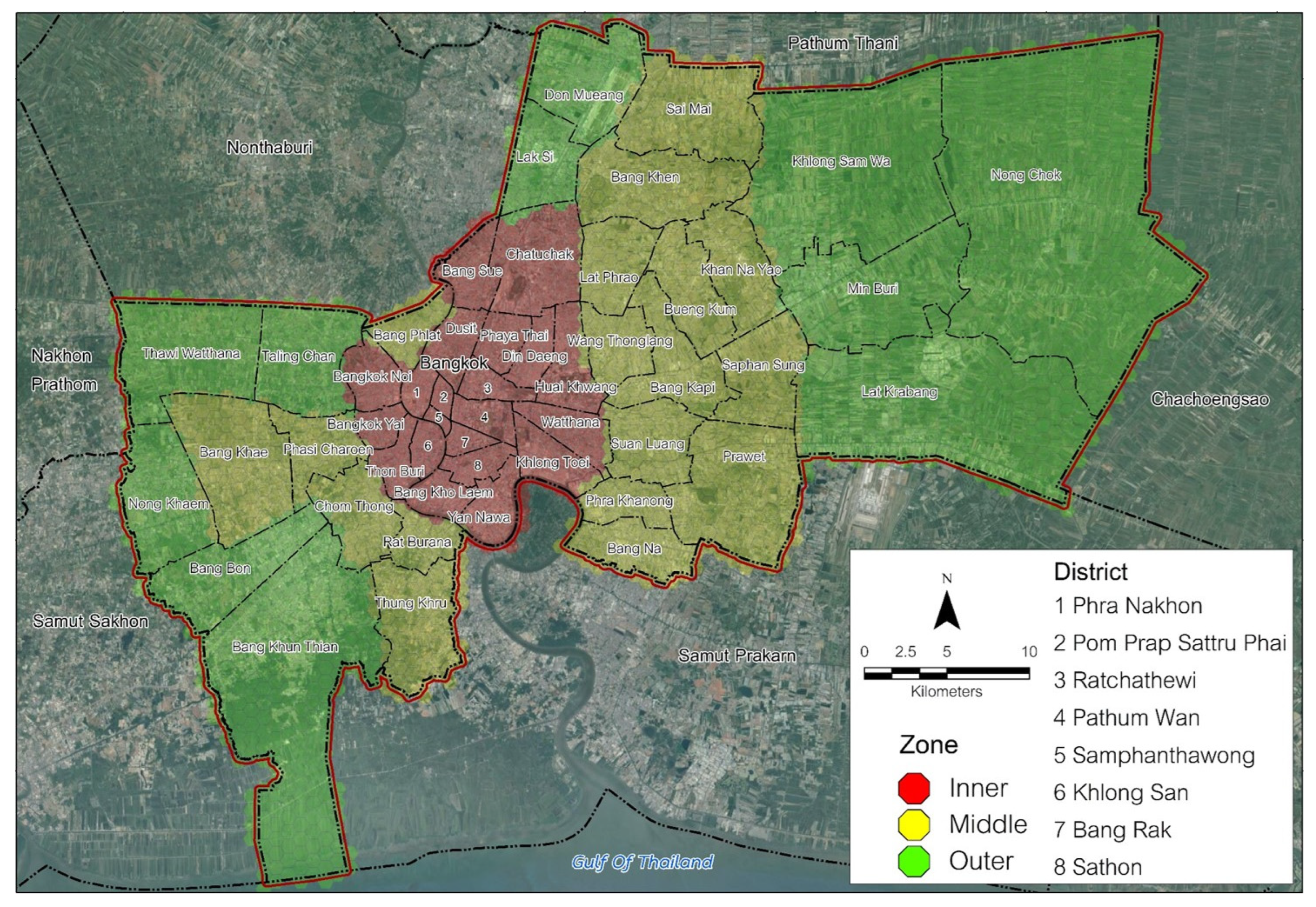
Bangkok, the capital of Thailand, is situated on the lower central plain over the Chao Phraya Delta, near the head of the Gulf of Thailand. It is inhabited by nearly six million registered people, with its influence extending to neighboring provinces that have become closely integrated with Bangkok. Greater Bangkok is estimated to accommodate over 10 million residents engaged in a multitude of daily activities, including work, shopping, recreation, and other pursuits. The city itself spans an area of 1568.73 square kilometers, resulting in a population density of 3690 persons per square kilometer. However, the city has expanded into several surrounding provinces, namely Nonthaburi, Pathum Thani, Samut Prakan, Samut Sakhon, and Nakhon Pathom. Together, these provinces constitute Greater Bangkok or the Bangkok Metropolitan Region, with a population exceeding 15 million, as projected by the National Statistical Office. In this interconnected region, economic and travel activities are deeply intertwined and virtually inseparable. Bangkok, as a study area, reflects the context of the region in two dimensions. Firstly, it is a megacity, and secondly, it is a city still undergoing the process of urbanization, expanding both horizontally and vertically. Moreover, the area is characterized by a diverse range of travel mode options, including walking, bicycles, public buses, rail transport, rail mass transit, and para-transit, including water transport. This diversity helps to illustrate variations in accessibility across different contexts.
Figure 1 provides a visual representation of the study area’s geographical location, explaining the allocation of the inner, middle, and outer zones within the capital city. Additionally, it highlights the distribution of density variations across the urban landscape, encompassing the entirety of the city.
3.2. Datasets
The methodology employed in this study incorporates a comprehensive range of data sources to ensure a holistic understanding of the variety ranges of urban activities. A diverse set of information pertaining to various urban activities, facilities, and services, as elaborated in Table 2, facilitates a spatial exploration of the urban environment, enabling a thorough examination of its complexities and dynamics. In this study, six categories of elements of urban activities and services were considered. (1) Public open spaces: These are public areas where people can engage in activities together, such as parks and playgrounds. (2) Commercial activities and services to the public: This includes commercial and service activities, such as convenience stores, department stores, restaurants, markets, cafes, and hotels/accommodations. (3) Entertainment and sports: This category encompasses entertainment activities and sports facilities. (4) Health and social care: This includes pharmacies, clinics, and hospitals providing healthcare services. (5) Education: This category comprises libraries, schools, high schools, and institutions of higher education. (6) Public transit: This covers infrastructure and facilities related to public transportation, such as bus stops, bus networks, pedestrian pathways, bike lanes, parking areas, and piers. In analyzing access to the Bangkok metropolitan area, all datasets in this research leverage the extensive availability of open-source data, both from OpenStreetMap (OSM) and datasets produced by local authorities, along with the potential for crowdsourcing data within Bangkok. Importantly, OpenStreetMap (OSM) data can be quite accurate and up-to-date [38,39]. However, some studies express concerns about the data quality from OSM due to its vast database of geographic information, which makes it a valuable resource for projects.
Thus, in this study, both OpenStreetMap (OSM) and datasets produced by local authorities were used to validate each other, confirming the accuracy and reliability of the location of urban activities and services, as well as the location and routes of various transportation systems. This enables the collection of highly detailed spatial features concerning the road network and surrounding areas, thereby facilitating the delineation and mapping of all previously listed indicators. Notably, the calculations for Accessibility by Proximity Index (API) necessitate the direct mapping of network indicators onto an accurate digital simulation base structured on a map topology (road graph) comprising lines (roads) and points (intersections). Such detailed characterization of each segment is crucial for objectively observing and experiencing conditions while walking or cycling.
3.3. Process and Data Analysis
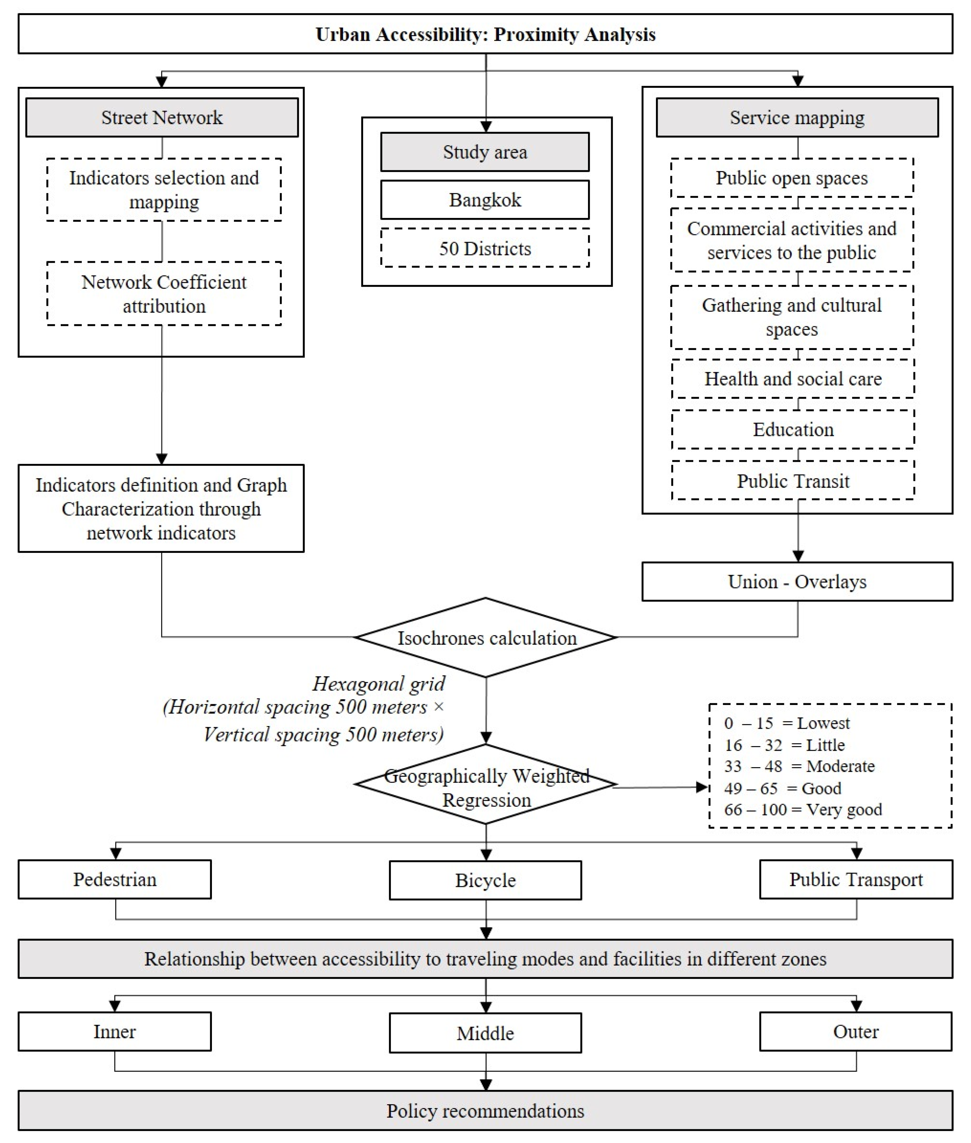
This research employs quantitative methods, specifically for analyzing and comparing data within the framework of quantitative research. This study is divided into three main components (see Figure 2). Firstly, it involves the examination and spatial analysis of three types of public transport networks, which include the road transport network, rail transit network, and water transportation network. Secondly, it involves determining and analyzing the Accessibility by Proximity Index (API). Lastly, the research involves analyzing data to assess the level of public transportation accessibility through Geographic Information Systems (GIS) [40]. Hence, the concept of activity space is employed in the proposed integrated personal accessibility measure, particularly in the creation of a novel index. Analytically, an individual’s “activity space”, denoted as Act space I, is composed of their residential location and daily activities. The size of the activity area is determined using a convex polygon formula [3]. The analysis identifies travel pattern factors, including walking, bicycling, and public transit, such as information on sidewalks, bike lanes, bus stops, and route networks. These factors influence the selection of travel modes and serve as constraints or conditions affecting the accuracy of geographic information systems techniques.
By utilizing spatial tools, this research assesses the potential access to an area through a range of classifications from lowest to very good accessibility (0–100), which assigns scores for the data range (buffer distance/range). Importantly, this research has categorized walking ability values in urban areas into five levels based on the interpretation of accessibility score results, as depicted in Figure 2.
Ari is the area of individual activity space i;
Max Ari is the area of individual activity space i with the bigger polygon in the set of individuals;
Min Ari is the area of individual activity space i with the smaller polygon in the set of individuals.
When this factor approaches a value of one (1), it indicates that the individual’s activity space is small, signifying that their daily activities are closely located relative to their place of residence. Conversely, as the value of the proposed factor approaches zero, the individual’s activity space expands. In the subsequent section, the suggested activity space index is integrated into the new accessibility measure. This recommended measure is thus formulated based on the overarching structure of the composite measure, which combines three new equations encompassing spatial, temporal, and travel elements:
- 1.
- In the first step, accessibility measures must be created for each activity. Equation (2) presents a modified gravity measure that combines two parameters. The first parameter is the spatial component (named SEij), and the second parameter is the travel element (named TrEij) (Equation (2)). To determine the proposed spatial composition of each activity (SEij), this equation incorporates the effect of the factor expressing the importance of activity j (ωij) across all i, weighted by the individual activity space [41].
- SEij: spatial element per daily activity j;
- Actspacei: factor of individual activity space i;
- ωij: factor of importance per activity j for the individual i.
- Equation (3) represents the proposed function of the “Travel Element” per daily activity j. The travel element (TrEij) is a function that encompasses the travel cost. The negative exponential function is commonly utilized to model travel behavior. In this case, the Gaussian type is chosen as the function for the TrEij, as it effectively accounts for the abrupt changes in accessibility levels as an individual moves away from the city center [42]. In Figure 2, travel patterns are divided into three modes based on travel inputs identified in the study area. This includes the format of Non-Motorized Transport (NMT), commonly freely and actively utilized in the study area for sustainable and environmentally friendly transportation. Hence, travel modes are categorized into walking, bicycling, and public transport, as illustrated in Figure 2.
- 2.
- In the second step, integrated accessibility measures must be created for all individual activities on a daily basis. The final form of the proposed composite “accessibility” measure (ACCi) serves as a synthesis of various daily activities. These measures, both fixed and flexible, are exponentially weighted by the temporal component factor (TEij). The suggested temporal component is incorporated into the final measure to reflect participation in each activity on that day. For further analysis, an individual’s engagement in each activity is defined by the total daily hours (hij) spent by person i in activity j. Thus, the temporal component (TEij) is defined according to Equation (4) [5]:
where
- hij is the total individual daily hours for every activity j;
- maxj hij is the maximum time attendance of the total individual activities j.
- Specifically, the proposed composite individual accessibility measure (ACCi) is determined according to the equation below (Equation (5)) [43]:
4. Results
This section introduces a new cumulative opportunity model, incorporating the distribution factor of accessible opportunities and the factor of the analysis of the connectivity, as illustrated in Table 3.
In the analysis of public transportation accessibility in Bangkok, this study aims to assess the level of access across various modes of transportation and to discern spatial patterns. Based on the analysis of the sub-factors outlined in Table 3 and their integration into a hexagonal grid with a horizontal and vertical spacing of 500 m, encompassing a total of 6 main factors and 19 sub-factors, it was observed that areas with a concentration of these factors are primarily located within inner Bangkok. This aspect of the analysis aims to evaluate the level of accessibility to diverse urban activities, categorized by modes of travel, which are walking, cycling, and public transportation, thereby accounting for disparities in accessibility across different transportation networks.
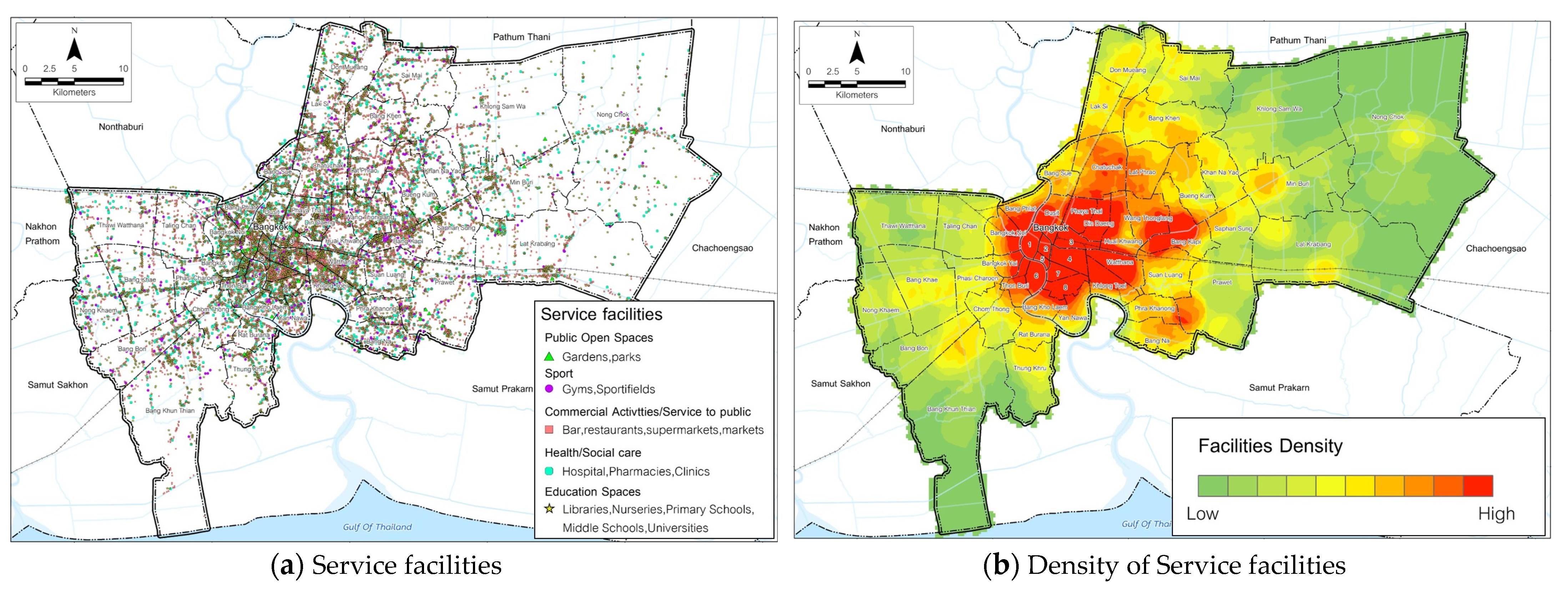
Figure 3 depicts service facilities in the Bangkok area, revealing a concentration of such facilities in the inner Bangkok area. This region encompasses Phra Nakhon, Pom Prap Sattru Phai, Ratchathewi, Pathum Wan, Samphanthawong, Khlong San, Bang Rak, Sathon, Phaya Thai, Dindaeng, and Watthana, showcasing a dense cluster of facilities and characterized by workplaces, commercial establishments, and educational institutions, easily accessible via various modes of transportation. In the analysis of accessibility across different modes, as depicted in Figure 4, it was observed that within the study area, spatial analysis of the transportation route network plays a crucial role. This infrastructure fosters travel opportunities and spatial accessibility for urban residents. Essentially, the transportation network serves as the significant interconnector of various parts of the city.
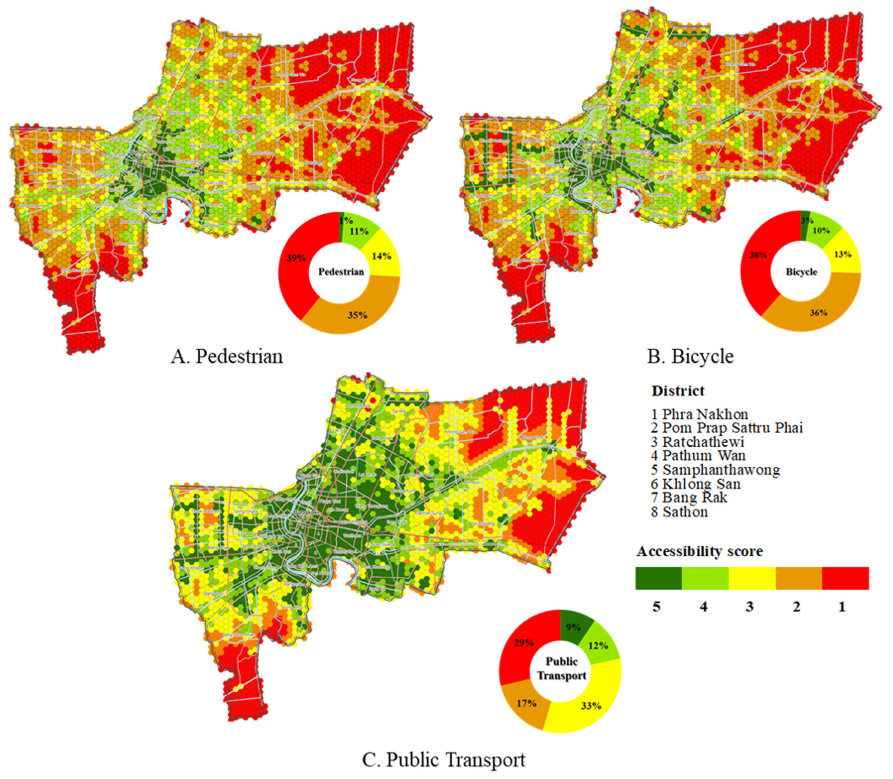
However, access to certain areas may be limited if there are no pathways linking them, whether for short-distance travel on foot, cycling, or utilizing the city’s public transportation system [6]. Moreover, the distribution characteristics of the data were taken into account. By assessing the distribution via standard deviation (SD) and comparatively considering the coefficient of variation, it was observed that the dataset pertaining to the level of access to public transportation systems exhibited a coefficient of variation of 42.20 percent (SD = 2.65, Mean = 5.65). Following this, data related to cycling displayed a coefficient of variation of 53.15 percent (SD = 1.47, Mean = 2.64), while pedestrian walkways demonstrated a coefficient of variation of 152.27 percent (SD = 1.89, Mean = 1.10). The findings, as illustrated in Table 4, indicate that the dataset concerning public transport access levels exhibits the highest clustering, followed by cycling paths and, finally, pedestrian walkways, which display the highest dispersion coefficient. This underlines a significant disparity in the level of access to public transport within the area. The distribution coefficients calculated from the aforementioned datasets on accessibility levels for various modes of transportation also carry spatial implications, indicating the spatial disparities in public transport access levels. Specifically, lower distribution coefficients suggest that access levels to public transport within each area are clustered together, implying minimal variation across the region.
From Table 5, it is evident that the values for all six groups of urban activities, public open spaces, commercial activities, entertainment, health education, and public transit, are statistically significant at 0.000 level. This indicates that accessibility to all types of activities has an impact on all modes of travel. Specifically, the results suggest that commercial activities exhibit the highest concentration, while public open spaces have the lowest concentration. In other words, commercial activities are more densely distributed across the urban landscape compared to public open spaces. This information draws attention to the interconnectedness between various urban activities and their influence on travel patterns within the study area. Furthermore, considering the overall accessibility in Table 5 allows us to observe the relationship between the level of accessibility and different groups of urban activities.
Additionally, it was observed that areas with high accessibility levels for public transport predominantly cover the eastern side of the Chao Phraya River. When considering the overall accessibility landscape, it becomes evident that upon dividing areas based on accessibility characteristics and population concentration, the distribution of public transport access levels remains consistent. The highest average access levels are concentrated in inner-city areas, gradually decreasing with distance from the city center. Public transport access is rated on a scale from level 0 to level 5 with the following details: (1) areas at level 1 comprise inner-city areas with historical significance, (2) areas at level 2 encompass inner-city areas on the Thonburi side, (3) level 3 includes middle-class urban areas on the eastern side, (4) level 4 encompasses middle-class urban areas on the western side, and (5) the lowest level consists of suburban areas outside Bangkok. Based on Table 6, it can be inferred that accessibility levels 1 to 2 denote very good accessibility across pedestrian, bicycle, and public transport modes. When exploring the relationship with population concentration, it becomes apparent that convenient travel patterns, characterized by easy access and convenience, are closely linked to population density. Urban areas, serving as both residential and employment hubs, benefit from convenient transportation options, thus effectively meeting the diverse travel needs of the population, including recreational outings and commuting to work within urban settings.
5. Discussion
This study focuses on understanding urban accessibility to all urban activities and services in different contexts and modes of travel. The research question is whether each area has different accessibility to urban activities and services and whether every area has access to all forms of transportation. Accessibility is considered a key attribute of cities and plays a significant role in promoting equity and quality of life. The location-based accessibility approach is advantageous as it reflects the spatial distribution of accessibility levels, which enhances relevance and ease of interpretability and communicability [31]. Incorporating this approach in the determination of Accessibility by Proximity Index (API) has great potential in analyzing the spatial pattern of accessibility. The study results demonstrate the measurement of the different levels of access among all three modes of travel (walking, cycling, and public transport) and reveal that areas with convenient access to all three transportation modes are predominantly concentrated within inner Bangkok. Corresponding to Yang et al., the results indicate that there is a high level of accessibility to economic activities within central cities and a decrease in accessibility in more remote areas, especially in peripheral suburbs [22]. Likewise, Guo et al. measure accessibility to social infrastructures in urban–rural areas based on an inequality perspective [42]. The study highlights differences in spatial access, indicating that urban areas have greater accessibility to social infrastructures compared to rural areas. Additionally, it illustrates the level of accessibility to different activities in each group, and the travel patterns are consistent with the findings of the study. In Mitropoulos et al. [23], the results indicate different levels of accessibility across modes of transport, including different activities. When considering travel patterns, it can be observed that in urban areas or areas with a high density of city activities and services, there are a variety of travel mode options compared to distant areas or areas with low density [11]. This highlights spatial disparities and inequalities in travel access across the study area.
Bangkok’s urban expansion pattern typically aligns with main roads and clusters around public rail transport stations. Furthermore, numerous studies have highlighted the correlation between land use patterns, including land prices, and the presence of a public rail transport network. The proposed accessibility measures introduce a novel aspect of personal accessibility, aiming to complement modern accessibility metrics. This research revealed that the concentration of urban amenities influences pedestrian, bicycle, and public transport travel. It is evident that all three modes of travel exhibit a high concentration of urban amenities in the inner city. They integrate spatial, travel, and temporal elements with conventional measurement methods. The advantage of these recommended measurements lies in their simplicity, which does not necessitate complex calculations and is grounded in easily comprehensible theory [5]. The proposed accessibility measure represents a composite metric incorporating the impact of activity space and temporal constraints on accessibility measures. Particularly, an individual’s total outdoor activity in a day is considered in this new measure, which aims to assess an individual’s overall access during a typical day. Proximity access refers to the ease with which individuals can access essential services, amenities, and social opportunities in their immediate surroundings. This could include access to schools, healthcare facilities, recreational areas, shops, and social gathering places. The recommended accessibility measures will establish the groundwork for understanding the relationship between accessibility measures and activity space [6]. Given the complex nature of the interactions between road use, social activities, and well-being, perspectives from various fields can be integrated, such as transportation planning, urban design, public health, psychology, sociology, and geography. This interdisciplinary approach allows for a more comprehensive understanding of the topic and enables us to explore various facets of the relationship between road use, social engagement, and well-being. This aspect highlights the ultimate goal of the research, which is to inform strategies and interventions aimed at improving the design and functionality of roadways and the surrounding built environment to promote better accessibility and well-being. This could involve recommendations for urban planning policies, infrastructure improvements, community engagement initiatives, or public health interventions designed to create environments that support social interaction, physical activity, and overall well-being among road users.
From Table 5, it can be implied that the relationship between city facilities and all six groups of urban activities exists among public open spaces, commercial activities and services to the public, entertainment and sports, health and social care, and education. The data clearly indicate that access to public transport is most prevalent in urban areas compared to others, which correlates with the abundance of facilities and amenities. The transportation infrastructure appears to be concentrated in the inner-city region, offering superior service. Based on the statistical analysis, it is evident that the R2 value exceeds 0.5, suggesting that the concentration of urban amenities influences the selection of travel modes, including walking, cycling, and public transport usage. Upon examining the relationship between these three modes and the number of facilities across the urban areas (inner, middle, and outer), it was observed that individuals residing in urban settings tend to select walking when amenities are highly concentrated, particularly in the inner region. Conversely, in the middle and outer areas where amenities are distributed, people tend to favor bicycles and public transport based on travel distance and convenience.
6. Conclusions
This approach offers insights into the scale of activity space concerning the accessibility of each context. These findings can serve as valuable information for informing and guiding initial policy recommendations. In transportation planning and the development of future public transport systems or related policies, it is crucial to prioritize the consideration and awareness of spatial inequalities in access to public transport systems. To enhance the effectiveness of city planning measures, the transportation network, particularly public rail, should serve as a guiding tool for urban development planning. This approach is preferable to relying solely on legal enforcement or control measures, which can be more challenging to implement. In this study, the focus is on place accessibility. In the future, it will be interesting to explore this relationship across different socioeconomic groups as people accessibility. Activity spaces hold promise as a widely utilized tool for investigating spatial accessibility in transportation policy and planning. Ultimately, the proposed integrated individual accessibility measure introduces a novel assessment tool in the realm of spatial mobility planning, for the reason that it serves as an indicator of quality of life, which offers valuable insights into social and spatial equity in urban services. In summary, the concept and measurement of active and transit accessibility have been thoroughly explored in the literature. A broad array of technical approaches has been proposed to comprehensively capture the interactions between people and opportunities facilitated by the transport system. Consequently, there is an increased demand for high-resolution data and enhanced computational capacity. The underlying concept has significantly evolved beyond simple spatial analysis to incorporate non-spatial, contextual aspects of mobility, including individual and temporal components. Nevertheless, the primary determinant of accessibility remains the quantity of accessible opportunities. Evaluating the spatial performance of a transit network has long been a concern for transit agencies and planners. However, the existing literature largely overlooks the spatial distribution of accessible opportunities within the current network and service design, which serves as a crucial indicator of spatial performance.
Author Contributions
Conceptualization, P.I.; Methodology, P.I.; Validation, S.C.; Formal Analysis, P.I. and S.C.; Investigation, S.C.; Data Curation, S.C.; Writing—Original Draft, P.I., A.P. and S.C.; Writing—Review and Editing, P.I., A.P., S.C. and Y.H.; Visualization, S.C.; Supervision, P.I. and Y.H.; Project Administration, P.I.; Funding Acquisition, P.I. All authors have read and agreed to the published version of the manuscript.
Funding
This research was funded by the Science and Technology Research Partnership for Sustainable Development (SATREPS), the Japan Science and Technology Agency (JST)/Japan International Cooperation Agency (JICA) under Grant JPMJSA1704, the Japan Society for the Promotion of Science (JSPS) Grant-in-Aid for Scientific Research (C) (20K11873), and the Chubu University Grant.
Institutional Review Board Statement
Not applicable.
Informed Consent Statement
Not applicable.
Data Availability Statement
Data are contained within the article.
Acknowledgments
The research was conducted by the Center of Excellence in Urban Mobility Research and Innovation (UMRI), Thammasat University, Pathumthani, Thailand.
Conflicts of Interest
The authors declare no conflicts of interest.
References
- National Oceanic and Atmospheric Administration. Version 4 DMSP-OLS Nighttime Lights Time Series [Database]. 2019. Available online: https://www.ngdc.noaa.gov/eog/dmsp/downloadV4composites.html (accessed on 30 October 2023).
- INRIX. Global Traffic Scorecard. 2022. Available online: https://inrix.com/scorecard/ (accessed on 30 October 2023).
- Yan, X.-Y.; Wang, W.-X.; Gao, Z.-Y.; Lai, Y.-C. Universal model of individual and population mobility on diverse spatial scales. Nat. Commun. 2017, 8, 1639. [Google Scholar] [CrossRef] [PubMed]
- United Nations, Department of Economic and Social Affairs, Population Division. World Urbanization Prospects: The 2022 Revision (ST/ESA/SER.A/420); United Nations: New York, NY, USA, 2023; Available online: https://population.un.org/wup/ (accessed on 30 October 2023).
- Cai, J.; Huang, C.; Deng, Z.; Li, L. Transport accessibility and poverty alleviation in Guizhou Province of China: Spatiotemporal pattern and impact analysis. Sustainability 2023, 15, 3143. [Google Scholar] [CrossRef]
- Santos, T.; Ramalhete, F.; Julião, R.P.; Soares, N.P. Sustainable living neighbourhoods: Measuring public space quality and walking environment in Lisbon. Geogr. Sustain. 2022, 3, 289–298. [Google Scholar] [CrossRef]
- Marquet, O.; Miralles-Guasch, C. The Walkable city and the importance of the proximity environments for Barcelona’s everyday mobility. Cities 2015, 42, 258–266. [Google Scholar] [CrossRef]
- Capasso da Silva, D.; King, D.A.; Lemar, S. Accessibility in practice: 20-minute city as a sustainability planning goal. Sustainability 2020, 12, 129. [Google Scholar] [CrossRef]
- Delclòs-Alió, X.; Miralles-Guasch, C. Looking at Barcelona through Jane Jacobs’s eyes: Mapping the basic conditions for urban vitality in a Mediterranean conurbation. Land Use Policy 2018, 75, 505–517. [Google Scholar] [CrossRef]
- Abdelfattah, L.; Boni, G.; Carnevalini, G.; Choubassi, R.; Gorrini, A.; Messa, F.; Presicce, D. A user-centric approach to the 15-minute city. Examining children’s walkability in Bologna. In Proceedings of the 57th ISOCARP World Planning Congress (ISOCARP 2021), Doha, Qatar, 8–11 November 2021; pp. 582–591. [Google Scholar]
- Iamtrakul, P.; Chayphong, S. Exploring Spatial Accessibility to Urban Activities Based on the Transit-Oriented Development Concept in Pathum Thani, Thailand. Sustainability 2024, 16, 2195. [Google Scholar] [CrossRef]
- Ferreira, A.; Batey, P. Re-Thinking Accessibility Planning: A Multi-Layer Conceptual Framework and Its Policy Implications. Town Plan. Rev. 2007, 78, 429–458. [Google Scholar] [CrossRef]
- Appleyard, B. New methods to measure the built environment for human-scale travel research: Individual access corridor (IAC) analytics to better understand sustainable active travel choices. J. Transp. Land Use 2015, 9, 121–145. [Google Scholar] [CrossRef]
- Arellana, J.; Saltarín, M.; Larranaga, A.M.; Gonzalez, V.B.; Henao, C.A. Developing an urban bikeability index for different types of cyclists as a tool to prioritise bicycle infrastructure investments. Transp. Res. A Policy Pract. 2020, 139, 310–334. [Google Scholar] [CrossRef]
- Caiello, S.; Bottini, L. Walkability and soft mobility propensity: A research on two Italian urban neighbourhoods. Appl. Mobilities 2022, 7, 107–123. [Google Scholar] [CrossRef]
- Campisi, T.; Ignaccolo, M.; Inturri, G.; Tesoriere, G.; Torrisi, V. Evaluation of walkability and mobility requirements of visually impaired people in urban spaces. Res. Transp. Bus. Manag. 2021, 40, 100592. [Google Scholar] [CrossRef]
- Clifton, K.J.; Livi Smith, A.D.; Rodriguez, D. The development and testing of an audit for the pedestrian environment. Landsc. Urban Plan. 2007, 80, 95–110. [Google Scholar] [CrossRef]
- Currie, G.; Delbosc, A. Modelling the social and psychological impacts of transport disadvantage. Transportation 2010, 37, 953–966. [Google Scholar] [CrossRef]
- Ferreira, A.; Bertolini, L.; Næss, P. Immobility as resilience A key consideration for transport policy and research. Appl. Mobilities 2017, 2, 16–31. [Google Scholar] [CrossRef]
- Gaglione, F.; Gargiulo, C.; Zucaro, F. Where can the elderly walk A spatial multi-criteria method to increase urban pedestrian accessibility. Cities 2022, 127, 103724. [Google Scholar] [CrossRef]
- Kenyon, A.P.; Pearce, J. The socio-spatial distribution of walkable environments in urban Scotland: A case study from Glasgow and Edinburgh. SSM Popul. Health 2019, 9, 10046. [Google Scholar] [CrossRef] [PubMed]
- Yang, X.; Niu, F.; Sun, D. Evaluation of Urban Spatial Equality Based on Accessibility to Economic Activities: Beijing as a Case Study. Complexity 2020, 2020, 4560146. [Google Scholar] [CrossRef]
- Mitropoulos, L.; Karolemeas, C.; Tsigdinos, S.; Vassi, A.; Bakogiannis, E. A composite index for assessing accessibility in urban areas: A case study in Central Athens, Greece. J. Transp. Geogr. 2023, 108, 103566. [Google Scholar] [CrossRef]
- Hansen, W.G. How Accessibility Shapes Land Use. J. Am. Inst. Plan. 1959, 25, 73–76. [Google Scholar] [CrossRef]
- Geurs, K.T.; van Wee, B. Accessibility evaluation of land-use and transport strategies: Review and research directions. J. Transp. Geogr. 2004, 12, 127–140. [Google Scholar] [CrossRef]
- Kittelson & Associates, Inc. Transit Capacity and Quality of Service Manual, 2nd ed.; TCRP Project 100; TRB, National Research Council: Washington, DC, USA, 2003; Available online: https://onlinepubs.trb.org/onlinepubs/tcrp/docs/tcrp100/Part3.pdf (accessed on 30 October 2023).
- Yang, L.; Zhang, B.; Zhang, X.; Zhang, S.; Yin, L. Exploring the spatial correlation between accessibility to urban vibrancy centers and housing price from a time-dynamic perspective. GIScience Remote Sens. 2023, 60, 2232191. [Google Scholar] [CrossRef]
- Polzin, S.E.; Pendyala, R.M.; Navari, S. Development of time-of-day-based transit accessibility analysis tool. Transp. Res. Rec. J. Transp. Res. Board 2002, 1799, 35–41. [Google Scholar] [CrossRef]
- Ryus, P.; Ausman, J.; Teaf, D. Development of Florida’s transit level-of-service indicator. Transp. Res. Rec. J. Transp. Res. Board 2000, 1731, 123–129. [Google Scholar] [CrossRef]
- Transport for London. Assessing Public Transport Accessibility Level in London (PTAL). 2020. Available online: http://content.tfl.gov.uk/connectivity-assessment-guide.pdf (accessed on 2 February 2024).
- Su, R.; Goulias, K. Untangling the relationships among residential environment, destination choice, and daily walk accessibility. J. Transp. Geogr. 2023, 109, 103595. [Google Scholar] [CrossRef]
- Bernardi, S.; La Paix-Puello, L.; Geurs, K. Modelling route choice of Dutch cyclists using smartphone data. J. Transp. Land Use 2018, 11, 883–900. [Google Scholar] [CrossRef]
- Boulange, C.; Gunn, L.; Giles-Corti, B.; Mavoa, S.; Pettit, C.; Badland, H. Examining associations between urban design attributes and transport mode choice for walking, cycling, public transport and private motor vehicle trips. J. Transp. Health 2017, 6, 155–166. [Google Scholar] [CrossRef]
- Ferrer-Ortiz, C.; Marquet, O.; Mojica, L.; Vich, G. Barcelona under the 15-minute city lens: Mapping the accessibility and proximity potential based on pedestrian travel times. Smart Cities 2022, 5, 146–161. [Google Scholar] [CrossRef]
- Gao, J.; Kamphuis, C.B.M.; Helbich, M.; Ettema, D. What is ‘neighborhood walkability’? How the built environment differently correlates with walking for different purposes and with walking on weekdays and weekends. J. Transp. Geogr. 2020, 88, 102860. [Google Scholar] [CrossRef]
- Vale, D.S.; Saraiva, M.; Pereira, M. Active accessibility: A review of operational measures of walking and cycling accessibility. J. Transp. Land Use 2016, 9, 209–235. [Google Scholar] [CrossRef]
- Wang, F.; Wang, K. Measuring spatial accessibility to ecological recreation spaces in the Pearl River delta region: An improved two-step floating catchment area method. J. Spat. Sci. 2018, 63, 279–295. [Google Scholar] [CrossRef]
- EI-Ashmawy, K. Testing the positional accuracy of OpenStreetMap data for mapping applications. Geod. Cartogr. 2016, 42, 25–30. [Google Scholar] [CrossRef]
- Zheng, S.; Zheng, J. Assessing the Completeness and Positional Accuracy of OpenStreetMap in China. In Thematic Cartography for the Society; Bandrova, T., Konecny, M., Zlatanova, S., Eds.; Lecture Notes in Geoinformation and Cartography; Springer: Cham, Switzerland, 2014. [Google Scholar] [CrossRef]
- Wang, J.; Kwan, M.-P.; Cao, W.; Gong, Y.; Guo, L.; Liu, Y. Assessing changes in job accessibility and commuting time under bike-sharing scenarios. Transp. A Transp. 2022, 20, 36. [Google Scholar] [CrossRef]
- Guo, C.; Zhou, W.; Jing, C.; Zhaxi, D. Mapping and measuring urban-rural inequalities in accessibility to social infrastructures. Geogr. Sustain. 2024, 5, 41–51. [Google Scholar] [CrossRef]
- Xie, S.; Liu, S.; Li, Q. Availability of Infrastructure and Rural Poverty Reduction: Empirical Analysis from Micro data in China. Chin. Rural Econ. 2018, 5, 112–131. [Google Scholar]
- Basu, T.; Das, A.; Pereira, P. Exploring the drivers of urban expansion in a medium-class urban agglomeration in India using the remote sensing techniques and geographically weighted models. Geogr. Sustain. 2023, 4, 150–160. [Google Scholar] [CrossRef]
Figure 1.
Study area: Bangkok metropolitan area.

Figure 2.
The analysis process.

Figure 3.
Service facilities and density mapping in the study area.

Figure 4.
Spatial distribution of accessibility: (A) pedestrian accessibility; (B) bicycle accessibility; (C) public transport accessibility.
Figure 4.
Spatial distribution of accessibility: (A) pedestrian accessibility; (B) bicycle accessibility; (C) public transport accessibility.


Table 1.
Indicators in accessibility analysis.
| Services | Use | Source |
|---|---|---|
| Categories: Living, Working, Commerce, Healthcare, Education, Entertainment | Definition | [32] |
| Services: Education (school or training institution), medical care (hospital or pharmacy), municipal administration (public transport, park and square, sports venue, cultural venue), finance and telecommunication (finance and post office), commercial service (restaurant, shopping, entertainment venue), elderly care (nursing home or elderly education) | Measuring walkable neighborhoods | [33] |
| Categories: Work, Basic Healthcare, Cultural and Recreational Opportunities | Assessing/evaluating transportation plans | [34] |
| Land-use types: Industrial, offices, commercial, sports, show business, leisure and hospitality, health, cultural, religious | Measuring walkability | [35] |
| Services: Schools (preschool, primary school, secondary school, technical college, high school), hospitals (general hospital, addiction services and psychiatric hospitals, other hospitals), other (supermarkets and employment centers) | Assessing urban accessibility (walking and cycling) | [36] |
| Categories: Education, Entertainment, Finance, Food, Government, Health, Professional, Recreation, Religion, Retail, Public Transport | Measuring 15 min accessibility (walking) | [37] |
Table 2.
Description of the utilized datasets.
| Category | Service | Description |
|---|---|---|
| Public open spaces | Public parks | City-level public park area, green spaces (sq.km.) |
| Playgrounds | Number of playgrounds includes playgrounds in schools and in the communities | |
| Commercial activities and services to the public | Convenience Store | Number of shops, excluding grocery stores, fresh produce, delis, and bakeries |
| Department Store | Number of department store | |
| Restaurants | Number of bars and restaurants | |
| Markets | Number of markets, street markets, night market | |
| Café | Number of cafés, coffee shops, dessert shops, and bakeries | |
| Hotels/Accommodations | Number of hotels, including condos and rental apartments | |
| Entertainment and Sport | Entertainment | Number of theaters and cinemas, museums, community centers, nightclubs |
| Sport fields | Number of sports centers, gyms, pools, sports fields | |
| Health and social care | Health care | Number of pharmacies, clinics, and hospital |
| Education | Libraries | Number of libraries, including community libraries |
| Educations | Number of schools, high schools, or higher education centers | |
| Public Transit | Bus stop | Number of bus stops, including in the private sector and the government sector |
| Bus network | Route of bus service (polyline overlay hexagonal grid) | |
| Pedestrians | Route of pedestrian networks (polyline overlay hexagonal grid) | |
| Bikeway | Route of bicycle network (polyline overlay hexagonal grid) | |
| Parking | Number of parking locations, including in the private and government sectors | |
| Piers | Number of piers, including in the private and government sectors |
Table 3.
Facilities and services analysis within the hexagonal grid area.
| Public Open Spaces | |
|---|---|
 |  |
| a. Public park | b. Playgrounds |
| Commercial activities and services to the public | |
 |  |
| c. Department Store | d. Restaurant |
 |  |
| e. Convenience Store | f. Market |
 |  |
| g. Cafe | h. Hotel |
| Entertainment and Sport | |
 |  |
| i. Entertainment | j. Sport field |
| Health and social care | |
 | |
| k. Health Care | |
| Education | |
 |  |
| l. Education | m. Library |
| Public Transit | |
 |  |
| n. Bus stop | o. Bus network |
 |  |
| p. Pedestrian network | q. Bikeway |
 |  |
| r. Parking | s. Piers |
Table 4.
Spatial regression results: various modes and their accessibility levels among different groups of urban activities.
Table 4.
Spatial regression results: various modes and their accessibility levels among different groups of urban activities.
| Variables | Pedestrian | Bicycle | Public Transport | |||||||||
|---|---|---|---|---|---|---|---|---|---|---|---|---|
| Std. Error | Sig. | Avg. | Std. Error | Sig. | Avg. | Std. Error | Sig. | Avg. | ||||
| Public open spaces | 0.096 | 0.048 | 0.05 | 0.29 | 0.102 | 0.031 | 0.05 | 0.29 | 0.204 | 0.041 | 0.05 | 0.29 |
| Commercial activities and services to the public | 0.083 | 0.042 | 0.01 | 12.63 | 0.306 | 0.138 | 0.01 | 12.63 | 0.326 | 0.068 | 0.01 | 12.63 |
| Entertainment and sport | 0.075 | 0.036 | 0.05 | 2.34 | 0.201 | 0.044 | 0.05 | 2.34 | 0.226 | 0.035 | 0.05 | 2.34 |
| Health and social care | 0.103 | 0.062 | 0.05 | 15.64 | 0.322 | 0.046 | 0.05 | 15.64 | 0.368 | 0.062 | 0.05 | 15.64 |
| Education | 0.098 | 0.048 | 0.01 | 3.09 | 0.341 | 0.162 | 0.01 | 3.09 | 0.384 | 0.166 | 0.01 | 3.09 |
| Public Transit | 0.201 | 0.074 | 0.01 | 2.81 | 0.494 | 0.184 | 0.01 | 2.81 | 0.502 | 0.172 | 0.01 | 2.81 |
Table 5.
Various groups of urban activities with their levels of accessibility.
| Factor | t | df | Avg. | Sig. (2-Tailed) | Mean Difference | 95% Confidence Interval of the Difference | |
|---|---|---|---|---|---|---|---|
| Lower | Upper | ||||||
| Public open spaces | 32.908 | 2615 | 0.29 | 0.000 | 0.293 | 0.28 | 0.31 |
| Commercial activities | 22.431 | 2615 | 12.63 | 0.000 | 12.635 | 11.53 | 13.74 |
| Entertainment | 21.020 | 2615 | 2.34 | 0.000 | 2.337 | 2.12 | 2.55 |
| Health | 23.737 | 2615 | 2.26 | 0.000 | 2.259 | 2.07 | 2.45 |
| Education | 22.591 | 2615 | 3.09 | 0.000 | 3.091 | 2.82 | 3.36 |
| Public transit | 34.775 | 2615 | 2.81 | 0.000 | 2.808 | 2.65 | 2.97 |
Table 6.
Relationship between accessibility of various travel modes and urban services and facilities.
Table 6.
Relationship between accessibility of various travel modes and urban services and facilities.
| Modes | Pedestrian | Bicycle | Public Transport |
|---|---|---|---|
| Public open spaces |  |  |  |
| Commercial activities and servicesto the public |  |  |  |
| Entertainment and Sport |  |  |  |
| Health and social care |  |  |  |
| Education |  |  |  |
| Public Transit |  |  |  |
Disclaimer/Publisher’s Note: The statements, opinions and data contained in all publications are solely those of the individual author(s) and contributor(s) and not of MDPI and/or the editor(s). MDPI and/or the editor(s) disclaim responsibility for any injury to people or property resulting from any ideas, methods, instructions or products referred to in the content. |
© 2024 by the authors. Licensee MDPI, Basel, Switzerland. This article is an open access article distributed under the terms and conditions of the Creative Commons Attribution (CC BY) license (https://creativecommons.org/licenses/by/4.0/).
Share and Cite
MDPI and ACS Style
Iamtrakul, P.; Padon, A.; Chayphong, S.; Hayashi, Y. Unlocking Urban Accessibility: Proximity Analysis in Bangkok, Thailand’s Mega City. Sustainability 2024, 16, 3137. https://doi.org/10.3390/su16083137
AMA Style
Iamtrakul P, Padon A, Chayphong S, Hayashi Y. Unlocking Urban Accessibility: Proximity Analysis in Bangkok, Thailand’s Mega City. Sustainability. 2024; 16(8):3137. https://doi.org/10.3390/su16083137
Chicago/Turabian StyleIamtrakul, Pawinee, Apinya Padon, Sararad Chayphong, and Yoshitsugu Hayashi. 2024. "Unlocking Urban Accessibility: Proximity Analysis in Bangkok, Thailand’s Mega City" Sustainability 16, no. 8: 3137. https://doi.org/10.3390/su16083137
Note that from the first issue of 2016, this journal uses article numbers instead of page numbers. See further details here.