Article

Near Real-Time Remote Sensing Based on Satellite Internet: Architectures, Key Techniques, and Experimental Progress

1
Yinhe Hangtian (Beijing) Communication Technology Co., Ltd., Beijing 100192, China
2
School of Aerospace Engineering, Tsinghua University, Beijing 100084, China
3
State Key Laboratory of Media Convergence Production Technology and Systems, Beijing 100803, China
4
State Key Laboratory of Networking and Switching Technology, Beijing University of Posts and Telecommunications, Beijing 100876, China
*
Authors to whom correspondence should be addressed.
Aerospace 2024, 11(2), 167; https://doi.org/10.3390/aerospace11020167
Submission received: 13 October 2023 / Revised: 7 February 2024 / Accepted: 8 February 2024 / Published: 19 February 2024

Abstract

:
Remote sensing has become an essential tool for geological exploration, disaster monitoring, emergency rescue, and environmental supervision, while the limited number of remote sensing satellites and ground stations restricts the timeliness of remote sensing services. Satellite Internet has features of large bandwidth, low latency, and wide coverage, which can provide ubiquitous high-speed access for time-sensitive remote sensing users. This study proposes a near real-time remote sensing (NRRS) architecture, which allows satellites to transmit remote sensing data via inter-satellite links and offload to the Earth Stations from the satellite that moves overhead. The NRRS architecture has the advantages of instant response, ubiquitous access, and intelligent integration. Based on a test communication constellation, a vehicle-mounted Satcom on-the-move experiment was conducted to validate the presented NRRS architecture. The results show that the whole process from demand collection to image acquisition takes no more than 25 min, which provides an engineering reference for the subsequent implementation of near real-time remote sensing.

1. Introduction

Remote sensing satellites have been widely used in geological exploration, disaster monitoring, emergency rescue, environmental supervision, etc., promoting social and economic development [1,2,3]. In recent years, constellations for remote sensing have been developing rapidly, such as Dove [4], WorldView [5], Capella [6], Gaofen-1 [7], Jilin-1 [8], etc. The efficiency of remote sensing can be improved by compressing the imaging revisit time. However, the acquisition of remote sensing data generally takes several hours, which makes it difficult to meet the real-time requirements of remote sensing tasks.
The traditional remote sensing system consists of remote sensing satellites, telemetry, tracking and control (TT&C) system, ground system, users of remote sensing, etc. The ground system includes the operations control and management (OC&M) system, and data processing system, which are responsible for task planning and management, data receiving and processing, and product generation and distribution [9]. In the traditional remote sensing process, the ground system operates in a periodic and batch manner. It usually takes several days from the user’s request to the acquisition of remote sensing images, and several hours during urgent tasks. In addition to increasing the number of satellites and shortening the revisit cycle, there are two alternative ways to improve the timeliness of remote sensing applications: (i) increase the onboard processing capacity, including data compression, down-link data rate reduction, image interpretation, and effective information extraction, so as to complete multi-target recognition and monitoring with high confidence [10,11]; (ii) use the Internet to provide ubiquitous access capability for remote sensing demand collection and data distribution, so as to improve the efficiency of satellite–terrestrial network collaboration [12].
In order to promote the timeliness of remote sensing, the company Maxar has proposed a series of methods for each phase of remote sensing. Maxar develops a Rapid Access Program (RAP) for demand collection [13]. The RAP provides online access to the ground system and constellation for time-sensitive tasks through a web interface, and allows for the assignment of prioritized tasks. A Direct Access Program (DAP) is developed for remote sensing data distribution [14]. The DAP supports the use of the customer’s ground station for task planning, image acquisition, and data download. Maxar offers a “mobile access terminal” to provide remote sensing services with features of fast deployment (less than 1 h), low latency (imagery in hand in under 15 min), and operational anywhere (available in disconnected, intermittent, and limited-bandwidth environments) [15].
In recent years, large or even mega low Earth orbit (LEO) constellations have been constructed worldwide [16,17]. Global coverage can be achieved by deploying hundreds or thousands of small LEO communication satellites [18,19]. SpaceX plans to deploy a mega-constellation with about 42,000 satellites, providing global satellite Internet access. As of December 2022, more than 3500 satellites have been launched into orbit, and more than 1 million user terminals have been produced, providing satellite Internet access coverage to 40 countries [20,21]. OneWeb has also submitted frequency applications for about 48,000 satellites. As of December 2022, a total of 502 satellites have been launched, providing high-speed and low-latency satellite network services across the US, Europe, much of the Middle East and Asia, South Africa, southern Australia, and parts of South America [22,23]. According to incomplete statistics, the number of satellites in the planned constellations has reached 100,000.
The remote sensing programs developed by Maxar are still based on the stations and communication networks on the ground. The LEO satellite Internet has the features and benefits of wide coverage, large bandwidth, and low latency, which can effectively improve the timeliness of remote sensing systems [24,25]. Remote sensing satellites can access satellite Internet as space-based sensing nodes through inter-satellite laser links (ISL). Remote sensing commands and data can be transmitted and forwarded in real time with the assistance of broadband communication satellites, greatly improving the timeliness and efficiency of remote sensing information acquisition. The application mode of adopting such a third-party ISL service is especially suitable for remote sensing satellites that have inter-satellite communication capabilities but have not yet been networked. In the next-generation space architecture proposed by the U.S. Space Development Administration (SDA), the satellites in the Custody Layer transmit remote sensing data via inter-satellite links to LEO broadband communication satellites in the Space Transport Layer, and then the data are transmitted to the Earth Stations via Ka feeder links [26]. In the 2022 SDA report, the planning and progress of utilizing the Space Transport Layer to build a Joint Omni-Area Command and Control capability was elaborated [27]. Wang et al. [12] proposed to integrate communication, navigation, and remote sensing payloads into the satellite platform, and build a multi-functional, multi-satellite, multi-network spatiotemporal system, so as to support near real-time services of space-based information.
However, the implementation of ISL can bring many challenges when downloading the remote sensing data to the Earth Station. Firstly, the transmission of data among satellites consumes valuable resources, including the bandwidth, computation, and energy of the satellites. It will inevitably increase the cost of satellite development, and the weight and power consumption of the satellite will also increase accordingly. Secondly, the routing design can be complicated, because scheduling downloads among multiple satellites while simultaneously ensuring the offloading of data from one satellite to another before the scheduled data download to the Earth Station poses a challenge [28]. To handle the problem of computing complexity in large-scale satellite constellations, Li et al. [29] develop a global space grid, where an efficient calculation method of spatial inter-connection between satellite constellations is proposed based on the concept of “storage for computing”. To address the problem of scheduling data communication, a collaborative scheme of remote sensing data offloading among satellites using inter-satellite links (ISLs) is proposed in [28,30]. Reference [30] further develops a joint scheduling algorithm of data offload among the satellites and data downloading from satellites to the Earth Station. In addition, long-term and stable link establishment between satellite laser communication terminals is difficult because this process has high requirements for platform attitude stability and vibration suppression. The link establishment of microwave communication terminals is relatively easy, but it is necessary to solve the problem of frequency usage permission.
This study addresses the timeliness problem of the traditional remote sensing system, and proposes a near real-time remote sensing (NRRS) architecture based on the LEO satellite Internet. The rest of this paper is organized as follows. Section 2 presents the overall scheme and workflow of NRRS. Section 3 introduces the key techniques related to the NRRS. Section 4 lists potential application scenarios of NRRS and analyzes its superiority. Section 5 demonstrates the experimental progress based on an LEO test constellation. Section 6 concludes the work.

2. Near Real-Time Remote Sensing Architecture

2.1. Overall Scheme of NRRS

Nowadays, remote sensing satellites provide an extraordinarily rich amount of information, and instant information becomes more and more demanding. Near real-time remote sensing, which integrates multiple distinctive features, such as near real-time demand collection, near real-time data transmission, processing, and dissemination, is a new mode of meeting the challenges of time-sensitive scenarios. Traditionally, the data transmission capacity of satellites is limited, and the ground stations for TT&C, as well as data receiving stations, are difficult to be arranged globally. Therefore, the users’ needs for remote sensing cannot be uploaded to the satellites in real time, and the acquisition process of remote sensing images is prolonged. The conflict of network resources is more apparent when encountering temporary or urgent observation needs [25]. In the NRRS architecture based on satellite Internet, remote sensing satellites are connected to the satellite Internet as nodes of information. The uploading of satellite commands no longer depends on the limited TT&C stations. Remote sensing data will be transmitted in real time, and the data transmission mode of Storage and Playback will be abandoned, so as to maximize the use of satellite resources.
Figure 1 shows the NRRS architecture based on satellite Internet, which consists of the LEO broadband communication constellation, remote sensing satellites, TT&C and data receiving stations, TT&C systems, integrated communication and remote sensing (ICRS) application system, remote sensing users, etc. Compared with the traditional satellite remote sensing system, the presented architecture takes the advantage of the ubiquitous nature of the satellite Internet, which can be found in the following aspects:
  • Requests collection: The users’ needs for remote sensing can be submitted to the ICRS application system through the terrestrial network, or they can access the satellite Internet through satellite terminals anytime and anywhere to submit their need for remote sensing.
  • Task planning: The traditional OC&M system makes overall planning for satellites and TT&C stations. Under the presented architecture, the ICRS application system integrates satellite Internet resources as a whole. User management, session management, data forwarding, and network slicing are handled by the communication network management system. Remote sensing satellites access the Internet as information nodes, and communication resources are immediately available upon application. Therefore, the difficulty of task planning is greatly reduced.
  • Task uploading: The remote sensing commands can be uploaded through the TT&C station, as well as through the satellite Internet, i.e., the commands are transmitted to the remote sensing satellite via the gateway station, communication satellite, and inter-satellite link.
  • Data transmission: Remote sensing data can be downloaded through traditional data receiving stations, or downloaded to the communication terminal through the inter-satellite links. It can also be directly downloaded to the portable remote sensing terminal.
  • Data processing: The remote sensing data can be processed in the ICRS application system, and then distributed to users via the terrestrial network or satellite Internet, or processed in real time or near real time at the data receiving station. When the onboard processing capacity is sufficient, it can also be processed in orbit to achieve a fast closed-loop from demand collection to data distribution.
Remark 1.
It is worth noting that the proposed NRRS architecture is not limited to the application of third-party communication constellations. There are other solutions for remote sensing data offloading except for using satellite Internet. Remote sensing satellites equipped with ISL can also support a near real-time remote sensing service. Actually, it is particularly well-suited for directly accommodating inter-satellite communication terminals on remote sensing satellites due to their high attitude control accuracy. We have calculated that nearly 100 Earth stations are required to serve the Belt and Road region. As a near-global-reach constellation, Starlink has built nearly 200 gateway stations. If real-time direct downloading of remote sensing data is to be achieved, hundreds of Earth stations are required. Constellation networking through inter-satellite links can greatly reduce Earth station deployment requirements and improve system operational efficiency. Constellation networking through inter-satellite links can greatly reduce Earth station deployment requirements and improve system operational efficiency.
Remark 2.
Since the use of satellite broadband Internet and multiple access of users, there will be an increased communication requirement. The amount of data transmitted by ISL depends on the traffic demands as well as the in-orbit processing capacity. If the satellite has near real-time edge computing capability, the transmission rate of Mbps is sufficient. Otherwise, a Gbps channel is required to transmit the raw image data. On the other hand, an optimization design of beam coverage can be adopted to handle the non-uniform and dynamic distribution of the traffic demands. Flor G. Ortiz-Gomez et al. [31] present a method of optimizing irregular beam coverage and beam pattern depending on traffic demands, which allows for minimizing the costs per Gbps in orbit, the normalized coverage error, and offered capacity error per beam.
Remark 3.
The equipment and use of laser terminals will pose higher requirements for satellite design and attitude control. The attitude stability is required to be maintained above 0.005°/s. To establish a stable ISL between remote sensing satellites and third-party ISL service providers, several technical conditions have to be satisfied. Firstly, the communication systems of both sides need to match each other, which is necessary for both laser and microwave links. Secondly, it is necessary to address the issue of the large dynamics in LEO satellites. A series of indicators need to be designed and confirmed in advance, including communication distance, capture and tracking angle range, maximum angular tracking rate, maximum angular acceleration, etc. Although the construction cost is relatively high, the potential benefits are still attractive. It is expected that the remote sensing satellites will be an important user of broadband communication constellations in the future.

2.2. Workflow of NRRS

The traditional remote sensing architecture can be formulated as follows [32]:
  • The OC&M system coordinates the in-orbit satellite resources, TT&C resources, and data-receiving resources according to the remote sensing needs and task priorities, forms satellite TT&C plans, control parameters, and data-receiving plans, and then sends them to the TT&C system and data receiving stations, respectively.
  • The TT&C system uploads the commands to the satellite after receiving the control commands and TT&C plan.
  • The remote sensing satellite sends the original image data to the data receiving station.
  • The data-receiving station sends the data to the data-processing system, generates corresponding data and information products, and sends them to users of remote sensing.
Under the presented NRRS architecture based on satellite Internet, users of remote sensing, OC&M system, and remote sensing satellites are seamlessly connected to the satellite Internet, facilitating a streamlined and efficient workflow:
  • Users of remote sensing can access the satellite Internet through broadband communication terminals from anywhere and submit requirements for remote sensing to the OC&M system.
  • The OC&M system uploads remote sensing tasks to the remote sensing satellites in real time via satellite Internet and inter-satellite links.
  • After performing the shooting task, the remote sensing satellite with the capability of in-orbit processing accesses the satellite Internet, and transmits the original data to the users in near real time, enabling them to be free of constraints of gateway stations and network resources.
Figure 2 demonstrates the workflow of NRRS and traditional remote sensing. Compared with the workflow of traditional remote sensing, the number of NRRS tasks is reduced from five steps to three steps, which improves the efficiency of information flow and reduces the difficulty of resource coordination.

3. Key Techniques of near Real-Time Remote Sensing

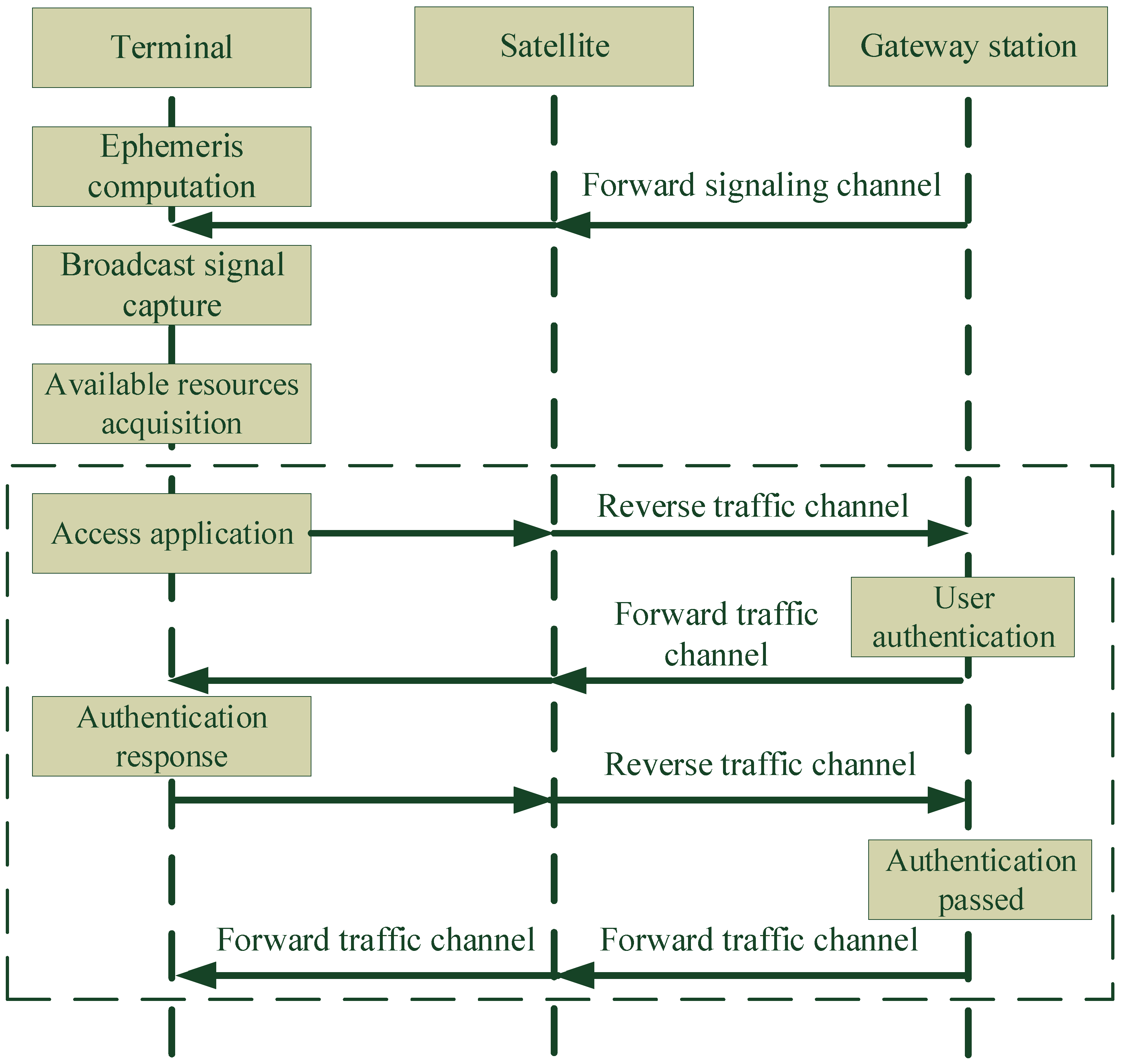
3.1. Random Access Technology of Remote Sensing Users

Users can access satellite Internet anytime and anywhere without relying on the terrestrial network based on the LEO broadband communication terminal, as shown in Figure 3.
Under the mode of random access, the location and access time of the terminal are unknown to the gateway station; thus, the terminal can only acquire beam resources through competition. The process of terminal access under random access mode is shown in Figure 4 as follows:
(1)
The terminal calculates the orbit of the satellite according to the built-in ephemeris, obtains the location of visible satellites, and then re-directs the antenna beam to complete the satellite tracking.
(2)
In the absence of ephemeris, the terminal scans the airspace to search for visible satellites and capture the broadcast signal. The ephemeris information in the broadcast signal is used to complete satellite ephemeris updates, hence realizing the satellite tracking.
(3)
The terminal sends a random access request over a dedicated access channel.
(4)
The gateway station determines whether the authentication is passed and accepts the application for terminal access.

3.2. Random Access Technology of Remote Sensing Satellites

In the NRRS architecture based on satellite Internet, remote sensing satellites receive shooting requirements via inter-satellite links, and send back the remote sensing data with high capacity. As shown in Figure 5, when transmitting data, the remote sensing satellite first establishes the connection with an LEO communication satellite through the omni-directional narrow-band link, and facilitates the establishment of high-speed laser links [33]. The high-capacity remote sensing data are relayed by other LEO communication satellites and transmitted back to the ground through feeder links of the gateway station.
Due to the fact that the satellites are moving at high speed in orbit, access to the satellite Internet of remote sensing satellites requires addressing some key techniques, such as rapid capture and tracking of laser terminals, robust chain building, data-link switching, etc.

3.3. Near Real-Time Edge Computing Technology

Near real-time edge computing consists of satellite in-orbit processing and ground processing of user terminals [34,35]. In-orbit processing compresses the redundant data to reduce the amount of down-link data. With the reduction in satellite manufacturing and launching costs, satellites can be equipped with higher-performance computers. The in-orbit processing technology is mainly clarified into three directions: (i) in-orbit remote sensing task planning and near real-time data distribution; (ii) image restoration tasks, including radiometric correction, geometric correction, etc., which are typically completed on the ground; (iii) tasks that are closely related to remote sensing users, including image segmentation, target detection, identification, tracking, etc. For the scenarios with limited satellite onboard processing capability, satellite Internet terminals or portable remote sensing terminals carry out near real-time processing after receiving remote sensing data, including geometric correction, radiation correction, information extraction, etc.

3.4. Dynamic Network Scheduling and Task Planning Technology

The operational and managerial challenges of remote sensing service systems are exacerbated by the diverse needs of users, the randomness of those needs, and the intricate nature of satellite resources. There exists the case of multiple users accessing the satellite resources. Real-time remote sensing services (NRRS), based on satellite Internet technology, effectively address these challenges through comprehensive scheduling and control of measurement and operational resources. This includes managing random access between space and Earth, planning information transmission paths, and utilizing the ICRS application system (refer to Figure 1). Moreover, remote sensing tasks take into account the priority of the mission and the capacity of the system resources to call for satellite resources. The result is a system that achieves rapid responsiveness to user needs. Two key technologies need to be addressed:
Firstly, the scheduling management of highly dynamic satellite networks involves crucial elements such as inter-satellite link state perception, network time synchronization, topology planning and control, and routing scheduling. This encompasses routing control and service transmission based on inputs such as inter-satellite and satellite ground network topology, business modes, and routing strategies.
Secondly, task planning under complex constraint conditions necessitates the resolution of challenging issues like complex constraint modeling, intricate problem solving, and integrated planning for both satellite ground and inter-satellite collaboration.

4. Application Scenarios and Superiority Analysis

4.1. Potential Application Scenarios

Compared with traditional satellite remote sensing systems, the presented system can achieve near real-time performance in all aspects, including demand collection, task planning, data download, image processing, information transmission, and can be applied to emergency and disaster relief, environmental protection, marine law enforcement, news media, etc.
  • Emergency and Disaster Relief: The NRRS system can immediately send the images of the disaster location back to the command center, as well as rapidly access historical images for comparison, so as to support on-site personnel in disaster research and rescue assessment.
  • Environment Protection: Compared with traditional remote sensing, the time-sensitive RtTS system can detect the behaviors that endanger the environment in time, respond immediately, and improve ecological environment monitoring.
  • Marine Law Enforcement: The NRRS service can identify and track illegal ships in a timely manner, improve law enforcement efficiency, protect marine fishery resources, and maintain maritime security and stability.
  • News Media: The NRRS service optimizes the efficiency of news data collection, transmission, and distribution. Reporters can obtain images efficiently, conveniently, and intuitively.

4.2. Superiority Analysis

The advantages of the NRRS architecture based on satellite Internet can be summarized as follows:
  • Response in Real Time: The ICRS application system guarantees the task planning, command upload, data transmission and distribution immediately, which allows for immediate (minutes) and routine (hours) mission response for imaging of the target area.
  • Ubiquitous and Efficient: Remote sensing satellites access the Internet as information nodes, and the commands and data are transmitted instantly via the satellite communication network with global coverage. The task uploading and data downloading no longer rely on the limited resources of TT&C and data-receiving stations on the ground, hence greatly improving the information transmission rate. With the help of mobile terminals, the requirements for remote sensing can be proposed, as well as the remote sensing images of the target area which can be received anytime and anywhere.
  • Intelligent Fusion: The intelligent algorithms on board and on the ground facilitate completing the rapid interpretation and execution of remote sensing requirements, as well as the transmission and processing of remote sensing images. Through intelligent task planning of remote sensing, multi-satellite collaborative resource scheduling, comparison and pre-processing of massive remote sensing data, etc., rapid response to the users’ demand and near real-time acquisition of remote sensing images can be guaranteed.

5. Experimental Progress

In this section, recent experimental progress in NRRS based on a test satellite constellation is summarized. Since there are no inter-satellite links in the test satellite constellation, it is still unable to build a complete NRRS architecture. This experiment mainly verifies parts of the NRRS services, i.e., user demand collection and data distribution through the satellite Internet.

5.1. Introduction of the Test Satellite Constellation

In March 2022, the company GalaxySpace launched six LEO broadband communication satellites into orbit, building China’s first LEO test constellation for broadband communication together with GalaxySpace’s first satellite (YINHE-1). The constellation is capable of providing uninterrupted, low-latency broadband communication services for more than 30 min each time. The distribution of the satellites is shown in Figure 6, where GS2, AP01, AP02, BP01, BP02, and AP03 are in the same orbit with phase intervals of 15∼18°. Four of the satellites are named “BUPT-YINHE” (“BUPT” is the abbreviation of Beijing University of Posts and Telecommunications.), “Nantong-1”, “Yitu Space Wish”, and “Xuancheng-1”. The BUPT-YINHE satellite participated in this experiment as a shared platform for communication and remote sensing payloads.

5.1.1. Communication Capability of the Satellite

The satellite communication payload is equipped with 16 V-Ka forward link transponders with a bandwidth of 450 MHz, and 16 Ka-V return link transponders with a bandwidth of 400 MHz. The satellite adopts the transparent forwarding mode to communicate with the gateway station and satellite terminal.
During the task, the Z-axis (normal direction of the user antenna mounting surface) of the satellite is controlled to point to the user end position on the ground, to enable longer continuous communication. Through multi-satellite relays, broadband continuous communication can be realized for a specific terminal in a designated area for more than 30 min, which can meet the demand for near real-time bandwidth transmission of remote sensing information [36]. The rotation ranges of antennas on the satellite are listed in Table 1.
Due to power and thermal limitation, broadband communication payload cannot work continuously in orbit. Therefore, the satellite calculates the working time of the communication payload based on the uploaded user end position (longitude, latitude, and elevation), and then implements power on and off of the payload equipment according to the control sequence of the satellite attitude and QV antennas.

5.1.2. Earth Observation Capability of the Satellite

The camera carried by the satellite can output RGB color images with a resolution better than 2 m@500 km with an imaging range of 60°. The original data volume of a single photo is approximately 2 GB. The satellite supports multiple working modes, such as staring imaging, push-broom, and video imaging. Based on the pre-acquired time and target location information, the satellite controls the camera to switch on and off to complete the imaging task. After imaging, the image data will be stored in the solid-state recorder. According to the pre-embedded program onboard the satellite or the commands from the ground, the stored information will be downloaded to the ground service station via the data transmission equipment. The phased array antenna is adopted for data transmission with the antenna beam range 0∼ 360 , maximum off-axis angle 60°, half power beam-width 20°. The available range for data transmission can be calculated by the satellite orbit, data-receiving station resources, as well as properties of the phased array antenna listed above.
During the remote sensing task, the satellite needs to conduct an attitude maneuver according to the communication object or imaging target. The attitude maneuver is usually started 450 s before the task to ensure that the camera captures the target.

5.2. Resources of the Ground Segment

The ground system is responsible for the TT&C and OC&M, communication management of the LEO satellite and constellation, user operation management, etc. It is mainly composed of gateway stations, TT&C stations, data receiving stations, and a center for TT&C and OC&M. The TT&C stations that which are in cooperation with GalaxySpace are shown in Figure 7, with a total of 40 antennas. The gateway station in Shangzhuang, Beijing, with coordinates 40.1173° N, 116.209° E, was used for this RtTS experiment.
For near real-time remote sensing services, GalaxySpace has developed an ICRS application system, which is responsible for user demand collection, near real-time remote sensing task planning, task status monitoring, near real-time data distribution, etc. The ICRS application system can interact with TT&C and OC&M centers through a network interface.

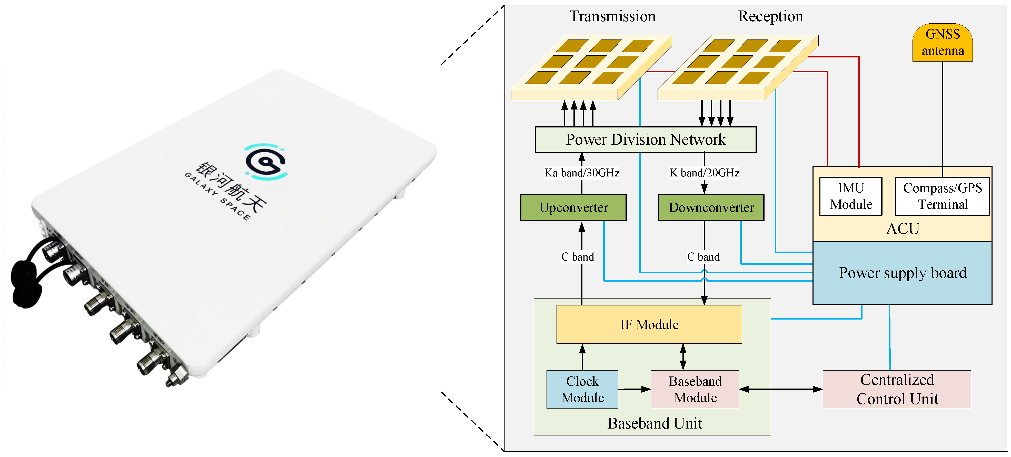
5.3. Communication Test of User Terminals

The user terminal is mainly used for high-precision satellite tracking, Ka-band signal transceiver and processing, baseband signal and communication protocol processing, etc. In order to facilitate user access, the vehicle-mounted Satcom on-the-move (STOM) phased array antenna with a 0.45 m equivalent aperture is adopted, as shown in Figure 8.
After obtaining the satellite ephemeris, terminal location, and signal information, the STOM phased array antenna can precisely lock and track the satellite signal through beam switching. A STOM test (120 km/h) between the 0.45 m terminal and gateway station was conducted based on the LEO test constellation. The single-beam staring mode was adopted for remote sensing data transmission. The results in Table 2 showed that the transmission delay between the satellite communication terminal and the gateway station was about 40 ms (with maximum 47 ms and minimum 38 ms). The results in Table 3 showed that the average communication speed is about 45 Mbps (with maximum 45.4 Mbps and minimum 44.5 Mbps), which can meet the time-sensitive communication requirements of NRRS service, and can support the access of a large number of terminals, considering the broadband feature of the satellite.
A long-range communication test of 1560 km from Chengdu to Beijing was conducted on 1 May 2022. The telemetry results of the satellite attitude and angular velocity are shown in Figure 9. The overlapped green and blue lines are close to zero. Due to the fact that the satellite mainly performs pitch maneuvers, the other two angles are kept as stable as possible. However, since disturbances exist in the system, there are steady-state errors in the attitude and angular velocity control. The angle evolution of the satellite feeder antenna and the terminal SNR results are illustrated in Figure 10 and Figure 11, respectively. It is shown that the maximum forward SNR is about 14 dB, and the maximum return SNR is about 7 dB, which can meet the demodulation threshold and link margin of the satellite communication. The communication time between the terminal and the satellite is nearly 5 min.

5.4. NRRS Task Design

Since the test constellation does not possess inter-satellite links, the ground station is used as a relay to simulate inter-satellite data transmission for near real-time remote sensing. The NRRS experiment is demonstrated in Figure 12 with the following steps:
(1)
The user accesses the satellite Internet based on the STOM terminal and submits remote sensing demands.
(2)
The satellite GS2 forwards the remote sensing requirements to the gateway station.
(3)
The ICRS application system responds to user requirements, carries out task planning, and gives feedback on task status.
(4)
The TT&C station uploads the shooting commands to the remote sensing satellite BP01 through.
(5)
The satellite BP01 starts attitude maneuver 450 s in advance and starts imaging after attitude adjustment.
(6)
The remote sensing satellite observes the target and sends images to the data receiving station simultaneously.
(7)
The data receiving station uploads the image data to the ICRS application system for near real-time processing and original image analysis, then refreshes the task status.
(8)
The gateway station forwards the processed image data to the satellite AP03.
(9)
The user accesses the satellite Internet and ICRS application system again to obtain the images.
It is worth noting that the satellites cannot perform in-orbit processing and inter-satellite transmission. Therefore, in this experiment, the original data are forwarded to the data receiving station for processing, and then distributed through another satellite to replace the process of in-orbit processing and inter-satellite transfer. In addition, since the data receiving station cannot process data, the original image files are uploaded to the ICRS application system for processing. Since the original files are approximately 2 GB, the connection speed between the terrestrial network and data receiving station is limited to 100 Mbps. If the image can be processed at the data receiving station, the NRRS process can be further reduced by 2–3 min.

5.5. NRRS Task Planning

Due to the limited number of in-orbit satellites in the test constellation (hence the limited area for communication), NRRS can not be achieved anytime and anywhere. In order to validate this presented NRRS architecture, task planning should be carried out on the basis of existing satellite and station resources. Based on the experiment illustrated in Figure 12, the workflow of NRRS task planning can be generated in Figure 13. The constraints for filter and match are listed as follows:
(1)
The demand collection needs to be within the communication arc of the satellite GS2, and the duration should be ≥2 min.
(2)
Command generation and upload time ≥3 min.
(3)
Command upload should be in the TT&C arc of satellite BP01.
(4)
The time from the end of command upload to the start of remote sensing should be >450 s.
(5)
The imaging time lasts for 2 min and should be kept within the data-receiving arc of BP01.
(6)
The total duration of the file upload and image processing ≥7 min.
(7)
Image data distribution is completed in the communication arc of AP03.
Key timing nodes of the NRRS experiment are shown in Figure 14.

5.6. Experimental Results

Before the experiment, four tests were carried out, including remote image processing, network server transfer test, satellite networking test, and joint test of data processing and transfer. Through these tests, the ability of data transmission and analysis, near real-time image processing, remote operation, etc., was verified, and the test duration and latency were evaluated.
On 5 June 2022, the NRRS task was uploaded to the satellite BP01 at the TT&C station in Kashgar (39.49° N, 75.75° E), and the image data were downloaded at the Lijiang station (26.70° N, 100.03° E). The task uploading and data transmission were completed in a single orbital cycle of BP01. The satellite implemented imaging of the target at 92.06° E and 27.7° N and completed near real-time data downloading. The whole process took about 15 min. It took 141 s for image extraction and 158 s for image processing.
On 3 September 2022, the 0.45 m broadband STOM terminal was used to establish a communication link with GS2 and accessed the ICRS application system. The TT&C station uploaded the planned task to BP01 through the Lijiang station, then BP01 implemented imaging and data transmission when passing by the data receiving station in Hulunbuir. The coordinates of the target location are 119.7° E and 49.2° N, and the whole process took about 18 min.
On 18 October 2022, satellite BP01 implemented imaging and data transmission when passing by the data receiving station in Qitaihe (45.84° N, 130.98° E). The coordinates of the target location are 120.3° E and 36.5° N. The image files were analyzed in the ICRS application system. The test personnel used a 0.45m broadband STOM terminal to access the ICRS application system via the established communication link with AP03 and obtained the remote sensing image. The whole process took about 30 min.
Another experiment was completed in Nantong (31.89° N, 120.95° E), China, on 7 November 2022. Using a broadband communication terminal, the test personnel accessed the ICRS application system through satellite GS2, and uploaded the planned task to BP01 via the Hulunbuir station (50.98° N, 121.04° E). BP01 implemented imaging and data transmission when passing by the data receiving station in Tongchuan (34.93° N, 108.89° E). The coordinates of the target location are 108.89° E and 34.93° N. The image files were processed in the ICRS application system. The test personnel used the broadband communication terminal to access the ICRS application system via the established communication link with AP03 and obtained the remote sensing image. The whole process took less than 25 min. The time nodes can be found in Table 4.

6. Conclusions

In this study, a ubiquitous near real-time remote sensing (NRRS) architecture based on LEO satellite Internet was proposed to provide the access capability for remote sensing demand collection and data distribution anytime and anywhere. Several NRRS experiments were carried out based on a test constellation consisting of seven low earth orbit (LEO) satellites. The results show that the LEO broadband Satcom on-the-move (STOM) terminal has the capability of high-speed access and broadband communication, and can be applied to NRRS scenarios with low latency and large bandwidth. It takes less than 25 min from the remote sensing task application to achieve image acquisition, which shows the satisfactory timeliness of the NRRS system. With the construction and application of the satellite Internet, it is expected to fully realize near real-time remote sensing within several minutes.
The future work will attempt to address several practical issues, such as quantitative research on data latency, data storage versus offloading capacity, onboard processing capability, etc.

Author Contributions

Conceptualization, P.Z., S.Z. and X.Z.; methodology, P.Z. and Q.Q.; software, P.Z. and W.W.; validation, P.Z., X.Y. and W.W.; formal analysis, H.Z.; investigation, P.Z. and X.Z.; writing—original draft preparation, P.Z. and X.Z.; writing—review and editing, Q.Q., S.Z., X.Y., W.W. and H.Z.; visualization, X.Y. and P.Z.; supervision, S.Z. All authors have read and agreed to the published version of the manuscript.

Funding

This research was funded by China Postdoctoral Science Foundation (Grant number: 2023M730337).

Data Availability Statement

The data presented in this study are available on request from the corresponding authors.

Acknowledgments

The authors would like to thank Tianhao Zhang and Weiwei Liu for their contribution to NRRS task planning system; Yiting Li and Anqi Li for the architectural description; Mu Yang, Guangrong Lin, Quanyou Qu, Peng Wang, Xianyu Zhang, Guodong Li, Huijing Fan, Meng He, and Yong Cai for assistance with the NRRS experiments; and Ensheng Wang for image processing.

Conflicts of Interest

Peng Zhang, Qin Qin, Shijie Zhang, Xiaoliang Yan, Wei Wang, and Hongbin Zhang were employed by Yinhe Hangtian (Beijing) Communication Technology Co., Ltd. The remaining authors declare that the research was conducted in the absence of any commercial or financial relationships that could be construed as a potential conflict of interest.

References

  1. Chuvieco, E.; Aguado, I.; Salas, J.; García, M.; Yebra, M.; Oliva, P. Satellite remote sensing contributions to wildland fire science and management. Curr. For. Rep. 2020, 6, 81–96. [Google Scholar] [CrossRef]
  2. Zhou, D.; Xiao, J.; Bonafoni, S.; Berger, C.; Deilami, K.; Zhou, Y.; Frolking, S.; Yao, R.; Qiao, Z.; Sobrino, J.A. Satellite remote sensing of surface urban heat islands: Progress, challenges, and perspectives. Remote Sens. 2018, 11, 48. [Google Scholar] [CrossRef]
  3. Weiss, M.; Jacob, F.; Duveiller, G. Remote sensing for agricultural applications: A meta-review. Remote Sens. Environ. 2020, 236, 111402. [Google Scholar] [CrossRef]
  4. Safyan, M. Planet’s dove satellite constellation. In Handbook of Small Satellites: Technology, Design, Manufacture, Applications, Economics and Regulation; Springer International Publishing: Cham, Switzerland, 2020; pp. 1–17. [Google Scholar]
  5. Smith, K.E.; Terrano, J.F.; Pitchford, J.L.; Archer, M.J. Coastal wetland shoreline change monitoring: A comparison of shorelines from high-resolution WorldView Satellite imagery, aerial Imagery, and field surveys. Remote Sens. 2021, 13, 3030. [Google Scholar] [CrossRef]
  6. Castelletti, D.; Farquharson, G.; Stringham, C.; Duersch, M.; Eddy, D. Capella Space First Operational SAR Satellite. In Proceedings of the 2021 IEEE International Geoscience and Remote Sensing Symposium IGARSS, Brussels, Belgium, 11–16 July 2021; pp. 1483–1486. [Google Scholar]
  7. Wei, J.; Yang, H.; Tang, W.; Li, Q. Spatiotemporal-Spectral Fusion for Gaofen-1 Satellite Images. IEEE Geosci. Remote Sens. Lett. 2021, 19, 1–5. [Google Scholar] [CrossRef]
  8. Guk, E.; Levin, N. Analyzing spatial variability in night-time lights using a high spatial resolution color Jilin-1 image–Jerusalem as a case study. ISPRS J. Photogramm. Remote Sens. 2020, 163, 121–136. [Google Scholar] [CrossRef]
  9. Wu, X.; Yang, Y.; Sun, Y.; Xie, Y.; Song, X.; Huang, B. Dynamic regional splitting planning of remote sensing satellite swarm using parallel genetic PSO algorithm. Acta Astronaut. 2023, 204, 531–551. [Google Scholar] [CrossRef]
  10. Caon, M.; Ros, P.M.; Martina, M.; Bianchi, T.; Magli, E.; Membibre, F.; Ramos, A.; Latorre, A.; Kerr, M.; Wiehle, S.; et al. Very low latency architecture for earth observation satellite onboard data handling, compression, and encryption. In Proceedings of the 2021 IEEE International Geoscience and Remote Sensing Symposium IGARSS, Brussels, Belgium, 11–16 July 2021; pp. 7791–7794. [Google Scholar]
  11. Alves de Oliveira, V.; Chabert, M.; Oberlin, T.; Poulliat, C.; Bruno, M.; Latry, C.; Carlavan, M.; Henrot, S.; Falzon, F.; Camarero, R. Reduced-complexity end-to-end variational autoencoder for on board satellite image compression. Remote Sens. 2021, 13, 447. [Google Scholar] [CrossRef]
  12. Wang, L.; Meng, J. Constellation Design and Application of Real-Time Space-Based Information Services Supporting Communication, Navigation and Remote Integration. In Proceedings of the International Conference in Communications, Signal Processing, and Systems, Melmaruvathur, India, 28–30 July 2020; pp. 1869–1878. [Google Scholar]
  13. MAXAR. Rapid Access Program: Stay on Top of Ever-Changing Ground Conditions. 2022. Available online: https://www.maxar.com/products/rapid-access-program (accessed on 2 December 2022).
  14. MAXAR. Direct Access Program: Priority Imagery at Your Command. 2022. Available online: https://www.maxar.com/products/direct-access-program (accessed on 2 December 2022).
  15. MAXAR. Tactical Access Program. 2022. Available online: https://resources.maxar.com/data-sheets/tactical-access-program (accessed on 2 December 2022).
  16. Del Portillo, I.; Cameron, B.G.; Crawley, E.F. A technical comparison of three low earth orbit satellite constellation systems to provide global broadband. Acta Astronaut. 2019, 159, 123–135. [Google Scholar] [CrossRef]
  17. Marcuccio, S.; Ullo, S.; Carminati, M.; Kanoun, O. Smaller satellites, larger constellations: Trends and design issues for earth observation systems. IEEE Aerosp. Electron. Syst. Mag. 2019, 34, 50–59. [Google Scholar] [CrossRef]
  18. Gong, Y.; Zhang, S.; Peng, X. Quick coverage analysis of mega Walker Constellation based on 2D map. Acta Astronaut. 2021, 188, 99–109. [Google Scholar] [CrossRef]
  19. Huang, S.; Colombo, C.; Bernelli-Zazzera, F. Multi-criteria design of continuous global coverage Walker and Street-of-Coverage constellations through property assessment. Acta Astronaut. 2021, 188, 151–170. [Google Scholar] [CrossRef]
  20. McDowell, J.C. Starlink Statistics. 2022. Available online: https://planet4589.org/space/con/star/stats.html (accessed on 2 December 2022).
  21. McDowell, J.C. The low earth orbit satellite population and impacts of the SpaceX Starlink constellation. Astrophys. J. Lett. 2020, 892, L36. [Google Scholar] [CrossRef]
  22. OneWeb. OneWeb Confirms Successful Deployment of 40 Satellites Launched with SpaceX. 2022. Available online: https://oneweb.net/resources/oneweb-confirms-successful-deployment-40-satellites-launched-spacex (accessed on 9 December 2022).
  23. OneWeb. OneWeb Completes Its ‘Five to 50’ Mission to Cover Regions North of 50 Degrees Latitude including UK, Canada, Alaska and Arctic Region. 2021. Available online: https://oneweb.net/resources/oneweb-completes-its-five-50-mission-cover-regions-north-50-degrees-latitude-including-uk (accessed on 9 December 2022).
  24. Lai, Z.; Wu, Q.; Li, H.; Lv, M.; Wu, J. OrbitCast: Exploiting Mega-Constellations for Low-Latency Earth Observation. In Proceedings of the 2021 IEEE 29th International Conference on Network Protocols (ICNP), Dallas, TX, USA, 1–5 November 2021; pp. 1–12. [Google Scholar]
  25. Peng, M.; Zhang, S.; Xu, H.; Zhang, M.; Sun, Y.; Cheng, Y. Communication and remote sensing integrated LEO satellites: Architecture, technologies and experiment. Telecommun. Sci. 2022, 38, 13–24. [Google Scholar]
  26. Space Development Agency. Space Development Agency Next-Generation Space Architecture Request for Information; Space Development Agency: Arlington, VA, USA, 2019. [Google Scholar]
  27. Turner, F. Creating the JACD2 Central Support Structure–The NDSA Transport Layer; Space Development Agency: Washington, DC, USA, 2022. [Google Scholar]
  28. Lv, T.; Liu, W.; Huang, H.; Jia, X. Optimal data downloading by using inter-satellite offloading in leo satellite networks. In Proceedings of the 2016 IEEE Global Communications Conference (GLOBECOM), Washington, DC, USA, 4–8 December 2016; pp. 1–6. [Google Scholar]
  29. Li, S.; Hou, K.; Cheng, C.; Li, S.; Chen, B. A space-interconnection algorithm for satellite constellation based on spatial grid model. Remote Sens. 2020, 12, 2131. [Google Scholar] [CrossRef]
  30. Jia, X.; Lv, T.; He, F.; Huang, H. Collaborative data downloading by using inter-satellite links in LEO satellite networks. IEEE Trans. Wirel. Commun. 2017, 16, 1523–1532. [Google Scholar] [CrossRef]
  31. Ortiz-Gomez, F.G.; Salas-Natera, M.A.; Martínez, R.; Landeros-Ayala, S. Optimization in VHTS satellite system design with irregular beam coverage for non-uniform traffic distribution. Remote Sens. 2021, 13, 2642. [Google Scholar] [CrossRef]
  32. Li, A.; Huang, P.; Shi, L.; He, G.; Feng, X.; Wu, Y.W.; Zhang, Q.; Ma, G.B.; Feng, K.; Yang, J. Update of Remote Sensing Satellite Ground System of China Remote Sensing Satellite Ground Station. J. Remote Sens. 2021, 25, 251–266. [Google Scholar]
  33. Knopp, M.T.; Spoerl, A.; Gnat, M.; Rossmanith, G.; Huber, F.; Fuchs, C.; Giggenbach, D. Towards the utilization of optical ground-to-space links for low earth orbiting spacecraft. Acta Astronaut. 2020, 166, 147–155. [Google Scholar] [CrossRef]
  34. Xie, R.; Tang, Q.; Wang, Q.; Liu, X.; Yu, F.R.; Huang, T. Satellite-terrestrial integrated edge computing networks: Architecture, challenges, and open issues. IEEE Netw. 2020, 34, 224–231. [Google Scholar] [CrossRef]
  35. Song, Z.; Hao, Y.; Liu, Y.; Sun, X. Energy-efficient multiaccess edge computing for terrestrial-satellite Internet of Things. IEEE Internet Things J. 2021, 8, 14202–14218. [Google Scholar] [CrossRef]
  36. Sun, Y.; Peng, M.; Zhang, S.; Lin, G.; Zhang, P. Integrated Satellite-Terrestrial Networks: Architectures, Key Techniques, and Experimental Progresses. IEEE Netw. 2022, 36, 191–198. [Google Scholar] [CrossRef]
Figure 1. Architecture of near real-time remote sensing based on satellite Internet.
Aerospace 11 00167 g001
Figure 2. Workflow comparison of NRRS based on satellite Internet and traditional remote sensing.
Aerospace 11 00167 g002
Figure 3. Illustration of random access of remote sensing users to the satellite Internet.
Aerospace 11 00167 g003
Figure 4. Terminal access process under random access mode.
Aerospace 11 00167 g004
Figure 5. Illustration of random access of remote sensing satellites to the satellite Internet.
Aerospace 11 00167 g005
Figure 6. Illustration of the LEO test constellation for broadband communication.
Aerospace 11 00167 g006
Figure 7. Illustration of TT&C stations that have cooperation with GalaxySpace.
Aerospace 11 00167 g007
Figure 8. STOM phased array antenna produced by GalaxySpace.
Aerospace 11 00167 g008
Figure 9. Eveolution of the satellite attitude and angular velocity during staring communication (green line: roll, yellow line: pitch, blue line: yaw).
Aerospace 11 00167 g009
Figure 10. Angle eveolution of the satellite feeder antenna during staring communication (green line: rotation angle of QV1 antenna X-axis, yellow line: rotation angle of QV1 antenna Y-axis, blue line: rotation angle of QV2 antenna X-axis, orange line: rotation angle of QV2 antenna Y-axis).
Aerospace 11 00167 g010
Figure 11. The SNR results and communication time of the STOM terminal.
Aerospace 11 00167 g011
Figure 12. Illustration of the NRRS experiment.
Aerospace 11 00167 g012
Figure 13. Workflow of the NRRS task planning.
Aerospace 11 00167 g013
Figure 14. Key timing nodes of the NRRS experiment.
Aerospace 11 00167 g014
Table 1. Q/V antenna parameters.
AxisAntennaRange
Xboth 10 + 63
YQ/V antenna-1 72 + 63
Q/V antenna-2 63 + 72
Table 2. Latency results in STOM test.
FromReply
192.168.91.200Byte = 32; Time = 42 ms; TTL = 63
192.168.91.200Byte = 32; Time = 39 ms; TTL = 63
192.168.91.200Byte = 32; Time = 47 ms; TTL = 63
192.168.91.200Byte = 32; Time = 44 ms; TTL = 63
192.168.91.200Byte = 32; Time = 40 ms; TTL = 63
192.168.91.200Byte = 32; Time = 38 ms; TTL = 63
Table 3. Communication speed results in STOM test.
TimeData VolumeSpeed
25.00–26.01 s5.38 Mbytes45.0 Mbits/s
26.01–27.01 s5.38 Mbytes45.1 Mbits/s
27.01–28.01 s5.35 Mbytes45.0 Mbits/s
28.01–29.01 s5.30 Mbytes44.6 Mbits/s
29.01–30.01 s5.37 Mbytes45.1 Mbits/s
31.01–32.01 s5.43 Mbytes45.4 Mbits/s
31.01–32.01 s5.38 Mbytes44.8 Mbits/s
32.01–33.01 s5.32 Mbytes44.5 Mbits/s
Table 4. Time notes in the NRRS experiment.
ItemTime
Task submit2022-11-07 13:10:00
Command upload2022-11-07 13:12:42
Data transmission start2022-11-07 13:22:59
Shooting start2022-11-07 13:23:22
Shooting end2022-11-07 13:25:22
Data transmission end2022-11-07 13:25:31
Image files upload to the ICRS system2022-11-07 13:27:46
File analysis completed2022-11-07 13:31:19
Images obtained2022-11-07 13:33:44
Disclaimer/Publisher’s Note: The statements, opinions and data contained in all publications are solely those of the individual author(s) and contributor(s) and not of MDPI and/or the editor(s). MDPI and/or the editor(s) disclaim responsibility for any injury to people or property resulting from any ideas, methods, instructions or products referred to in the content.

