


Research on the Reconstruction of Aquatic Vegetation Landscape in Coal Mining Subsidence Wetlands Based on Ecological Water Level
School of Architecture and Design, China University of Mining and Technology, Xuzhou 221116, China
*
Author to whom correspondence should be addressed.
Water 2024, 16(10), 1339; https://doi.org/10.3390/w16101339
Submission received: 10 April 2024
/
Revised: 3 May 2024
/
Accepted: 4 May 2024
/
Published: 8 May 2024
(This article belongs to the Topic Aquatic Environment Research for Sustainable Development)
Abstract
:The eastern region of the Huang-Huai area is vital for China’s coal production, with high water table mining causing significant surface subsidence and the formation of interconnected coal mining subsidence wetlands. Restoring these wetlands is crucial for biodiversity, environmental quality, and sustainable development. Aquatic vegetation plays a crucial role in wetland ecosystems, underscoring its importance in restoration efforts. Understanding and managing water level fluctuations is essential due to their impact on vegetation. This study examines the Qianshiliying coal mining subsidence wetland in the Yanzhou Mining Area, China, with the goal of devising a water level regulation plan based on the minimum ecological water level to improve the growth and recovery of aquatic vegetation. The research delves into landscape ecological restoration techniques for aquatic vegetation in coal mining subsidence wetlands in the eastern Huang-Huai region, emphasizing the importance of water level management. The results reveal that the minimum ecological water level in the Qianshiliying coal mining subsidence wetland is 32.50 m, and an area of 78.09 hectares is suitable for the reconstruction of aquatic vegetation. This paper utilizes lake morphology, minimum biological space, and water level demand methods for aquatic plants in the landscape to promote restoration of coal mining subsidence wetlands. A notable strength of this approach is its ability to quantitatively predict the survival range and area of aquatic vegetation in these wetlands, enabling a more scientifically informed restoration of ecological balance and promoting landscape ecological restoration in the eastern Huang-Huai region.
1. Introduction
The exploitation and utilization of coal resources have been associated with a range of ecological issues, such as vegetation degradation, biodiversity decline, and the degradation of lakes and rivers. In the eastern Huang-Huai region, coal seams are predominantly extracted using the room-and-pillar technique, which disturbs the mechanical equilibrium of the overlying strata [1]. The exploitation and utilization of coal resources have been associated with a range of ecological issues, such as vegetation degradation, biodiversity decline, and the degradation of lakes and rivers. In the eastern Huang-Huai region, coal seams are predominantly extracted using the room-and-pillar technique, which disturbs the mechanical equilibrium of the overlying strata [2]. The eastern Huang-Huai region boasts abundant underground water resources, resulting in relatively high water tables. Due to a combination of precipitation and groundwater seepage from these high water tables, subsidence basins in the region can become seasonally or permanently waterlogged [3]. This waterlogging can cause the degradation and eventual disappearance of terrestrial vegetation that originally grew in the area before subsidence occurred. The decomposed vegetation, including crops, trees, and other plants, enriches the water with nutrients at the bottom of the basin. As the aquatic environment within the subsidence basin evolves over time, aquatic vegetation begins to dominate, leading to the gradual formation of wetland ecosystems. Ultimately, the subsidence basin transforms into a large coal mining subsidence wetland visible on the water surface [4,5].
Significant surface subsidence resulting from coal mining can lead to the formation of wetlands, triggering various environmental impacts. This subsidence can reduce the soil’s water retention capacity and permeability, causing water and nutrient loss. Human mining activities can also disrupt hydrological processes in subsidence areas, altering runoff patterns and affecting wetland recharge, discharge, and water storage. These changes in hydrogeological conditions can lead to the deterioration of wetland vegetation, a decline in animal populations, loss of ecological support functions, and the shrinkage and fragmentation of wetland landscapes. Without ecological restoration, coal mining subsidence wetlands typically have low coverage of aquatic vegetation and limited variety [6]. Aquatic vegetation, as a crucial element of wetland ecosystems [7,8,9], plays a significant role in enhancing the ecological environment of water bodies within wetlands [10]. Accordingly, the restoration of aquatic plants is deemed essential for effective wetland ecological management [11]. The hydrological processes involved significantly contribute to the formation and evolution of wetland ecosystems, thereby impacting the growth and progression of wetland vegetation [12,13]. Water level fluctuations serve as a key indicator in this process [14,15]. Different growth stages of aquatic vegetation have different water level requirements. Understanding the relationship between water levels and aquatic vegetation is crucial for implementing scientifically-based restoration methods in coal mining subsidence wetlands. These steps are essential prerequisites and effective strategies for reconstructing the aquatic vegetation landscape.
Restoring wetland vegetation is essential from the perspective of ecological water demand. Both domestic and foreign studies have predominantly concentrated on ecological water demand and ecological water levels. When considering ecological water demand, Robinson et al. [16] suggested that the minimum water requirement in lakes and wetlands was influenced by the behaviors of animals and plants. Junhong et al. and Ertsen and Derspek highlighted the distinction in calculating minimum water requirements for rivers and wetlands [17,18]. While river sections can be determined using hydraulic parameters like water flow velocity, wetlands are less influenced by these parameters. In wetland environments, the calculation of minimum water requirements is primarily based on water surface area, specifically for the entrances of lakes, and is referred to as minimum ecological water requirements [17,18]. Wang et al. and Shore et al. suggest that minimum water requirements in wetland environments are essential to prevent damage to wetland ecosystems under specific environmental conditions. These requirements represent the annual amount of water necessary for compensation [19,20]. Shabanov et al. believe that the minimum ecological water requirement is supplemented by runoff and precipitation [21]. In response to the growing emphasis on lake and wetland ecological water levels in recent years, Qiu Mengqi et al. [22] devised a system of indicators for assessing the ecological water needs of wetlands, particularly in the area of wetland vegetation restoration efforts. Researchers have proposed various calculation methods to establish the minimum ecological water level. Xu Zhixia et al. [23] conducted a comprehensive investigation on Nansi Lake, employing lake morphology analysis, examination of natural water level data, and analysis of the minimum biological space demand to determine the minimum ecological water level. Li Xinhu et al. [24] conducted a study on Bosten Lake, focusing on analyzing the minimum ecological water level through various methods such as the annual guarantee rate method, functional method, and curve correlation method. They compared the applicability, advantages, and disadvantages of these different approaches. Yang et al. [25] utilized both the lake morphology method and the minimum demand method for biological space to determine the minimum ecological water level of lakes. They also managed the water level during each stage of plant growth and development. Previous research on wetland ecological water quantity has predominantly concentrated on utilizing parameters and models to determine the ecological water demand of wetlands. Nonetheless, there has been limited exploration by scholars on regulating wetland ecological water quantity through the lens of wetland ecological water levels to enhance wetland landscape restoration. Some researchers have experimented with altering the water levels of lacustrine wetlands to facilitate the growth and restoration of aquatic vegetation; however, these modifications frequently depend excessively on external water sources. In this study, we determined the minimum ecological water level of coal mining subsidence wetlands by employing both the lake morphological method and the biological spatial minimum requirement method. We then calibrated the water level according to the intrinsic ecological needs of these wetlands, catering to the diverse water level requirements at different growth stages and minimizing the dependence on external water sources. Our purpose is to restore aquatic vegetation in coal mining subsidence wetlands. Restoring aquatic vegetation in coal mining subsidence wetlands can lead to natural restoration of damaged soil layers and water bodies. This process helps create habitats, restore the self-balancing ability of the wetlands, reduce reliance on external water sources, promote orderly restoration of the ecological landscape, and facilitate sustainable development of landscape ecology in these areas.
This study introduced a method for reconstructing aquatic vegetation landscapes impacted by water level fluctuations using the Qianshiliying coal mining subsidence wetland, located in the Yanzhou mining area of the eastern part of the Huanghuai River, as a case study. The findings from this research were then utilized in ecological restoration initiatives for coal mining subsidence wetlands in the same region. By conducting a thorough analysis of a specific case study, the study outlined a method for reconstructing aquatic vegetation landscapes, evaluated its validity, and explored its potential benefits, drawbacks, and applications in the ecological restoration of coal mining subsidence wetlands.
2. Materials and Methods
The research focused on the Qianshiliying coal mining subsidence wetland in Jining City, located in the eastern Huang-Huai region. Plots were established in the area using GIS(10.8) random sampling, followed by UAV aerial photography and field measurements for data collection on aquatic vegetation types and transparency levels. The minimum ecological water level of the wetland was determined based on data analysis using lake morphology and minimum biological space requirements. By applying the water level demand method for aquatic plants, suitable water depth ranges for different types of aquatic vegetation were identified, along with areas conducive to the growth of aquatic plants based on water transparency.
2.1. Research Area
The study focuses on the Qianshiliying coal mining subsidence wetland in Jining, China, as depicted in Figure 1. Jining is renowned for its rich mineral resources. This wetland is located in the Rencheng District of Jining City, close to the Guangfu River, a tributary of Nansihu in the Huai River Basin to the west. The Qianshiliying coal mining area exhibits perennial standing water due to abundant groundwater resources and relatively high groundwater levels. However, mining activities have impacted the hydrogeological conditions of the wetlands, resulting in significant soil erosion [26]. Through field research conducted from October to November 2023, the current ecological conditions of the Qianshiliying coal mining subsidence wetland were obtained and are shown in Figure 2. As can be seen, the wetland features low aquatic vegetation coverage dominated by a single species, and a limited presence of high niche biological species. The wetland soil is observed to undergo gleification and swampification as a result of continuous waterlogging. The wetland harbors numerous fish species, which provide a livelihood for the fishermen in the southeast part. In the eastern region, there is a significant presence of emergent plants like lotus and reed, showing a consistent pattern of planting. The shoreline of the Qianshiliying coal mining subsidence wetlands has a straightforward structure and serves a singular ecological purpose. The soil and hydrology of the Qianshiliying coal mining subsidence wetlands provide suitable conditions for habitat development, but the aquatic vegetation communities lack diversity, highlighting the need for urgent landscape ecological restoration.
2.2. Data Materials
The coal mining subsidence area in Qianshiliying covers an area of approximately 691.91 hectares, with an average surface subsidence value of 5.50 m. Since the subsidence value has exceeded 2.50 m, it was classified as a severely subsided area [27]. In October 2023, a field survey was carried out on the subsidence wetlands within the coal mining region of Qianshiliying. Sample plots were randomly established using GIS(10.8) within the survey area, with 2 sample strips in each plot. Each strip measured 2 m in width and 4–8 m in length. Within each strip, there were 2–4 plots, each with an area of 2 m × 2 m. In total, 18 sample plots, 36 sample strips, and 54 sample plots were set up in the Qianshiliying coal mining subsidence wetlands. The distribution of these sample plots is shown in Figure 3. On-site investigation utilized drone aerial photography (DJ-Innovations., Shenzhen, China) to identify and document the plant species within each sample plot (Figure 4). The meter ruler was used to measure the lower limit of the distribution range of water levels for aquatic plants. The transparency of the Qianshiliying coal mining subsidence wetlands during the dry season was recorded to be 0.5 m.
2.3. Research Methods
2.3.1. Lake Morphology Analysis Method
The lake morphology analysis method is particularly suitable for small lakes characterized by limited water level fluctuations and consistent basin development. In situations where long-term natural hydrological and ecological data are unavailable, this method can be utilized to establish the minimum ecological water level of lakes [28]. Using non-linear curve fitting with the data on lake water levels and areas, a correlation curve can be established between the depth of water and the surface area of the lake. When the water level fluctuates, the decrease in lake surface area per unit decrease in water level is not consistent. The curve illustrating the relationship between water level and surface area shows a peak value for the rate of change in lake surface area. This peak value indicates that beyond this point, each unit decrease in lake water level results in a substantial increase in the reduction in lake surface area. Essentially, as the water level nears this peak value, the reduction in lake surface area per unit decrease in water level accelerates, causing a notable impact on the lake’s hydrology and topography subsystems. Hence, the water level corresponding to the peak rate of change in surface area is defined as the minimum ecological water level (Figure 5).
2.3.2. Biological Space Minimum Demand Method
The biodiversity of aquatic ecosystems in lakes is maintained by a variety of organisms, including phytoplankton, emergent plants, zooplankton, and fish. Each of these biological communities requires a minimum living space, and a significant decrease in water level can result in damage to the integrity and biodiversity of the ecosystem. Aquatic plants, fish, and other organisms depend on a minimum ecological water level to prevent a substantial decline in their respective communities. Fish, in particular, occupy a unique niche within aquatic ecosystems and play a crucial role in supporting the populations of other organisms. Given their vulnerability to diminished water levels, fish are commonly utilized as indicators of ecosystem health [25,29].
where denotes the lowest ecological water level of the lake; is the bottom elevation of the lake; and is the minimum water depth required for fish.
2.3.3. Water Level Demand Method for Aquatic Plants
The plant growth period is typically divided into six stages: germination, seedling growth, growth diffusion, maturity, seed diffusion, and dormancy. Germination is the initial stage of plant growth, playing a crucial role in shaping the distribution of aquatic vegetation in the area. Therefore, the water level during germination is used as the baseline water level for predicting the potential germination area of aquatic vegetation. Based on this foundation, relationship models are established between the potential germination area of aquatic vegetation and water level, the potential coverage of aquatic vegetation and water level, as well as the coverage of aquatic vegetation and water level during the germination process.
Step 1. To establish a model for the relationship between water level and coal mining subsidence wetland area.
The water level in coal mining subsidence wetlands serves as an indicator of the terrain and hydrological conditions, while the water surface area is a reflection of the wetland’s functions. By analyzing the measured data on water level and water surface area in these wetlands, a relationship model is established with a non-linear fitting method. This model depicts the relationship between water level (independent variable) and water surface area of a mining subsidence wetland (dependent variable) [24].
where A represents the water surface area of the coal mining subsidence wetland (ha) and Z denotes the water level (m).
Step 2. To establish a model for the relationship between the potential germination area of aquatic vegetation and the water level at the time of germination.
The average water level at the time of germination is denoted as Zg, while the overall average water level is represented by Zc. There is an overlap in the survival range of hydrophytic and emergent plants, with both types able to germinate at the highest point of Zc. Additionally, emergent plants can germinate at a depth of 0.2 m below the water surface [30], indicated as Zg − 0.2 m. Therefore, the suitable water level range for germination of hydrophytic and emergent plants during the germination period is [Zg − 0.2, Zc]. The survival ranges of floating-leaved and submerged plants overlap, as both can germinate when the water level is at its highest during the germination period, Zg. Submerged plants have the ability to germinate at lower water levels, but they can only develop when the ratio of depth (SD) to water depth is greater than 0.6 [31]. The lower limit of water level for submerged plants is calculated as (where SD represents lake transparency). Therefore, the suitable water level range for both submerged and floating-leaved plants during the germination period is . By substituting the water level ranges during germination period for various types of aquatic plants into the relationship model between water level and the area of coal mining subsidence wetlands, a quantitative model can be established for the potential germination area of aquatic vegetation in coal mining subsidence wetlands during the germination period.
Step 3. To develop a model for the relationship between the potential coverage of aquatic plants and the water level during the germination period.
The potential coverage of aquatic vegetation can be determined by calculating the ratio of the potential germination area of aquatic vegetation (Ao) to the surface area of coal mining subsidence wetlands under average water level conditions (Ac). This ratio is a key indicator of the potential growth and spread of aquatic vegetation in these wetland areas.
By repeating Step 3, the potential coverage of aquatic vegetation can be calculated under any germination period water level. To be specific, values are assigned with an increment of 0.1 m, where the minimum value is the minimum ecological water level of the coal mining subsidence wetlands and the maximum value is the warning water level of the coal mining subsidence wetlands.
Step 4. To investigate the relationship between potential coverage of aquatic vegetation and actual coverage of aquatic vegetation.
The distribution of aquatic plants is influenced by various factors such as nutrient availability, seed bank, and substrate type, which can limit their coverage. As a result, the predicted potential coverage of aquatic vegetation often exceeds the actual observed values. This suggests a quantitative relationship between the actual and potential coverage of aquatic plants. As the water level of coal mining subsidence wetlands during the germination period is substituted into Equation (4), the potential coverage of aquatic vegetation can be calculated. By further considering the quantitative relationship between potential and actual coverage, a model can be developed to explore the relationship between aquatic vegetation coverage and water level.
3. Results
3.1. Species of Aquatic Plants
As is revealed by this study, the primary aquatic plant species identified in the coal mining subsidence wetlands in Qianshiliying include Typha orientalis, Schoenoplectus triqueter, Cyperus serotinus, Nelumbo nucifera, Alternanthera sessilis, Phragmites australis, and Vallisneria natans. Among these, the most prevalent aquatic plants with high coverage are Phragmites australis, Nelumbo nucifera, and Alternanthera sessilis, with Phragmites australis being the dominant species.
3.2. The Minimum Ecological Water Level
By means of lake morphology analysis, this study established the correlation between water level and surface area, depicted in Figure 6a, and the correlation between water level and the rate of surface area change, illustrated in Figure 6b, for the Qianshiliying coal mining subsidence wetlands. The findings show that the ecological water level for these wetlands can be identified as 33.25 m, aligning with the peak change rate in lake surface area.
Based on field surveys and relevant data, the primary fish and shrimp species found in the Qianshiliying coal subsidence wetland are carp, crucian carp, silver carp, grass carp, and freshwater shrimp. As per regulations concerning hydraulic habitat parameters for fish, it is generally recommended that the minimum water depth for fish should be two to three times their body length [11,32]. According to the underwater topographic data, the bottom elevation of the Qianshiliying coal subsidence wetland is 29.50 m. The maximum body length of each fish species in this wetland does not exceed 1 m, based on actual measurements. By calculating three times their body length, which equals 3 m, the ecological water level of the Qianshiliying coal subsidence wetland is determined to be 32.50 m, using the minimum space requirement method.
The lake morphology analysis method and the minimum space requirement method for biology have determined the minimum ecological water levels to be 33.25 m and 32.50 m, respectively. The lake morphology analysis method primarily considers hydrological and topographic factors, but fails to take essential biological indicators into account, thus, it has certain limitations [33]. On the other hand, the minimum space requirement method for biology is based on underwater topography and also considers the protection of biodiversity. Hence, with all these factors considered, the minimum ecological water level derived from the minimum space requirement method for biology, which is 32.50 m, is selected as the minimum ecological water level for the Qianshiliying coal subsidence wetland.
3.3. The Reconstruction Area and Coverage of Aquatic Vegetation
A non-linear fitting was conducted with water level as the independent variable and the surface area of the Qianshiliying coal subsidence wetland as the dependent variable. This resulted in the establishment of a relationship model , where A represents the surface area and Z represents the water level. The model exhibits a high goodness of fit, .
Based on the analysis of lake morphology and the minimum biological space method, it has been established that the optimal ecological water level for sustainable development is 32.50 m, aligning with the germination water level. The average water level in the Qianshiliying coal subsidence wetland is 33.30 m, with a visibility of 0.5 m in the dry season. As a result, the suitable range for aquatic vegetation survival in the Qianshiliying coal subsidence wetland is estimated to be meters. When the germination water level is defined as based on the function .
The potential coverage of aquatic vegetation in the Qianshiliying coal subsidence wetland is determined by the ratio of the potential germination area of aquatic plants to the surface area of the wetland at its normal water level , which is 318.49 hectares.
Increments of 0.1 m for Zg are used to determine the potential coverage of aquatic vegetation corresponding to each germination water level. As the germination water level increases from the minimum ecological water level of 32.50 m to the maximum warning water level of 34.10 m, there is a gradual decrease in potential vegetation coverage. A significant inverse relationship exists between the potential extent of underwater plant life and the water level needed for seed germination. An algorithm is, thus, created to forecast the potential plant coverage in wetlands affected by coal mining subsidence at different water levels for seed germination, as shown in Figure 7.
From February to March 2023, the average monthly water level in the Qianshiliying coal subsidence wetland was recorded as approximately 33.00 m. By substituting this measurement into Equation (9), the potential coverage of aquatic vegetation was estimated to be around 72.90%. However, upon actual measurement, the total coverage of aquatic vegetation in the wetland was found to be only 19.61%, roughly 26.90% of the model’s predicted value. In 2022, the water level in the Qianshiliying coal subsidence wetland during the germination period was approximately 33.00 m. The coverage of aquatic vegetation was around 18.27%, which was roughly 25.06% of the predicted value from the model. Under specific growth environmental conditions and factors such as vegetation species diversity, the coverage of aquatic vegetation in the Qianshiliying coal subsidence wetland is estimated to be around 30% of the potential coverage. Therefore, the formula for aquatic vegetation coverage can be represented as:
When the water level in the Qianshiliying coal subsidence wetland reaches the minimum ecological level of 32.50 m, the potential germination area of aquatic vegetation is 260.30 hectares. The overall range of potential germination water levels for aquatic vegetation is between 31.67 and 33.30 m. Specifically, the potential germination water levels for emergent and submerged aquatic plants are between 32.30 and 33.30 m, and between 31.67 and 32.50 m, respectively. The potential coverage of aquatic vegetation is estimated at 80%, as illustrated in Figure 8. The actual reconstructable area of aquatic vegetation is 30% of the potential germination, reaching up to 78.09 hectares, with the coverage rate being 24%.
3.4. Recommended Monthly Water Levels for Various Stages of Aquatic Vegetation Growth
As the predominant species in the Qianshiliying coal subsidence wetland, phragmites australis boasts the highest frequency of occurrence and coverage. As an emergent aquatic plant, reeds are able to elongate their stems, leaves, and nodes to access more sunlight and oxygen, allowing them to adapt to rapid water level rises [34,35]. Observations on the growth rate of reed populations in the Qianshiliying coal subsidence wetland from April to August reveal an average monthly growth rate of approximately 0.7 m. The period from April to May is characterized by seedling growth, with average heights of 0.3 m in April and 0.8 m in May. During the growth and expansion phase from June to July, the average height increases to 1.8 m in June and 2.8 m in July, with growth slowing down by August [36,37].
In order to promote the sustainable development of aquatic vegetation landscapes, water level regulation schemes [38,39] for different growth stages of aquatic plants in the Qianshiliying coal subsidence wetland are designed based on the minimum ecological water level. Specifically, a water level of 32.50 m is designated for the sprouting period of Phragmites australis (March–April). Managing water levels to prevent them from rising above the top of the reeds is essential for the growth and development of aquatic vegetation in the Qianshiliying coal mining subsidence wetland. During the seedling growth period (April–May), there is a gradual increase in demand for space and water. It is important for the water level to rise slowly during this time as it promotes the rapid growth of seedlings [40,41]. The rate of increase should not exceed 0.5 m per month, with the water level maintained between 32.50 and 33 m. During the growth and diffusion period (June–July), the recommendation is to maintain a high water level, ensuring that the rate of rise does not surpass 1.00 m per month, with the water level maintained between 33.50 and 34.00 m. In the maturity period (August–September), the advice is to sustain a high water level, but the level should be maintained between 33.50 and 34.00 m, not exceeding the cautionary level of 34.30 m. During the seed dispersal period (October–November), the recommendation is to gradually lower the water level to promote the drifting of seeds and facilitate seed dispersal. The rate of decrease should be kept to 3 cm per day, with the water level being maintained between 32.60 and 33.10 m for stability. During the dormancy period (December–January), it is advisable to maintain a low water level. This helps provide sufficient light conditions for seeds and promotes seed germination [42]. Following the natural water level fluctuation patterns of most lakes, it is recommended to keep water levels relatively low at 32.50 m during this stage, which aligns with the germination period, as indicated in Table 1.
4. Discussion
4.1. Water Level Fluctuations and the Reconstruction of Coal Mining Subsidence Wetland Aquatic Biota
In coal mining subsidence areas, the ecological system exhibits reduced species diversity at lower trophic levels and simplified biological structures at higher trophic levels. This results in diminished self-recovery and balancing capabilities within the ecosystem. Enhancing the vertical complexity of the food chain can effectively enhance ecosystem stability. Moreover, the intricate food web established by consumers and producers reduces the dominance of specific producers, creating a broader ecological niche for plant communities and facilitating the stable coexistence of multiple producers. Extending energy flow pathways can further bolster ecosystem stability.
Previous studies have predicted the growth range of aquatic plants in lakes by considering water depth, and have also suggested the potential range of growth and development stages for the entire life cycle of aquatic animals based on water depth [25]. However, it is important to note that due to the more flexible movement range of aquatic animals, research on aquatic animals is more complex compared to research on aquatic plants. Therefore, in this study, we comprehensively considered the behavioral activity range and habitat preferences of aquatic organisms at each life stage. The life cycle of fish includes hatching, larval stage, fry stage, and adult stage. The flow rate is a critical environmental factor that influences fish migration patterns. Therefore, when predicting fish habitat ranges, it is important to consider not only the depth requirements of different species but also the dynamic effects of environmental factors such as water flow rate on fish activity. Water birds have breeding and non-breeding periods, with some engaging in winter migration. Water depth significantly impacts habitat utilization by water birds, affecting their feeding, nesting, and breeding behaviors. Similar to predicting fish habitat ranges, it is crucial to consider the dynamic nature of bird activity ranges when using water level-based methods. In addition to considering the behavioral range of aquatic organisms at various life stages, factors such as habitat, food sources (including aquatic vegetation factors), and lifestyle during their presence in the study area should also be taken into account. For instance, insects in wetlands exhibit high sensitivity to water and humidity due to the significant influence of moisture on their lives. The larvae of certain insects require specific water conditions for growth and development, while adults may require a moist environment for breeding. Herbivorous animals like aquatic insects and aquatic mammals depend on plants in wetlands for sustenance, making aquatic vegetation a crucial factor in determining their survival range. In wetlands where long-term ecological data are lacking, scientific exploration of ecological restoration or habitat construction can be initiated based on existing topographical and hydrological data of coal mining subsidence wetlands. Additionally, this approach can be combined with food chain theory, utilizing water depth and topography as the foundation for vertical landscape ecological planning of wetlands. Scientifically predicting the recovery of aquatic species and constructing habitats that meet the survival needs of various aquatic species are crucial foundations for landscape design in coal mining subsidence wetlands. Additionally, they promote the organized process of water plant landscape reconstruction in these wetlands.
4.2. Water Level Fluctuations and the Dynamic Feedback Mechanism of Aquatic Vegetation Landscape Reconstruction throughout the Lifecycle of Various Coal Mining Subsidence Wetlands
Previous studies on wetland aquatic vegetation restoration, focusing on lake wetlands, have primarily aimed to achieve specific vegetation coverage targets, ensure flood safety, and promote overall growth and restoration of aquatic plants [11,25]. This study positions the research area in coal mining subsidence wetlands, where dynamic changes are likely to occur, adding considerations for dynamic restoration of aquatic vegetation in coal mining subsidence wetlands from the perspective of water level fluctuations. This study focused on analyzing the minimum ecological water level and water level fluctuations in coal mining subsidence wetlands, introducing a dynamic management feedback mechanism for reconstructing aquatic vegetation landscapes through quantitative analysis and model prediction methods. These findings lay the groundwork for restoring ecosystem functions and developing landscape reconstruction strategies in coal mining subsidence wetlands. The research problem, methodological framework, and outcomes of this study are clearly defined and targeted. However, coal mining subsidence wetlands have a complex ecosystem with a dynamic and multi-stage formation process, categorized into three periods based on subsidence stability: pre-subsidence, dynamic subsidence, and stable subsidence. Hydrological changes occur during both the pre-subsidence and dynamic subsidence periods, indicating that relying solely on existing ecological water levels for adjusting aquatic vegetation water level management research methods may not adequately address landscape reconstruction needs throughout the entire lifecycle of coal mining subsidence wetlands. Future academic endeavors should focus on exploring dynamic water level changes during the pre-subsidence and dynamic subsidence periods of coal mining subsidence wetlands. By utilizing projected subsidence of coal mining in the wetlands as a reference point, the reconstruction of aquatic vegetation landscapes should incorporate a dynamic feedback mechanism tailored to the evolving nature of coal mining subsidence wetlands.
4.3. Water Level Fluctuations and Carbon Sequestration of Aquatic Vegetation in Coal Mining Subsidence Wetlands
Mining is a destructive activity that not only causes soil nutrient loss and disrupts the carbon cycle but also has severe consequences for the climate. Coal mining subsidence wetland systems can help sequester carbon by converting inorganic carbon into organic carbon through biological processes, which is then stored in plant biomass. To enhance the carbon sink capacity of these ecosystems, increasing species diversity and richness in vegetation communities can lead to more biomass, root systems, and root exudates, ultimately boosting carbon sequestration [43]. Secondly, it is important to note that the net carbon sequestration of vegetation is influenced by fluctuations in water levels.
At the individual plant level, fluctuations in water levels can impact the ecological characteristics and growth processes of vegetation, leading to changes in the patterns of carbon sequestration function [44]. As high water levels become more frequent, aquatic plants may adjust their traits, such as increasing root porosity [45] and modifying stomatal conductance, root depth, and woody tissue function in order to optimize resource utilization, boost primary productivity, and bolster carbon sequestration capacity [46]. In transitional zones with frequent fluctuations between wet and dry conditions, variations in nutrient concentrations, such as nitrogen and phosphorus, can significantly impact plant growth. These areas often exhibit higher levels of soil nutrients, plant biomass, and soil carbon content compared to regions with less frequent water level fluctuations [47]. From a landscape perspective, fluctuations in water levels can impact landscape patterns and land use. Changes in flow rate and velocity caused by these fluctuations also have a significant impact on vegetation distribution and community patterns [48]. Changes in vegetation, as a key structural component of the landscape, directly impact ecological functions such as carbon sequestration in coal mining subsidence wetlands. The consistency of the carbon sequestration function in these wetlands is closely correlated with water level fluctuations.
Scientific recommendations can be proposed for regulating the water level in coal mining subsidence wetlands based on ecological considerations. By adjusting the water level throughout the entire lifecycle of aquatic plants and increasing the frequency of water level fluctuations, characteristics, growth processes, and landscape patterns of aquatic vegetation in coal mining subsidence wetlands can be influenced, thereby affecting their carbon sequestration capacity. An increase in carbon storage can boost organic matter availability for aquatic plants, facilitating the accumulation of plant biomass. The growth and regeneration of aquatic vegetation heavily rely on organic carbon as a fundamental building block, and adequate carbon storage can supply the necessary energy for plant growth. Moreover, heightened carbon storage can bolster the ecological roles of aquatic vegetation and increased organic matter can be harnessed by aquatic plants, thereby amplifying their ecological advantages. Consequently, the quantity of carbon storage significantly influences the restoration of aquatic vegetation. Sufficient carbon storage plays a pivotal role in providing essential support and resources for the growth and rejuvenation of aquatic vegetation, ultimately enhancing the health and ecological functions of aquatic ecosystems.
5. Conclusions
Following the investigation of the minimum ecological water level in the Qianshiliying coal mining subsidence wetlands, models were formulated to illustrate the correlation between water level and the potential germination area of aquatic vegetation, as well as between water level and the actual germination area of aquatic vegetation. This provided a reasonable estimation of the reconstruction area and range of aquatic vegetation in the Qianshiliying coal mining subsidence wetlands. Based on the minimum ecological water level, a water level control scheme for the entire life cycle of aquatic vegetation was proposed, aiming to promote the restoration and landscape reconstruction of aquatic vegetation in the Qianshiliying coal mining subsidence wetland.
The minimum ecological water level in the Qianshiliying coal mining subsidence wetlands was calculated to be 33.25 m, using the lake morphological analysis method, while that obtained by the biotic minimum space method was 32.50 m. Integrating these two calculation methods, the minimum ecological water level in the Qianshiliying coal mining subsidence wetlands was determined to be 32.50 m. The potential germination water levels for emergent, floating-leaved, and submerged plants in the Qianshiliying coal mining subsidence wetlands are set to range between [32.30, 33.30] meters, [31.67, 32.50] meters, and [31.67, 33.30] meters, respectively. The total area available for the reconstruction of aquatic vegetation in the Qianshiliying coal mining subsidence area is 78.09 hectares. The water level control schemes for each life cycle stage are as follows: germination period at 32.50 m, seedling growth period at 32.50 to 33 m, growth and diffusion period, maturity period at 33.50 to 34.00 m, seed dispersion period at 32.60 to 33.10 m, and dormancy period at 32.50 m.
In the ecological restoration of coal mining subsidence wetlands, water level fluctuations play a crucial role in the reconstruction of aquatic vegetation landscapes. Effectively managing water level fluctuations is of significant importance for promoting the growth of aquatic vegetation and the formation of landscape ecology. Therefore, in the ecological restoration efforts of coal mining subsidence wetlands, it is essential to pay attention to the impact of water level fluctuations and take appropriate measures to protect the stability and sustainability of the ecological environment.
Author Contributions
Conceptualization, P.L., M.Z. and S.Z.; methodology, P.L., M.Z. and S.Z; software, M.Z. and S.Z; validation, P.L., M.Z. and S.Z.; formal analysis, P.L., M.Z. and S.Z.; resources, P.L. and S.Z.; data curation, M.Z.; writing—original draft preparation, M.Z.; writing—review and editing, P.L., M.Z. and S.Z.; visualization, M.Z.; supervision, P.L. and S.Z.; funding acquisition, P.L. and M.Z. All authors have read and agreed to the published version of the manuscript.
Funding
This research was funded by the Study on urban resilience spatial planning to cope with the hydrological effects of coal mining subsidence and urbanization, grant number 52378082.The funder is Professor Pingjia Luo from China University of Mining and Technology.
Data Availability Statement
The data used to support the findings of this study are available from the corresponding author upon request.
Acknowledgments
Thanks to the reviewers and editors for their valuable suggestions on this paper.
Conflicts of Interest
The authors declare no conflicts of interest.
References
- Li, F. The influence and comprehensive improvement of the surface subsidence on the environment. Environ. Sci. 1988, 7, 72–75. (In Chinese) [Google Scholar] [CrossRef]
- Bian, Z.; Xue, W.; Wang, Q.; Lu, N.; Fan, H. Preliminary study on the dynamic process of goaf subsidence wetland formation. Wetl. Sci. 2007, 2, 124–127. (In Chinese) [Google Scholar] [CrossRef]
- Jiang, C.; Jiang, C.; Wang, Q.; Liu, H.; Li, D.; Zhu, Q.; Liu, F. Seasonal characteristics of groundwater discharge controlled by precipitation and its environmental effects in a coal mining subsidence lake, eastern China. Sci. Total Environ. 2024, 915, 170067. [Google Scholar] [CrossRef]
- Zhou, S. Study on the Evaluation and Forewarning of Wetland Landscape Ecological Security for the Col Resource-Based Cities Based on Scenario Simulation. Ph.D. Thesis, China University of Mining and Technology, Beijing, China, 2020. [Google Scholar]
- Wang, Z.; Zhang, Q.; Li, R. Study on rain-flood resources comprehensive utilization and ecological restoration technology of coal mining depressed area. J. Nat. Resour. 2009, 24, 1155–1162. [Google Scholar]
- Yuan, X.; Zhang, C.; Zhang, G.; Huang, X. Ecological Restoration Model of Coal Mining Subsidence Area Based on Biodiversity Conservation. Landsc. Archit. 2022, 29, 52–57. [Google Scholar]
- Hosper, S. Biomanipulation, new perspectives for restoration of shallow, eutrophic lakes in The Netherlands. Hydrobiol. Bull. 1989, 23, 5–10. [Google Scholar] [CrossRef]
- Whigham, D.F.; Simpson, R.L. The relationship between aboveground and belowground biomass of freshwater tidal wetland macrophytes. Aquat. Bot. 1978, 5, 355–364. [Google Scholar] [CrossRef]
- Gong, L.; Zhang, L.; Zhou, L.; Gu, C.; Zhu, W. Bird diversity in summer in Anqing floodplain wetlands, middle-lower reaches of the Yangtze River. J. Lake Sci 2013, 25, 872–882. [Google Scholar]
- Bornette, G.; Puijalon, S. Response of aquatic plants to abiotic factors: A review. Aquat. Sci. 2011, 73, 1–14. [Google Scholar] [CrossRef]
- Sun, Z.; Jiang, C. Study on ecological water level of Xuanwu Lake based on aquatic plant restoration. Adv. Sci. Technol. Water Resour. 2023, 43, 49–54+76. (In Chinese) [Google Scholar]
- Cuenca, M.C.; Hooper, A.J.; Hanssen, R.F. Surface deformation induced by water influx in the abandoned coal mines in Limburg, The Netherlands observed by satellite radar interferometry. J. Appl. Geophys. 2013, 88, 1–11. [Google Scholar] [CrossRef]
- Safronova, O.; Lamanova, T.; Sheremet, N.; Doronkin, V. Species composition dynamics in successive plant assemblages on the northern slopes of the coal mining spoils in the arid areas of Khakassia. BIO Web Conf. 2018, 11, 00036. [Google Scholar] [CrossRef]
- Li, X.; Zhang, M.; Guo, Y.; Li, D.; Yang, D.; Lu, Z. The relationship between understory plant diversity and soil factors in coal mining subsidence areas. J. Soil Water Conserv. 2022, 36, 268–276. (In Chinese) [Google Scholar]
- Zapico, I.; Duque, J.F.M.; Bugosh, N.; Laronne, J.B.; Ortega, A.; Molina, A.; Martín-Moreno, C.; Nicolau, J.M.; Castillo, L.S. Geomorphic reclamation for reestablishment of landform stability at a watershed scale in mined sites: The Alto Tajo Natural Park, Spain. Ecol. Eng. 2018, 111, 100–116. [Google Scholar] [CrossRef]
- Robinson, M. Changes in catchment runoff following drainage and afforestation. J. Hydrol. 1986, 86, 71–84. [Google Scholar] [CrossRef]
- Bai, J.; Ouyang, H.; Cui, B.; Wang, Q.; Chen, H. Changes in landscape pattern of alpine wetlands on the Zoige Plateau in the past four decades. Acta Ecol. Sin. 2008, 28, 2245–2252. [Google Scholar]
- Ertsen, M.W.; van der Spek, J. Modeling an irrigation ditch opens up the world. Hydrology and hydraulics of an ancient irrigation system in Peru. Phys. Chem. Earth Parts A/B/C 2009, 34, 176–191. [Google Scholar] [CrossRef]
- Wang, W.; Li, J.; Feng, X.; Chen, X.; Yao, K. Evolution of stream-aquifer hydrologic connectedness during pumping–experiment. J. Hydrol. 2011, 402, 401–414. [Google Scholar] [CrossRef]
- Shore, M.; Mechan, S.; Cushen, M.; Jordan, P.; Mellander, P.; Kelly-Quinn, M.; Melland, A. Extent and role of ditches in affecting hydrological connectivity in agricultural landscapes. In Proceedings of the EGU General Assembly Conference, Vienna, Austria, 22–27 April 2012; pp. 22–27. [Google Scholar]
- Shabanov, N.; Vargas, M.; Miura, T.; Sei, A.; Danial, A. Evaluation of the performance of Suomi NPP VIIRS top of canopy vegetation indices over AERONET sites. Remote Sens. Environ. 2015, 162, 29–44. [Google Scholar] [CrossRef]
- Qiu, M.; Han, M.; Jiao, C.; Song, S.; Liu, Y. Estimation of Ecological Water Demand in the Yellow River Estuary Wetland. J. Ecol. 2023, 43, 9096–9105. (In Chinese) [Google Scholar]
- Xu, Z.; Chen, M.; Dong, Z. Researches on the calculation methods of the lowest ecological water level of lake. Acta Ecol. Sin. 2004, 24, 2324–2328. [Google Scholar]
- Li, X.; Song, Y.; Li, Y.; Xing, X.; Zhang, S. Calculation methods of lowest ecological water level of lake. Arid Land Geogr. 2007, 30, 526–530. [Google Scholar]
- Yang, W.; Xu, M.; Li, R.; Zhang, L.; Deng, Q. Estimating the ecological water levels of shallow lakes: A case study in Tangxun Lake, China. Sci. Rep. 2020, 10, 5637. [Google Scholar] [CrossRef] [PubMed]
- Li, Y.; Cha, L. Theoretical exploration on the reclamation model of coal mining subsidence land. Energy Environ. Prot. 2008, 22, 1–4. (In Chinese) [Google Scholar]
- Wei, T. Effects on Runoff Caused by Coal Mining Subsidence Based on SWAT Model in Sihe Basin. Ph.D. Thesis, China University of Mining and Technology, Xuzhou, China, 2015. [Google Scholar]
- Ling, Y.; Liu, Y.; Peng, J.; Zhong, S.; Huang, Y.; Liu, T.; Cheng, Y.; Zhang, Y.; Jiang, L.; Jiang, M. Analysis of the minimum ecological water level and water surplus and deficit in Bosten Lake. Environ. Eng. 2020, 38, 26–32+60. (In Chinese) [Google Scholar] [CrossRef]
- Wang, C.; Zhou, L.; Dai, B.; Gu, C.; Jiang, Z. The impacts of water level fluctuations between wet and dry seasons on taxonomic and functional diversity of fish communities in the ecotone floodplain of Lake Caizi. J. Lake Sci. 2019, 31, 1403–1414. [Google Scholar]
- Cao, Y. Study on Impact Factor and Technique of Vegetation Restoration for Flood Beaches Wetlands along Yangtze River. Ph.D. Thesis, Nanjing Normal University, Nanjing, China, 2007. [Google Scholar]
- Wang, H.-Z.; Wang, H.-J.; Liang, X.-M.; Ni, L.-Y.; Liu, X.-Q.; Cui, Y.-D. Empirical modelling of submersed macrophytes in Yangtze lakes. Ecol. Model. 2005, 188, 483–491. [Google Scholar] [CrossRef]
- Fang, H.; Zhu, Y.; Wang, C.; Xu, G.; Li, Y.; Wang, Z.; Aljawzi, A.A. Multiple-criteria determination and preventive measures of river ecological water level in the Northern Jiangsu plain. Watershed Ecol. Environ. 2023, 5, 64–72. [Google Scholar] [CrossRef]
- Hao, Z.; Xinguo, L.; Kai, Y.; Bin, L. Wetland Landscape Change in Small Lakes of Bosten Lake. Acta Bot. Boreal.-Occident. Sin. 2017, 36, 2533–2540. [Google Scholar]
- Zhang, X.; Wan, A.; Wang, H.; Zhu, L.; Yin, J.; Liu, Z.; Yu, D. The overgrowth of Zizania latifolia in a subtropical floodplain lake: Changes in its distribution and possible water level control measures. Ecol. Eng. 2016, 89, 114–120. [Google Scholar] [CrossRef]
- Wang, Q.; Chen, J.; Liu, F.; Li, W. Morphological changes and resource allocation of Zizania latifolia (Griseb.) Stapf in response to different submergence depth and duration. Flora-Morphol. Distrib. Funct. Ecol. Plants 2014, 209, 279–284. [Google Scholar] [CrossRef]
- Jia, Q.; Zhou, L.; Xie, Y.; Zhou, G. Study on biomass dynamics of Phragmites communis community in Panjin wetland. J. Meteorol. Environ. 2006, 22, 25–29. [Google Scholar]
- Qiao, B.; He, T.; Wu, C.; Su, Z. Study on Growth Characteristics of Reed and Its Habitat Soil Factors in Typical Lake Wetland of Yinchuan. Acta Bot. Boreal.-Occident. Sin. 2017, 37, 569–577. [Google Scholar]
- Yang, Y.; Du, C.; Zhang, J.; Yu, G.; Chen, H.; Qian, Z. Determination of lowest ecological water level in Dongting Lake area. Water Resour. Prot. 2019, 35, 89–94. [Google Scholar]
- Gao, X.; Hu, Z.; Li, X.; Zhou, X. Lowest Ecological Water Level of Yuecheng Reservoir. Haihe River Water Conserv. 2023, 18–21. (In Chinese) [Google Scholar]
- Liu, X.; Yang, Z.; Yuan, S.; Wang, H. A novel methodology for the assessment of water level requirements in shallow lakes. Ecol. Eng. 2017, 102, 31–38. [Google Scholar] [CrossRef]
- Zhang, X. Water Level Fluctuation Requirements of Plants in the Yangtze Floodplain Lakes. Ph.D. Thesis, University of Chinese Academy of Sciences, Beijing, China, 2013. [Google Scholar]
- Wang, R.; He, L.; Zhang, M.; Cao, T.; Zhang, X.; Liu, Y.; Ni, L.; Ge, G. Factors on seed germination, tuber sprout and plant growth of Vallisnera species in China. J. Lake Sci. 2021, 33, 1315–1333. [Google Scholar]
- Schultz, R.E.; Pett, L. Plant community effects on CH4 fluxes, root surface area, and carbon storage in experimental wetlands. Ecol. Eng. 2018, 114, 96–103. [Google Scholar] [CrossRef]
- Cao, H.; Zhu, Z.; Balke, T.; Zhang, L.; Bouma, T.J. Effects of sediment disturbance regimes on Spartina seedling establishment: Implications for salt marsh creation and restoration. Limnol. Oceanogr. 2018, 63, 647–659. [Google Scholar] [CrossRef]
- Garssen, A.G.; Baattrup-Pedersen, A.; Voesenek, L.A.; Verhoeven, J.T.; Soons, M.B. Riparian plant community responses to increased flooding: A meta-analysis. Glob. Change Biol. 2015, 21, 2881–2890. [Google Scholar] [CrossRef]
- Hultine, K.R.; Froend, R.; Blasini, D.; Bush, S.E.; Karlinski, M.; Koepke, D.F. Hydraulic traits that buffer deep-rooted plants from changes in hydrology and climate. Hydrol. Process. 2020, 34, 209–222. [Google Scholar] [CrossRef]
- Zhang, Q.; Wang, Z.; Xia, S.; Zhang, G.; Li, S.; Yu, D.; Yu, X. Hydrologic-induced concentrated soil nutrients and improved plant growth increased carbon storage in a floodplain wetland over wet-dry alternating zones. Sci. Total Environ. 2022, 822, 153512. [Google Scholar] [CrossRef] [PubMed]
- Kath, J.; Le Brocque, A.; Leyer, I.; Mosner, E. Hydrological and land use determinants of E ucalyptus camaldulensis occurrence in floodplain wetlands. Austral Ecol. 2014, 39, 643–655. [Google Scholar] [CrossRef]
Figure 1.
Location of the research area.
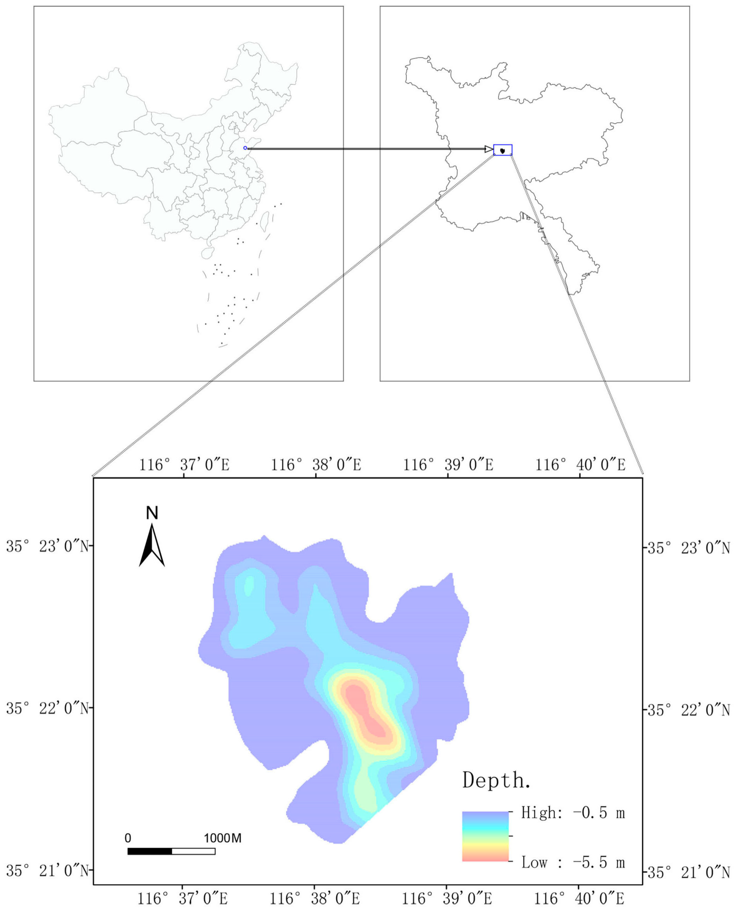
Figure 2.
Current ecological conditions in the Qianshiliying coal mining subsidence wetland.

Figure 3.
GIS(10.8) random point selection.

Figure 4.
Aerial photo of the drone.

Figure 5.
Schematic diagram of lake water level–lake area change rate.

Figure 6.
(a) Curve depicting the relationship between water level and the surface area of the Qianshiliying coal subsidence wetlands and (b) curve illustrating the relationship between water level and the rate of change in the surface area of the Qianshiliying coal subsidence wetlands.
Figure 6.
(a) Curve depicting the relationship between water level and the surface area of the Qianshiliying coal subsidence wetlands and (b) curve illustrating the relationship between water level and the rate of change in the surface area of the Qianshiliying coal subsidence wetlands.


Figure 7.
Model of water level versus coverage rate of aquatic vegetation.

Figure 8.
Illustrates the potential germination range of various aquatic plants in the Qianshiliying coal subsidence wetland.
Figure 8.
Illustrates the potential germination range of various aquatic plants in the Qianshiliying coal subsidence wetland.


Table 1.
Water Level Regulation Scheme for Different Stages of Aquatic Vegetation.
| Month | Growth Stage | Water Level Requirement | Water Level Range |
|---|---|---|---|
| February–March | Sprouting Period | Minimum Ecological Water Level | 32.50 m |
| April–May | Seedling Growth Period | Gradual increase in water level, with an increase rate of less than 0.5 m per month | 32.50~33.00 m |
| June–July | Growth and Spread Period | It is recommended to keep a high water level, however, the rate of escalation should not surpass 1.00 m monthly | 33.50~34.00 m |
| August–September | Maturity Period | Ensure the water level remains consistently high, being mindful not to surpass the designated cautionary mark for water levels. | 33.50~34.00 m |
| October–November | Seed Propagation Period | Slow decrease in water level, with a decrease rate not exceeding 3 cm per day | 32.60~33.10 m |
| December–January | Dormant Period | Maintain low water level | 32.50 m |
Disclaimer/Publisher’s Note: The statements, opinions and data contained in all publications are solely those of the individual author(s) and contributor(s) and not of MDPI and/or the editor(s). MDPI and/or the editor(s) disclaim responsibility for any injury to people or property resulting from any ideas, methods, instructions or products referred to in the content. |
© 2024 by the authors. Licensee MDPI, Basel, Switzerland. This article is an open access article distributed under the terms and conditions of the Creative Commons Attribution (CC BY) license (https://creativecommons.org/licenses/by/4.0/).
Share and Cite
MDPI and ACS Style
Luo, P.; Zhang, M.; Zhou, S. Research on the Reconstruction of Aquatic Vegetation Landscape in Coal Mining Subsidence Wetlands Based on Ecological Water Level. Water 2024, 16, 1339. https://doi.org/10.3390/w16101339
AMA Style
Luo P, Zhang M, Zhou S. Research on the Reconstruction of Aquatic Vegetation Landscape in Coal Mining Subsidence Wetlands Based on Ecological Water Level. Water. 2024; 16(10):1339. https://doi.org/10.3390/w16101339
Chicago/Turabian StyleLuo, Pingjia, Mengchu Zhang, and Shiyuan Zhou. 2024. "Research on the Reconstruction of Aquatic Vegetation Landscape in Coal Mining Subsidence Wetlands Based on Ecological Water Level" Water 16, no. 10: 1339. https://doi.org/10.3390/w16101339
Note that from the first issue of 2016, this journal uses article numbers instead of page numbers. See further details here.