
Defining Terminal Airspace Air Traffic Complexity Indicators Based on Air Traffic Controller Tasks

Department of Aeronautics, Faculty of Transport and Traffic Sciences, University of Zagreb, Vukelićeva 4, 10 000 Zagreb, Croatia
*
Author to whom correspondence should be addressed.
Aerospace 2024, 11(5), 367; https://doi.org/10.3390/aerospace11050367
Submission received: 8 April 2024
/
Revised: 30 April 2024
/
Accepted: 3 May 2024
/
Published: 6 May 2024
(This article belongs to the Special Issue Advances in Air Traffic and Airspace Control and Management (2nd Edition))
Abstract
:This paper focuses on terminal air traffic complexity indicators. By thorough analysis of previous research, the benefits and limitations of the existing terminal complexity models are identified. According to these findings, a new approach for determining terminal air traffic complexity indicators is proposed which assumes that terminal complexity could be determined based on approach air traffic controller (ATCO) tasks. The comprehensive list of general approach ATCO tasks was defined using a literature review and observation of training exercises, forming the basis for subsequent expert group workshops which enabled the acquisition of ATCOs’ knowledge data. Through these workshops, new approach ATCO tasks were additionally identified, and terminal complexity indicators were defined with airspace and traffic parameters. These new tasks and indicators present a novelty in this field of research since they incorporate ATCOs’ knowledge as the data input and consider various traffic scenarios, all types of traffic, weather conditions, and off-nominal situations.
1. Introduction
Air traffic controllers (ATCOs) prevent collisions between aircraft and expedite and maintain an orderly flow of air traffic [1]. The number of aircraft that ATCOs can control and manage safely and efficiently within a defined airspace and time [2] depends on the ATCO workload and is defined as airspace capacity. A high ATCO workload and a lack of airspace capacity are some of the crucial problems within Air Traffic Management (ATM). This problem results in traffic congestion and operational inefficiencies, delays, increased trajectory length, flight time, and fuel consumption, but can also decrease ATCO performance and endanger safety [3].
The main driver of ATCO workload is air traffic complexity [4]. It is defined as the difficulty of monitoring and managing a specific air traffic situation [5] and it can be explained as the ATCO’s subjective experience of how complex a certain traffic situation is [6]. Air traffic complexity influences the workload of every type of air traffic control service within different airspace structures: area control in en-route airspace, approach control in terminal airspace, and aerodrome control in the control zone. High air traffic complexity generates a high ATCO workload.
The importance of air traffic complexity is emphasized in the European ATM Master Plan which sets a need for an adequate air traffic complexity assessment tool as a part of future ground automation in the ATM system [7]. Additionally, the importance of improving flight efficiency during arrival and departure flights within the terminal airspace is pointed out. Since, due to the implementation of new procedures, additional changes are expected in terminal airspace, it will be necessary to check how it influences air traffic complexity.
A possible solution to solve the workload and capacity problems is the reduction of air traffic complexity. To enable complexity reduction, it is necessary to use an adequate complexity model or method to determine or assess complexity within en-route or terminal airspace.
There are many models and methods used to determine air traffic complexity but most of them are focused on the en-route phase of flight where airspace congestion problems are high, and it is necessary to find the optimum flow management solution to reduce ATCO workload and increase capacity. On the other hand, compared to en-route, there are few studies on terminal airspace complexity.
This paper is tackling terminal air traffic complexity and is focused on a completely different type of airspace structure compared to en-route airspace. Unlike in the en-route part, the terminal airspace complexity is highly dependent on terrain proximity, number of aerodromes covered, configuration of aerodrome manoeuvring area, airspace shape and dimensions, flight procedures design, and type of traffic. Sectors in terminal airspace can vary depending on the shape, size, type of traffic within the airspace (departing, arriving, overflying, or mixed), arrival and departure routes, minimum radar vectoring altitude, number of runways, etc. So, here, complexity arises from different aircraft interactions (i.e., traffic situations) but also from airspace structure and characteristics which influence aircraft trajectories. Difference in services for en-route and terminal traffic are emphasised in ATCO licences. ATCOs working in en-route sectors have licences for the en-route which do not permit them to work in terminal sectors and vice versa.
This research uses detailed data collection and preparation which enables the definition of various novel terminal complexity indicators, as well as approaching ATCO tasks based on expert knowledge input. The objective of the study is to define indicators and tasks that will be used later for the development of a terminal airspace air traffic complexity model which will calculate complexity in real-time but also in a pre-operational evaluation of simulation training exercises. This paper is organized in an additional four sections. In Section 2, an overview and the limitations of the various models and methodologies used to determine terminal air traffic complexity are presented. In Section 3, the methodology of preparation and acquiring of the expert knowledge data is described. Expert ATCOs participated in workshops where they answered in detail a prepared set of questions to thus acquire all the necessary data about their tasks and approach to ATCO operating procedures within the terminal airspace with departing, arriving, and overflying traffic, from a single runway operations aerodrome. In Section 4, thee acquired data are used for the definition of 33 novel complexity indicators. Complexity indicators are based on ATCO tasks, defined with parameters and selected for a type of traffic. At the end, in Section 5, the conclusion summarizes the conducted research and provides steps for future work.
2. Air Traffic Complexity Models and Indicators
Based on the current literature review, there are two main approaches for developing and evaluating a complexity model for en-route and terminal traffic. The first one is defining complexity indicators and building a model with or without the input of expert ATCO knowledge. Some complexity models which use expert ATCO knowledge are described in [8,9,10,11,12,13,14,15,16,17]. Other models which use complexity indicators are based on mathematical or statistical methods (e.g., [18,19,20,21,22,23,24,25]). On one hand, the latter make the development of the model easier since it is difficult to acquire ATCO input. On the other hand, such input is highly valuable information for the model’s development. As ATCOs are the ones that experience complexity, all other approaches to complexity determination are attempts to approximate its level considering the ATCOs’ subjective input [6]. Models with ATCOs’ input can be biased since ATCOs can be inconsistent upon deciding on complexity values. When observing the same traffic situation, two ATCOs could have different opinions about complexity levels, or one controller could give the same complexity values for two very different traffic situations. Inconsistency happens due to individual differences and raises a question of properly acquiring ATCOs’ complexity values.
The second approach in building an air traffic complexity model is focusing on the traffic and type of control. In such a way, complexity models can be developed solely for en-route traffic (e.g., [9,10,11,12,13,14,18,19,20,21,23,24,25]), terminal traffic (e.g., [15,17,22]) and combined (e.g., [16]). Models for en-route traffic are not suitable for determining terminal traffic complexity due to the significant distinctions in aircraft flight plans, airspace structure, and the control of air traffic. Models which have indicators developed both for en-route and terminal traffic mostly focus on en-route traffic and require indicator adjustment from area control to approach control which can be a time-consuming effort based on additional expert knowledge. The main reason for this adjustment is the significant difference in aircraft interactions within terminal airspace, where arriving traffic converges to the runway while reducing the speed and height during approach and preparing for landing, and departing traffic diverges from the runway with an increase of speed and height during departure. All this generates air traffic complexity that specifically influences the workload of the approach air traffic controller.
There are only a few studies related to aerodrome (e.g., [26,27]) and terminal (e.g., [15,22]) air traffic complexity. Models that focus on terminal complexity [15,16,17,22,28,29,30] are classified by years in Table 1, according to the complexity indicators’ characteristics. The characteristics in the columns inform about the indicators’ origin (expert ATCO input, reusing en-route indicators), type of traffic taken into consideration, weather and off-nominal conditions. Although weather can be defined as an off-nominal condition [31], in this classification it is separated for better presentation of the indicators.
Indicators based on expert ATCO input should better express complexity than those which do not use it because ATCOs subjectively experience complexity. In [15,17,30], indicators made for en-route air traffic are used for terminal air traffic. The lack of this approach is that the type of control, type of traffic, routes and airspace characteristic are different in en-route than in terminal airspace, so it is not appropriate for use in terminal complexity.
Terminal airspace can have different types of traffic. Traffic can be segregated for arriving or departing operations, but also mixed operations and overflights (total of six variations of traffic in a sector) can be used. Different aircraft interactions appear depending on the type of traffic in the terminal sectors. For such a reason, indicators that are made, e.g., only for arrivals, are not appropriate for expressing complexity in the terminal sector with, e.g., arrivals and overflights. All types of traffic are considered only in [16,30].
Weather can have a great influence on the complexity of terminal airspace. Its impact depends on the velocity, area of influence, and height range of wind and on adverse weather. It can increase complexity in a way that additional calculation for aircraft speed, route, altitude, and avoidance is necessary. For such a reason, it is not only important to include wind in complexity indicators but the adverse weather also. Weather influence is included in [16,30] only. In [16], weather is described as a traffic factor called Vmet which gives information about the percentage of the total volume of the sector in use affected by adverse meteorological conditions (severe icing, severe turbulence, cumulonimbus cloud, etc.). In [30], weather influence is described in a factor group called operational constraints. It contains, among other factors, restrictions on available airspace where the presence of adverse weather is included.
Off-nominal conditions mostly cannot be predicted but are practiced during ATCO training. Situations such as go around, emergency, military exercises, and radio failure increase the complexity of air traffic and should be considered when calculating complexity. Such situations are mentioned in [15,30]. In [30], off-nominal factors are the activation of special use airspace, aircraft in holding pattern, and possibly communication limitations (as no description is given). In [15], a variable of unusual or emergency events is defined with description of a restriction of airspace or tower restrictions. It can be seen from these factors that not all off-nominal conditions are included.
While papers [15,16,30] have covered almost all characteristics with complexity indicators, [15,30] use en-route indicators. Indicators from [16] are both for en-route and terminal and do not take into account off-nominal conditions. When observing columns in Table 1, it can be seen that most indicators are made with expert ATCO input and are focused on arriving and departing traffic. Indicators which cover off-nominal situations as well as weather are developed only in two papers.
During the examination of previous research in air traffic complexity, the benefits and limitations of complexity models based on type of traffic and ATCOs’ input are identified. In Figure 1, it can be seen why the current en-route complexity models are not applicable for terminal airspace and why current terminal complexity models require further improvement and development of new terminal complexity indicators. The benefits and limitations of (not) using ATCOs’ input are also presented in Figure 1.
The focus of this research is on developing complexity indicators that cover all important characteristics presented in Table 1. Indicators will be developed using expert ATCOs’ input; they will cover all types of traffic, weather, and off-nominal situations. Acquisition of the ATCOs’ knowledge is explained in the next section through the methodology.
3. Methodology
The research methodology consists of the three main phases in expert knowledge acquisition:
- Literature review and observation of training exercises—definition of ATCO tasks,
- First expert group workshops—definition of research questions about ATCO tasks,
- Second expert group workshops—acquisition of ATCOs’ knowledge data.
3.1. Literature Review and Observation of Training Exercises—Defining ATCO Tasks
As said earlier, the two main stages in defining the ATCO tasks were a literature review and observation of training exercises performed by ATCO trainees and instructors. The exercises were performed on the same terminal airspace where ATCOs from the expert group are licenced. The sector incorporates single runway operations and mixed traffic (departure, arrival, and overflight operations). Single runway operation is based on one single runway configuration of a manoeuvring area. Some aerodromes could have one single runway or more runways (parallel or non-parallel) used for landings and take-offs. In the case of more than one runway, segregated operations are established and performed (departure runway, arrival runway). In the case of one single runway, mixed operations are performed and runway have to be used for both landings and take-offs which could cause more complex traffic situations in TMA when identifying approach sequence and performing conflict detection and resolution. Because of this, in this research, we decided to use only single-runway operations.
Through the observation, special emphasis was placed on understanding the source of air traffic complexity, aircraft interactions, and airspace characteristics. Interactions activate a set of ATCO tasks that should be performed by ATCOs. The list of general air traffic controller tasks is made after the observation by using the literature which defines ATCO tasks [32,33,34]. Tasks that are singled out are related to aircraft interactions and do not enter the domain of technical tasks such as data input. Therefore, the indicators do not represent task load which includes interface, equipment, and procedural demands [34]. The list of general tasks (Table 2) is used later as a basis for the second round of workshops and as a starting point for defining terminal air traffic complexity indicators. General tasks are defined in a way that they are independent upon airspace characteristics but rely on traffic characteristics. Because of this, new complexity indicators that will be developed could be used on different terminal airspaces regardless of their shape and person controlling the airspace.
3.2. First Expert Group Workshops—Definition of Research Questions about ATCO Tasks
The first expert group gathered six researchers, ATM experts, four of whom were authors of this paper and two additional ATM experts with experience in air traffic complexity from the same institution. Several meetings and consultations in the form of a workshop were held with the aim to clarify or to detail ATCO tasks defined from the literature review and training exercises observations. The expert group considered different traffic situations and aircraft interactions and discussed the possible additional ATCO tasks that could impact air traffic complexity. For that reason, it was necessary to define additional research questions (Table 3) that would be used in the following phase of the research with ATCO experts and will enable comprehensiveness and clarification of the research problem, but also, to gather more detailed data for each ATCO task listed in Table 2.
3.3. Second Expert Group Workshops—Acquisition of ATCOs’ Knowledge Data
The second expert group was formed by four experienced licenced approach ATCOs, to which four ATM experts from the first group were subsequently added.
The focus of this second workshop was on ATCOs and their expert knowledge. The ATCOs were informed about the importance of the research and air traffic complexity was defined and explained in detail. They provided an approach ATC service in terminal airspace for mixed traffic (arrivals, departures, and overflights) from a single runway operations aerodrome. This fact is of great importance for acquiring all data necessary to develop complexity indicators that include mixed traffic operations. They would also give all relevant information about weather conditions that could influence different traffic situations and, also, explain off-nominal situations. Several workshops and consultations were held with the aim to acquire all necessary data for the detailed clarification of ATCO tasks.
During the workshops, ATCO experts provided professional explanation and consultation about their work with mixed traffic and analysed which situations were more complex and which tasks were used. They were encouraged to consider and discuss terminal airspace and traffic characteristics from different perspectives (licenced and other familiar airspace) and from executive and planner positions.
Afterwards, other expert group members used questions from Table 3 to detailly analyse and discuss ATCO tasks or traffic situations. Additionally, they had to focus on cognitive processes connected with the task activation which enabled a more detailed task description. ATCOs’ answers were noted during the workshops and voices recorded. This method helped the authors to recall all the details that are important for developing complexity indicators or understanding the ATCOs’ perspectives.
ATCOs agreed to be voice recorded during the workshops for easier data acquiring.
The focus of this part of the research was to additionally explain and quantify the tasks so they could be used as complexity indicators. It means that each complexity indicator should be defined in a form that would enable detection and be counted in an air traffic situation. The process of detecting complexity indicators requires the development of a customised algorithm and is an important part of air traffic complexity determination.
4. Results and Analysis
In this section, the results of the workshop will be given in the form of tables and additionally analysed.
4.1. Additional ATCO Tasks
ATCOs often explained how to resolve a specific task and conflict situation during the workshops. Other experts from the group had to return the focus back to the complexity in such situations. Deviation from the workshop topic is not surprising as the ATCOs’ job is focused on resolving tasks rather than considering them in terms of complexity. The first result of the workshops is an additional nine air traffic controller tasks. They arose during the workshop when ATCOs explained off-nominal conditions. A list of additional off-nominal tasks is presented in Table 4.
4.2. Complexity Indicators Based on ATCO Tasks
The second result of the workshops is a definition of 33 different complexity indicators (further in text, Indicator) with parameters in the context of airspace and traffic characteristics. Each of the 33 Indicators is defined as an ATCO task with parameters specified for the type of traffic. Parameters are determined so they could be used to detect and count ATCO tasks in air traffic situations. Indicators are separated into general, separational, and off-nominal for easier overview. Some of the Indicators require more detailed additional explanation of the parameters which will also enable easier understanding of other Indicators.
4.2.1. General Indicators
The definition of general Indicators with specific parameters, task description, and the type of traffic is shown in Table 5. These Indicators, together with separational Indicators, cover nominal situations for mixed traffic in terminal airspace with single runway operations.
There are tasks whose parameters differentiate due to the type of traffic but are counted as the same Indicator (e.g., Indicator 2 Initial call). Indicators such as Initial call can be divided to have three Indicators that could separately express the complexity of initial call for arrivals, departures, and overflights. Indicator 3 Screening of traffic has two options for activating parameters. The first one is the screening of all traffic where the number of screening pairs of aircraft is activated. The other one is the screening of traffic depending on all types of traffic which can be useful for expressing the relations between types of interactions. The options of parameters such as in Initial call and Screening of traffic enable flexibility and combinations when choosing indicators for complexity. Such features are welcomed when developing a complexity model and testing how each Indicator contributes to overall complexity. In the calculation of Indicator 3 for A-O, A-D, and D-O, subtraction of already calculated parameters nA, nO, and nD is made so that the same observed aircraft would not be counted more times.
Indicator 5 Clear for approach and transfer of communication will be explained with Figure 2 which represents a part of terminal airspace. When the arriving aircraft is in the marked blue area at altitude 5000 feet or less, then the task Clear for approach and transfer of communication is activated. A span of 100° and 10 nautical miles is taken to cover the significant area in which ATCOs give base and final headings. Final approach fix (FAF) is taken as a reference point from which the observed area is created.
4.2.2. Separational Indicators
There are seven Indicators related to aircraft separation (Table 6). Each of the Indicators has a specific type of traffic in interaction. Categorization in parameters is made to differentiate the complexity contribution of different interaction characteristics.
Indicator 7 Separation of arrivals on route is taken as an example for explaining the logic of Indicators 6–12. It concerns a pair of arriving aircraft. First parameter to be checked for activating the task is if the aircraft have less than 5 nautical miles difference upon their trajectory (the point where aircraft have distance less than 5 nautical miles for the first time is the closest point of conflict). If the difference is 5 nautical miles or higher, then there is no need to activate the task and observe other parameters for the task. A distance of 5 nautical miles is taken due to the standard separation of 5 nautical miles and 1000 ft. It could be increased to other values, depending on what is used as a base for trajectory prediction. The first categorisation is the time until the closest point of conflict. It has two categories of less than and more than 5 min. The limit of 5 min gives the indication of a more complex situation when there is less than 5 min to resolve the conflict.
The second categorisation is comparing wake turbulence categories where an aircraft that should come to the conflict point (a point where aircraft would cross trajectories or closest to it) later than the first one is observed as the second aircraft. For the comparison, there is categorisation of (a) same, (b) lighter, or (c) heavier. If aircraft are in the category (a) same, then current speeds are compared. If speeds would differentiate more than 10 knots, then there would be another categorisation of (I) same/slower or (II) faster. The third categorisation is deciding upon conflict or potential conflict. In conflict, actual and cleared altitudes/flight levels are observed. One aircraft is passing through the altitude/flight level of another aircraft. Potential conflict differentiates from conflict as the actual and exit altitude/flight level are observed. Thus, potential conflict should carry less complexity for the task.
The fourth categorisation is based on the available manoeuvring area for aircraft in conflict. It is an area calculated as a possible aircraft turn for 20° to the left and to the right from the current position for the next 15 min (with a 5-nautical-mile distance from other traffic, minimum radar vectoring altitude, and boundary—except for entry flights and active zone if any). The area is the same for each aircraft without any obstacles on the way and is noted as Amax. There are three categories (a) 0–30% Amax, (b) 30–65% Amax, and (c) 65–100% Amax. The most complex should be option a) where there is the least manoeuvring area for the aircraft. An example of the calculated area for three cases is presented in Figure 3. In the figure, observed aircraft and its route are marked black. Blue lines represent the aircraft position in t time for 20° to the left and to the right from the route. Green aircraft is the conflicting traffic to the black one. Red colour represents an area in which green aircraft must not enter as the separation minima is then lost. Once the aircraft distance from the obstacle or conflicting traffic is 5 nautical miles or less, it will deviate and change the heading. Amax is calculated as an area free from obstacles that does not contain the area coloured in red.
The traffic situation presented in Figure 4 is used as an example to explain the categorisation of parameters for Indicator 7 Separation of arrivals on route.
Categorisation explanation is given in Table 7 with the end results of task parameters for specific traffic situations. In order to choose the appropriate category, it is required to have the information about aircraft type and 4D trajectory. Using trajectory, the aircraft position at each time is known and can be used to determine conflicts, i.e., for first and third categorisation. Aircraft type and current speed are used for the second categorisation and fourth categorisation which require a separate algorithm as shown before. For large samples of traffic scenarios, it is more efficient to have an algorithm that detects tasks and categorises them. The result in Table 7 shows that the ATCO has a task of separating arriving traffic on route which are in potential conflict and should meet in less than 5 min, the second aircraft to conflict is a lower WTC, and both have the same available manoeuvring area available which is 30–65% Amax.
Indicator 10 Separation of departures has a fifth category in which an additional differentiation of aircraft category is made (“fast” or “slow” climber upon initial climb). The reason for the additional category is that during the workshops, ATCOs emphasised the importance of monitoring two succeeding aircraft that are of the same WTC but have very different climb performances. In a case when a second aircraft on departure has better climb performances, it could overtake the first aircraft and thus cause a loss of separation norm. For that reason, complexity is higher when the monitoring of such situation is required.
4.2.3. Off-Nominal Indicators
Off-nominal indicators contain information about common off-nominal, abnormal, and emergency situations (Table 8). As a change of aircraft plan in such indicators is not unusual, conflict detection requires new calculations. Previously, conflict is calculated based on the aircraft flight plan or updated data from the flight label. In case that aircraft is vectored or there is a change to the flight plan, e.g., missed approach or priority landing, the aircraft route should be changed. As there is no information about the ATCO plan for the whole route, a new route can only be predicted with uncertainty. For situations where a new route will not be calculated, Table 8 defines the options for conflict calculation. An example of an Indicator with a change of aircraft route is 22 Planning trajectory for aircraft in missed approach where aircraft in a missed approach should be planned in the traffic situation and guided towards the runway again. The task of Planning trajectory for aircraft in missed approach is activated and the aircraft is considered to be an arrival flight again. An exception in treating the flight as an arrival is that the conflicts have a new category that is called possible conflicts (or possible potential conflicts). It gives the indication of two aircraft possibly being in conflict using trajectory prediction with uncertainty or not considering new route.
Indicators are developed with parameters that can be changed according to the characteristics of terminal airspace, accuracy of trajectory prediction, or possibilities of the system that counts the tasks. For example, in a situation where trajectory prediction accuracy is not so good, the distance for conflict detection can be changed from 5 NM to 7 NM. In case when TMA is sectorized to segregate arrival or overflying traffic from departing traffic, then the departure tasks will be disregarded.
5. Conclusions and Future Work
In this paper, a new set of terminal air traffic complexity indicators is proposed. They are based on ATCOs’ tasks and input. First, a list of ATCO tasks was developed using the literature and observing ATCO trainees and instructors during exercises in terminal airspace which was used as a basis for the workshops with expert ATCOs. A set of questions for task analysis was prepared. During the workshops, approach ATCOs answered the questions and defined additional tasks. Workshops resulted in defining complexity indicators with airspace and traffic parameters that can be used to detect and count tasks in air traffic situations.
The proposed set of Indicators is the first one that includes ATCOs’ input, all types of traffic, weather, and off-nominal conditions. Future work will be focused on examining and using defined Indicators for the development of a terminal air traffic complexity model. Our goal is to explore whether such Indicators can express the complexity. Each Indicator should be given a weight value, because not all of them have the same impact on complexity. Overall complexity should depend on the Indictor weight that arises in the traffic situation.
The next step would be to develop an algorithm that detects the Indicators in the air traffic situation. The algorithm should have the trajectory information, flight plan data, and airspace characteristics as an input. Additionally, it should have information about the traffic situation such as runway closure or radiotelephony failure. A set of such air traffic situations should be developed which could provide the algorithm with all the necessary information. It should be considered whether there is an existing application or platform that would enable such data transfer or whether a new one is required. Air traffic situations should contain data that would cover the Indicators defined in this paper. Situations are the basis for ATCO tasks and should be given attention upon development. The extraction of Indicators with the algorithm would enable further development of the terminal air traffic complexity model.
Author Contributions
Conceptualization, T.J., B.J. and B.A.-F.; methodology, T.J. and B.J.; investigation, T.J., B.J., B.A.-F. and K.S.; resources, B.J.; writing—original draft preparation, T.J.; writing—review and editing, B.J., B.A.-F. and K.S.; visualization, T.J.; supervision, B.J.; project administration, T.J. All authors have read and agreed to the published version of the manuscript.
Funding
This research received no external funding.
Data Availability Statement
The original contributions presented in the study are included in the article; further inquiries can be directed to the corresponding author/s.
Conflicts of Interest
The authors declare no conflicts of interest.
References
- European Union Aviation Safety Agency. Easy Access Rules for Standardised European Rules of the Air (SERA). Available online: https://www.easa.europa.eu/en/document-library/easy-access-rules/online-publications/easy-access-rules-standardised-european?page=15 (accessed on 25 April 2024).
- Flynn, G.; Benkouar, A.; Christien, R. Pessimistic Sector Capacity Estimation; EEC note; EUROCONTROL Experimental Centre: Brétigny-sur-Orge, France, 2003. [Google Scholar]
- Radišić, T.; Andraši, P.; Novak, D.; Juričić, B.; Antulov-Fantulin, B. Air traffic complexity as a source of risk in ATM. In Risk Assessment in Air Traffic Management; Perez Castan, J.A., Rodriguez Sanz, A., Eds.; IntechOpen: London, UK, 2020; pp. 63–89. [Google Scholar]
- Mogford, R.H.; Guttman, J.; Morrow, S.; Kopardekar, P. The Complexity Construct in Air Traffic Control: A Review and Synthesis of the Literature; Technical note; Federal Aviation Administration: Springfield, VA, USA, 1995.
- Meckiff, C.; Chone, R.; Nicolaon, J.P. The tactical load smoother for multi-sector planning. In Proceedings of the USA/Europe Air Traffic Management R&D Seminar, Orlando, FI, USA, 1–4 December 1998. [Google Scholar]
- Antulov-Fantulin, B.; Juričić, B.; Radišić, T.; Çetek, C. Determining Air Traffic Complexity—Challenges and Future Development. Promet 2020, 32, 475–485. [Google Scholar] [CrossRef]
- SESAR Joint Undertaking. Digitalising Europe’s Aviation Infrastructure; European ATM Master Plan; Publications Office of the European Union: Luxembourg, 2020. [Google Scholar]
- Laudeman, I.V.; Shelden, S.G.; Branstrom, R.; Brasil, C.L. Dynamic Density: An Air Traffic Management Metric; Technical memorandum; NASA: Ames Research Center: Moffett Field, CA, USA, 1998.
- Kopardekar, P.; Magyarits, S. Dynamic density: Measuring and predicting sector complexity. In Proceedings of the 21st Digital Avionics Systems Conference, Irvine, CA, USA, 27–31 October 2002. [Google Scholar]
- Kopardekar, P.H.; Schwartz, A.; Magyarits, S.; Rhodes, J. Airspace Complexity Measurement: An Air Traffic Control Simulation Analysis. Int. J. Ind. Eng. 2009, 16, 61–70. [Google Scholar]
- Masalonis, A.; Callaham, M.; Wanke, C. Dynamic Density and Complexity Metrics for Real-Time Traffic Flow Management; The MITRE Corporation: McLean, VA, USA, 2003. [Google Scholar]
- Klein, A.; Rodgers, M.; Leiden, K. Simplified dynamic density: A metric for dynamic airspace configuration and NextGen analysis. In Proceedings of the 28th Digital Avionics Systems Conference (DASC): Modernization of Avionics and ATM-perspectives from the Air and Ground, Orlando, FL, USA, 25–29 October 2009. [Google Scholar] [CrossRef]
- Andraši, P.; Radišić, T.; Novak, D.; Juričić, B. Subjective Air Traffic Complexity Estimation Using Artificial Neural Networks. Promet 2019, 31, 377–386. [Google Scholar] [CrossRef]
- Radišić, T.; Novak, D.; Juričić, B. Reduction of Air Traffic Complexity Using Trajectory-Based Operations and Validation of Novel Complexity Indicators. IEEE Trans. Intell. Transp. Syst. 2017, 18, 3038–3048. Available online: https://ieeexplore.ieee.org/stamp/stamp.jsp?arnumber=7879303 (accessed on 23 March 2024).
- Dervic, A.; Rank, A. ATC complexity measures: Formulas measuring workload and complexity at Stockholm TMA. Master’s Thesis, Linköping University, Linköping, Sweden, 2015. [Google Scholar]
- Diaconu, A.G.; Stancu, V.; Pleter, O.T. Air traffic complexity metric for en-route and terminal areas. UPB Sci. Bull. D Mech. Eng. 2014, 76, 13–24. [Google Scholar]
- Medianto, R.; Adinda, N.M.; Jenie, Y.I.; Pasaribu, H.M.; Muhammad, H. Terminal Control Area Complexity Measurement Using Simulation Model. IIUM Eng. J. 2023, 24, 199–212. [Google Scholar] [CrossRef]
- EUROCONTROL. Complexity Metrics for ANSP Benchmarking Analysis; Report; Performance Review Commission: Brussels, Belgium, 2006. [Google Scholar]
- Wee, H.J.; Lye, S.W.; Pinheiro, J.P. A Spatial, Temporal Complexity Metric for Tactical Air Traffic Control. J. Navig. 2018, 71, 1040–1054. [Google Scholar] [CrossRef]
- Delahaye, D.; Puechmorel, S. Air traffic complexity: Towards intrinsic metrics. In Proceedings of the third USA/Europe Air Traffic Management R & D Seminar, Napoli, Italy, 3–6 June 2000. [Google Scholar]
- Wang, H.; Song, Z.; Wen, R. Modeling Air Traffic Situation Complexity with a Dynamic Weighted Network Approach. J. Adv. Transp. 2018, 2018, 5254289. [Google Scholar] [CrossRef]
- Netjasov, F.; Janić, M.; Tošić, V. Developing a generic metric of terminal airspace traffic complexity. Transportmetrica 2011, 7, 369–394. [Google Scholar] [CrossRef]
- Juntama, P.; Delahaye, D.; Chaimatanan, S.; Alam, S. Hyperheuristic approach based on reinforcement learning for air traffic complexity mitigation. J. Aerosp. Inf. Syst. 2022, 19, 633–648. [Google Scholar] [CrossRef]
- Wang, H.; Xu, P.; Zhong, F. Modeling and Feature Analysis of Air Traffic Complexity Propagation. Sustainability 2022, 14, 11157. [Google Scholar] [CrossRef]
- Li, B.; Du, W.; Zhang, Y.; Chen, J.; Tang, K.; Cao, X. Deep Unsupervised Learning Approach for Airspace Complexity Evaluation. IEEE Trans. Intell. Transp. Syst. 2022, 23, 11739–11751. [Google Scholar] [CrossRef]
- Koros, A.; Rocco, P.D.; Panjwani, G.; Ingurgio, V.; D’Arcy, J.F. Complexity in Air Traffic Control Towers: A Field Study; Technical Note; FAA: Stephens City, VA, USA, 2003. [Google Scholar]
- Krstić Simić, T.; Babić, O. Airport traffic complexity and environment efficiency metrics for evaluation of ATM measures. J. Air Transp. Manag. 2015, 42, 260–271. [Google Scholar] [CrossRef]
- Malakis, S.; Psaros, P.; Kontogiannis, T.; Kontogiannis, T.; Malaki, C. Classification of air traffic control scenarios using decision trees: Insight from a field study in terminal approach radar environment. Cogn. Technol. Work 2020, 22, 159–179. [Google Scholar] [CrossRef]
- Yang, L.; Yin, S.; Hu, M.; Han, K.; Zhang, H. Empirical exploration of air traffic and human dynamics in terminal airspaces. Transp. Res. Part C Emerg. 2017, 84, 219–244. [Google Scholar] [CrossRef]
- Histon, J.M.; Hansman, R.J.; Cummings, M.; Weigel, A. Mitigating Complexity in Air Traffic Control: The Role of Structure-Based Abstractions; Report based on Doctoral Dissertation; MIT: Cambridge, MA, USA, 2008. [Google Scholar]
- Sawyer, M.W.; Berry, K.A.; Austrian, E.M. Assessing the Effects of Off-Nominal Conditions on NextGen Air Traffic Control Operations. In Proceedings of the 17th International Symposium on Aviation Psychology, Dayton, OH, USA, 6–9 May 2013. [Google Scholar]
- Brout, M.; Grau, J.Y.; Hearing, H. Task Load Generated by Frequent Sector Changes for Aircrews and Controllers State-of-the-Art Literature Study; EEC Note; EUROCONTROL: Brétigny-sur-Orge Cedex, France, 2008. [Google Scholar]
- Baumgartner, M. Critical Incident Stress Management in Air Traffic Control; EEC Note; EUROCONTROL: Brétigny-sur-Orge Cedex, France, 2004. [Google Scholar]
- Hilburn, B. Cognitive Complexity in Air Traffic Control—A Literature Review; EEC Note; EUROCONTROL: Brétigny-sur-Orge Cedex, France, 2004. [Google Scholar]
Figure 1.
Identified benefits and limitations of developed air traffic complexity models based on type of traffic and control, and ATCOs’ input.
Figure 1.
Identified benefits and limitations of developed air traffic complexity models based on type of traffic and control, and ATCOs’ input.

Figure 2.
Blue area is used for calculating Indicator 5.

Figure 3.
Available manoeuvring area: (a) 0–30% Amax, (b) 30–65% Amax, and (c) 65–100% Amax.
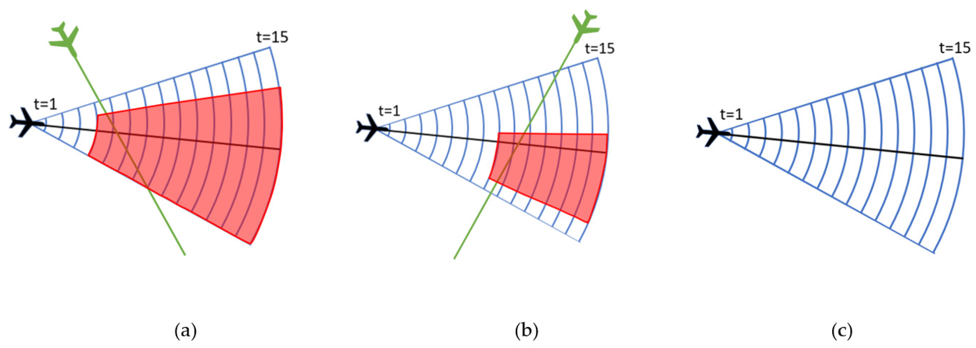
Figure 4.
Example of traffic situation for extraction of parameters for Indicator Separation of arrivals on route.
Figure 4.
Example of traffic situation for extraction of parameters for Indicator Separation of arrivals on route.


Table 1.
Complexity indicators characteristics.
| Expert ATCO Input | En-Route Indicators | Type of Traffic | Weather | Off-Nominal Conditions | |||
|---|---|---|---|---|---|---|---|
| Arrivals | Departures | Overflights | |||||
| [30] *, 2008 | 🗸 | 🗸 | 🗸 | 🗸 | 🗸 | 🗸 | 🗸 |
| [22], 2011 | 🗸 | 🗸 | |||||
| [16] *, 2014 | 🗸 | 🗸 | 🗸 | 🗸 | 🗸 | ||
| [15], 2015 | 🗸 | 🗸 | 🗸 | 🗸 | 🗸 | ||
| [29], 2017 | 🗸 | 🗸 | |||||
| [28], 2019 | 🗸 | 🗸 | 🗸 | ||||
| [17], 2023 | 🗸 | 🗸 | 🗸 | 🗸 | |||
* Indicators both for en-route and terminal air traffic.
Table 2.
General ATCO tasks for terminal air traffic.
| Task Number | Task Description |
|---|---|
| 1 | Planning route/co-ordination |
| 2 | Initial call |
| 3 | Screening of traffic |
| 4 | Transfer of communication for departures and overflights |
| 5 | Clear for approach and transfer of communication |
| 6 | Separation of aircraft in approach sequence on Final Approach Fix |
| 7 | Separation of arrivals |
| 8 | Separation of arrivals from departures |
| 9 | Separation of arrivals from overflights |
| 10 | Separation of departures |
| 11 | Separation of departures and overflights |
| 12 | Separation of overflights |
| 13 | Vectoring aircraft through airspace for separation or sequence |
| 14 | Guide aircraft with priority landing (hospital, emergency, hijack, etc.) |
| 15 | Adjust route for arrivals due to priority landing |
| 16 | Monitor aircraft with communication failure |
| 17 | Separate conflicting traffic from flight with radiotelephony failure |
| 18 | Include aircraft from holding pattern in traffic |
| 19 | Compensate wind influence on aircraft trajectory |
| 20 | Avoiding adverse weather |
| 21 | Avoiding active zones |
| 22 | Planning trajectory for aircraft in missed approach |
| 23 | Guide approach training flight |
| 24 | Separate aircraft with additional separation norm (military jet, state, etc.) |
Table 3.
List of general questions.
| Question Number | Question |
|---|---|
| 1 | Do you think that this task adds to the complexity of traffic situation? |
| 2 | When and under what conditions does the task appear? |
| 3 | Can you give an example of a traffic situation when this task appears? |
| 4 | In what conditions can the task be even more complex? |
| 5 | When do you start perceiving the task? |
| 6 | Do aircraft in the task interact with other aircraft or obstacles? |
| 7 | If there is a conflict between aircraft, how do you decide if it is more or less complex? Under what parameters? |
| 8 | Is wake turbulence category important information for this task? |
| 9 | What is an important point/time/position for the aircraft in the task? |
| 10 | How do you perceive the aircraft and airspace around it when the task appears? |
| 11 | With what condition does this task require immediate reaction? |
| 12 | When does the task end? |
| 13 | Does it contain subtasks? Can you name them? |
| 14 | What are important parameters of the task? |
| 15 | How do you handle the task? |
Table 4.
Additional ATCO tasks defined during the workshops.
| Task Number | Task Description |
|---|---|
| 1 | Planning arrivals for low visibility procedure |
| 2 | Handling high aircraft |
| 3 | Co-ordination required for aircraft not able to climb/descent to required flight level |
| 4 | Co-ordination required for two aircraft coming at the same entry point within 2 min and at the same flight level/altitude |
| 5 | Planning new route due to runway change |
| 6 | Separate arriving aircraft until runway opened (cleaning snow, removing debris, …) |
| 7 | Separate arriving aircraft after the runway is opened |
| 8 | Guide aircraft for navigational aid calibration |
| 9 | Separate calibration flight from arrivals or departures/overflights |
Table 5.
General Indicators.
| Complexity Indicator | Task Description | Type of Traffic 1 | Parameters |
|---|---|---|---|
| 1 | Planning route/co-ordination | A | Task is active 15 up to 4 min before the aircraft enters the airspace |
| D | Task is active 15 min before departure up to 1 minute before entering the airspace | ||
| O | Task is active 15 up to 4 min before the aircraft enters the airspace | ||
| 2 | Initial call | A | Task is active 4 min before the aircraft enters the airspace until the entrance |
| D | Task is active 1 minute before the aircraft enters the airspace until the entrance | ||
| Omin | Task is active 4 min before the aircraft enters the airspace until the entrance | ||
| 3 | Screening of traffic (first option) | ALL | where n is the number of observed aircraft |
| Screening of traffic (second option) | A-A | where n1 is the number of arrivals | |
| D-D | where n2 is the number of departures | ||
| O-O | where n3 is the number of overflights | ||
| A-O | where n4 is the number of arrivals and overflights | ||
| A-D | where n5 is the number of arrivals and departures | ||
| D-O | where n6 is the number of departures and overflights | ||
| 4 | Transfer of communication for departures and overflights | D | Task is active 3 min before aircraft exits the airspace |
| O | |||
| 5 | Clear for approach and transfer of communication | A | Task is active when aircraft is 10 NM 2 and in 100° from FAF 3 opposite of the runway with altitude 5000 feet or less |
1 A, D, and O represent arrival, departure, and overflight. 2 Nautical miles. 3 Final Approach Fix.
Table 6.
Separational Indicators.
| Complexity Indicator | Task Description | Type of Traffic | Parameters | Categories |
|---|---|---|---|---|
| 6 | Separation of aircraft in approach sequence on FAF | A | First categorization—task is active when aircraft have a difference in minutes until FAF | (a) <2 min |
| (b) 2–5 min | ||||
| Second categorisation—type of conflict | (a) conflict | |||
| (b) potential conflict | ||||
| Third categorisation—time until first aircraft to FAF | (a) <5 min | |||
| (b) ≥5 min | ||||
| Fourth categorisation—comparison of aircraft WTC 1 for second aircraft | (a) Same (if speed difference >10 knots than categorise into I) same/slower or II) faster) | |||
| (b) lighter | ||||
| (c) heavier | ||||
| Fifth categorisation—available manoeuvring area: the free area for manoeuvring in case of 20° turn to the left and to the right from the current position for the next 15 min (calculated as 5 NM distance from other traffic, MRVA 2, boundary (except for entry flights) or active zone) | (a) 0–30% Amax | |||
| (b) 30–65% Amax | ||||
| (c) 65–100% Amax | ||||
| 7 | Separation of arrivals on route (in a case that for the same two arrivals, task 6 and 7, are recognized, then count only task 7) | A | Task is active when aircraft have <5 NM distance upon trajectories (closest point of conflict in time) | |
| First categorisation—time until the closest point of conflict | (a) <5 min | |||
| (b) ≥5 min | ||||
| Second categorisation—compare second aircraft (to conflict point) based on WTC | (a) same (if speed difference >10 knots than categorise into I) same/slower or II) faster) | |||
| (b) lighter | ||||
| (c) heavier | ||||
| Third categorisation—type of conflict | (a) conflict | |||
| (b) potential conflict | ||||
| Fourth categorisation—available manoeuvring area: the free area for manoeuvring in case of 20° turn to the left and to the right from the current position for the next 15 min (calculated as 5 NM distance from other traffic, MRVA 2, boundary (except for entry flights) or active zone) | (a) 0–30% Amax | |||
| (b) 30–65% Amax | ||||
| (c) 65–100% Amax | ||||
| 8 | Separation of arrivals from departures | A–D | Task is active when aircraft have <5 NM distance upon trajectories (the closest point of conflict in time) and if have 1st category defined | |
| First categorisation—check if there is potential conflict or conflict based on flight levels/altitude upon route (if no, do not activate task) | (a) conflict | |||
| (b) potential conflict | ||||
| Second categorisation—time until the closest point of conflict | (a) <5 min | |||
| (b) ≥5 min | ||||
| Third categorisation—Available manoeuvring area—free area for manoeuvring in case of 20° turn to the left and to the right from the current position for next 15 min (calculated as 5 NM distance from other traffic, MRVA 2, boundary (except for entry flights) or active zone) | (a) 0–30% Amax | |||
| (b) 30–65% Amax | ||||
| (c) 65–100% Amax | ||||
| 9 | Separation of arrivals from overflights | A-O | Task is active when aircraft have <5 NM distance upon trajectories (the closest point of conflict in time) and if there is potential conflict or conflict based on flight levels/altitude upon route | |
| First categorisation—potential conflict or conflict based on flight levels/altitude upon route | (a) conflict | |||
| (b) potential conflict | ||||
| Second categorisation—time until the closest point of conflict | (a) <5 min | |||
| (b) ≥5 min | ||||
| Third categorisation—available manoeuvring area: the free area for manoeuvring in case of 20° turn to the left and to the right from the current position for next 15 min (calculated as 5 NM distance from other traffic, MRVA 2, boundary (except for entry flights) or active zone) | (a) 0–30% Amax | |||
| (b) 30–65% Amax | ||||
| (c) 65–100% Amax | ||||
| 10 | Separation of departures | D-D | Task is active when aircraft have <5 NM distance upon trajectories (the closest point of conflict in time) | |
| First categorisation—type of conflict | (a) conflict | |||
| (b) potential conflict | ||||
| Second categorisation—check if second aircraft on the same route has higher WTC category | (a) higher WTC category | |||
| (b) lower WTC category | ||||
| Third categorsisation—time until the closest point of conflict | (a) <5 min | |||
| (b) ≥5 min | ||||
| Fourth categorisation—available manoeuvring area: the free area for manoeuvring in case of 20° turn to the left and to the right from the current position for the next 15 min (calculated as 5 NM distance from other traffic, MRVA 2, boundary (except for entry flights) or active zone) | (a) 0–30% Amax | |||
| (b) 30–65% Amax | ||||
| (c) 65–100% Amax | ||||
| 5th categorization—check if 2nd aircraft upon initial climb is “fast” or “slow” climber | (a) “fast” climber | |||
| (b) “slow” climber | ||||
| 11 | Separation of departures and overflights | D-O | Task is active when aircraft have <5 NM distance upon trajectories (the closest point of conflict in time) | |
| First categorisation—type of conflict (if no conflict, do not activate the task) | (a) conflict | |||
| (b) potential conflict | ||||
| Second categorisation—time until conflict | (a) <5 min | |||
| (b) ≥5 min | ||||
| Third categorisation—if aircraft have the same exit point and level then check if second aircraft to exit is higher WTC category | (a) higher WTC category | |||
| (b) lower WTC category | ||||
| Fourth categorization—available manoeuvring area: the free area for manoeuvring in case of 20° turn to the left and to the right from the current position for next 15 min (calculated as 5 NM distance from other traffic, MRVA 2, boundary (except for entry flights) or active zone) | (a) 0–30% Amax | |||
| (b) 30–65% Amax | ||||
| (c) 65–100% Amax | ||||
| 12 | Separation of overflights | O-O | Task is active when aircraft have <5 NM distance upon trajectories (the closest point of conflict in time) | |
| First categorisation—type of conflict | (a) conflict | |||
| (b) potential conflict | ||||
| Second categorisation—if aircraft have the same exit point and level then check if second aircraft to exit is higher WTC category | (a) higher WTC category | |||
| (b) lower WTC category | ||||
| Third categorisation—time until conflict | (a) <5 min | |||
| (b) ≥5 min | ||||
| Fourth categorisation—available manoeuvring area: the free area for manoeuvring in case of 20° turn to the left and to the right from the current position for next 15 min (calculated as 5 NM distance from other traffic, MRVA 2, boundary (except for entry flights) or active zone) | (a) 0–30% Amax | |||
| (b) 30–65% Amax | ||||
| (c) 65–100% Amax | ||||
1 Wake Turbulence Category. 2 Minimum Radar Vectoring Altitude.
Table 7.
Parameter categorisation of Indicator Separation of arrivals on route.
| Condition/Categorisation | Explanation | Result |
|---|---|---|
| Task is active when aircraft have <5 NM distance upon trajectories (the closest point of conflict in time) | Condition satisfied: aircraft have <5 NM distance at some point in time upon their trajectory -> move to categorisation | Activate task with parameters: |
| First categorization—time until the closest point of conflict is (a) <5 or (b) ≥5 min | Time until the closest point of conflict is <5 min (calculated based on aircraft distance until the closest point of conflict and speed) | <5 min |
| Second categorization—compare second aircraft (to conflict point) based on WTC (a) same, (b) lighter, (c) heavier, and if aircraft are in category (a) same, then compare speed; if aircraft speeds are >10 knots difference then categorise into (I) same/slower or (II) faster | Second aircraft to conflict point is CTN520 based on speed which is M WTC and thus lighter than AUA387 which is H WTC (AUA387 is faster with 250 knots while CTN520 has 230 knots) | Lighter |
| Third categorisation—aircraft are in conflict or potential conflict | Aircraft are in potential conflict as aircraft have more than 1000-feet difference and are approved for descent at different altitudes but have the same exit altitude | Potential conflict |
| Fourth categorization—manoeuvring area (a) 0–30% Amax, (b) 30–65% Amax, (c) 65–100% Amax | Manoeuvring area for the first and secnd aircraft is in category (b) 30–65%S max | First aircraft -> 30–65% Amax Second aircraft -> 30–65% Amax |
Table 8.
Off-nominal Indicators.
| Complexity Indicator | Task Description | Type of Traffic | Parameters |
|---|---|---|---|
| 13 | Vectoring aircraft through airspace for separation or sequence | ALL | Task is active for aircraft which are vectored for separation or optimising trajectory but not due to active zone or adverse weather. If a new route is given in the scenario, then calculate possible conflicts according to it. If no information about a new route, then change conflicts to possible conflicts (from old route) and screen other traffic that could be conflicts (according to flight level crossing). |
| 14 and 15 | Guide aircraft with priority landing (hospital, emergency, hijack, etc.) and adjust route for arrivals due to priority landing | A | If the aircraft is first on FAF, then activate just the task Guide aircraft with priority landing. If the aircraft is not first on FAF but with a distance to FAF (direct distance from the current position or entry point +2 or 5 NM depending on required turn to base, counting reducing speed), it can be on FAF before other flights, then activate task Adjust route to those arriving flights. |
| 16 and 17 | Monitor aircraft with radiotelephony failure and separate conflicting traffic from flight with radiotelephony failure | ALL | Task Monitor aircraft with radiotelephony failure is active for aircraft with radiotelephony failure. Task Separate conflicting traffic from the one with radiotelephony failure is active for conflicting traffic. If the aircraft has a different route than originally planned, then calculate conflicting traffic for the next 7 min and then back to originally planned. |
| 18 | Include aircraft from holding pattern in traffic | ALL | Task is active for each aircraft in holding pattern. |
| 19 | Compensate wind influence on aircraft trajectory | ALL | Task is active for aircraft in conflict or arrivals in sequence that have wind on route ≥10 knots, choose category head/tail/cross wind. |
| 20 | Avoiding adverse weather | ALL | If weather data are available, check if route goes through adverse weather or closer than 5 NM. If yes, then activate task. If weather data are not available, then check which aircraft requests avoiding and calculate the task for that aircraft then activate Avoiding for other aircraft that have the same route. If a new route (rerouted from ATCO) is available, calculate new possible conflicts. If a new route is not available, change conflicts to possible conflicts (from old route) and screen other traffic that could be conflicts (according to flight level crossing). |
| 21 | Avoiding active zone | ALL | Check if aircraft route enters active zone, or is 5 NM or less close to it. If yes, then activate the task. If a new route (rerouted from ATCO) is available, calculate new possible conflicts. If a new route is not available, change conflicts to possible conflicts (from old route) and screen other traffic that could be conflicts (according to flight level crossing). |
| 22 | Planning trajectory for aircraft in missed approach | A | Task is active for aircraft going around. If a new route available, calculate aircraft as arrival and define possible conflicts. If a new route is not available, change conflicts to possible conflicts (from old route) and screen other traffic that could be conflicts (according to flight level crossing). |
| 23 | Guide approach training flight | A | Task is active for each approach training flight. |
| 24 | Separate aircraft with additional separation norm (military jet, state, etc.) | ALL | Task is active for aircraft which has a need for additional separation norm until it leaves the airspace. Calculate conflicts and potential conflicts with 2000 feet separation for that aircraft. |
| 25 | Planning arrivals for low visibility procedure | A | Check if expected distance between pair of aircraft on FAF is <15 NM in low visibility. If yes, then activate task. In case the distance between a pair of aircraft is >15 NM, but the average distance of the pair of aircraft planning to land before is <15 NM, then activate task. |
| 26 | Handling high aircraft | A and O | Task is active for arrival or overflight coming too high and will be 5000 feet or more above the required entry level. |
| 27 | Co-ordination required for flight level allocation scheme | ALL | Task is active for aircraft not able to climb/descend to required flight level. |
| 28 | Co-ordination required due to conflict on entry point | ALL | Task is active for two aircraft coming at the same entry point within 2 min and at the same flight level/altitude. |
| 29 | Planning new route due to runway change | A and D | For arrivals currently in the airspace, activate task only if tC − tFAF < 0, tC—time of runway change, tFAF-time of aircraft on FAF. For arrivals outside airspace, activate if tENTRY ≤ 10 min (then revise route), tENTRY—time of aircraft entering the airspace. For departures, if tC ≤ 15 min and tDEP ≤ 15 then calculate tC—tDEP, if ≤0 then activate task, tDEP—time of aircraft departure Then, activate possible conflicts if a new route is available; if no new route, change conflicts (from old route) to possible conflicts and screen aircraft with other traffic if there could be conflicts (according to flight level crossing). |
| 30 and 31 | Separate arriving aircraft until runway is opened (cleaning snow, removing debris…) and Separate arriving aircraft after the runway is opened | A | When RWY is closed, activate task for separating each arrival in airspace and 15 NM from airspace. When RWY is opened, activate the task of separating after the runway is opened until last arriving aircraft counted is cleared for approach. |
| 32 and 33 | Guide aircraft for navigational aid calibration and Separate calibration flight from arrivals or departures/overflights | ALL | Guiding the aircraft task is active for flight for navigational aid calibration. Each arrival is checked for conflict, and if conflict, then activate separate from arrivals. Each departure and overflight is checked for conflict, and if conflict, then activate separate from departure or overflights. |
Disclaimer/Publisher’s Note: The statements, opinions and data contained in all publications are solely those of the individual author(s) and contributor(s) and not of MDPI and/or the editor(s). MDPI and/or the editor(s) disclaim responsibility for any injury to people or property resulting from any ideas, methods, instructions or products referred to in the content. |
© 2024 by the authors. Licensee MDPI, Basel, Switzerland. This article is an open access article distributed under the terms and conditions of the Creative Commons Attribution (CC BY) license (https://creativecommons.org/licenses/by/4.0/).
Share and Cite
MDPI and ACS Style
Jurinić, T.; Juričić, B.; Antulov-Fantulin, B.; Samardžić, K. Defining Terminal Airspace Air Traffic Complexity Indicators Based on Air Traffic Controller Tasks. Aerospace 2024, 11, 367. https://doi.org/10.3390/aerospace11050367
AMA Style
Jurinić T, Juričić B, Antulov-Fantulin B, Samardžić K. Defining Terminal Airspace Air Traffic Complexity Indicators Based on Air Traffic Controller Tasks. Aerospace. 2024; 11(5):367. https://doi.org/10.3390/aerospace11050367
Chicago/Turabian StyleJurinić, Tea, Biljana Juričić, Bruno Antulov-Fantulin, and Kristina Samardžić. 2024. "Defining Terminal Airspace Air Traffic Complexity Indicators Based on Air Traffic Controller Tasks" Aerospace 11, no. 5: 367. https://doi.org/10.3390/aerospace11050367
Note that from the first issue of 2016, this journal uses article numbers instead of page numbers. See further details here.