
Traditional Village Morphological Characteristics and Driving Mechanism from a Rural Sustainability Perspective: Evidence from Jiangsu Province

Abstract
:1. Introduction
1.1. Background
1.2. Literature Review
1.2.1. Research on the Interaction between Rural Sustainability and Morphology
1.2.2. Analysis of Village Morphology Indicators
1.3. Research Gaps and Issues
2. Materials and Methods
2.1. Study Area: Jiangsu Province, China
- (1)
- The Reason for Choosing Jiangsu
- (2)
- Principles for Selecting Case Villages
2.2. Research Steps and Technical Roadmap
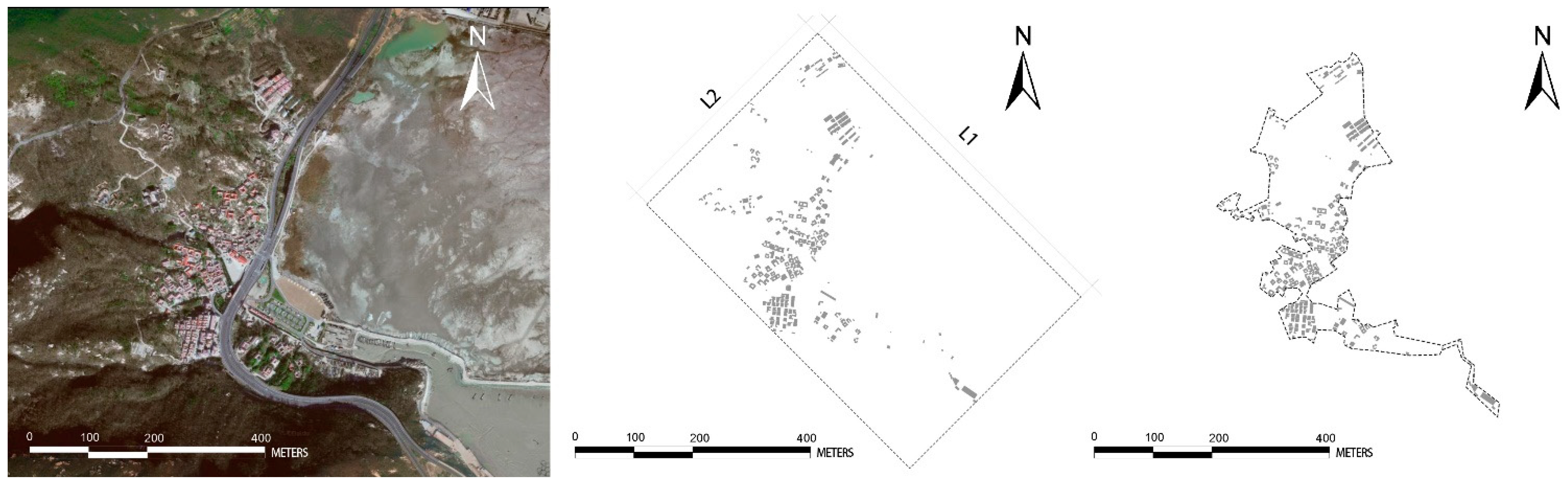
2.3. Research Methods: Morphological Indicator Calculation Model
2.3.1. Morphological Quantitative Calculation
- (1)
- Aspect Ratio (λ)
- (2)
- Building Density (M)
2.3.2. ArcGIS Spatial Analysis
- (1)
- Kernel Density Estimation (KDE)
- (2)
- Nearest Neighbor Index (NNI)
- (3)
- Getis–Ord Gi*
2.3.3. GeoDetector
2.4. Indicator Selection and Data Sources
3. Results
3.1. Spatial Pattern Analysis
3.1.1. Traditional Village Spatial Pattern (Y1)
3.1.2. Morphological Characteristics of Different Cities
3.2. Types of Morphological Indicators
3.2.1. Distribution Analysis of Morphological Indicators (Y2 and Y3)
3.2.2. Spatial Characteristics of Aspect Ratio (Y2)
3.2.3. Spatial Characteristics of the Building Density Indicator (Y3)
3.3. Spatial Differences in Rural Sustainability
3.3.1. Rural Sustainable Development in Jiangsu from Multiple Perspectives
- (1)
- Environmental System
- (2)
- Economic System
- (3)
- Social System


3.3.2. Spatial Distribution of 17 SDGs
3.4. Influencing Factors and Impact Mechanisms
3.4.1. The Importance and Nature of Factors
3.4.2. The Spatial Effects of Direct Influencing Factors
3.4.3. Interaction Detector for Driving Factors
4. Discussion
4.1. High Spatial Pattern Heterogeneity, High Correlation, and Clustering of Morphological Indicators
4.2. Interpreting the Correlation Mechanism between Traditional Villages’ Spatial Morphology and Sustainability (Driving Mechanisms)
4.3. Policy Design Value
5. Conclusions
- (1)
- The spatial distribution patterns and indicator characteristics of traditional villages in Jiangsu Province are of great significance in revealing the operating mechanisms of sustainable rural development in highly urbanized areas. The spatial heterogeneity, clustering, and autocorrelation are intertwined with the macroeconomic, ecological environment, industrial development, population clustering, and cultural protection policies, with significant differences in driving forces and complex interaction effects. In combining the SDGs indicator system with the rural Sustainable Development Goals and the problems that they face as guiding principles, and based on the operational rules of spatial distribution pattern differences and driving mechanisms of morphological characteristics, differentiated policy design and adjustment measures can significantly improve the accuracy and synergy of policies, with important practical significance and theoretical value.
- (2)
- This study evaluated the sustainable development of traditional villages from a composite perspective of “Morphology–Environment–Economy–Society”, emphasizing the improvement of different sustainable policy designs based on sustainability endowments, including form, environment, society, and economy. This article provides a new technical framework for studying the interaction mechanism between rural sustainable development and spatial form from a theoretical perspective, which can help scholars to grasp and reveal the spatial patterns and driving factors of village spatial form characteristics and promote the sustainable development of contiguous traditional Chinese village areas. Specifically, the high-density and low-aspect-ratio rural form in the southern region (where rural industries are concentrated) promotes good economic sustainability in rural areas but also leads to poor environmental performance. The rural areas in the southwest and north (high-density forest areas) have medium density and high aspect ratios, and the lack of agricultural space and external connections affects their social performance. The main focus here is on poverty reduction and urban cooperation. The central and northern lakeside areas and the eastern coastal areas (important ecological protection areas) have a low density and high aspect ratios, which have helped achieve excellent environmental performances but also led to contradictions in the ecological, economic, and social performances. Reducing carbon emissions and protecting terrestrial and underwater biodiversity are crucial for the sustainability of rural environments. Promoting cooperation between cities and improving industrial development are conducive to the sustainable development of the rural economy. Improving social welfare and agricultural development levels contributes to the sustainability of rural society.
- (3)
- The sustainable mechanisms of traditional village spatial patterns were comprehensively and systematically revealed through the integration of morphological indicator analysis, kernel density, and GeoDetector. This included a detailed analysis of the spatial patterns and performance of traditional village spatial layouts, as well as the spatial and interactive effects of different factors. This is a brand-new exploration and discovery. The results indicate that the impacts of various factors differ significantly. For example, Life below Water (SDG14), Climate Action (SDG13), and No Poverty (SDG1) are the most prominent, followed by Partnerships for the Goals (SDG17), Affordable and Clean Energy (SDG7), and Recent Work and Economic Growth (SDG8).
- (4)
- This study was not limited to the analysis of the spatial form characteristics of traditional villages; rather, based on the assessment of rural sustainability indicators (SDGs), it also divided traditional villages into three types of policy zones, economic-oriented, social-oriented, and environmental-oriented, proposing differentiated zoning, planning, and multiple policies to manage the sustainable construction of rural areas.
Author Contributions
Funding
Data Availability Statement
Conflicts of Interest
Appendix A

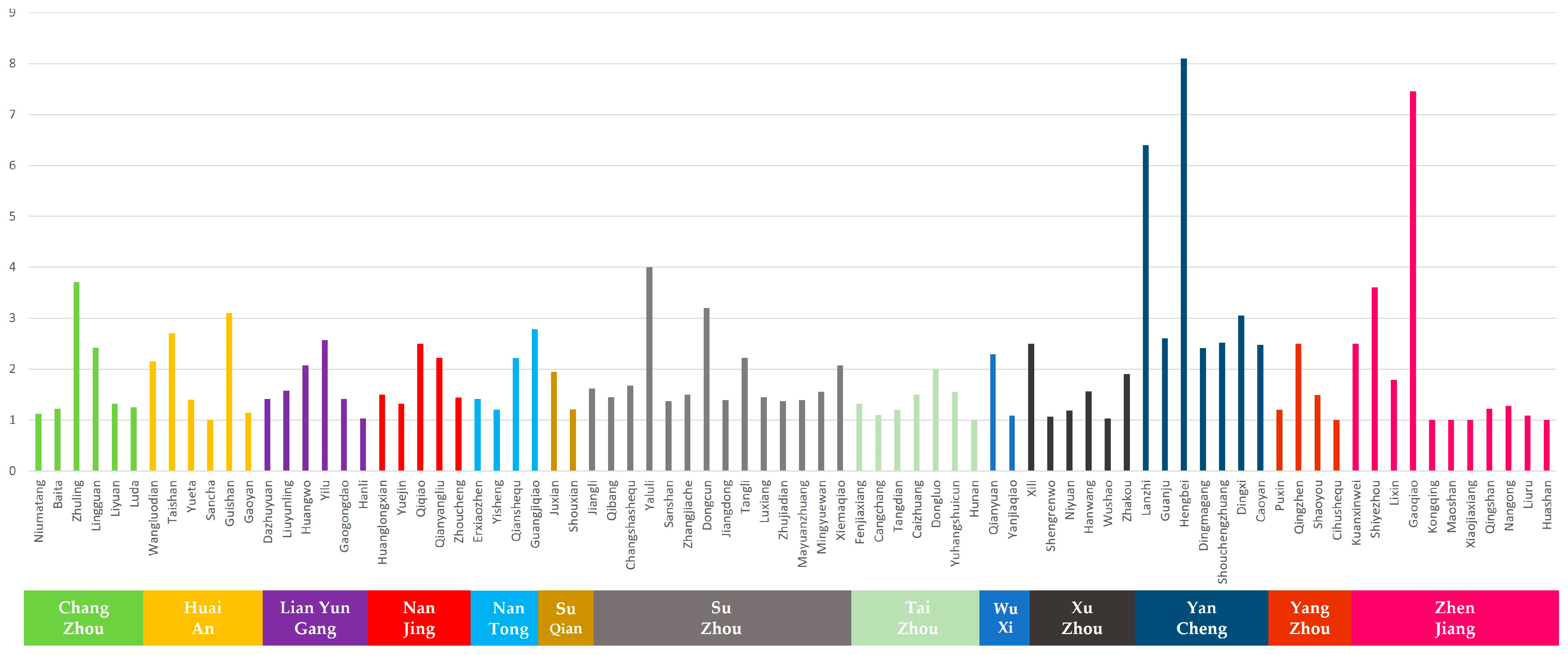
| Order | City | Traditional Village Name | Shape Index | |
|---|---|---|---|---|
| Aspect Ratio Value (λ) | Building Density Value (M) | |||
| 1 | Lianyungang | Dazhuyuan | 1.41 | 0.04 |
| 2 | Lianyungang | Liuyunling | 1.57 | 0.05 |
| 3 | Zhenjiang | Kuanxinwei | 2.50 | 0.05 |
| 4 | Yancheng | Lanzhi | 6.40 | 0.07 |
| 5 | Changzhou | Niumatang | 1.12 | 0.08 |
| 6 | Yancheng | Guanju | 2.60 | 0.1 |
| 7 | Yancheng | Hengbei | 8.10 | 0.11 |
| 8 | Nantong | Erxiaozhen | 1.41 | 0.12 |
| 9 | Huai’an | Wangluodian | 2.15 | 0.12 |
| 10 | Lianyungang | Huangwo | 2.07 | 0.13 |
| 11 | Lianyungang | Yilu | 2.57 | 0.13 |
| 12 | Suzhou | Jiangli | 1.62 | 0.14 |
| 13 | Zhenjiang | Shiyezhou | 3.60 | 0.14 |
| 14 | Suqian | Juxian | 1.94 | 0.15 |
| 15 | Nantong | Yisheng | 1.20 | 0.17 |
| 16 | Changzhou | Baita | 1.22 | 0.17 |
| 17 | Taizhou | Fenjiaxiang | 1.32 | 0.18 |
| 18 | Taizhou | Cangchang | 1.10 | 0.19 |
| 19 | Taizhou | Tangdian | 1.20 | 0.19 |
| 20 | Lianyungang | Gaogongdao | 1.41 | 0.19 |
| 21 | Changzhou | Zhuling | 3.71 | 0.19 |
| 22 | Huai’an | Taishan | 2.70 | 0.2 |
| 23 | Yangzhou | Puxin | 1.20 | 0.21 |
| 24 | Suzhou | Qibang | 1.45 | 0.21 |
| 25 | Taizhou | Caizhuang | 1.50 | 0.21 |
| 26 | Taizhou | Dongluo | 2.00 | 0.21 |
| 27 | Changzhou | Lingguan | 2.42 | 0.21 |
| 28 | Lianyungang | Hanli | 1.03 | 0.22 |
| 29 | Huai’an | Yueta | 1.40 | 0.22 |
| 30 | Suzhou | Changshashequ | 1.67 | 0.22 |
| 31 | Xuzhou | Xili | 2.50 | 0.22 |
| 32 | Yangzhou | Qingzhen | 2.50 | 0.22 |
| 33 | Huai’an | Sancha | 1.00 | 0.23 |
| 34 | Changzhou | Liyuan | 1.32 | 0.23 |
| 35 | Suzhou | Yaluli | 4.00 | 0.23 |
| 36 | Suzhou | Sanshan | 1.37 | 0.24 |
| 37 | Yangzhou | Shaoyou | 1.49 | 0.24 |
| 38 | Suzhou | Zhangjiache | 1.50 | 0.24 |
| 39 | Zhenjiang | Lixin | 1.79 | 0.24 |
| 40 | Nantong | Qianshequ | 2.21 | 0.24 |
| 41 | Huai’an | Guishan | 3.10 | 0.24 |
| 42 | Suzhou | Dongcun | 3.20 | 0.24 |
| 43 | Suzhou | Jiangdong | 1.39 | 0.25 |
| 44 | Xuzhou | Shengrenwo | 1.07 | 0.26 |
| 45 | Huai’an | Gaoyan | 1.14 | 0.26 |
| 46 | Changzhou | Luda | 1.25 | 0.26 |
| 47 | Suzhou | Tangli | 2.22 | 0.26 |
| 48 | Wuxi | Qianyuan | 2.29 | 0.26 |
| 49 | Zhenjiang | Gaoqiao | 7.45 | 0.26 |
| 50 | Xuzhou | Niyuan | 1.18 | 0.27 |
| 51 | Nanjing | Huanglongxian | 1.50 | 0.27 |
| 52 | Xuzhou | Hanwang | 1.56 | 0.27 |
| 53 | Yancheng | Dingmagang | 2.41 | 0.27 |
| 54 | Zhenjiang | Kongqing | 1.00 | 0.28 |
| 55 | Xuzhou | Wushao | 1.03 | 0.28 |
| 56 | Suzhou | Luxiang | 1.45 | 0.28 |
| 57 | Taizhou | Yuhangshuicun | 1.55 | 0.28 |
| 58 | Xuzhou | Zhakou | 1.90 | 0.28 |
| 59 | Taizhou | Hunan | 1.00 | 0.29 |
| 60 | Suqian | Shouxian | 1.21 | 0.29 |
| 61 | Suzhou | Zhujiadian | 1.37 | 0.29 |
| 62 | Zhenjiang | Maoshan | 1.00 | 0.3 |
| 63 | Wuxi | Yanjiaqiao | 1.09 | 0.3 |
| 64 | Zhenjiang | Xiaojiaxiang | 1.00 | 0.31 |
| 65 | Zhenjiang | Qingshan | 1.22 | 0.31 |
| 66 | Zhenjiang | Nangong | 1.28 | 0.31 |
| 67 | Suzhou | Mayuanzhuang | 1.39 | 0.31 |
| 68 | Yancheng | Shouchengzhuang | 2.52 | 0.31 |
| 69 | Suzhou | Mingyuewan | 1.55 | 0.32 |
| 70 | Yancheng | Dingxi | 3.05 | 0.32 |
| 71 | Yangzhou | Cihushequ | 1.00 | 0.33 |
| 72 | Zhenjiang | Liuru | 1.09 | 0.33 |
| 73 | Nanjing | Yuejin | 1.32 | 0.33 |
| 74 | Suzhou | Xiemaqiao | 2.07 | 0.34 |
| 75 | Yancheng | Caoyan | 2.47 | 0.34 |
| 76 | Zhenjiang | Huashan | 1.00 | 0.36 |
| 77 | Nantong | Guangjiqiao | 2.78 | 0.36 |
| 78 | Nanjing | Qiqiao | 2.50 | 0.39 |
| 79 | Nanjing | Qianyangliu | 2.22 | 0.41 |
| 80 | Nanjing | Zhoucheng | 1.44 | 0.42 |
References
- Song, Z.H.; Tang, P.; Wang, X.; Song, Y. Construction and Application of Analytic Model for Multi-Scale Hierarchical Structure in Historic Residential Areas. Archit. J. 2023, 10, 55–61. [Google Scholar] [CrossRef]
- Ma, W.; Jiang, G.; Wang, D.; Li, W.; Guo, H.; Zheng, Q. Rural settlements transition (RST) in a suburban area of metropolis: Internal structure perspectives. Sci. Total Environ. 2017, 615, 672–680. [Google Scholar] [CrossRef] [PubMed]
- Qin, R.J.; Leung, H.H. Becoming a Traditional Village: Heritage Protection and Livelihood Transformation of a Chinese Village. Sustainability 2021, 13, 2331. [Google Scholar] [CrossRef]
- Mohammed, M.; Shafiq, N.; Elmansoury, A.; Al-Mekhlafi, A.B.A.; Rached, E.F.; Zawawi, N.A.; Haruna, A.; Rafindadi, A.D.; Ibrahim, M.B. Modeling of 3R (Reduce, Reuse and Recycle) for Sustainable Construction Waste Reduction: A Partial Least Squares Structural Equation Modeling (PLS-SEM). Sustainability 2021, 13, 10660. [Google Scholar] [CrossRef]
- Egger, A.N.; Chowdhury, A.R.; Espinal, M.C.; Maddy, A.J. Birthmarks: Tradition, Culture, Myths, and Folklore. Dermatology 2020, 236, 216–218. [Google Scholar] [CrossRef] [PubMed]
- Nie, Z.; Li, N.; Pan, W.; Yang, Y.; Chen, W.; Hong, C. Quantitative Research on the Form of Traditional Villages Based on the Space Gene—A Case Study of Shibadong Village in Western Hunan, China. Sustainability 2022, 14, 8965. [Google Scholar] [CrossRef]
- Lei, Y.; Zhou, H. Analysis on Spatial Characteristics and the Adaptation Mechanism of Miao Traditional Settlement in Qiandong nan, China. Math. Probl. Eng. 2022, 2022, 6293833. [Google Scholar] [CrossRef]
- Liu, Q.; Liao, Z.; Wu, Y.; Mulugeta, D.D.; Zhang, Y. Cultural Sustainability and Vitality of Chinese Vernacular Architecture: A Pedigree for the Spatial Art of Traditional Villages in Jiangnan Region. Sustainability 2019, 11, 6898. [Google Scholar] [CrossRef]
- Liu, X.; Li, Y.; Wu, Y.; Li, C. The Spatial Pedigree in Traditional Villages under the Perspective of Urban Regeneration—Taking 728 Villages in Jiangnan Region, China as Cases. Land 2022, 11, 1561. [Google Scholar] [CrossRef]
- Guelke, L. An Idealist Alternative in Human Geography. Ann. Assoc. Am. Geogr. 1974, 64, 193–202. [Google Scholar] [CrossRef]
- Demangeon, A. La Geographie de I’habitat Rurale, Report of the Comission on Types of Rural Settlement; Montgomeryshire Express, Limited: Newton, UK, 1928. [Google Scholar]
- Heley, J.; Jones, L. Relational rurals: Some thoughts on relating things and theory in rural studies. J. Rural Stud. 2012, 28, 208–217. [Google Scholar] [CrossRef]
- Chen, Z.; Yang, H.; Lin, Y.; Xie, J.; Xie, Y.; Ding, Z. Exploring the association between the built environment and positive sentiments of tourists in traditional villages in Fuzhou, China. Ecol. Inform. 2024, 80, 102465. [Google Scholar] [CrossRef]
- Zhang, D.; Shi, Z.; Cheng, M. A Study on the Spatial Pattern of Traditional Villages from the Perspective of Courtyard House Distribution. Buildings 2023, 13, 1913. [Google Scholar] [CrossRef]
- Wu, W.; Zhang, W.; Zhuang, Z. Research on the Operation Mode of Village-type Nongjiale Cluster under Benefit Driving--Taking the Ancient Village of Mingyue Bay in Suzhou as an Example. Issues Agric. Econ. 2015, 36, 44–51+111. [Google Scholar] [CrossRef]
- Li, R.; Shi, Z. Spatial relationship and formation mechanism of traditional villages and intangible cultural heritage in the Yellow River Basin. Econ. Geogr. 2022, 42, 205–212. [Google Scholar] [CrossRef]
- Zhang, M. Research on the Protection and Renewal of Traditional Village Space in the Qiantang River Basin under the Rural Revitalization Strategy. Master’s Thesis, Zhejiang University of Technology, Hangzhou, China, 2019. [Google Scholar] [CrossRef]
- Wang, H. A Study on Spatial Form of Villages of Qinhe River Valley under Ze-Lu Merchants Group Affected. Master’s Thesis, Huazhong University of Science and Technology, Wuhan, China, 2014. [Google Scholar] [CrossRef]
- Wu, C.; Chen, M.; Zhou, L.; Liang, X.; Wang, W. Identifying the Spatiotemporal Patterns of Traditional Villages in China: A Multiscale Perspective. Land 2020, 9, 449. [Google Scholar] [CrossRef]
- Liu, W.; Xue, Y.; Shang, C. Spatial Distribution Analysis and Driving Factors of Traditional Villages in Henan Province: A Comprehensive Approach via Geospatial Techniques and Statistical Models. Herit. Sci. 2023, 11, 185. [Google Scholar] [CrossRef]
- Zhu, Q.; Liu, S. Spatial Morphological Characteristics and Evolution of Traditional Villages in the Mountainous Area of Southwest Zhejiang. ISPRS Int. J. Geo-Inf. 2023, 12, 317. [Google Scholar] [CrossRef]
- Liu, X.; Zhang, Y.; Li, Y.; Zhang, A.; Li, C. Exploring Village Spatial Patterns for Sustainable Development:A Case Study of Diqing Prefecture. Sustainability 2023, 15, 16362. [Google Scholar] [CrossRef]
- Wang, Y.; Fan, J. Technological Mediation of Photovoltaic System to Improve Rural Sustainability in the Background of Resettlement and Consolidation:Evidence from the Rural Community and Villages in China. Sustainability 2023, 15, 9579. [Google Scholar] [CrossRef]
- Yin, H.; Xiao, R.; Fei, X.; Zhang, Z.; Gao, Z.; Wan, Y.; Tan, W.; Jiang, W.; Cao, W.; Guo, Y. Analyzing “economy-society-environment” sustainability from the perspective of urban spatial structure: A case study of the Yangtze River delta urban agglomeration. Sustain. Cities Soc. 2023, 96, 104691. [Google Scholar] [CrossRef]
- Opon, J.; Henry, M. An Indicator Framework for Quantifying the Sustainability of Concrete Materials from the Perspectives of Global Sustainable Development. J. Clean. Prod. 2019, 218, 718–737. [Google Scholar] [CrossRef]
- Lin, Z.; Liang, Y.; Liu, X. Study on spatial form evolution of traditional villages in Jiuguan under the influence of historic transportation network. Herit Sci. 2024, 12, 29. [Google Scholar] [CrossRef]
- Huang, Y.; Zhang, Z.; Fei, J.; Chen, X. Optimization Strategies of Commercial Layout of Traditional Villages Based on Space Syntax and Space Resistance Model: A Case Study of Anhui Longchuan Village in China. Buildings 2023, 13, 1016. [Google Scholar] [CrossRef]
- Xu, L.; Liu, K.; Sang, K.; Lin, G.; Luo, Q.; Huang, C.; Giordano, A. Assessment of the Exterior Quality of Traditional Residences: A Genetic Algorithm–Backpropagation Approach. Buildings 2022, 12, 559. [Google Scholar] [CrossRef]
- Guo, Z.; Shao, X.; Xu, Y.; Miyazaki, H.; Ohira, W.; Shibasaki, R. Identification of Village Building via Google Earth Images and Supervised Machine Learning Methods. Remote Sens. 2016, 8, 271. [Google Scholar] [CrossRef]
- Savaşkan, M.O.; Özener, O.Ö. H-BIM applications for vernacular architecture: A historic rural house case study in Bursa, Turkey. Eng. Constr. Archit. Manag. 2023, 30, 3997–4017. [Google Scholar] [CrossRef]
- Alshawabkeh, Y.; Baik, A.; Fallatah, A. As-Textured As-Built BIM Using Sensor Fusion, Zee Ain Historical Village as a Case Study. Remote Sens. 2021, 13, 5135. [Google Scholar] [CrossRef]
- Liu, W.; Liu, Z. Simulation Analysis of Supply Chain Resilience of Prefabricated Building Projects Based on System Dynamics. Buildings 2023, 13, 2629. [Google Scholar] [CrossRef]
- Arasteh, M.A.; Farjami, Y. New hydro-economic system dynamics and agent-based modeling for sustainable urban groundwater management: A case study of Dehno, Yazd Province, Iran. Sustain. Cities Soc. 2021, 72, 103078. [Google Scholar] [CrossRef]
- Gao, X.; Liu, Y.; Liu, L.; Li, Q.; Deng, O.; Wei, Y.; Ling, J.; Zeng, M. Is Big Good or Bad?: Testing the Performance of Urban Growth Cellular Automata Simulation at Different Spatial Extents. Sustainability 2018, 10, 4758. [Google Scholar] [CrossRef]
- Michel, O.O.; Ying, Y.; Wenyi, F.; Chen, C.; Kaiko, K.S. Examining Land Use/Land Cover Change and Its Prediction Based on a Multilayer Perceptron Markov Approach in the Luki Biosphere Reserve, Democratic Republic of Congo. Sustainability 2021, 13, 6898. [Google Scholar] [CrossRef]
- An, Y.; Wu, X.; Liu, R.; Liu, L.; Liu, P. Quantitative Analysis Village Spatial Morphology Using “SPSS + GIS” Approach: A Case Study of Linxia Hui Autonomous Prefecture. Sustainability 2023, 15, 16828. [Google Scholar] [CrossRef]
- Li, W.; Zhang, P.; Zhao, K.; Chen, H.; Zhao, S. The Evolution Model of and Factors Influencing Digital Villages: Evidence from Guangxi, China. Agriculture 2023, 13, 659. [Google Scholar] [CrossRef]
- Wang, P.; Li, C.; Huang, C. The Impact of Digital Village Construction on County-Level Economic Growth and Its Driving Mechanisms: Evidence from China. Agriculture 2023, 13, 1917. [Google Scholar] [CrossRef]
- Li, X.; Liu, X. Embedding sustainable development strategies in agent-based models for use as a planning tool. Int. J. Geogr. Inf. Sci. 2008, 22, 21–45. [Google Scholar] [CrossRef]
- Pu, X.; Wang, Z.H.; Gao, L.; Huang, Q. Study on the Ordinal Value of Directionality of the House Plane Figure in Rural Settlement. Archit. J. 2013, 5, 111–115. [Google Scholar] [CrossRef]
- Li, M.; Yan, Y.; Ying, Z.; Zhou, L. Measuring Villagers’ Perceptions of Changes in the Landscape Values of Traditional Villages. ISPRS Int. J. Geo-Inf. 2024, 13, 60. [Google Scholar] [CrossRef]
- Liu, Z.; Qin, W. Research on the Spatial Complexity of Traditional Village in Beijing Based on Fractal Theory. Small Town Constr. 2018, 52–58. [Google Scholar] [CrossRef]
- Zhu, G. A brief discussion on the importance of protection and development of traditional villages in Jiangsu Province—For a bright future of Jiangsu rural areas. Rural. Plan. Constr. 2017, 35–39. Available online: https://kns.cnki.net/kcms2/article/abstract?v=dKAmn0h-MOuBSanyTpa908UjMF5tdvMeV67DCQmwI0mXNPcLMcbwqfvUsdFO65sBkBxWIVn7iBjDv2zJsm76dR3c2fi8eizNBpdjFFa-u1hr9rzf7XuRza0yxyDbZNHI0nL_beTo2Gg=&uniplatform=NZKPT&language=CHS (accessed on 21 March 2021).
- Han, R.; Feng, C.; Xu, N.; Guo, L. Spatial Heterogeneous Relationship between Ecosystem Services and Human Disturbances: A Case Study in Chuandong, China. Sci. Total Environ. 2020, 721, 137818. [Google Scholar] [CrossRef] [PubMed]
- Shaker, R.; Altman, Y.; Deng, C.; Vaz, E.; Forsythe, K. Investigating Urban Heat Island through Spatial Analysis of New York City Streetscapes. J. Clean. Prod. 2019, 233, 972–992. [Google Scholar] [CrossRef]
- Wang, J.; Li, X.; Christakos, G.; Liao, Y.; Zhang, T.; Gu, X.; Zheng, X. Geographical detectors-based health risk assessment and its application in the neural tube defects study of the Heshun region, China. Int. J. Geogr. Inf. Sci. 2010, 24, 107–127. [Google Scholar] [CrossRef]
- Wang, J.F.; Hu, Y. Environmental health risk detection with GeogDetector. Environ. Model. Softw. 2012, 33, 114–115. [Google Scholar] [CrossRef]
- Liu, J.; Xu, Q.; Yi, J.; Huang, X. Analysis of the heterogeneity of urban expansion landscape patterns and driving factors based on a combined Multi-Order Adjacency Index and Geodetector model. Ecol. Indic. 2022, 136, 108655. [Google Scholar] [CrossRef]
- Zhao, S.; Zhang, C.; Qi, J. The Key Factors Driving the Development of New Towns by Mother Cities and Regions: Evidence from China. ISPRS Int. J. Geo-Inf. 2021, 10, 223. [Google Scholar] [CrossRef]
- Wang, H.; Qin, F.; Xu, C.; Li, B.; Guo, L.; Wang, Z. Evaluating the suitability of urban development land with a Geodetector. Ecol. Indic. 2021, 123, 107339. [Google Scholar] [CrossRef]
- Ma, Y.; Zhang, P.; Zhao, K.; Zhou, Y.; Zhao, S. A Dynamic Performance and Differentiation Management Policy for Urban Construction Land Use Change in Gansu, China. Land 2022, 11, 942. [Google Scholar] [CrossRef]
- Shao, C.; Zhan, X.; Chen, S. Evaluation index system of rural sustainable development based on SDGs. China Popul. Resour. Environ. 2023, 33, 21–31. [Google Scholar] [CrossRef]
- Mo, L. Analysis of Sustainable Development of Rural Tourism Resources System in Hainan. Chin. J. Agric. Resour. Reg. Plan. 2017, 38, 170–177. [Google Scholar] [CrossRef]
- Wang, R.; Dai, M.; Ou-Yang, H.; Ma, X. Measurement of Rural Households’ Livelihood Assets with Cultural Capital Intervention: A Case Study of Likeng Village in Wuyuan. Tour. Trib. 2021, 36, 56–66. [Google Scholar] [CrossRef]
- Chen, J.; Ma, H.; Yang, S.; Zhou, Z.; Huang, J.; Chen, L. Assessment of Urban Resilience and Detection of Impact Factors Based on Spatial Autocorrelation Analysis and GeoDetector Model: A Case of Hunan Province. ISPRS Int. J. Geo-Inf. 2023, 12, 391. [Google Scholar] [CrossRef]
- Li, Y.; Xia, M.; Ma, Q.; Zhou, R.; Liu, D.; Huang, L. Identifying the Influencing Factors of Cooling Effect of Urban Blue Infrastructure Using the Geodetector Model. Remote Sens. 2022, 14, 5495. [Google Scholar] [CrossRef]
- Li, B. The Research on Conservation and Development Planning of Traditional Villages from the Perspective of HeritageTourism in South of Anhui—Taking Lingxia Village in Anhui Province as an Example. Master’s Thesis, Hefei University of Technology, Hefei, China, 2016. [Google Scholar] [CrossRef]
- Zhang, Q.; Wang, J. Spatial Differentiation and Driving Factors of Traditional Villages in Jiangsu Province. Sustainability 2023, 15, 11448. [Google Scholar] [CrossRef]


| Variable | Code | SDG Type | Indicator | Type |
|---|---|---|---|---|
| Dependent | Y1 | - | Spatial Distribution of Traditional Villages (SD) | Morphology System |
| Y2 | - | Spatial Pattern Distribution of Building Density Indicators () | ||
| Y3 | - | Spatial Pattern Distribution of Aspect Ratio Indicators (M) | ||
| Independent | X1 | SDG15— Life on Land | Elevation (DEM) | Environmental System |
| X2 | SDG13— Climate Action | Forest Coverage Rate | ||
| X3 | SDG6— Clean Water and Sanitation | Distribution of Water Systems | ||
| X4 | SDG14— Life bellow Water | Fishery Revenue | ||
| X5 | SDG7— Affordable and Clean Energy | Penetration Rate of Natural Gas (%) | ||
| X6 | SDG12—Responsible Consumption and Production | Wastewater Treatment Rate (%) | ||
| X7 | SDG8— Decent Work and Economic Growth | Gross Domestic Product (GDP) | Economic System | |
| X8 | SDG9— Industry, Innovation, and Infrastructure | GDP of Secondary Industry Added Value | ||
| X9 | SDG2—Zero Hunger | Facility Agriculture Area | ||
| X10 | SDG17— Partnerships for The Goals | Number of Fixed Telephone Users/Resident Population (%) | ||
| X11 | SDG1—No Poverty | Government Revenue | ||
| X12 | SDG11—Sustainable Cities and Communities | Number of Permanent Residents | Social System | |
| X13 | SDG10—Reduced Inequalities | Disposable Income Difference: Urban/Rural (%) | ||
| X14 | SDG4— Quality Education | Number of Middle School Students in School | ||
| X15 | SDG5— Gender Equality | Number of Searches Per Capita for “Gender Equality” | ||
| X16 | SDG3— Good Health and Well-being | Number of Hospital Beds Per 10,000 People | ||
| X17 | SDG16— Peace, Justice, and Strong Institutions | Number of Beds in Various Social Welfare Adoption Units Per 10,000 People |
| SDG Type | Code | Y1 | Y2 | Y3 | |||
|---|---|---|---|---|---|---|---|
| q | p | q | p | q | p | ||
| SDG15—Life on Land | X1(SDG15) | 0.02 | 0.00 | 0.09 | 0.00 | 0.12 | 0.00 |
| SDG13—Climate Action | X2(SDG13) | 0.27 | 0.00 | 0.21 | 0.00 | 0.29 | 0.00 |
| SDG6—Clean Water and Sanitation | X3(SDG6) | 0.01 | 0.004 | 0.01 | 0.21 | 0.03 | 0.00 |
| SDG14—Life Below Water | X4(SDG14) | 0.35 | 0.00 | 0.26 | 0.00 | 0.28 | 0.00 |
| SDG7—Affordable and Clean Energy | X5(SDG7) | 0.27 | 0.00 | 0.21 | 0.00 | 0.29 | 0.00 |
| SDG12—Responsible Consumption and Production | X6(SDG12) | 0.02 | 0.00 | 0.01 | 0.13 | 0.01 | 0.00 |
| SDG8—Decent Work and Economic Growth | X7(SDG8) | 0.18 | 0.00 | 0.18 | 0.00 | 0.09 | 0.00 |
| SDG9—Industry, Innovation, and Infrastructure | X8(SDG9) | 0.23 | 0.00 | 0.08 | 0.00 | 0.06 | 0.00 |
| SDG2—Zero Hunger | X9(SDG2) | 0.12 | 0.00 | 0.19 | 0.00 | 0.30 | 0.00 |
| SDG17—Partnerships for The Goals | X10(SDG17) | 0.26 | 0.00 | 0.03 | 0.00 | 0.16 | 0.00 |
| SDG1—No Poverty | X11(SDG1) | 0.27 | 0.00 | 0.21 | 0.00 | 0.29 | 0.00 |
| SDG11—Sustainable Cities and Communities | X12(SDG11) | 0.06 | 0.00 | 0.12 | 0.00 | 0.07 | 0.00 |
| SDG10—Reduced Inequalities | X13(SDG10) | 0.20 | 0.00 | 0.09 | 0.00 | 0.04 | 0.00 |
| SDG4—Quality Education | X14(SDG4) | 0.09 | 0.00 | 0.09 | 0.00 | 0.11 | 0.00 |
| SDG5—Gender Equality | X15(SDG5) | 0.05 | 0.00 | 0.12 | 0.00 | 0.10 | 0.00 |
| SDG3—Good Health and Well-being | X16(SDG3) | 0.09 | 0.00 | 0.08 | 0.00 | 0.08 | 0.00 |
| SDG16—Peace, Justice, and Strong Institutions | X17(SDG16) | 0.13 | 0.00 | 0.28 | 0.00 | 0.18 | 0.00 |
| SDG | 15 | 13 | 6 | 14 | 7 | 12 | 8 | 9 | 2 | 17 | 1 | 11 | 10 | 4 | 5 | 3 | 16 |
|---|---|---|---|---|---|---|---|---|---|---|---|---|---|---|---|---|---|
| 15 | 0.02 | ||||||||||||||||
| 13 | 0.35 | 0.27 | |||||||||||||||
| 6 | 0.05 | 0.32 | 0.01 | ||||||||||||||
| 14 | 0.40 | 0.41 | 0.40 | 0.35 | |||||||||||||
| 7 | 0.35 | 0.27 | 0.32 | 0.41 | 0.27 | ||||||||||||
| 12 | 0.05 | 0.31 | 0.04 | 0.38 | 0.31 | 0.02 | |||||||||||
| 8 | 0.28 | 0.46 | 0.23 | 0.46 | 0.46 | 0.21 | 0.18 | ||||||||||
| 9 | 0.28 | 0.49 | 0.28 | 0.49 | 0.49 | 0.25 | 0.42 | 0.23 | |||||||||
| 2 | 0.19 | 0.42 | 0.18 | 0.46 | 0.42 | 0.15 | 0.34 | 0.43 | 0.12 | ||||||||
| 17 | 0.31 | 0.50 | 0.31 | 0.51 | 0.50 | 0.29 | 0.42 | 0.39 | 0.41 | 0.26 | |||||||
| 1 | 0.35 | 0.27 | 0.32 | 0.41 | 0.27 | 0.31 | 0.46 | 0.49 | 0.42 | 0.50 | 0.27 | ||||||
| 11 | 0.12 | 0.43 | 0.12 | 0.46 | 0.43 | 0.10 | 0.32 | 0.42 | 0.28 | 0.47 | 0.43 | 0.06 | |||||
| 10 | 0.24 | 0.48 | 0.24 | 0.48 | 0.48 | 0.23 | 0.39 | 0.31 | 0.37 | 0.41 | 0.48 | 0.39 | 0.20 | ||||
| 4 | 0.16 | 0.51 | 0.15 | 0.47 | 0.51 | 0.14 | 0.36 | 0.44 | 0.32 | 0.44 | 0.51 | 0.25 | 0.40 | 0.09 | |||
| 5 | 0.12 | 0.45 | 0.11 | 0.46 | 0.45 | 0.09 | 0.35 | 0.39 | 0.30 | 0.41 | 0.45 | 0.21 | 0.42 | 0.29 | 0.05 | ||
| 3 | 0.14 | 0.49 | 0.15 | 0.46 | 0.49 | 0.12 | 0.37 | 0.39 | 0.32 | 0.42 | 0.49 | 0.32 | 0.36 | 0.34 | 0.38 | 0.09 | |
| 16 | 0.19 | 0.47 | 0.20 | 0.46 | 0.47 | 0.17 | 0.35 | 0.49 | 0.29 | 0.45 | 0.47 | 0.34 | 0.45 | 0.38 | 0.36 | 0.33 | 0.13 |
| SDG | 15 | 13 | 6 | 14 | 7 | 12 | 8 | 9 | 2 | 17 | 1 | 11 | 10 | 4 | 5 | 3 | 16 |
|---|---|---|---|---|---|---|---|---|---|---|---|---|---|---|---|---|---|
| 15 | 0.12 | ||||||||||||||||
| 13 | 0.43 | 0.29 | |||||||||||||||
| 6 | 0.18 | 0.36 | 0.03 | ||||||||||||||
| 14 | 0.34 | 0.40 | 0.36 | 0.28 | |||||||||||||
| 7 | 0.43 | 0.29 | 0.36 | 0.40 | 0.29 | ||||||||||||
| 12 | 0.14 | 0.32 | 0.06 | 0.32 | 0.32 | 0.01 | |||||||||||
| 8 | 0.41 | 0.77 | 0.19 | 0.76 | 0.77 | 0.14 | 0.09 | ||||||||||
| 9 | 0.28 | 0.63 | 0.13 | 0.58 | 0.63 | 0.10 | 0.46 | 0.06 | |||||||||
| 2 | 0.48 | 0.73 | 0.36 | 0.76 | 0.73 | 0.34 | 0.57 | 0.64 | 0.30 | ||||||||
| 17 | 0.36 | 0.60 | 0.26 | 0.66 | 0.60 | 0.20 | 0.63 | 0.35 | 0.65 | 0.16 | |||||||
| 1 | 0.43 | 0.29 | 0.36 | 0.40 | 0.29 | 0.32 | 0.77 | 0.63 | 0.73 | 0.60 | 0.29 | ||||||
| 11 | 0.32 | 0.61 | 0.17 | 0.76 | 0.61 | 0.11 | 0.52 | 0.48 | 0.62 | 0.57 | 0.62 | 0.07 | |||||
| 10 | 0.30 | 0.71 | 0.11 | 0.66 | 0.71 | 0.08 | 0.50 | 0.33 | 0.58 | 0.45 | 0.71 | 0.45 | 0.04 | ||||
| 4 | 0.34 | 0.74 | 0.23 | 0.75 | 0.74 | 0.15 | 0.56 | 0.43 | 0.65 | 0.62 | 0.75 | 0.41 | 0.45 | 0.11 | |||
| 5 | 0.39 | 0.71 | 0.19 | 0.68 | 0.71 | 0.13 | 0.48 | 0.59 | 0.64 | 0.64 | 0.70 | 0.33 | 0.47 | 0.57 | 0.10 | ||
| 3 | 0.32 | 0.72 | 0.16 | 0.59 | 0.72 | 0.12 | 0.54 | 0.58 | 0.60 | 0.64 | 0.71 | 0.47 | 0.43 | 0.65 | 0.40 | 0.08 | |
| 16 | 0.30 | 0.63 | 0.17 | 0.61 | 0.63 | 0.13 | 0.48 | 0.54 | 0.56 | 0.64 | 0.63 | 0.52 | 0.54 | 0.58 | 0.53 | 0.57 | 0.08 |
| SDG | 15 | 13 | 6 | 14 | 7 | 12 | 8 | 9 | 2 | 17 | 1 | 11 | 10 | 4 | 5 | 3 | 16 |
|---|---|---|---|---|---|---|---|---|---|---|---|---|---|---|---|---|---|
| 15 | 0.09 | ||||||||||||||||
| 13 | 0.27 | 0.21 | |||||||||||||||
| 6 | 0.13 | 0.28 | 0.01 | ||||||||||||||
| 14 | 0.34 | 0.41 | 0.37 | 0.26 | |||||||||||||
| 7 | 0.27 | 0.21 | 0.28 | 0.41 | 0.21 | ||||||||||||
| 12 | 0.12 | 0.26 | 0.04 | 0.30 | 0.26 | 0.01 | |||||||||||
| 8 | 0.36 | 0.62 | 0.26 | 0.64 | 0.62 | 0.22 | 0.18 | ||||||||||
| 9 | 0.25 | 0.59 | 0.19 | 0.63 | 0.59 | 0.13 | 0.48 | 0.08 | |||||||||
| 2 | 0.35 | 0.72 | 0.25 | 0.67 | 0.72 | 0.22 | 0.43 | 0.53 | 0.19 | ||||||||
| 17 | 0.22 | 0.60 | 0.11 | 0.54 | 0.60 | 0.09 | 0.54 | 0.37 | 0.43 | 0.03 | |||||||
| 1 | 0.27 | 0.22 | 0.28 | 0.41 | 0.22 | 0.26 | 0.62 | 0.59 | 0.71 | 0.59 | 0.21 | ||||||
| 11 | 0.27 | 0.69 | 0.19 | 0.58 | 0.69 | 0.16 | 0.48 | 0.54 | 0.35 | 0.46 | 0.69 | 0.12 | |||||
| 10 | 0.36 | 0.73 | 0.18 | 0.72 | 0.73 | 0.14 | 0.57 | 0.35 | 0.62 | 0.52 | 0.73 | 0.61 | 0.09 | ||||
| 4 | 0.29 | 0.71 | 0.16 | 0.61 | 0.71 | 0.13 | 0.54 | 0.51 | 0.45 | 0.55 | 0.71 | 0.33 | 0.63 | 0.09 | |||
| 5 | 0.28 | 0.70 | 0.17 | 0.66 | 0.70 | 0.17 | 0.48 | 0.58 | 0.47 | 0.47 | 0.70 | 0.42 | 0.51 | 0.64 | 0.12 | ||
| 3 | 0.26 | 0.80 | 0.14 | 0.66 | 0.80 | 0.12 | 0.44 | 0.53 | 0.48 | 0.50 | 0.79 | 0.37 | 0.45 | 0.69 | 0.35 | 0.08 | |
| 16 | 0.38 | 0.69 | 0.35 | 0.69 | 0.69 | 0.31 | 0.54 | 0.67 | 0.53 | 0.72 | 0.69 | 0.47 | 0.69 | 0.70 | 0.52 | 0.48 | 0.27 |
Disclaimer/Publisher’s Note: The statements, opinions and data contained in all publications are solely those of the individual author(s) and contributor(s) and not of MDPI and/or the editor(s). MDPI and/or the editor(s) disclaim responsibility for any injury to people or property resulting from any ideas, methods, instructions or products referred to in the content. |
© 2024 by the authors. Licensee MDPI, Basel, Switzerland. This article is an open access article distributed under the terms and conditions of the Creative Commons Attribution (CC BY) license (https://creativecommons.org/licenses/by/4.0/).
Share and Cite
Wang, H.; Shan, Y.; Xia, S.; Cao, J. Traditional Village Morphological Characteristics and Driving Mechanism from a Rural Sustainability Perspective: Evidence from Jiangsu Province. Buildings 2024, 14, 1302. https://doi.org/10.3390/buildings14051302
Wang H, Shan Y, Xia S, Cao J. Traditional Village Morphological Characteristics and Driving Mechanism from a Rural Sustainability Perspective: Evidence from Jiangsu Province. Buildings. 2024; 14(5):1302. https://doi.org/10.3390/buildings14051302
Chicago/Turabian StyleWang, Haobing, Yong Shan, Sisi Xia, and Jun Cao. 2024. "Traditional Village Morphological Characteristics and Driving Mechanism from a Rural Sustainability Perspective: Evidence from Jiangsu Province" Buildings 14, no. 5: 1302. https://doi.org/10.3390/buildings14051302