Article

Climate, Management and Habitat Associations of Avian Fauna in Restored Wetlands of California’s Central Valley, USA

1
Department of Wildlife, Humboldt State University, 1 Harpst St. Arcata, CA 95521, USA
2
United States Geological Survey, Cooperative Fish and Wildlife Research Unit, Humboldt State University, Arcata, CA 95521, USA
3
Conservation Science, 3820 Cypress Drive #11, Petaluma, CA 94954, USA
4
Department of Watershed Science and Department of Civil and Environmental Engineering, Colorado State University, Fort Collins, CO 80523, USA
*
Author to whom correspondence should be addressed.
Diversity 2012, 4(4), 396-418; https://doi.org/10.3390/d4040396
Submission received: 3 September 2012 / Revised: 30 October 2012 / Accepted: 15 November 2012 / Published: 23 November 2012

Abstract

:
The Wetlands Reserve Program (WRP) is one of several programs implemented by the United States Department of Agriculture to facilitate natural resource management on private lands. Since the WRP’s inception approximately 29,000 ha in California’s Central Valley (CCV) have been restored. However until now, actual benefits of the program to wildlife have never been evaluated. Hydrology in the CCV has been heavily modified and WRP wetlands are managed primarily to support wintering waterfowl. We surveyed over 60 WRP easements in 2008 and 2009 to quantify avian use and categorized bird species into 11 foraging guilds. We detected over 200 bird species in 2008 and 119 species in 2009, which is similar to or higher than numbers observed on other managed sites in the same area. We found that actively managed WRP wetlands support more waterfowl than sites under low or intermediate management, which is consistent with intended goals. Despite reported water shortages, greater upland and un-restored acreage in the southern CCV, WRP wetlands support large numbers of waterfowl and shorebirds, particularly in the early fall months. This is probably due to the severe lack of alternative habitat such as wildlife friendly crops at appropriate stages of the migration cycle. Improved access to water resources for hydrological management would greatly enhance waterfowl use in the southern CCV.

Graphical Abstract

1. Introduction

Global wetland losses over the last two centuries are largely the result of increasing human population and economic development. As a result, it is estimated that 20% of all wetland dependent bird species worldwide are either extinct or threatened with extinction [1]. The conterminous United States has lost more than half of its wetlands to agricultural development and urbanization [2]. Some of the heaviest losses were experienced in California, where losses began in the mid-1800s. California’s Central Valley (CCV), which makes up 10% of the state, converted over 95% of its depressional wetlands and 98% of its riparian wetlands into farmland or urban areas [3]. Prior to these conversions, the CCV was comprised of nearly 2 million ha of wetland habitat. The valley floor was dominated by grassland interspersed with wetland vegetation such as tules (Schoenoplectus acutus) and bottomland forests in the floodplains of streams and rivers [4]. At present, only about 100,000 ha of wetland habitat remain, two thirds of which are privately managed [3].
Despite heavy wetland losses, the CCV remains one of the most important migration, wintering and breeding areas for wetland dependent birds in North America, supporting over 60% of the total Pacific Flyway waterfowl population [3]. Each year, millions of birds, primarily ducks, geese and shorebirds flock to the CCV, putting immense pressure on reduced habitat resources [5]. To compensate for habitat losses, the U.S. Department of Agriculture (USDA) initiated a variety of conservation programs intended to assist farmers and ranchers in addressing natural resource concerns on private lands. Among these is the Wetlands Reserve Program (WRP) which was created as part of the 1990 Farm Bill [6] and is administered by the USDA’s Natural Resources Conservation Service (NRCS). The WRP is an easement program that compensates landowners for the conversion of flood prone crop or ranch land to wetland habitat. Since the WRP’s inception, it has resulted in the restoration of approximately 29,000 ha in the CCV. Although WRP is widely viewed as benefiting wildlife, there has been little or no evaluation of any benefits provided in the CCV.
Restored wetlands often fail to achieve their targeted functions including reestablishment of biodiversity and use by target species [7,8]. Assessment of ecosystem services and wildlife benefits are essential to developing more effective wetland conservation programs. Furthermore, federal accountability initiatives require that federal agencies demonstrate the effectiveness of their programs in meeting program objectives and goals. Recent studies indicate that on-site habitat characteristics and management of restored wetlands impact occupancy and suitability for birds [9,10]. On-site features such as emergent vegetation height, presence of woody vegetation and water depth influence wetland suitability for specific avian guilds [9,11,12].
Hydrology is a major factor driving wetland function [8] and the management of restored easements is largely driven by access to water. Growing urban and agricultural demands on water supplies in the CCV make water increasingly expensive and unreliable. Water from snowmelt and rainfall ameliorate water shortages to some extent in the winter and spring; however, the southern CCV inevitably experiences greater shortfalls than the remainder of the CCV due to its drier climate. Hence, water shortages result is a number of unmanaged and unrestored WRP easements, particularly in the southern CCV (Table 1). Avian use of restored but unmanaged wetlands with limited water access in relation to actively managed sites in water rich areas has not been investigated to our knowledge. Management intensity relates to the application of conservation practices essentially geared towards water application and withdrawal, vegetation control (disking, mowing) and attracting wintering waterfowl for sport (Table 2). Actively managed WRPs are generally more intensively managed, including hydrological manipulation, topographic manipulation, riparian buffer and native grass planting, burning and mowing. Intermediately managed sites receive about half as much hydrological manipulation in the years since restoration and almost no vegetation management. Unmanaged sites typically receive no artificial manipulations whatsoever. One of the most common practices on actively managed WRPs is moist soil management, a technique designed to encourage germination of waterfowl friendly seed-producing plants through hydrological manipulation and weed control. In addition to management, restored wetland age and local climate are expected to influence habitat structure and therefore avian occupancy.
Table 1. Distribution of Wetlands Reserve Program (WRP) in California’s Central Valley categorized by management intensity within each sub-basin. Management intensity information was derived from interviews with 77 land owners, managers, WRP easement contract records and Natural Resources Conservation Service (NRCS) staff [13]; management categories are described in the Experimental Section.
LocationManagement Intensity (%)
LowIntermediateActiveNot restoredNo data
SacramentoNorth9.848.040.20.02.0
San JoaquinCentral3.018.29.13.066.7
TulareSouth27.919.716.436.10.0
Table 2. Proportion of sites in California’s Central Valley in which specific management activities were applied by management intensity. Management categories are described in Experimental Section. Information was derived from interviews with 77 land owners, managers and NRCS biologists [13].
Management ActivityManagement Intensity
LowIntermediateHigh
Annual Flood 47.182.687.5
Active drawdown 16.759.162.5
Management for Waterfowl 64.385.293.5
Management for Shorebirds 18.853.839.4
Management for other birds a31.334.818.8
Grazed 35.752.032.1
Disked 18.863.063.3
Mowed42.973.178.3
Sprayed66.785.2100.0
Mosquito spray14.328.618.2
Burned 7.127.339.3
a Upland species such as pheasant and quail.
Our research objectives were (1) to identify and record avian species that use restored wetlands in California’s Central Valley; (2) to quantify avian use along three primary gradients; precipitation (north to south by sub-basins), age since restoration and; management intensity and (3) to assess relationships between bird use and on-site habitat characteristics.

2. Experimental

2.1. Study Area

California’s Central Valley is an elongated sedimentary basin about 650 km long, 120 km wide and covers an area of 108,800 km2 [14]. It is often subdivided into three sub-basins; the Sacramento in the north, the San Joaquin in the center and the Tulare in the south (Figure 1). Topography is relatively flat throughout the valley, with elevation ranging from 120 m in the north and south to below sea level near San Francisco Bay [14]. Boundaries of the valley are not precisely defined since valley grasslands grade into oak-grassland savannas of the foothills everywhere except the south, where desert conditions exist. Climate of the valley is Mediterranean, with warm, dry summers and mild, wet winters. Air temperatures vary little throughout the valley, with average July highs approaching 38 °C in both Bakersfield (Tulare sub-basin) and Redding (Sacramento sub-basin), while average December lows in Bakersfield (2.9 °C) are only slightly warmer than in Redding (2.7 °C). Annual precipitation, however, exhibits a distinct gradient, ranging from 16 cm in Bakersfield to 46 cm in Sacramento and 100 cm in Redding (Figure 1).
Figure 1. Location of 2008 and 2009 sampling sites (squares) in California’s Central Valley. For this study, the California’s Central Valley (CCV) was divided into three major sub-basins; Sacramento; San Joaquin and Tulare. Gradient in estimated average annual precipitation (1971–2000) is illustrated with color, with red being driest and blue wettest (PRISM Climate Group 2009).
Diversity 04 00396 g001
Throughout the valley, most annual precipitation falls as rain during November–May. The valley’s hydrological basins historically received overland flooding from the Sacramento and San Joaquin Rivers, which fed the seasonal wetlands and vernal pools of the region. Prior to the habitat conversions of the last two centuries, the largest freshwater wetland area in California was associated with Tulare, Buena Vista and Kern Lakes. These lakes contained as much as 3,360 km of freshwater marsh habitats along their shorelines, although the amount naturally varied. Dramatic alterations in water availability in the CCV have impacted management of restored wetlands. Today, the construction of flood control reservoirs, levees and dams have largely eliminated the natural lakes of the southern CCV as well as natural flooding regimes in the rest of the valley [3].
Most WRP easements in the CCV are designed to direct water from adjacent canals and channels to impoundments bounded by 1–2 meter high levees. Each WRP is typically divided into smaller sections or management units also sometimes referred to as “cells”. Cells are separated by 1–2 m high levees that correspond to natural elevation changes in the landscape. The number and size of cells vary among WRP easements, however, their functions are fundamentally the same i.e., to facilitate water delivery to individual cells to create a mosaic of varying seral stages.

2.2. Site Selection

A stratified random sampling approach was applied to select sampling units across three primary gradients; (1) restoration age, (2) management intensity and (3) precipitation which varies latitudinally by sub-basin. The climatic gradient was represented by three sub-basins; the Sacramento to the north, San Joaquin in the center and Tulare sub-basin to the south that correspond to the precipitation gradient (Figure 1). Sites were categorized into two broad age classes, relatively young (5 years or less since restoration) and relatively old (greater than 5 years since restoration). Criteria for classification by management intensity were largely based on hydrological manipulation i.e., artificial flooding frequency. Sites classified under active or high management intensity were those that had been flooded and drained annually since being restored, as well as receiving regular management for weed control, moist soils or emergent cover. Sites that were flooded and drained annually or more than 50% of the time since restoration and that received intermittent weed control and emergent cover management we classified under intermediate management intensity. Sites that flooded naturally, were never actively drained, lost water either through seepage or evapotranspiration and whose vegetation was managed less that 50% of the time since restoration were classified under low management.

2.3. Habitat Surveys

Proportions of upland and wetland (sub-divided into wet meadow, shallow emergent, deep emergent and open water) were made using visual surveys at each site. Surveys were conducted along four transects extending from the perimeter of each cell to the center. Transect measurements were limited to 100 m in large WRPs (>10,000 m2) and distances between transect locations were not fixed. Width (m) of all vegetation zones bisected by transects was estimated and water depth (cm) recorded. Proportions of each habitat type were calculated from actual widths measured in the field. Surveys were conducted along four transects extending from four cardinal directions along the perimeter of the cell to the center or to the open water edge. Starting from the outermost perimeter (usually the highest point of the levee surrounding the wetland) moving inward, we measured the width of upland and wetland. The wetland portion was further divided into shallow emergent, deep emergent and open water. Habitats were delineated based on the predominant (>50%) vegetation. Uplands were distinguished from wetlands by the predominance of facultative species, typically grasses and perennial shrubs such as salt grass (Distichlis spicata), reed canarygrass (Phalaris canariensis), sprangletops (Leptochloa spp.), bermudagrass (Cynodon dactylon) and docks (Rumex spp.). Wetlands were distinguished from uplands by the dominance of obligate wetland plants including swamp timothy (Heleochloa schenoides), bird’s foot trefoil (Atriplex spp.), brass buttons (Cotula coronipifolia), beggarticks (Bidens spp.) and smartweeds (Polyganum spp.) in wet meadow (moist soil) zones, sedges (Carex spp.) and rushes (Eleocharis spp. and Scirpus spp.) in the shallow marsh, cattails (Typha spp.) and hardstem bulrush (Scirpus/Schoenoplectus spp.) in the deep marsh and then open water.

2.4. Avian Surveys

In 2008, bird surveys were conducted at 42 CCV WRP properties and two National Wildlife Refuge (NWR) sites. National Wildlife Refuge provided reference to desired wetland condition as they were typically much older (10–40 years) and more intensively managed than most WRP easements. In 2009, birds were surveyed at 16 CCV WRP properties. All surveys were conducted by PRBO Conservation Science biologists. Two survey methods were used: (1) point counts in uplands with trees, and (2) scan-sampling surveys in wetlands. We opted to use all three methods to ensure we captured the full spectrum of avian species using restored sites. These survey methods provide information on species occurrence, as well as secondary population parameters such as abundance (or density), species richness, and species diversity. Species observed were grouped into 11 foraging guilds comprised of species that share behavioral traits and have similar environmental requirements [13]. Sites were surveyed approximately once every 3 weeks. The 3-week survey interval allowed us to visit all the sites in our study area and conduct enough surveys at each site to capture a range of bird use through the survey period.

2.4.1. Avian Point Counts

Five minute variable circular point count surveys were conducted in accessible upland habitat following nationally standardized protocol [15]. In 2008, eight WRP properties and two NWR sites were surveyed by point count, while in 2009, four WRP properties were surveyed. Counts occurred between sunrise and 1,000 h between 3 May to 13 June in 2008 and 1 May to 25 June 2009. For the 5 min variable circular plot point count method, the distance from the observer to each individual bird (including aerially foraging raptors and swallows) was estimated [15].
We estimated detections in bands of 10 m outward to 50 m. Distances to birds were estimated with the aid of range finders. Type of detection (i.e., song, visual, or call) and breeding behavior (e.g., copulation, nest building, food carry to fledgling) were recorded. Birds flying over the point count station were recorded separately and excluded from analyses. All transects were surveyed 2 to 3 times ≥10 days apart during the height of songbird breeding (May–June). Surveys were completed within 4 h of local sunrise by experienced observers trained in visual and auditory bird identification and distance estimation. Since detection rates of most species generally decrease beyond a 50 m distance from the observer, we have only included detections from within 50 m of each point count station for data analysis.

2.4.2. Avian Wetland Surveys

Scan-sampling [16] was used to survey wetland sites approximately once every 3 weeks. The 3-week survey interval allowed us to visit all the sites in our study area and conduct enough surveys at each site to capture a range of bird use through the survey period. In 2008, two NWR sites and 39 WRP properties were surveyed between 10 April and 9 December. Late summer and fall surveys were restricted to the Tulare sub-basin to assess seasonal variation in wetland bird populations.
In 2009, wetland surveys were conducted at 13 WRPs between 19 April and 16 July. Wetlands were searched from various vantage points for optimal survey coverage of each site. All bird species seen or heard in the wetland, including those aerial feeding, were recorded. Flying birds, other than those foraging aerially, were not recorded. Species counts were obtained for large flocks by estimating the number of birds within a section or block of birds within a given flock. The overall flock size was extrapolated from this block. Survey time and duration varied with number of birds, number of wetlands on the property, and size of the wetland(s).

2.5. Statistical Analysis

Point count and wetland surveys were averaged by site across visits. Initial assessment of the data found they were not normally distributed; therefore, averaged values of each method were analyzed separately by Kruskall-Wallis one-way ANOVA by ranks to assess differences along sub-basin and management gradients. Mann-Whitney U-tests were used to assess differences between age categories. Correlations between avian abundance and habitat characteristics were assessed using Spearman Rank Order correlation coefficients.

3. Results and Discussion

3.1. Management Practices across Restored Sites

We summarized the results of interviews with managers of 77 restored wetlands [13]. Seventy five percent of all sites surveyed were flooded on an annual basis, but only about half were actively drained, the remainder lost water by evaporation. Overall, about 80% of WRP managers specified waterfowl as a primary management goal, while about 40% targeted shorebirds (Table 2). A quarter of all sites were managed specifically for upland species including doves, pheasant and quail. Forty percent of restored sites surveyed were actively grazed, and most were disked, mowed or sprayed to control weeds. Almost 30% were burned since restoration and over 20% were sprayed to control mosquitoes. A greater proportion of young WRPs was managed for shorebirds and received active management techniques than did old WRPs. Defined management activities were most often applied at an intermediate or high intensity.

3.2. Avian Use of Wetlands Reserve Program easements

We counted a total of 115,791 birds during 21 surveys of 68 sites over two years (Table 3). In 2008, 203 species of birds were recorded in wetland areas while in 2009, 119 species of birds were recorded (Table 3). Previous studies recorded about 250 bird species across the entire CCV [17,18]. Numbers of birds recorded in this study were higher than has been observed in surveys of privately managed sites and croplands in the same area [19,20]. Dominant species were similar among years with the exception of aerial predators, plunge divers, and shorebirds (Table 4). Thirty-one special status species were observed on wetland portions of WRP sites in 2008 and 14 in 2009. Fourteen special status species were observed on upland portions of sites throughout the CCV. Special status species appear in at least one of four state, national and international lists of threatened or endangered birds [21,22,23,24].
Table 3. Number of species and total bird counts by survey method on Wetlands Reserve Program easements in California’s Central Valley.
Wetland SurveyPoint Count
2008200920082009
Sites a4113104
Visits13521
Total Species1421193715
Total Count87,24927,411109041
a Wetland surveys and point counts overlapped on seven sites in 2008 and one site in 2009.
Table 4. Number of species in each avian guild observed in California’s Central Valley and dominant species by guild and frequency of occurrence on Wetlands Reserve Program easements (in parentheses). Frequencies are based on wetland surveys conducted on 42 sites in 2008 and 16 sites in 2009. Foraging guilds are comprised of species that share behavioral traits and have similar environmental requirements [13].
GuildNumber of speciesDominant species
2008200920082009
Aerial Feeders198----
Aerial Predators188Northern Harrier (65%)Red Tailed Hawk (75%)
Large Waders86
Dabbling Ducks149Mallard (88%)Mallard (92%)
Geese and Swans42Canada Goose (17%)Canada Goose (42%)
Gulls41California Gull, Herring Gull, Ring-billed Gull (2%)Ring-billed Gull (2%)
Marsh Birds1211Red-winged Blackbird (94%)Red-winged Blackbird (92%)
Plunge Divers 51Forster’s Terns (17%)Belted Kingfisher (-)
Surface Divers158Pied-billed Grebe (48%)Pied-billed Grebe (58%)
Shorebirds3216Killdeer (79%)Black-necked Stilt (75%)
Upland Birds7249Brown-headed Cowbird (65%)Brown-headed Cowbird (100%)
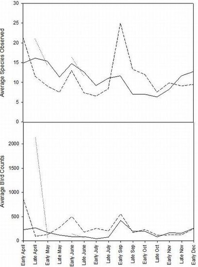
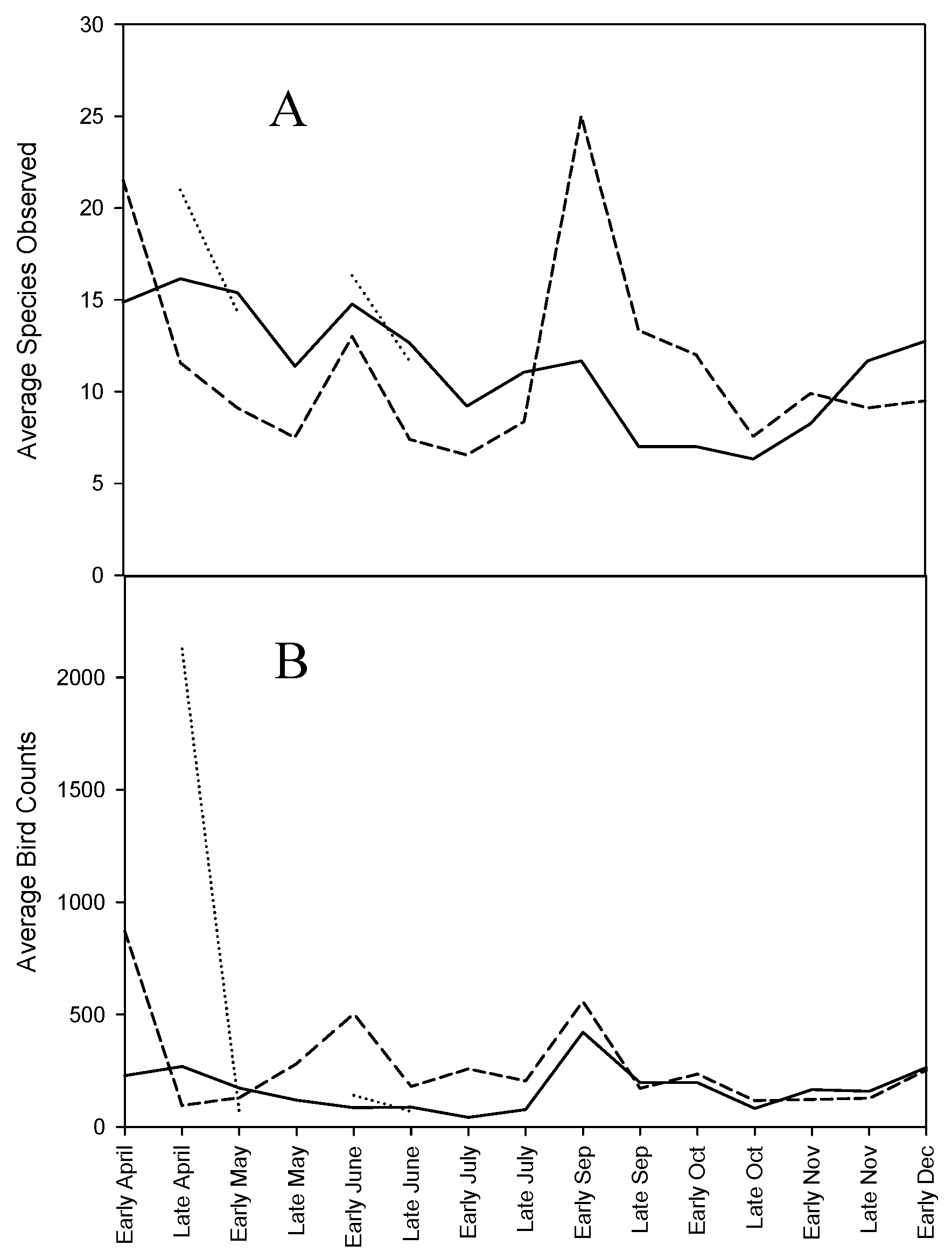
Bird species diversity (measured as the transformed Shannon-Weiner Index) was greater in July than in May at all sites in 2009 (t = −3.56, p = 0.04). In 2008, average species richness in the Sacramento sub-basin peaked in April, while in the Tulare sub-basin, the greatest numbers of species were observed in September (Figure 2A). Average number of birds observed per visit in the Sacramento and Tulare basins was highest in early September, while in the San Joaquin sub-basin the greatest abundance appeared to occur in late April (Figure 2B). For subsequent analyses, birds were categorized into 11 foraging and habitat guilds.
Figure 2. Average number of species and average number of individual birds observed per visit (wetland surveys) in the Sacramento (solid line), San Joaquin (dotted line) and Tulare (dashed line) sub-basins from April to December 2008.
Diversity 04 00396 g002
Hydrology is the single most important determinant of wetland ecosystem function. The presence, depth and duration of water drives plant germination, floristic composition, water chemistry and wildlife use [8,25]. Drastic alterations to the hydrology of the Central Valley have markedly influenced wildlife presence and abundance, however restored wetland habitats may mitigate some of these changes. As in other surveys, bird diversity and abundance peaked in April during spring migration and then again in the late summer and early fall [26], suggestive of historic avian migratory movements through the region. Historically, early migrants would have flown south to the Tulare sub-basin in the late summer and early fall to take advantage of the large lakes and wetlands while the rest of the CCV was relatively dry. This would be followed by a northward migration to the San Joaquin and Sacramento sub-basins as they flooded with winter rain and spring runoff. Once precipitation and flooding filled wetlands of the Sacramento and San Joaquin sub-basins, birds would then move north [3]. Although our data point towards unchanged migration patterns, wintering ground philopatry may negatively impact body condition of individuals and populations if waterfowl continue to revisit heavily altered or degraded wetland habitats, particularly in the southern CCV.
Observed trends suggest that moist soil management techniques that emphasize flooding in the winter and drawdown in spring may not match peak avian abundance in the southern CCV. Flooding in early fall months beginning in September may favor waterfowl use in the Tulare sub-basin and mimic historic water conditions. A slow or delayed drawdown in late spring through early summer may favor breeding shorebirds in the San Joaquin and Tulare sub-basins.
Waterfowl and waterbirds in our study favored diverse sites with multiple habitat types. Incorporating variable topography in the initial design of restored impoundments creates a flooding gradient that favors development of a broader floral community with varying water tolerance. Sites with larger upland habitats favored aerial predators, which may discourage waterfowl and waterbird use.

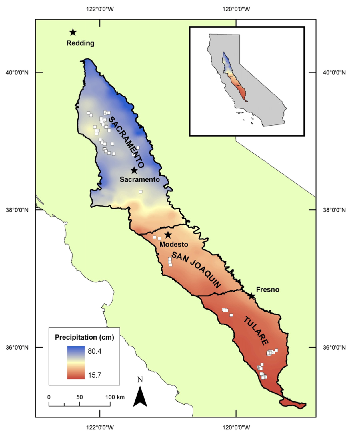
3.3. Effect of Precipitation Gradient on Avian Use

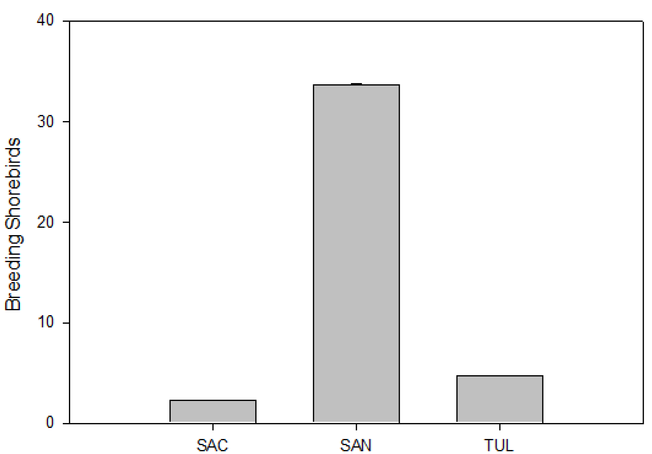
Neither species diversity nor species richness followed a trend along the north-south precipitation gradient. However, species richness was significantly greater in the San Joaquin sub-basin than in other sub-basins (H (2, n = 57) = 8.4, p = 0.01). In 2008, breeding shorebirds were also significantly more abundant in the San Joaquin sub-basin (H (2, n = 33) = 1 2.7, p < 0.01).
Point counts in the upland portions of WRP in the northernmost Sacramento sub-basin, exhibited significantly greater numbers of aerial feeders (H (1, n = 221) = 3.7, p = 0.05) and marsh birds (H (1, n = 221) = 74.2, p < 0.01) than in the San Joaquin sub-basin. Wetland surveys revealed greater numbers of geese in WRPs of the Sacramento sub-basin than either of the sub-basins further south (H (2, n = 61) = 8.5, p = 0.01) (Figure 3) as were dabbling ducks (H (2, n = 61) = 5.7, p = 0.05). Shorebirds (H (2, n = 61) = 5.8, p = 0.05), and marsh birds (H (2, n = 61) = 12.7, p < 0.01) (Figure 3) and breeding shorebirds (H (2, n = 33) = 12.7, p < 0.01) were most abundant in the San Joaquin sub-basin (Figure 4).
Almost all foraging guilds were more abundant in restored wetlands of the northern Sacramento sub-basin compared to the San Joaquin, suggesting a positive relationship between avian use, water availability and associated longer growing seasons. In addition, the Sacramento sub-basin has retained the majority of all remaining upland riparian habitat in the CCV [3] and has large tracts of crops consumed by waterfowl such as rice and corn. Wildlife friendly artificial habitats include aquacultural ponds, rice paddy fields and reservoirs and are known to provide supplementary habitat to waterfowl in degraded landscapes around the world [27]. An abundance of trees within semi-permanent wetlands of the Sacramento valley also contribute to higher avian biodiversity compared to sub-basins further south [12]. Ancillary data suggests both on-site and landscape scale factors play a role in influencing avian occurrence. For instance, more geese were observed on restored sites in the Sacramento sub-basin. Goose presence is often associated with rice and corn crops on the landscape, but may also be linked to on-site habitat characteristics such as wet meadow (moist soil) and open water zones in WRP [13]. Wildlife friendly crops such as rice, small grains and pasture which are attractive to geese are primarily grown in the Sacramento sub-basin. Wet meadow and open water zones were significantly larger on sites in the Sacramento sub-basin than sites further south [13]. Wet meadow zones are typically dominated by short annual wetland species such as grasses (Poaceae spp.), smartweeds (Polygonum spp.) and swamp timothy (Crypsis schoenoides) that may be favored by geese and other grazing birds. Larger wet meadow zones also suggest an emphasis on moist soil management which encourages the germination of annual seed bearing plants for wintering waterfowl.
Figure 3. Average abundance of eight bird foraging guilds observed (wetland surveys) on wetland areas of Wetlands Reserve Program easements in three California Central Valley sub-basins, Sac = Sacramento, San = San Joaquin and Tul = Tulare. The Tulare sub-basin was not sampled in the year 2009. Foraging guilds are comprised of species that share behavioral traits and have similar environmental requirements [13]. Standard error bars are shown.
Diversity 04 00396 g003
Figure 4. Average abundance of shorebirds observed (wetland surveys) on wetland areas of Wetlands Reserve Program easements in three California Central Valley sub-basins, Sac = Sacramento, San = San Joaquin and Tul = Tulare. Standard error bars are shown.
Diversity 04 00396 g004
Aerial predators were more abundant in the Tulare sub-basin compared to the Sacramento or San Joaquin and included species that often prey on wetland birds. Conditions in the drier Tulare sub-basin make wetland management particularly difficult. Heavy reliance on pumped groundwater has resulted in fewer actively managed wetlands and WRP easements with larger upland areas dominated by grasses such as salt grass (Distichlis spicata) and reed-canary grass (Phalaris canariensis). Given unreliable water supplies, pre-irrigated cropland outside of the growing season is often the only alternative for early fall migrants to the Tulare sub-basin. The result has been diminished early season use by waterfowl, particularly after the decline in pre-irrigated cropland in the 1970s. Although initiatives such as the Central Valley Project Improvement Act (CVPIA), which was passed in 1992 increased water reliability to the southern CCV, privately managed wetlands do not benefit directly. Furthermore, with rising population and agricultural demands, it is unlikely that water allocations to wetlands will increase significantly enough to approach historic wetland availability for water dependent species. It is therefore likely that restored habitats in the southern CCV will remain minimally managed or un-managed, providing habitat primarily for upland species and aerial predators whose foraging activity is better suited to open grasslands. However, where water is available, an emphasis on early fall flooding may support waterfowl migrants. Alternatively, encouraging the integration of waterfowl management in surrounding cropland may yield more substantial results.
Marsh birds occurred in greatest abundance in the San Joaquin sub-basin compared to other sub-basins. Marsh birds include Red-winged Blackbirds, Marsh Wrens, American Coots and Common Yellowthroat, among others. Breeding shorebirds were also more abundant in the San Joaquin sub-basin. Greater shorebird species richness has been reported in the San Joaquin Valley [28], however other reports found that the Sacramento and Tulare sub-basins support more shorebirds than the San Joaquin. However, our data suggest that restored wetlands in this region are major shorebird habitats, despite only 50% of land owners managing for shorebirds. The numbers are disproportionately high especially considering the relative size of individual WRP easements and overall acreage in the San Joaquin. We suspect that shorebird and marsh bird abundance may be bolstered by the restored wetlands proximity to the Grasslands Ecological Area (GEA) located in the San Joaquin sub-basin. The GEA is a 64,700 ha mosaic of grassland, riparian and depressional wetlands recognized as a Wetland of International Importance by the Western Hemisphere Shorebird Reserve Network. The GEA supports more shorebirds than any other inland site in North America during winter and spring [3,19] and is one of a few key wintering areas in the world for mountain plovers [29]. Additionally, the location of many privately managed sites within the Grassland Resource Conservation District (GRCD) may enhance their use by birds. The GRCD is a 30,300 ha area and holds 20% of the CCV’s remaining wetlands. About 11,300 ha of the GRCD are protected from development, and are some of the most important wintering waterfowl areas in North America [30].

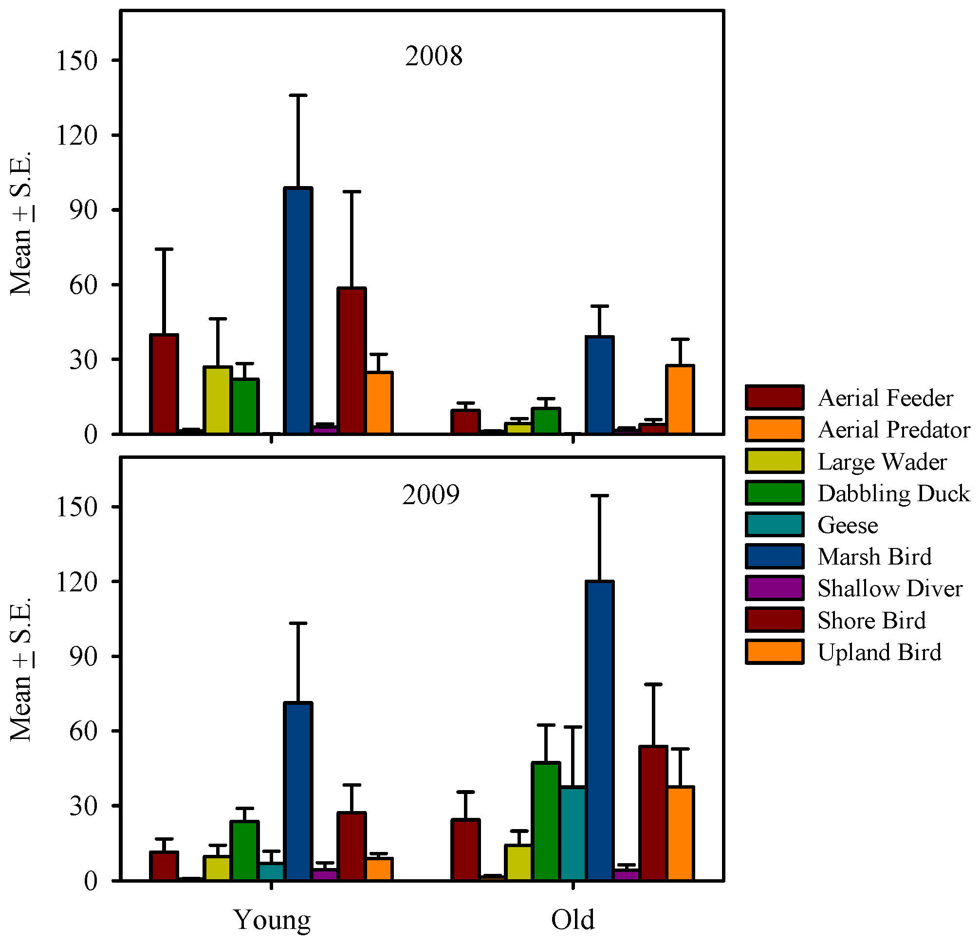
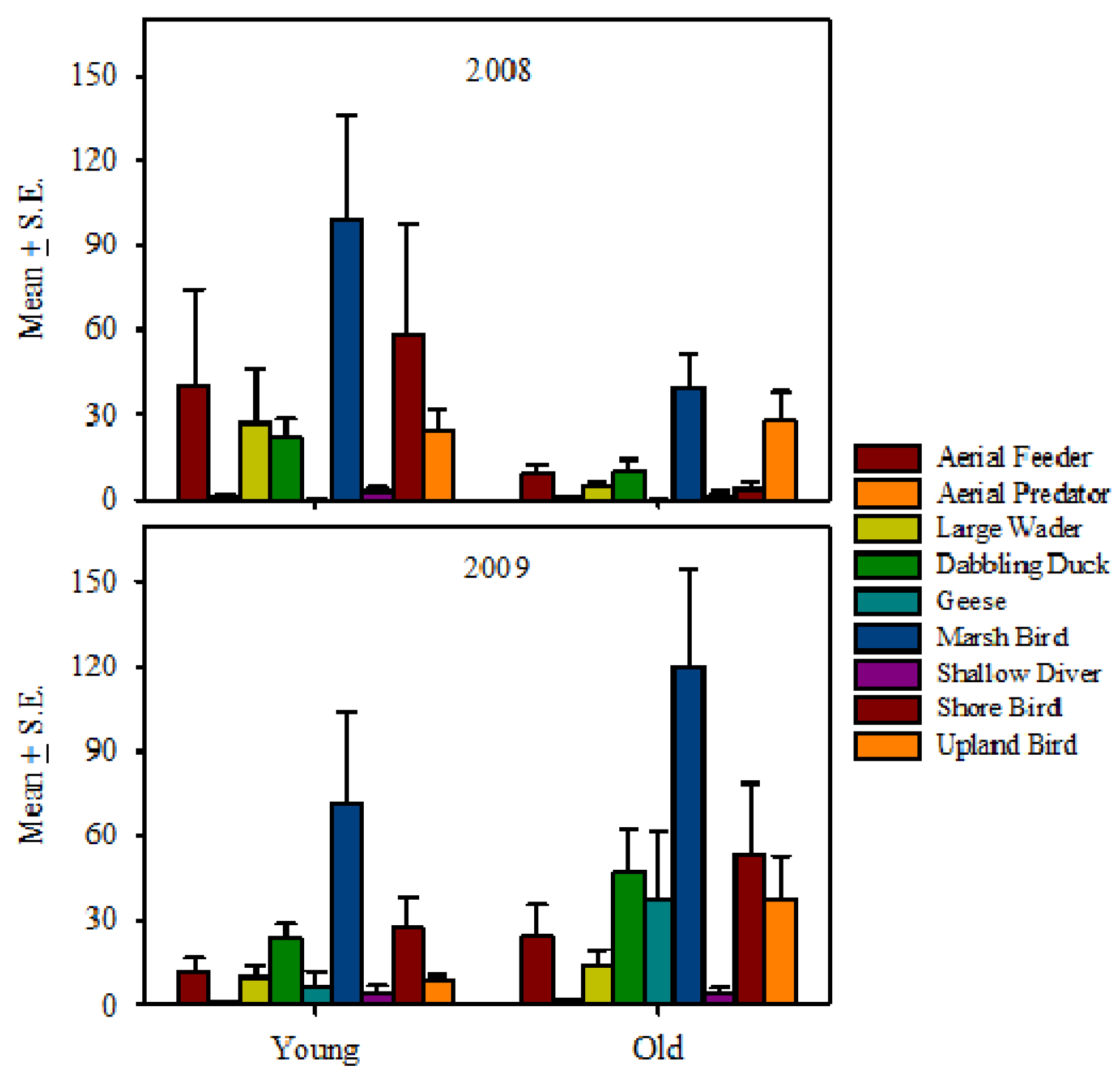
3.4. Effect of Restoration Age on Avian Use

Bird species diversity and richness did not differ with WRP age since restoration. Among guilds, only upland birds were significantly more abundant on older WRPs than on younger WRPs (U (59) = 269.5, Z = −2.28, p = 0.02) (Figure 5). Most guilds were observed more frequently on older WRPs than on younger WRPs. Dabbling ducks, marsh birds, shorebirds and upland birds were observed more frequently on younger rather than older WRP sites (Table 5).
Figure 5. Average abundance of eight bird foraging guilds observed (wetland surveys) on wetland areas of Wetlands Reserve Program easements. 2008 includes Sacramento, San Joaquin, and Tulare sub-basin data, whereas 2009 includes Sacramento and San Joaquin sub-basin data only. “Young” sites are ≤5 years since restoration; “Old” are >5 years. Foraging guilds are comprised of species that share behavioral traits and have similar environmental requirements [13]. Standard error bars are shown.
Diversity 04 00396 g005
Shifts in bird species composition have been observed with increasing wetland age, primarily due to plant establishment and increasing habitat structure [31,32,33]. Wetland physiognomy may be the most important factor influencing total bird diversity. Vegetation growth and management establish the basis of the ecological food web on restored wetlands [34,35]. Although we did not detect any differences in species diversity and foraging guild abundance between younger and older WRP uplands, wetland portions of older WRPs exhibited differences in all guilds with the exception of marsh birds. Upland birds were more abundant on wetlands of older sites and may be linked to the availability and size of riparian habitat on older sites. These findings corroborate that of previous studies, where sites re-vegetated with native plants in the Sacramento River that were greater than five years old, exhibited bird diversity similar to that of remnant woodland [36]. Similarly, in Iowa, the mean number of breeding birds was reported to be significantly higher in older restored wetlands [37] and species richness was reported to increase with percent cover of emergent vegetation.

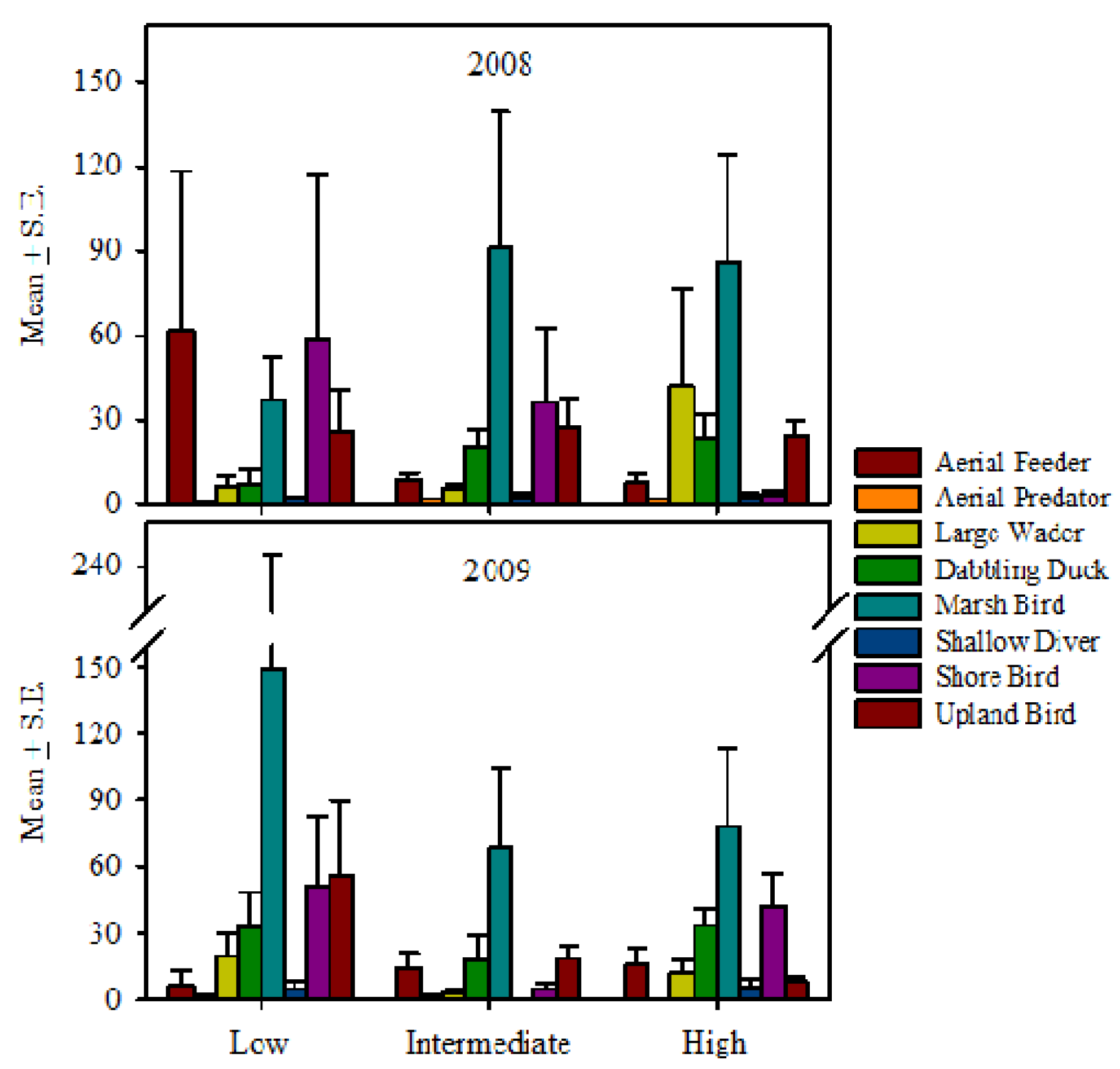
3.5. Effect of Management Intensity on Avian Use

Point counts conducted in the upland portions of WRPs indicated that bird species richness was greater in low management intensity or unmanaged WRPs than on more intensively managed WRP sites (H (2, N = 19) = 6.0, p = 0.05). Uplands of intensively managed WRPs had more upland species than other management regimes (H (2, N = 221) = 16.3, p < 0.01). Wetland surveys revealed more dabbling ducks (H (2, N = 61) = 6.9, p = 0.03), geese (H (2, N = 61) = 7.1, p = 0.03) and aerial feeders (H (2, N = 61) = 5.9, p = 0.05) on intensively managed WRPs than WRPs managed under intermediate or low management intensity regimes (Figure 6). Notably in the Tulare sub-basin, large wading birds were significantly more abundant on intensively managed WRPs (H (2, N = 13) =7.1, p = 0.03). Interestingly, shorebird abundance was greatest on intermediately managed sites (H (2, N = 61) = 8.9, p = 0.01).
Table 5. Percent occurrence of avian foraging guilds in Wetland Reserve Program easements by sub-basin, management and age (2008–2009). Number of sites is indicated in parentheses. Sac = Sacramento sub-basin; San = San Joaquin sub-basin and ; Tul = Tulare sub-basin. “Young” sites are ≤5 years since restoration; “Old” are >5 years. “Low” = sites under low or no management; “Inter” = sites under intermediate management; “High” = actively managed sites. Management categories are described in Experimental Section.
Sub-basin %Management %Age %
SacSanTulLowInterHighYoungOld
Guild(39)(9)(13)(14)(20)(27)(40)(21)
Aerial Feeder95898586959388100
Aerial Predator74100929390708086
Wading Birds7789697175818071
Dabbling Ducks921007779851009090
Geese6456695060746367
Gulls2300715191319
Marsh Birds595602140635333
Plunge Divers4156856465374862
Shallow Divers4644232135564043
Shorebirds72100385065817557
Upland Birds82100544385938371
Figure 6. Average abundance of eight bird foraging guilds observed (wetland surveys) by management intensity on wetland areas of Wetlands Reserve Program easements in California’s Central Valley. 2008 includes Sacramento, San Joaquin, and Tulare sub-basin data, whereas 2009 includes Sacramento and San Joaquin sub-basin data only. Low = sites with low or no management, Intermediate = sites with intermediate management, High = actively managed sites. Foraging guilds are comprised of species that share behavioral traits and have similar environmental requirements [13]. Standard error bars are shown.
Diversity 04 00396 g006
Aerial feeders, marsh birds and upland birds were more abundant on heavily managed sites. All foraging guilds except upland birds were observed more frequently on actively managed sites. Although species diversity and richness did not differ statistically among management regimes, data indicate an increasing trend from low to high management.
As expected, actively managed restored wetlands supported more dabbling ducks. Actively managed sites have more dynamic hydrological regimes and many are managed specifically to attract wintering waterfowl. The largest proportion of actively managed sites was located in the Sacramento sub-basin [13]; however, sites in the Tulare sub-basin may receive more use by waterfowl, waterbirds and shorebirds because alternative habitats were lacking. Geese and shallow divers were also more abundant on actively managed WRP easements.
Low and intermediate management may benefit non-waterfowl species. Less than half of all WRPs are not actively drawn down and therefore allow water to evaporate slowly. This strategy mimics historic conditions in the CCV, when slow evaporation of wetlands would occur over the summer following winter and spring flooding. This would have provided shallow ponds for breeding shorebirds. Not all active management practices are beneficial to birds. Most actively managed sites are mowed and disked to control weeds and create open water areas for wintering waterfowl. Increased disturbance due to vegetation and pest control may encourage predation by creating corridors in otherwise dense vegetation stands. Spraying for mosquitoes may also inadvertently impact invertebrate communities typically consumed by waterfowl. Waterfowl typically increase intake of invertebrates in their diets in the late winter as they prepare to migrate back to breeding grounds. While spraying was not widespread in the Sacramento and San-Joaquin sub-basins, almost half the sites in the Tulare sub-basin are sprayed.

3.6. Site Characteristics

Sites in the Tulare sub-basin exhibited significantly larger upland zones, followed by the San Joaquin and Sacramento sub-basins (H (2, N = 43) = 12.2, p = 0.02). Wet meadow zones dominated by annual, flood tolerant species and the open water zone were significantly larger in the Sacramento sub-basin (H (2, N = 43) = 14.7, p < 0.01). Wetland zones did not differ by management. Younger sites exhibited larger upland zones (t (41) = −2.19, p = 0.03), while older sites had significantly larger wet meadow (t (41) = −2.03, p = 0.05) and shallow marsh zones (t (41) = −2.36, p = 0.01).
We identified correlations between avian guilds and available proportions of different habitats on WRP. Avian guilds exhibited differences in their relationships to the proportion of restored wetland habitat (Table 6). Spearman rank order correlation coefficients were significant at p = 0.05. Marsh birds, wading birds, dabbling ducks, shorebirds and shallow divers were positively correlated to the number of wetland zones present indicating an affinity for wetlands with diverse flora. Diving ducks, shorebirds, geese and shallow divers were positively related to wetland depth, while aerial predators were negatively related to wetland depth. Geese were negatively related to proportion of upland, while aerial predator numbers increased with upland proportion. Proportions of wet meadow were positively correlated to plunge divers, but negatively correlated to marsh birds, diving ducks, aerial predators and upland birds. Marsh birds, wading birds, dabbling ducks, diving ducks, shallow divers and upland birds were all positively correlated to the proportion of shallow marsh and deep marsh. Dabbling ducks, diving ducks, shorebirds, geese and shallow divers were positively correlated to open water, however aerial predators were negatively correlated to open water.
Table 6. Spearman Rank Order correlation coefficients among avian guilds and habitat characteristics surveyed in 2008 and 2009. Correlation coefficients shown are significant at p = 0.05.
ZonesDepthUplandWet MeadowShallow EmergentDeep EmergentOpen Water
Marsh Birds0.39--−0.310.430.38-
Wading Birds0.38---0.470.24-
Dabbling Ducks0.44--−0.340.420.370.26
Shorebirds0.360.46----0.28
Geese-0.27-0.28---0.34
Aerial Feeders-------
Aerial Predators-−0.240.49−0.37-0.38−0.43
Shallow Divers0.320.27--0.320.260.41
Plunge Divers---0.25---
Upland Birds---−0.340.280.27-

4. Conclusions

Avian occurrence in the CCV varies spatially and seasonally depending on life history requirements and resource availability. Prior to this study, the extent of use of WRP by non-wetland dependent avian fauna was unknown. Our surveys indicate that WRP easements support a diverse assemblage of avian species that are representative of the CCV as a whole. In addition to waterfowl and waterbirds, we recorded over 90 species using upland habitats including aerial predators. Of these, over 15 were special status species. Acknowledging and understanding the important role that these restored habitats play to non-wetland dependent birds may help raise the profile of restoration programs in the CCV by broadening their potential ecological functions. Our study shows that WRP provides habitat to more species than was previously known, even under conditions of inadequate hydrology.
Despite reported water shortages, greater upland and un-restored acreage in the southern CCV (Tulare sub-basin), WRP provides critical waterfowl habitat, particularly in the early fall months. Restored WRP sites in the Tulare sub-basin are islands of hydrology in a vast matrix of cropland. The Tulare sub-basin is recognized as one of the most important areas for breeding shorebirds and waterfowl in summer and early fall [19], however, in winter most birds move north to the Sacramento and San Joaquin sub-basins in the winter where water is more reliable and alternative habitat such as rice fields supplement wetlands [38]. Waterfowl and waterbirds are also known to use post-harvest flooded and irrigated cropland in the Tulare sub-basin [20] however; it was unclear whether birds from restored WRP migrate to adjacent croplands. A recent study of avian use of flooded and irrigated cropland [20] yielded an almost identical waterfowl species assemblage, but less than half the number of waterbirds and a quarter of the non-wetland birds as this study. In the San Joaquin sub-basin, the Central Valley Project Improvement Act increased reliability of water supplies for public and private wetlands. Improved access to water resources for hydrological management would greatly enhance waterfowl use in the Tulare and financial support may be available through initiatives like the California Department of Fish and Game Landowner Incentive Program. Nonetheless, water shortages in the CCV are expected to increase with population growth. The human population of the CCV is projected to more than double by 2040, resulting in losses in irrigated farmland oftentimes used by waterfowl [3]. In addition to water shortages, poor water quality due to reuse of agricultural drain water has often posed a threat to wildlife in the CCV. Salt toxicosis and dangerously high selenium levels are just two problems that have been reported in the San Joaquin sub-basin [39]. Further research should address the effects of hydrological management regimes and water quality on avian use of restored wetlands in the CCV. Changes in habitat availability or structure due to flooding regimes may affect site occupancy [40], therefore understanding how these changes arise could provide options to managers faced with uncertain water access. An assessment of the influence of surrounding land use should also be conducted to evaluate potential influence on site use and to optimize site management for specific guilds or species.

Appendix

Table A. Five most abundant avian species within each guild observed using Wetland Reserve Program easements (2008–2009).
GuildSpecies nameCommon name2008Species nameCommon name2009
Percent Occurrence Percent Occurrence
Aerial FeederTyrannus verticalisWestern Kingbird73Tyrannus verticalisWestern Kingbird92
Petrochelidon pyrrhonotaCliff Swallow71Petrochelidon pyrrhonotaCliff Swallow75
Tachycineta bicolorTree Swallow65Hirundo rusticaBarn Swallow58
Hirundo rusticaBarn Swallow35Tachycineta bicolorTree Swallow58
Aerial PredatorCircus cyaneusNorthern Harrier65Buteo jamaicensisRed-tailed Hawk75
Lanius ludovicianusLoggerhead Shrike38Lanius ludovicianusLoggerhead Shrike67
Petrochelidon pyrrhonotaCliff Swallow71Buteo swainsoniSwainson's Hawk58
Hirundo rusticaBarn Swallow35Circus cyaneusNorthern Harrier50
Large WaderArdea albaGreat Egret79Ardea herodiasGreat Blue Heron75
Ardea herodiasGreat Blue Heron73Ardea albaGreat Egret67
Egretta thulaSnowy Egret65Egretta thulaSnowy Egret50
Plegadis chihiWhite-faced Ibis54Plegadis chihiWhite-faced Ibis50
Dabbling DuckAnas platyrhynchosMallard88Anas platyrhynchosMallard92
Anas cyanopteraCinnamon Teal69Anas cyanopteraCinnamon Teal67
Anas streperaGadwall67Anas streperaGadwall67
Anas clypeataNorthern Shoveler52Anas creccaGreen-winged Teal58
Anas clypeataNorthern Shoveler58
Marsh BirdAgelaius phoeniceusRed-winged Blackbird94Cistothorus palustrisMarsh Wren92
Cistothorus palustrisMarsh Wren79Agelaius phoeniceusRed-winged Blackbird92
Fulica americanaAmerican Coot77Fulica americanaAmerican Coot75
Geothlypis trichasCommon Yellowthroat50Botaurus lentiginosusAmerican Bittern58
Geothlypis trichasCommon Yellowthroat58
Geese/SwanBranta canadensisCanada Goose17Branta canadensisCanada Goose42
Anser albifronsGreater White-fronted Goose6Gallinula chloropusCommon Moorhen33
Chen rossiiRoss's Goose2Rallus limicolaVirginia Rail33
Chen caerulescensSnow Goose2Anser albifronsGreater White-fronted Goose25
Porzana carolinaSora25
GullLarus californicusCalifornia Gull2Larus delawarensisRing-billed Gull17
Larus argentusHerring Gull2Ixobrychus exilisLeast Bittern17
Larus delawarensisRing-billed Gull2Agelaius tricolorTricolored Blackbird*8
Larus Unidentified Gull0Podilymbus podicepsPied-billed Grebe58
Surface DiverPodilymbus podicepsPied-billed Grebe48Oxyura jamaicensisRuddy Duck33
Pelecanus erythrorhynchosAmerican White Pelican25AechmorphusUnid. Clark or Western Grebe8
Oxyura jamaicensisRuddy Duck21Bucephala albeolaBufflehead8
Phalacrocorax auritusDouble-crested Cormorant17Aechmophorus clarkiiClark's Grebe8
Aechmophorus occidentalisWestern Grebe8
Plunge DiverSterna forsteriForster's Tern17Ceryle alcyonBelted Kingfisher8
Ceryle alcyonBelted Kingfisher10
Sterna caspiaCaspian Tern8
Pandion haliaetusOsprey4
ShorebirdCharadrius vociferusKilldeer79Charadrius vociferusKilldeer83
Calidris minutillaLeast Sandpiper50Himantopus mexicanusBlack-necked Stilt75
Himantopus mexicanusBlack-necked Stilt48Tringa melanoleucaGreater Yellowlegs58
Limnodromus Unidentified Dowitcher42Recurvirostra americanaAmerican Avocet50
Calidris minutillaLeast Sandpiper50
Upland BirdSturnella neglectaWestern Meadowlark79Molothrus aterBrown-headed Cowbird100
Melospiza melodiaSong Sparrow77Zenaida macrouraMourning Dove92
Phasianus colchicusRing-necked Pheasant67Phasianus colchicusRing-necked Pheasant92
Molothrus aterBrown-headed Cowbird65Melospiza melodiaSong Sparrow*92

Acknowledgments

We thank all participating landowners and land managers for their generous cooperation, and staff of the Colusa, Kern, Pixley, Sacramento and San Joaquin National Wildlife Refuges provided access and assistance. We also thank the following for their support and guidance: Diane Eckles and William Effland (U.S. Department of Agriculture, Natural Resources Conservation Service (NRCS) CEAP-Wetlands Program), Jessica Groves (National Wetlands Reserve Program (WRP)/Floodplain Easement Manager, formerly NRCS California Wetlands Coordinator), NRCS field office staff, Catherine Hickey (PRBO Conservation Science), Geoffrey Geupel (PRBO Conservation Science), Dean Kwasny and Marc Kenyon (CDFG Landowner Incentive Program) , Deb Schlafman (USFWS—Partners for Fish and Wildlife Program), Alan Forkey (NRCS), Beth Werner, Shannon Chapin, Mary Burke and Bryan Atkinson. Funding for this research was provided by the NRCS Conservation Effects Assessment Project (CEAP)-Wetlands. This is PRBO Conservation Science contribution number 1888. Mention of trade names or products is for descriptive purposes only and does not imply endorsement by the U.S. Geological Survey.

References

  1. Millennium Ecosystem Assessment, Ecosystems and Human Well-being: Wetlands and Water Synthesis; World Resources Institute: Washington, DC, USA, 2005; pp. 3–4.
  2. Dahl, T.E.; Johnson, C.E. Wetlands-Status and Trends in the Conterminous United States, Mid-1970's to Mid-1980’s; Fish and Wildlife Service: Washington, DC, USA, 1991; pp. 12–13. [Google Scholar]
  3. Central Valley Joint Venture, Central Valley Joint Venture implementation plan—conserving bird habitat; U.S. Fish and Wildlife Service: Sacramento, CA, USA, 2006; p. 261.
  4. Hundley, N., Jr. The Great Thirst-Californians and Water, 1700's-1990's; University of California Press: Berkeley, CA, USA, 1992; p. 551. [Google Scholar]
  5. Gilmer, D.S.; Miller, M.R.; Bauer, R.D.; LeDonne, J.R. California’s Central Valley Wintering Waterfowl: Concerns and Challenges. In Transactions of the Forty-seventh North American Wildlife and Natural Resources Conference, Portland, OR, USA; Sabol, K., Ed.; Kenneth Sabol, U.S. Fish and Wildlife Service Publications: Washington, DC, USA, 1982; p. 41. [Google Scholar]
  6. Gray, R.L. Wetlands Reserve Program: a partnership to restore wetlands and associated habitats, 2005, US. Forest Service, General Technical Report PSW-GTR-191. Available online: http://www.fs.fed.us/psw/publications/documents/psw_gtr191/psw_gtr191_1189-1189_gray.pdf 1 March 2009.
  7. Zedler, J.B. Wetlands at your service: reducing impacts of agriculture at the watershed scale. Frontiers in Ecology and the Environment 2003, 1, 65–72. [Google Scholar] [CrossRef]
  8. Mitsch, W.J.; Gosselink, J.G. Wetlands, 4th ed; John Wiley & Sons, Inc.: New York, NY, USA, 2007; pp. 107–161. [Google Scholar]
  9. Valente, J.J.; King, S.L.; Wilson, R. Distribution and habitat associations of breeding secretive marsh birds in Louisiana’s Mississippi Alluvial Valley. Wetlands 2011, 31, 1–10. [Google Scholar]
  10. Evans-Peters, G.R.; Dugger, B.D.; Petrie, M.J. Plant Community Composition and Waterfowl Food Production on Wetland Reserve Program Easements Compared to Those on Managed Public Lands in Western Oregon and Washington. Wetlands 2012, 32, 391–399. [Google Scholar] [CrossRef]
  11. Lor, S.; Malecki, R.A. Breeding ecology and nesting habitat associations of five marsh bird species in western New York. Waterbirds 2006, 29, 427–436. [Google Scholar] [CrossRef]
  12. Harris, P.D. Bird Community Patterns of Spring-Seasonal and Semi-Permanent Wetlands in the Sacramento Valley, California. M. Sc. Thesis, Oregon State University, Corvallis, OR, USA, 2001. [Google Scholar]
  13. Duffy W.G.;, Kahara; S.N.; Records, R.M. (Eds.) Conservation Effects Assessment Project—Wetlands assessment in California’s Central Valley and Upper Klamath River Basin. U.S. Geological Survey Open-File Report, 2011, 2011–1290. Available online: http://pubs.usgs.gov/of/2011/1290/ (accessed on 8 August 2012).
  14. Schoenherr, A.A. A Natural History of California; University of California Press: Berkeley, CA, USA, 1992; p. 518. [Google Scholar]
  15. Ralph, C.J.; Droege, S.; Sauer, J.R. Monitoring Bird Populations by Point Counts, 1995, U.S. Forest Service, General Technical Report PSW-GTR-149, Albany, California. Available online: http://www.fs.fed.us/psw/rsl/projects/wild/gtr149/gtr_149.html/ (accessed on 15 November 2009).
  16. Reed, J.M.; Warnock, N.; Oring, L.W. Censusing shorebirds in the western Great Basin of North America. Int. Wader Stud. 1997, 9, 29–36. [Google Scholar]
  17. Binford, L.C. Checklist of California birds 1986. Western Birds 1986, 17, 1–16. [Google Scholar]
  18. Engilis, A., Jr. Wildlife Resources of the Central Valley, California, Birds—Part 2: Permanent and Summer Residents, 1995, Valley Habitats Technical Series Number 5. Ducks Unlimited, Inc.: Sacramento, California. Available online: http://ceres.ca.gov/ceres/calweb/DU/Valley_Habitats2.html/ (accessed on 15 June 2010).
  19. Hickey, C.; Wood, J.; Stenzel, L.; DiGaudio, R.; Page, G.; Culp, L.; Tonra, C.; Kreitinger, K.; Geupel, G. Avian Monitoring on Private Lands: Measuring Bird Response to Easement, Restoration, Enhancement, and Incentive Programs in the Central Valley, 2004–2006; PRBO Conservation Science: Petaluma, CA, USA, 2008. [Google Scholar]
  20. Fleskes, J.P.; Skalos, D.A.; Farinha, M.A. Bird use of fields treated postharvest with two types of flooding in Tulare basin, California. JFWM 2012, 3, 164–174. [Google Scholar]
  21. California Bird Species of Special Concern: A ranked assessment of species, subspecies, and distinct populations of birds of immediate conservation concern in California. In Studies of Western Birds No.1, Western Field Ornithologists, Camarillo, California; Shuford, W.D.; Gardali, T. (Eds.) USA and California Department of Fish and Game: Sacramento, CA, USA, 2008; Volume 1, pp. 67–444.
  22. California Department of Fish and Game. State and federally listed endangered and threatened animals of California. California Department of Fish and Game, 2009. Available online: http://www.dfg.ca.gov/biogeodata/cnddb/pdfs/TEAnimals.pdf (accessed on 10 December 2009).
  23. U.S. Fish and Wildlife Service. Birds of Conservation Concern 2008. U.S. Fish and Wildlife Service, Division of Migratory Bird Management, Arlington, Virginia, USA, 2008. Available online: http://www.fws.gov/migratorybirds/ (accessed on 13 March 2008).
  24. International Union for Conservation of Nature. 2006 IUCN Red List of Threatened Species, 2006. Available online: http://www.iucnredlist.org/ (accessed on 1 March 2008).
  25. Euliss, N.D., Jr.; LaBaugh, J.W.; Fredrickson, L.H.; Mushet, D.M.; Laubhan, M.K.; Swanson, G.A.; Winter, T.C.; Rosenberry, D.O.; Nelson, R.D. The wetland continuum: A conceptual framework for interpreting biological studies. Wetlands 2004, 24, 448–458. [Google Scholar] [CrossRef]
  26. Gilmer, D.S.; Gonzales, K.A.; Wolder, M.A.; Graves, N.R. Nongame and upland gamebird surveys on Sacramento Valley National Wildlife Refuges, 1986–1993. W. Birds 1998, 29, 83–102. [Google Scholar]
  27. Ma, Z.; Yinting, C.; Li, B.; Chen, J. Managing wetland habitats for waterbirds: An international perspective. Wetlands 2010, 30, 15–27. [Google Scholar]
  28. Shuford, W.D.; Page, G.W.; Kjelmyr, J.E. Patterns and dynamics of shorebird use of California’s Central Valley. Condor 1998, 100, 227–244. [Google Scholar]
  29. Knopf, F.L.; Rupert, J.R. Habits and habitats of Mountain Plovers in California. Condor 1995, 97, 743–751. [Google Scholar]
  30. California Association of Resource Conservation Districts. Grassland Resource Conservation District: California Association of Resource Conservation Districts, 2010. Available online: http://www.carcd.org/directory.php?rcdid=489/ (accessed on 16 September 2011).
  31. Losito, M.P.; Baldassarre, G.A. Wetland use by breeding and postbreeding female mallards in the St. Laurence river valley. Wilson Bulletin 1995, 107, 55–63. [Google Scholar]
  32. Froneman, A.; Mangnall, M.J.; Little, R.M.; Crowe, T.M. Waterbirds assemblages and associated habitat characteristics of farm ponds in the Western Cape, South Africa. Biodivers. Conserv. 2001, 10, 251–270. [Google Scholar]
  33. Erwin, R.M.; Beck, R.A. Restoration of waterbird habitats in Chesapeake Bay: great expectations or Sisyphus revisited? Waterbirds 2007, 30, 163–176. [Google Scholar]
  34. Matthews, J.W.; Endress, A.G. Performance criteria, Compliance success, and vegetation development in compensatory mitigation wetlands. Environ. Manage. 2008, 41, 130–141. [Google Scholar]
  35. Davis, C.A.; Bidwell, J.R. Response of aquatic invertebrates to vegetation management and agriculture. Wetlands 2008, 28, 793–805. [Google Scholar]
  36. Golet, G.H.; Brown, D.L.; Crone, E.E.; Geupel, G.R.; Greco, S.E.; Holl, K.D.; Jukkola, D.E.; Kondolf, G.M.; Larsen, E.W.; Ligon, F.K.; et al. Using science to evaluate restoration efforts and ecosystem health on the Sacramento River Project, California. In California Riparian Systems: Processes and Floodplain Management, Ecology and Restoration, Riparian Habitat and Floodplains Conference Proceedings, Sacramento, CA, USA, 2001; Faber, P.M., Ed.; Riparian Habitat Joint Venture: Sacramento, CA, USA, 2003; pp. 368–385. [Google Scholar]
  37. VanRees-Siewert, K.L.; Dinsmore, J.J. Influence of wetland age on bird use of restored wetlands in Iowa. Wetlands 1996, 16, 577–582. [Google Scholar]
  38. Manolis, T.; Tangren, G.V. Shorebirds of the Sacramento Valley, California. Western Birds 1975, 6, 45–54. [Google Scholar]
  39. Wu, L. Review of 15 years of research on ecotoxicology and remediation of land contaminated by agricultural drainage sediment rich in selenium. Ecotoxicology 2004, 57, 257–269. [Google Scholar]
  40. Benson, T.J.; Bednarz, J.C. Short-term effects of flooding on understory habitat and presence of Swainson’s Warblers. Wetlands 2010, 30, 29–37. [Google Scholar]

