Loss of European Dry Heaths in NW Spain: A Case Study

Abstract
:
1. Introduction

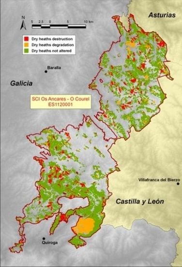
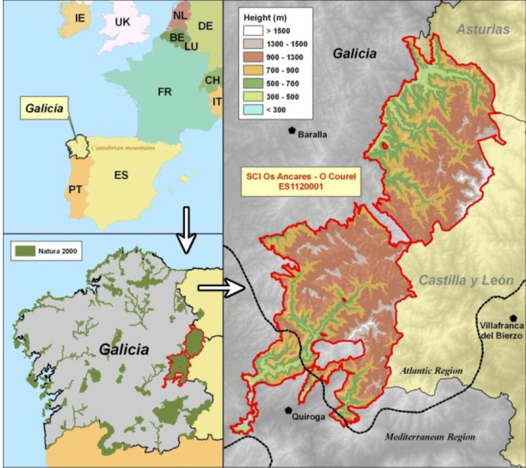
2. Study Area
3. Methodology and Datasets
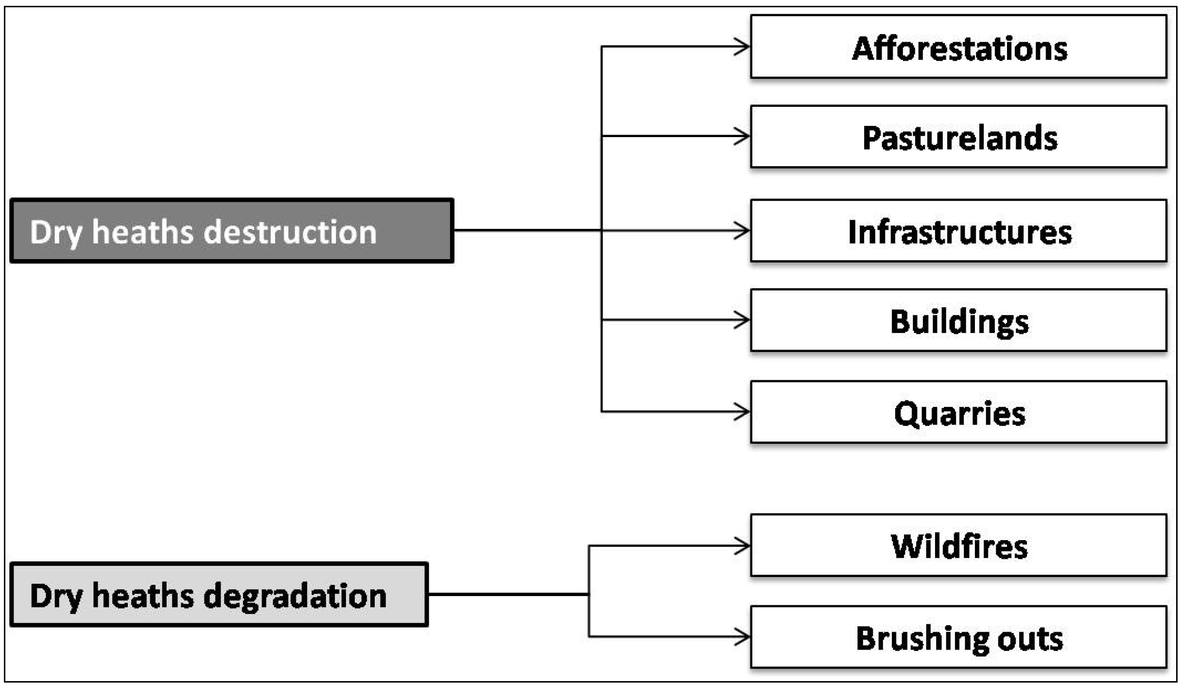
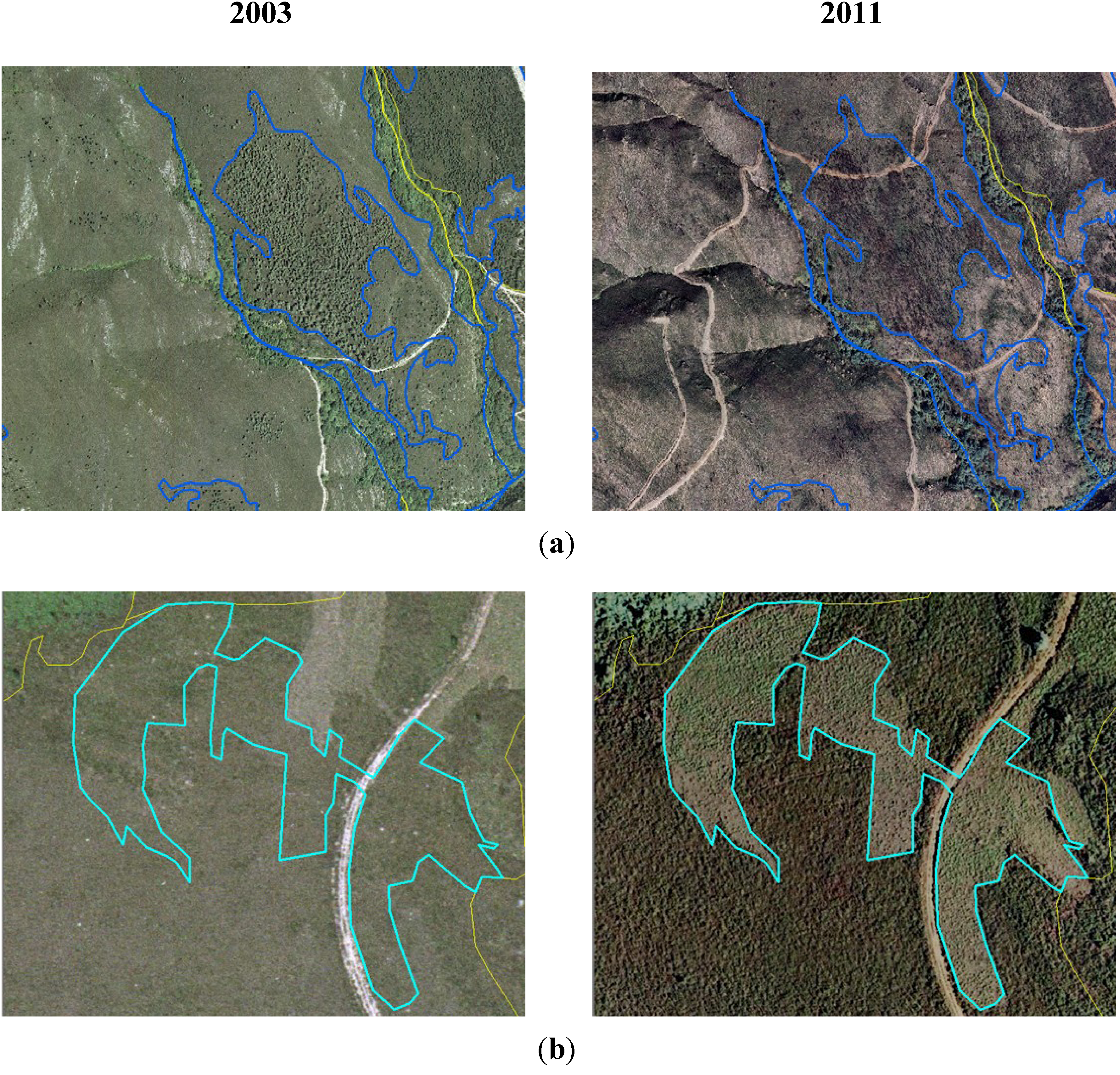
- Afforestations: in a first step these include removal of heath by using forestry brush slashers or shredders, followed by ripping soil in down-slope direction forin-row planting exotic tree species (Pinus spp., Eucalyptus spp, Pseudotsuga menziesii, Quercus rubra, Castanea × coudercii).
- Pasturelands: these comprise transformation of dry heathland by removal of heath and the preparation of topsoil by ploughing, milling and liming. Genetically selected strains of species of grazing interest of the genera Lolium, Dactylis and Trifolium are mainly sowed.
- Infrastructures: these include construction of roads, forest tracks, firebreaks and both power and data transmission lines, with destruction of the preexisting dry heath.
- Buildings: construction of buildings on the areas occupied by dry heaths.
- Quarries: this cause includes all actions related with opencast slate (opening the craters, tailings facility, access roads, settling basins, etc.), which it is a very common industrial activity in the area.
- Wildfires: comprise those changes in structure and density of dry heath vegetation due to its combustion.
- Brushing outs: in these areas there has been a change in the structure and density of dry heath through slashing or shredding not followed by a tree plantation. These brushing outs have different purposes: feeding hunting species such as partridges (Alectoris rufa), to favor the blueberry bushes (Vaccinium myrtillus) which serves as food for brown bear (Ursus arctos).

4. Results


| Changes | Tiles | Area (ha) | Habitat Percentage | Mean (ha) | Minimum (ha) | Maximum (ha) |
|---|---|---|---|---|---|---|
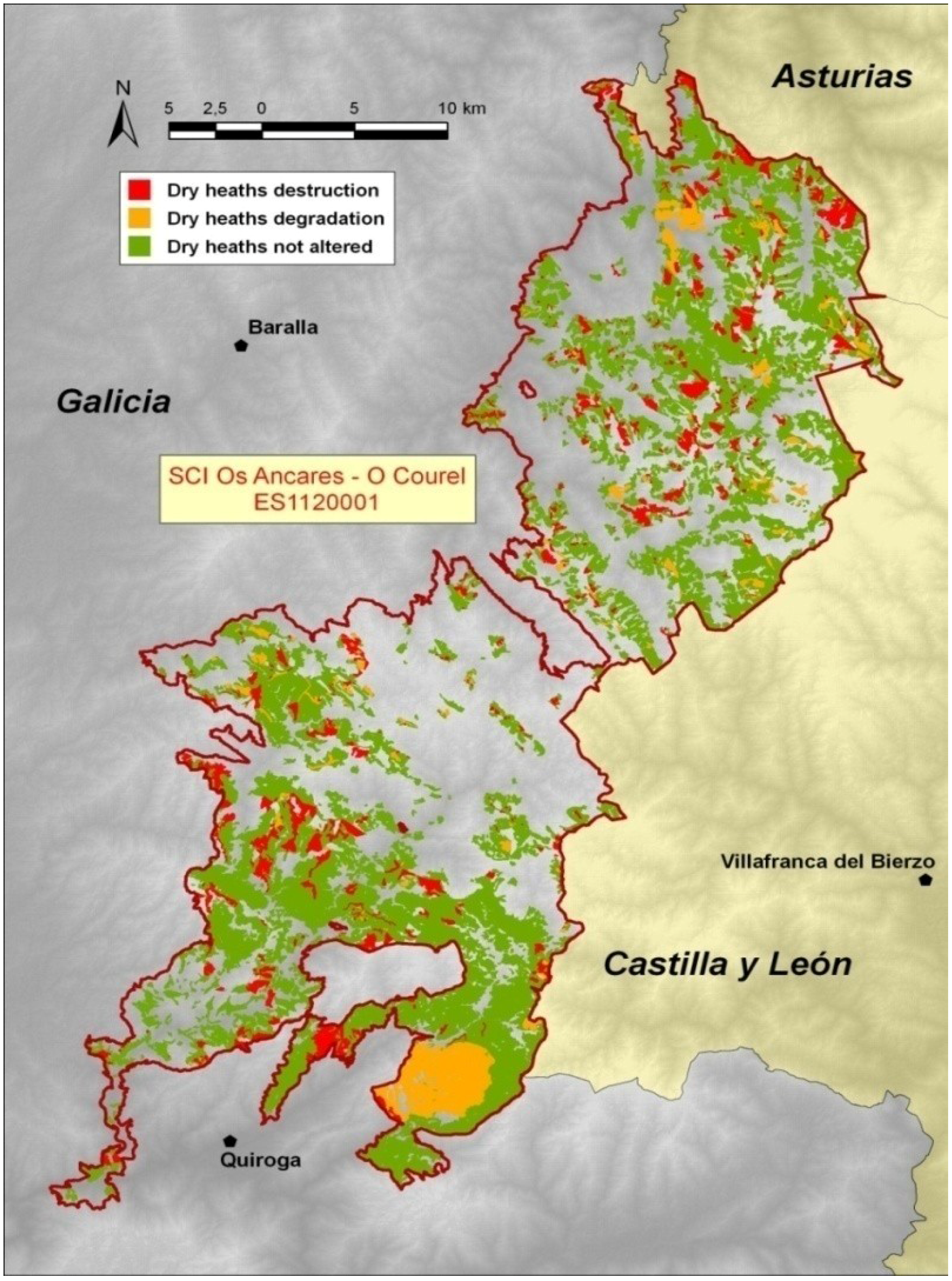
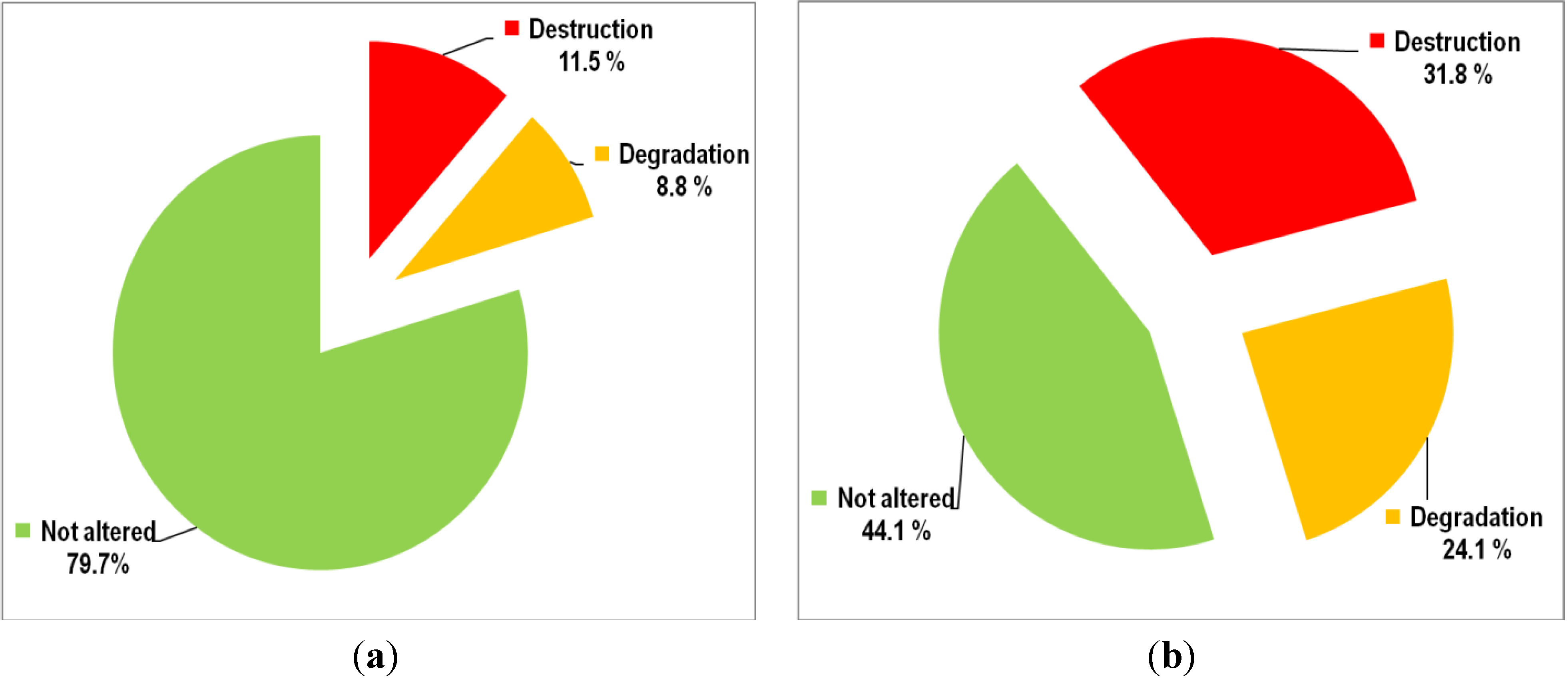
| Dry heaths destruction | 840 | 4,018.4 | 11.5% | 4.8 | <0.1 | 135.8 |
| Dry heaths degradation | 363 | 3,047.9 | 8.8% | 8.4 | <0.1 | 811.9 |
| TOTAL | 1,203 | 7,066.3 | 20.3% | 5.9 | <0.1 | 811.9 |
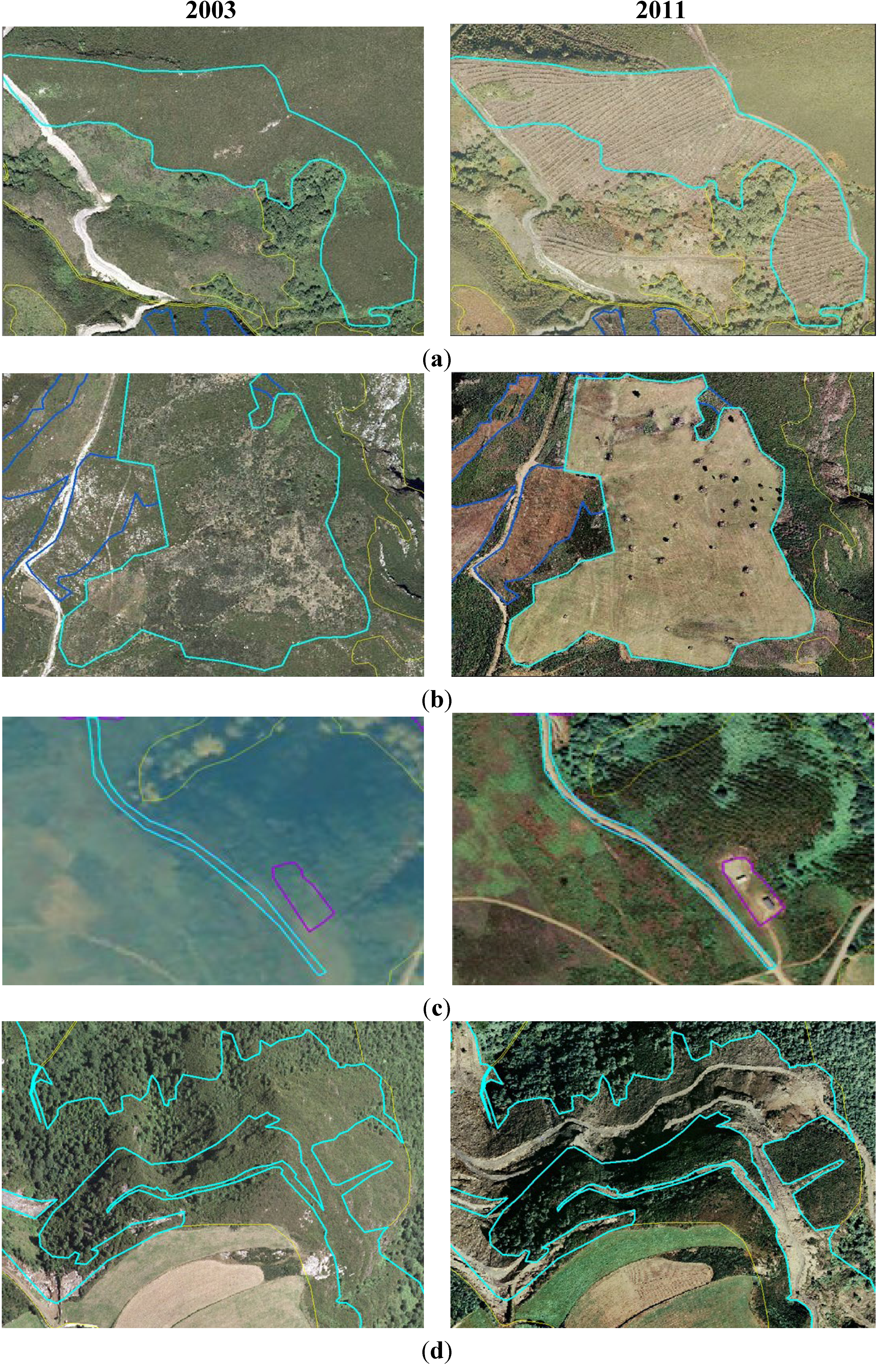
4.1. Dry Heaths Destruction (2003–2011)
4.1.1. Afforestations
| Tiles | Area (ha) | Habitat Percentage | Destruction Percentage | Mean (ha) | Minimum (ha) | Maximum (ha) | |
|---|---|---|---|---|---|---|---|
| Afforestations | 425 | 3,534.9 | 10.2% | 88.0% | 8.3 | 0.1 | 135.8 |
| Pasturelands | 357 | 435.7 | 1.2% | 10.8% | 1.2 | <0.1 | 18.3 |
| Infrastructures | 56 | 38.4 | 0.1% | 1.0% | <0.1 | <0.1 | 5.4 |
| Buildings | 1 | 0.1 | <0.1% | <0.1% | 0.1 | 0.1 | 0.1 |
| Quarries | 1 | 9.3 | <0.1% | 0.2% | 9.3 | 9.3 | 9.3 |
| TOTAL | 840 | 4,018.4 | 11.5% | 100.0% | 4.8 ha | <0.1 | 135.8 |
4.1.2. Pasturelands
4.1.3. Other Causes of Destruction
4.2. Dry Heaths Degradation (2003–2011)
| Tiles | Area (ha) | Habitat Percentage | Degradation Percentage | Mean (ha) | Minimum (ha) | Maximum (ha) | |
|---|---|---|---|---|---|---|---|
| Wildfires | 35 | 2,286.2 | 6.6% | 75.0% | 65.3 | 0.2 | 811.9 |
| Brushing outs | 328 | 761.7 | 2.2% | 25.0% | 2.3 | <0.1 | 29.3 |
| 363 | 3,047.9 | 8.8% | 100.0% | 8.4 | <0.1 | 811.9 |
4.2.1. Wildfires
4.2.2. Brushing Outs
4.3. Dry Heaths Fragmentation (2003–2011)
| Patches | Average size (ha) | Maximum size (ha) | Edge (km) | ANN | |
|---|---|---|---|---|---|
| 2003 | 1,543 | 25.7 | 2,690.2 | 5,948.1 | 1.43 |
| 2011 | 1,730 | 18.8 | 1,840.6 | 6,210.0 | 1.58 |
4.4. Future Projection (until 2025)
| Area 2003–2011(ha) | Annual average (ha) | Projection 2003–2025 (ha) | Lost Habitat 2003–2025(%) | |
|---|---|---|---|---|
| Dry heaths destruction | 4,018.4 | 502.3 | 11,050.7 | 31.8 |
| Dry heaths degradation | 3,047.9 | 338.7 | 8,381.7 | 24.1 |
| DRY HEATHS LOSS | 7,066.3 | 785.1 | 19,432.4 | 55.9 |

5. Discussion
5.1. Methodological Issues
5.2. Dry Heaths Destruction
5.3. Dry Heaths Degradation
5.4. Dry Heaths Loss

5.5. Fragmentation and Connectivity
5.6. Trends and Future Challenges
6. Conclusions
Conflicts of Interest
References
- Díaz González, T.E. Síntesis de la vegetación arbustiva de Europa occidental. I: Brezales (Calluno-Ulicetea). (In Spanish)Itinera geobotanica 1998, 11, 7–31. [Google Scholar]
- Loidi, J.; Biurrun, I.; Campos, J.A.; García-Mijangos, I.; Herrera, M. A survey of heath vegetation of the Iberian Peninsula and Northern Morocco: A biogeographical and bioclimatic approach. Phytocoenologia 2007, 37, 341–370. [Google Scholar] [CrossRef]
- Loidi, J.; Biurrun, I.; Campos, J.A.; García-Mijangos, I.; Herrera, M. A biogeographical analysis of the European Atlantic lowland heaths. J. Veg. Sci. 2010, 21, 832–842. [Google Scholar] [CrossRef]
- Ojeda, F. 4030 Brezales Secos Europeos. In Bases Ecológicas Preliminares Para la conservación de los Tipos de Hábitat de Interés Comunitario en España; (In Spanish). Ministerio de Medio Ambiente, y Medio Rural y Marino: Madrid, Spain, 2008; p. 66. [Google Scholar]
- Simes, N.; Day, J. A Practical Guide to the Restoration and Management of Lowland Heathland; The Royal Society for the Protection of Birds: Bedforshire, UK, 2003. [Google Scholar]
- Simonson, W.; Thomas, R. Biodiversity: Making the Links; English Nature: Peterborough, UK, 1999. [Google Scholar]
- Parry, J. Heathland; National Trust: London, UK, 2003. [Google Scholar]
- Alonso, I. La conservación de los brezales en Inglaterra. (In Spanish)Ecosistemas 2004, 13, 111–118. [Google Scholar]
- Tischendorf, L.; Fahrig, L. On the usage and measurement of landscape connectivity. Oikos 2000, 90, 7–19. [Google Scholar]
- Taylor, P.D.; Fahrig, L.; Heinken, K.; Merriam, G. Connectivity is a vital element of landscape structure. Oikos 1993, 68, 571–572. [Google Scholar] [CrossRef]
- Graebner, P. Die Heide Nordwestdeutschlands. In Die Vegetation der Erde; (In German). Engler, A., Drude, O., Eds.; Wilhelm Engelmann: Leipzig, Germany, 1901; p. 320. [Google Scholar]
- Watt, A.S. Pattern and process in the plant community. J. Ecol. 1947, 35, 1–22. [Google Scholar] [CrossRef]
- Tüxen, R. Über die räumliche, durch Relief und Gestein bedingte Ordnung der natürlichen Waldgesellschaften am nördlichen Rande des Harzes. (In German)Vegetatio 1954, 5–6, 454–478. [Google Scholar] [CrossRef]
- Braun-Blanquet, J.; Tüxen, R. Irische Pflanzengesellschaften. (In German)Veröff. Geobot. Inst. 1952, 25, 222–421. [Google Scholar]
- Rothmaler, W. Vegetationsstudien in Nordwestspanien. Vegetatio 1954, 5–6, 595–601. [Google Scholar] [CrossRef]
- Ellenberg, H. Vegetation Mitteleuropas mit den Alpen; (In German). Ulmer: Stuttgart, Germany, 1963. [Google Scholar]
- Bellot, F. La vegetación de Galicia. (In Spanish)An. Inst. Bot. Cavanilles 1968, 24, 3–306. [Google Scholar]
- Barclay-Estrup, P.; Gimingham, C.H. The description and interpretation of cyclical processes in a heath community: I. vegetational change in relation to the calluna cycle. J. Ecol. 1969, 57, 737–758. [Google Scholar] [CrossRef]
- Gimingham, C.H. Ecology of Heathlands; Chapman & Hall: London, UK, 1972. [Google Scholar]
- Géhu, J.; Géhu, J.-M. Contribution à l’étude phytosociologique des landes du sud-ouest de la France. (In French)Colloq. Phytosiol. 1975, 2, 75–89. [Google Scholar]
- Rivas-Martínez, S. Brezales y jarales de Europa occidental (Revisión fitosociológica de las clases Calluno-Ulicetea y Cisto-Lavanduletea). (In Spanish)Lazaroa 1979, 1, 5–127. [Google Scholar]
- Damman, A.W.H. The south-Swedish Calluna-heath and its relation to the Calluneto-Genistetum. Bot. Notiser 1957, 110, 363–398. [Google Scholar]
- Moore, N.W. The heaths of dorset and their conservation. J. Ecol. 1962, 50, 369–391. [Google Scholar] [CrossRef]
- De Schmidt, J.T. Origin and Destruction of Northwest European Heath Vegetation. In Werden und Vergehen von Pflanzengesellschaften; (In German). Wilmanns, O., Tüxen, R., Eds.; Cramer: Vaduz, Liechtenstein, 1979; pp. 411–435. [Google Scholar]
- Specht, R.L. Heathlands and Related Shrublands of the World. In Heathlands and Related Shrublands; Specht, R.L., Ed.; Elsevier: Amsterdam, Holland, 1979; pp. 1–18. [Google Scholar]
- Webb, N.R.; Haskins, L.E. An ecological survey of heathlands in the Poole basin, Dorset, England in 1978. Biol. Conserv. 1980, 17, 281–296. [Google Scholar] [CrossRef]
- Webb, N.R. Changes in heathlands of Dorset, England, between 1978 and 1987. Biol. Conserv. 1990, 51, 273–286. [Google Scholar] [CrossRef]
- Farrell, L. Lowland Heath: Extent of Habitat Change; English Nature: Peterborough, UK, 1993. [Google Scholar]
- Gimingham, C.H. Lowland heaths of West Europe: Management for conservation. Phytocoenologia 1994, 24, 615–626. [Google Scholar]
- Blackstock, T.H.; Stevens, J.P.; Howe, E.A.; Stevens, D.P. Changes in the extent and fragmentation of heathland and other semi-natural habitats between 1920–1922 and 1987–1988 in the Llyn Peninsula, Wales, UK. Biol. Conserv. 1995, 72, 33–44. [Google Scholar] [CrossRef]
- Noirfalise, A.; Vanesse, R. Les Landes à bruyère de I’Europe Occidentale; (In French). Council of Europe: Strasbourg, France, 1976. [Google Scholar]
- Ramil-Rego, P.; Muñoz-Sobrino, C.; Rodríguez-Guitián, M.A.; Gómez-Orellana, L. Differences in the vegetation of the North Iberian Peninsula during the last 16,000 years. Plant Ecol. 1998, 138, 41–62. [Google Scholar] [CrossRef]
- Muñoz Sobrino, C.; Ramil Rego, P.; Rodríguez Guitián, M.A. Upland vegetation in the north-west Iberian peninsula after the last glaciation: Forest history and deforestation dynamics. Veg. Hist. Archaeobot. 1997, 6, 215–233. [Google Scholar] [CrossRef]
- Gómez-Orellana, L.; Ramil-Rego, P.; Muñoz Sobrino, C. The Würm in NW Iberia, a pollen record from Area Longa (Galicia). Quaternary Res. 2007, 67, 438–452. [Google Scholar] [CrossRef]
- Izco, J.; Amigo, J.; Ramil-Rego, P.; Díaz, R.; Sánchez, J.M. Brezales: Biodiversidad, usos y conservación. (In Spanish)Recursos Rurais 2006, 2, 5–24. [Google Scholar]
- Soulé, M.E. Conservation Biology: The Science of Scarcity and Diversity; Sinauer: Sunderland, MA, USA, 1986. [Google Scholar]
- Groombridge, B. Global Biodiversity: State of the Earth’s Living Resources; Chapman and Hall: New York, NY, USA, 1992. [Google Scholar]
- Forman, T.T. Land Mosaics: The Ecology of Landscapes and Regions; Cambridge University Press: New York, NY, USA, 1996. [Google Scholar]
- European Commission, Life Insurance, Our Natural Capital: An EU Biodiversity Strategy to 2020; European Commission: Brussels, Belgium, 2011.
- Os Hábitats de Interese Comunitario en Galicia. Descrición e Valoración Territorial. (In Galician)Available online: http://www.ibader.org/archivos/docs/habitats_interese_comunitario_galicia_valoracion.pdf (accessed on 13 May 2013).
- Os Hábitats de Interese Comunitario en Galicia. Fichas Descritivas. (In Galician)Available online: http://www.ibader.org/archivos/docs/habitats_interese_comunitario_galicia_fichas.pdf (accessed on 13 May 2013).
- Weiers, S.; Bock, M.; Wissen, M.; Rossner, G. Mapping and indicator approaches for the assessment of habitats at different scales using remote sensing and GIS methods. Landscape Urban Plan. 2004, 67, 43–65. [Google Scholar] [CrossRef]
- Díaz Varela, R.A.; Ramil Rego, P.; Calvo Iglesias, S.; Muñoz Sobrino, C. Automatic habitat classification methods based on satellite images: A practical assessment in the NW Iberia coastal mountains. Environ. Monit. Assess. 2008, 144, 229–250. [Google Scholar] [CrossRef]
- Martínez Sánchez, S.; Ramil Rego, P.; Hinojo Sánchez, B.; Chuvieco Salinero, E. Assessing Loss of Biodiversity in Europe Through Remote Sensing: The Necessity of New Methodologies. In Biodiversity Loss in a Changing Planet; Grillo, O., Venora, G., Eds.; Intechweb.org: Rijeka, Croatia, 2011; pp. 19–48. [Google Scholar]
- Rigueiro Rodríguez, A.; Ramil Rego, P.; Crecente Maseda, R.; Rodríguez Guitián, M.A. Plan de Ordenación de los Recursos Naturales del Espacio Natural Protegido Os Ancares—O Courel; Dirección Xeral de Conservación da Natureza: Santiago de Compostela, Spain, 2005. [Google Scholar]
- Haest, B.; Thoonen, G.; Vanden Borre, J.; Spanhove, T.; Delalieux, S.; Bertels, L.; Kooistra, L.; Mücher, C.A.; Scheunders, P. An Object-Based Approach to Quantity and Quality Assessment of Heathland Habitats in the Framework of Natura 2000 Using Hyperspectral Airborne AHS Images. In GEOBIA 2010-Geographic Object-Based Image Analysis; Addink, E.A., van Coillie, F.M.B., Eds.; Ghent University: Ghent, France, 2010. [Google Scholar]
- Thoonen, G.; Spanhove, T.; Haest, B.; Vanden Borre, J.; Scheunders, P. Habitat Mapping and Quality Assessment of Heathlands Using A Modified Kernel-Based Reclassification Technique. In Proceedings of the 2010 IEEE International Geoscience and Remote Sensing Symposium (IGARSS), Honolulu, HI, USA, 25–30 July 2010; pp. 2707–2710.
- Ramil Rego, P.; Rodríguez Guitián, M.A.; Rubinos Román, M.; Ferreiro da Costa, J.; Hinojo Sánchez, B.; Blanco López, J.M.; Sinde Vázquez, M.; Gómez-Orellana Rodríguez, I.; Díaz Varela, R.; Martínez Sánchez, S. La expresión territorial de la biodiversidad. Paisajes y hábitats. Recursos Rurais 2005, 2, 109–128. [Google Scholar]
- Stein, B.A.; Kutner, L.S.; Adams, J.S. Precious Heritage: The Status of Biodiversity in the United States; Oxford University Press: New York, NY, USA, 2000. [Google Scholar]
- ESRI, ArcGIS Desktop 10.1; Environmental Systems Research Institute, Inc: Redlands, CA, USA, 2012.
- Fahrig, L. Effects of habitat fragmentation on biodiversity. Annu. Rev. Ecol. Evol. S. 2003, 34, 487–515. [Google Scholar] [CrossRef]
- Ebdon, D. Statistics in Geography; Blackwell Publishers: Oxford, UK, 1985. [Google Scholar]
- Jones, P.G.; Beebe, S.E.; Tohme, J.; Galwey, N.W. The use of geographic information systems in biodiversity exploration and conservation. Biodivers. Conserv. 1997, 6, 947–958. [Google Scholar] [CrossRef]
- Guarino, L.; Jarvis, A.; Hijmans, R.J.; Maxted, N. Geographic Information Systems (GIS) and the Conservation and Use of Plant Genetic Resources. In Managing Plant Genetic Diversity; Engels, J.M.M., Ramanatha Rao, V., Brown, A.H.D., Jackson, M.T., Eds.; CABI Publishing: Oxford, UK, 2002; pp. 387–404. [Google Scholar]
- Rico Boquete, E. Política forestal e repoboacións en Galicia (1941–1971); (In Galician). Servicio de Publicacións e Intercambio Científico da Universidade de Santiago de Compostela: Santiago de Compostela, Spain, 1995. [Google Scholar]
- Prada, A. Montes e Industria. O Circuito da Madeira en Galicia; (In Galician). Fundación Caixa Galicia: A Coruña, Spain, 1991. [Google Scholar]
- Ramil Rego, P.; Muñoz Sobrino, C.; Gómez-Orellana, L.; Rodríguez Guitián, M.A.; Ferreiro da Costa, J. Configuración y transformacion del paisaje del NW ibérico durante el final de los tiempos glaciares, el Holoceno y el Antropoceno. (In Spanish)Recur. Rurais Serie Cursos 2012, 6, 19–62. [Google Scholar]
- Sineiro, F.; Osoro, K.; Díaz, N. Bases para la producción e intensificación ganadera en el monte gallego: La utilización de la vegetación espontánea y la siembra y mejora del pasto. In Pastos y Forrajes en Alimentación Animal. Actas de la XXII Reunión Científica de la Sociedad Ibérica de Nutrición Animal; (In Spanish). SINA: Santiago de Compostela, Spain, 1984; pp. 195–219. [Google Scholar]
- Webb, N.R. Heathlands; Collins: London, UK, 1986. [Google Scholar]
- Rosa García, R.; García, U.; Osoro, K.; Celaya, R. Ground-dwelling arthropod assemblages of partially improved heathlands according to the species of grazer and grazing regime. Eur. J. Entomol. 2011, 108, 107–115. [Google Scholar]
- Rose, R.J.; Webb, N.R.; Clarke, R.T.; Traynor, C.H. Changes on the heathlands in Dorset, England, between 1987 and 1996. Biol. Conserv. 2000, 93, 117–125. [Google Scholar] [CrossRef]
- Sheehy-Skeffington, M.; Bleasdale, A.; McKee, A. Research in the Connemara Uplands: Vegetation Changes and Peat Erosion. In Seeking a Partnership Towards Managing Ireland’s Uplands; Hogan, D., Phillips, A., Eds.; lrish Uplands Forum: Galway, Ireland, 1996; pp. 143–148. [Google Scholar]
- Kleijn, D.; Baquero, R.A.; Clough, Y.; Díaz, M.; de Esteban, J.; Fernández, F.; Gabriel, D.; Herzog, F.; Holzschuh, A.; Jöhl, R.; et al. Mixed biodiversity benefits of agri-environment schemes in five European countries. Ecol. Lett. 2006, 9, 243–254. [Google Scholar] [CrossRef]
- García Arias, A.I. A Política Agroambiental da Unión Europea en Galiza. Análise da súa Aplicación no Período 1997–2006. Ph.D. Thesis, Universidade de Santiago de Compostela, Lugo, Spain, 2008. [Google Scholar]
- Plieninger, T.; Höchtl, F.; Spek, T. Traditional land-use and nature conservation in European landscapes. Environ. Sci. Policy 2006, 9, 317–321. [Google Scholar] [CrossRef]
- Fernández Fernández, M. A Poboación na Provincial de Lugo: Evolución Recente e Perspectivas de Futuro. In Plan Estratéxico da Provincia de Lugo; (In Spanish). Meixide Vecino, A., Fernández Fernández, M., Marey Pérez, M.F.C., Eds.; Deputación de Lugo: Lugo, Spain, 2010; pp. 32–67. [Google Scholar]
- Gimingham, C.H. The Lowland Heathland Management Handbook; English Nature: Peterborough, UK, 1992. [Google Scholar]
- Michael, N. The Lowland Heathland Management Booklet Version 2.0; English Nature: Peterborough, UK, 1995. [Google Scholar]
- Catchpole, C.K.; Phillips, J.F. Territory quality and reproductive success in the Dartford warbler Sylvia undata in Dorset, England. Biol. Conserv. 1992, 61, 209–215. [Google Scholar] [CrossRef]
- Chapman, S.B.; Rose, R.J.; Clarke, R.T. The behavior of populations of the marsh gentian (Gentiana pneumonanthe): A modelling approach. J. Appl. Ecol. 1989, 26, 1059–1072. [Google Scholar] [CrossRef]
- Bullock, J.M.; Webb, N.R. Responses to severe fires in heathland mosaics in Southern England. Biol. Conserv. 1995, 73, 207–214. [Google Scholar] [CrossRef]
- Vega, J.A.C. Manual de Queimas Prescritas Para Matogueiras de Galicia; (In Galician). Xunta de Galicia: Santiago de Compostela, Spain, 2001. [Google Scholar]
- Giovannini, G. The Effect of Fire on Soil Quality. In Soil Erosion and Degradation as a Consequence of Forest Fires; Sala, M., Rubio, J.L., Eds.; Geoforma Ediciones: Logroño, Spain, 1994; pp. 15–27. [Google Scholar]
- Hobbs, R.J.; Gimingham, C.H. Vegetation, fire and herbivore interactions in heathland. Adv. Ecol. Res. 1987, 16, 87–173. [Google Scholar] [CrossRef]
- Webb, N.R.; Thomas, J.A. Conserving Insect Habitats in Heathland Biotopes: A Question of Scale. In Largescale Ecology and Conservation Biology; Edwards, P.J., May, R.M., Webb, N.R., Eds.; Blackwell Scientific Publications: Oxford, UK, 1994; pp. 131–157. [Google Scholar]
- Maltby, E.; Legg, C.J.; Proctor, M.C.F. The ecology of severe moorland fire on the North York Moors: Effects of the 1976 fires, and subsequent surface and vegetation development. J. Ecol. 1990, 78, 490–518. [Google Scholar] [CrossRef]
- Clément, B.; Touffet, J. Plant strategies and secondary succession on Brittany heathlands after severe fire. J. Veget. Sci. 1990, 1, 195–202. [Google Scholar] [CrossRef]
- Reyes, O.; Casal, M. Regeneration models and plant regenerative types related to the intensity of fire in Atlantic shrubland and woodland species. J. Veget. Sci. 2008, 19, 575–583. [Google Scholar] [CrossRef]
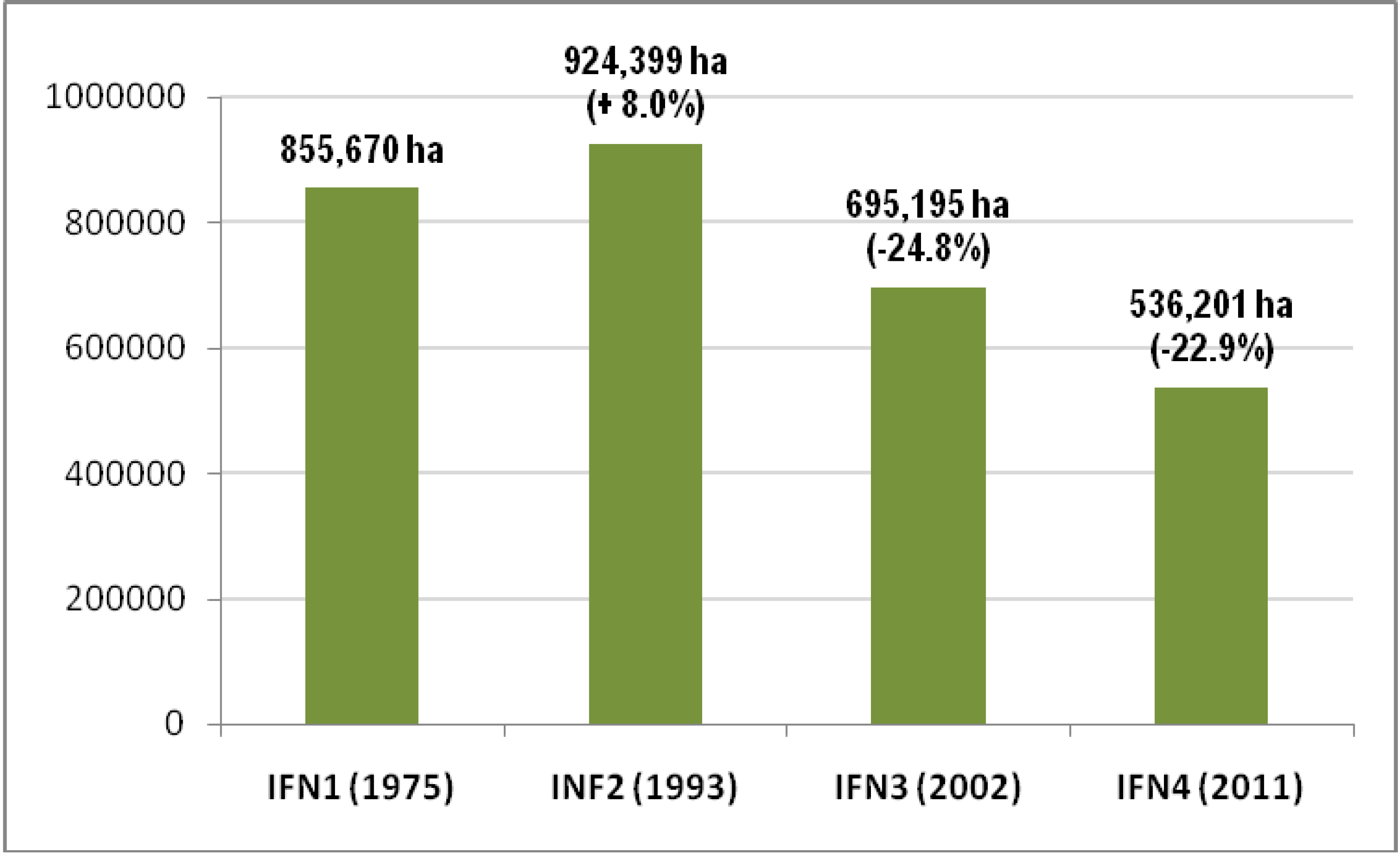
- ICONA, Primer Inventario Forestal de España. Avance de Resultados; (In Spanish). Publicaciones del Ministerio de Agricultura: Madrid, Spain, 1975.
- ICONA, Segundo Inventario Forestal Nacional. 1986–1995. Galicia. La Coruña; (In Spanish). Ministerio de Agricultura, Pesca y Alimentación: Madrid, Spain, 1993.
- ICONA, Segundo Inventario Forestal Nacional. 1986–1995. Galicia. Lugo; (In Spanish). Ministerio de Agricultura, Pesca y Alimentación: Madrid, Spain, 1993.
- ICONA, Segundo Inventario Forestal Nacional. 1986–1995. Galicia. Orense; (In Spanish). Ministerio de Agricultura, Pesca y Alimentación: Madrid, Spain, 1993.
- ICONA, Segundo Inventario Forestal Nacional. 1986–1995. Galicia. Pontevedra; (In Spanish). Ministerio de Agricultura, Pesca y Alimentación: Madrid, Spain, 1993.
- Ministerio de Medio Ambiente, Tercer Inventario Forestal Nacional. 1997–2006. Galicia. A Coruña; (In Spanish). Dirección General de Conservación de la Naturaleza: Madrid, Spain, 2001.
- Ministerio de Medio Ambiente, Tercer Inventario Forestal Nacional. 1997–2006. Galicia. Lugo; (In Spanish). Dirección General de Conservación de la Naturaleza: Madrid, Spain, 2002.
- Ministerio de Medio Ambiente, Tercer Inventario Forestal Nacional. 1997–2006. Galicia. Ourense; (In Spanish). Dirección General de Conservación de la Naturaleza: Madrid, Spain, 2002.
- Ministerio de Medio Ambiente, Tercer Inventario Forestal Nacional. 1997–2006. Galicia. Pontevedra; (In Spanish). Dirección General de Conservación de la Naturaleza: Madrid, Spain, 2002.
- Ministerio de Medio Ambiente, y Medio Rural y Marino, Cuarto Inventario Forestal Nacional. Galicia; (In Spanish). Dirección General de Medio Natural y Política Forestal: Madrid, Spain, 2011.
- Fahrig, L. Relative effects of habitat loss and fragmentation on population extinction. J. Wildlife Manage. 1997, 61, 603–610. [Google Scholar] [CrossRef]
- Parker, M.; Mac Nally, R. Habitat loss and the habitat fragmentation threshold: An experimental evaluation of impacts on richness and total abundances using grassland invertebrates. Biol. Conserv. 2002, 105, 217–229. [Google Scholar] [CrossRef]
- Teixido, A.L.; Quintanilla, L.G.; Carreño, F.; Gutiérrez, D. Impacts of changes in land use and fragmentation patterns on Atlantic coastal forests in northern Spain. J. Environ. Manage. 2010, 91, 897–886. [Google Scholar] [CrossRef]
- Schumaker, N.H. Using landscape indices to predict habitat connectivity. Ecology 1996, 77, 1210–1225. [Google Scholar] [CrossRef]
- Canut, J.; García, D.; Obeso, J.R.; Parellada, X. Urogallo Cantábrico (Tetrao Urogallus Cantabricus). In Atlas de las aves Reproductoras de España; (In Spanish). Martí, R., del Moral, J.C., Eds.; Ministerio de Medio Ambiente: Madrid, Spain, 2003; pp. 210–211. [Google Scholar]
- CREN Limousin, Plan d’actions Landes & Tourbières. Rapport d’activité 2006; (In French). Conservatoire Régional des Espaces Naturels du Limousin: Le Theil, France, 2007.
- Lebrun, J. Appui scientifique et technique pour la restauration de la trame écologique “Réseau lands” dans le PNR Oise-Pays de France: Plan d’actions 2010–2015; (In French). Conservatoire d’Espaces naturels de Picardie/PNR Oise Pays-de-France: Amiens, France, 2010. [Google Scholar]
- De Graaf, M.C.C.; Verbeek, P.J.M.; Bobbink, R.; Roelofs, J.G.M. Restoration of species-rich dry heaths: The importance of appropriate soil conditions. Acta Bot. Neerl. 1998, 47, 89–113. [Google Scholar]
- Decleer, K. Ecological Restoration in Flanders; Mededelingen van het Instituut voor Natuur- en Bosonderzoek (INBO): Anderlecht, Belgium, 2008. [Google Scholar]
- Spencer, D. Tees Valley Lowland Heathland Habitat Action Plan 2009–2013; Redcar & Cleveland Borough Council: Redcar, UK, 2009. [Google Scholar]
- JNCC, Biodiversity: The UK Steering Group Report. Action Plans (Annex F and Annex G); Joint Nature Conservation Committee: London, UK, 1995; Volume 2.
- Irving, J.A. Warwickshire, Coventry and Solihull Local Biodiversity Action Plan. Lowland Heathland; Warwickshire County Council: Warwick, UK, 2002. [Google Scholar]
- Gimingham, C.H. The effects of grazing on the balance between erica cinerea L. and calluna vulgaris (L.) hull. In upland heath, and their morphological responses. J. Ecol. 1949, 37, 100–119. [Google Scholar] [CrossRef]
- Farrell, L. Heathland Management; Joint Nature Conservation Committee: Peterborough, UK, 1983. [Google Scholar]
- McKee, A.M. The Effects of Different Grazing Pressures on Vegetation in the Connemra Uplands. B.Sc. Thesis, University College, Galway, Ireland, 1995. [Google Scholar]
- Bullock, J.M.; Pakeman, R.J. Grazing of lowland heath in England: Management methods and their effects on heathland vegetation. Biol. Conserv. 1997, 79, 1–13. [Google Scholar] [CrossRef]
- Webb, N.R. The traditional management of European heathlands. J. Appl. Ecol. 1998, 35, 987–990. [Google Scholar] [CrossRef]
- Sedláková, I.; Chytrý, M. Regeneration patterns in a Central European dry heathland: Effects of burning, sod-cutting and cutting. Plant Ecol. 1999, 143, 77–87. [Google Scholar] [CrossRef]
- Drechsler, M.; Eppink, F.V.; Wätzold, F. Does proactive biodiversity conservation save costs? Biodivers. Conserv. 2011, 20, 1045–1055. [Google Scholar] [CrossRef]
© 2013 by the authors; licensee MDPI, Basel, Switzerland. This article is an open access article distributed under the terms and conditions of the Creative Commons Attribution license (http://creativecommons.org/licenses/by/3.0/).
Share and Cite
Ramil Rego, P.; Rodríguez Guitián, M.A.; López Castro, H.; Ferreiro da Costa, J.; Muñoz Sobrino, C. Loss of European Dry Heaths in NW Spain: A Case Study. Diversity 2013, 5, 557-580. https://doi.org/10.3390/d5030557
Ramil Rego P, Rodríguez Guitián MA, López Castro H, Ferreiro da Costa J, Muñoz Sobrino C. Loss of European Dry Heaths in NW Spain: A Case Study. Diversity. 2013; 5(3):557-580. https://doi.org/10.3390/d5030557
Chicago/Turabian StyleRamil Rego, Pablo, Manuel A. Rodríguez Guitián, Hugo López Castro, Javier Ferreiro da Costa, and Castor Muñoz Sobrino. 2013. "Loss of European Dry Heaths in NW Spain: A Case Study" Diversity 5, no. 3: 557-580. https://doi.org/10.3390/d5030557