Erosion and Sediment Transport Modelling in Shallow Waters: A Review on Approaches, Models and Applications


Abstract
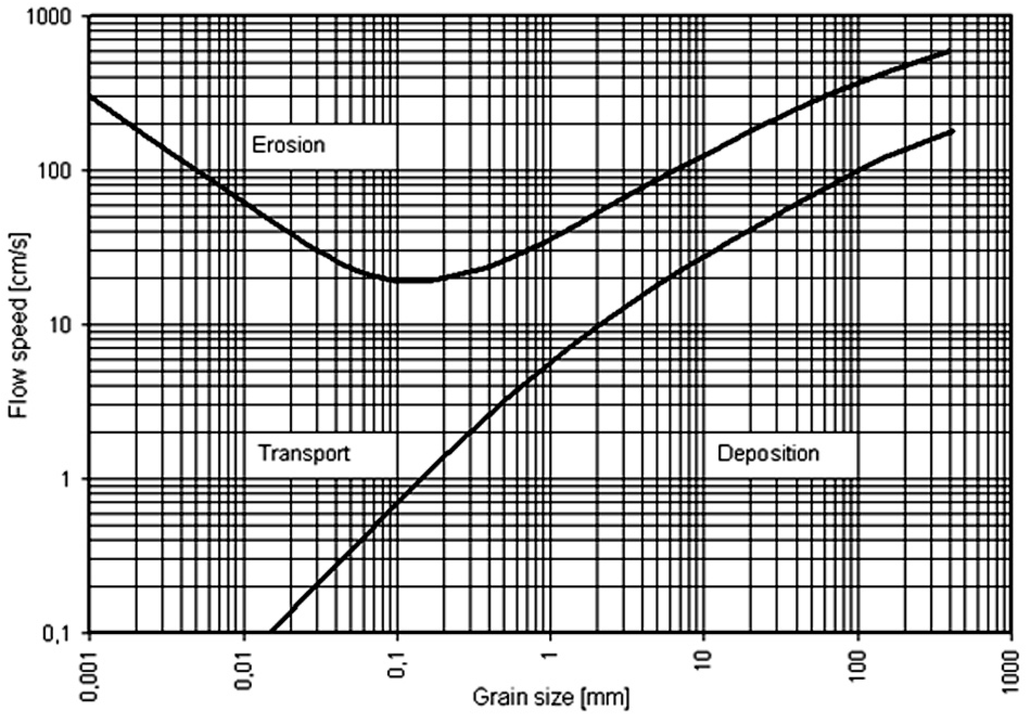
:1. Introduction
2. Soil Erosion and Sediment Transport Models
- (1)
- Empirical models,
- (2)
- Conceptual models,
- (3)
- Physically-based models,
- (4)
- Hybrid models.
- Dataset requirements of the model,
- Fundamental assumptions of the model,
- The accuracy and validity of the model,
- Model capabilities and susceptibilities,
- The components of the model,
- User-friendliness of the model,
- The objectives of the model,
- The scales of the model outputs,
- Hardware requirements of the model.
2.1. Empirical Models
2.2. Conceptual Models
3. Physically-Based Models
Hybrid Models
4. Criteria for the Selection of a Proper Model for Study
5. Conclusions
Acknowledgments
Author Contributions
Conflicts of Interest
References
- Committee, A.T. Sediment sources and sediment yields. Am. Soc. Civil Eng. Hydraul. Div. J. 1970, 7337, 1283–1329. [Google Scholar]
- Kuznetsov, M.S.; Gendugov, V.M.; Khalilov, M.S.; Ivanuta, A.A. An equation of soil detachment by flow. Soil Tillage Res. 1998, 46, 97–102. [Google Scholar] [CrossRef]
- Wei, H.; Nearing, M.A.; Stone, J.J.; Guertin, D.P.; Spaeth, K.E.; Pierson, F.B.; Nichols, M.H.; Moffet, C.A. A New Splash and Sheet Erosion Equation for Rangelands. Soil Sci. Soc. Am. J. 2009, 73, 1386–1392. [Google Scholar] [CrossRef]
- Moss, A.J.; Walker, P.H.; Hutka, J. Raindrop-stimulated transportation in shallow water flows: An experimental study. Sediment. Geol. 1979, 22, 165–184. [Google Scholar] [CrossRef]
- Pierson, F.B.; Moffet, C.A.; Williams, C.J.; Hardegree, S.P.; Clark, P.E. Prescribed-fire effects on rill and interrill runoff and erosion in a mountainous sagebrush landscape. Earth Surf. Process. Landf. 2009, 34, 193–203. [Google Scholar] [CrossRef]
- Knapen, A.; Poesen, J.; Govers, G.; Gyssels, G.; Nachtergaele, J. Resistance of soils to concentrated flow erosion: A review. Earth-Sci. Rev. 2007, 80, 75–109. [Google Scholar] [CrossRef]
- Hairsine, P.B.; Rose, C.W. Modeling water erosion due to overland flow using physical principles: 1. Sheet flow. Water Resour. Res. 1992, 28, 237–243. [Google Scholar] [CrossRef]
- Engelund, F.; Hansen, E. A Monograph on Sediment Transport in Alluvial Streams; TU Delf: Delf, The Netherlands, 1967. [Google Scholar]
- Merritt, W.S.; Letcher, R.A.; Jakeman, A.J. A review of erosion and sediment transport models. Environ. Model. Softw. 2003, 18, 761–799. [Google Scholar] [CrossRef]
- Guy, B.T.; Dickenson, W.T.; Sohrabi, T.M.; Rudra, R.P. Development of an empirical model for calculating sediment-transport capacity in shallow overland flows: Model calibration. Biosyst. Eng. 2009, 103, 245–255. [Google Scholar] [CrossRef]
- Jayawardena, A.W.; Bhuiyan, R.R. Evaluation of an interrill soil erosion model using laboratory catchment data. Hydrol. Process. 1999, 13, 89–100. [Google Scholar] [CrossRef]
- Al-Hamdan, O.Z.; Pierson, F.B.; Nearing, M.A.; Stone, J.J.; Williams, C.J.; Moffet, C.A.; Kormos, P.R.; Boll, J.; Weltz, M.A. Characteristics of concentrated flow hydraulics for rangeland ecosystems: Implications for hydrologic modeling. Earth Surf. Process. Landf. 2012, 37, 157–168. [Google Scholar] [CrossRef]
- Flanagan, D.C.; Nearing, M.A. USDA—Water Erosion Prediction Project Hillslope Profile and Watershed Model Documentation; USDA: Washington, DC, USA, 1995.
- Foster, G.R. Modeling the erosion process. In Hydrol. Model. Small Watersheds; American Society of Agricultural Engineers: Washington, DC, USA, 1982; pp. 97–380. [Google Scholar]
- Hjulstrom, F. Studies of the Morphological Activity of Rivers as Illustrated by the River Fyris. Ph.D. Thesis, Uppsala Universitet, Uppsala, Sweden, 1935. [Google Scholar]
- Proffitt, A.P.B.; Rose, C.W.; Hairsine, P.B. Rainfall Detachment and Deposition: Experiments with Low Slopes and Significant Water Depths. Soil Sci. Soc. Am. J. 1991, 55, 325–332. [Google Scholar] [CrossRef]
- Van Dijk, A.I.J.M.; Brakenridge, G.R.; Kettner, A.J.; Beck, H.E.; de Groeve, T.; Schellekens, J. River gauging at global scale using optical and passive microwave remote sensing. Water Resour. Res. 2016, 52, 6404–6418. [Google Scholar] [CrossRef]
- Recanatesi, F.; Petroselli, A.; Ripa, M.; Leone, A.L.-J. Assessment of stormwater runoff management practices and BMPs under soil sealing: A study case in a peri-urban watershed of the metropolitan area of Rome (Italy). J. Environ. Manag. 2017, 201, 6–18. [Google Scholar] [CrossRef] [PubMed]
- Burns, I.S.; Scott, S.; Levick, L.; Hernandez, M.; Goodrich, D.C.; Miller, S.N.; Semmens, D.J.; Kepner, W.G. Automated Geospatial Watershed Assessment (AGWA)-A GIS-Based Hydrologic Modeling Tool. 2004. Available online: http://www.tucson.ars.ag.gov/agwa/ (accessed on 14 March 2018).
- Mitasova, H.; Hofierka, J.; Zlocha, M.; Iverson, L.R. Modelling topographic potential for erosion and deposition using GIS. Int. J. Geogr. Inf. Syst. 1996, 10, 629–641. [Google Scholar] [CrossRef]
- Bolognesi, M.; Farina, G.; Alvisi, S.; Franchini, M.; Pellegrinelli, A.; Russo, P. Measurement of surface velocity in open channels using a lightweight remotely piloted aircraft system. Geomat. Nat. Hazards Risk 2017, 8, 73–86. [Google Scholar] [CrossRef]
- Kinnell, P.I.A. Simulations demonstrating interaction between coarse and fine sediment loads in rain-impacted flow. Earth Surf. Process. Landf. 2006, 31, 355–367. [Google Scholar] [CrossRef]
- Kinnell, P.I.A. Raindrop-impact-induced erosion processes and prediction: A review. Hydrol. Process. 2005, 19, 2815–2844. [Google Scholar] [CrossRef]
- Jakeman, A.J.; Littlewood, I.G.; Whitehead, P.G. Computation of the instantaneous unit hydrograph and identifiable component flows with application to two small upland catchments. J. Hydrol. 1990, 117, 275–300. [Google Scholar] [CrossRef]
- Prosser, I.P.; Young, B.; Rustomji, P.; Hughes, A.; Moran, C. A model of river sediment budgets as an element of river health assessment. In Proceedings of the International Congress on Modelling and Simulation (MODSIM’2001), Canberra, Australia, 10–13 December 2001; pp. 10–13. [Google Scholar]
- Jakeman, A.J.; Green, T.R.; Beavis, S.G.; Zhang, L.; Dietrich, C.R.; Crapper, P.F. Modelling upland and instream erosion, sediment and phosphorus transport in a large catchment. Hydrol. Process. 1999, 13, 745–752. [Google Scholar] [CrossRef]
- Appelboom, T.W.; Chescheir, G.M.; Skaggs, R.W.; Hesterberg, D.L. Management practices for sediment reduction from forest roads in the coastal plains. Trans. ASAE 2002, 45, 337–344. [Google Scholar] [CrossRef]
- Atwell, B.H.; MacDonald, R.B.; Bartolucci, L.A. Thermal Mapping of Streams from Airborne Radiometric Scanning; Wiley Online Library: Hoboken, NJ, USA, 1971. [Google Scholar]
- Bonell, M. Progress in the understanding of runoff generation dynamics in forests. J. Hydrol. 1993, 150, 217–275. [Google Scholar] [CrossRef]
- Bonell, M.; Gilmour, D.A. The development of overland flow in a tropical rainforest catchment. J. Hydrol. 1978, 39, 365–382. [Google Scholar] [CrossRef]
- Dunne, T.; Leopold, L.B. Water in Environmental Planning; Macmillan: London, UK, 1978. [Google Scholar]
- Huang, J.; Lacey, S.T.; Ryan, P.J. Impact of Forest Harvesting on the Hydraulic Properties of Surface Soil. Soil Sci. 1996, 161, 79–86. [Google Scholar] [CrossRef]
- Incerti, M.; Clinnick, P.F.; Willatt, S.T. Changes in the physical properties of a forest soil following logging. Aust. For. Res. 1987, 17, 91–98. [Google Scholar]
- Johnson, M.G.; Beschta, R.L. Logging, infiltration capacity, and surface erodibility in western Oregon. J. For. 1980, 78, 334–337. [Google Scholar]
- Ketcheson, G.L.; Megahan, W.F.; King, J.G. “R1–R4” and “BOISED” sediment prediction model tests using forest roads in granitics. J. Am. Water Resour. Assoc. 1999, 35, 83–98. [Google Scholar] [CrossRef]
- Lisle, T.E. Sediment transport and resulting deposition in spawning gravels, north coastal California. Water Resour. Res. 1989, 25, 1303–1319. [Google Scholar] [CrossRef]
- Ziegler, A.D.; Sutherland, R.A.; Giambelluca, T.W. Interstorm surface preparation and sediment detachment by vehicle traffic on unpaved mountain roads. Earth Surf. Process. Landf. 2001, 26, 235–250. [Google Scholar] [CrossRef]
- Coe, D.B.R. Sediment Production and Delivery from Forest Roads in the Sierra Nevada, California; Colorado State University: Fort Collins, CO, USA, 2006. [Google Scholar]
- MacDonald, L.H.; Coe, D.; Litschert, S. Assessing Cumulative Watershed Effects in the Central Sierra Nevada: Hillslope Measurements and Catchment-Scale Modeling; USDA: Washington, DC, USA, 2004.
- Stafford, A.K. Sediment Production and Delivery from Hillslopes and Forest Roads in the Southern Sierra Nevada, California. Master’s Thesis, Colorado State University, Fort Collins, CO, USA, 2011. [Google Scholar]
- Wheater, H.S.; Jakeman, A.J.; Beven, K.J. Progress and Directions in Rainfall-Runoff Modelling; FAO: Rome, Italy, 1993. [Google Scholar]
- Morgan, M. The World in the Model: How Economists Work and Think; Cambridge University Press: Cambridge, UK, 2012. [Google Scholar]
- Campbell, F.B.; Bauder, H.A. A rating-curve method for determining silt-discharge of streams. Eos Trans. Am. Geophys. Union 1940, 21, 603–607. [Google Scholar] [CrossRef]
- Musgrave, G.W. The quantitative evaluation of factors in water erosion, a first approximation. J. Soil Water Conserv. 1947, 2, 133–138. [Google Scholar]
- Dendy, F.E.; Bolton, G.C. Sediment yield-runoff-drainage area relationships in the United States. J. Soil Water Conserv. 1976, 31, 264–266. [Google Scholar]
- Flaxman, E.M. Predicting Sediment Yield in Western-United-States. Am. Soc. Civ. Eng. 1974, 100, 693–695. [Google Scholar]
- Renfro, G.W. Use of erosion equations and sediment delivery ratios for predicting sediment yield. In Present and Prospective Technology for Predicting Sediment Yields and Sources; U.S. Department of Agriculture, Agricultural Research Service: Washington, DC, USA, 1975; pp. 33–45. [Google Scholar]
- Rendon-Herrero, O. Estimation of washload produced on certain small watersheds. J. Hydraul. Div. 1974, 100, 835–848. [Google Scholar]
- Singh, V.P.; Baniukiwicz, A.; Chen, V.J. An Instantaneous Unit Sediment Graph Study for Small Upland Watersheds. In Applied Modeling in Catchment Hydrology; Water Resources Publications: Madison, WI, USA, 1982; pp. 534–554. [Google Scholar]
- PSIAC Report—“Factors Affecting Sediment Yield and Measures for the Reduction of Erosion and Sediment Yield”. Available online: http://allaboutwatersheds.org/library/PSIAC%20report.pdf/view (accessed on 31 October 1968).
- Williams, J.R.; Berndt, H.D. Sediment Yield Prediction Based on Watershed Hydrology. Trans. Am. Soc. Agric. Eng. 1977, 20, 1100–1104. [Google Scholar] [CrossRef]
- Wischmeier, W.H.; Smith, D.D. Predicting rainfall erosion losses—A guide to conservation planning. In Predicting Rainfall Erosion Losses—A Guide to Conservation Planning; Department of Agriculture: Washington, DC, USA, 1978; pp. 537–539. [Google Scholar]
- Stocking, M. A Working Model for the Estimation of Soil Loss Suitable for Underdeveloped Areas; School of Development Studies, University of East Anglia: Norwich, UK, 1981. [Google Scholar]
- Renard, K.G.; Foster, G.R.; Weesies, G.A.; Porter, J.P. RUSLE: Revised universal soil loss equation. J. Soil Water Conserv. 1991, 46, 30–33. [Google Scholar]
- Renard, K.G.; Foster, G.R.; Yoder, D.C.; McCool, D.K. RUSLE revisited: Status, questions, answers, and the future. J. Soil Water Conserv. 1994, 49, 213–220. [Google Scholar]
- Nearing, M.A.; Simanton, J.R.; Norton, L.D.; Bulygin, S.J.; Stone, J. Soil erosion by surface water flow on a stony, semiarid hillslope. Earth Surf. Process. Landf. 1999, 24, 677–686. [Google Scholar] [CrossRef]
- Ferro, V.; Porto, P. Sediment Delivery Distributed (SEDD) Model. J. Hydrol. Eng. 2000, 5, 411–422. [Google Scholar] [CrossRef]
- Takken, I.; Jetten, V.; Govers, G.; Nachtergaele, J.; Steegen, A. The effect of tillage-induced roughness on runoff and erosion patterns. Geomorphology 2001, 37, 1–14. [Google Scholar] [CrossRef]
- Meyer, C.R.; Flanagan, D.C.; Fu, H.L.; Lown, J.B.; Wagner, L.E.; Gu, Y.W. MOSES, a common graphical user interface for multiple erosion models. In Proceedings of the ASA Annual Meeting, Anaheim, CA, USA, 21 April 1997. [Google Scholar]
- Meyer, C.R.; Wagner, L.E.; Yoder, D.C.; Flanagan, D.C. The modular soil erosion system (MOSES). In Soil Erosion; American Society of Agricultural and Biological Engineers: St. Joseph, MI, USA, 2001; p. 358. [Google Scholar]
- Copeland, C. Clean Water Act and Total Maximum Daily Loads (TMLDs) of Pollutants; Congressional Research Service CRS: Washington, DC, USA, 2003.
- Syvitski, J.P.M.; Milliman, J.D. Geology, Geography, and Humans Battle for Dominance over the Delivery of Fluvial Sediment to the Coastal Ocean. J. Geol. 2007, 115, 1–19. [Google Scholar] [CrossRef]
- Beck, M.B. Water quality modeling: A review of the analysis of uncertainty. Water Resour. Res. 1987, 23, 1393–1442. [Google Scholar] [CrossRef]
- Lal, R. Soil Erosion Research Methods; CRC Press: Boca Raton, FL, USA, 1994. [Google Scholar]
- Sorooshian, S. Parameter estimation, model identification, and model validation: Conceptual-type models. In Recent Advances in the Modeling of Hydrologic Systems; Springer: Berlin/Heidelberg, Germany, 1991; pp. 443–467. [Google Scholar]
- Abbott, M.B.; Bathurst, J.C.; Cunge, J.A.; O’Connell, P.E.; Rasmussen, J. An introduction to the European Hydrological System—Systeme Hydrologique Europeen ‘SHE’ 1: History and philosophy of a physically-based, distributed modelling system. J. Hydrol. 1986, 87, 45–59. [Google Scholar] [CrossRef]
- Jakeman, A.J.; Hornberger, G.M. How much complexity is warranted in a rainfall-runoff model? Water Resour. Res. 1993, 29, 2637–2649. [Google Scholar] [CrossRef]
- Kleissen, F.M.; Beck, M.B.; Wheater, H.S. The identifiability of conceptual hydrochemical models. Water Resour. Res. 1990, 26, 2979–2992. [Google Scholar] [CrossRef]
- Johnson, J. Distribution graphs of suspended-matter concentration. Trans. Am. Soc. Civ. Eng. 1943, 108, 941–956. [Google Scholar]
- Renard, K.G.; Laursen, E.M. Dynamic behavior model of ephemeral stream. J. Hydraul. Div. 1975, 101, 511–528. [Google Scholar]
- Rendon-Herrero, O. Unit sediment graph. Water Resour. Res. 1978, 14, 889–901. [Google Scholar] [CrossRef]
- Williams, J.R. A sediment graph model based on an instantaneous unit sediment graph. Water Resour. Res. 1978, 14, 659–664. [Google Scholar] [CrossRef]
- Williams, J.R.; Hann, R. Optimal Operation of Large Agricultural Watersheds with Water Quality Constraints; Technical Report; Texas A&M University: College Station, TX, USA, 1978. [Google Scholar]
- Sharma, T.C.; Dickinson, W.T. Discrete dynamic model of watershed sediment yield. J. Hydraul. Div. 1979, 105, 555–571. [Google Scholar]
- Singh, V.P.; Quiroga, C.A. A dam-breach erosion model: I. Formulation. Water Resour. Manag. 1987, 1, 177–197. [Google Scholar] [CrossRef]
- Beven, K.J.; Kirkby, M.J. A physically based, variable contributing area model of basin hydrology. Hydrol. Sci. Bull. 1979, 24, 43–69. [Google Scholar] [CrossRef]
- Johanson, R.C.; Davis, H.H. Users Manual for Hydrological Simulation Program-Fortran (HSPF); Environmental Research Laboratory, Office of Research and Development, U.S. Environmental Protection Agency: Washington, DC, USA, 1980; Volume 80.
- Williams, J.R.; Jones, C.A.; Dyke, P.T. The EPIC model and its application. In Proceedings of the International Symposium on Minimum Data Sets for Agrotechnology Transfer, Patancheru, India, 21–26 March 1984; pp. 111–121. [Google Scholar]
- Young, R.A.; Onstad, C.A.; Bosch, D.D.; Anderson, W.P. AGNPS: A nonpoint-source pollution model for evaluating agricultural watersheds. J. Soil Water Conserv. 1989, 44, 168–173. [Google Scholar]
- Arnold, J.G.; Allen, P.M.; Bernhardt, G. A comprehensive surface-groundwater flow model. J. Hydrol. 1993, 142, 47–69. [Google Scholar] [CrossRef]
- Arnold, J.G.; Soil, G. SWAT (Soil and Water Assessment Tool); Grassland, Soil and Water Research Laboratory, USDA, Agricultural Research Service: Washington, DC, USA, 1994.
- USEPA. SWRRBWQ: Window’s Interface User’s Guide; U.S. Environmental Protection Agency: Washington, DC, USA, 1994.
- Schulze, R.E. Hydrology and Agrohydrology: A Text to Accompany the ACRU 3.00 Agrohydrological Modelling System; Water Research Commission: Pretoria, South African, 1995. [Google Scholar]
- McCown, R.L.; Hammer, G.L.; Hargreaves, J.N.G.; Holzworth, D.P.; Freebairn, D.M. APSIM: A novel software system for model development, model testing and simulation in agricultural systems research. Agric. Syst. 1996, 50, 255–271. [Google Scholar] [CrossRef]
- Krysanova, V.; Müller-Wohlfeil, D.-I.; Becker, A. Development and test of a spatially distributed hydrological/water quality model for mesoscale watersheds. Ecol. Model. 1998, 106, 261–289. [Google Scholar] [CrossRef]
- Simons, M.; Podger, G.; Cooke, R. IQQM—A hydrologic modelling tool for water resource and salinity management. Environ. Softw. 1996, 11, 185–192. [Google Scholar] [CrossRef]
- Favis-Mortlock, D.T. An evolutionary approach to the simulation of rill initiation and development. In Proceedings of the First International Conference on Geocomputation, Leeds, UK, 17–19 September 1996; Volume 1, pp. 248–281. [Google Scholar]
- Kirkby, M.L.; McMahon, M.J. MEDRUSH and the Catsop basin—The lessons learned. CATENA 1999, 37, 495–506. [Google Scholar] [CrossRef]
- Viney, N.; Sivapalan, M. A conceptual model of sediment transport: Application to the Avon River Basin in Western Australia. Hydrol. Process. 1999, 13, 727–743. [Google Scholar] [CrossRef]
- Kinnell, P. AGNPS-UM: Applying the USLE-M within the agricultural non point source pollution model. Environ. Model. Softw. 2000, 15, 331–334. [Google Scholar] [CrossRef]
- Vertessy, R.; Watson, F.; Rahman, J. New software to aid water quality management in the catchments and waterways of the south-east Queensland region. In Proceedings of the Third Australian Stream Management Conference: The Value of Healthy Streams, Brisbane, Australia, 27–29 August 2001. [Google Scholar]
- Cerdan, O.; Souchère, V.; Lecomte, V.; Couturier, A. Incorporating soil surface crusting processes in an expert-based runoff model: Sealing and Transfer by Runoff and Erosion related to Agricultural Management. CATENA 2002, 46, 189–205. [Google Scholar] [CrossRef]
- Le Bissonnais, Y.; Montier, C.; Jamagne, M.; Daroussin, J.; King, D. Mapping erosion risk for cultivated soil in France. CATENA 2002, 46, 207–220. [Google Scholar] [CrossRef]
- Coulthard, T.J.; Macklin, M.G.; Kirkby, M.J. A cellular model of Holocene upland river basin and alluvial fan evolution. Earth Surf. Process. Landf. 2002, 27, 269–288. [Google Scholar] [CrossRef]
- Luo, Q. A distributed surface flow model for watersheds with large water bodies and channel loops. J. Hydrol. 2007, 337, 172–186. [Google Scholar] [CrossRef]
- Futter, M.N.; Butterfield, D.; Cosby, B.J.; Dillon, P.J.; Wade, A.J.; Whitehead, P.G. Modeling the mechanisms that control in-stream dissolved organic carbon dynamics in upland and forested catchments. Water Resour. Res. 2007, 43. [Google Scholar] [CrossRef]
- Davison, P.S.; Withers, P.J.A.; Lord, E.I.; Betson, M.J.; Strömqvist, J. PSYCHIC—A process-based model of phosphorus and sediment mobilisation and delivery within agricultural catchments. Part 1: Model description and parameterisation. J. Hydrol. 2008, 350, 290–302. [Google Scholar] [CrossRef]
- Bennett, J.P. Concepts of mathematical modeling of sediment yield. Water Resour. Res. 1974, 10, 485–492. [Google Scholar] [CrossRef]
- Kandel, D.D.; Western, A.W.; Grayson, R.B.; Turral, H.N. Process parameterization and temporal scaling in surface runoff and erosion modelling. Hydrol. Process. 2004, 18, 1423–1446. [Google Scholar] [CrossRef]
- Pandey, A.; Himanshu, S.; Mishra, S.; Catena, V.S. Physically based soil erosion and sediment yield models revisited. CATENA 2016, 147, 595–620. [Google Scholar] [CrossRef]
- Beven, K. Changing ideas in hydrology—The case of physically-based models. J. Hydrol. 1989, 105, 157–172. [Google Scholar] [CrossRef]
- Lane, L.J.; Nichols, M.H.; Paige, G.B. Modeling erosion on hillslopes: Concepts, theory and data. In Proceedings of the International Congress on Modelling and Simulation, Newcastle, UK, 25–27 November 1995; Binning, P., Bridg, H., Williams, B., Eds.; 1995; Volume 1, pp. 1–7. [Google Scholar]
- Seyfried, M.S.; Wilcox, B.P. Scale and the nature of spatial variability: Field examples having implications for hydrologic modeling. Water Resour. Res. 1995, 31, 173–184. [Google Scholar] [CrossRef]
- Dunin, F. Prediction in catchment hydrology. In Proceedings of the National Symposium on Hydrology, Canberra, Australia, 28–31 July 1975. [Google Scholar]
- Beven, K. Spatially distributed modeling: Conceptual approach to runoff prediction. In Recent Advances in the Modeling of Hydrologic Systems; Springer: Berlin/Heidelberg, Germany, 1991; pp. 373–387. [Google Scholar]
- Hjelmfelt, A.T., Jr.; Piest, R.P.; Saxton, K.E. Mathematical modeling of erosion on upland areas. In Fundam. Tools to Be Used Environ. Probl. Proceedings Outil. Fondam. Util Pour Resoudre les Probl. D’environnement Comptes-Rendus; International Association for Hydraulic Research: Congress São Paulo, Brazil, 1975. [Google Scholar]
- Lane, L.J.; Shirley, E.D. Mathematical Simulation of Erosion of Upland Area. Unpubl. Manuscr. Rev. Publ. 1978; unpublished manuscript in review for publication. [Google Scholar]
- Singh, V.P.; Regl, R.R. Analytical solutions of kinematic equations for erosion on a plane I. Rainfall of indefinite duration. Adv. Water Resour. 1983, 6, 2–10. [Google Scholar] [CrossRef]
- Foster, G.R.; Meyer, L.D.; Onstad, C.A. An erosion equation derived from basic erosion principles. Trans. ASAE 1977, 20, 678–682. [Google Scholar] [CrossRef]
- Beasley, D.B.; Huggins, L.F.; Monke, E.J. ANSWERS: A Model for Watershed Planning. Trans. ASAE 1980, 23, 938–944. [Google Scholar] [CrossRef]
- Knisel, W. CREAMS: A Field-Scale Model for Chemicals, Runoff and Erosion from Agricultural Management Systems; USDA: Washington, DC, USA, 1980; p. 640.
- Prasad, S.N.; Singh, V.P. Hydrodynamic Model of Sediment Transport in Rill Flows. In Recent Developments in the Explanation and Prediction of Erosion and Sediment Yield; Walling, D.E., Ed.; International Association of Hydrological Sciences: Wallingford, CT, USA, 1982. [Google Scholar]
- Williams, J.R. Spnm, a Model for Predicting Sediment, Phosphorus, and Nitrogen Yields from Agricultural Basins. JAWRA J. Am. Water Resour. Assoc. 1980, 16, 843–848. [Google Scholar] [CrossRef]
- O’Loughlin, E.M. Prediction of Surface Saturation Zones in Natural Catchments by Topographic Analysis. Water Resour. Res. 1986, 22, 794–804. [Google Scholar] [CrossRef]
- Abbott, M.B.; Bathurst, J.C.; Cunge, J.A.; O’connell, P.E.; Rasmussen, J. An introduction to the European Hydrological System—Systeme Hydrologique Europeen, ‘SHE’, 2: Structure of a physically-based, distributed modelling system. J. Hydrol. 1986, 87, 61–77. [Google Scholar] [CrossRef]
- Lopez-Garcia, M.J.; Caselles, V. Use of Thematic Mapper data to assess water quality in Albufera Lagoon of Valencia (Spain). In Advances in Digital Image Processing; Remote Sensing Society: Nottingham, UK, 1987; pp. 510–519. [Google Scholar]
- Storm, B.; Jorgensen, G.H. Simulation of water flow and soil erosion processes with a distributed physically-based modelling system. In Forest Hydrology and Watershed Management; Swanson, R.H., Bernier, P.Y., Woodard, P.D., Eds.; International Association of Hydrological Sciences: Wallingford, CT, USA, 1987. [Google Scholar]
- Wicks, J.M. Physically-Based Mathematical Modelling of Catchment Sediment Yield; Newcastle University: Newcastle, UK, 1988. [Google Scholar]
- Riggins, R.E.; Ward, T.J.; Hodge, W. Volume II: Program documentation. In ARMSED, a Runoff and Sediment Yield Model for Army Training Land Watershed Management; FAO: Rome, Italy, 1989. [Google Scholar]
- Borah, D.K.D.K. Runoff Simulation Model for Small Watersheds. Trans. ASAE 1989, 32, 881–886. [Google Scholar] [CrossRef]
- Woolhiser, D.; Smith, R.-E.; Goodrich, D.-C. KINEROS, a Kinematic Runoff and Erosion Model: Documentation and User Manual; U.S. Department of Agriculture, Agricultural Research Service: Washington, DC, USA, 1990; p. 130.
- Laflen, J.M.; Lane, L.J.; Foster, G.R. WEPP: A new generation of erosion prediction technology. J. Soil Water Conserv. 1991, 46, 34–38. [Google Scholar]
- Littleboy, M.; Silburn, D.M.; Freebairn, D.M.; Woodruff, D.R.; Hammer, G.L.; Leslie, J.K. Impact of soil erosion on production in cropping systems. I. Development and validation of a simulation model. Soil Res. 1992, 30, 757–774. [Google Scholar] [CrossRef]
- Smith, R.E. Volume 1, documentation. Research report. In OPUS: An Integrated Simulation Model for Transport of Nonpoint-Source Pollutants at the Field Scale; Western Utilization Research and Development Div.: Albany, CA, USA, 1992. [Google Scholar]
- Knisel, W.G.; Davis, F.M. GLEAMS Version 3.0 User Manual; Report SEWRL-WGK/FMD-050199; USDA-ARS-SEWRL: Tifton, GA, USA, 1999. [Google Scholar]
- Schramm, M. Ein Erosionsmodell Mit Zeitlich und Raumlich Veranderlicher Rillengeometrie; Mitteilungen No. 190 Inst. f. Wasserbau u. Kulturtechnik; Universität Karlsruhe: Karlsruhe, Germany, 1994. [Google Scholar]
- Kirkby, M.J.; Cox, N.J. A climatic index for soil erosion potential (CSEP) including seasonal and vegetation factors. CATENA 1995, 25, 333–352. [Google Scholar] [CrossRef]
- Von Werner, M. GIS-Orientierte Methoden der Digitalen Reliefanalyse zur Modellierung von Bodenerosion in kleinen Einzugsgebieten. Ph.D. Thesis, Freie Universität, Berlin, Germany, 1995. [Google Scholar]
- De Roo, A.P.J.; Wesseling, C.G.; Ritsema, C.J. Lisem: A Single-Event Physically Based Hydrological and Soil Erosion Model for Drainage Basins. I: Theory, Input and Output. Hydrol. Process. 1996, 10, 1107–1117. [Google Scholar] [CrossRef]
- Bathurst, J.C.; Kilsby, C.; White, S.; Brandt, C.J.; Thornes, J.B. Modelling the Impacts of Climate and Land-Use Change on Basin Hydrology and Soil Erosion in Mediterranean Europe. In Mediterranean Desertification and Land Use; John Wiley & Sons Ltd.: Chichester, UK, 1996; pp. 355–387. [Google Scholar]
- Rose, C.W.; Coughlan, K.J.; Ciesiolka, C.A.A.; Fentie, B. Program GUEST (Griffith University Erosion System Template). In A New Soil Conservation Methodology and Application to Cropping Systems in Tropical Steeplands; ACIAR Technical Report; Coughlan, K.J., Rose, C.W., Eds.; ACIAR: Canberra, Australia, 1997; pp. 34–38. [Google Scholar]
- Mitas, L.; Mitasova, H. Distributed soil erosion simulation for effective erosion prevention. Water Resour. Res. 1998, 34, 505–516. [Google Scholar] [CrossRef]
- Morgan, R.P.C.; Quinton, J.N.; Smith, R.E.; Govers, G.; Poesen, J.W.A.; Chisci, G.; Torri, D. The EUROSEM Model. In Modelling Soil Erosion by Water; Springer: Berlin/Heidelberg, Germany, 1998; pp. 389–398. [Google Scholar]
- Torri, D.; Morgan, R.P.C. Modelling within-storm soil erosion dynamics. Presented at European Climate Science Conference, Vienna, Austria, 19–23 October 1998. [Google Scholar]
- Hanley, N.; Faichney, R.; Munro, A.; Shortle, J.S. Economic and environmental modelling for pollution control in an estuary. J. Environ. Manag. 1998, 52, 211–225. [Google Scholar] [CrossRef]
- Woodward, D.E. Method to predict cropland ephemeral gully erosion. CATENA 1999, 37, 393–399. [Google Scholar] [CrossRef]
- De Jong, S.M.; Paracchini, M.L.; Bertolo, F.; Folving, S.; Megier, J.; de Roo, A.P.J. Regional assessment of soil erosion using the distributed model SEMMED and remotely sensed data. CATENA 1999, 37, 291–308. [Google Scholar] [CrossRef]
- Johnson, B.E.; Julien, P.Y.; Molnar, D.K.; Watson, C.C. The Two-Dimensional Upland EROSION Model CASC2D-SED1. JAWRA J. Am. Water Resour. Assoc. 2000, 36, 31–42. [Google Scholar] [CrossRef]
- Van Oost, K.; Govers, G.; Desmet, P. Evaluating the effects of changes in landscape structure on soil erosion by water and tillage. Landsc. Ecol. 2000, 15, 577–589. [Google Scholar] [CrossRef]
- Kirkby, M.J.; le Bissonais, Y.; Coulthard, T.J.; Daroussin, J.; McMahon, M.D. The development of land quality indicators for soil degradation by water erosion. Agric. Ecosyst. Environ. 2000, 81, 125–136. [Google Scholar] [CrossRef]
- Tucker, G.E.; Lancaster, S.; Gasparini, N.; Bras, R. The Channel-Hillslope Integrated Landscape Development Model (CHILD). In Landscape Erosion and Evolution Modeling; Springer: Berlin/Heidelberg, Germany, 2001; pp. 349–388. [Google Scholar]
- Torri, D.; Borselli, L.; Poesen, J.; Nachtergaele, J.; Morgan, R.; Quinton, J.; Albaladejo, J.; Castillo, V.; Mena, M.; Sardo, V.; et al. Modelling within storm soil erosion dynamics (MWISED). ESSC Newslett. 2002, 1, 4–8. [Google Scholar]
- Goodrich, D.C.; Unkrich, C.L.; Smith, R.E.; Woolhiser, D.A. KINEROS2—A distributed kinematic runoff and erosion model. In Proceedings of the Hydrologic Modeling for the 21st Century, Second Federal Interagency Hydrologic Modeling Conference, Las Vegas, NV, USA, 28 July–1 August 2002. [Google Scholar]
- Downer, C.W.; Ogden, F.L. GSSHA: Model to Simulate Diverse Stream Flow Producing Processes. J. Hydrol. Eng. 2004, 9, 161–174. [Google Scholar] [CrossRef]
- Borah, D.; Bera, M.; Shaw, S.; Keefer, L. Dynamic Modeling and Monitoring of Water, Sediment, Nutrients, and Pesticides in Agricultural Watersheds during Storm Events. Available online: ideals.illinois.edu (accessed on 2 February 2017).
- Gordon, L. REGEM: The Revised Ephemeral Gully Erosion Model. In Proceedings of the Eighth Federal Interagency Sedimentation Conference (8th FISC), Reno, NV, USA, 2–6 April 2006. [Google Scholar]
- White, E.D.; Easton, Z.M.; Fuka, D.R.; Collick, A.S.; Adgo, E.; McCartney, M.; Awulachew, S.B.; Selassie, Y.G.; Steenhuis, T.S. Development and application of a physically based landscape water balance in the SWAT model. Hydrol. Process. 2011, 25, 915–925. [Google Scholar] [CrossRef]
- Morgan, R.P.C.; Morgan, D.D.V.; Finney, H.J. A predictive model for the assessment of soil erosion risk. J. Agric. Eng. Res. 1984, 30, 245–253. [Google Scholar] [CrossRef]
- Thornes, J.B. The ecology of erosion. Geography 1985, 70, 222–235. [Google Scholar]
- XP-SOFTWARE. XP-AQUALM—Technical Descriptio; XP Software: Canberra Australia, 1999. [Google Scholar]
- Jakeman, A.J.; Post, D.A.; Schreider, S.Y.; Ye, W. Modelling Environmental Systems: Partitioning the Water Balance at Different Catchment Scales; Comput. Mech. Inc.: Billerica, MA, USA, 1994; pp. 157–170. [Google Scholar]
- Jakeman, A.J.; Post, D.A.; Beck, M.B. From data and theory to environmental model: The case of rainfall runoff. Environmetrics 1994, 5, 297–314. [Google Scholar] [CrossRef]
- National Land and Water Resources Audit. Australian Agriculture Assessment 2001; NLWRA: Canberra, Australia, 2001.
- Barnes, J.; Pelletier, J. Erosion Mapping of the Bolivian Central Andes Using the Stream Power Law and a Digital Elevation Model; Short www communication, Department of GeoSciences, University of Arizona: Tuscon, AZ, USA, 2001; Volume 85721.
- MIKE BASIN. A Versatile Decision Support Tool for Integrated Water Resources Management Planning [R/OL]; The Danish Hydraulic Institute (DHI): Hørsholm, Denmark, 2003. [Google Scholar]
- Krone, R. Flume Studies of the Transport of Sediment in Estuarial Shoaling Processes; Hydraulic Engineering Laboratory and Sanitary Engineering Research Laboratory, University of California: Berkeley, CA, USA, 1962. [Google Scholar]
- Kalin, L.; Hantush, M.M. Assessment of Two Physically-Based Watershed Models Based on Their Performances of Simulating Water and Sediment Movement. Available online: http://www.tucson.ars.ag.gov (accessed on 15 February 2017).
- Kilinc, M.; Richardson, E.V. Mechanics of Soil Erosion from Overland Flow Generated by Simulated Rainfall. Available online: dspace.library.colostate.edu (accessed on 15 February 2017).
- Bagnold, R.A. An Approach to the Sediment Transport Problem from General Physics; U.S. Geological Survey: Riston, VA, USA, 1966; p. 42.


| Model | Name | Spatial Scale | Temporal Scale | Data Demand | Output | Overland Sediment | In-Stream Sediment | Gully Erosion | Rainfall-Runoff | Sediment-Associated Chemicals | Source | ||||
|---|---|---|---|---|---|---|---|---|---|---|---|---|---|---|---|
| Gen. * | Trans. * | Dep. * | Gen. * | Trans. * | Dep. * | ||||||||||
| PSIAC | Pacific Southwest Interagency Committee Method | Catchment, Field | Annual | High | sediment yield | No | No | No | No | No | No | Yes | Yes | No | [50] |
| MUSLE | Modified Universal Soil Loss Equation | Hillslope | Annual | High | Erosion | Yes | No | No | No | No | No | No | No | No | [51] |
| USLE | Universal Soil Loss Equation | Hillslope | Annual | High | Erosion | Yes | No | No | No | No | No | No | No | No | [52] |
| SLEMSA | Soil Loss Estimation Model for Southern Africa | Catchment | Annual | High | Soil loss, sheet erosion | Yes | No | No | No | No | No | No | No | No | [53] |
| RUSLE | Revised Universal Soil Loss Equation | Hillslope | Annual | High | Erosion | Yes | No | No | No | No | No | No | No | No | [54,55] |
| EPM | Erosion Potential Method | Catchment, Field | Annual | High | Erosion, sediment yield | Yes | No | No | No | No | No | Yes | Yes | No | [56] |
| SEDD | Sediment Delivery Distributed | Hillslope, Catchment | Annual, Event | High | Erosion, sediment yield | Yes | No | No | No | No | No | No | Yes | No | [57] |
| TCRP | Tillage-Controlled Runoff Pattern model | Field | Abstract | Low | Gully formation, runoff | No | No | No | No | No | No | Yes | Yes | No | [58] |
| MOSES | Modular Soil Erosion System project | Hillslope | Annual | High | Erosion, sediment yield, runoff | Yes | No | No | No | No | No | No | Yes | No | [59,60] |
| TMDL | Total Maximum Daily Load | Catchment | Annual | Low | Sediment | No | No | No | No | No | No | No | No | Yes | [61] |
| BQART | Not Found | Global/Regional | Annual | High | Erosion, sediment yield, runoff | Yes | Yes | Yes | Yes | Yes | Yes | No | No | No | [62] |
| Model | Name | Spatial Scale | Temporal Scale | Data Demand | Output | Overland Sediment | In-Stream Sediment | Gully Erosion | Rainfall-Runoff | Sediment-Associated Chemicals | Source | ||||
|---|---|---|---|---|---|---|---|---|---|---|---|---|---|---|---|
| Gen. * | Trans. * | Dep. * | Gen. * | Trans. * | Dep. * | ||||||||||
| TOPMODEL | TOPMODEL | Hillslope | Daily | Medium | Sediment yield, runoff | No | No | No | No | No | No | No | Yes | Yes | [76] |
| HSPF | Hydrologic simulation Program, Fortran | Catchment | Daily | High | Sediment load, runoff, flow rate, nutrient | Yes | Yes | Yes | Yes | Yes | Yes | Yes | Yes | Yes | [77] |
| EPIC | Erosion-Productivity Impact Calculator | Field | Daily | High | Sediment load, nutrient | Yes | Yes | Yes | Yes | No | No | No | No | Yes | [78] |
| AGNPS | Agricultural Non-Point Source pollution model | Catchment | Daily | High | Erosion, sediment yield, runoff, peak rate, pollutants | Yes | No | No | Yes | Yes | Yes | Yes | Yes | Yes | [79] |
| SWAT | Soil and Water Assessment Tool | Regional | Daily | Medium | Erosion, sediment yield, runoff, peak rate, nutrient | Yes | Yes | Yes | Yes | Yes | Yes | No | Yes | Yes | [80,81] |
| SWRRB | Simulator for Water Resources in Rural Basins | Catchment | Daily | High | sediment, streamflow, nutrient and pesticide yields | Yes | No | No | Yes | Yes | Yes | No | Yes | Yes | [82] |
| ACRU | Agricultural Catchment Research Unit | Catchment | Daily | Low | Erosion, sediment yield, runoff, flow rate | Yes | No | No | Yes | No | No | Yes | Yes | Yes | [83] |
| APSIM | Agricultural Production Simulator | Field | Daily | High | Erosion, nutrient | Yes | Yes | Yes | No | No | No | No | Yes | Yes | [84] |
| SWIM | Soil and Water Integrated Model | Regional | Daily | Medium | Sediment load, runoff, nutrient | Yes | No | No | No | No | No | No | Yes | Yes | [85] |
| IQQM | Integrated Water Quality and Quantity Model | Regional | Daily | Medium | Sediment load, suspended sediments, pollutants transport, salt fluxes | Yes | No | No | Yes | No | No | No | Yes | Yes | [86] |
| RillGrow 1 and 2 | RillGrow 1 and 2 | Plot | Abstract | High | Rill formation | Yes | Yes | Yes | No | No | No | Yes | No | No | [87] |
| MEDRUSH | MEdalus Desertification Response Unit SHe | Catchment | Hourly | High | sediment transport, net erosion, runoff, soil moisture profiles | Yes | Yes | Yes | Yes | Yes | Yes | Yes | Yes | Yes | [88] |
| LASCAM | Large Scale Catchment Model | Catchment | Daily | High | Sediment load, runoff, salt fluxes | Yes | Yes | Yes | Yes | No | No | No | No | No | [89] |
| AGNPS-UM | Agricultural Non-Point Source pollution model, modified | Catchment | Daily | High | Suspended sediments, runoff, nutrient | Yes | No | No | Yes | Yes | Yes | Yes | Yes | Yes | [90] |
| EMSS | Environmental Monitoring Support System | Catchment | Daily | Low | Sediment load, runoff, nutrient | No | No | No | Yes | Yes | Yes | Yes | Yes | Yes | [91] |
| SEDNET | European SEDiment NETwork | Catchment | Steady-State | Moderate | Suspended sediment, sediment distribution, overland flow | Yes | No | No | No | No | No | No | Yes | Yes | [25] |
| STREAM | Sealing, Transfer, Runoff, Erosion, Agricultural Modification model | Catchment | Event | High | Erosion, sediment generation and transport | Yes | Yes | Yes | Yes | No | No | No | No | No | [92] |
| SERAE | Soil Erosion Risk Assessment in Europe model | Regional | Annual | Medium | Erosion | Yes | No | No | No | No | No | No | Yes | Yes | [93] |
| CAESAR | Cellular Automaton Evolutionary Slope and River model | Catchment-Regional | Annual | High | Erosion, sediment transport | Yes | Yes | Yes | Yes | Yes | Yes | Yes | Yes | No | [94] |
| WILSIM | Web-based Interactive Landform Simulation Model | Hillslope | Abstract | High | Erosion, sediment transport | Yes | No | No | Yes | No | No | No | No | No | [95] |
| INCA-C | Integrated Catchments Model for Carbon | Catchment | Daily | Daily | Suspended sediments, runoff, Dissolved Organic Carbon (DOC) | Yes | Yes | Yes | Yes | Yes | Yes | No | Yes | Yes | [96] |
| PSYCHIC | Phosphorus and Sediment Yield Characterization in Catchments | Catchment | Daily | High | Sediment load, nutrient | Yes | Yes | Yes | No | No | No | No | Yes | Yes | [97] |
| Model | Name | Spatial Scale | Temporal Scale | Data Demand | Output | Overland Sediment | In-Stream Sediment | Gully Erosion | Rainfall-Runoff | Sediment-Associated Chemicals | Source | ||||
|---|---|---|---|---|---|---|---|---|---|---|---|---|---|---|---|
| Gen. * | Trans. * | Dep. * | Gen. * | Trans. * | Dep. * | ||||||||||
| ANSWERS | Areal Nonpoint Source Watershed Environment Response Simulation | Small Catchment | Event | High | Erosion, sediment yield, runoff, peak rate, nutrients | Yes | Yes | Yes | No | No | No | No | Yes | Yes | [110] |
| CREAMS | Chemicals, Runoff and Erosion from Agricultural Management Systems | Field/ Plot | Monthly | High | Erosion, deposition | Yes | Yes | Yes | No | No | No | Yes | Yes | Yes | [111] |
| SPNM | Sediment–Phosphorus–Nitrogen Model | Hillslope/ Catchment | Event | High | Erosion, sediment yield, runoff, nutrients | No | No | No | Yes | Yes | Yes | No | Yes | Yes | [113] |
| TOPOG | The Terrain Analysis Hydrologic Model | Hillslope/ Catchment | Daily | High | Erosion hazard, water logging, solute transport | Yes | Yes | Yes | No | No | No | No | Yes | Yes | [114] |
| MIKE-SHE | Systeme Hydrologique Europeen (French acronym for “European Hydrologic System”) | Hillslope/ Catchment | Event | High | Erosion and sediment yield | Yes | Yes | Yes | Yes | Yes | Yes | No | Yes | No | [66,115] |
| WESP | Watershed Erosion Prediction Project | Small Catchment | Event | Medium | Erosion, sediment yield, runoff | Yes | Yes | Yes | Yes | Yes | Yes | No | Yes | No | [116] |
| SEM | Soil Erosion and Sediment Transport Model | Catchment | Event | High | Erosion, sediment yield | Yes | Yes | Yes | Yes | Yes | Yes | No | No | No | [117] |
| SHESED | SHE- SEDimentation | Hillslope/ Catchment | Event | High | Erosion, sediment yield, runoff | Yes | Yes | Yes | No | No | No | No | Yes | No | [118] |
| ARMSED | Army Multiple Watershed Storm Water and Sediment Runoff | Small Catchment | Event | High | Erosion, sediment yield, runoff | Yes | Yes | Yes | No | No | No | No | Yes | No | [119] |
| RUNOFF | No acronym | Small Catchment | Event | Low | Erosion, sediment yield, runoff, peak rate | Yes | Yes | Yes | No | No | No | No | Yes | No | [120] |
| KINEROS | Kinematic Runoff and Erosion Model | Hillslope/ Small Catchment | Event | High | Erosion, sediment yield, runoff, peak rate | Yes | Yes | Yes | No | No | No | No | No | No | [121] |
| WEPP | Watershed Erosion Prediction Project | Hillslope/ Catchment | Daily | High | Erosion, sediment yield, runoff | Yes | Yes | Yes | Yes | Yes | Yes | No | Yes | No | [122] |
| PERFECT | Productivity, Erosion and Runoff, Functions to Evaluate Conservation Techniques | Field | Daily | High | Erosion, runoff, crop yield | No | No | No | No | No | No | No | Yes | Yes | [123] |
| OPUS | No acronym | Field/ Small Catchment | Daily | High | Erosion, suspended sediments, runoff, nutrient | Yes | Yes | Yes | No | No | No | No | Yes | Yes | [124] |
| GLEAMS | Groundwater Loading Effects of Agricultural Management Systems | Field | Daily | High | Erosion, sediment yield | Yes | Yes | Yes | No | No | No | No | Yes | Yes | [125] |
| PEPP | Process-oriented Erosion Prediction Program | Hillslope/ small catchment | Event | High | Erosion, deposition and sediment and phosphorous transport | Yes | Yes | Yes | Yes | Yes | Yes | No | Yes | Yes | [126] |
| CSEP | Climatic Index for Soil Erosion Potential | Regional/ Hillslope | Monthly/ Event | High | Sediment yield, runoff | Yes | Yes | Yes | Yes | Yes | Yes | Yes | Yes | No | [127] |
| EROSION-3D | EROSION-3D | Field/ small catchment | Event | High | Sediments dynamics | Yes | Yes | Yes | Yes | Yes | Yes | Yes | No | Yes | [128] |
| HEM | Hillslope Erosion Model | Hillslope | Event | High | Erosion, sediment yield, sediment concentration, runoff | Yes | Yes | Yes | Yes | Yes | Yes | No | Yes | Yes | [102] |
| LISEM | Limburg Soil Erosion Model | Small catchment | Event | High | Sediment yield, runoff | Yes | No | No | Yes | Yes | Yes | No | Yes | Yes | [129] |
| SHETRAN | European Distributed Basin Flow and Transport Modelling System | Plot/ catchment | Event | High | Sediment yield, erosion/ deposition, pollutants transport | Yes | Yes | Yes | Yes | Yes | Yes | No | Yes | Yes | [130] |
| GUEST | Griffiths University Erosion System Template | Plot | Steady State | High | Suspended sediment, runoff | Yes | Yes | Yes | No | No | No | No | Yes | No | [131] |
| SIMWE | SIMulation of Water Erosion | Catchment | Event | High | Erosion, sediment transport and deposition, gully formation | Yes | Yes | Yes | No | No | No | Yes | Yes | No | [132] |
| EUROSEM | European Soil Erosion Model | Catchment | Event | High | Erosion, sediment yield, runoff | Yes | Yes | Yes | No | No | No | No | No | No | [133] |
| EUROWISE | EUROpe WIthin Storm Erosion | Catchment | Event | Medium | Erosion, sediment yield, runoff, gully formation | Yes | No | No | Yes | Yes | Yes | Yes | Yes | No | [134] |
| MIKE-11 | Mike (named partially after the author Michael, Mike Abbott) | Catchment | Daily | High | Sediment yield, runoff | No | No | No | Yes | Yes | Yes | No | Yes | Yes | [135] |
| EGEM | Ephemeral Gully Erosion Model | Field | Event | Medium | Gully formation | No | No | No | No | No | No | Yes | No | No | [136] |
| SEMMED | Soil Erosion Model for Mediterranean Areas | Regional | Annual | Medium | Erosion, deposition and sediment transport | Yes | Yes | Yes | No | No | No | Yes | Yes | No | [137] |
| CASC2D-SED | CASCade 2-Dimentional SEDimentation | Catchment | Event | High | Sediment yield, erosion/ deposition | Yes | Yes | Yes | Yes | Yes | Yes | No | Yes | No | [138] |
| WATEM | Water and Tillage Erosion Model | Field | Abstract | Low | Erosion, deposition and sediment transport | Yes | Yes | Yes | Yes | Yes | Yes | No | No | No | [139] |
| PESERA | Pan-European Soil Erosion Risk Assessment model | Regional | Annual | Medium | Erosion, runoff | Yes | Yes | Yes | No | No | No | No | Yes | No | [140] |
| CHILD | Channel-Hillslope Integrated Landscape Development | Hillslope/ catchment | Event | High | Erosion, sediment yield, runoff, gully formation | No | No | No | Yes | Yes | Yes | Yes | Yes | No | [141] |
| MWISED | Modelling Within-Storm Sediment Dynamics | Field | Event | High | Erosion, sediment yield, gully formation | No | Yes | No | Yes | Yes | Yes | Yes | No | No | [142] |
| KINEROS2 | Kinematic Runoff and Erosion Model-2 | Catchment | Event | High | Erosion, sediment yield, runoff, peak rate | Yes | Yes | Yes | No | No | No | No | Yes | No | [143] |
| GSSHA | Gridded Surface/ Subsurface Hydrologic Analysis | Catchment | Event | Medium | Overland erosion, sediment transport, detachment, raindrop impact, and deposition | Yes | Yes | Yes | Yes | Yes | Yes | Yes | Yes | No | [144] |
| DWSM | Dynamic Watershed Simulation Model | Hillslope/ catchment | Event | High | erosion, sediment yield, surface and underground runoff, flood agrochemical transport | Yes | Yes | Yes | Yes | Yes | Yes | Yes | No | Yes | [145] |
| REGEM | Revised Ephemeral Gully Erosion Model | Catchment | Event | High | Erosion, sediment yield, runoff, gully formation | Yes | Yes | Yes | Yes | Yes | Yes | Yes | Yes | Yes | [146] |
| SWAT-WB | Soil and Water Assessment Tool-Water Balance | Regional | Daily | Medium | Erosion, sediment yield, runoff, peak rate, nutrient | Yes | Yes | Yes | Yes | Yes | Yes | No | Yes | Yes | [147] |
| Model | Name | Spatial Scale | Temporal Scale | Data Demand | Output | Overland Sediment | In-Stream Sediment | Gully Erosion | Rainfall-Runoff | Sediment-Associated Chemicals | Source | ||||
|---|---|---|---|---|---|---|---|---|---|---|---|---|---|---|---|
| Gen. * | Trans. * | Dep. * | Gen. * | Trans. * | Dep. * | ||||||||||
| MMMF | Modified Morgan, Morgan and Finney | Hillslope | Annual | High | Erosion, sediment yield and distribution, runoff | Yes | Yes | Yes | No | No | No | Yes | Yes | No | [148] |
| THORNES | Thornes model | Hillslope/Catchment | Event | Medium | Erosion, runoff | Yes | Yes | Yes | No | No | No | No | Yes | No | [149] |
| AQUALM | Networked Storm Water Quality Model | Small Catchments | Daily | Medium | Suspended sediments, runoff and pollutant transport | No | No | No | Yes | Yes | No | No | Yes | Yes | [150] |
| USPED | Unit Stream Power-based Erosion Deposition | Hillslope | Annual/Event | Medium | Erosion | Yes | Yes | Yes | No | No | No | No | No | No | [20] |
| IHACRES-WQ | Identification of unit Hydrographs and Component flows from Rainfall, Evaporation and Streamflow-Water Quality | Catchment | Daily | Low | Erosion, sediment yield, runoff, nutrients | no | no | no | Yes | Yes | Yes | Yes | Yes | Yes | [24,151,152] |
| SEDNET | Sediment river network model | Regional/Catchment | Annual | High | Sediment load and distribution, suspended sediments, runoff, nutrients | Yes | Yes | Yes | Yes | Yes | Yes | Yes | Yes | No | [153] |
| SPL | Stream Power Law Model | Catchment | Annual | Medium | Riverine erosion | Yes | No | No | No | No | No | No | No | No | [154] |
| SEAGIS | Erosion Assessment Tool of MIKE BASIN & MILW | Catchment | Annual | High | Erosion, sediment yield | Yes | Yes | Yes | Yes | Yes | Yes | No | Yes | No | [155] |
| AGWA | Automated Geospatial Watershed Assessment | Catchment | Daily/Monthly | High | Erosion, sediment yield, runoff, peak rate, nutrients | Yes | No | No | Yes | No | No | No | Yes | Yes | [19] |
© 2018 by the authors. Licensee MDPI, Basel, Switzerland. This article is an open access article distributed under the terms and conditions of the Creative Commons Attribution (CC BY) license (http://creativecommons.org/licenses/by/4.0/).
Share and Cite
Hajigholizadeh, M.; Melesse, A.M.; Fuentes, H.R. Erosion and Sediment Transport Modelling in Shallow Waters: A Review on Approaches, Models and Applications. Int. J. Environ. Res. Public Health 2018, 15, 518. https://doi.org/10.3390/ijerph15030518
Hajigholizadeh M, Melesse AM, Fuentes HR. Erosion and Sediment Transport Modelling in Shallow Waters: A Review on Approaches, Models and Applications. International Journal of Environmental Research and Public Health. 2018; 15(3):518. https://doi.org/10.3390/ijerph15030518
Chicago/Turabian StyleHajigholizadeh, Mohammad, Assefa M. Melesse, and Hector R. Fuentes. 2018. "Erosion and Sediment Transport Modelling in Shallow Waters: A Review on Approaches, Models and Applications" International Journal of Environmental Research and Public Health 15, no. 3: 518. https://doi.org/10.3390/ijerph15030518