1. Introduction
City planning is often practiced in “silos of specialization”, with experts in environmental regulation, building energy, land use planning, transportation, health infrastructure, community participation, housing, urban design, and others jostling for their voices to be heard in the making of the plan. The political economy of the community or region where the plan is being made often dictates which expert voices will hold sway. Sometimes specific concerns such as housing demand drives planning, but leaves out important considerations such as where to locate housing with respect to jobs, or how people travel to local services. The interplay between housing, jobs, services, and the transport systems that connect them has significant repercussions for energy efficiency. Together with building designs and street designs, this interplay co-determines the energy and environmental performance and the overall sustainability of new developments.
This paper presents a case study of a project designed to demonstrate an integrated approach to urban planning, carried out by the authors together with planners and transportation experts from the City of Jinan, Shandong Province, PRC. The charter was to propose a plan and develop guidelines for sustainable urban development in the city's Luokou district, a 3.1 km2 (1.2 mi2) area north of the CBD that was slated to be redeveloped to accommodate a population of 100,000–130,000. The site had largely been cleared at the time we were engaged in the planning effort. The redevelopment project presented an opportunity to develop an integrated approach to planning that showed how land use and transportation planning carried out together could produce better outcomes than separate single purpose plans.
In this paper, we document the strategy we proposed wherein we integrated building codes, land use planning, urban design, and transportation to produce a development plan that could save as much as 25% more energy than conventional designs. Such savings could be achieved because buildings were laid out to take advantage of passive solar heating and daylighting, and street designs were coordinated with building layouts and heights to allow for solar access on lower floors. In addition, a differentiated, hierarchical street design was used to create easy pedestrian access throughout the district, with bus rapid transit on major streets that were proposed to have high levels of commercial activity.
1.1. Planning for Urban Development and Transportation in Chinese Cities
Chinese cities have been rapidly changing since the economic liberalization of the 1990s. The share of trips by foot and by bike has been declining substantially as citizens are gaining the freedom to choose where to live and work; a change that has led to longer commutes. Higher incomes and policies allowing private car ownership have led to rapidly increasing auto use. At the same time, residential densities are high and support extensive transit use both in the center and in new suburban developments. Furthermore, city governments across the country are investing in improved transit services—both bus rapid transit (BRT) and rail transit. After a period in which bicycle facilities were removed or reduced to make way for autos, most cities have now begun to reinvest in bike facilities. New developments also have wide sidewalks and landscaping.
While most cities have strived to build additional infrastructure to meet the growing demand for travel, they have not been able to keep up with the increase of auto use [
1]. The resulting traffic congestion has had a negative impact on air quality, making Chinese cities among the most polluted in the World [
2], and has contributed to making China the world’s largest greenhouse gas emitter [
3]. Traffic congestion generated by cars has affected the mobility of other modes as well. Deteriorating conditions for non-motorized modes are discouraging people from walking and biking in a number of cities.
These problems have been aggravated by an urban form incompatible with increased motorization [
4], characterized by a sparse arterial network with highly complex and operationally challenging major intersections, and a “superblock” development tradition in which blocks as large as 0.5 km × 1 km (0.3 mi × 0.6 mi) are developed as gated communities into which only residents are assured entry. The superblock development pattern leads to long walking distances for those who cannot pass through the blocks.
Another concern is the gap between support for the concept of sustainable development and its implementation in China. Planning documents across China speak of “eco-cities” but for many new developments the land use plans have focused on laying out large blocks that reduce public space, making developers responsible for areas interior to the blocks. Likewise “green buildings” are widely discussed, but building designs often emphasizes appealing architectural objects, with insufficient attention to context or climate considerations—sometimes, for example, this leads to locating “eco-cities” on wetlands.
Transportation plans propose increased transit use and speak favorably of transit oriented development (TOD), but many transportation projects focus on accommodating cars, providing inadequate attention to the needs of bicyclists and pedestrians. Few plans present detailed urban design that integrates land use and transportation, or carry out a thorough analysis of existing conditions and prospective impacts of new developments. Ironically, though the stated objective is sustainable development, many new projects do not achieve a high level of energy efficiency, and the emphasis on accommodating the automobile pushes out sustainable modes of travel such as biking and walking, or relegating them to a second-rate status.
1.2. Transit Oriented Development as an Approach to Sustainable Development
A rich body of theory and practice on sustainable development through transit-oriented development (TOD) exists for cases in the developed economies. In this paper, we adopt many of the principles of sustainable design espoused by scholars and practitioners [
5,
6,
7]. By TOD, we refer here to development over the area within walking distance of a major transit station (up to one kilometer, equivalent to a 15 min. walk) or transit corridor, and not merely to a small group of buildings at or near the station. Main features include a mix of residential, office and retail uses, as well as higher densities closer to the station, to facilitate transit ridership. Also included are street designs throughout the area that improve conditions for walking and/or biking to the transit station as well as to local retail establishments.
Previous studies have shown that TOD can create built forms that are energy efficient and reduce transport energy use [
8]. Elements of TOD (among others) that lead to these results include density, diversity of uses, and pedestrian-friendly urban design [
9]. In particular, high density neighborhoods are correlated with fewer auto trips than their lower density counterparts [
10]. Thus, TOD can help reduce passenger kilometers traveled, and consequently improve energy efficiency and reduce emissions.
Chinese cities are well positioned to adopt TOD from a density perspective. High density is the norm in China; most new housing developments consist of multilevel apartment buildings, with densities high enough to support high frequency transit operations as well as a wide variety of local services. Likewise most commercial buildings are highrise. In both residential and commercial areas a mix of retail is usually found along ground floors, providing considerable diversity of uses, and offering local shopping and entertainment possibilities.
A bigger issue in Chinese cities is urban design, and in particular the relation between block size and the street network layout. The literature shows that, in the context of high auto ownership, neighborhoods with small blocks and gridded street patterns have higher rates of transit use, walking and biking than their counterparts with fewer street connections [
11]. However, Chinese cities have developed with very large blocks and a sparse network of major arterials. The blocks typically contain small internal streets for resident access, with a few gates leading to major arterials. Until recently, because auto ownership in China was very low and most people lived within walking or biking distance from work, this superblock pattern of development may have functioned acceptably. As commuting has grown and auto ownership increased, the superblock design has become less and less workable, either for autos or for pedestrians and cyclists.
Efforts to accommodate growing auto use on the massive arterials have created increasingly difficult conditions for walking and biking. In some cases, bike lanes have been eliminated or narrowed to make room for cars. To cross the wide arterials, pedestrians sometimes have been relegated to overpasses or underpasses; in other cases they must travel long distances to reach an intersection where they can cross. Yet the width of the street and the pressures of traffic create safety hazards and inconveniences even at these few intersections.
In terms of reducing energy use, working in the transportation sector alone will only have a limited effect in Chinese cities. Transportation only accounted for 11% of total energy use in China in 1998, and while the transport share of energy use has been growing, it will still be only 18% of the total by 2020. Furthermore, 60% of transport energy use comes from freight transport [
12]. While TOD can help by improving the energy efficiency of passenger transport, more significant energy savings could be achieved by concurrently addressing the environmental performance of the new buildings. The building sector is projected to account for 26% of total Chinese energy consumption by 2020, and the margin for improvement is significant [
12]. Moreover, as we will show in this paper, decisions made in the context of transportation projects can have significant effects on the energy efficiency of buildings, especially in a case such as Luokou, which involves building a new city district.
1.3. The Case of Jinan: Planning Problem and Study Approach
Jinan, a city of 3.4 million inhabitants approximately located halfway between Beijing and Shanghai, designated its Luokou district as a redevelopment site. Situated along the Yellow River at the northern city edge, this 3.1 km2 (1.2 mi2) district is a low-lying area, protected by a levee. The district has been partially cleared; the remaining uses include older single story housing, mixed industrial uses, and a few relatively new apartment buildings. To the current population of around 30,000 inhabitants, the city plans to add another 100,000 by 2020 to help accommodate Jinan’s expected population increase to 4.5 million.
The district is located along Jiluo Avenue, the main north-south corridor of the city, connecting Luokou to the central business district and the tourist area some 8 km (5 mi) to the south. The district’s location fairly close to downtown, along a major transportation corridor, can be an asset, as proximity to job centers may make the district more attractive to developers and residents. However, this proximity can also be a problem if Luokou is developed simply as a bedroom community, because the street capacity is extremely constrained. There is only one other major arterial connecting this district to points south. Indeed, Jinan features a particularly sparse street network. Block faces of over 600 m (or over five times the length of an American football field—2000 ft) are not uncommon. This block design results in large amounts of traffic being concentrated on very few streets and intersections, which in turn leads to high levels of congestion.
An earlier proposal for the location laid out the district in large blocks of about 300 m × 400 m (1000 ft × 1300 ft). These blocks contained internal streets, but few were shown as open for use by the general public, or connected to internal streets on other blocks. In the earlier proposal, the district was served by a limited network of five east-west arterials and eight north-south arterials internal to the site, and the two existing arterials connecting south to the rest of the city. Only one arterial—the ring road along the river—was shown as providing east-west regional connections. These arterials were very wide, 80 m to 120 m (260 ft to 400 ft), but nevertheless provided only three to four lanes per direction, and included signalized intersections. While no district level employment forecasts or traffic analyses accompanied the proposal, any downtown traffic would have to use the two through-arterials or make a circuitous trip on the east-west road to other, more distant routes downtown.
We began by looking at the district itself, and the existing streets and development. However, because only the major arterials and a few developments are slated to be preserved, we focused primarily on new development concepts. Here, our objective was to develop alternatives that would simultaneously accommodate many work, shopping and school trips on site, mostly by walking and biking, and facilitate transit use to connect to other parts of the city, reducing peak period auto traffic. In accordance with the city’s criteria, we developed a land use plan that accommodated between 100,000 and 130,000 people, and provided local jobs in retail, service, and office establishments for a nominal jobs-housing balance. We concentrated higher densities and employment along the main arterials and BRT routes, and placed all residential areas within walking distance of transit and retail. In recognition of the district’s location behind a levee and its high water table, we also included a central canal in a linear park through the site, which could serve as drainage in case of flooding.
Our street designs reflected the anticipated transport mode share for the city as a whole, which officials projected as about 25% cars, 25% transit, and 50% walk and bike. The street plan is based on a dense street network with blocks of no more than 120 m × 120 m (400 ft × 400 ft) to facilitate pedestrian and bike movement. We also designed a hierarchy of streets, whose size and function is matched to the adjacent land uses and levels of anticipated activity. The streets and intersections were designed to accommodate all transport modes, which required new design solutions for handling turning movements for bicycles and high volumes of pedestrian crossings, as well as cars and both local buses and bus rapid transit (BRT). We used traffic analysis and simulation software to determine how well the street designs would function, under different assumptions about the percentage of trips that would remain on site versus travel to downtown and other major destinations. We also used modeling software to ensure that our block layout and land use requirements were compatible with sustainable building design with regard to access to daylight, passive solar heating, and natural ventilation.
In the remainder of the paper, we discuss the elements of the plan that are particularly critical to its overall performance: the district street network, the major arterial connecting to downtown, intersections and their performance, and sustainable building design.
2. The Plan for the Luokou District
2.1. Designing the District’s Street Network
The problem of the existing network is not only the small number of streets, but also a lack of connectivity. Currently, around 18% of the total land area in Luokou is used by through streets, with block faces of over 600 m (2000 ft). The earlier plan for the district proposed a similarly small number of streets. Chinese planners are sometimes reluctant to increase street space because it will increase the public costs of road maintenance. However, our calculations show that the number of blocks can be increased from 45 in the initial proposal to 129, with block faces reduced to a more walkable 120 m (400 ft), by increasing the land devoted to streets by a modest amount, to about 23%. With 23% road space, Luokou would still have a significantly lower street percentage of its land devoted to streets than downtown San Francisco or Manhattan in the US, which both stand at over 30%, according to our calculations. With the increased number of streets, the resulting block sizes would be more conducive to non-motorized modes, as the finer grain network would allow more paths that go directly across the district and would provide more street crossings.
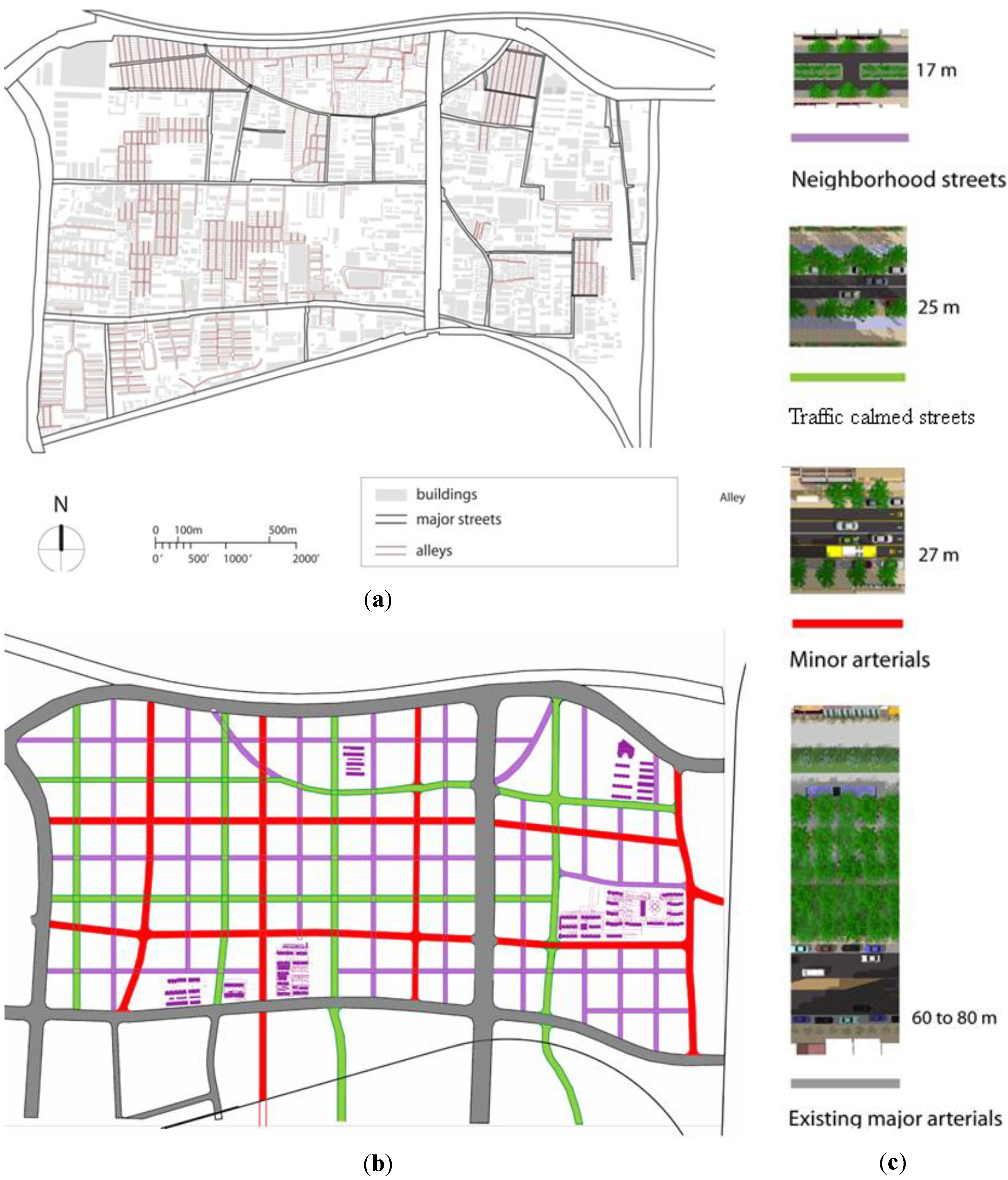
The key to making this workable is to also restructure the network to provide a wider variety of publicly accessible street types. The current street network is composed of only two types of streets, major arterials and small alleys that are for the most part accessible only to residents of the superblock (see
Figure 1a). Our plan introduces a hierarchy of publicly accessible streets, ranging from the existing major arterials, to narrow neighborhood streets (see
Figure 1b,c). The major arterials would continue to carry every type of traffic but would have more intersections than under the current design, and would require sophisticated traffic signal timing. An additional street type we introduce is the minor arterial, which would carry feeder bus lines to the BRT stations on the major avenues, and would feature wide bike lanes. We also introduce traffic-calmed streets with one narrow lane in each direction, where street design features would allow motor vehicle use but only at low speeds. The traffic calmed streets would include both bike lanes and sidewalks, and would handle some through traffic, but would not accommodate bus routes. They would connect in some cases to the major arterials but cross traffic might not be permitted. Finally, neighborhood streets would be provided for local access only.
Figure 1.
Luokou street network. (a) existing street network; (b) proposed street network; (c) types of streets.
Figure 1.
Luokou street network. (a) existing street network; (b) proposed street network; (c) types of streets.
2.2. Connecting to Downtown: Jiluo Avenue and the Importance of a Multimodal Approach
Jiluo, the main road linking the district to the city center, extends far beyond the project site and the project’s planning control. Even if the mixed use development and denser street network we propose would relieve some of the pressure on Jiluo, problems seem unavoidable if this one arterial must handle most of the traffic heading downtown. While a second arterial does connect through to other districts from the western edge of Luokou, it is neither as large nor as direct as Jiluo and is not likely to carry even half of the inter-district traffic. Other routes exiting the site are circuitous (e.g., using the ring road to reach other major arterials) or continue only a short distance before requiring traffic to return to Jiluo.
If Luokou land uses were able to capture a high percentage of the trips its residents make, and as a result few trips were generated to or from the district, our preliminary analyses indicate that the district street network could handle the traffic. However, if Luokou develops primarily as a residential district, so that large numbers of work trips are outbound towards downtown, Jiluo would almost certainly become heavily congested. In order to gain a better understanding of this situation, we simulated traffic conditions for the AM peak hour on Jiluo.
Lack of access to robust data was a major constraint in performing this traffic analysis. Without the necessary information to accurately model travel demand in the new development, we had to rely on a series of assumptions. In the absence of local trip generation rates we used rates from US sources [
13], and assumed that trip origins would be proportional to the sum of parcel-level trip generation estimates (based on land use and area of development) along each street. We adjusted these trip numbers to reflect the anticipated mode shares in Jinan, where long distance trips are split not only between cars and transit, but also include trips by bikes and electric bikes. We knew the current mode split in Jinan, and assumed it would be the same for Luokou.
Since Luokou is connected to the rest of the city by only two roads, Jiluo Avenue and a second, less direct route, all traffic bound for downtown would have to use one of these two routes, and our assumptions involved only the proportion of traffic carried by each street. We then tested different scenarios, considering both work and non-work trips in the am peak.
In the first scenario, we allocated half the peak period traffic to the peak hour, consistent with current travel patterns in the city. We estimated that some 4000 cars, 5500 bikes (regular and electric), and 31 articulated buses (150 passengers/bus) would travel southbound during the morning peak hour. With three car lanes in each direction, even with almost 70% green time for through traffic on Jiluo, it was clear that the street could not handle this traffic level; the queues spilled back to block the downstream intersections. We did not consider adding car lanes as a solution, since the focus of our work was to give priority to transit, walking and biking, and the street is already very wide. Adding car lanes would have worsened conditions for the other modes, and this was not justified from a sustainable development perspective.
In a second scenario, we assumed that, due to congestion on Jiluo, 40% of the peak hour traffic would divert to the other, narrower arterial. This reduced southbound traffic on Jiluo to 2400 cars, 3000 bikes and 18 articulated buses. In this case, the queues along Jiluo stopped short of downstream intersections, and the road network could handle the traffic flow exiting the district, though operating close to maximum capacity. However, further south of the site, another development is already using a significant share of Jiluo’s capacity; Luokou cannot claim it all. Thus, the diversion to other paths simply moves the bottlenecks to other locations.
The traffic analysis highlights the importance of strategies for jobs-housing balance and local services, to reduce the number of commuters to downtown by providing job opportunities in Luokou, and making sure that the type of housing and public amenities provided match the type of jobs present on site. In addition, our analysis suggests that greater attention should be given to efforts to increase people throughput on Jiluo and other major streets through effective transit planning.
2.3. Encouraging Other Modes
Observations elsewhere in Jinan have found that motor vehicle lanes are frequently carrying under 500 veh/lane/hr, mostly because of congestion and conflicts at intersections. In comparison, transit lanes, bike lanes and sidewalks all have the capacity to carry larger numbers of people. Our proposal for Luokou includes provisions for encouraging the use of transport modes that are less space intensive. For short distance travel, we gave walking and biking the highest priority. All our street designs incorporate bike lanes and bike parking facilities. We set a minimum sidewalk width of 3 m (10 ft), but often used sidewalks up to 8 m (25 ft) wide on major streets, with continuous tree canopy to create a comfortable environment in the summer, and landscaped medians or parking lanes between sidewalks and car lanes, for added safety. For longer trips, we gave priority to BRT, bikes, and e-bikes. On large arterials, such as Jiluo, we provide separate lanes for regular and e-bikes, so that they can travel at different speeds.
The BRT system in Jinan had developed as a separate project, and the decision to locate a BRT line on Jiluo Avenue had been made in advance to our involvement. We estimated the likely ridership on this BRT route as part our analysis of the Luokou district. To accommodate the expected mode split in Luokou, the BRT would need to carry 25% of all trips or about 4000 outbound bus trips during the AM peak hour. Accommodating this many riders would mean running a fully loaded articulated bus every two minutes (150 passengers/bus). Therefore, the BRT system would be running very close to its maximum capacity during peak hours. If outbound transit ridership were to exceed 25%, design capacity would be exceeded. An alternative would be to eventually replace the BRT with a higher capacity rail transit system [
14]. Alternatively, the development of multiple BRT lines into the area could be planned. In the interim, it would be important to develop advanced traffic management systems to avoid significant BRT delays at intersections.
2.4. Managing Multimodal Intersections
In the current street configurations, safety is a major concern for non-motorized transport modes. Every year, about 25,000 pedestrians are killed in traffic accidents in China, over twice as many as in the United States and the European Union combined [
15]. An estimated 60% of traffic fatalities in China involve pedestrians and bike riders [
16]. Our observations suggest that this is due to both driver behavior and poor street design. The large block sizes in Jinan and other Chinese cities mean that distances between signalized pedestrian crossings can exceed 600 m (2000 ft). Thus, a short journey from a residence situated in mid-block to a store just across the street can become a trek of over 1.2 km (4000 ft). Pedestrians frequently choose to simply cross mid-block, in unsafe conditions, rather than walk the extra distance to the signalized crossing. Our proposed street network, with smaller block sizes, provides a street crossing every 120 m (400 ft), or approximately five times as many crossings as the current configuration. We assume each would be signalized.
For bicycles, however, even signalized intersections can be unsafe if bikes are not given their own signal phases. This is particularly true for bikes trying to make left turns at major intersections. Since, in current street configurations, bike lanes are placed between car lanes and sidewalks, a left turn for a bike involves crossing all lanes of traffic, usually without a protected left turn signal. According to the projected mode split for the Luokou district, regular and electric bicycles together will capture an estimated 67,000 daily trips in 2020, 30% of total travel. Pedestrians will account for an additional 20% of the trips. Therefore, it is vital that street designs, and especially intersection configurations, carefully consider bike and pedestrian movements.
We developed guidelines for how the intersections between each type of street should be configured, focusing on pedestrian crossings and bike turning movements. The very wide existing streets, which will be retained in future plans, posed major design problems. A pedestrian moving at a speed of 1 m (3.3 feet) per second [
17] would need 80 s to cross the 80 m wide Jiluo Avenue. A bicycle moving at an average speed of 6 meters (20 feet) per second [
18] would cross Jiluo in about 14 s. In reality, since bicycles and pedestrians stop at a red light and queue, this time would be even longer for the entire queue to clear.
Given the large volumes of traffic expected on Jiluo, it seems unrealistic that cross streets could have over 80 s green signal time. The solution used in many Chinese cities, underpasses or overpasses, can work, though these options are costly to build, maintain, and provide security. Further, they are not entirely effective as pedestrians may continue to cross on the street level against the light or midblock even when there is an overpass or underpass. Another solution would be to acknowledge that pedestrians would not be able to cross major arterials in one phase, and to provide pedestrian refuges midway across major arterials. Still another approach would be to limit most street widths to four lanes or less, in order to allow safe and convenient crossings for slower, non-motorized modes. However, as the next section discusses, wider streets may have advantages from a building energy perspective that also should be considered.
2.5. Integrating Building Design: Street Width and Building Energy Use
Decisions on street widths and building densities can have significant impacts on building energy use. In order to gain a better understanding of the situation, we used building energy modeling software, Energy Plus [
19], to simulate the performance of a typical building in Luokou. We defined our typical building as an eleven-floor apartment building, with all units facing south. The building was placed on the north side of an east-west street, which was lined up with buildings of similar height. We determined that an average height of eleven floors was appropriate for the levels of density required for this district.
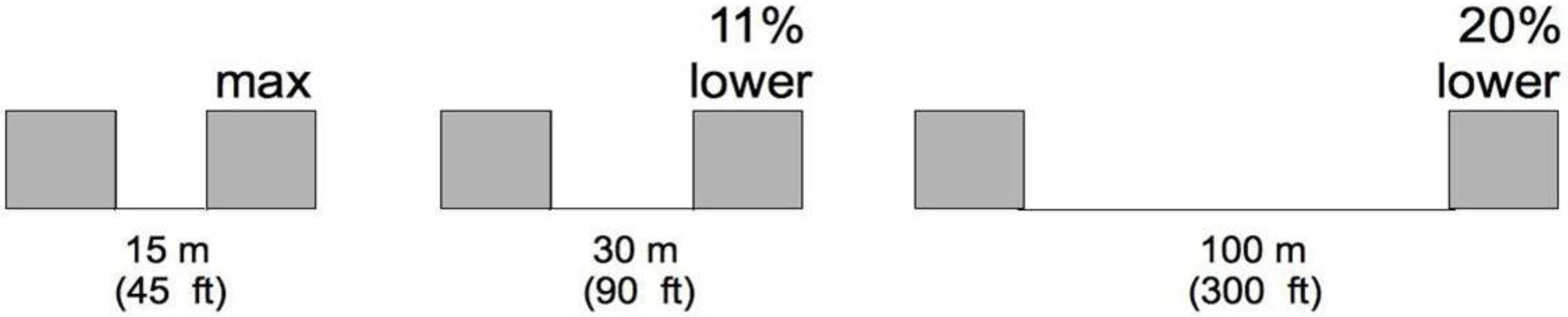
We ran a series of simulations of building energy use in the climate of Jinan, based on meteorological data from the United States Department of Energy, comparing the energy used for space heating, depending on street dimensions. We found that when increasing the street size from 15 m (45 feet) to 25 m (90 feet),
ceteris paribus, building annual energy use for heating went down by 11% (see
Figure 2). The explanation was that, on a wider street, the building on the northern side had more access to direct sunlight, which could be used for passive solar heating. When increasing street width from 15 m (45 feet) to the size of a major arterial, 100 m (300 feet) heating energy use went down by 20%. However, the same relationship could be accomplished with setbacks (landscaping or hardscaping) of similar size.
The 20% reduction in space heating loads should be regarded as a conservative estimate. According to our calculations, it is possible, through very aggressive design techniques, including very high thermal insulation and extremely high performance windows, to lower heating loads by as much as 50%. Space heating is the most important component of building energy use in China, accounting for over 54% of the total [
12]. Since this represents annual energy use, there was a corresponding increase in energy use for cooling, due to the unwanted solar heating in the summer. However, this problem can be remedied by adding appropriate window shading, which protects indoor spaces from overheating during the summer, while taking full advantage of solar heating in the winter. Due to the nature of the local climate in Jinan, with a longer heating season, buildings situated along wider streets or street/setback combinations will generally have a better environmental performance than those along narrower streets with little or no setback.
Figure 2.
Relationship between street width (or setback) and building energy use (space heating).
Figure 2.
Relationship between street width (or setback) and building energy use (space heating).
Street width also influences the amount of useful daylight that penetrates into a space [
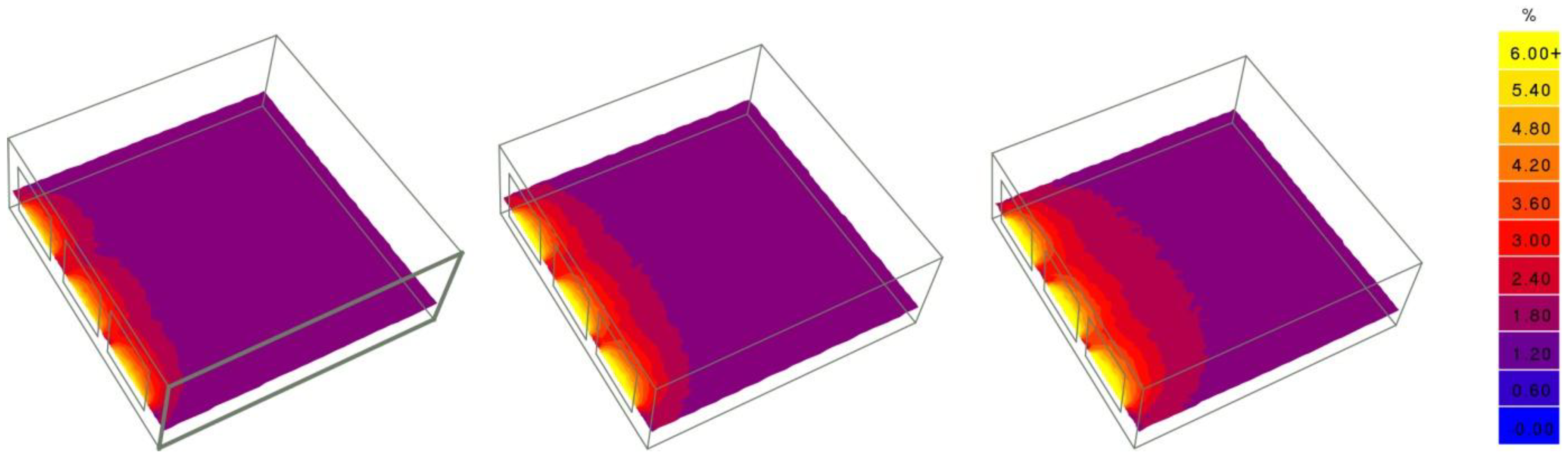
20]. This is particularly important for commercial and office buildings, where lighting is a significant energy load. Using the same three street widths from the previous example, we ran a different simulation, analyzing the amount of daylight in a typical office space, and how it changed with street width (see
Figure 3). The building on a wider street will always have more daylight available than one on a narrower street, offering the possibility to use fewer lighting fixtures during daylight hours; thus, saving energy. As opposed to the heating and cooling loads, this relationship does not depend on the local climate for generic flat sites, and is universally valid; though it can be impacted by variables such as street trees or location on hilly terrain.
Figure 3.
Daylight factor in an office space on a 15 m, 30 m and 100 m wide street.
Figure 3.
Daylight factor in an office space on a 15 m, 30 m and 100 m wide street.
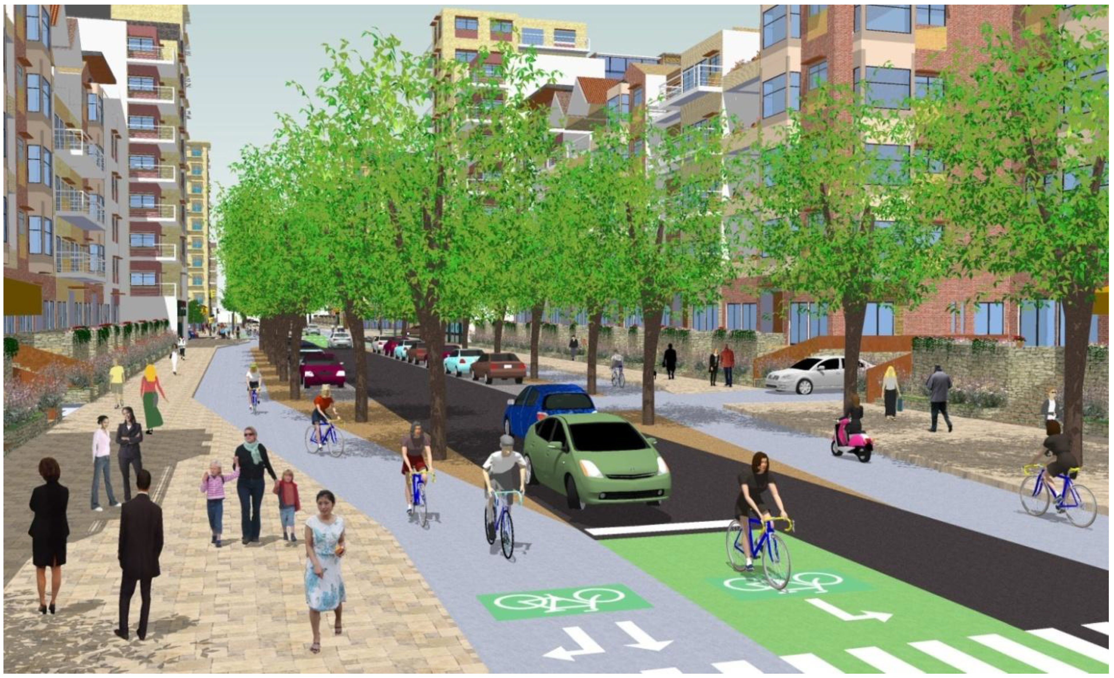
Based on our building energy analysis, we estimate that, by carefully considering building energy requirements in the early phases of planning a neighborhood, it is possible to reduce overall building energy consumption by over 25%. In the case of Jinan, this involves using generally wider streets or street/setback combinations. However, having previously noted the problems posed by wider streets to non-motorized modes, we sought a compromise between considerations for improved building performance and transportation sustainability, illustrated in our street design concepts (see
Figure 4). We also note that setbacks must be carefully designed to avoid creating a dead zone for pedestrians. Using additional space for well designed landscape, bike lanes, and wide sidewalks can be a way forward.
Figure 4.
Example of street and building design.
Figure 4.
Example of street and building design.
Looking at current building practices in new developments throughout the city of Jinan, we noticed that energy performance standards were significantly below recommended levels in comparable climate zones in the United States or Europe. Based on this finding, we performed a series of simulations in Energy Plus [
19], analyzing the potential for energy savings in buildings, by improving thermal insulation in walls, or using better performing window materials (see
Table 1). We found that by combining 20 cm thermal insulation in walls and roofs, with fixed window shading and low emissivity (low-E) glazing, it is possible to reduce building energy use by 68%, representing 152 GWh of total annual energy savings for the Luokou district compared to current building practices. As a comparison, in order to produce 152 GWh of electricity, a coal-fired power plant with a capacity of 2500 MW, such as the one in Dezhou, Shandong Province, would have to operate at full capacity for 60 h. However, current construction practices in the region often circumvent building code. Therefore, the energy efficiency gains from installation of better insulation and glazing would be a function of how closely the new energy requirements were followed.
Table 1.
Scenarios for achieving energy savings in buildings by improving the thermal insulation of walls and the performance of windows.
Table 1.
Scenarios for achieving energy savings in buildings by improving the thermal insulation of walls and the performance of windows.
| | Energy savings | Total energy savings for Luokou (MWh per year) | Annual cost savings per household (at 0.5 RMB/kWh) | Annual cost savings per household (% of an average income of RMB 13,600) | U value (values in bold meet EU standards) |
|---|
| Wall Thermal Insulation |
| existing (5 cm) | | | | | 0.73 |
| 8 cm | 4% | 8,496 | 106 | 1% | 0.49 |
| 10 cm | 6% | 14,256 | 178 | 1% | 0.40 |
| 12 cm | 7% | 14,868 | 186 | 1% | 0.34 |
| 15 cm | 8% | 17,928 | 224 | 2% | 0.28 |
| 20 cm | 10% | 22,680 | 283 | 2% | 0.21 |
| Window Materials |
| Existing (single pane windows) | | | | | |
| Double pane | 16% | 35,604 | 445 | 3% | |
| Fixed shading | 16% | 36,720 | 460 | 3% | |
| Low E glazing | 18% | 40,104 | 500 | 4% | |
| Double pane and low E | 34% | 76,212 | 950 | 7%% | |
3. Lessons Learned from an Integrated Planning Approach
Looking at Luokou and its larger urban context from the perspectives of land use, building energy performance, and transportation, we identified a number of lessons for making this district sustainable. A key lesson learned was that looking at sustainable development only from a building performance or transportation perspective, without considering how urban systems interact, can result in important opportunities being missed. For example, if we were concerned only with transportation sustainability, we would want to maximize building density in the vicinity of transit stops, in order to increase transit ridership. However, our building energy simulations have shown that, beyond a certain point, increasing building density lowers the potential for energy efficient building design. Though previous studies have noted problems due to overshadowing [
21], focusing exclusively on building performance can lead to recommendations such as increased setbacks, or a very low building density, which in return can adversely affect the pedestrian environment, or even lower transit ridership.
In Luokou, we recommended a range of residential densities throughout the district, between 54 and 109 units per acre, depending on the land uses present on the block, as well as a range for floor area ratios (FAR) between 2.6 and 2.9. These densities are high enough to promote extensive transit use, walking and biking. In addition, our building energy simulations indicate that by limiting FAR and residential densities to these values, we ensure optimal solar and daylight access for buildings, which is a key feature of sustainable building design. These density specifications are combined with urban design guidelines that control the quality of the pedestrian environment. We provided detailed recommendations on street design types, intersections, street sizes, and on associated building elements such as heights, window to wall ratios, facade thermal performance criteria, and specifications for window shading devices.
Simple design solutions such as a continuous tree canopy over sidewalks and bike lanes, continuous street frontage with ground floor retail, adequate street crossings, and careful intersection design can significantly improve conditions for non-motorized modes, and promote their use. This applies to both medium and long distance bike trips, and to biking and walking to nearby amenities. By encouraging the use of transport modes that are more energy efficient and less space intensive than the private car, we can reduce greenhouse gas emissions per kilometer traveled, and increase passenger throughput on major arterials. Increasing the connectivity of the network by using a grid pattern can significantly lower block sizes, with only a limited increase in total street area. This is important in order to distribute traffic over a larger number of routes, and provide more crossings for pedestrians. It does, however, require many more traffic signals and more sophisticated signal timing plans.
Overall, by studying the different systems together, and considering their interactions, we were able to provide a set of recommendations for Luokou for achieving much higher energy savings than could be achieved by planning for transportation or building energy efficiency separately. We placed the highest buildings along the widest streets and on major arterials which are also bus-rapid transit corridors. By increasing density in the proximity of transit stations, we improved pedestrian access to transit.
In areas where quiet, traffic calmed streets were desired, we designed narrow streets and matched them with lower building height along the street, to enhance the buildings’ energy performance. In some locations, residential buildings had to be higher to accommodate the planned number of households; there we used a wide street, measured curb to curb, but with wide sidewalks, bike lanes, and landscape instead of additional lanes for motor vehicles (see
Figure 4).


