Deep Geothermal Energy Production in Germany


Leibniz Institute for Applied Geophysics, Stilleweg 2, 30655 Hannover, Germany
*
Author to whom correspondence should be addressed.
Energies 2014, 7(7), 4397-4416; https://doi.org/10.3390/en7074397
Submission received: 5 May 2014
/
Revised: 17 June 2014
/
Accepted: 23 June 2014
/
Published: 9 July 2014
(This article belongs to the Special Issue Geothermal Energy: Delivering on the Global Potential)
Abstract
:Germany uses its low enthalpy hydrothermal resources predominantly for balneological applications, space and district heating, but also for power production. The German Federal government supports the development of geothermal energy in terms of project funding, market incentives and credit offers, as well as a feed-in tariff for geothermal electricity. Although new projects for district heating take on average six years, geothermal energy utilisation is growing rapidly, especially in southern Germany. From 2003 to 2013, the annual production of geothermal district heating stations increased from 60 GWh to 530 GWh. In the same time, the annual power production increased from 0 GWh to 36 GWh. Currently, almost 200 geothermal facilities are in operation or under construction in Germany. A feasibility study including detailed geological site assessment is still essential when planning a new geothermal facility. As part of this assessment, a lot of geological data, hydraulic data, and subsurface temperatures can be retrieved from the geothermal information system GeotIS, which can be accessed online [1].
1. Introduction
The importance of renewable energy is growing since it is evident that fossil fuel supplies are finite, politically vulnerable and responsible for climate change. Geothermal energy enjoys a special position amongst the renewable energy sources because it is available all year round, at any time of the day, and can therefore be used for base load energy, for both heat and power production. This paper focuses on deep geothermal energy resources in Germany. In contrast to shallow geothermal energy, deep geothermal energy can be used directly—with a much higher energy output and without the need to install a heat pump to raise the temperature.
In Germany, geothermal energy is defined as energy stored beneath the surface of the solid earth in the form of heat [2]. Although the last volcanic activities ceased in Germany approximately 10,000 years ago, there are many places where deep geothermal energy is available as an environmentally friendly alternative to fossil fuels. Its use helps to reduce the emission of greenhouse gases and to diversify the overall energy supply mix of Germany. The development of geothermal energy is supported by the German Federal Government in terms of project funding, market incentives and credit offers, as well as a feed-in tariff for geothermal electricity.
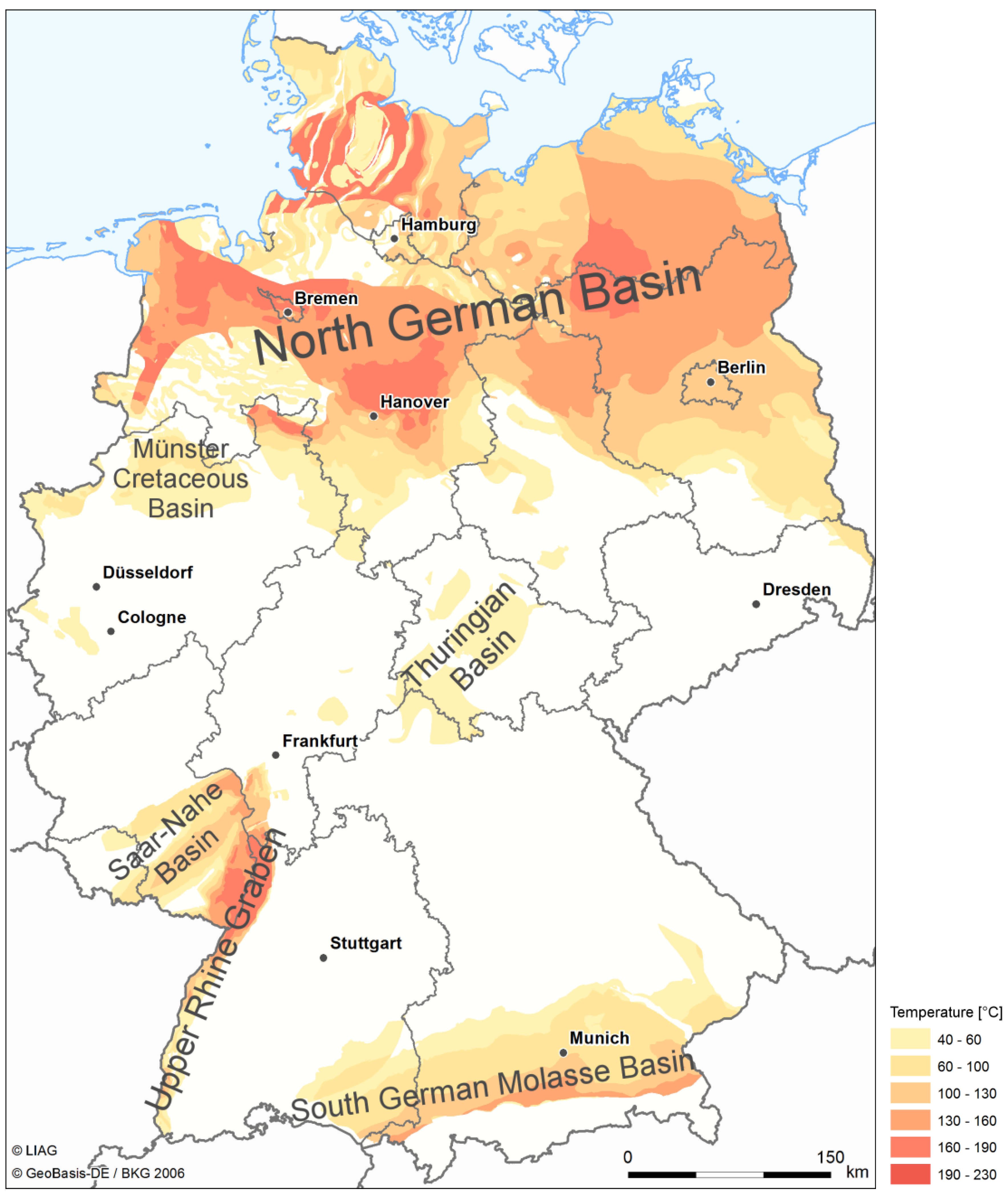
Unfortunately, the national geothermal resources are limited to intermediate and low enthalpy resources. All present-day geothermal installations use fluids with temperatures evidently below 180 °C. Nevertheless, an economic sector is developing rapidly to exploit the geothermal potential of these low enthalpy resources, which are typically located in deep sedimentary basin and graben structures. The most important geological settings for geothermal energy in Germany are deep Mesozoic sediments, which can be found in the North German Basin, the Upper Rhine Graben, and the South German Molasse Basin (reference [3] and references therein). Extensive, permeable and water-bearing sediments (aquifers) of at least 20 m thickness are referred to as geothermal reservoirs.
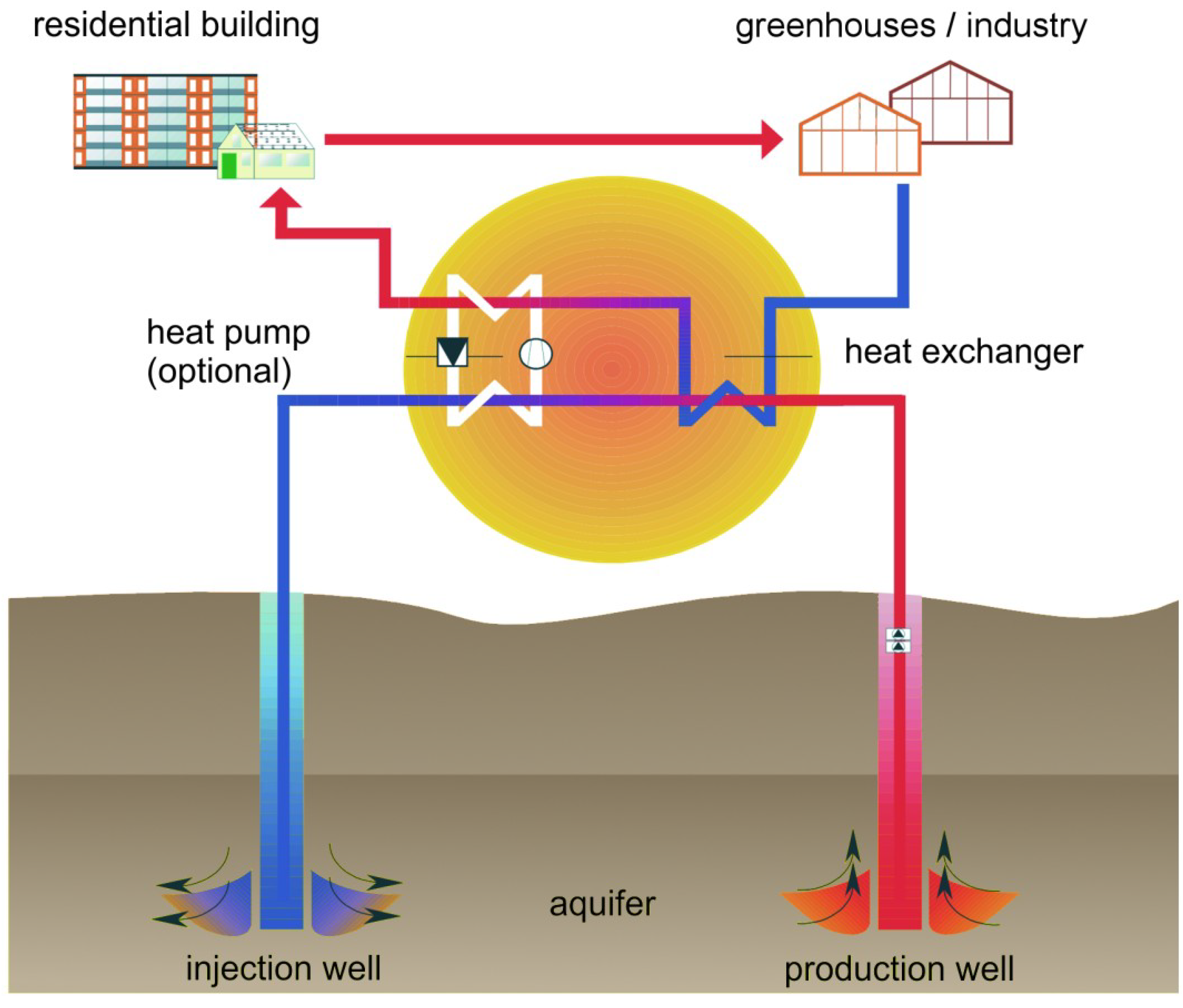
The average geothermal gradient, the increase in temperature per depth unit, is 32 K/km [4]. In some areas the gradient can reach values as high as 100 K/km. Aquifers at depths less than 400 m and temperatures below 20 °C are not considered as deep in the context of geothermal energy resources. Aquifers with thermal waters below 60 °C are usually used for spas in Germany. The usage of thermal waters in spas is generally realised with a single production well (singleton) and flow rates rarely above 15 L/s. Hence, these systems rely on the natural recharge of the aquifer. District heating stations usually require temperatures above 60 °C and much higher flow rates. Geothermal district heating is realised with two or more geothermal wells with at least one production well and one injection well (Figure 1). The re-injection of cooled geothermal fluids is necessary to maintain the pressure in the reservoir and in order to avoid the contamination of surface waters or shallow aquifers with high salt loads or even toxic fluid constituents. The flow rates for the primary cycle range from 35 L/s to 150 L/s. Combined geothermal heat and power production requires similar flow rates and additionally temperatures of at least 110 °C for economical operation. Modern conversion techniques such as the Organic Rankine Cycle or the Kalina cycle make it possible to generate power from fluids even below 100 °C. However, geothermal electricity production is still more expensive due to high investment costs than production by conventional coal fired or nuclear power plants in Germany. Geothermal power production is therefore not economical viable without the German Renewable Energy Sources Act (EEG) and the guaranteed feed-in-tariffs for renewable electricity producers. Currently, geothermal power plant operators receive 0.25 €/kWh. Petrothermally produced electricity is even worth 0.30 €/kWh, but no petrothermal-only project has been realised yet in Germany. The government plans a revision of the EEG for 1 August 2014. It is intended to abandon the petrothermal bonus of 0.05 €/kWh and to introduce obligatory direct-marketing for operators. The beginning of direct-marketing depends on the installed capacity. Longer adaption periods will be arranged for small facilities with less than 500 kW output. The additional costs for direct-marketing of geothermal electricity shall be compensated by increasing the feed-in-tariff from 0.25 €/kWh to 0.252 €/kWh. The direct-marketing concept increases financial risks but offers the chance to increase revenues if operators can raise power production at times when electricity prices at the European Power Exchange (EPEX SPOT SE) are higher than the monthly average.
Figure 1.
Diagram of a doublet for hydrothermal exploitation.

Today, combined heat and power production takes place in the alpine foreland (South German Molasse Basin) and along the upper Rhine valley (Upper Rhine Graben) due to the high geothermal potentials in these areas (Figure 2). Factors which have a major influence on the revenue include the achievable flow rates per well, the temperature and the attainable prices on the heat market. Factors which have a major influence on the costs include the exploration and drilling of reservoirs. Like other renewable energy technologies, geothermal projects also face elevated levels of financing risk due to high upfront costs. However, there are additional risks specific to geothermal. The drilling phase is much more capital intensive than all the previous phases, while still fraught with uncertainty. If the target formation of geothermal drilling turns out to be unsuitable for the project aims, a significant amount of investment is lost. Therefore, each geothermal project needs to be planned individually and must consider the great variation in the geological conditions of the deep subsurface.
Figure 2.
German regions with hydrothermal resources (proven and assumed) and associated temperature ranges. Map adapted from Suchi et al. [5] (copyright 2014 Leibniz Institute for Applied Geophysics (LIAG)).
Figure 2.
German regions with hydrothermal resources (proven and assumed) and associated temperature ranges. Map adapted from Suchi et al. [5] (copyright 2014 Leibniz Institute for Applied Geophysics (LIAG)).

2. Concepts of Geothermal Energy Production
2.1. Hydrothermal Systems
Hydrothermal systems make use of hot water in deep aquifers to produce geothermal energy. The conventional exploitation technique requires a production well to tap the hot water and a re-injection well for water disposal (Figure 1). The water is pumped to the surface where the stored heat is directly used or transferred to a secondary cycle (e.g., a district heating system) via a heat exchanger. In cases where the thermal water is characterised by a high level of salinity or gas concentration it is necessary to maintain the primary circuit under pressure in order to avoid the precipitation of minerals and resultant scaling.
Through a second well the cooled down water is then re-injected back into the same aquifer but at a specific distance to the source in order to keep up the productivity of the aquifer and to prevent a thermal breakthrough. This configuration, consisting of one production and one injection well, is called a doublet, however, there is also the possibility to extend the system by further wells of both types in order to enhance the performance of the installation.
Hydrothermal systems include aquifers which are classified on the basis of the water temperature: hot (above 100 °C), warm (between 60 °C and 100 °C) and thermal (at least 20 °C). Besides the temperature of the groundwater the productivity and injectivity of the wells are important parameters for the economic operation of geothermal plants.
Faults or fault zones can be attributed to hydrothermal systems as well. These geological structures promise a high geothermal potential [6] due to the fact that faults can represent connections to deep and hot rock formations and allow deep groundwater to migrate to shallower depths. In some cases faults and associated rising fluids even reach earth`s surface and can be exploited for balneological applications like for example in the city of Aachen where over 30 hot springs with water temperatures of up to about 70 °C can be found along two lineaments. In order to use these geological features as geothermal reservoirs in a safe and economic way further research has to be carried out to gain knowledge of the characteristics of different fault types like predominant stress and geological conditions, geochemical processes or the degree of permeability.
2.2. Petrothermal Systems
In the case of petrothermal systems thermal energy stored in deep rocks itself is exploited without any need of natural water-bearing rock formations. The most important parameter for petrothermal systems is the temperature at depth. Therefore regions with positive temperature anomalies are of particular interest for the exploitation of geothermal energy because sufficient temperatures can be achieved in shallower depths resulting in lower drilling costs.
In applications like Hot-Dry-Rock-Systems (HDR) or Enhanced-Geothermal-Systems (EGS) deep hot horizons (usually the crystalline basement) at depths of more than 3000 m with temperatures in the order of 150–200 °C are used as a heat exchanger to extract energy from the rock mass. Although the upper parts of the crystalline basement are thought to be fractured and show a certain level of permeability, it is necessary to enhance the network of fractures by stimulation procedures to create a heat exchanger of adequate size for an economic operation. This is usually accomplished by injecting large volumes of water after drilling the first well to increase permeability and migration paths by expanding natural and creating additional fractures (hydraulic stimulation). After successful stimulation a second well is drilled into the fractured zone in order to enable a circular flow: water pumped down the injection well absorbs heat from the hot rock while flowing through the fracture network and is produced from the production well. Like already mentioned in the section on hydrothermal systems precipitation of minerals in the usually oversaturated water can be limited by maintaining the cycle at elevated pressure. These systems are usually designed for the generation of electricity. The Leibniz Institute for Applied Geophysics (LIAG) is currently investigating the petrothermal potential of a 10 km × 12 km area in the Erzgebirge (Saxony) [7]. The idea is to develop the first petrothermal project in Germany.
Petrothermal systems can also be exploited by deep borehole heat exchangers (BHEs) installed in wells with depths ranging from 400 m to about 3000 m. Deep BHEs are closed systems in which a heat transfer medium (e.g., ammonia) is pumped down the annular space of a coaxial pipe system and gets heated by thermal conduction from the surrounding rock on its way down to the bottom of the heat exchanger. Via an insulated inner pipe the heated medium is brought back to surface where the thermal energy is extracted and used for supplying heat.
Operating deep BHEs in Germany exist in Arnsberg (North Rhine-Westphalia) with a total depth of 2835 m heating a spa, Prenzlau (Brandenburg, 2786 m, used for district heating) and Heubach (Hesse) providing heat for industry (773 m).
3. Key Parameters
A profound geothermal resource assessment requires a detailed knowledge of the geologic setting as well as thermal and hydraulic properties of the geothermal reservoir. The most relevant thermal parameter is temperature. Although the vertical temperature profile is approximately linear in many sedimentary settings, there are many locations where the vertical temperature increase is not linear due to strongly varying thermal conductivities within the sedimentary column or due to groundwater advection. The product of the geothermal gradient and the thermal conductivity relates to the heat flow density according to the Fourier equation of conductive heat transfer:
q = λ ∙ grad T
The heat flow density q quantifies the amount of heat per surface area and time. Its value is approximately 70 mW/m2 on average in Germany [8]. Without utilisation of geothermal energy, this amount of energy is lost to space. The largest contribution to the terrestrial heat flux is related to the decay of radioactive isotopes in crustal rocks. Another major contribution is the remaining heat from the formation of the Earth.
Records of subsurface temperatures exist from approximately 11,000 wells. Equilibrium temperature logs and reservoir temperatures are considered to be the best available data, which require no corrections. Because of the periodic monitoring of some production wells over many years, reservoir temperatures are available in time series; the fluctuation of these temperatures is mainly less than 1 K. Bottom-hole temperature (BHT) data are recorded in almost all industrial boreholes at the deepest point of the well immediately after drilling has stopped. The temperature field around a borehole is usually disturbed by mud circulation related to the drilling process. A number of methods to extrapolate from BHT to the undisturbed temperature have therefore been developed based on various assumptions about the cooling effect of the circulating mud and the thermal behaviour of the borehole and the surrounding rock [4,9,10].
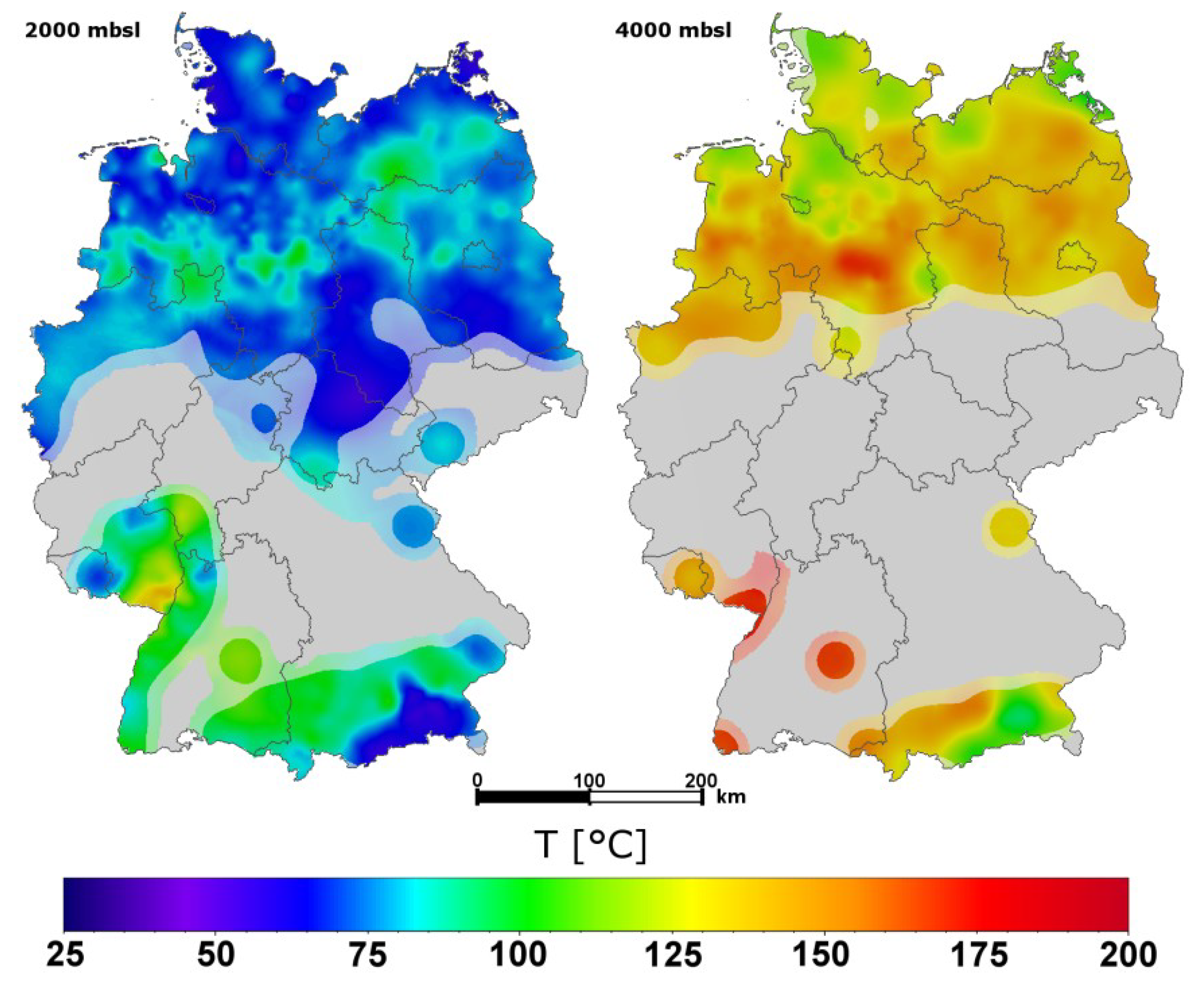
The average surface temperature in Germany is 8.2 °C. The highest temperature ever measured in a German borehole is 253 °C at a depth of 9063 m (KTB, Upper Palatinate). Figure 3 shows the subsurface temperature at 2000 m below sea level (mbsl) and 4000 mbsl. The maps represent horizontal sections of a geostatistical 3D temperature estimate based on measured data [4].
Figure 3.
Maps of subsurface temperature distribution (mbsl: meters below sea level).

Permeability and hydraulic conductivity describe the ability of a porous medium to let a viscous fluid pass through. The permeability characterizes the conductive properties of the rock matrix, only. The hydraulic conductivity characterizes the conductive properties of the system, including the specific weight and viscosity of the fluid. Hydraulic conductivity K and permeability k are related to each other by following equation:
![Energies 07 04397 i001]() where g is the acceleration due to gravity, ρ is the fluid density, and µ is its dynamic viscosity. The viscosity has a strong influence on the hydraulic conductivity. The viscosity of water essentially depends on the temperature while the influence of the pressure is rather small. For example, the hydraulic conductivity of an aquifer halves if temperature drops from 100 °C to 45 °C. Direct use applications generally require a hydraulic conductivity of at least 1 × 10⁻⁶ m/s.
where g is the acceleration due to gravity, ρ is the fluid density, and µ is its dynamic viscosity. The viscosity has a strong influence on the hydraulic conductivity. The viscosity of water essentially depends on the temperature while the influence of the pressure is rather small. For example, the hydraulic conductivity of an aquifer halves if temperature drops from 100 °C to 45 °C. Direct use applications generally require a hydraulic conductivity of at least 1 × 10⁻⁶ m/s.

Porosity and permeability data are available from drill core samples. Hydraulic tests estimate the transmissivity T, which is by definition equal to the integration of the hydraulic conductivities across the aquifer thickness H:
![Energies 07 04397 i002]()

T is measured in m2/s. It is possible to derive the transmissivity of porous aquifers from permeability data if the density and dynamic viscosity of the fluids are known [3]. A transmissivity of 5 × 10⁻⁵ m2/s, a porosity of 20% and an aquifer thickness of 20 m are considered as minimum values in order to achieve sufficient flow rates.
The productivity index (PI) is also frequently used to describe the hydraulic properties at a geothermal site. The PI comprises hydraulic properties of the tapped aquifer and well specific properties. The production index characterizes the production rate in relation to the pressure drawdown. A pressure drawdown of 1–3 MPa is typical for geothermal facilities [11]. In the case of injection wells, the injection index II is the analogue to the production index. It describes the injection rate in relation to the rise in pressure.
4. Project Planning
The successful development of a geothermal project requires detailed planning, a competent project management, and an effective cooperation of experts from many different fields. In Germany, a geothermal project for district heating takes six years on average. However, development time can vary, depending on the federal regulatory requirements, availability of a drilling rig and other factors. It can be divided into a series of development phases before the actual operation begins:
- (1)
- Preliminary Study (6–12 months)
- Definition of project objectives
- Data compilation
- Technical draft
- (2)
- Feasibility Study (12–24 months)
- Data acquisition
- Quantification of exploration risk
- Financial analysis
- (3)
- Exploration (18–24 months)
- Obtaining permits
- Seismic exploration
- First drilling
- Hydraulic tests and well stimulation
- Decision on strike
- (4)
- Field Development (18–24 months)
- Second drilling
- Hydraulic tests
- Construction of surface facilities
- Securing licence area at the local mining authority
- (5)
- Start-up and Commissioning (3–6 months)
4.1. Preliminary Study
The preliminary study of a geothermal project must point out the main objectives and possible barriers and risks. A compilation and analysis of available data on the geological setting is the starting point of each preliminary study.
Because it is always possible that the prospectivity of a geothermal reservoir penetrated by a borehole is worse than expected or even unsuitable, investors and project operators try to assess the exploration risk and insure against it if possible. The exploration risk therefore has to be precisely defined and used to quantify the probability of the economic success of a project. The exploration risk is defined as the risk of penetrating a geothermal reservoir with one (or more) borehole(s) with inadequate quantity or quality.
The quantity is defined here by the installed capacity of a geothermal plant:
where:
P = ρF ∙ cF ∙ Q ∙ (Ti − To)
| P | Capacity | W |
| ρF | Fluid density | kg·m−3 |
| cF | Specific heat capacity at constant pressure | J·kg−1·K−1 |
| Q | Flow rate, production rate | m3·s−1 |
| Ti and To | Input and output temperature of the geothermal plant | K |
The key parameters for the estimation of the capacity are production rate Q and temperature Ti (the temperature at the wellhead), which crucially depends on temperature TA in the aquifer. The production rate depends on the hydraulic conductivity of the tapped aquifer, the depth of the water table, the nominal output of the downhole pump, and the well design. While the first two parameters depend on the local geological setting, the latter two parameters are subject to technical and economic limits.
The quality of a geothermal reservoir mainly concerns the chemical composition of the fluid. Fluids may contain high content of dissolved gas and high salt loads. Materials exposed to hydrothermal fluids could be affected by corrosion. Depending on technology and selected materials, most fluid compositions encountered in Germany are manageable for geothermal exploitation. However, very strong saline fluids could pose a serious problem to the process of heat extraction due to precipitation of solids. Very high salt loads up to 330 g/L have been encountered in deep Mesozoic sandstones of the North German Basin. Fluids of deep aquifers in the Upper Rhine Graben exhibit generally lower salt concentrations. Here, highest salinity values observed are below 150 g/L. Most waters of the Upper Jurassic karst aquifer of the South German Molasse Basin have salt loads below 1 g/L [12].
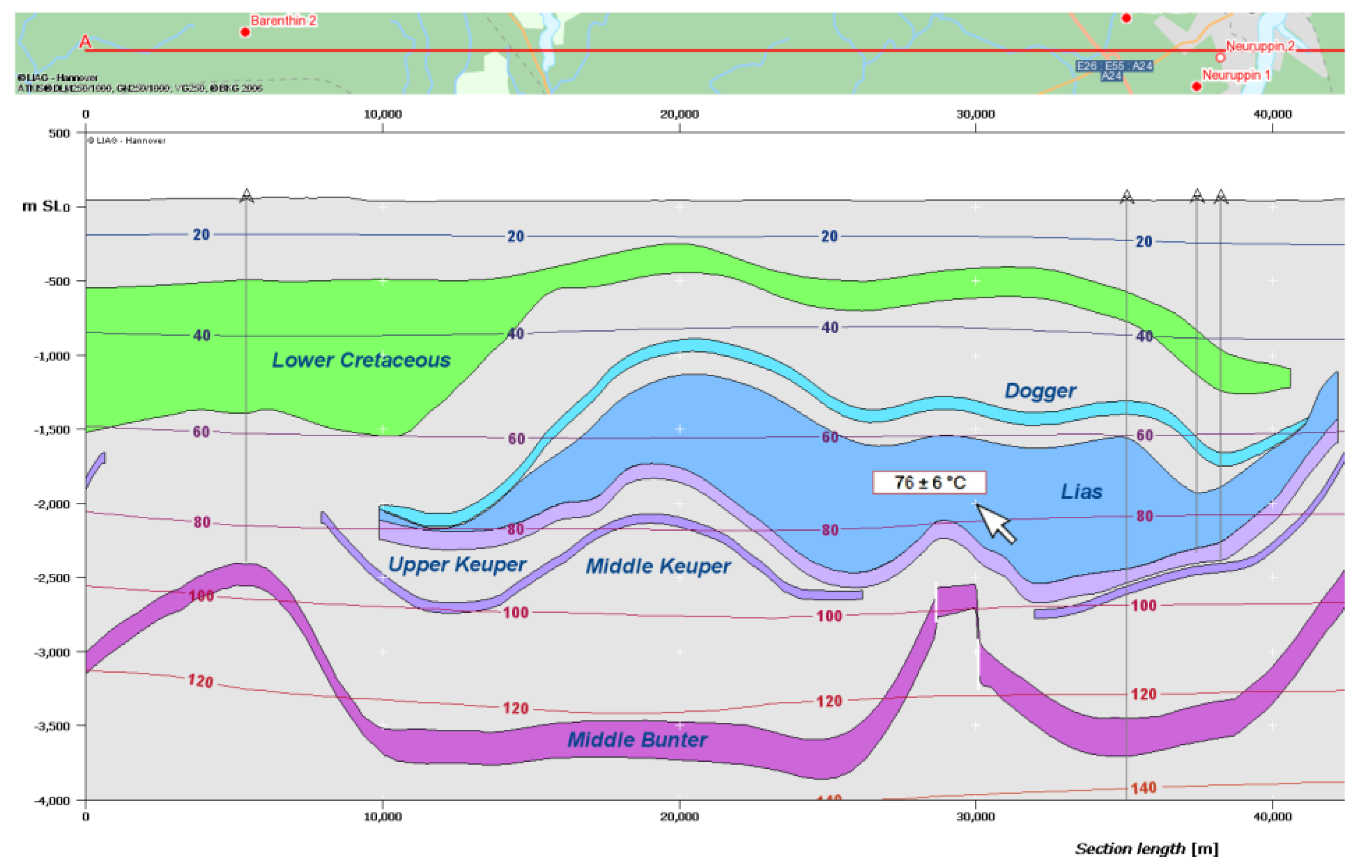
For assessing the exploration risk the project operator defines limits for TA and Q, above which a well can be considered a success. For a geothermal well, the probability of success can be estimated by determining the probability of each risk separately and by multiplying the single risks for flow rate and temperature [13]. The experience from other geothermal facilities in the same region also provides valuable information on the feasibility of a geothermal project. A major source of public data relevant for geothermal exploration in Germany can be found in the national geothermal information system GeotIS, which can be accessed online [1,3]. Basically, GeotIS is the digital version of a geothermal atlas. It offers a compilation of data and information about deep aquifers in Germany for possible geothermal use. Extent, depth and temperature of relevant geologic formations are presented for those regions of Germany most relevant to geothermal exploration. Surface and subsurface temperatures are provided where a sufficient amount of data is given. Both, temperature and geologic data have been compiled to state-of-the-art 3D-models. Views of the 3D content can be retrieved interactively by generating temperature plots on stratigraphic surfaces (Figure 4) or geologic cross sections (Figure 5).
Figure 4.
Screenshot of geothermal information system (GeotIS) showing an example of an interactive cross section through the eastern part of the North German Basin. Well locations (red) visible on the map strip are projected onto the cross section. Filled circles indicate wells with temperature data. A mouse-over-feature gives additional details of the well on the map strip and temperature values on the cross section. Colours of stratigraphic units, vertical exaggeration and z-axis can be adjusted by the user.

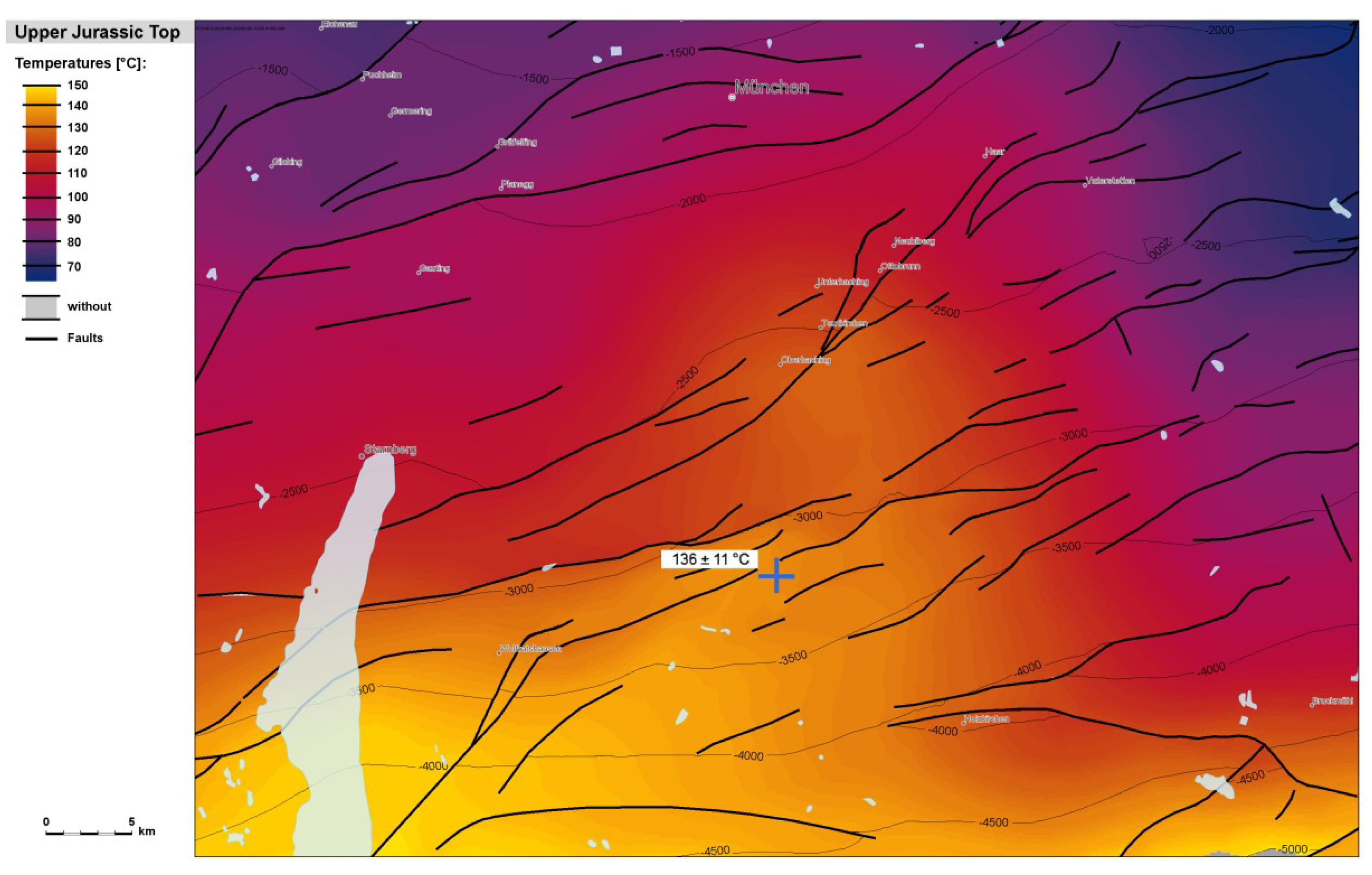
Figure 5.
Screenshot of GeotIS with a map of the subsurface temperature at the top of the Upper Jurassic formation (Malm) south of Munich (Bavaria). Bold black lines mark the location of faults in the Molasse Basin. The temperature scale adjusts automatically to the existing range of values in the selected area. A mouse-over-feature gives temperature values or the name of a well (not shown in this example). The superimposition of temperature, depth contours, fault lines and topographic features simplifies the first assessment of potential geothermal project locations.

The mouse pointer can be used to obtain a temperature prediction including an uncertainty range of any point in space of the subsurface. Maps of formation permeability are available as part of the information system for many regions of geothermal interest. Furthermore, data such as the locations of wells or seismic profiles can be displayed. In Germany, geothermal resources belong to the mining estate and the legal standard is the Federal Mining Law. The land owner is not the presumptive owner of deep geothermal. Exploration claims and exploitation permits (in German: “Erlaubnisfeld” and “Bewilligung”) are granted by the State mining authorities. A query about existing claims, permits, and special federal laws relevant for geothermal projects is therefore one of the first things to do.
Based on the expected geothermal potential and the general objectives, the preliminary study also provides a rough technical concept that outlines how geothermal energy is brought to the surface and distributed to the users. If it is planned to supply geothermal heat to residential or commercial buildings then existing and new district heating networks are as important to consider as a realistic estimate of the future demand and revenue. Peak demands in periods of extreme cold weather usually need to be backed by gas boilers.
The installation of a power plant results in additional costs but may help to compensate the seasonal fluctuations of the heat demand. Since the EEG guarantees feed-in-tariffs for geothermal electricity of currently 0.25 €/kWh, many geothermal facilities with reservoir temperatures above 110 °C combine heat and power production in Germany. Besides the potential revenues for electricity and heat, estimates of the costs for drilling and surface installations, access to further governmental incentives as well as interest rates on loans are also important aspects within the scope of the financial concept of a preliminary study. Both, prospective costs and revenues depend on site- and project-specific conditions.
4.2. Feasibility Study
The feasibility study continues and deepens the analyses of the preliminary study as it addresses the same questions but provides much more details. Seismic data, well profiles and borehole logs could be purchased in order to refine subsurface models. The depth level, size and hydraulic properties of the target formation need to be estimated and the uncertainty of this estimate quantised. An assessment of possible environmental impacts is also part of the feasibility study. A solid financial concept provides figures on estimated revenues, capital expenditures and operational expenditures. Capital expenditures include exploration, insurance to cover exploration risk, drilling, hydraulic testing/stimulation, and surface installations. Operational expenditures include operating staff, monitoring, maintenance, consumables, electricity, and provisions for depreciation. The decision to realise a project involves the general cost structure and an analysis of the levelised cost of energy of a geothermal facility. The calculation of the levelised cost of energy is based on the total costs throughout the economic lifetime of a geothermal plant in relation to the provided energy. It is therefore a commonly applied approach to compare different energy provision technologies with each other and with the prices that are paid on the energy markets.
Finally, the feasibility study outlines the exploration phase and provides a general project schedule. Mobilising capital and securing governmental support are important steps at this stage. Geothermal projects are usually developed by municipal or private companies in Germany. Within the frame of the market incentive programme (MAP) the German government offers low-interest loans (soft loans) and redemption grants to companies and municipalities. Since 2006 private insurance companies provide policies covering the exploration risk. The first private insurance worldwide covering the exploration risk related to geothermal drilling has been procured for the facility at Unterhaching [13]. Such policies mitigate the risk for investors. The project planner proposes to insure against failure of the drilling and stimulation activities, and defines lower limits for reservoir temperature or flow rate (or both). It is also possible to arrange for partial compensation in case of sufficient but lower than expected flow rates or temperatures. The insurance rate depends on geological setting, reliability of available data, involved risk, coverage extent, insurance sum, project location, and capital costs. The approval of a geothermal drilling plan relies on independent expertise. Insurance companies frequently ask the LIAG to assess the probability of success of geothermal projects. The LIAG provided more than 50 expert reports for investors and insurance companies since 2002.
4.3. Exploration
When the feasibility study turned out to be promising, then the next step is the commissioning of a company for the project management. In Germany, it is highly recommended to organise information events for the local public beforehand in order to mitigate initial concerns about new infrastructure. Before exploration can begin, the project planner needs to apply for an exploration claim at the State mining authority. In order to obtain the exploration claim, it is required to prepare an operating plan and to inform the State mining authority on all intended exploration methods. In Germany, 3D seismic surveys are common practice for the exploration of geothermal resources in sedimentary settings. These 3D seismic surveys are conducted by specialised firms. Seismic data and lithologic well profiles are the best basis for the development of stratigraphic 3D models. Even the reprocessing of older 2D seismic data can provide valuable information. Seismic surveys may also reveal structural information on permeable joints in rock masses without bedding. The results of the seismic survey are also used to find the optimal drilling site and drill paths. The next step is the invitation to bid for the first wellbore. After its completion, hydraulic tests reveal if sufficient high yields can be achieved with a reasonable drawdown. Stimulation measures may help to improve the hydraulic properties of the well. Temperature measurements and a detailed analysis of the fluid chemistry provide further important data. They are needed for decisions on the right technology of the power plant, the dimensioning of the surface installations and the materials used. If the first borehole fails to meet the criteria outlined in the project objectives, the investors may stop the project or drill a side-track. They might also find a substitute geothermal project with lower requirements. If the project continues the project planner develops a work plan and applies for an exploitation permit at the State mining authority. The term is usually for 50 years but a prolongation is possible.
4.4. Field Development
The development phase starts with the invitation to bid for the second wellbore. The technique of directional drilling enables drilling from a single site, intersecting near vertical faults, penetrating the target formation in low angles, and achieving the optimal distance of the landing points of the production and injection well. If the distance in the reservoir is too small the fluid temperature cannot be maintained over the entire lifetime of the system. On the other hand, the distance in the reservoir should not be too large in order to maintain a sustainable yield of the production well.
Productions tests, stimulation measures if needed, and interference tests between the two boreholes complete the drilling and testing activities. The decision on which well to use for production and injection is based on temperature and hydraulic data. A higher temperature at the production well increases the energy output. A greater transmissibility is advantageous for the injection well because cooling a geothermal fluid increases its viscosity. The planning of production and reinjection strategies of a geothermal plant is supported by numerical reservoir models.
The next step comprises the construction of the geothermal plant, the installation of pipelines from the well heads to the geothermal plant, and the connection to a district heating network. The development of geothermal district heating networks is often accomplished in subsequent stages.
The commissioning is the final phase before the geothermal plant starts to supply heat and electricity to the clients on a regular basis. It can take several months to check all components, resolve technical problems, and to optimise operation.
5. Environmental Impact
There will be an initial environmental impact as the geothermal plant is set up. The construction of roads, pipelines and buildings requires energy related to transport and manufacturing of materials. The drilling, testing and stimulation of wellbores also requires energy and causes noise. Since geothermal wells are often drilled in urban areas, efficient noise protection walls are mandatory. The impact on the environment caused by drilling and construction works normally ends once all facilities are built.
The development of enhanced geothermal systems involves hydraulic stimulation which could cause seismicity. The high-pressure injection of water during stimulation lowers the threshold value for rupture by reducing the effective frictional resistance along fault planes. Within sedimentary settings, this induced seismicity is rather low and rarely causes irritation. However, hydraulic stimulation in crystalline bedrocks is more likely to cause sensible seismic events. The extent of surface effects and possible damages of a seismic event can be related to the ground velocity at the surface. The German standard DIN4150 considers a peak ground velocity of 5 mm/s as non-hazardous for almost all building categories.
Induced seismicity can also occur during operation of a geothermal plant. The largest seismic events have been reported for the geothermal plant at Landau. After two years of stable operation, two seismic events with magnitudes of 2.4 and 2.7 in August 2009 resulted in the obligation to reduce primary circulation although no significant damage occurred. Smaller induced seismicity has been reported for the geothermal plant at Unterhaching (Bavaria). Here, seismicity was probably related to the injection of water into a fault system. Induced seismicity resulting from thermal stress generated by re-injection of cooled water is subject to current research.
The amount of land necessary for the construction of a geothermal plant is generally small compared to other renewable energy technologies. Drilling geothermal wells requires space for a drilling pad large enough to allow the manoeuvring of the drilling rig and to store drill pipe, casing, and other equipment. Typically, drilling pads for deep geothermal projects require a total area of 4000–5000 m2. After completion of drilling and site restoration the land use footprint depends on the type of geothermal facilities installed. A district heating station requires much less space than a combined heat and power production unit with air-cooled condensers.
6. Geothermal Installations
6.1. Overview of Geothermal Installations in Germany
Although only low and intermediate enthalpy resources are available in Germany, some regions are quite suitable for generating geothermal heat for direct use or even for power production. Germany uses its low enthalpy resources predominantly for spas, space heating, and district heating. Intermediate enthalpy resources are mainly used for district heating and in some cases even for power production. Figure 6 gives an overview on the location of geothermal facilities in Germany.
Figure 6.
Geothermal installations in Germany.

There are 23 facilities with an installed capacity above 1 MW which supply heat for district heating networks and/or produce electricity for the national grid (see Table 1). The map and the table have been derived from the GeotIS [1], which contains more detailed information and data on geothermal power plants, heating stations and spas in Germany that are in operation or under construction. For each installation, details such as installed capacity or mean power production are provided. Statistics on geothermal power and heat production are available on an annual basis.

Table 1.
Selected operating parameters of major geothermal installations in Germany. TVD: true vertical depth.
| Location | Installed capacity (MW) | Production (GWh/a) | Wellhead temperature (°C) | Production rate (L/s) | Depth (m TVD) | Stratigraphy | Reporting year | ||
|---|---|---|---|---|---|---|---|---|---|
| Power | Heat | Power | Heat | ||||||
| North German Basin | |||||||||
| Neubrandenburg * | - | - | - | - | 65–78 | 11–28 | 1268 | Rhaetian | 2011 |
| Neustadt-Glewe | - | 4.0 | - | 17.6 | 97 | 11–35 | 2450 | Rhaetian | 2012 |
| Waren | - | 1.3 | - | 3.1 | 63 | 17 | 1565 | Rhaetian | 2012 |
| Upper Rhine Graben | |||||||||
| Bruchsal | 0.4 | - | 1.2 | - | 123 | 24 | 2542 | Middle Bunter | 2013 |
| Insheim | 4.3 | - | 14.2 | - | 165 | 65 | 3800 | Basement | 2013 |
| Landau (Palatinate) | 3.0 | 5.0 | 13.2 | 3.0 | 159 | 40 | 3291 | Bunter, Basement | 2012 |
| South German Molasse Basin | |||||||||
| Aschheim | - | 9.8 | - | 48.7 | 85.4 | 39–75 | 2630 | Malm | 2013 |
| Dürrnhaar ** | 5.5 | - | - | - | ca. 135 | ca. 130 | 4114 | Malm | - |
| Erding | - | 10.2 | - | 37.6 | 62–63 | 6–36 | 2359 | Malm | 2013 |
| Garching | - | 8.0 | - | 10.2 | 74 | 100 | 2226.3 | Malm | 2012 |
| Kirchstockach ** | 5.5 | - | - | - | 138.8 | ca. 120 | 3881.6 | Malm | - |
| München (Riem) | - | 12.0 | - | 48.0 | 94.5 | 35–85 | 2747 | Malm | 2011 |
| Oberhaching | - | 38.0 | - | 48.8 | 127.5 | 137 | 3755.2 | Malm | 2013 |
| Poing | - | 9.0 | - | 37.0 | 76.2 | 100 | 3049 | Malm | 2013 |
| Pullach *** | - | 11.5 | - | 45.7 | 104 and 80 | 55 and 23 | 3505 | Malm | 2013 |
| Sauerlach **,*** | 5.0 | 4.0 | - | - | ca. 140 | 110 | 4480 | Malm | - |
| Simbach-Braunau | - | 7.0 | - | 48.0 | 80.5 | 61.1 | 1941 | Malm | 2013 |
| Straubing | - | 2.1 | - | 2.9 | 36.5 | 17.5 | 824.8 | Malm | 2011 |
| Traunreut ** | - | 7.0 | - | - | ca. 108 | 50 | 4645.8 | Malm | - |
| Unterföhring | - | 9.5 | - | 29.0 | 86 | ca. 75 | 1986 | Malm | 2012 |
| Unterhaching | 3.4 | 38.0 | 6.9 | 107.6 | 123.3 | 120 | 3590 | Malm | 2013 |
| Unterschleißheim | - | 8.0 | - | 40.1 | 78 | 65–93.3 | 1960 | Malm | 2013 |
| Waldkraiburg | - | 16.4 | - | 2.8 | 109 | 20 | 2718 | Malm | 2012 |
| Total | 27.1 | 200.7 | 35.5 | 530.1 | - | - | - | - | - |
* heat storage facility; ** recent commissioning; and *** triplet.
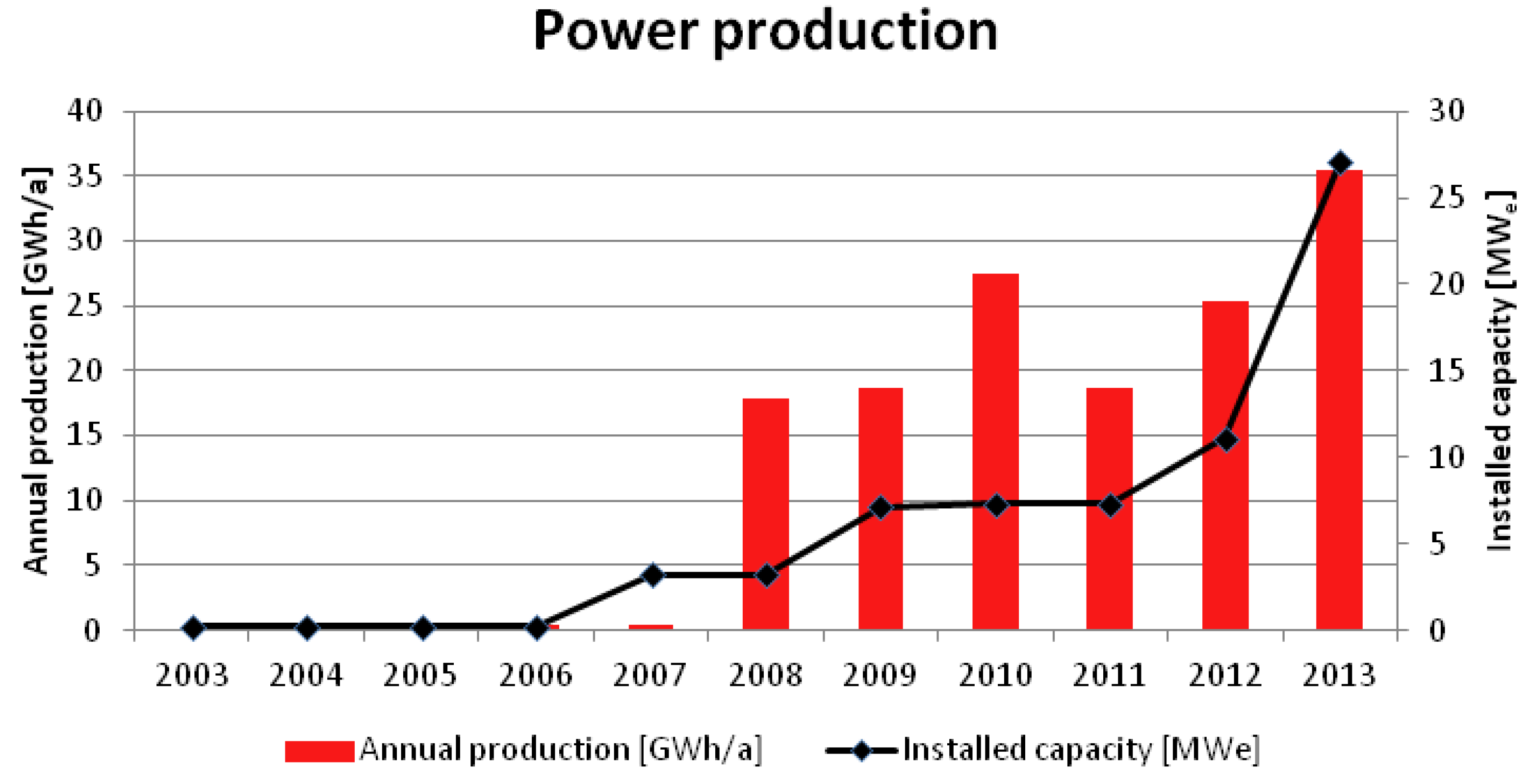
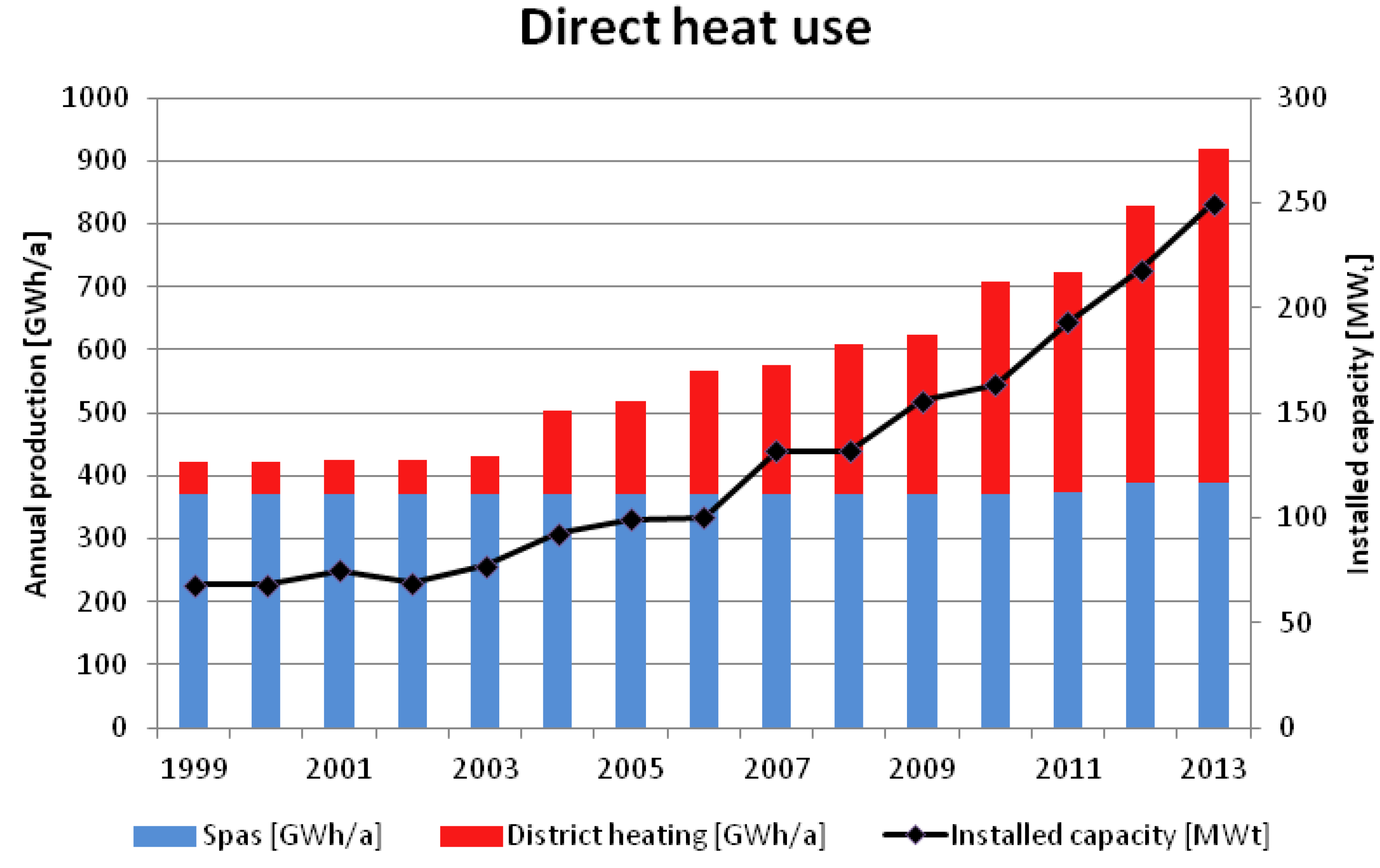
Currently, seven of the plants listed in Table 1 produce about 35.5 GWh/a of geothermal power with a total installed capacity of 27.1 MW (Figure 7). Compared to 2012, the capacity for power generation has more than doubled. In the case of heat production 18 of the plants mentioned above with an installed capacity of approximately 200 MW provide 530 GWh/a for district heating networks (in some cases combined with power generation). Together with 167 spas located predominantly in Southern Germany the total annual geothermal heat production in Germany sums up to about 920 GWh/a at an installed capacity of nearly 250 MW (Figure 8).
Figure 7.
Geothermal power production in Germany.

Figure 8.
Geothermal direct use (spas and district heating) in Germany.

6.2. Geothermal Installations in Northern Germany
In this part of Germany thick Mesozoic sandstone formations represent the most important aquifers for geothermal utilisation. These include sandstones of the Lower Cretaceous, Middle Jurassic as well as reservoirs in the Rhaetian and Liassic sandstones and the Middle Bunter. These formations are widespread and show, especially in north-eastern Germany, favourable properties regarding porosity, permeability and temperature. Besides, the Rotliegend sandstones and the Schilfsandstein of the Middle Keuper are considered as locally promising target horizons for geothermal exploitation [14,15,16,17].
The most important geothermal projects in north-eastern Germany include the heating plants in Waren and Neustadt-Glewe as well as the heat storage facility in Neubrandenburg which exploit the sandstones of the Rhaetian/Liassic aquifer complex.
6.3. Geothermal Installations in the Upper Rhine Graben
The geological formations of the Upper Muschelkalk and the Bunter show the highest potential for hydrogeothermal utilisation in the Upper Rhine Graben. In addition, the Hauptrogenstein (Middle Jurassic) located in the southern part of the graben and a Tertiary sequence in the northern part provide suitable conditions for geothermal exploitation. A relatively high temperature gradient indicates the upwelling of deep waters (with high salinity) along fault zones and fissures. This advantageous condition allows the generation of power at all of the larger geothermal facilities located in the Upper Rhine Graben (Bruchsal, Insheim, and Landau (Palatinate); compare Table 1).
6.4. Geothermal Installations in the South German Molasse Basin
The Malm (Upper Jurassic) represents by far the most important water-bearing horizon in southern Germany. Due to the fact that the high permeability of the partially karstified Malm limestones and dolomites allows high production rates (>100 L/s) from depths exceeding 4000 m this geological formation is today the main target for geothermal exploitation in the South German Molasse Basin. The temperature of the usually low mineralised waters is bound to the depth of the Malm horizon which crops out in the north in the Swabian and Franconian Alb but declines to depths below 5000 m when approaching the Alps [18]. For this reason geothermal power generation using thermal water with temperatures up to 140 °C is only possible to the south of Munich whereas farther to the north the main utilisation is aimed at supplying energy for district heating networks. Because of the geological conditions and the proximity to a large number of potential consumers, the area around Munich is one of the best developing regions of Germany in terms of geothermal utilisation. The Pullach geothermal plant has been extended from a doublet to a triplet with a reversal of an injection well to a production well. With the recent commissioning of Dürrnhaar, Kirchstockach, Sauerlach (triplet) and Traunreut the number of operating geothermal facilities in Bavaria amounts to 17 plants whereof four are generating geothermal power (see Table 1). Further projects are already in the stage of construction.
Despite the high density of geothermal installations around Munich there is almost no mutual interference between neighbouring installations. Dussel et al. [19] simulated hydraulic and thermal effects in the reservoir for the proposed lifetime of 50 years on the basis of a numeric thermo-hydraulic 3D model. They predict temperature changes after 50 years of operation in the vicinity of injection wells, only. Hydraulic interferences are generally low. The maximum effect between to installations has been estimated with up to 0.3 MPa.
7. Summary and Outlook
Presently, there are 180 geothermal direct-use installations in operation. The installations comprise district heating, space heating in some cases combined with greenhouses and thermal spas. Most of the district heating plants are located in the Bavarian part of the Molasse Basin. From 2003 to 2013, the annual power production increased from 0 GWh to 36 GWh. At the end of 2013, geothermal power generation in Germany reached an installed capacity of 27.1 MWe. However, most geothermal energy is used for heating. From 2003 to 2013, the annual production of geothermal district heating stations increased from 60 GWh to 530 GWh. In 2013, the total installed capacity for geothermal heat production reached 250 MW. Buildings are responsible for about 40% of final energy consumption in Germany. There is still an enormous potential for geothermal direct use installations. Deep geothermal energy accounts for 0.62‰ of total heat supply and 6.92‰ of heat supply from renewable energy sources. Geothermal power production is growing rapidly but on a very small level. It merely accounts for 0.06‰ of total power production and 0.23‰ of green power production in Germany.
Ganz et al. [20] expect that due to an exciting new project development in Southern Germany, the installed capacity of geothermal power production will exceed 50 MWe by 2015 and the installed capacity of deep geothermal heat use may reach 300 MWt in 2015 with an annual heat production of about 1075 GWh. Information on geothermal energy use in other countries can be found in Ganz and Schulz [21] and Ganz et al. [22].
The GeotIS provides up-to-date figures on geothermal facilities and annual geothermal energy statistics for Germany, which are used for national energy statistics on renewable energy, as well as in international reports [22].
Petrothermal energy is of high potential in Germany and could play an important role in German energy production in the long term. A German petrothermal system is currently developed in Saxony. The LIAG has performed a 3D seismic survey in a 10 km × 12 km area in the year 2012 to explore a petrothermal reservoir in a granitic body located in the Erzgebirge. The objective is to develop a detailed 3D model of the subsurface down to a depth of 6 km and to identify and characterise potentially permeable fracture zones as targets for a geothermal borehole using a petrothermal system.
A detailed geological site assessment is still essential when planning a new geothermal facility. As part of this assessment, a lot of geological data, hydraulic data, and subsurface temperatures can be retrieved from GeotIS. The public system offers a wide range of tools to visualise key parameters in regional contexts. It helps to identify promising locations for geothermal projects and provides relevant information and data for preliminary and feasibility studies. However, it is important to note that GeotIS does not replace local feasibility studies.
Acknowledgments
This paper has greatly benefited from data and information provided by GeotIS, which was funded by the Federal Ministry for the Environment, Nature Conservation and Nuclear Safety and is currently funded by the Federal Ministry for Economic Affairs and Energy under project number 0325623A. The authors are grateful to Peter Bayer and two anonymous reviewers for useful comments and suggestions which helped to improve this paper.
Author Contributions
Thorsten Agemar outlined the content and structure of the paper. He prepared Section Section 1, Section 4 and Section 5. He also contributed to Section 3. Josef Weber is responsible for the energy statistics and provided Section 2 and Section 6. Rüdiger Schulz had the initial idea for this manuscript and contributed to all sections, especially to Section 3. Thorsten Agemar and Josef Weber have carried out literature review and finalized the manuscript.
Conflicts of Interest
The authors declare no conflict of interest.
References
- Geothermal Information System for Germany. Available online: http://www.geotis.de (accessed on 1 July 2014).
- VDI-Richtlinie 4640 (Blatt 1): Thermal Use of the Underground Fundamentals, Approvals, Environmental Aspects; Gesellschaft Energie und Umwelt (VDI): Berlin, Germany, 2010; p. 33.
- Agemar, T.; Alten, J.-A.; Ganz, B.; Kuder, J.; Kühne, K.; Schumacher, S.; Schulz, R. The geothermal information system for Germany—GeotIS. Z. Dt. Ges. Geowiss. 2014, 165, 129–144. [Google Scholar]
- Agemar, T.; Schellschmidt, R.; Schulz, R. Subsurface temperature distribution in Germany. Geothermics 2012, 44, 65–77. [Google Scholar] [CrossRef]
- Suchi, E.; Dittmann, J.; Knopf, S.; Müller, C.; Schulz, R. Geothermal Atlas to visualise potential conflicts of interest between CO2 storage (CCS) and deep geothermal energy in Germany. Z. Dt. Ges. Geowiss. 2014, in press. [Google Scholar]
- Paschen, H.; Oertel, D.; Grünwald, R. Möglichkeiten der Geothermischen Stromerzeugung in Deutschland; Sachstandsbericht, Arbeitsbericht 84; Büro für Technikfolgen-Abschätzung beim Deutschen Bundestag (TAB): Berlin, Germany, 2004. (in German) [Google Scholar]
- Lüschen, E.; Schulz, R. 3-D seismic surveys explore German petrothermal reserves. EOS Trans. Am. Geophys. Union 2014, 95, 237–244. [Google Scholar] [CrossRef]
- The Global Heat Flow Database of the International Heat Flow Commission. Available online: http://www.heatflow.und.edu/data.html (accessed on 24 April 2014).
- Hermanrud, C.; Cao, S.; Lerche, I. Estimates of virgin rock temperature derived from BHT measurements: Bias and error. Geophysics 1990, 55, 924–931. [Google Scholar] [CrossRef]
- Förster, A. Analysis of borehole temperature data in the Northeast German Basin: Continuous logs versus bottom-hole temperatures. Pet. Geosci. 2001, 7, 241–254. [Google Scholar]
- Wolfgramm, M.; Franz, M.; Agemar, T. Explorationsstrategie Tiefer Geothermischer Ressourcen am Beispiel des Norddeutschen Beckens. In Handbuch Tiefe Geothermie; Bauer, M., Freeden, W., Jacobi, H., Neu, T., Eds.; Springer Spektrum: Heidelberg, Germany, 2014; pp. 451–493. (in German) [Google Scholar]
- Wolfgramm, M.; Seibt, A. Zusammensetzung von Tiefenwässern in Deutschland und ihre Relevanz für Geothermische Anlagen. In Proceedings of the Der Geothermiekongress 2008 Conference, Karlsruhe, Germany, 11–13 November 2008; pp. 503–516. (in German).
- Schulz, R.; Pester, S.; Schellschmidt, R.; Rüdiger, T. Quantification of Exploration Risks as Basis for Insurance Contracts. In Proceedings of the World Geothermal Congress, Bali, Indonesia, 25–30 April 2010.
- Katzung, G. Geothermie-Atlas der Deutschen Demokratischen Republik; Zentrales Geologisches Institut (ZGI): Berlin, Germany, 1984. (in German) [Google Scholar]
- Feldrappe, H.; Obst, K.; Wolfgramm, M. Die mesozoischen Sandstein-Aquifere des Norddeutschen Beckens und ihr Potential für die geothermische Nutzung. Geol. Wiss. 2008, 36, 199–222. (in German). [Google Scholar] [CrossRef]
- Obst, K.; Brandes, J.; Feldrappe, H.; Iffland, J. Geologische Karte von Mecklenburg-Vorpommern,Übersichtskarte 1:500.000—Nutzhorizonte des Rhät/Lias-Aquiferkomplexes; LUNG Mecklenburg-Vorpommern: Güstrow, Germany, 2009. (in German) [Google Scholar]
- Obst, K.; Brandes, J. Geologische Karte von Mecklenburg-Vorpommern,Übersichtskarte 1:500,000—Nutzhorizonte im Mittleren Buntsandstein; LUNG Mecklenburg-Vorpommern: Güstrow, Germany, 2011. (in German) [Google Scholar]
- Stober, I.; Fritzer, T.; Obst, K.; Schulz, R. Tiefe Geothermie—Nutzungsmöglichkeiten in Deutschland, 3rd ed.; Federal German Ministry for the Environment, Nature Conservation and Nuclear Safety: Berlin, Germany, 2011. [Google Scholar]
- Dussel, M.; Lüschen, E.; Thomas, R.; Agemar, T.; Fritzer, T.; Sieblitz, S.; Huber, B.; Bartels, J.; Wolfgramm, M.; Wenderoth, F.; et al. Development of a Thermo-Hydraulic 3D Model of the Deep Carbonatic Malm Aquifer in the Munich Region (Germany) with Special Emphasis on a 3D Seismic Survey. In Proceedings of the European Geothermal Congress, Pisa, Italy, 3–7 June 2013.
- Ganz, B.; Schellschmidt, R.; Schulz, R.; Sanner, B. Geothermal Energy Use in Germany. In Proceedings of the European Geothermal Congress, Pisa, Italy, 3–7 June 2013.
- Ganz, B.; Schulz, R. The GIA Trend Report, a New Survey Report about Geothermal Applications and Developments with Trends in Power Generation and Heat Use in IEA-GIA Member Countries. In Proceedings of the European Geothermal Congress, Pisa, Italy, 3–7 June 2013.
- Ganz, B.; Bendall, B.; Bromley, C.; Busby, J.; de Gregorio, M.; Ketilsson, J.; Kumazaki, N.; López Ocón, C.; Minder, R.; Muller, J.; et al. Trends in Geothermal Applications; Survey Report on Geothermal Utilization and Development in IEA-GIA Member Countries in 2011, with Trends in Geothermal Power Generation and Heat Use 2000–2011; International Energy Agency (IEA)-Geothermal Implementing Agreement: Taupo, New Zealand, 2013. [Google Scholar]
© 2014 by the authors; licensee MDPI, Basel, Switzerland. This article is an open access article distributed under the terms and conditions of the Creative Commons Attribution license (http://creativecommons.org/licenses/by/3.0/).
Share and Cite
MDPI and ACS Style
Agemar, T.; Weber, J.; Schulz, R. Deep Geothermal Energy Production in Germany. Energies 2014, 7, 4397-4416. https://doi.org/10.3390/en7074397
AMA Style
Agemar T, Weber J, Schulz R. Deep Geothermal Energy Production in Germany. Energies. 2014; 7(7):4397-4416. https://doi.org/10.3390/en7074397
Chicago/Turabian StyleAgemar, Thorsten, Josef Weber, and Rüdiger Schulz. 2014. "Deep Geothermal Energy Production in Germany" Energies 7, no. 7: 4397-4416. https://doi.org/10.3390/en7074397