Communication

An Exploratory Assessment of a Smartphone Application for Public Participation in Forest Fuels Measurement in the Wildland-Urban Interface

by
Colin J. Ferster
1,*,
Nicholas C. Coops
1,
Howard W. Harshaw
2,
Robert A. Kozak
3 and
Michael J. Meitner
1
1
Department of Forest Resources Management, Faculty of Forestry University of British Columbia, 2424 Main Mall, Vancouver, BC V6T 1Z4, Canada
2
Faculty of Physical Education and Recreation, University of Alberta, W1-16E Van Vliet Centre, Edmonton, AB T6G 2H9 Canada
3
Department of Wood Science, Faculty of Forestry, University of British Columbia, 2424 Main Mall, Vancouver, BC V6T 1Z4, Canada
*
Author to whom correspondence should be addressed.
Forests 2013, 4(4), 1199-1219; https://doi.org/10.3390/f4041199
Submission received: 28 August 2013 / Revised: 26 October 2013 / Accepted: 11 December 2013 / Published: 16 December 2013

Abstract

:
Wildfire management in the wildland-urban interface (WUI) protects property and life from wildland fire. One approach that has potential to provide information about the amount and location of fuels to forest managers and, at the same time, increase public knowledge and engagement in reducing wildfire threats is public participation in scientific research (PPSR)—also known as citizen science—where members of the public participate in the research process. In this exploratory study, residents of a wildfire-affected community tested a smartphone application to collect data about forest fuels and answered questions about wildfire, their community, and experiences using the application. In this paper, the application is introduced, the volunteers’ motivations, attitudes, and behaviors are considered, and the potential of using a PPSR approach for wildfire management discussed. Although there are practical challenges to applying PPSR approaches to wildfire hazard management, the participants in this study demonstrated the potential of PPSR to increase awareness and understanding of actions that can reduce the threat of wildfire. Wildfire managers may consider utilizing PPSR approaches to engage the community in wildfire preparedness.

1. Introduction

In many wildland-urban interface (WUI) areas, where unoccupied forests meet human development, wildland fires can threaten human life and structures [1]. Over time, the policies of fire exclusion have resulted in changes to forest structure, contributing to more intense and severe wildfire events with the potential to disrupt the lives of people living nearby and to destroy their property. Forest fuels are structural components of forests that can combust in wildfires. Forest managers engage in activities that aim to reduce or modify the fuel available to wildfires near priority areas (such as communities), thereby reducing the severity and size of wildfires and making fire suppression efforts more effective. Forest fuel management activities in the WUI may include controlled burns, thinning tree stems, pruning branches, clearing brush and other ground fuels, chipping, or planting fire resistant species. To effectively prescribe fuel management plans, in addition to knowledge of the ecology and fire history of a stand, fire managers require information about the size, shape, type, and arrangement of fuel components [2]. As forest fuels within broad, spatially heterogeneous areas can change rapidly (e.g., fallen branches after a wind event), they require frequent re-measurements for effective monitoring. These data can be time consuming and expensive to collect [3]. Effective wildfire management also requires understanding, cooperation, and action by adjacent civic units (cities, municipalities, parks), private property holders, and other members of the community. For example, when municipalities apply fuels treatments to public lands, such as manually reducing the amount of fuels at a treatment site, the selected treatment(s) may not be effective unless adjacent property owners also reduce fuel loads on their land. Community members have an important role in reducing the ignitability of their residence by performing fuel reduction activities and using fire resistant landscaping building and landscaping materials [4]. In Canada, Partners-in-Protection provides publications recommending actions that homeowners can take to reduce the likelihood of their home igniting when wildfires occur. These actions include clearing a defensible space around the house, using fire resistant landscaping, and reducing brush around the perimeter of their property [5].
Currently, in British Columbia, fire managers complete fuel assessments and prescribe fuel modifications on public lands (such as mechanical treatments and controlled burning), seek public support for fuel modifications on public land, and advocate for personal action on private lands (such as homeowners choosing fire resistant building materials and using fire resistant landscaping). Due to the complexity of land ownership and management responsibility in the WUI, fuels treatments on public land may not be effective unless strategies are coordinated across the mosaic of land jurisdictions [1]. Fire managers in many regions also seek to build trust through citizen-agency relations, encourage community knowledge and engagement in protection planning and mitigation activities, and enhance a sense of shared responsibility for fire hazard in the WUI [6]. In a survey of fire managers in Alberta, Canada, communication between municipal fire managers and community residents was achieved using a wide variety of strategies, including pamphlet and newsletter distribution, newspaper or radio advertising, website notices, tradeshow booths, open houses, door-to-door meetings, and providing wildfire mitigation advice to homeowners. However, despite many fire managers expressing an interest in more two-way communication with the public, they cited funding, time, and availability of personnel as limitations to engagement and communication with people in the community [6]. Public acceptance of fuel management actions is generally associated with knowledge of wildland fire management, and it also depends on building trust through long-term citizen-agency relations [7].
One approach that may assist forest managers to effectively prescribe fuels treatments, and at the same time, enhance the ability of a community to take preventative actions to reduce wildfire threats is public participation in scientific research (PPSR, also commonly called citizen science). In PPSR members of the public engage in “intentional collaborations to generate new science-based knowledge” in projects that “aim explicitly to contribute to scientific research and/or monitoring” [8]. Although the monitoring of natural resources to inform management decisions is not typically focused on purely scientific research related activities, such as formulating and testing new theories, the approaches are informed by science and the data that are collected may be used to generate new scientific knowledge. In addition, approaches developed in PPSR can readily be applied to the task of monitoring resources, (e.g., members of the public can monitor of the health and status of ecosystems). PPSR approaches can encourage conservation in residential ecosystems, where citizens help study and manage ecosystem well-being, promote positive social outcomes (such as changes in attitudes that contribute to ecosystem conservation), and feedback is provided that can be used to iteratively refine conservation and project goals [9]. Shirk et al. [8] identified several potential outcomes of PPSR approaches, including scientific advances, personal growth (for those who participate), and more effective resource management in communities. PPSR has been applied in fields such as ornithology to engage volunteers in projects and the data have been used to inform resources management. For example, in ornithology, Project FeederWatch [10] and eBird [11] have engaged broad audiences to collect and share bird survey data by providing opportunities to learn about ornithology and sharing lists of sightings with other birder watchers. Approaches inspired by PPSR may provide opportunities to reach outcomes for individuals and communities that are desirable for wildland fire management. For example, interactive and hands-on methods of engagement have been demonstrated as effective methods to increase public knowledge of fire management activities [12] and for building relationships between agencies and the public [13]. Applying approaches inspired by PPSR to wildfire management could provide a mechanism for forest managers to interact with people in communities, share information to increase public understanding of wildland fire management, build agency trust by demonstrating tradeoffs in decision making in real-world situations, and foster a sense of shared responsibility.
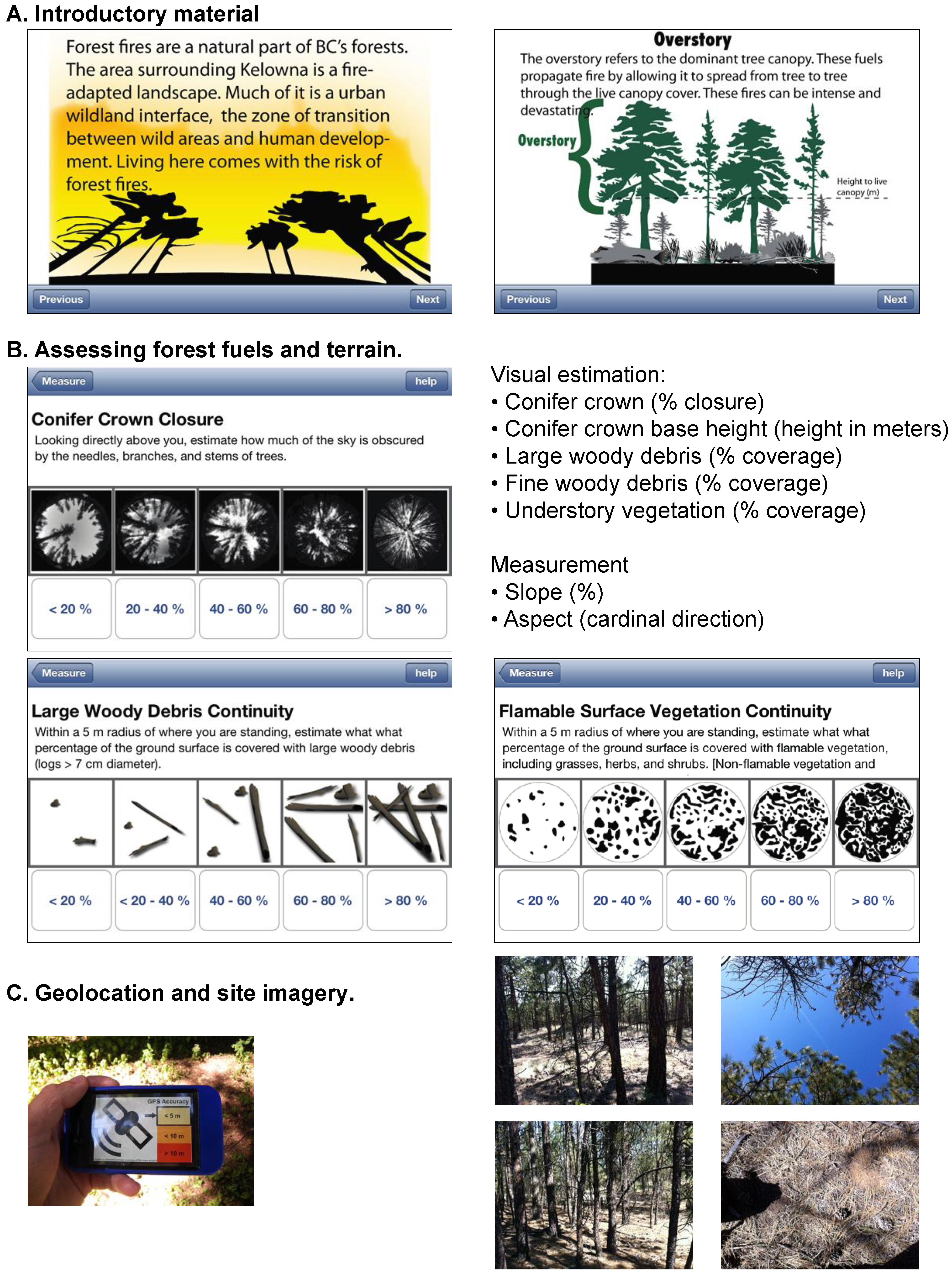
Recent advances in personal computing and mobile communications technology have increased the number of opportunities for public participation in science and natural resources management. In particular, personal electronic devices, such as smartphones, provide capabilities for people to collect information about forest structure from the ground and human perspective. This has the ability to provide data at spatial and temporal resolutions that compliment data collected by Earth observing satellites [14]. Smartphones are equipped with a touchscreen for viewing and entering data, sensors (including cameras to collect imagery), global positioning systems (GPS) to collect geolocation, compasses and accelerometers for measuring direction and angle, and the ability to store and transfer data over a network. An increasing proportion of the population has access to smartphones, providing the potential to collect smartphone measurements across broad geographic extents [15]. For example, an application developed by the British Geologic Survey allows the public to document temporary geologic exposures, for example, when soil strata or underlying bedrock are temporarily exposed to the surface by excavation for construction that would otherwise be “lost to science” [16]. Smartphone applications have been developed for professional geologists to aid in collecting notes, photos, and making field observations so that they are collected in a consistent and accessible manner [17]. A smartphone application was developed to facilitate community-based monitoring by individuals who had been hired without previous experience measuring forest disturbances as a part of regional monitoring efforts [18]. The Red Cross released a wildfire application for smartphones designed to provide the public with instructions for preparing for an evacuation, games to teach evacuation preparedness, wildfire warnings, wildfire locations and movement, evacuation notices, assistance in locating services or help in the event of a wildfire, and a tool to help alert family after a safe evacuation [19]. These approaches can be extended to forest management in communities for topics such as forest fuel loading in the WUI. However, there is a need to evaluate the role of these types of programs in communities, including challenges such as volunteer participation incentives, risk, liability, and personal privacy.
In addition, there are similarities between recent PPSR efforts and environmental volunteerism (such as urban tree planting) that may be analyzed to better understand the links between volunteering, collecting data for PPSR, and the expanding role of technology. For example, the Volunteer Function Inventory (VFI) has been employed to understand the motivations of volunteers in an urban tree planting project [20]. The VFI is a model that hypothesizes six functions that are served by volunteerism, and these may be used as a tool to assess individual motivations for volunteering [
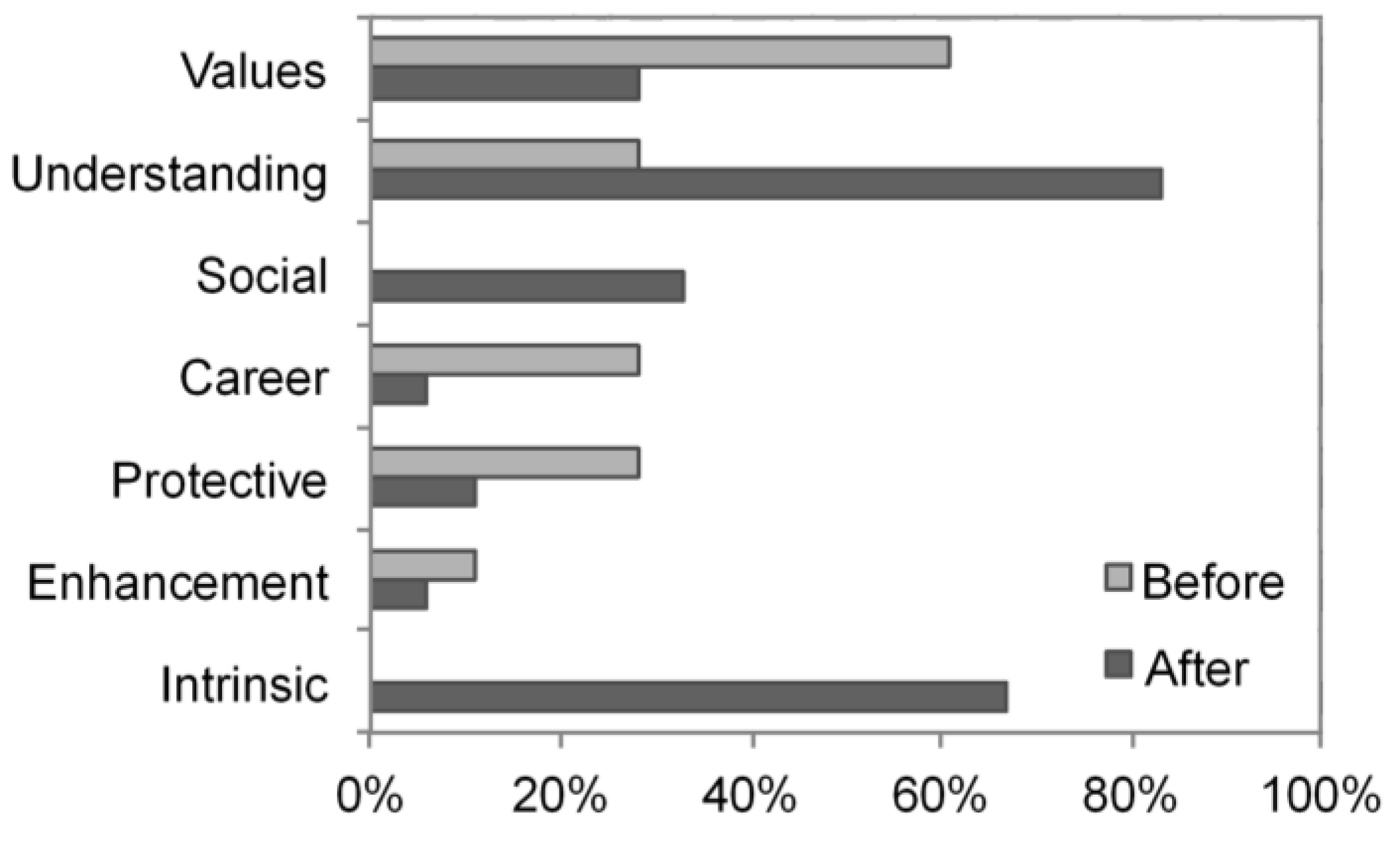
21]. The functions in the VFI are values (e.g., humanistic or altruistic), understanding (providing new learning experiences, or a chance to practice skills), social (building relationships with others), career (seeking career related benefits), protective (volunteering to escape negative feelings), and enhancement (focused on personal growth). Utilizing the VFI to analyze motivations in PPSR projects may allow researchers to understand and compare the motivations of volunteers and may also enable project designs that engage the target audience for recruitment and continued participation by volunteers.
The purpose of this exploratory study is to increase understanding of the social and management implications of a PPSR-inspired smartphone application for wildfire management. Public involvement may provide additional forest fuel loading data to forest managers both on public land (where ongoing monitoring of conditions takes place), and on private land (which forest managers may not typically have access to) and a smartphone application may provide a mechanism with which the public can gather and provide information. However, the role the application may fill needs to be evaluated for each potential use. In this study, we developed a smartphone application and examined whether it was a suitable technology for forest fuel loading data acquisition by people with a range of experiences living in a wildfire-affected community. Participants were asked to complete paper-based questionnaires before and after using the application to collect forest fuel loading data in order to help us to understand their experiences. In this manuscript we address three main points. First, we introduce the smartphone application. Second, we consider participants’ demographic characteristics and previous experiences related to wildfire and how these influenced motivations for getting involved with the project and experiences using the application to collect data, including how professionals and non-professionals approached a similar task. Third and finally, using these results as a guide, we discuss how a smartphone application inspired by a PPSR approach may fit into wildfire management in communities in the WUI.
This manuscript describes exploratory research that was conducted as a first step in understanding the challenges and possibilities of applying a smartphone application inspired by PPSR methods as a tool for measuring forest structure to inform wildfire management decisions in the WUI. The findings of this work are not meant to be conclusive, given the limited sample at a single location at a single point in time. Rather, we aim to provide insight to, or a proof of concept of, an approach which has many challenges, but which also holds considerable potential for both providing more information to forest managers and providing a way for members of communities that are vulnerable to forest fires to participate in forest and wildfire management.

2. Methods

2.1. The Forest Fuels Measurement Application

The application was designed and implemented by the research team with three activities. The first activity was an introductory slideshow with definitions for terms and concepts related to forest fuels (Figure 1A). The second activity was a visual rapid classification of fuel conditions, aided by reference images and illustrations (inspired by the Photoseries and Photoload rapid assessment techniques evaluated by Sikkink et al. [22]; Figure 1B). In the third activity, participants took six pictures of the fuel components at the site (in four directions at right angles relative to the direction of ground slope, straight up at the forest canopy, and straight down at the forest floor) and measured the location using the global positioning system (Figure 1C). The data collected by participants can be exported to a spreadsheet format so the data from multiple devices can be collected over a network for analysis. The application was designed so the data collected was compatible with the official protocol for professionals measuring forest fuels in British Columbia, Canada [23]. The protocol uses five classes for each forest fuel component, and assigns a point value to each class, allowing foresters to prioritize stand fuels treatments. Background material along with illustrated instructions were developed and provided both as a set of introductory slides and in a series of help screens available at each step, with the intent of teaching non-professionals to take the measurements and collect data. The application was implemented for Apple iOS 6.0 on an iPhone 4 device, but it could be implemented on any smartphone platform with a touchscreen, camera, GPS, accelerometer, data storage, and networked data transfer. Also, the application was designed to function where cellular service is not available by saving the data on the device while in the field; however, GPS acquisition can take longer when out of cellular range, and network connectivity is required to transfer measurements to a central server for collection and analysis.
Figure 1. Examples from the forest fuels application, including (A) introductory material, (B) rapid visual assessment and measurement, and (C) collection of imagery.
Forests 04 01199 g001

2.2. Application Testing, Observational Data, and Questionnaires

The study area was located in a WUI area in Kelowna, British Columbia. In this region, risk of wildfire is highest during the dry summer months. For example, the Okanagan Mountain Fire of 2003 necessitated the evacuation of 27,000 people and consumed 239 homes. The project was staged at the University of British Columbia Okanagan (UBCO) campus, where a range of forest structure conditions and forest fuel loadings are accessible within a short walk from campus on publicly accessible land endowed to, and managed by, the University of British Columbia, along right-of-way trails managed by the City of Kelowna, and in a city park managed by the City of Kelowna.
For this exploration of the technology, participants were recruited using the following methods. Posters were put up at local coffee shops, public bulletin boards, and in local classified advertisements. These were placed one month in advance of the study and were maintained for the duration of the study. Neighborhood associations and recreation groups in the surrounding area were found using local listings available on the City of Kelowna website and using Internet search terms “Kelowna outdoors club” and “Kelowna hiking club” and were contacted by email two weeks in advance of the first visit. Professional contacts were made by email, which were subsequently forwarded to a broad group of wildfire professionals throughout British Columbia. Finally, stories about the research were published by several local newspapers (Vancouver Sun 30 July, Kelowna Daily Courier 2 August, Vernon Morning Star 3 August, Barrier Star Journal 5 August), radio stations (CBC 30 July, CKNW 16 August), and a television station (CHBC 8 August), and these stories included links to the project webpage (or mentioned the project webpage) which contained the recruitment information. Any inquiries about participation were followed up by contact by email or telephone and all possible efforts were made to accommodate any interested participants. Refreshments were offered as a token reward for participation.
The demographic characteristics of the participants are summarized in Table 1. Participants were met individually between June and October 2012 at the UBCO campus and asked to complete an initial paper-based questionnaire to provide information about previous experiences, behaviors, and attitudes related to wildfire and wildfire management. Participants were then provided with a smartphone with the forest fuels application running and asked to collect forest fuel loading data in areas adjacent to the campus while accompanied by at least one researcher. Participants spent between 25–120 min collecting data. Observational data (for example, participants’ reactions, statements, and questions about wildfire and the use of the application) was collected throughout the course of the experiment. After collecting the forest fuels data using the smartphone application, the participants completed a second paper-based questionnaire investigating their experiences collecting data with the application.
Table 1. Demographics of participants. The mean reported age was 45 years.
ItemResponse (count)Response (%)
Gender
 Male1372%
 Female528%
Education
 High school16%
 Some college or university528%
 College or university degree1056%
 Graduate degree16%
 No answer16%
Occupation
 Retired528%
 Student422%
 Provincial wildfire manager211%
 Provincial forester211%
 Regional/civic forester211%
 First nations wildfire manager16%
 Store manager16%
 Bookkeeper16%
Place of residence
 Rural633%
 Suburban739%
 Urban528%
Respondents indicated their answers using five-point Likert scales (from 1 = “Strongly Agree” to 5 = “Strongly Disagree”), checked boxes with discrete answers (for example, “Have you been evacuated in a wildfire before?”), or wrote longer answers to open-ended questions (for example, “The part of the project I enjoyed most was…”). Student t-tests for independent samples were used as a tool for comparing means between groups for the Likert scale questions (α = 0.05), which were determined directly from answers to questionnaire items (Table 2). Due to the small sample size, only groupings with at least a 60%/40% or better proportional balance were compared. One section of questions that asked about attitudes and behaviors related to wildfire management was repeated in the first and second questionnaires to evaluate whether there was a change in the way participants answered questions before and after using the application to collect forest fuels data. For these repeated questions, Student t-tests for paired (dependent) samples were used to compare means (α = 0.05).
Open-ended questions about motivation and enjoyment were coded using the definitions of the five VFI categories by Clary et al. (1998) [21], which are values, understanding, social, career, protective, and enhancement. The definitions of these categories along with examples from the project are indicated in the following section to show how the VFI was operationalized. The “values” category includes motivations that allow an individual to express altruistic or humanitarian concerns for others (e.g., “to help with research and assist students”). “Understanding” includes motivations related to the chance to learn a new skill or practice skills that might otherwise be un-used (e.g., “interested in how to protect interface areas” or “the technology looks fascinating”). “Social” motivations are related to relationships with others. The “career” category included seeking career-related skills (e.g., “[I] work with wildfire protection and assessment so access to new methods to define wildfire threat is important”). “Protective” motivations aimed to protect the individual against negative feelings (e.g., “concern for the care of the outdoors”). Finally, “Enhancement” was defined as striving for positive personal growth and development (e.g., “bored, and thought, why not?”). The research team interpreted the statements by participants and all applicable categories were tallied. A two-sample proportion test was used to test if there were differences in the proportion of responses for each VFI category for the different groups (α = 0.05). The statistical tests and significance levels were used as a tool for comparing means and proportions, and results significant at the stated levels are reported below. However, due to the limited and self-selected sample, the results should not be used to infer trends to a larger population. Rather, this exploratory research was conducted as an initial trial to gain insight into how a smartphone application can be used as a fire management tool.
Table 2. Groupings used to compare questionnaire responses by different groups. Groups marked with an (*) had sufficiently balanced proportions for comparison.
YesNo
Aware of actions by others to reduce wildfire risks *10 (56%)8 (44%)
Fire Professional *9 (50%)9 (50%)
Has been evacuated due to a wildfire5 (28%)13 (72%)
Lives near the forest15 (83%)3 (17%)
Owns a smartphone11 (69%)5 (31%)
Owns property15 (83%)3 (17%)
Under the median age (50.5 years old) *9 (50%)9 (50%)

3. Results

3.1. The Application

The 18 participants collected forest fuel loading data at 52 separate forest fuel sample plots. In the questionnaire, all of the participants agreed or strongly agreed that they were satisfied with the experience of collecting data. None of the participants had previously used a smartphone to collect data in other projects; however, several wildfire professionals reported regularly using smartphones at work to collect and share images and GPS coordinates. Many of the participants had ideas to extend the functionality of the application. Amongst the suggestions were taking measurements of other non-fire related aspects of the forest (for example, forest health), feedback on where other participants had taken measurements (so that measurements could be taken in less-frequently visited areas), and feedback on how volunteered measurements compared with other volunteered measurements. In the field setting, there were three main challenges encountered: difficulty selecting the correct button (even though the buttons were much larger than in standard application design), lighting of the screen in a bright sun-lit environment, and minor technical errors. Finally, several of the participants offered, without prompting, to spend more time using the application to collect data over a broader area.

3.2. Motivations for Volunteering

Reported motivations and rewards for project participation changed during the period prior to and after use of the application (Figure 2). Before using the application, the three most frequently mentioned motivations were “values”, “protective measures”, and “understanding”. Fire professionals indicated higher career motives (56%) compared to non-fire professionals (0%). After using the application the three most frequently mentioned factors respectively were “understanding”, “social”, and “values”. In addition, the majority of participants expressed in their answers some form of intrinsic enjoyment while completing the activity.
Figure 2. The proportion of participants’ responses to open-ended questions classified using VFI categories [21]. Before using the application, participants were asked “What is the most important reason you volunteered for this project?” After using the application, participants were asked “What was your favorite part of the project?” and “The part of this project I enjoyed most was…”. An intrinsic enjoyment category was added for the responses after using the application to collect data (e.g., “I enjoyed walking in the forest and collecting data”).
Forests 04 01199 g002

3.3. Experiences and Attitudes Related to Wildfire

All respondents agreed or strongly agreed that wildfire is a threat to their community, and were in favor of fire managers taking action to prevent wildfire (Figure 3). There was a range of responses from all groups regarding whether or not fire managers were doing enough to prevent wildfire for all groups (including forest professionals). As expected, fire professionals reported greater familiarity and knowledge than non-professionals for each question about fire knowledge. Finally, people who were aware of actions by others to reduce a wildfire threat agreed more strongly that they themselves were likely to take action to reduce a wildfire threat themselves compared to those who were not aware of actions by others. Very few of the non-professionals were aware of the Partners-in-Protection FireSmart Manual for Homeowners (22%), and none had used it. In contrast, many of the professionals were aware of the Partners-in-Protection FireSmart Manual for Homeowners (88%) and the majority had used it (78%).
Figure 3. Experiences, attitudes, and behaviors related to wildfire. The black bars represent the means for the respective groups, the white bars represent individual responses, and the curve represents the density of responses for the group.
Forests 04 01199 g003

3.4. Experiences Collecting Forest Fuels Data Using the Smartphone Application

Non-forest professionals reported an improved understanding of the principals of forest fuels management compared to forest professionals, who reported using an existing skill while collecting data compared to non-professionals (Figure 4). Most non-professionals reported learning a new skill with most in agreement, one neutral, and one strongly disagreeing answer. The forest professionals’ were also mostly in agreement about learning a new skill, and was not significantly different than the non-professionals (the question did not specify whether it was a technical skill related to using the smartphone, or a forestry skill related to understanding forest fuels). Respondents who were under the median age more frequently disagreed that they learned a new skill while collecting data. People who were aware of actions by others to reduce wildfire hazards were generally less in agreement that a game component would increase their motivation to collect data. In contrast, participants who were not aware of actions by others to reduce a wildfire risk in their community, were somewhat in agreement that a game component may increase their motivation to collect data. For both professionals and non-professionals, there was a range of responses about whether a game component would increase motivation to collect data. Several participants, who were enthusiastic about the possibility of adding game elements mentioned similarities with other activities for which they used smartphone, such as geocaching (a location- based activity using GPS).
Figure 4. Questionnaire responses about using the application. The black bars represent the means for the respective groups, the white bars represent individual responses, and the curve represents the density of responses for the group.
Forests 04 01199 g004

3.5. Changes in Awareness, Knowledge, and Planned Behaviors after Using the Application

From the set of questions that were asked before and after using the application assessing awareness, knowledge, and planned behaviors related to wildfire, there were no significant differences. A small but notable shift was observed in the distribution of responses that would be considered a desirable outcome of the project, including increased understanding, awareness, and communication about wildfire threats (Figure 5). This was supported by statements such as one non-professional’s comment that “by doing field data collection, you think about the issue and become more likely to act”. Another commented that “tools are needed for people living in the [WUI], including communication, steps, and actions. I could see this being useful for work parties in the community.” In contrast, there were several comments that people living in the area already “had an intuitive idea” of the factors that lead to a wildfire hazard. Another participant commented, “I was already inspired to take action—the study did not change that”.
Figure 5. (a) Changes as a result of using the application for all participants, and (b) highlights of changes for subgroupings. These highlights were identified using α = 0.1, due to the small magnitude of the differences. The black bars represent the means for the respective groups, the white bars represent individual responses, and the curve represents the density of responses for the group.
Forests 04 01199 g005

3.6. Ideas about Fitness of Use of the Data, Fairness of Use of the Data, and Expectations of Privacy

Most participants agreed or strongly agreed that they were confident in the measurements that they made and there was no significant difference observed by group (Figure 6). Participants aware of actions taken by others to reduce wildfire threats were less strongly in agreement that volunteers could collect high quality data or that given suitable training, volunteers were capable of collecting high quality data.
Figure 6. Responses about the fitness and fairness of use of the data. The black bars represent the means for the respective groups, the white bars represent individual responses, and the curve represents the density of responses for the group.
Forests 04 01199 g006
Most of the participants agreed that data collected by volunteers should be shared with the volunteers who collected them, and most also agreed that the data should be shared with the general public. However, some fire professionals had reservations about sharing data. In the interview notes and open-ended questions, the forest professionals indicated some of the reservations in more detail. The main concern was distributing data without professional interpretation of the results, which may lead to unrealistic or poorly-informed demands by the public for fuels treatments. For example, one professional commented that the “data collection and complaints can be taken out-of-context” and the application could provide a way to “complain without face-to-face interaction”. Another concern was that doing fuels assessments was the job of forest managers, and that public outreach efforts using smartphones should be focused within the domain of existing outreach programs, rather than expanding into the realm of professional responsibilities. Forest professionals more frequently expressed that they wanted a say in the way that data they contributed were used. Most, but not all, participants were opposed to volunteer-collected data being sold to private companies.
Responses regarding expectations of privacy were mixed, with 16% of respondents expressing an objection to forest fuel loading data, including observations, images, and GPS coordinates, being both collected in their community and shared with the public on the Internet, as long as the measurements were not collected on their personal private property. When asked about data being collected on personal private property and shared on the Internet, 58% expressed an objection. Numerous comments were made and collected in the observational data, ranging from having no objection or discomfort sharing data collected on personal property and concerns about home security due to sharing pictures (for example, if personal property displayed in the pictures becomes more vulnerable to theft) to some forest professionals expressing concern that sharing measurements on personal property could expose home owners to liability if a fire hazard is identified, nothing is done about it, and a wildfire occurs, or leading to “neighbor-to-neighbor conflict”.

4. Discussion

A major challenge in wildfire management in the WUI is establishing understanding and cooperation for fuels treatments and other preventative measures amongst the numerous stakeholders, including municipalities, parks, and private property owners [1]. Fire managers seek communication, understanding, and incentives for individuals to take action on their properties, such as clearing brush, cutting grass, and using fire resistant landscaping at their home residence [4]. A further challenge in the management of forest fuels is collecting timely data about forest fuel loading, as these forest structure components can rapidly change. These components are often near to the ground and under dense forest canopies, making them difficult to measure using airborne and spaceborne remote sensing platforms [3]. Public participation in data collection may provide additional or complimentary forest fuel loading data to forest managers both on public land (where ongoing monitoring of conditions takes place), and on private land (where forest managers do not typically have access). However, the exact role of smartphone applications applied to measuring WUI forest fuels needs to be tested and examined for the range of uses that they may be suitable to provide.
In this study, people from a wildfire-affected community tested a smartphone application to collect forest fuels data in the WUI following a PPSR inspired approach. Ideally, PPSR approaches are “explicitly for non-scientists” [24], and by extension, explicitly for non-professionals in a natural resources management context. In practice, there may be a range of professional involvement, ranging from setting project objectives, organizing data collection, and collecting data itself. For example, the North American Breeding Bird Survey enlists volunteers (some of whom are professional biologists) and provides training to facilitate data collection [25]; these data are commonly considered PPSR data [26]. Many other projects with voluntary participation include contributions by people with considerable expertise [
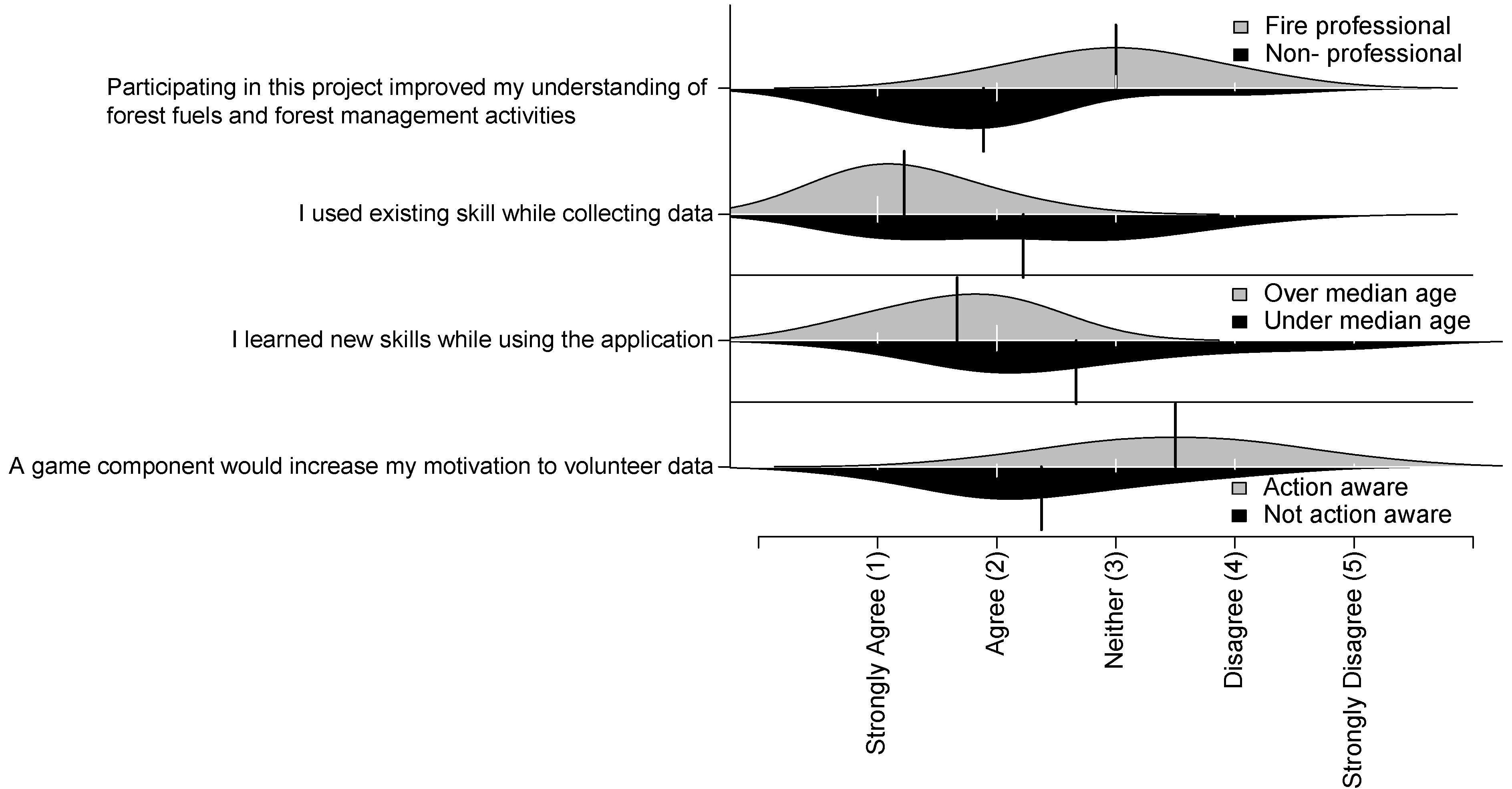
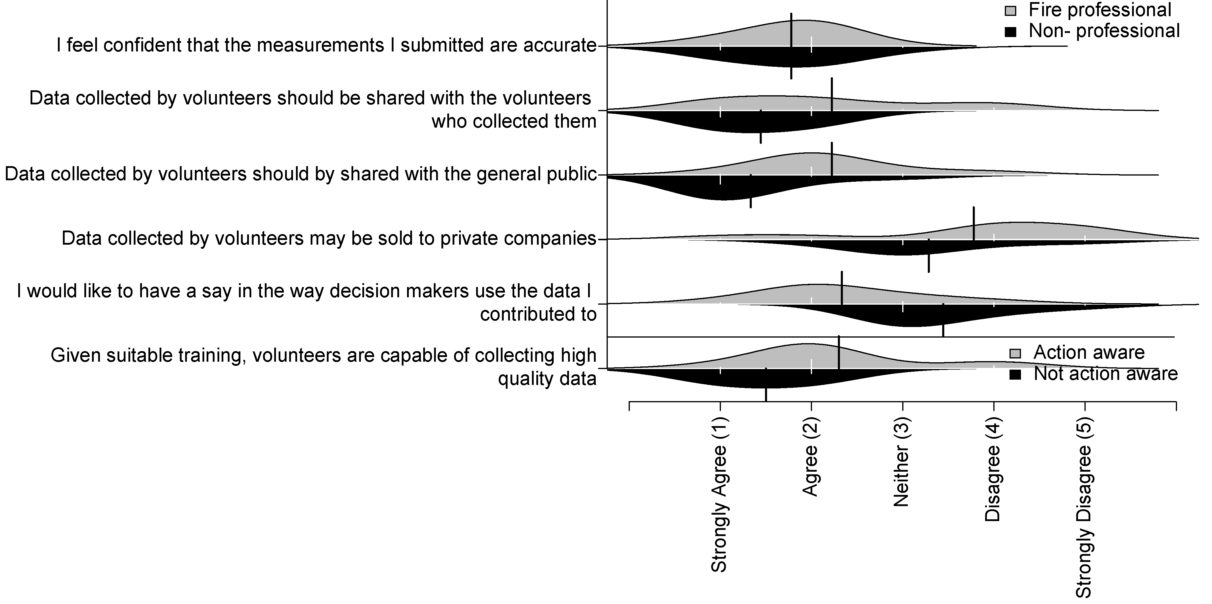
27]. In this study, participation in data collection was voluntary, and despite extensive efforts to recruit participants without professional experience related to wildfire (for whom the application was designed), half of the participants had professional backgrounds in wildfire. Although the professional involvement was not intended or expected to be as large, it represents a willingness by professionals to engage with the community about wildfire topics and provides insights into the ways that professionals and non-professionals approach similar tasks. Professional participants had higher career related motivations for their involvement, indicated higher previous knowledge and skills related to measuring forest fuels, and wanted more input in how the data are used. On many other topics, forest professionals answered questions in a similar way as non-professional participants, demonstrating many shared values with other people in the community. Our initial experience suggests that substantial professional involvement may be beneficial or necessary in a wildfire PPSR project to address and mitigate some of the inherent risks related to wildfire management and also as a public outreach opportunity.
Motivation to volunteer is critical to the success of PPSR projects and also for public outreach projects for wildfire protection. The number of participants in this study was lower than expected, especially considering the generally positive reception of the research by the community and local media coverage that occurred during the recruiting campaign. One factor was that the research team was located in a different city than the field site, restricting the number of scheduled visits. If the research team were closer to the study site, several more potential participants’ schedules could have been accommodated. In other efforts, such as volunteer mapping of streets, a small number of volunteers have been able to thoroughly map areas and provide very high quality data, especially if those volunteers are motivated to accurately represent an area, and the products developed from the volunteered data are distributed to a much broader audience [28]. Despite the small sample size in the present project, the number of participants was realistic for a community-mapping project. In future research, sharing the volunteered data over the internet and inviting participation in other ways, such as viewing or analyzing the collected data, could attract a potentially larger group of people.
Non-professional respondents’ awareness of other existing public outreach wildfire programs (such as Partners-in-Protection) was surprisingly low, considering that they are the target audience of the programs. In contrast to many other PPSR projects that are targeted to hobbies (such as birdwatching or astronomy), this study dealt with preparatory actions to avoid a hazard. As such, there are differences in the implementation from an organizational and participant perspective. Other volunteer projects have addressed risk-related issues with considerable recruitment of volunteers, however most have dealt with responses to disaster situations and not prevention [19,29]. Likewise, for wildfire hazard reduction, salience for wildfire issues is highest soon after the occurrence of a wildfire [6]. Smartphone applications and public participation data collection projects may serve a different role in wildland fire management. For example, long-term interactions are also important for positive citizen-agency relationship building [7]. Similar to how the experiment in the present study was structured, in a PPSR inspired project, community foresters may interact with participants on an ongoing basis in person, at workshops, and through electronic communications thus providing an environment to build citizen-agency relationships, and potentially increase knowledge over a longer time period.
The retention of citizen volunteers is another factor that is critical to the success of PPSR projects. Some PPSR projects have utilized game elements and social network services in an effort to increase motivation and engagement for collecting data (e.g., Han et al. [30]). Volunteers in other PPSR projects have indicated that game elements and electronic communication tools that provided social interaction and recognition of achievements were important for the ongoing involvement of volunteers in projects, but were not a factor in recruitment [31]. In addition, factors related to understanding were the most frequently reported motivations in the Galaxy Zoo project, an astronomy project where volunteers classified the shape of galaxies in images acquired by the Hubble telescope, with a strong following of an estimated 20,000 volunteers (sample of 20 volunteers) [32]. Our exploratory research suggests that the factors identified after using the application (understanding, social, and values) could be further developed to retain volunteers in PPSR projects related to wildfire. Electronic communication tools can be easily incorporated into the application to support the retention of volunteers through social incentives, and in addition provide opportunities for interactive communication with fire managers.
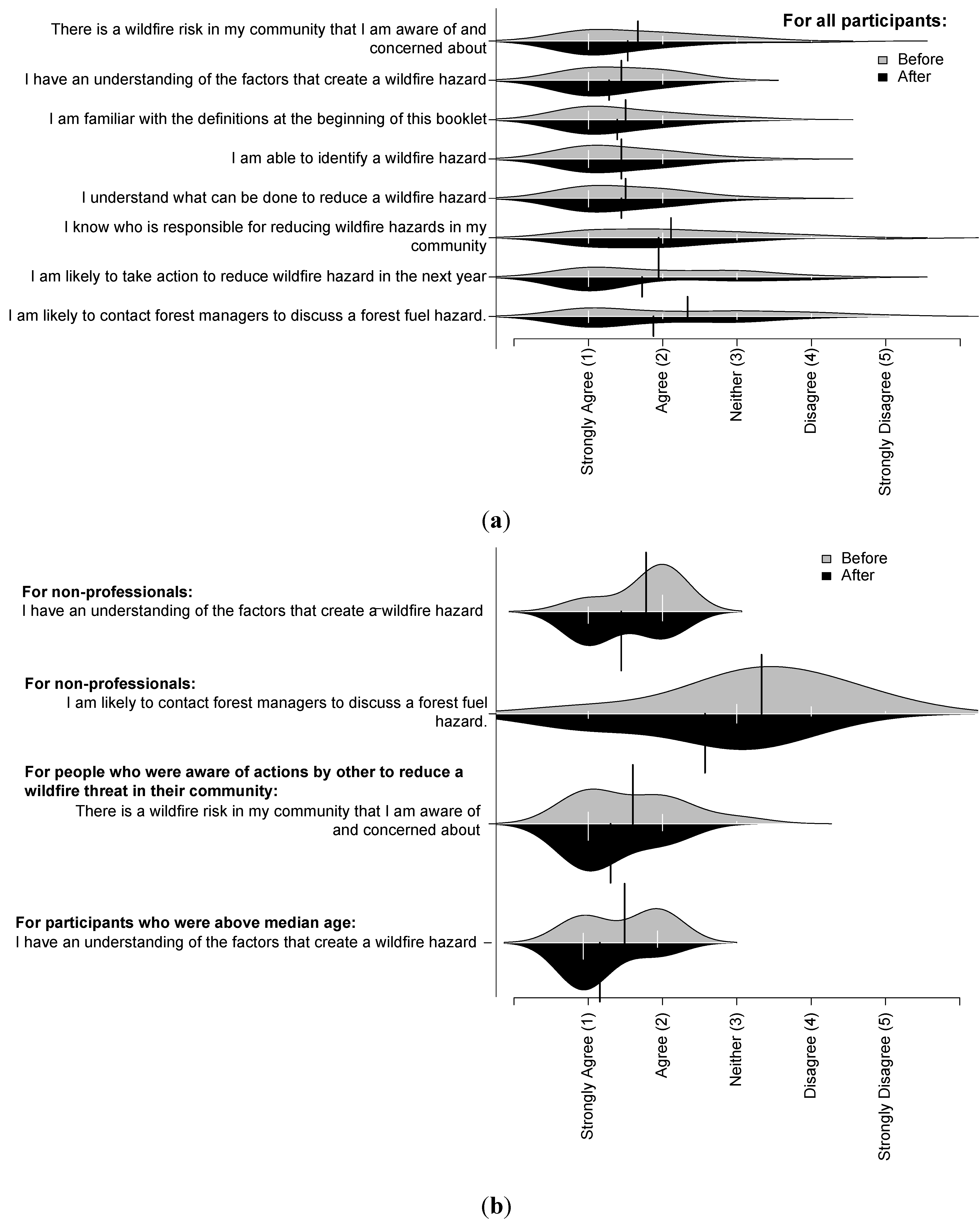
Previous research linked perceived risk and threat assessment with homeowners taking wildfire mitigation action [33]. Therefore, increased perceived risk and improved threat assessment are desirable outcomes for this project. The changes observed in the repeated questions related to awareness of forest fuel hazards, knowledge about forest fuels, and planned behaviors for forest fuels hazard reduction after using the application to collect forest fuels data were small in magnitude. These changes were small, likely in part because most of the participants had already agreed or strongly agreed with most of the statements prior to using the application to collect forest fuels data, leaving little room for improvement and many of the participants were already aware of fire hazards and motivated to take action as indicated through volunteering for the project. In addition, the participants used the application for a short amount of time and did not have the opportunity to use the application more than once. Price and Lee [34] found an increase in scientific literacy along with a negative change in personal evaluations of knowledge over a six-month astronomy project, which they attributed to participants gaining a greater appreciation for what they had yet to learn. Nonetheless, our exploratory findings indicate that there is promise to use PPSR as a tool with the potential for positive outcomes for the participants and for communities where wildfires occur.
While using the application, some of the participants raised considerations that need to be addressed before the application could be released to the public. First, operational uses and restrictions would need to be defined, for example, if different procedures are required to use the application on public lands with data sharing, or if usage on private lands would necessitate data being held in confidence. The second consideration was risk or liability associated with wildfire. For example, could the project organizers be held liable for damages if volunteered assessments lead to the decision not to treat an area and a wildfire occurred? Alternatively, if the assessments indicated that a treatment should be performed but were not financially possible, would the responsible person or organization be held liable for damage caused by the fire? Careful legal consultation would be needed in any region where the application was released to the public. Third, a concern was raised about adversarial or malicious measurements. For example, a participant cited an example of one resident illegally cutting trees to improve his view under the guise of fuel reduction; however, any indication of this type of behavior was not observed in this study. The images collected by the application would provide evidence that could be reviewed against any inflated claims, and observations from the same area conducted by different, independent observers could provide further corroborating evidence. In the study region, municipal bylaws restrict the removal of large trees without permitting. Finally, a concern was raised about rapidly distributing data without professional interpretation, leading to unreasonable public pressure on community foresters to perform treatments that are beyond operating budgets or do not match priorities. In the an ideal case, PPSR inspired projects may provide a mechanism to share information about forest management decisions and build participant knowledge, including tradeoffs, costs, and compromises in making decisions, which are activities that are associated with increased support and trust for agencies making forest management decisions [12]. All forest professionals indicated that they would like to be consulted about how the data were used, which is reasonable given their expertise, in prescribing treatments to improve safety and maintain forest health. It is unknown whether moderation or filtering of the data by professionals would affect the motivation of participants and how this would affect the perception of the project and agencies involved in the project. In addition, if participants feel that agencies do not recognize or use information that they receive from interactions with the public, it may erode trust in the agency [35], which is a potential risk for agencies engaging in PPSR inspired wildland fire projects. In future work, systems will be needed to store and analyze the data, and the previously mentioned expectations of fairness of use of the data may provide guidance in developing approaches for data stewardship [36].

4.1. Limitations of Study

This was an exploratory study, conducted under controlled conditions in a limited area and over a short time period. Conducting the study with more participants, over a broader area, and over a longer time period would provide more robust information. Statistical methods were used only to explore the data, and larger sample sizes and more controlled experiments would be needed to make inferences about larger populations. This study was not intended as an inferential study, but a proof of concept of a new application. More work is needed to assess if this smartphone application would see market success and uptake.

5. Conclusions

Forest fuels treatment in the WUI is important to reduce the threat of wildfire to communities. This exploratory study applied a PPSR approach to forest fuels treatment in the WUI using a smartphone application to collect forest structural data related to forest fuel loading. This study applied PPSR approaches to wildfire management with the intent of communities and volunteers experiencing positive outcomes while building a more extensive dataset of fuel loading data. Through answers to questionnaires, we evaluated the relationship of demographics and experiences of participants to their awareness, knowledge, and planned behaviors related to wildfire and considered how these might be addressed in a technology-driven PPSR project. In addition, several logistical considerations were identified that should be addressed before this approach is implemented outside of an experimental setting.
Measuring forest fuels data is usually in the domain of forest professionals. Our approach differs in that we invited non-professionals to engage in this activity using a smartphone application to facilitate data collection. Because wildfire threatens large populations, the outcomes of PPSR-based approaches have the potential to benefit large numbers of people and provide a mechanism for community members to take positive preventative action. Approaches inspired by PPSR are another outreach tool available to forest managers with the potential for positive outcomes in WUI communities. However, some of the differing answers between professionals and non-professionals indicate a need for caution in utilizing these new approaches. Initially, forest managers may wish to engage more limited levels of participation, for example, rather than distributing the application widely to the general public, the application could be given to smaller groups who have received training. Issues such as legal liability associated with the use of data collected using this application would also require ongoing attention and refinement over time.
In future work, this approach could be released for use with a greater number of people and throughout a broader area. The approach can be expanded to include more possibilities offered by the technology, including extensive feedback (such as maps of the data collected), social connectedness, and implementation for broader objectives including conservation. This project focused on the data collection aspect of a PPSR inspired project, so future work may test other types of participation in wildland fire management, for example, setting study objectives, analyzing data, weighing costs and benefits in decision making, and distributing the results to a broader audience.

Acknowledgments

First, the authors would like to thank each of the participants for sharing their time, effort, feedback, and insights. We hope that your efforts will lead to wildfire hazard reduction in Kelowna and in other wildfire-affected communities. We would like to thank John Davies, Andrew Hunsberger, and Jordan Carter of Valhalla Consulting for their guidance and assistance developing the application. We would like to thank Raphael Roy-Jauvin for his help in development of the application and in field testing. We would like to thank John Arnett, Vanessa Mascorro, Wiebe Nijland, and Doug Bolton for their help in field testing and meeting participants. Thank you to the anonymous peer reviewers for their comments. The work was funded by an NSERC Discovery grants to Coops and Engage to Ferster. This research was approved under UBC ethics application H12-00257.

Conflicts of Interest

The authors declare no conflict of interest.

References

  1. Radeloff, V.C.; Hammer, R.B.; Stewart, S.I.; Fried, J.S.; Holcomb, S.S.; McKeefry, J.F. The wildland-urban interface in the United States. Ecol. Appl. 2005, 15, 799–805. [Google Scholar] [CrossRef]
  2. Agee, J.K.; Skinner, C.N. Basic principles of forest fuel reduction treatments. For. Ecol. Manag. 2005, 211, 83–96. [Google Scholar] [CrossRef]
  3. Keane, R.E.; Burgan, R.; van Wagtendonk, J.W. Mapping wildland fuels for fire management across multiple scales: Integrating remote sensing, GIS, and biophysical modeling. Int. J. Wildland Fire 2001, 10, 301–319. [Google Scholar] [CrossRef]
  4. Cohen, J. Preventing disaster: Home ignitability in the wildland-urban interface. J. For. 2000, 98, 15–21. [Google Scholar]
  5. Partners-in-Protection. FireSmart manual for homeowners. Available online: http://www.embc.gov.bc.ca/ofc/interface/pdf/homeowner-firesmart.pdf (Accessed on 27 March 2013).
  6. Monroe, M.; Pennisi, L.; McCaffry, S.; Mileti, D. Social Science to Improve Fuels Management: A Synthesis of Research Relevant to Communicating with Homeowners about Fuels Management; General Technical Report NC-267; US Department of Agriculture Forest Service, North Central Research Station: St. Paul, MA, USA, 2006.
  7. Olsen, C.S.; Shindler, B.A. Trust, acceptance, and citizen-agency interactions after large fires: Influences on planning processes. Int. J. Wildland Fire 2010, 19, 137–147. [Google Scholar] [CrossRef]
  8. Shirk, J.L.; Ballard, H.L.; Wilderman, C.C.; Phillips, T.; Wiggins, A.; Jordan, R.; McCallie, E.; Minarchek, M.; Lewenstein, B.V.; Krasny, M.E.; et al. Public participation in scientific research: A framework for deliberate design. Ecol. Soc. 2012, 17, 29. [Google Scholar]
  9. Cooper, C.B.; Dickinson, J.; Phillips, T.; Bonney, R. Citizen science as a tool for conservation in residential ecosystems. Ecol. Soc. 2007, 12, 11. [Google Scholar]
  10. Bonney, R.; Dhondt, A. FeederWatch: An Example of Student-Scientist Partnership. In Internet Links for Science Education: Student—Scientist Partnerships; Cohen, K.C., Ed.; Plenum Press: New York, NY, USA, 1997; pp. 31–53. [Google Scholar]
  11. Sullivan, B.L.; Wood, C.L.; Iliff, M.J.; Bonney, R.E.; Fink, D.; Kelling, S. eBird: A citizen-based bird observation network in the biological sciences. Biol. Conserv. 2009, 142, 2282–2292. [Google Scholar] [CrossRef]
  12. Parkinson, T.; Force, J.; Smith, J. Hands on learning: Its effectiveness in teaching the public about wildland fire. J. For. 2003, 101, 21–26. [Google Scholar]
  13. Toman, E.; Shindler, B.; Brunson, M. Fire and fuel management communication strategies: Citizen evaluations of agency outreach activities. Soc. Nat. Resour. 2006, 19, 321–336. [Google Scholar] [CrossRef]
  14. Ferster, C.; Coops, N. A review of earth observation using mobile personal communication devices. Comput. Geosci. 2012, 51, 339–349. [Google Scholar] [CrossRef]
  15. Lane, N.; Miluzzo, E.; Lu, H.; Peebles, D.; Choudhury, T.; Campbell, A. A survey of mobile phone sensing. IEEE Commun. Mag. 2010, 48, 140–150. [Google Scholar]
  16. Powell, J.; Nash, G.; Bell, P. GeoExposures: Documenting temporary geological exposures in great britain through a citizen-science web site. Proc. Geol. Assoc. 2012, 124, 638–647. [Google Scholar] [CrossRef]
  17. Weng, Y.-H.; Sun, F.-S.; Grigsby, J.D. GeoTools: An android phone application in geology. Comput. Geosci. 2012, 44, 24–30. [Google Scholar] [CrossRef]
  18. Pratihast, A.K.; Herold, M.; Avitabile, V.; de Bruin, S.; Bartholomeus, H.; Souza, C.M.; Ribbe, L. Mobile devices for community-based REDD+ monitoring: A case study for central vietnam. Sensors 2012, 13, 21–38. [Google Scholar] [CrossRef]
  19. Cross, R. Wildfire Apps for iPhone and Android. 2013. Available online: http://www.redcross.org/mobile-apps/wildfire-app (Accessed on 20 June 2013).
  20. Moskell, C.; Allred, S.B.; Ferenz, G. Examining motivations and recruitment strategies for urban forestry volunteers. Cities Environ. 2010, 3, 1–28. [Google Scholar]
  21. Clary, E.G.; Snyder, M.; Ridge, R.D.; Copeland, J.; Stukas, A.A.; Haugen, J.; Miene, P. Understanding and assessing the motivations of volunteers: A functional approach. J. Pers. Soc. Psychol. 1998, 74, 1516–1530. [Google Scholar] [CrossRef]
  22. Sikkink, P.G.; Keane, R.E. A comparison of five sampling techniques to estimate surface fuel loading in montane forests. Int. J. Wildland Fire 2008, 17, 363–379. [Google Scholar] [CrossRef]
  23. Morrow, B.; Johnston, K.; Davies, J. Rating Interface Wildfire Threats in British Columbia; BC Ministry of Forests and Range Protection Branch: Victoria, BC, Canada, 2008.
  24. Cooper, C.B.; Dickinson, J.L.; Phillips, T.; Bonney, R. Science explicitly for nonscientists. Ecol. Soc. 2008, 13, r1. [Google Scholar]
  25. Sauer, J.; Link, W.; Nichols, J.; Royle, J. Using the North American Breeding Bird Survey as a tool for conservation: A critique of Bart et al. (2004). J. Wildl. Manag. 2005, 69, 1321–1326. [Google Scholar] [CrossRef]
  26. Dickinson, J.L.; Zuckerberg, B.; Bonter, D.N. Citizen science as an ecological research tool: Challenges and benefits. Annu. Rev. Ecol. Evol. Syst. 2010, 41, 149–172. [Google Scholar] [CrossRef]
  27. Brabham, D.C. The myth of amatuer crowds. Inf. Commun. Soc. 2012, 15, 394–410. [Google Scholar] [CrossRef]
  28. Haklay, M.; Basiouka, S.; Antoniou, V.; Ather, A. How many volunteers does it take to map an area well? The validity of linus’ law to volunteered geographic information. Cartogr. J. 2010, 47, 315–322. [Google Scholar] [CrossRef]
  29. Meier, P. Crisis mapping in action: How open source software and global volunteer networks are changing the world, one map at a time. J. Map Geogr. Libr. 2012, 8, 89–100. [Google Scholar] [CrossRef]
  30. Han, K.; Graham, E.A.; Vassallo, D.; Estrin, D. Enhancing Motivation in a Mobile Participatory Sensing Project through Gaming. In Proceedings of 2011 IEEE Third International Conference on Privacy, Security, Risk and Trust and 2011 IEEE Third International Conference on Social Computing, Boston, MA, USA, 9–11 October 2011; pp. 1443–1448.
  31. Iacovides, I.; Jennett, C.; Cornish-Trestrail, C.; Cox, A.L. Do Games Attract or Sustain Engagement in Citizen Science? In Proceedings of CHI EA ’13 Extended Abstracts on Human Factors in Computing Systems on-CHI EA ’13, Paris, France, 27 April–2 May 2013; pp. 1101–1106.
  32. Raddick, M.J.; Bracey, G.; Gay, P.L.; Lintott, C.J.; Murray, P.; Schawinski, K.; Szalay, A.S.; Vandenberg, J. Galaxy zoo: Exploring the motivations of citizen science volunteers. Astron. Educ. Rev. 2010, 9, 010103. [Google Scholar] [CrossRef]
  33. McFarlane, B.L.; McGee, T.K.; Faulkner, H. Complexity of homeowner wildfire risk mitigation: An integration of hazard theories. Int. J. Wildland Fire 2011, 20, 921–931. [Google Scholar] [CrossRef]
  34. Price, C.A.; Lee, H.-S. Changes in participants’ scientific attitudes and epistemological beliefs during an astronomical citizen science project. J. Res. Sci. Teach. 2013, 50, 773–801. [Google Scholar] [CrossRef]
  35. Shindler, B.A.; Toman, E.; McCaffrey, S.M. Public perspectives of fire, fuels and the Forest Service in the Great Lakes Region: A survey of citizen-agency communication and trust. Int. J. Wildland Fire 2009, 18, 157–164. [Google Scholar] [CrossRef]
  36. Michener, W.K.; Jones, M.B. Ecoinformatics: Supporting ecology as a data-intensive science. Trends Ecol. Evol. 2012, 27, 85–93. [Google Scholar] [CrossRef]

