
Fire Regime Characteristics along Environmental Gradients in Spain


Environmental Remote Sensing Research Group, Department of Geology, Geography and Environment, University of Alcala, Colegios 2, 28801 Alcalá de Henares, Spain
*
Author to whom correspondence should be addressed.
Forests 2016, 7(11), 262; https://doi.org/10.3390/f7110262
Submission received: 26 June 2016
/
Revised: 28 October 2016
/
Accepted: 1 November 2016
/
Published: 4 November 2016
(This article belongs to the Special Issue Fire Regimes: Spatial and Temporal Variability and Their Effects on Forests)
Abstract
:Concern regarding global change has increased the need to understand the relationship between fire regime characteristics and the environment. Pyrogeographical theory suggests that fire regimes are constrained by climate, vegetation and fire ignition processes, but it is not obvious how fire regime characteristics are related to those factors. We used a three-matrix approach with a multivariate statistical methodology that combined an ordination method and fourth-corner analysis for hypothesis testing to investigate the relationship between fire regime characteristics and environmental gradients across Spain. Our results suggest that fire regime characteristics (i.e., density and seasonality of fire activity) are constrained primarily by direct gradients based on climate, population, and resource gradients based on forest potential productivity. Our results can be used to establish a predictive model for how fire regimes emerge in order to support fire management, particularly as global environmental changes impact fire regime characteristics.
Keywords:
fire density; fire ecology; fire management; fire seasonality; fourth-corner; RLQ; pyrogeography1. Introduction
Fire regimes play an important role in many terrestrial ecosystems [1,2,3], and changes in fire regime characteristics affect the structure and composition of vegetation, which in turn might affect different ecosystem characteristics, such as biodiversity [1,2]. Several authors have reported changes in fire regime characteristics, such as fire density (i.e., the number of fires per unit area) and seasonality (the period of the year during which fires occur) as a result of climate warming [4] and demographic factors [5,6,7,8]. Others have shown that humans now influence fire activity in areas where climate has been the main historical driving force such as in some tropical [9] or boreal regions [10,11]. Regional studies have emphasised the role of humans in future fire regimes, such as in Africa [7], but climate has a stronger role at the global scale [12]. To predict the potential effect of global environmental change on future fire regimes, we must therefore understand the relationship between fire regime characteristics and the environment, particularly how both climate [12,13] and socio-economic factors [8,14,15,16] interact with fire ignition and fuel accumulation processes.
Pyrogeographical theory suggests that fire regimes are structured by spatial gradients of climate, vegetation and ignitions, which constrain fuel flammability, fuel loading and ignition sources [13,17,18,19]. However, such relationships are complex because of their feedback and interactions, and some of them remains unclear [17,20,21]. For example, climate is a major driver of fire activity, while fire activity influences climate by emitting carbon dioxide (CO2) and by causing changes to land albedo.
Meyn et al. [22] proposed a pyrogeographical model based on the premise that fire activity varies across fuel loading and fuel moisture gradients. This theory was later supported by Batllori et al. [23], who studied Mediterranean ecosystems. Similarly, Pausas et al. [24] emphasised the role of a productivity gradient in the Mediterranean ecosystem in south-east Australia and Spain. Krawchuk and Moritz [21] and Pausas and Ribeiro [25] identified a resource gradient at the global scale. At a global scale, Chuvieco et al. [26] observed a diversity of fire regimes, and Archibald et al. [27] emphasised the presence of different fire regimes in various biomes.
In Spain, the current understanding of the relationships between fire regime and environmental characteristics is based on studies that have been carried out at local or regional levels, and there is a limited understanding of how those relationships vary regionally. La Page et al. [5] related fire seasonality to human activities in northern Spain. Pausas and Paula [28] emphasised the role of fuel in fire-climate relationships and suggested that the vegetation structure controls the fire and climate relationship using data for the whole country of Spain except Basque Country and Navarra. However, Pausas and Fernández-Muñoz [29] suggested that climate currently has a greater effect on fire regimes than fuel in the province of Valencia on the Mediterranean Coast of Spain. Moreover, Moreno et al. [30] demonstrated that changes in the number of fires and burned areas in three Spanish regions over two seasons coincided with changes in weather, land use and fire management, thus indicating different regional and seasonal roles.
To gain a better understanding of environmental gradients that constraint fire regime characteristics from a regional perspective, we examined the spatial structure of fire regimes and environmental gradients and tested for significant relationships between them. In addition, we propose a methodological approach that could be used for other regional or global studies. This paper presents the main structure of fire regime characteristics, density and seasonality of fire activity, and environmental gradients in Spain as well as the statistical significance of the associations.
2. Materials and Methods
2.1. Study Area
The study area includes the Spanish territory of the Iberian peninsula, divided in a 10 km × 10 km Universal Transverse Mercator (UTM) grid, which covers a surface area of 466,614 km2 (Figure 1).
The average annual temperature ranges between 3–19 °C, showing a general decrease from west/northwest to east/southeast, and an average annual precipitation between 213–1348 mm, showing a general increase from east/southeast to west/northwest. The northwest is characterized by mild winters and warm summers and abundant precipitations over the year. The west is characterized by cool and wet winters, and warm and dry summers. The east is characterized by mild winters and warm and dry summers. The southeast is characterized by mild winters and very warm and dry summers.
The crisis in traditional agriculture in the 1960s caused a massive immigration from rural areas to medium and large cities, resulting in an increase of population densities in the main industrial cores and along the coast, as a result of the touristic attraction. Furthermore, the abandonment of marginal areas and traditional grazing practices led to natural afforestation of previously cultivated areas, and consequently an increase in the accumulation of fuel [30].
2.2. Fire Regime Groups and Fire Regime Characteristics
We used a fire regime classification system developed by Moreno and Chuvieco [32] using the data of all fires that burned ≥1 ha, regardless of the ignition source, from the Spanish General Statistics of Forest Fires (EGIF) database from 1988–2007 and georeferenced to a 10 km × 10 km UTM grid.
Using a statistical approach, Moreno and Chuvieco [32] computed six fire regime metrics, density (number of fires or ha per km2 per year), interannual variability (standard deviation of density) and seasonality (the number of months with significant density) as a function of both the number of fires and the burned area. These six fire regime metrics were analysed using Principal Component Analysis (PCA). The first PCA axis was related to both the density and interannual variability of the number of fires and burned areas (loadings ≥ 0.75), whereas the second PCA axis was related to the seasonality of the number of fires and burned areas (loadings ≥ 0.69), where both axes were more strongly related to the burned area than to the number of fires. For further analysis, the first PCA axis was considered as the density of fire activity and the second PCA axis as the seasonality of fire activity. Finally, the two PCA axes were used in a cluster analysis to generate fire regime groups.
The resulting fire regime classification system [32] included the presence of four fire regime groups defined by two fire regime characteristics, density, and seasonality of fire activity (Table 1), which were partitioned into two respective states, high and low density, and long and short seasonality. For example, a fire regime group characterised by a high density and long seasonality indicated that both the density of fires (number of fires per km2 per year) and the burned areas (ha per km2 per year) were high and also that the number of months with significant density in terms of the number of fires and burned areas was large.
2.3. Environmental Gradients
Based on pyrogeographical theory [13,17,18,19] and considering fires as a ‘herbivore’ according to some authors [2,33], we expected that fire regime characteristics would change along three types of environmental gradients (Table 2): (i) direct gradients based on climate and humans because both affect fuel flammability and fire ignition processes; (ii) resource gradients based on forest potential productivity and land cover because fuel is consumed by fires; and (iii) indirect gradients based on livestock grazing and land cover changes from afforestation, forest degradation and the abandonment of traditional activities, which indirectly affect ignition, structure and the amount of fuel [34].
Our direct gradients were based on climate and humans as measured by three indicators: (i) a measure of humidity, which was calculated as the ratio of the average annual precipitation and the average annual temperature [35]; (ii) a seasonal temperature fluctuation, which was calculated as the difference between the average temperature of the coldest and warmest months [35]; and (iii) human population pressure, as measured by population density (inhabitants/km2). Meteorological data were obtained from the Digital Climatic Atlas of Spain [31], and population data were obtained from the National Cartographic Base (BCN200) established by the National Geographic Institute.
Our resource gradients were based on forest potential productivity, which is defined on a scale ranging from 1–7 as the original source does, in which 1 was most productive and 7 was least productive, and land cover, which was defined by six categories: needle-leaf trees, broadleaf trees, mixed trees, shrubs, herbaceous vegetation and cultivated and managed vegetation/agriculture (including mixtures). The forest potential productivity data were obtained from the Forest Potential Productivity map of Spain defined using climate and soil data [36]. The land cover data were obtained from the 2000 Corine Land Cover map compiled by the National Geographic Institute, which were reclassified into broader categories using a simplified legend [37,38].
Our indirect gradients were based on livestock grazing, which was defined by livestock density (cattle, sheep and goats per km2), and land cover changes defined by the following three changes: (i) land cover changes to forests: from cultivated and managed vegetation/agriculture (including mixtures), herbaceous vegetation and shrubs or barren to needle-leaf trees, broadleaf trees and mixed/other trees; (ii) land cover changes to shrubs: from needle-leaf trees, broadleaf trees and mixed/other trees to shrubs or barren; and (iii) land cover changes from managed: from cultivated and managed vegetation/agriculture (including mixtures) to needle-leaf trees, broadleaf trees, mixed/other trees, shrubs or barren and herbaceous vegetation. The livestock data were obtained from the 2001 rural census compiled by the National Statistics Institute. The land cover change data were obtained from the Corine Land Cover Change map from 1990–2000 compiled by the National Geographic Institute, which was reclassified into categories using the identical generalized legend used for land cover.
All of the data layers were projected as a UTM Zone 30 and the European Datum 1950 (ED50) using a 10 km × 10 km grid, which is the standard grid used to compile fire statistics by the Spanish forest service. The climate data were resampled from 1 km × 1 km by assigning the average of the 1 km × 1 km values to each 10 km × 10 km cell. For the forest potential productivity, land cover and land cover change characteristics, we computed the proportion of each class within a 10 km × 10 km cell. The population and livestock data were resampled from a municipal level to grid size as a function of the proportion of area of each municipality into each cell.
2.4. RLQ Analysis
An RLQ analysis is a three-matrix ordination approach proposed by Dolédec et al. [39] based on a fourth-corner matrix D (m × q), which describes the fire regime characteristics-environment relationship (Figure 2). Matrix L (p × n) describes the presence or absence of the p = 4 fire regime groups at n = 4652 sites. Each n site corresponds with each cell from the 10 km × 10 km UTM grid. Matrix Q (p × q) describes the q = 2 fire regime characteristics for each p fire regime groups. Matrix R (m × n) describes the m = 20 environment characteristics for each n site.
An ordination method was applied to the RLQ matrices to identify the main structure of variation. To understand how fire regime groups are organized, correspondence analysis (CA) was applied to the fire regime groups (Matrix L) because it is suitable for presence-absence data and dimensionally homogeneous and positive values [40]. Multiple correspondence analysis (MCA) was applied to the fire regime characteristics (Matrix Q) with CA fire regime group weights to study the fire regime characteristics because that ordination method is suitable for qualitative data [40]. Principal Component Analysis (PCA) was applied to the environmental characteristics (Matrix R), previously transformed using a logarithmic transformation to ensure a multi-normal distribution, with CA site weights because PCA is required to study quantitative data [40].
2.5. Fourth-Corner Analysis
A fourth-corner analysis is also a three-matrix approach, proposed by Legendre et al. [41], and was used to test the fire regime characteristics-environment relationship, corresponding to matrix D.
The measurement of resemblance between the standardized quantitative characteristics and the standardized qualitative characteristics recoded into binary variables was based on Pearson’s r [41].
Statistical significance was tested by 9999 permutations using model 2, proposed by Legendre et al. [41]. Model 2 tested for significant differences under the null hypothesis (H0), a random distribution of the fire regime groups among the sites, vs. an alternative hypothesis (H1), a non-random distribution of the fire regime groups among the sites. This comparison was based on the premise that fire regime groups are observed at sites where their characteristics are constrained by environmental gradients. The model permuted entire rows of matrix L, which was equivalent to permuting the rows of matrix R and maintaining co-inertia among the fire regime groups and the link to matrix Q. The significance level was adjusted using the false discovery rate method proposed by Benjamini and Hochberg [42] for multiple testing. We used model 2 because the link between fire regime groups (Matrix L) and fire regime characteristics (Matrix Q) was fixed in our data. Therefore, the combination of the two permutation models, which better controls the Type I error, as proposed by Dray and Legendre [43] and improved by ter Braak et al. [44], was not suitable for our data.
2.6. Combining RLQ and Fourth-CornerAnalyses
The RLQ and four-corner analyses were combined by adapting the framework proposed by Dray et al. [45]. First, a global multivariate test of statistical significance between the fire regime (Matrix Q) and environmental characteristics (Matrix R) and the fire regime groups (Matrix L) based on the total co-inertia of the RLQ analysis was tested using 9999 permutations of entire rows of matrix L. This analysis tested for significant differences under the null hypothesis (H0) of independence of fire regime characteristics among environmental gradients vs. an alternative hypothesis (H1) of non-independence. This comparison was based on the premise that fire regime characteristics are constrained by environmental gradients. The Monte Carlo method was used, which is equivalent to SRLQ proposed by Dray and Legendre [43].
RLQ and fourth-corner analyses were then combined by performing a fourth-corner analysis on the main axis that resulted from the RLQ analysis.
All analyses were computed with the statistical RStudio software using the ade4 package version 1.5-2 [46].
3. Results
3.1. Global Multivariate Statistic
The null hypothesis of the global multivariate statistic based on the total co-inertia of the RLQ analysis is that fire regime and environmental characteristics are independent, and because the result was highly significant (p-value = 0.0001), we can conclude that there is a global relationship between fire regime characteristics (Matrix Q) and environmental characteristics (Matrix R) based on the fire regime groups (Matrix L).
3.2. Decomposition of Inertia
The results of the RLQ analysis, summarized in Table 3, show that the first RLQ axis represented 96% and the second RLQ axis 4% of the total co-inertia between the fire regime characteristics and the environment. The inertia of the environmental scores was well preserved on the first two RLQ axes, 86%, and the total inertia of the fire regime characteristics was 100%. However, the correlation was low for the second RLQ axis, 0.13.
3.3. Fire Regime Characteristics-Environmental Structures and Relationships
The null hypothesis of model 2 states that fire regime groups are randomly distributed across the study area, and because we can reject the null hypothesis, we can conclude that the fire regime groups were not randomly distributed across the sites. This indicates that fire regime groups were observed at sites where fire regime characteristics were constrained by environmental gradients.
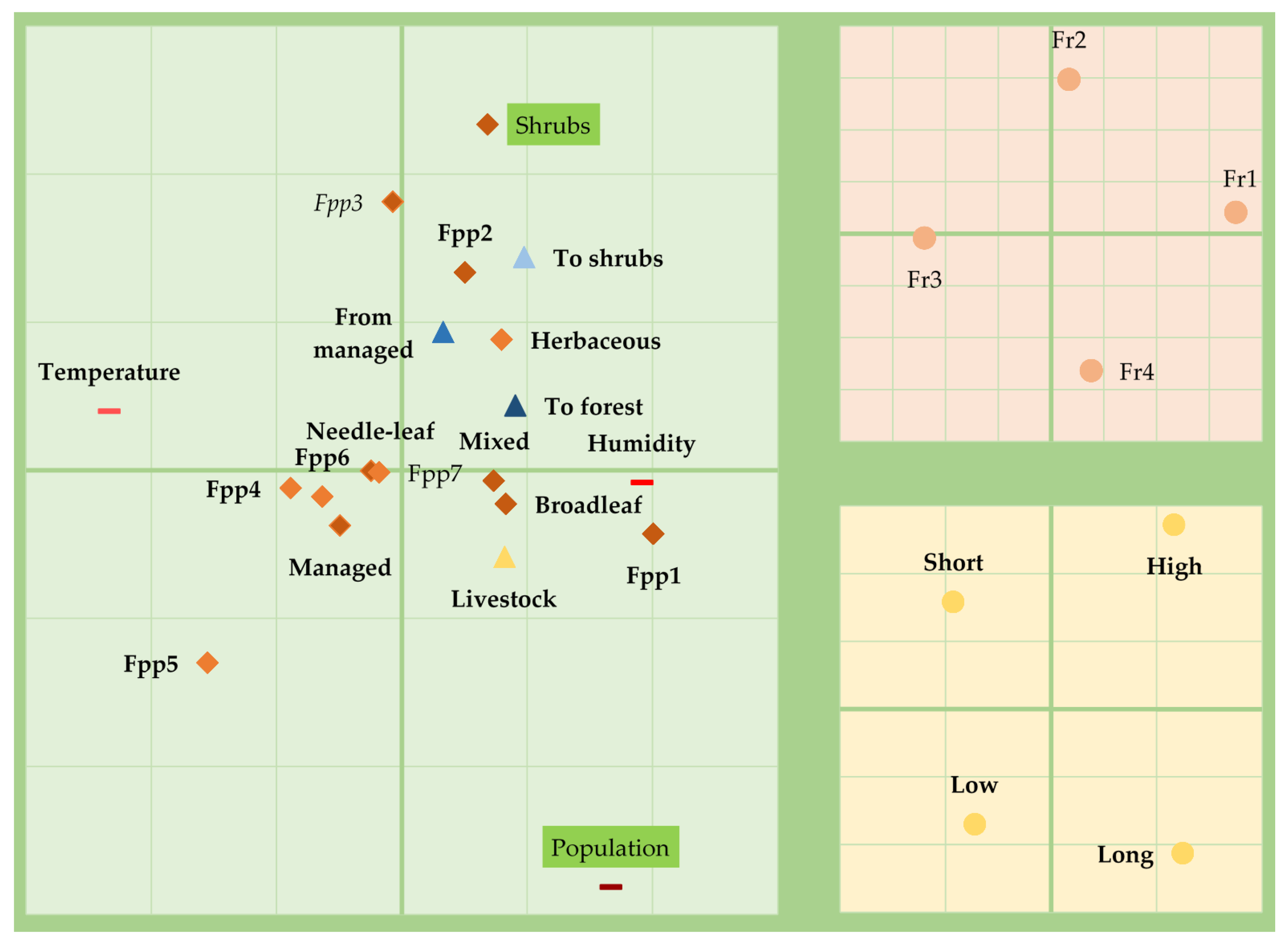
The structure of fire regime characteristics, shown in Figure 3, changed along a complex environmental gradient represented by the first and second RLQ axes.
The first RLQ axis identifies and is significantly positively correlated with high density and long seasonality of fire activity (fire regime 1) at sites defined by humidity, density of population, high forest potential productivity (categories 1–2), broadleaf trees, mixed trees, shrubs and herbaceous land covers, density of livestock and land cover changes and negatively correlated with low density and short seasonality of fire activity (fire regime 2) at sites defined by seasonal temperature fluctuation, low forest potential productivity (categories 3–7), as well as by needle-leaf trees and managed land covers.
The second RLQ axis identifies and is significantly positively correlated with high density and short seasonality of fire activity (fire regime 2) at sites defined by medium forest potential productivity (category 3) and shrubs and negatively correlated with low density and long seasonality of fire activity (fire regime 4) at sites defined by density of population.
4. Discussion
Our results indicate that the selected fire regime characteristics, namely density and seasonality of fire activity, responded to environmental gradients, thus suggesting that fire regimes are spatially structured. Density and seasonality of fire activity changed along environmental gradients, as expected, and were structured primarily by direct and resource gradients and secondarily by indirect gradients, suggesting that climate, humans and forest potential productivity have an important role in the fire regime characteristics, constraining flammability and the amount of fuel and ignitions.
The first RLQ axis positively identified fire regime 1 with high density and long seasonality of fire activity at sites defined by humidity, but negatively identified fire regime 3 with low density and short seasonality of fire activity at sites defined by seasonal temperature fluctuation. The relationship between humidity and high density and long seasonality of fire activity is related to the fact that in more humid environments, the amount of fuel is higher. For example, these fire regime characteristics are found in the Atlantic region of Spain, one of the most fire-prone areas, where the fires tend to be smaller (medium to small) at the end of the winter and the beginning of the spring season, and larger during the summer and the beginning of autumn [32]. Besides, at the end of the winter and the beginning of the spring season, this region is affected by the Foehn winds that originate from southwest of the Iberian Peninsula. These results are consistent with the results reported by some authors who investigated the effects of precipitation and summer drought on fire seasonality [47] and fire activity in Spain [48] and other Mediterranean countries [49,50].
Furthermore, fire regime 1, characterized by high density and long seasonality of fire activity, was also found at sites defined by population. Lloret and Mari [51] suggested that humans affect fire ignition and seasonality in north-eastern Spain because of the absence of winter burning to improve pastures, thus causing the currently higher fire activity in the summer than during the medieval fire regimes when winter burning was practiced. This result is consistent with La Page et al. [5], who argued the effects of human activity on fire ignition and seasonality in northern Spain and Portugal. For example, Syphard et al. [52] also reported that humans are now a major determinant of fire seasonality and the location of fires in California and Archibald [20] in Africa. Moreover, the second RLQ axis negatively identified fire regime 4 with low density and long seasonality of fire activity at sites defined by population density. The difference in density of fire activity between fire regime 4 and 1 may be explained by the fact that density of fire activity is higher under intermediate population densities, as in other Mediterranean areas [52], and therefore the fire regime 4 is constrained by ignitions and potentially by other indirect gradients such as fire management.
Density and seasonality of fire activity change along a resource gradient defined by forest potential productivity and land covers, which is consistent with other studies performed in Spain [28,53] and other Mediterranean areas [24] or at the global scale [25]. Moreover, Vazquez de la Cueva et al. [53] observed stronger associations of forest potential productivity with fire activity than population density, thus suggesting that fuel amount is the main control on fire activity. This result was consistent with our study because the population density present in the RLQ score and the correlation were lower, although both were significant. One reason for the persistence of fires in northern Spain is because of its high forest potential productivity which results in the traditional agricultural burning to maintain pastures and clear land [47]. Shrubs were the only land cover that were positively correlated to high fire density and long seasonality (fire regime 1), as identified by the first RLQ axis, as well as by high density and short seasonality of fire activity (fire regime 2), identified by the second RLQ axis. The middle forest potential productivity (category 3) was also correlated with high density and short seasonality of fire activity (fire regime 2), as identified by the second RLQ axis. The difference in seasonality of fire activity may be related to the fact that seasonality is longer under high forest productivity [28], suggesting that fire regime 2 is constrained more by fuel flammability, determined by the seasonal temperature fluctuation, than by fuel amounts determined by humidity. Needle-leaf trees were the only tree cover that were negatively correlated to high density and to long fire seasonality of fire activity (fire regime 1), as identified by the first RLQ axis. This result may be related to the fact that these trees used to be located at depopulated higher elevations and were affected by lightning-caused fires, which currently account for less than 5% of fires in Spain and are more seasonal [32]. Furthermore, managed land cover and low forest potential productivity (categories 4–6) defined the sites where fire regime 3 with low density and short seasonality of fire activity were found.
Our results indicate that fire activity is preferably selective for high and middle environments and avoids low environments within Spain. High forest potential productivity was correlated with high density and long seasonality of fire activity, middle forest potential productivity was correlated with high density and short seasonality of fire activity, and low forest productivity was correlated with low density and short seasonality of fire activity. These results contrast with other studies arguing that fire is preferably selective for middle environments and avoids extreme environments [19,21,28].
Indirect gradients defined by livestock density and land cover changes exhibited lower scores and correlations, although they were significant. Livestock density was positively correlated with high density and long seasonality of fire activity (fire regime 1). These results are consistent with other studies, in which changes to fire regimes have been related to changes in livestock grazing in areas with a high forest potential productivity where fire has been traditionally used as a tool to regenerate pastures for livestock grazing, such as in Spain [30], or as a proxy for potential ignitions in alpine ecosystems [54]. By contrast to other regions, such as southern Africa, where an increase in livestock grazing implied a decrease in burned areas [55]. Additionally, land cover changes were positively correlated with high density and long seasonality. Land cover changes to shrubs resulting from forest degradation presented a higher correlation followed by land cover changes to forest resulting from afforestation. Land cover changes from managed areas resulting from the abandonment of traditional activities exhibited lower correlation. Our results are consistent with other authors, who observed a strong correlation between fire activity and land abandonment and forest extension in Spain [56], which were related as major driving forces of fire regime changes [30].
5. Conclusions
Our results indicate that environmental gradients constrain fire regime characteristics across Spain. A strong positive correlation indicated that seasonal temperature fluctuations, humidity, population density and forest potential productivity are the main constraints of density and seasonality of fire activity, therefore suggesting that environmental global change may have a strong effect on future fire regimes. For example, in Spain, an increase in humidity might lead to an increase in density and seasonality of fire activity by indirectly increasing the forest potential productivity; however, it will also depend primarily on the evolution of the seasonal temperature and population density, and secondarily on the resources and indirect environmental gradients.
The combination of the three-matrix approaches is a robust method for identifying relationships between fire regime characteristics and environmental gradients. Additional fire regime characteristics, such as the distinction between human and natural fires, and indirect environmental gradients, such as fire management, remain for future studies in order to establish a more complete understanding of the environmental constraints of fire regimes. This methodology can be used to test the hierarchical environmental control of fire at multiple scales, and the results can be used to model fire regime responses to environmental changes to refine management to preserve our ecosystems.
Acknowledgments
The contribution of the first author was partially supported by the International Fellowship Program of Bancaja and the University of Alcala. Comments from David L. Martell and anonymous reviewers are appreciated.
Author Contributions
María Vanesa Moreno designed the study, performed the analyses, interpreted the data, and wrote and reviewed the manuscript. Emilio Chuvieco contributed to the writing and reviewing of the manuscript.
Conflicts of Interest
The authors declare no conflict of interest.
Abbreviations
The following abbreviations are used in this manuscript:
| UTM | Universal Transverse Mercator |
| PCA | Principal Component Analysis |
| BCN200 | National Cartography Base |
| ED50 | European Datum 1950 |
| CA | Correspondence Analysis |
| MCA | Multiple Correspondence Analysis |
| FPP | Forest Potential Productivity |
References
- Bowman, D.M.J.S.; Balch, J.K.; Artaxo, P.; Bond, W.J.; Carlson, J.M.; Cochrane, M.A.; D’Antonio, C.M.; DeFries, R.S.; Doyle, J.C.; Harrison, S.P.; et al. Fire in the earth system. Science 2009, 324, 481–484. [Google Scholar] [CrossRef] [PubMed]
- Bond, W.J.; Keeley, J.E. Fire as a global “herbivore”: The ecology and evolution of flammable ecosystems. Trends Ecol. Evol. 2005, 20, 387–394. [Google Scholar] [CrossRef] [PubMed]
- Gill, A.M. Fire and the Australian flora: A review. Aust. For. 1975, 38, 4–25. [Google Scholar] [CrossRef]
- Westerling, A.L.; Hidalgo, H.G.; Cayan, D.R.; Swetnam, T.W. Warming and earlier spring increase western U.S. Forest wildfire activity. Science 2006, 313, 940–943. [Google Scholar] [CrossRef] [PubMed]
- Le Page, Y.; Oom, D.; Silva, J.M.N.; Jönsson, P.; Pereira, J.M.C. Seasonality of vegetation fires as modified by human action: Observing the deviation from eco-climatic fire regimes. Glob. Ecol. Biogeogr. 2010, 19, 575–588. [Google Scholar] [CrossRef]
- Magi, B.I.; Rabin, S.; Shevliakova, E.; Pacala, S. Separating agricultural and non-agricultural fire seasonality at regional scales. Biogeosciences 2012, 9, 3003–3012. [Google Scholar] [CrossRef] [Green Version]
- Archibald, S.; Staver, A.C.; Levin, S.A. Evolution of human-driven fire regimes in Africa. Proc. Natl. Acad. Sci. USA 2011, 109, 847–852. [Google Scholar] [CrossRef] [PubMed]
- Bowman, D.M.J.S.; Balch, J.; Artaxo, P.; Bond, W.J.; Cochrane, M.A.; D’Antonio, C.M.D.; DeFries, R.; Johnston, F.H.; Keeley, J.E.; Krawchuk, M.A.; et al. The human dimension of fire regimes on earth. J. Biogeogr. 2011, 38, 2223–2236. [Google Scholar] [CrossRef] [PubMed]
- Cochrane, M.A.; Alenca, A.; Schulze, M.D.; Souza, C.M.; Nepstad, D.C.; Lefebvre, P.; Davidson, E.A. Positive feedbacks in the fire dynamic of closed canopy tropical forests. Science 1999, 284, 1832–1835. [Google Scholar] [CrossRef] [PubMed]
- Mollicone, D.; Eva, H.D.; Achard, F. Ecology: Human role in Russian wild fires. Nature 2006, 440, 436–437. [Google Scholar] [CrossRef] [PubMed]
- Martell, D.L.; Sun, H. The impact of fire suppression, vegetation, and weather on the area burned by lightning-caused forest fires in Ontario. Can. J. For. Res. 2008, 38, 1547–1563. [Google Scholar] [CrossRef]
- Pechony, O.; Shindell, D. Driving forces of global wildfires over the past millennium and the forthcoming century. Proc. Natl. Acad. Sci. USA 2010, 107, 19167–19170. [Google Scholar] [CrossRef] [PubMed]
- Krawchuk, M.A.; Moritz, M.A.; Parisien, M.-A.; van Dorn, J.; Hayhoe, K. Global pyrogeography: The current and future distribution of wildfire. PLoS ONE 2009, 4, e5102. [Google Scholar] [CrossRef] [PubMed]
- Vannière, B.; Colombaroli, D.; Chapron, E.; Leroux, A.; Tinner, W.; Magny, M. Climate versus human-driven fire regimes in Mediterranean landscapes: The Holocene record of Lago dell’Accesa (Tuscany, Italy). Quat. Sci. Rev. 2008, 27, 1181–1196. [Google Scholar] [CrossRef] [Green Version]
- Chuvieco, E. Global impacts of fire. In Earth Observation of Wildland Fires in Mediterrranean Ecosystems; Chuvieco, E., Ed.; Springer: Berlin, Germany, 2009; Volume 2, p. 257. [Google Scholar]
- Harrison, S.P.; Marlon, J.R.; Bartlein, P.J. Fire in the earth system. In Changing Climates, Earth Systems and Society; Dodson, J., Ed.; Springer: Dordrecht, The Netherlands, 2010; pp. 21–48. [Google Scholar]
- O’Connor, C.D.; Garfin, G.M.; Falk, D.A.; Swetnam, T.W. Human pyrogeography: A new synergy of fire, climate and people is reshaping ecosystems across the globe. Geogr. Compass 2011, 5, 329–350. [Google Scholar] [CrossRef]
- Moritz, M.A.; Morais, M.E.; Summerell, L.A.; Carlson, J.M.; Doyle, J. Wildfires, complexity, and highly optimized tolerance. Proc. Natl. Acad. Sci. USA 2005, 102, 17912–17917. [Google Scholar] [CrossRef] [PubMed]
- Parisien, M.-A.; Moritz, M.A. Environmental controls on the distribution of wildfire at multiple spatial scales. Ecol. Monogr. 2009, 79, 127–154. [Google Scholar] [CrossRef]
- Archibald, S. Managing the human component of fire regimes: Lessons from Africa. Phil. Trans. R. Soc. B 2016, 371, 20150346. [Google Scholar] [CrossRef] [PubMed]
- Krawchuk, M.A.; Moritz, M.A. Constraints on global fire activity vary across a resource gradient. Ecology 2011, 92, 121–132. [Google Scholar] [CrossRef] [PubMed]
- Meyn, A.; White, P.S.; Buhk, C.; Jentsch, A. Environmental drivers of large, infrequent wildfires: The emerging conceptual model. Prog. Phys. Geogr. 2007, 31, 287–312. [Google Scholar] [CrossRef]
- Batllori, E.; Parisien, M.-A.; Krawchuk, M.A.; Moritz, M.A. Climate change-induced shifts in fire for Mediterranean ecosystems. Glob. Ecol. Biogeogr. 2013, 22, 1118–1129. [Google Scholar] [CrossRef]
- Pausas, J.G.; Bradstock, R.A. Fire persistence traits of plants along a productivity and disturbance gradient in Mediterranean shrublands of south-east Australia. Glob. Ecol. Biogeogr. 2007, 16, 330–340. [Google Scholar] [CrossRef]
- Pausas, J.G.; Ribeiro, E. The global fire-productivity relationship. Glob. Ecol. Biogeogr. 2013, 22, 728–736. [Google Scholar] [CrossRef]
- Chuvieco, E.; Giglio, L.; Justice, C. Global characterization of fire activity: Toward defining fire regimes from earth observation data. Glob. Chang. Biol. 2008, 14, 1488–1502. [Google Scholar] [CrossRef]
- Archibald, S.; Lehmann, C.E.R.; Gómez-Dans, J.L.; Bradstock, R.A. Defining pyromes and global syndromes of fire regimes. Proc. Natl. Acad. Sci. USA 2013, 110, 6442–6447. [Google Scholar] [CrossRef] [PubMed]
- Pausas, J.G.; Paula, S. Fuel shapes the fire-climate relationship: Evidence from Mediterranean ecosystems. Glob. Ecol. Biogeogr. 2012, 21, 1074–1082. [Google Scholar] [CrossRef]
- Pausas, J.G.; Fernández-Muñoz, S. Fire regime changes in the western Mediterranean Basin: From fuel-limited to drought-driven fire regime. Clim. Chang. 2012, 110, 215–226. [Google Scholar] [CrossRef] [Green Version]
- Moreno, M.V.; Conedera, M.; Chuvieco, E.; Pezzatti, G.B. Fire regime changes and major driving forces in Spain from 1968 to 2010. Environ. Sci. Policy 2014, 37, 11–22. [Google Scholar] [CrossRef]
- Ninyerola, M.; Pons, X.; Roure, J. Atlas Climático Digital de la Península Ibérica. Metodología y Aplicaciones en Bioclimatología y Geobotánica; Universitat Autònoma de Barcelona: Bellaterra, Spain, 2005. [Google Scholar]
- Moreno, M.V.; Chuvieco, E. Characterising fire regimes in Spain from fire statistics. Int. J. Wildland Fire 2013, 22, 296–305. [Google Scholar] [CrossRef]
- Moreira, F.; Rego, F.C.; Ferreira, P.G. Temporal (1958–1995) pattern of change in a cultural landscape of northwestern Portugal: Implications for fire occurrence. Landsc. Ecol. 2001, 16, 557–567. [Google Scholar] [CrossRef]
- Martínez, J.; Vega-García, C.; Chuvieco, E. Human-caused wildfire risk rating for prevention planning in Spain. J. Environ. Manag. 2009, 90, 1241–1252. [Google Scholar] [CrossRef] [PubMed]
- Kohnke, H.; Stuff, R.G.; Miller, P.A. Quantitative relations between climate and soil formation. Z. Pflanzenernähr. Bodenkd. 1968, 119, 24–33. [Google Scholar] [CrossRef]
- Sánchez Palomares, O.; Sánchez Serrano, F. Mapa de la Productividad Potencial Forestal de España; Ministerio de Agricultura, Alimentación y Medio Ambiente: Madrid, Spain, 2000.
- Herold, M.; Mayaux, P.; Woodcock, C.E.; Baccini, A.; Schmullius, C. Some challenges in global land cover mapping: An assessment of agreement and accuracy in existing 1 km datasets. Remote Sens. Environ. 2008, 112, 2538–2556. [Google Scholar] [CrossRef]
- Moreno, M.V.; Chuvieco, E. Validation of global land cover products for the Spanish peninsular area. Rev. Teledetec. 2009, 31, 5–22. [Google Scholar]
- Dolédec, S.; Chessel, D.; Braak, C.J.F.; Champely, S. Matching species traits to environmental variables: A new three-table ordination method. Environ. Ecol. Stat. 1996, 3, 143–166. [Google Scholar] [CrossRef]
- Legendre, P.; Legendre, L. Ordination in reduced space. In Developments in Environmental Modelling; Pierre, L., Louis, L., Eds.; Elsevier: Amsterdam, The Netherlands, 1998; Volume 20, Chapter 9; pp. 387–480. [Google Scholar]
- Legendre, P.; Galzin, R.; Harmelin-Vivien, M.L. Relating behavior to habitat: Solutions to the fourth-corner problem. Ecology 1997, 78, 547–562. [Google Scholar] [CrossRef]
- Benjamini, Y.; Hochberg, Y. Controlling the false discovery rate: A practical and powerful approach to multiple testing. J. R. Stat. Soc. Ser. B 1995, 57, 289–300. [Google Scholar]
- Dray, S.; Legendre, P. Testing the species traits-environment relationships: The fourth-corner problem revisited. Ecology 2008, 89, 3400–3412. [Google Scholar] [CrossRef] [PubMed]
- Ter Braak, C.J.F.; Cormont, A.; Dray, S. Improved testing of species traits—Environment relationships in the fourth-corner problem. Ecology 2012, 93, 1525–1526. [Google Scholar] [CrossRef] [PubMed]
- Dray, S.; Choler, P.; Dolédec, S.; Peres-Neto, P.R.; Thuiller, W.; Pavoine, S.; ter Braak, C.J.F. Combining the fourth-corner and the RLQ methods for assessing trait responses to environmental variation. Ecology 2013, 95, 14–21. [Google Scholar] [CrossRef]
- Dray, S.; Dufour, A.-B. The ade4 package: Implementing the duality diagram for ecologists. J. Stat. Softw. 2007, 22, 1–20. [Google Scholar] [CrossRef]
- Vélez, R. Incenidos forestales y su relacion con el medio rural. Rev. Estud. Agrosoc. 1986, 136, 195–224. [Google Scholar]
- Pausas, J.G. Change in fire and climate in the eastern Iberian Peninsula (Mediterranea Basin). Clim. Chang. 2004, 63, 337–350. [Google Scholar] [CrossRef]
- Viegas, D.; Viegas, M. A relationship between rainfall and burned area for Portugal. Int. J.Wildland Fire 1994, 4, 11–16. [Google Scholar] [CrossRef]
- Pereira, M.G.; Trigo, R.M.; da Camara, C.C. Synoptic patterns associated with large summer forest fires in Portugal. Agric. For. Meteorol. 2005, 129, 11–25. [Google Scholar] [CrossRef]
- Lloret, F.; Marí, G. A comparison of the medieval and the current fire regimes in managed pine forests of Catalonia (NE Spain). For. Ecol. Manag. 2001, 141, 155–163. [Google Scholar] [CrossRef]
- Syphard, A.D.; Radeloff, V.C.; Keeley, J.E.; Hawbaker, T.J.; Clayton, M.K.; Stewart, S.I.; Hammer, R.B. Human influence on California fire regimes. Ecol. Appl. 2007, 17, 1388–1402. [Google Scholar] [CrossRef] [PubMed]
- Vázquez de la Cueva, A.; García del Barrio, J.M.; Ortega, M.; Sánchez, O. Recent fire regimes in peninsular Spain in relation to forest potential productivity and population density. Int. J. Wildland Fire 2006, 15, 397–405. [Google Scholar] [CrossRef]
- Pezzatti, G.B.; Zumbrunnen, T.; Bürgi, M.; Ambrosetti, P.; Conedera, M. Fire regime shifts as a consequence of fire polity and socio-economic development: An analysis based on the change point approach. For. Policy Econ. 2013, 29, 7–18. [Google Scholar] [CrossRef]
- Archibald, S.; Roy, D.P.; Brian, W.; Wilgen, V.; Scholes, R.J. What limits fire? An examination of drivers of burn area in southern Africa. Glob. Chang. Biol. 2009, 15, 613–630. [Google Scholar] [CrossRef]
- Vázquez, A.; Moreno, J.M. Spatial distribution of forest fires in Sierra de Gredos (central Spain). For. Ecol. Manag. 2001, 147, 55–65. [Google Scholar] [CrossRef]
Figure 1.
Spatial distribution over the study area of the average annual temperature (°C) (A) and the average annual precipitation (mm) (B) from the Digital Climatic Atlas of Spain [31] (20 and 15 years between 1950–1999, respectively), the population density (inhabitants/km2) (D) from the National Cartography Base (BCN200; 2010) and the forest land cover (%) (C) from the Corine Land Cover 2000 map.
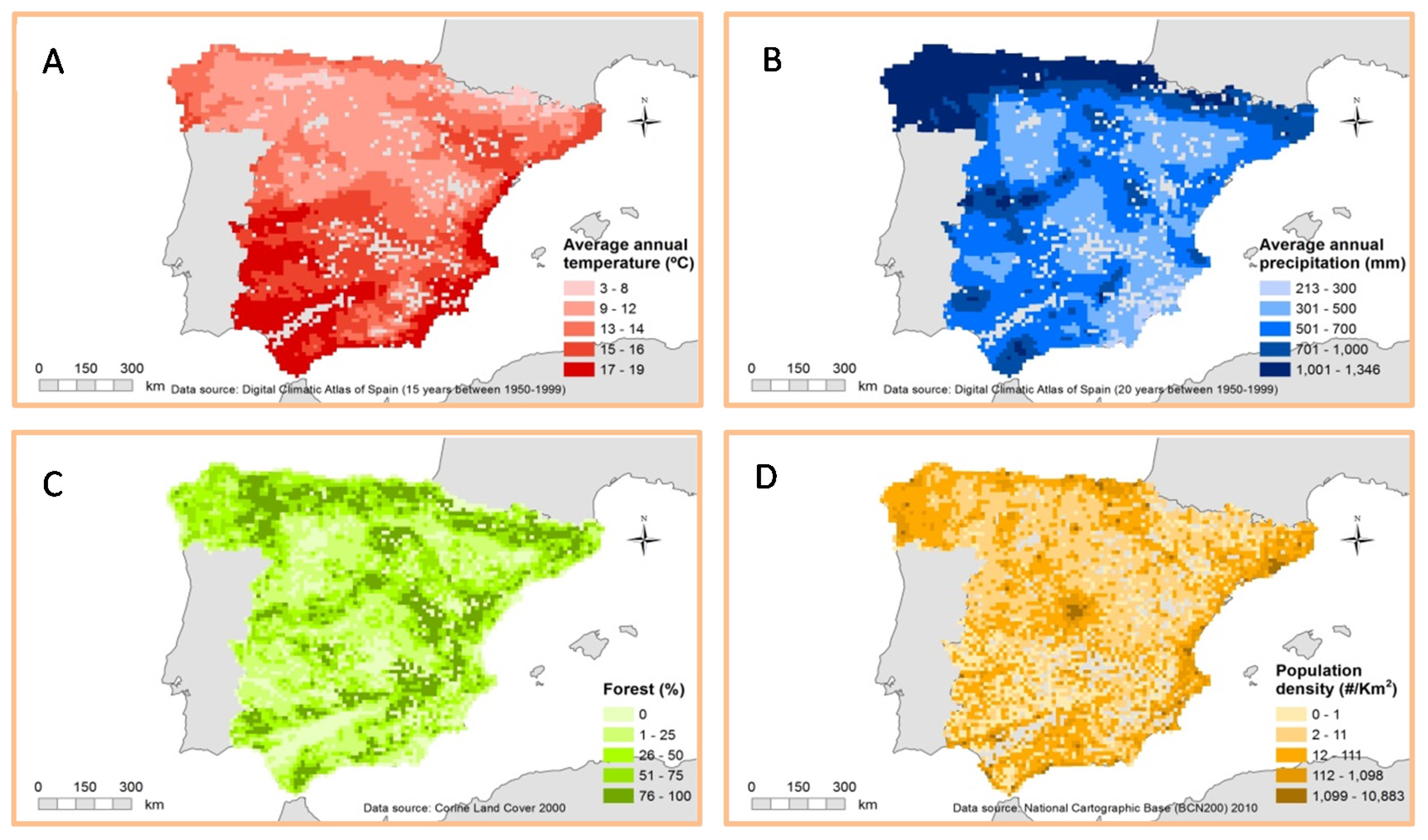
Figure 2.
Graphical representation of the RLQ analysis. Matrix L represents the p = 4 fire regime groups at n = 4652 sites and was analysed using correspondence analysis (CA). Matrix Q represents the q = 2 fire regime characteristics for each p fire regime group and was analysed using multiple correspondence analysis (MCA) with CA p weights. Matrix R represents the m = 20 environment characteristics for each n site and was analysed by principal component analysis (PCA) with CA n weights. Matrix D represents the fire regime characteristics-environment relationship and was analysed by a generalized singular value decomposition (GSVD).
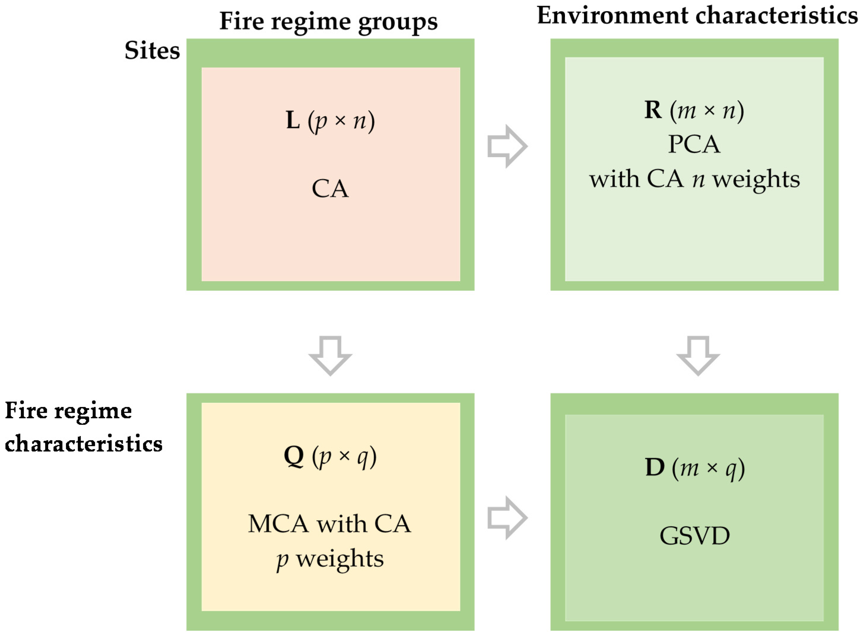
Figure 3.
The RLQ scores of fire regime groups, fire regime characteristics and environmental characteristics on the first and second RLQ axes and significance of both characteristics with both axes. Fire regime groups (upper right; grid size: 0.5 × 0.5), fire regime characteristics (lower right; grid size: 0.5 × 0.5) and environmental characteristics (left; grid size: 0.2 × 0.2). Characteristics significantly correlated with the first RLQ axis are emphasised in bold, with the second RLQ axis in italics, with both RLQ axes in green and not significant in regular. Fire regime (Fr) groups, from 1–4. High and low density of fire activity (High and Low). Long and short seasonality of fire activity (Long and short). Environmental characteristics symbolized by a dash represent indirect gradients based on climate and humans, the rhombi represent resource gradients based on forest potential productivity and land cover and triangles represent indirect gradients based on livestock grazing and land cover changes. Population density (Population), Seasonal temperature fluctuation (Temperature), Forest potential productivity (Fpp) categories, from 1–7. Cultivated and managed vegetation/agriculture (incl. mixtures) (Managed). Livestock density (Livestock).


Table 1.
Fire regime groups and fire regime characteristics data [32] used in this study.
| Fire Regime Groups | Number of 10 km × 10 km Cells | Fire Regime Characteristics | |
|---|---|---|---|
| Fire regime 1 | 703 | High density | Long seasonality |
| Fire regime 2 | 1083 | High density | Short seasonality |
| Fire regime 3 | 1582 | Low density | Short seasonality |
| Fire regime 4 | 1284 | Low density | Long seasonality |
Density refers to the number of fires or ha per km2 per year. Seasonality refers to the number of months with significant density.
| Environmental Gradients | Environmental Characteristics | Data Source | |
|---|---|---|---|
| Direct gradients | Climate | Humidity | Digital Climatic Atlas of Spain [31] (20 and 15 years between 1950–1999 respectively) |
| Seasonal temperature fluctuation | |||
| Human | Population density | National Cartographic Base (BCN200; 2010), National Geographic Institute | |
| Resource gradients | Forest potential productivity | Forest potential productivity 1 | Forest Potential Productivity map of Spain, 2000 [36] |
| Forest potential productivity 2 | |||
| Forest potential productivity 3 | |||
| Forest potential productivity 4 | |||
| Forest potential productivity 5 | |||
| Forest potential productivity 6 | |||
| Forest potential productivity 7 | |||
| Land cover | Needle-leaf trees | Corine Land Cover 2000 map, National Geographic Institute | |
| Broadleaf trees | |||
| Mixed trees | |||
| Shrubs | |||
| Herbaceous vegetation | |||
| Cultivated and managed vegetation/agriculture (including mixtures) | |||
| Indirect gradients | Livestock grazing | Livestock density | Rural census 2001, National Statistics Institute |
| Land cover changes | To forest | Corine Land Cover Change 1990–2000 map, National Geographic Institute | |
| To shrubs | |||
| From managed | |||
| Fire Regime Characteristics-Environment (RLQ Axes) | eig | covar | sdR | sdQ | corr |
| First RQL axis | 0.45 (96%) | 0.67 | 1.88 | 0.69 | 0.52 |
| Second RLQ axis | 0.02 (4%) | 0.14 | 1.51 | 0.73 | 0.13 |
| Environmental characteristics (Matrix R) | inertia | max | ratio | ||
| First RLQ axis | 3.54 | 4.10 | 0.87 | ||
| First and second RLQ axes | 5.84 | 6.78 | 0.86 | ||
| Fire regime characteristics (Matrix Q) | inertia | max | ratio | ||
| First RLQ axis | 0.47 | 0.53 | 0.90 | ||
| First and second RLQ axes | 1.00 | 1.00 | 1.00 | ||
| Fire regime groups (Matrix L) | corr | max | ratio | ||
| First RLQ axis | 0.52 | 1.00 | 0.52 | ||
| Second RLQ axis | 0.13 | 1.00 | 0.13 |
Fire regime characteristics-environment (RLQ axes) compare the eigenvalues (eig), covariance (covar), standard deviations (sdR and sdQ) and correlation (corr) of the two sets of scores projected on the RLQ axes. Environmental characteristics (Matrix R) and fire regime characteristics (Matrix Q), respectively, compare the inertia projected on the RLQ axes (inertia) to the maximum inertia on the axes of the PCA (max) and MCA ordination (max) in addition to a measure of concordance between the two projections (ratio). Correlation fire regime groups (Matrix L) compares the correlation projected on the RLQ axes (corr) to the maximum correlation on the axes of the CA ordination (max) in addition to a measure of concordance between the two projections (ratio).
© 2016 by the authors; licensee MDPI, Basel, Switzerland. This article is an open access article distributed under the terms and conditions of the Creative Commons Attribution (CC-BY) license (http://creativecommons.org/licenses/by/4.0/).
Share and Cite
MDPI and ACS Style
Moreno, M.V.; Chuvieco, E. Fire Regime Characteristics along Environmental Gradients in Spain. Forests 2016, 7, 262. https://doi.org/10.3390/f7110262
AMA Style
Moreno MV, Chuvieco E. Fire Regime Characteristics along Environmental Gradients in Spain. Forests. 2016; 7(11):262. https://doi.org/10.3390/f7110262
Chicago/Turabian StyleMoreno, María Vanesa, and Emilio Chuvieco. 2016. "Fire Regime Characteristics along Environmental Gradients in Spain" Forests 7, no. 11: 262. https://doi.org/10.3390/f7110262
Note that from the first issue of 2016, this journal uses article numbers instead of page numbers. See further details here.