Land Use, Conservation, Forestry, and Agriculture in Puerto Rico
by
William A. Gould
1,*, 
Frank H. Wadsworth
1,
Maya Quiñones
1,
Stephen J. Fain
2 and
Nora L. Álvarez-Berríos
1 1
United States Department of Agriculture, Forest Service, International Institute of Tropical Forestry, Jardín Botánico Sur, 1201 Ceiba St., Río Piedras, San Juan 00926, Puerto Rico
2
Pinchot Institute for Conservation, Western Regional Office: 721 NW 9th Ave Ste 240, Portland, OR 97209, USA
*
Author to whom correspondence should be addressed.
Forests 2017, 8(7), 242; https://doi.org/10.3390/f8070242
Submission received: 12 June 2017
/
Revised: 30 June 2017
/
Accepted: 3 July 2017
/
Published: 7 July 2017
(This article belongs to the Special Issue Tropical Forest Ecology and Management for the Anthropocene)
Abstract
:Global food security concerns emphasize the need for sustainable agriculture and local food production. In Puerto Rico, over 80 percent of food is imported, and local production levels have reached historical lows. Efforts to increase local food production are driven by government agencies, non-government organizations, farmers, and consumers. Integration of geographic information helps plan and balance the reinvention and invigoration of the agriculture sector while maintaining ecological services. We used simple criteria that included currently protected lands and the importance of slope and forest cover in protection from erosion to identify land well-suited for conservation, agriculture and forestry in Puerto Rico. Within these categories we assessed U.S. Department of Agriculture (USDA) farmland soils classification data, lands currently in agricultural production, current land cover, and current land use planning designations. We found that developed lands occupy 13 percent of Puerto Rico; lands well-suited for conservation that include protected areas, riparian buffers, lands surrounding reservoirs, wetlands, beaches, and salt flats, occupy 45 percent of Puerto Rico; potential working lands encompass 42 percent of Puerto Rico. These include lands well-suited for mechanized and non-mechanized agriculture, such as row and specialty crops, livestock, dairy, hay, pasture, and fruits, which occupy 23 percent of Puerto Rico; and areas suitable for forestry production, such as timber and non-timber products, agroforestry, and shade coffee, which occupy 19 percent of Puerto Rico.
1. Introduction
The question of how to best use land that provides food, forest products, water, and shelter, is as old as civilization. People have answered in a way that has allowed us to inhabit all corners of the earth, and thrive under a wide range of environments. Problem solved? Not exactly. As the population expands, technology advances, climate changes, and resource demands shift, questions persist as to how to sustain the flow of food, fiber, and ecosystem services. Globally, one of the most pressing challenges is population growth and the equitable distribution of resources. Recent projections by the United Nations Food and Agricultural Organization estimate global populations will reach 9.1 billion by 2050 (compared to 7.4 in 2017). Providing adequate nutrition to this many people will require an estimated 70 percent increase in food production. While the majority of this increase is projected to come from increased yields and cropping intensity on existing lands, agricultural land is expected to expand by 70 million hectares worldwide [1]. These projections highlight the need for effective land use planning, to balance local food production with other demands, such as urban development, water, biodiversity, forest products, and recreation.
The world is more interconnected than at any time in our history. Goods, services, energy, and information, flow at ever increasing rates. Connectivity and the pace of change challenges global, national, and local structures established to govern resources and implement land use decisions. Information about the distribution and state of resources is valuable in decision making processes. Planners and resource managers navigate complex landscapes of competing demands. Islands, like Puerto Rico, have limited land area and sharp boundaries between imported and local resources, such as food and water, which are dependent on climate and land use practices.
A key decision for any society, and particularly those on islands, is how to partition lands among the potentially competing uses of urbanization and residential use, conservation, forestry, and agriculture. In this paper, we develop a set of simple landscape characterizations to guide land use decisions toward lands most suitable for agriculture, forestry, and conservation. The central premise is that water, food, and forest products are valuable services generated from the land, along with recreation, conservation of biodiversity, energy production, and other services. Land use decisions can assess suitability, conflict, and compatibility, depending on the prevailing vision and needs of a society. These characterizations can help frame the discussion of what may be gained or lost in promoting a particular use in a given area.
Puerto Rico is one of over thirty island nations or territories in the Caribbean that share many similarities in climate, landscape features, flora, fauna, and agricultural crops. Since the 1960s, while there has been a greater-than-world average increase in agricultural productivity in Latin America and the Caribbean due to technological advances, the Caribbean islands have seen either little increase or a decrease in productivity [2]. With agricultural production in the region historically oriented toward crops produced for export, such as sugar cane, coffee, and tobacco, domestic food production has long been inadequate to satisfy domestic demand [3,4]. The decline in food production, and a subsequent increase in food imports, is contributing to reduced employment and increased impoverishment of rural communities in many countries [4,5]. Additionally, dependency on food imports makes regional food security vulnerable to fluctuations in global food prices, shortages and export blockades, transportation fuel prices, and the effects of climate change [3,5,6,7].
The history of forestry and agriculture in Puerto Rico is central to understanding the current matrix of forests, cities, protected areas and agricultural lands. Francisco Watlington [8] made some assessments of the agricultural carrying capacity of pre-Columbian Puerto Rico. Early accounts record a population of 600,000 indigenous inhabitants [9], not including women and children. Watlington makes the assumption of equal numbers of men and women, with on average four children, and arrives at an estimate of 3.6 million people—roughly equal to today’s population. Cassava (Manihot esculenta) was a staple food for indigenous people. Watlington estimates this population could have required about 90,000 ha of cultivated land to support the indigenous population.
Political and economic forces within and outside of Puerto Rico have generally driven land use over the last century [10]. Forest cover declined steadily from the late 1800s to the mid 1900s as the population grew, and much of the island was converted to intensive agriculture. During the second half of the 20th century, Puerto Rico transitioned from an agrarian economy based primarily on sugar cane, to one based on industry and services [4,10,11]. The abandonment of agricultural land was followed by rapid forest recovery across the island. Puerto Rico’s forest cover went from 6 percent in the 1950s [11], to 55 percent as of 2009 [12]. Loss of forest cover in the early part of the century led to the loss of a thriving timber industry, loss of traditional knowledge of using forest products, and greater importation of wood products. Agricultural abandonment in the second half of the 20th century, along with a boom in the industrial sector, led to a decrease in the relative economic importance of agriculture and an increase in food imports.
Puerto Rico currently imports over 80 percent of its food supply [13]. However, a new wave of initiatives is attempting to ensure food security by rebuilding a vital and ecologically conscious agrarian sector within the island. This includes developing new products and markets, and improving supply chains. The mission statement of the Puerto Rico Department of Agriculture is “food security through sustainable agriculture that is ecologically responsible.” One of its primary objectives is promoting sustainable agricultural practices and the expansion of local food production [14]. Other efforts toward improving food security and increasing local food production are arising in the island led by municipal and federal governments, as well as private and non-governmental organizations. These efforts reflect a broader, global movement to transform food production and supply chains toward models that empower local farmers, reconnect urban populations with food sources, improve farming practices, respect local knowledge and ecological conditions, and build climate resilience [15,16].
Prime quality agricultural land is a limited resource in Puerto Rico, and is defined as having soils with the necessary qualities to produce high crop yields when properly managed [17]. Urbanization and land degradation, including loss of topsoil, reduced soil water holding capacity, and loss of soil carbon, can depress agricultural production by reducing the availability of highly productive land, decreasing the sustainability of agricultural systems, and encouraging the use of less productive marginal lands [18]. Urban development in Puerto Rico has grown steadily over the last five decades, even with the population declining since 2000. Recent growth has been characterized as urban sprawl, with construction on soils suitable for agriculture [19,20]. López et al. [19] found that 42 percent of urban areas constructed in Puerto Rico between the years 1977 and 1994, were built on potential agricultural land, and that urban growth in Puerto Rico tends to occur on prime farmland, making the preservation of remaining agricultural land important to assuring food security for future generations.
Trends towards greater movement of people and goods lead to questions of what people value and want to see in their local landscape, i.e., what combination of living and industrial use, food and fiber production, recreation, and conservation, is most sustainable and leads to the highest level of human well-being. Land use conflicts can be a result of conflicting visions and a lack of knowledge of land suitability to deliver services [21]. While clearer, shared information about services may not resolve conflicting visions, it may provide a sound platform for decision making. This paper addresses a need for shared common knowledge about the suitability of specific components of the landscape to deliver services related to agriculture, forestry, and conservation.
In this study, we characterized the lands of Puerto Rico into four categories: impervious surfaces (developed lands and roads) based on remote sensing analyses [22], lands best suited for conservation based on the current protected areas network and other conservation priorities [23], and two categories of working lands with potential for agriculture and forestry, and less prone to erosion, based on slope and land use [24,25]. Within these broad categories, we assessed the current land cover, current zoning classification under the Puerto Rico Land Use Plan, and Natural Resources Conservation Service (NRCS) farmland soil characterizations. These characterizations of suitability support the assumption that clean water and healthy soils provide ecosystem services and are important to a sustainable society. These services can be lost by conversion of open space to developed land, and by erosion of exposed slopes leading to sedimentation in reservoirs, estuaries, and coastal waters [26].
2. Materials and Methods
We developed a set of simple criteria to identify areas well-suited to mechanized agriculture, well-suited to non-mechanized agriculture on moderate to steep slopes, and areas suitable for forestry practices, including timber harvest potential, where greater forest cover has benefits in terms of soil conservation and water management. These are steeper slopes where timber production may be integrated with agroforestry, shade coffee, non-timber forest product uses, or other forms of sustainable activity that maintain a high degree of forest cover. Criteria were developed based on literature review, expert opinion, and geospatial data availability. The agriculture and forestry models used slope and land cover parameters to identify the land with the highest potential for these activities, while excluding areas with developed land and a high degree of conservation potential. We characterized areas with high agriculture and forestry potential by patch size, and summarized by municipality. We also assessed lands identified with agricultural potential following the USDA Natural Resource Conservation Service (NRCS) soils and farmland classification. Finally, we developed a map of areas with highest potential for conservation, agriculture, and forestry, excluding currently developed lands. We assess the spatial distribution of current agricultural production, land cover, and land use planning objectives, in terms of our classification.
2.1. Lands Well-Suited for Agriculture
We identified land with agriculture potential within two slope ranges. One identified relatively flat land (under 10 percent slope), optimal for mechanized agriculture [27], while the other identified potential agricultural land with moderate slopes (10 to 20 percent). We calculated slope percentage using the 10 m pixel Digital Elevation Model (DEM) from the US Geological Survey (USGS) National Elevation Dataset (NED) for Puerto Rico [28]. We used the land cover of Puerto Rico for the year 2000 [22] with a spatial resolution of 15 m. We excluded wetlands, developed land surface, and natural barrens (i.e., fresh and ocean water, mudflats, riparian and other natural barrens, gravel and sandy beaches, and rocky cliffs) from lands with agricultural potential. We also excluded Puerto Rico’s protected areas [23], and all the cays and small islands. We excluded riparian zones, identified as 50 m on each side of perennial streams and rivers, and reservoirs, to protect water bodies from erosion and contaminants [29,30]. The zones were created by delineating a buffer around the rivers using the National Hydrography Dataset [31], and reservoirs, using data from the Puerto Rico Department of Natural and Environmental Resources.
2.2. Lands Well-Suited for Forestry
We identified land with forestry (timber production) potential as having slopes from 20 to 50 percent using the 10 m NED derived slope dataset. We did not include protected areas [23], wetlands, developed land surface, natural barrens [22], riparian zone 50 m buffers, or watersheds that contain reservoirs, as areas suitable for timber production. These watersheds were excluded given their role in reducing sedimentation and protecting important water sources for Puerto Rico’s reservoirs.
2.3. Farmland Soils
We identified soil classes of the U.S. Department of Agriculture (USDA) Natural Resources and Conservation Service (NRCS) farmland classification of soils within lands we identified as well-suited for conservation, agriculture and forestry. The farmland classification attribute identifies NRCS soil map units under the categories of prime farmland, farmland of statewide importance, conditional prime farmland (i.e., prime farmland if irrigated, prime farmland if drained, prime farmland if irrigated and reclaimed of excess salts and sodium), and farmland of statewide importance, if irrigated. The classification system is based on a combination of physical and chemical characteristics of soil desirable for producing food, feed, forage, fiber, and oilseed crops [17]. We quantified the NRCS farmland soils that were outside of those we classified as well-suited to agriculture, identifying according to the following characteristics: Protected areas, developed land, wetlands, natural barrens, slopes over 20 percent, and river and reservoir 50 m buffers.
2.4. Lands Well-Suited for Conservation, Agriculture, and Forestry Uses
We characterized all open space, or unbuilt lands in Puerto Rico, as well-suited to conservation, agriculture, and forestry uses. These exclude developed land, based on Gould et al. [22], and additional impervious road surfaces [32], and include lands well-suited for agriculture, including row crops, orchards, hay, pasture, and dairy; areas well-suited for forestry, including timber production, agroforestry, shade coffee, livestock grazing, and non-timber forest product uses; and areas well-suited for conservation, including the protected areas of Puerto Rico [23], wetlands, lands over 50 percent slope, and natural barrens (i.e., fresh and ocean water, mudflats, riparian and other natural barrens, gravel and sandy beaches, and rocky cliffs) based on Gould et al. [22], cays and small islands, and riparian zones of 50 m to each side of the rivers and reservoirs.
2.5. Current Agricultural Productivity
We assessed the relationship of lands we identified as well-suited to agriculture with the current spatial extent of areas under agricultural production. We used information from the Farm Service Agency (FSA) common land units. The common land unit (CLU) dataset consists of digitized farm tracts and field boundaries, and associated attribute data. These identify farm tracts enrolled in FSA programs and eligible for USDA support. Farm tracts are defined by FSA as sets of contiguous fields under single ownership. Common land units are used to administer USDA farm commodity support and conservation programs in a GIS environment. Not all land under production is enrolled in these programs so they underestimate land in production in that sense, and not all of tract area is in production so they overestimate land under production in that sense.
2.6. Current Land Cover and Zoning
We assessed the relationship of lands we identified as well-suited to agriculture, forestry, and conservation in terms of their current land cover based on Gould et al. [22], and in terms of lands identified in the Puerto Rico Land Use Plan [32] as either water, roads, specially protected rustic (rural) lands (for agriculture or in combination with agriculture), common rural lands, specially protected rustic lands (for conservation, not agriculture), lands with urban potential, or urban lands [32].
3. Results
3.1. Lands Well-Suited for Agriculture
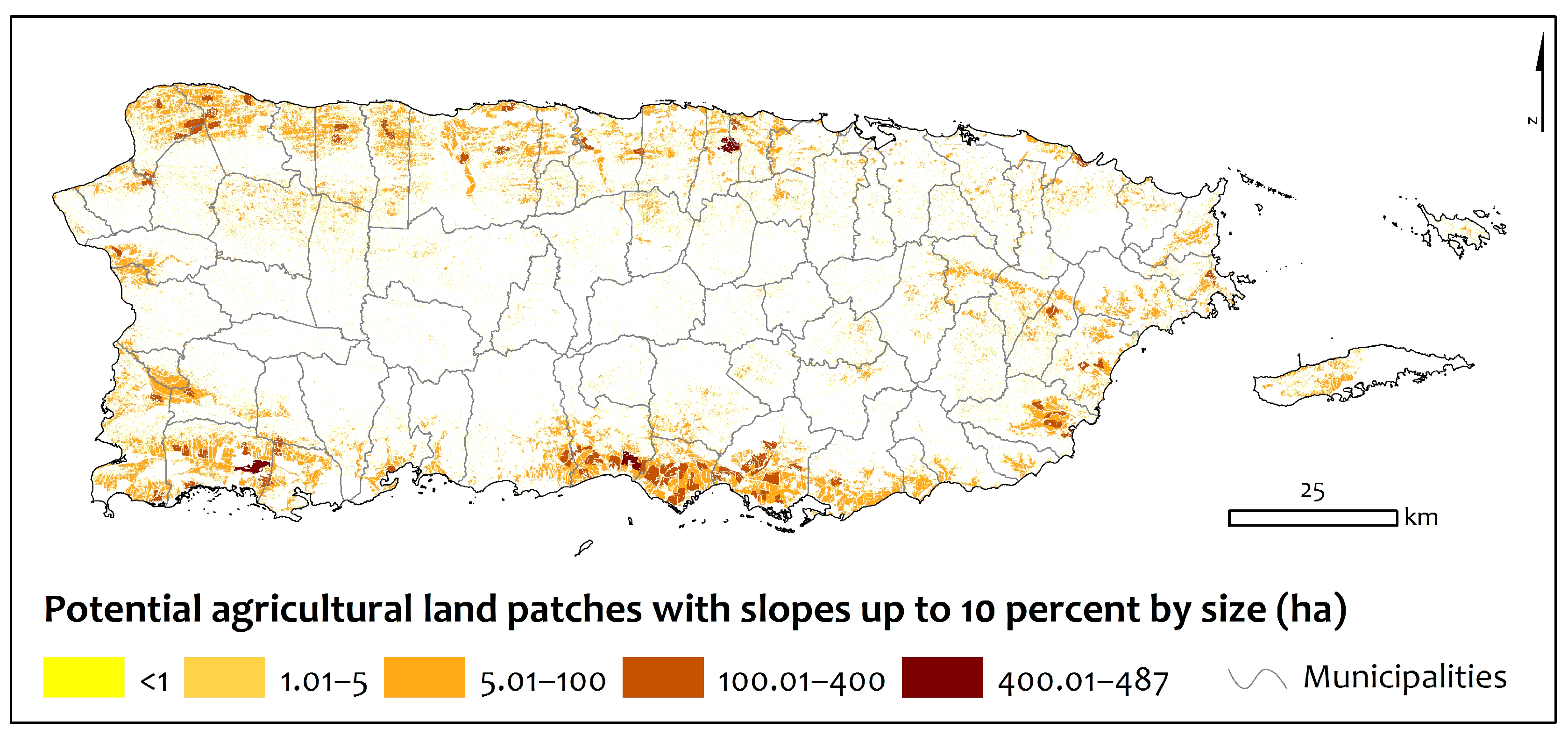
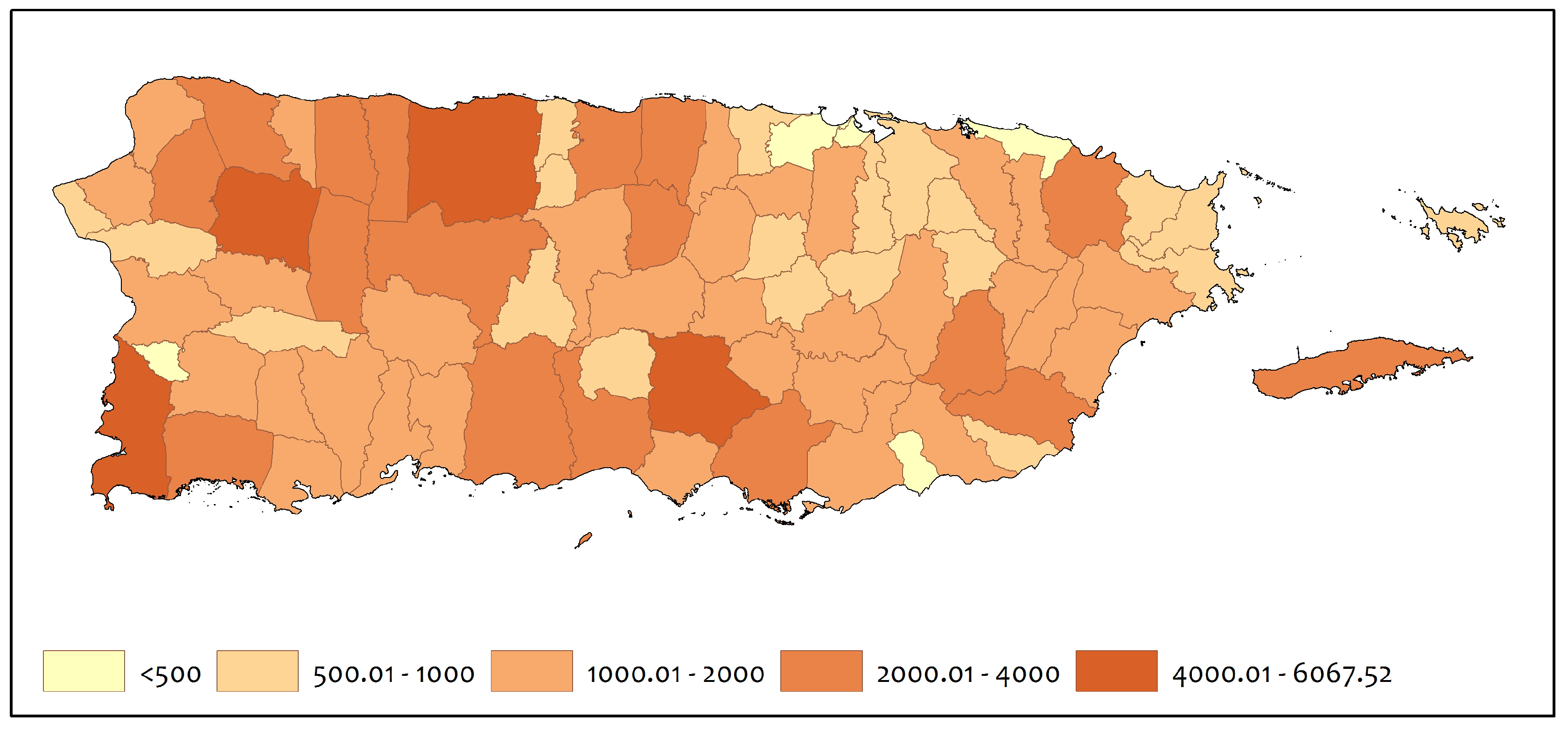
Vicente-Chandler [33] identified 106,120 ha (262,228 acres), or 12 percent of Puerto Rico, as suitable for mechanized agriculture [27]. In this assessment, we identify 124,187 ha (306,873 acres), or 14 percent of Puerto Rico, as well-suited to mechanized agriculture, with slopes under 10 percent (Table 1, Figure 1 and Figure 2). This land is mainly located in the coastal plains and interior valleys, with the largest patches located in the northwest and south of the island. The coastal and interior plains of Puerto Rico encompass a total of 240,000 ha (27 percent of all land). Of these, 142,292 ha (16 percent) are classified by the Puerto Rico Department of Agriculture as agricultural reserves, and 98,247 ha (11 percent of all land) are developed. Within the agricultural reserves, 21,774 ha (15 percent) are wetlands, 16,072 ha (11 percent) are currently forested, and 6015 ha (4 percent) are conservation protected areas. The difference between the areas identified in this analysis, and land within the agricultural reserves not identified above (25,589 ha), include riparian and reservoir buffers, saline mudflats, beaches, interior waters, and other barrens not suitable for agriculture. The municipalities with the largest amount of land with agriculture potential under 10 percent slopes include Arecibo, Salinas, Lajas, Santa Isabel, and Cabo Rojo, all with over 4000 hectares (≈10,000 acres) (Appendix A, Figure A1, Table A1).
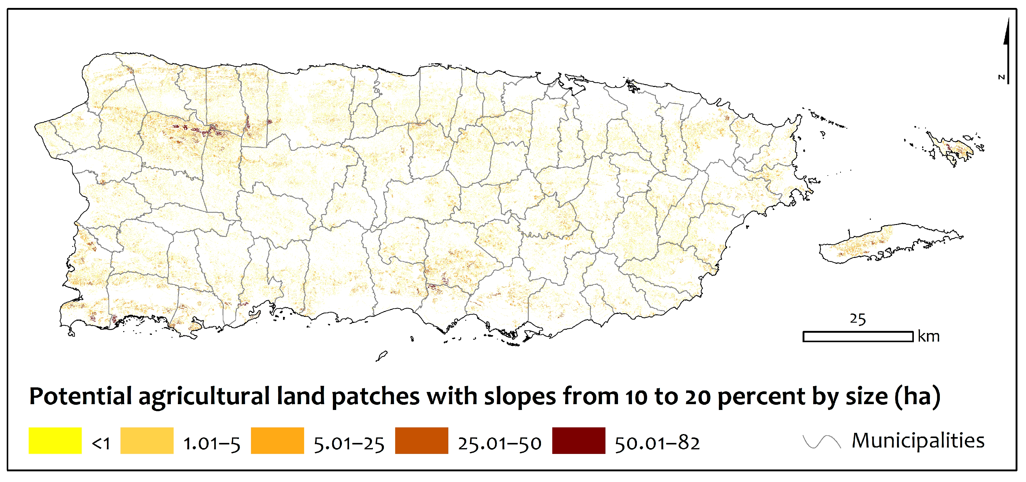
We identified 84,574 ha (208,987 acres) of land—nine percent of Puerto Rico—as well-suited to non-mechanized agriculture on moderate (10–20 percent) slopes (Figure 2). The largest areas were located in the northern karst belt, and the southwest of the island, with noteworthy areas in Vieques and Culebra. The municipalities with the largest amount of land well-suited to non-mechanized agriculture on moderate slopes are San Sebastián, Arecibo, Cabo Rojo, and Coamo, all with over 4000 hectares (≈10,000 acres) (Appendix A, Figure A2, Table A1).
3.2. Lands Well-Suited to Forestry
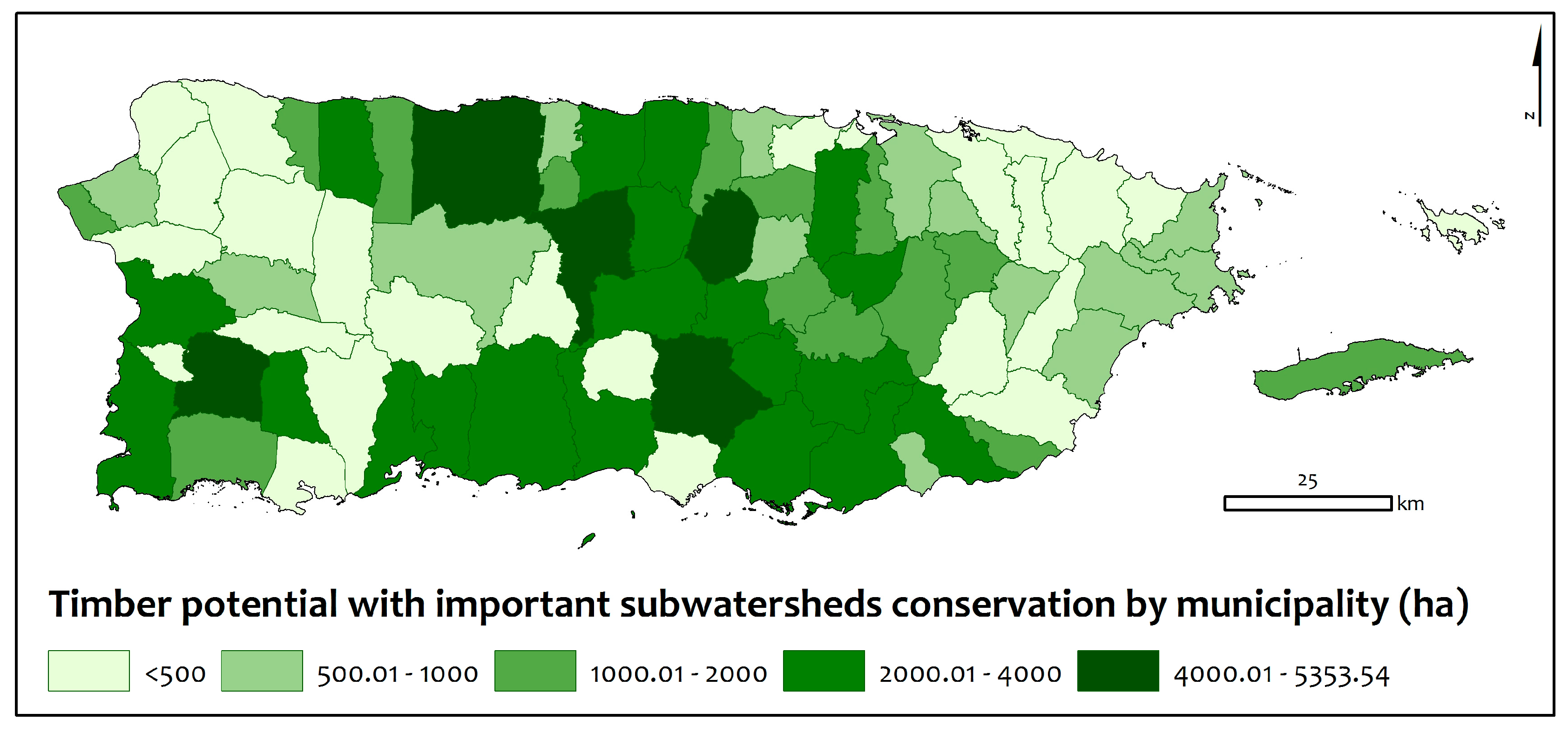
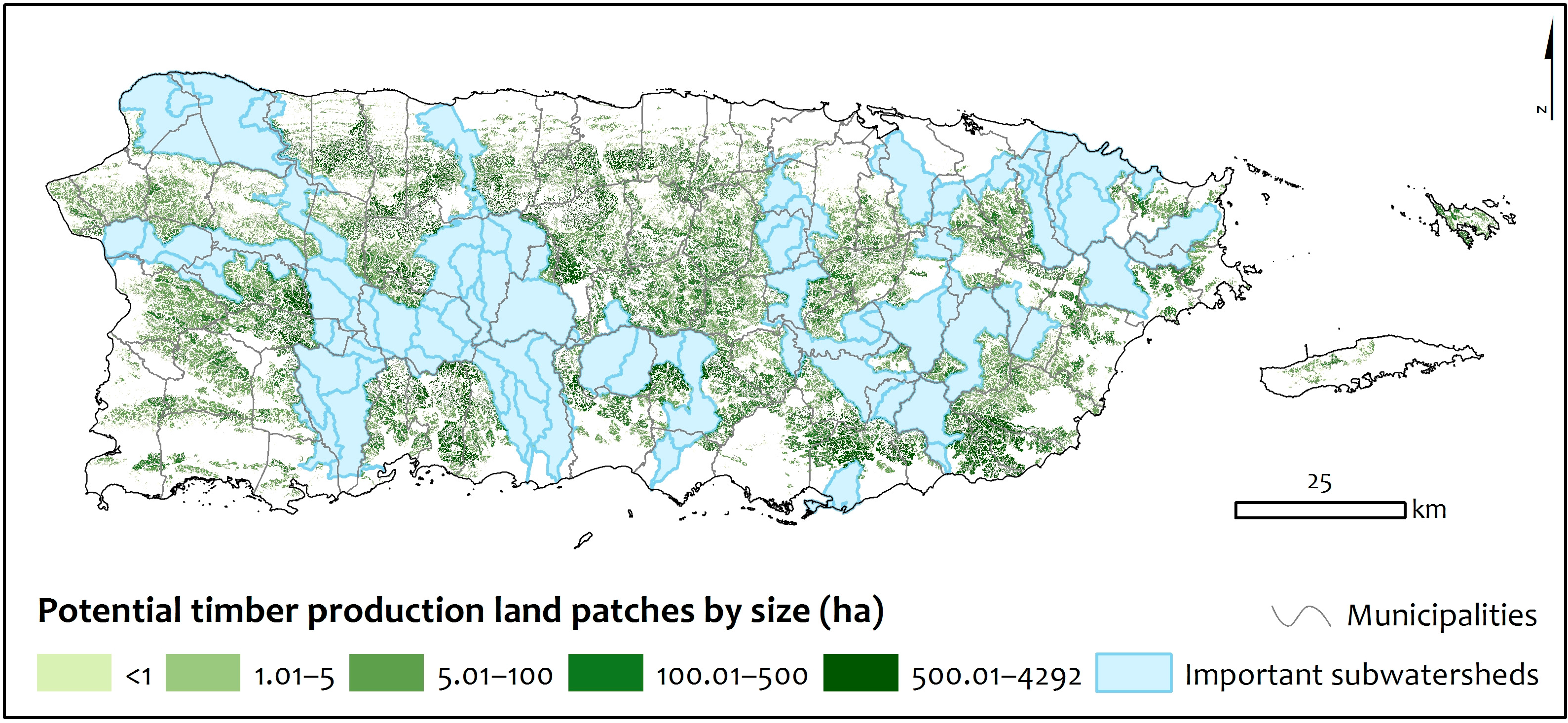
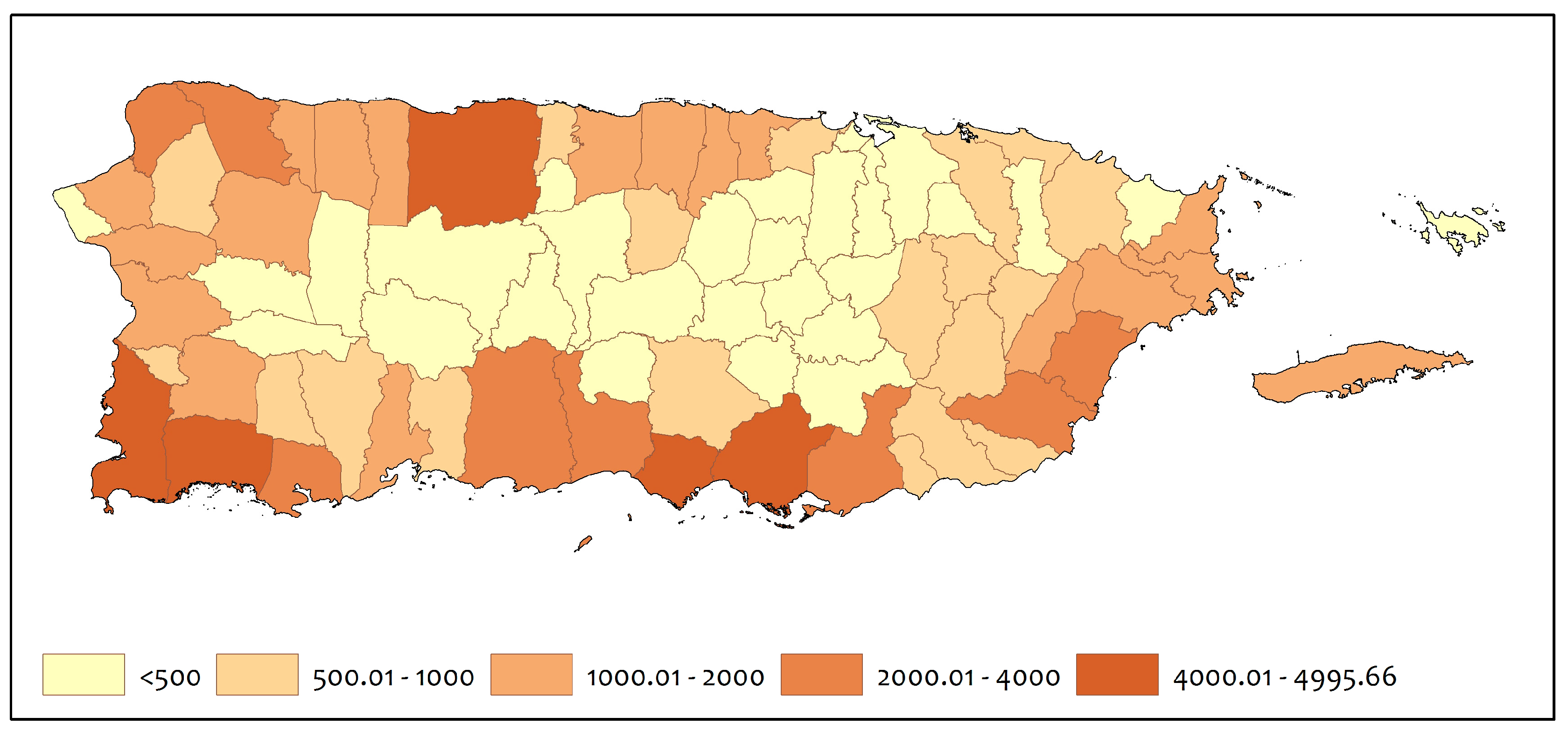
A total of 169,125 ha (417,917 acres)—about 19 percent of Puerto Rico—were identified as well-suited for forestry production, while excluding watersheds that supply water to Puerto Rico’s reservoirs (Figure 3). These lands are located across the hills and mountains in the main island of Puerto Rico, with large areas in the central mountains, northern karst hills, southern hills, and small patches in Vieques. The municipalities with the largest amount of land with forestry potential are Arecibo, Coamo, San Germán, Corozal, and Ciales, all with over 4000 hectares (≈10,000 acres) (Appendix A, Figure A3, Table A1).
3.3. Farmland Classification of Soils
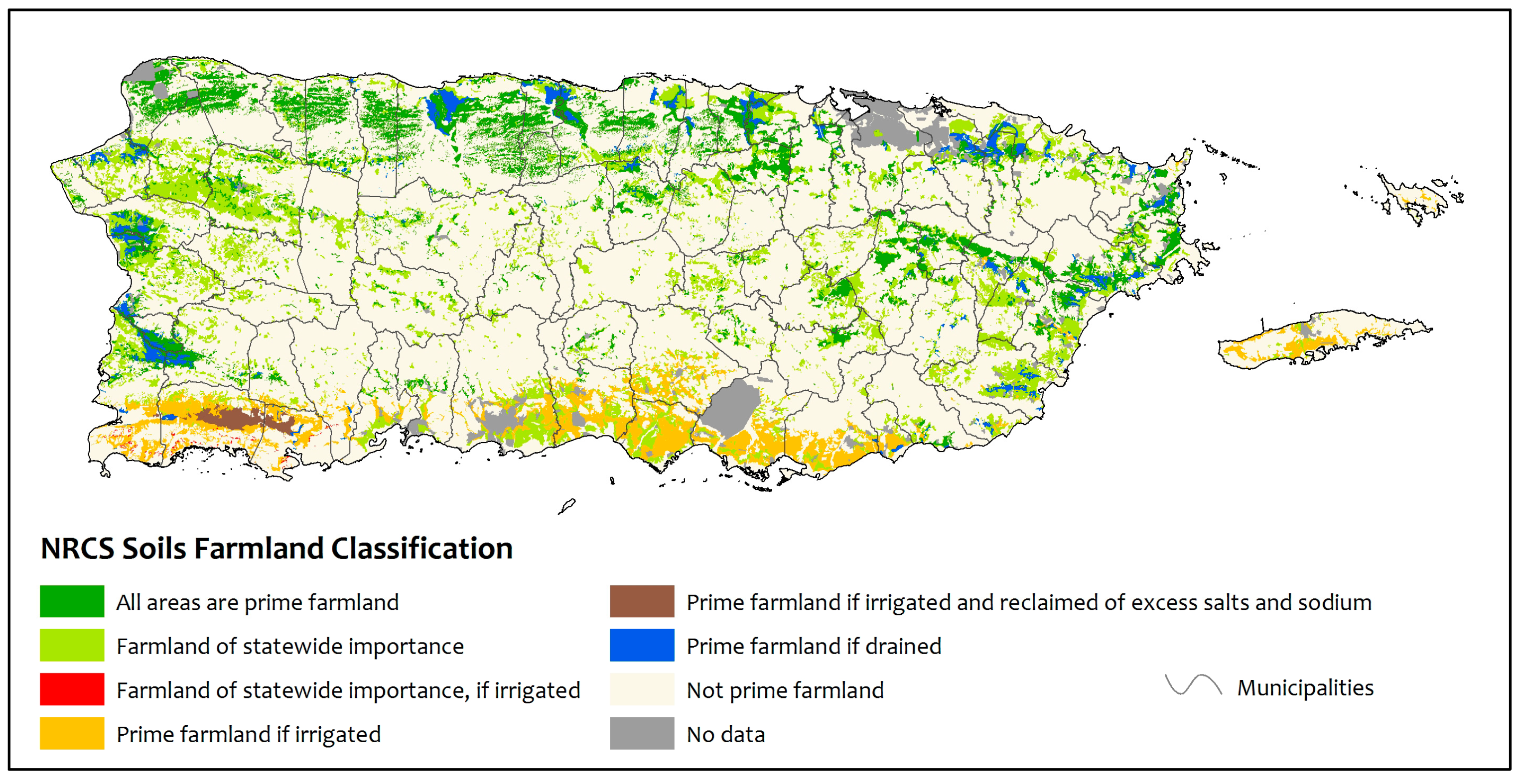
Classified farmland soils cover just under 26 percent of Puerto Rico. Following NRCS classifications, 9 percent of Puerto Rico’s soils are classified as prime farmland (Figure 4); 11 percent are classified as farmland soils of statewide importance, and 6 percent as conditional farmland soils. This includes farmland soils of statewide importance, if irrigated (<1 percent), prime farmland if irrigated (4 percent), prime farmland if irrigated and reclaimed of excess salts and sodium (<1 percent), and prime farmland if drained (2 percent).
Sixty-nine percent of the lands we have identified as well-suited for mechanized agriculture are classified as farmland (42 percent) or conditional farmland (27 percent). Of the non-conditional farmland soils, 26 percent were classified as prime farmland soils and 16 percent as farmland soils of statewide importance, while 27 percent included soils classified as not prime farmland, and 4 percent had no data (Figure 5, Table A2). The numbers were very different for lands we characterized as well-suited for non-mechanized agriculture with slopes from 10 to 20 percent. More than half of the land resulting from this model contained soils classified as not prime farmland (60 percent) and only 14 percent and 18 percent were classified as prime farmland soils and farmland of statewide importance respectively; 6 percent were classified as conditional prime farmland and 2 percent had no data (Figure 5, Table A2). The prime farmland classification identifies soils with the best quality, dependable moisture supply, favorable temperature and growing season, acceptable acidity or alkalinity, not excessively erodible or saturated for long periods, an acceptable salt and sodium content, and few or no rocks, i.e., characteristics needed to economically produce sustained high yields of a wide variety of crops, including row crops, fruit trees, and forage, when properly managed and using modern farming techniques [34]. Prime farmland soils are considered a limited resource by the USDA. However, the classification does not imply that soils classified as not prime farmland cannot be cultivated successfully.
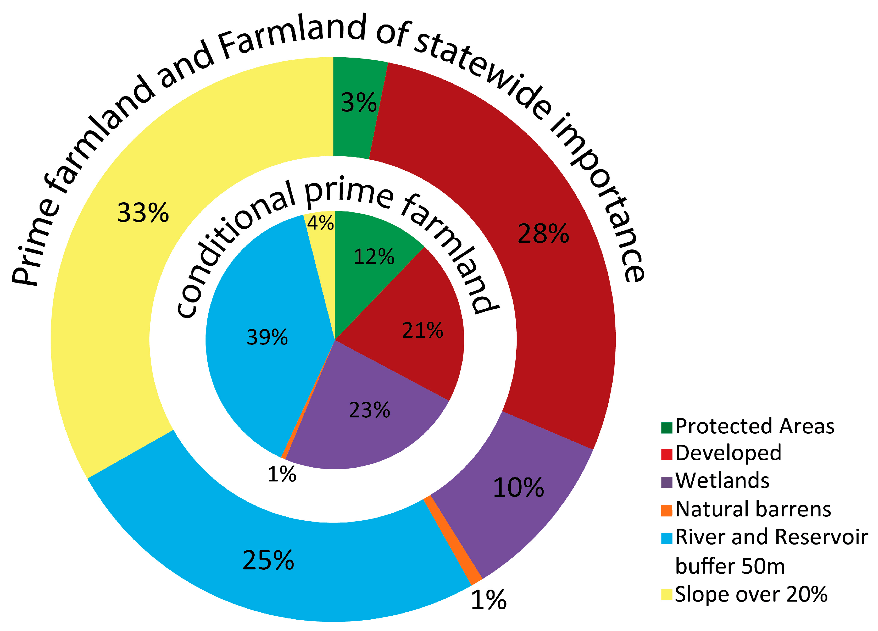
A total of 120,030 hectares of prime farmland soils (97,150 ha) and conditional prime farmland soils (22,879 ha) were located outside land modeled to be well-suited for mechanized and non-mechanized agriculture. These farmland soils were located across all the features excluded from lands well-suited to agriculture, but were mostly found in land with slopes over 20 percent, river and reservoir 50 m buffers, protected areas, developed areas, and wetlands (Figure 6).
3.4. Characterizing Suitability for Conservation, Agriculture, and Forestry
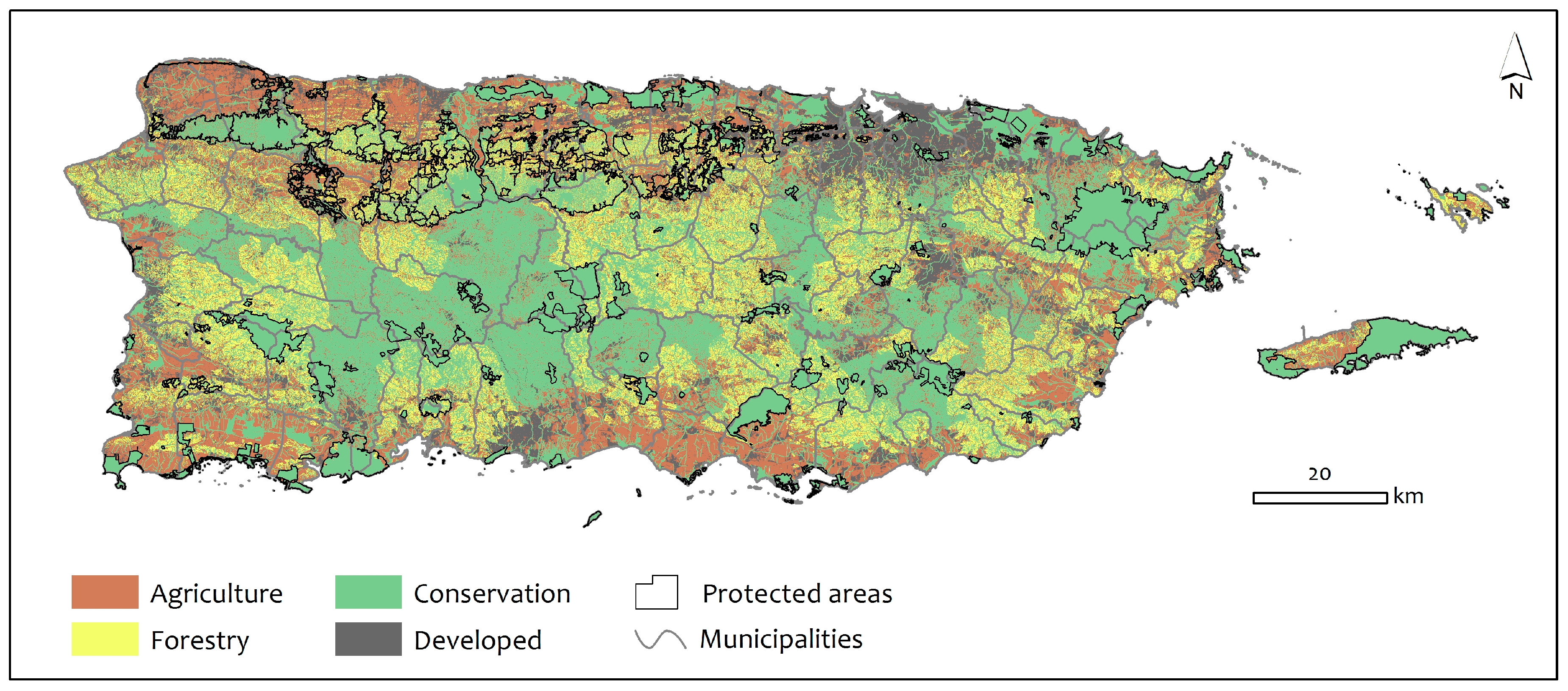
We used the aforementioned classifications to characterize the Puerto Rican landscape by lands currently developed, and by lands well-suited to conservation, agriculture, and forestry (Figure 7). These characterizations are not exclusionary. Complimentary uses exist that cut across all categories. For example, conservation, urban forestry, and urban agriculture are all compatible to some extent with development; conservation of soil, water, and wildlife are compatible with agriculture and forestry practices; and forestry activities in particular, can be sustainable and complementary with protected areas and conservation. Lands designated as well-suited to forestry can contribute to the agricultural potential of Puerto Rico, using practices such as agroforestry, coffee production, apiculture, livestock grazing, agrotourism, and renewable non-timber forest products. Lands well-suited to conservation practices, and excluded from agriculture and forestry lands, have potential to sustainably produce forest products while maintaining conservation priorities. This includes sustainable forestry practices that retain forest cover in state and national forests and in riparian and reservoir buffers.
We find that current impervious surfaces (roads and developed lands) occupy 13 percent of Puerto Rico, Vieques and Culebra; lands well-suited for conservation—including protected areas riparian and reservoir buffers, subwatersheds surrounding reservoirs, wetlands, and barrens such as salt and mudflats, beaches, slopes greater than 50 percent and water bodies, occupy 45 percent of Puerto Rico; lands well-suited for mechanized and non-mechanized agriculture—including row crops, livestock and dairy, hay and pasture, fruits, and other specialty crops, occupy 23 percent of Puerto Rico; and areas suitable for forestry production—including timber, non-timber forest products, agroforestry, coffee, apiculture, livestock grazing, and agrotourism, occupy 19 percent of Puerto Rico.
3.5. Lands in Agricultural Productivity
Various methods are used to assess land under cultivation or other agricultural use, and the location of those lands. Each assessment has strengths and limitations. The National Agricultural Statistical Survey (NASS) takes place every 5 years and captures information reported by farmers [35]. These assessments indicate 219,109 ha were under cultivation in 2007, and 229,900 ha in 2012, or 26 to 28 percent of Puerto Rico, respectively. The FSA assesses farm tract locations, and the extent of those tracts that are registered as active farms and eligible for conservation and farm assistance from the USDA. From 2007 to the present, 106,955 ha or 13 percent of Puerto Rican lands have been enrolled with FSA, and their lands are mapped as Common Land Units. This is about half of the farmland captured by the NASS. Of these areas, it is estimated that about 80 percent are in cultivation, and 20 percent in other uses, such as conservation buffers. Of the lands identified by FSA, 38 percent are located on those lands well-suited for agriculture, and 62 percent on those lands well-suited for forestry production, indicating many of the farms in the FSA program are on steeper slopes and within areas well-suited for shade coffee, agroforestry, timber, and non-timber forestry production. Only about 19 percent of those lands we have identified as well-suited for agricultural production have been enrolled in the FSA program in the last five years.
3.6. Current Land Cover and Land Use
Twenty-two percent of the lands characterized as well-suited for agriculture are currently forested, with 13 percent as woodland or shrubland, and 65 percent with grassland, row crops, or other agriculture (Table 2). Fifteen percent of the forested lands in Puerto Rico occur on lands well-suited to agriculture. Sixty-eight percent of the lands well-suited to forestry are currently forest or woodland. Seventy-four percent of the lands well-suited to conservation are currently forest or woodland. This includes all of the forested wetlands, both coastal mangroves, and montane cloud forests. Seventy-eight percent of lands well-suited to agriculture are currently non-forest or shrubland; most of these lands are either lands under agricultural production, pasture, abandoned agriculture, or otherwise managed non-forest lands.
The Puerto Rico Land Use Plan [32], approved by the Puerto Rico legislature, designates 28 percent of the island as specially protected rural lands for agriculture, or in combination with agriculture. Thirty-four percent of these occur on lands we designate as well-suited for agriculture, 19 percent on lands we designate as well-suited for forestry, and 46 percent on lands we designate as well-suited for conservation (Table 3). Additionally, the Land Use Plan designates 32 percent of Puerto Rico as specially protected rural lands for conservation, not agriculture. We designate 64 percent of these lands as well-suited for conservation, 21 percent as well-suited for forestry, and 14 percent as well-suited for agriculture. The Land Use Plan designates 14 percent of Puerto Rico as urban or potentially urban lands. We designate 54 percent of these lands as either well-suited for conservation, agriculture, or forestry. While the Land Use Plan and this study are in general agreement, important differences are that much of what the Land Use Plan designates as urban, or potentially urban, are currently open spaces that, in this study, are characterized as well-suited for forestry, conservation, or agricultural production. Additionally, many of the lands designated for agriculture in the Land Use Plan, are characterized as well-suited for conservation in this study (46 percent), and 34 percent of the lands designated for conservation in the Land Use Plan are identified as well-suitable for forestry or agriculture in this study.
4. Discussion
Increasing the productivity of food and forest products and services from Puerto Rican lands can serve to increase economic stability, increase food security, improve the freshness and quality of food products, and reduce the risks associated with climate change and food insecurity [6,13]. Additionally, Puerto Rico is a tropical island with a long history of agricultural and ecological research, high capacity for using technological tools in planning and in agriculture, highly educated population, and rich in natural resources. Puerto Rico has the potential to be a leader in demonstrating how to increase food security while maintaining a balance of agriculture and forestry production, conservation, and urban, residential, and commercial uses of a finite landscape. Addressing this problem in Puerto Rico can be broadly useful, as many nations with less capacity are addressing similar problems as global populations grow, and food, water, and living space needs increase, and climate change adds uncertainty to the future.
We classified and mapped all lands in Puerto Rico at a fine spatial resolution as to whether they are built or unbuilt surfaces, and as to the suitability of currently open space for conservation agriculture, and forestry, based on slope, and criteria such as proximity to rivers, presence of wetlands, and protected status. These categories are far from mutually exclusive, nor are potential practices homogeneous in terms of sustainability, service delivery, or broader effects. The classification provides a basis for quantifying the extent of suitable areas, and for estimating the effects of land use choices within the context of the broader picture of what potential services the land provides. The classes broadly mirror current uses in the sense that lands well-suited to agriculture are primarily non-forested, and lands well-suited to forestry and conservation are forested. However, much of lands well-suited to agricultural production are pasture or abandoned pasture, and not intensively managed. Additionally, timber production is almost nonexistent on the lands suitable for that use. Finally, the majority of the lands well-suited to conservation are outside of protected areas or other conservation mechanisms [23].
In assessing the urban and residential component of the landscape, we used mapped developed land, or impervious surfaces derived from satellite remote sensing analyses from the year 2000 [22], and the current road network [32]. This is likely a conservative estimate of lands not suited for agriculture and forestry due to urban uses, as it excludes lawns, road right-of-ways, and golf courses, among other things. Notwithstanding, innovative approaches to urban agriculture, such as backyard conservation, roof top gardens, hydroponic production, or vertical agriculture [36,37,38], can lead to food production, even within this component. Permeable surfaces that have potential for conservation, agriculture, and forestry, but are typically managed for other uses, such as residential, recreational, or transportation corridors, are of interest as mechanisms to increase food security, habitat, and ecosystem services [39]. As such, we included these surfaces as components of the lands well suited to either conservation, agriculture, or forestry. The 13 percent of lands characterized as “developed” in this analysis represent the impervious infrastructure of Puerto Rico. There is continued pressure to revamp the construction sector and convert permeable lands to impervious surfaces, even in light of the declining population over recent decades [40]. Projected population levels for Puerto Rico are expected to continue to decline over the next decade, due to economic conditions and emigration [41]. Additionally, much of the existing infrastructure is underused as population declines have been greater in urban centers than suburban and rural areas [20,42], leaving room for potential redevelopment and modernization of current infrastructure without encroaching on permeable lands. Likely increases in impermeable surfaces include transportation corridors, and commercial and residential development. Future conversion from permeable to impermeable surfaces may relate to the reduced cost of building on existing open space vs. redeveloping urban space, desired ambiance of non-urban settings for development, proximity to existing development, or other reasons. This analysis serves as a basis for decisions as to what well-suited uses will be lost in conversion from open space to impermeable surfaces.
In assessing those lands most well-suited to conservation uses, we broadly defined those areas as including all formally protected lands [23,43,44], with the addition of marginally productive lands, such as salt flats, and small cays and islands, wetlands, lands susceptible to erosion, such as slopes over 50 percent, and lands that protect water resources, such as riparian buffers and catchments for the reservoirs which supply Puerto Rico with water. This is the largest component of the landscape in this study, and represents nearly half of the land area of Puerto Rico. Twenty percent of these lands are set aside as protected areas. Over 60 percent are characterized as well-suited to conservation due to their value in conserving water quantity and quality, such as riparian buffers or catchment protection, and over 30 percent are on steep slopes and unsuitable for agriculture and forestry. Much of the steep slopes, catchment and riparian areas co-occur within protected areas, increasing their conservation value. All of these lands have varying degrees of potential for forestry and agriculture production co-occurring with conservation uses and maintaining conservation value. Designating them as lands well-suited to conservation, indicates that they are also well-suited to providing ecosystem services to the larger society. Innovative practices on public and private lands that value ecosystem services or integrate conservation, forestry, and agricultural goals, can help increase the benefit to individual owners, while maintaining value, such as water services, which benefit the larger society [45].
We characterize nearly 20 percent of the island as land well-suited to forestry. We balance the interest in forestry productivity with interests in agricultural productivity and water conservation, as this use is intermediate between intensive agriculture and forest preservation. Low impact forest harvest methods provide forest cover, habitat, and watershed protection from erosion [46,47,48]. Puerto Rico, at one time, had a thriving timber industry, producing fuel, furniture, and building materials to meet all of its needs [49,50]. The decline of forest cover due to increasing agricultural activity, led to the loss of the timber industry and associated markets and supply chains. A reinvigoration of that industry has economic and social benefits, in that value added post-harvest wood product development can substantially increase the value of timber production, provide jobs, and serve as an intermediate land use option that maintains many essential ecosystem services, and protects soils from degradation [51,52,53,54]. We consider the lands well-suited to forestry in a broad context. This includes agroforestry, such as shaded pastures for livestock, shade coffee, and the use of non-timber forest products, including beekeeping and honey production as uses well-suited to this component of the landscape.
Finally, we characterize 208,761 ha, nearly one quarter of the island, as well-suited for mechanized and non-mechanized agriculture. Current estimates indicate about 28 percent of the island is farmland, but a much smaller proportion cultivated as cropland (50,000 ha), and a large portion as idle lands, rangeland, brush, or other farm uses (90,000 ha) [54]. Current practices are producing only about 15 percent of food needs for Puerto Rico. Vicente Chandler [33] describes in detail how better utilization of the landscape, i.e., improved multisectorial planning, matching crops with optimal soil and water availability, modernizing practices, and taking advantage of the diversity of soils and environments to develop diversified farming operations, can greatly increase productivity on the lands well-suited for agriculture. These estimates [32], along with the spatial analyses of this study, indicate the potential to increase agricultural and timber production in Puerto Rico. Lands well-suited for agriculture also have the potential to integrate conservation and forestry practices that can provide ecosystem services, including riparian buffers, woodlots, and agroforestry.
Characterizations of what lands are well-suited for agriculture, forestry and conservation indicate that forest cover, biodiversity and ecosystem services can be maintained while increasing agricultural productivity on flatter lands and lower slopes, and integrating agroforestry, shade coffee, low impact timber harvest, and non-timber forest product uses on steeper slopes. Given the relatively small size and mountainous terrain of Puerto Rico, innovation will be important to keep key watersheds and mountain slopes forested, and to increase sustainability and productivity on all working lands. Additionally, best practices in all agricultural operations will improve productivity per land unit area. These include improved crop varieties, improved water and nutrient management, and integrating value-added farming operations that include specialty crops, livestock, timber products, and agrotourism [13].
The interface of each of the four land uses assessed in this study have potential for integration and for conflict. Perceived conflict between urban development and agriculture are critical to address, as are perceived conflict among agriculture, forestry and conservation. The definition of prime farmland from the USDA NRCS states that prime farmland cannot be “urban or built-up land or water areas” [36]. Our findings, however, show that 15,254 hectares of soils classified as prime farmland (20 percent of all prime farmland soils), 12,217 hectares as farmland of statewide importance (12 percent of all farmland soils of statewide importance), and 4716 of conditional farmland (9 percent of all conditional farmland soils) overlap with developed (i.e., built-up) surfaces. As part of the farmland classification definition, the NRCS documented the recent land cover conversion trend from prime farmland to industrial and urban uses, which puts pressure on marginal lands to be used for agriculture, although these are generally more erodible, prone to drought, and less productive [34]. Our results indicate that as of 2000, Puerto Rico had lost about 14 percent (32,186 ha) of this important and limited resource to development. Other conflicts include those between lands set aside for conservation, working forested lands, and non-forested agricultural lands. The difference between forested and non-forested lands probably has the most striking effect on ecosystem properties, including water and nutrient cycling, and biodiversity. The timber industry has been virtually non-existent in Puerto Rico for several decades. Innovative practitioners are reviving interest, and developing markets for local timber and value-added wood products. Increasing timber production has the capacity to greatly increase the economic productivity of working lands given the relatively high growth rates and highly valued tropical wood species found in Puerto Rico [50,55]. Low impact and selective timber harvest have the potential to minimize conflicts between working lands and conservation lands, and between forestry and agricultural uses. By developing markets for local timber, non-timber forest products, and value-added wood products, land owners and managers of both conservation and agricultural lands can take advantage of these markets for controlled harvests that maintain the ecological or agricultural services of a forest tract. For example, occasional timber from woodlots or farm buffers can be a source of income to farmers, as can thinning of plantations and secondary forest on conservation lands, or even salvage harvest of timber from urban lands.
These results highlight the agricultural and forest product potential that is currently relatively untapped. High unemployment rates, issues of food security, and the rising cost of importing agricultural products, are just a few key examples of the issues that are pressing Puerto Rico toward a revitalization of its working lands sector [13]. If this revitalization is to be experienced in a sustainable way that works to protect ecosystem services such as water quality and biodiversity, comprehensive planning efforts will be a great benefit. Planning should be an “all sector” activity, as market forces and economics, government regulation and incentives, as well as public knowledge and perception all shape land use decisions. The areas of suitability we have identified are not mutually exclusive, but require coordination between landowners, communities, and government entities. In the absence of planning and intervention, short-term economic needs may overcome longer-term concerns over soil degradation and the erosion of key watersheds. In recent decades, 14 percent of the island’s prime agricultural land has been converted to urban use through development, with arguably more being restricted by non-agricultural uses, such as residential (lawns) or recreational (golf courses) uses. In addition to centralized government planning, regional and local efforts can be important planning tools to balance land use interests. Many communities in temperate regions have developed, or are seeking to establish, land trusts at the municipality level to help alleviate developmental pressure, by offering landowners economic options in the form of easements. This model has proven successful in preserving timber and agriculture lands in many regions throughout North America, most notably in New England. In the tropical island landscape of Puerto Rico, regional efforts such as the ‘Bosque Modelo’ (Model Forest) project, may provide useful prototypes for integrated planning, community involvement, and co-environmental and economic benefits.
Finally, while there is a great deal of information on landscape characteristics that can help in land use planning, there is much less spatially explicit information about how people are using their working lands, and what farming and forestry practices, for them, are sustainable ecologically and economically. Additionally, there is a lack of information on the road blocks, incentives, and motivations that favor one land use or farming decision, over another, for working lands. A well-known road block is that generally, innovative uses and products may lack both available technical support and available markets—so implementing an innovative practice may prove economically unfeasible without parallel innovation in support capacity, marketing, and supply chains.
5. Conclusions
Puerto Rico, like many tropical landscapes, particularly islands, is rich in landscape and ecological diversity. This characteristic provides many opportunities and options for working lands. Hundreds of crop and tree species will grow in its frost-free, highly productive, tropical climate. However, the island’s complex and diverse landscape make planning for sustainability and productivity on working lands a challenge. Farm and forestry planning methods and practices that may prove economically sustainable in temperate zones, or in regions with large expanses of land under single ownership, often do not work in tropical islands. Puerto Rico has over a century of excellent research in tropical agricultural and forestry practices, and this research has been exported successfully around the world. To fully realize the potential of its working lands, managers, advisors, farmers, and foresters benefit from diverse and innovative techniques and programs that connect a new generation with the right combination of scientific and traditional knowledge, incentive programs, global and local markets, and the technological support necessary to convert planning into productive and sustainable farm and forest activities.
Acknowledgments
All research at the International Institute of Tropical Forestry is done in collaboration with the University of Puerto Rico. We thank Grizelle González, Ariel Lugo, and three anonymous reviewers for reviews of this manuscript. Thanks to Jessica Castro, Sandra Soto, and Eva Holupchinski for help with spatial analyses, and Winston Martínez for providing information from the Farm Service Agency. Thanks to Mario Rodríguez, NRCS, for advice on the slope ranges and crops per range.
Author Contributions
William A. Gould conceived and designed the analysis, presenting the initial findings at the 75th anniversary of the USDA Forest Service International Institute of Tropical Forestry in 2014; Frank H. Wadsworth provided expertise on developing the criteria associated with suitability of forestry and agriculture, Maya Quiñones did the geospatial analyses and prepared an initial draft of the manuscript, Stephen J. Fain provided writing and context for the introduction, Nora L. Álvarez-Berríos provided information and analyses on the Farm Service Agency Common Land Unit attributes. All authors contributed substantially in review and editing.
Conflicts of Interest
The authors declare no conflict of interest.
Appendix A
Distributions of land well-suite for mechanized agricultural (slopes less than 10 percent), non-mechanized agriculture (slopes 10–20 percent), and forestry—including timber, non-timber products, agroforestry, and shade coffee by municipality.
Figure A1.
Map of Puerto Rico municipalities colored by the amount of land in hectares well-suited to mechanized agriculture with under 10 percent slope.
Figure A1.
Map of Puerto Rico municipalities colored by the amount of land in hectares well-suited to mechanized agriculture with under 10 percent slope.

Figure A2.
Map of Puerto Rico municipalities colored by the amount of land in hectares well-suited to non-mechanized agriculture on moderate slopes.
Figure A2.
Map of Puerto Rico municipalities colored by the amount of land in hectares well-suited to non-mechanized agriculture on moderate slopes.

Figure A3.
Map of Puerto Rico municipalities colored by the amount of land in hectares well-suited to forestry production Excluding key subwatersheds and areas of extreme rainfall important to water conservation.
Figure A3.
Map of Puerto Rico municipalities colored by the amount of land in hectares well-suited to forestry production Excluding key subwatersheds and areas of extreme rainfall important to water conservation.

Table A1.
Area in hectares of lands well-suited for conservation, agriculture and forestry by municipality.
Table A1.
Area in hectares of lands well-suited for conservation, agriculture and forestry by municipality.
| Municipality | Lands Well-Suited (ha) | |||
|---|---|---|---|---|
| Land Well-Suited for Mechanized Agriculture: <10 Percent Slope | Land Well-Suited for Non-Mechanized Agriculture: 10 to 20 Percent Slope | Land Well-Suited for Forestry | Lands Well-Suited for Conservation | |
| Añasco | 1653 | 672 | 1041 | 5874 |
| Adjuntas | 244 | 1037 | 1086 | 14,302 |
| Aguada | 1223 | 747 | 2334 | 2261 |
| Aguadilla | 3880 | 1031 | 416 | 1698 |
| Aguas Buenas | 216 | 762 | 3363 | 2801 |
| Aibonito | 470 | 923 | 2486 | 3306 |
| Arecibo | 6930 | 3161 | 6205 | 12,964 |
| Arroyo | 965 | 206 | 905 | 1268 |
| Barceloneta | 1245 | 394 | 588 | 1739 |
| Barranquitas | 249 | 867 | 3941 | 3004 |
| Bayamón | 704 | 743 | 1942 | 2757 |
| Cabo Rojo | 6021 | 2749 | 2361 | 5394 |
| Caguas | 1063 | 1136 | 1126 | 7935 |
| Camuy | 3100 | 2024 | 2982 | 2741 |
| Canóvanas | 692 | 778 | 793 | 5044 |
| Carolina | 1040 | 752 | 2255 | 3846 |
| Cataño | 97 | 1 | 0 | 520 |
| Cayey | 559 | 922 | 2578 | 7870 |
| Ceiba | 1255 | 708 | 1072 | 3557 |
| Ciales | 473 | 1328 | 5885 | 8979 |
| Cidra | 652 | 1245 | 1706 | 4535 |
| Coamo | 1756 | 2880 | 5076 | 9313 |
| Comerío | 163 | 574 | 1193 | 4942 |
| Corozal | 487 | 1358 | 5031 | 3235 |
| Culebra | 313 | 575 | 1108 | 895 |
| Dorado | 1629 | 396 | 713 | 1815 |
| Fajardo | 1223 | 550 | 606 | 3895 |
| Florida | 484 | 509 | 1261 | 1335 |
| Guanica | 2719 | 874 | 835 | 4363 |
| Guayama | 3462 | 1006 | 3416 | 7270 |
| Guayanilla | 1363 | 1022 | 3159 | 4565 |
| Guaynabo | 409 | 547 | 1870 | 1487 |
| Gurabo | 1151 | 522 | 1789 | 2500 |
| Hatillo | 3263 | 1882 | 2373 | 1833 |
| Hormigueros | 1016 | 188 | 473 | 622 |
| Humacao | 2535 | 1129 | 2845 | 2825 |
| Isabela | 4302 | 1461 | 10 | 6867 |
| Jayuya | 250 | 729 | 603 | 9404 |
| Juana Díaz | 4426 | 1397 | 3300 | 4745 |
| Juncos | 1305 | 752 | 1086 | 2610 |
| Lajas | 5693 | 1586 | 1853 | 5249 |
| Lares | 1188 | 2466 | 2928 | 8373 |
| Las Marías | 248 | 994 | 4036 | 6338 |
| Las Piedras | 1554 | 945 | 2069 | 3079 |
| Loíza | 770 | 33 | 7 | 3765 |
| Luquillo | 687 | 601 | 1471 | 3215 |
| Manatí | 2212 | 1235 | 2807 | 4050 |
| Maricao | 108 | 541 | 3024 | 5532 |
| Maunabo | 662 | 403 | 2266 | 1706 |
| Mayagüez | 1384 | 1177 | 5062 | 9611 |
| Moca | 1400 | 2315 | 3517 | 4461 |
| Morovis | 1100 | 1407 | 3251 | 3403 |
| Naguabo | 2065 | 1030 | 1790 | 7585 |
| Naranjito | 153 | 550 | 961 | 4731 |
| Orocovis | 245 | 1218 | 6479 | 7793 |
| Patillas | 836 | 675 | 2410 | 7687 |
| Peñuelas | 884 | 850 | 3757 | 4871 |
| Ponce | 3245 | 1709 | 2700 | 16,826 |
| Quebradillas | 1711 | 871 | 1075 | 1530 |
| Río Grande | 1393 | 1473 | 387 | 10,847 |
| Rincón | 349 | 402 | 1405 | 834 |
| Sabana Grande | 989 | 804 | 2331 | 4117 |
| Salinas | 5675 | 1164 | 2290 | 7379 |
| San German | 1908 | 1368 | 4882 | 4575 |
| San Juan | 675 | 515 | 486 | 2596 |
| San Lorenzo | 1073 | 1651 | 2639 | 7303 |
| San Sebastian | 2593 | 4329 | 3571 | 6256 |
| Santa Isabel | 4889 | 606 | 341 | 1996 |
| Toa Alta | 890 | 1150 | 1066 | 2328 |
| Toa Baja | 1012 | 162 | 312 | 2352 |
| Trujillo Alto | 408 | 625 | 1103 | 1861 |
| Utuado | 928 | 2538 | 4326 | 20,804 |
| Vega Alta | 1596 | 758 | 1718 | 2011 |
| Vega Baja | 2496 | 1156 | 2397 | 4077 |
| Vieques | 1904 | 1278 | 1009 | 8496 |
| Villalba | 241 | 755 | 219 | 7746 |
| Yabucoa | 3147 | 1553 | 5051 | 3413 |
| Yauco | 831 | 1137 | 313 | 13961 |
| Total | 124,131 | 84,564 | 169,120 | 399,672 |
Table A2.
Area in hectares of the farm classification of the soils and the agriculture potential models.
Table A2.
Area in hectares of the farm classification of the soils and the agriculture potential models.
| NRCS Soils Farm Classification | Area (ha) | |||
|---|---|---|---|---|
| Land Well-Suited for Mechanized Agriculture: (Slope <10 Percent) | Land Well-Suited for Non-Mechanized Agriculture: 10 to 20 Percent Slope | Land Better Suited for Forestry, Conservation, or Developed Land Uses | Total | |
| All areas are prime farmland | 30,513 | 9153 | 37,656 | 77,323 |
| Farmland of statewide importance | 20,817 | 14,805 | 63,180 | 98,803 |
| Farmland of statewide importance, if irrigated | 167 | 99 | 174 | 440 |
| Not prime farmland | 40,185 | 56,449 | 568,113 | 664,746 |
| Prime farmland if drained | 6318 | 312 | 8152 | 14,783 |
| Prime farmland if irrigated | 19,850 | 2616 | 18,883 | 41,350 |
| Prime farmland if irrigated and reclaimed of excess salts and sodium | 1378 | 17 | 1921 | 3316 |
| Prime farmland if protected from flooding or not frequently flooded during the growing season | 30 | 30 | ||
| no data | 4837 | 1104 | 22,539 | 28,481 |
| Total | 124,065 | 84,555 | 720,648 | 929,270 |
References
- Food and Agriculture Organization of the United Nations (FAO). Global Agriculture Towards 2050: How to feed the world in 2050. In Proceedings of the High Level Expert Forum, Rome, Italy, 12–13 October 2009; pp. 1–35. [Google Scholar]
- Ludena, C.E. Agricultural Productivity Growth, Efficiency Change And Technical Progress in Latin America and the Caribbean; Research Dept. II. Title. III. Working Paper Series; Inter-American Development Bank: Washington, DC, USA, 2010; p. 186. [Google Scholar]
- Walters, L.M.; Jones, K.G. Caribbean Food Import Demand: Influence of the Changing Dynamics of the Caribbean Economy. In Proceedings of the Southern Agricultural Economics Association Annual Meetings, Birmingham, AL, USA, 4–7 February 2012; p. 19. [Google Scholar]
- Carro-Figueroa, V. Agricultural Decline and Food Import Dependency in Puerto Rico: A Historical Perspective on the Outcomes of Postwar Farm and Food Policies. Caribb. Stud. 2002, 30, 77–107. [Google Scholar]
- Kendall, P.; Petracco, M. The Current State and Future of Caribbean Agriculture. J. Sustain. Agric. 2009, 33, 780–797. [Google Scholar] [CrossRef]
- Comas, M. Vulnerabilidad De Las Cadenas De Suministros, El Cambio Climático Y El Desarrollo De Estrategias De Adaptación: El Caso De Las Cadenas De Suministros De Alimento De Puerto Rico. Ph.D. Thesis, University of Puerto Rico, Mayaguez, Puerto Rico, 2009. [Google Scholar]
- Galtier, F.; Vindel, B. Managing Food Price Instability in Developing Countries: A Critical Analysis of Strategies and Instruments; Agence Française de Développement: Paris, France, 2013. [Google Scholar]
- Watlington, F. Cassava and carrying capacity in aboriginal Puerto Rico: Revisiting the Taino downfall at conquest. Southeast. Geogr. 2009, 49, 394–403. [Google Scholar] [CrossRef]
- Vázquez de Espinosa, A. Compendio Y Descripción De Las Indias Occidentales; Atlas: Madrid, Spain, 1948. [Google Scholar]
- Dietz, J.L. Economic History of Puerto Rico: Institutional Change and Capitalist Development; Princeton University Press: Princeton, NJ, USA, 1986. [Google Scholar]
- Birdsey, R.A.; Weaver, P.L. World Forestry: Puerto Rico’s Timberland. J. For. 1983, 81, 671–699. [Google Scholar]
- Brandeis, T.J.; Turner, J.A. Puerto Rico’s Forests, 2009; USDA Forest Service Southern Research Station: Asheville, NC, USA, 2013.
- Gould, W.A.; Fain, S.J.; Pares, I.K.; McGinley, K.; Perry, A.; Steele, R. Caribbean Regional Climate Sub Hub Assessment of Climate Change Vulnerability and Adaptation and Mitigation Strategies; United States Department of Agriculture: San Juan, Puerto Rico, 2015.
- Asamblea Legislativa de Puerto Rico. Ley del Plan Estratégico Integral Agrícola de Puerto Rico. Ley Núm. In 131 de 6 de agosto de 2014 (P. de la C. 1284); Commonwealth of Puerto Rico: San Juan, Puerto Rico, 2014. [Google Scholar]
- Altieri, M.A.; Nicholls, C.I.; Henao, A.; Lana, M.A. Agroecology and the Design of Climate Change-Resilient Farming Systems; Springer Verlag/EDP Sciences/INRA: Berlin, Germany, 2015; Volume 35. [Google Scholar]
- Godfray, C.H.J.; Garnett, T. Food security and sustainable intensification Food security and sustainable intensification. Philos. Trans. R. Soc. 2014. [Google Scholar] [CrossRef] [PubMed]
- Natural Resources Conservation Service (NRCS). Identification of Important Farmland. Available online: https://prod.nrcs.usda.gov/Internet/FSE_DOCUMENTS/nrcs142p2_010970.pdf (accessed on 11 February 2015).
- Hulme, T.; Grosskopf, T.; Hindle, J. Agricultural land classification. Agfact AC 2002, 25, 15. [Google Scholar]
- López, T.M.; Aide, T.M.; Thomlinson, J.R. Urban expansion and the loss of prime agricultural lands in Puerto Rico. Ambio 2001, 30, 49–54. [Google Scholar] [CrossRef] [PubMed]
- Martinuzzi, S.; Gould, W.A.; Ramos González, O.M. Land development, land use, and urban sprawl in Puerto Rico integrating remote sensing and population census data. Landsc. Urban Plan. 2007, 79, 288–297. [Google Scholar] [CrossRef]
- Valle Junior, R.F.; Varandas, S.G.P.; Sanches Fernandes, L.F.; Pachecp, F.A.L. Environmntal land use conflicts: A threat to soil conservation. Land Use Policy 2014, 41, 172–185. [Google Scholar] [CrossRef]
- Gould, W.A.; Alarcón, C.; Fevold, B.; Jiménez, M.E.; Martinuzzi, S.; Potts, G.; Quiñones, M.; Solórzano, M. The Puerto Rico Gap Analysis Project; U.S. Department of Agriculture Forest Service; International Institute of Tropical Forestry: Río Piedras, Puerto Rico, 2008.
- Quiñones, M.; Gould, W.A.; Castro-Prieto, J.; Martinuzzi, S. Spatial Analysis of Puerto Rico’s Terrestrial Protected Areas. US For. Serv. Res. Map Ser. 2011, 66. [Google Scholar] [CrossRef]
- Gellis, A.C.; Webb, R.M.T.; McIntyre, S.C.; Wolfe, W.J. Land-use effects on erosion, sediment yields, and reservoir sedimentation: A case study in the Lago Loiza basin, Puerto Rico. Phys. Geogr. 2006, 27, 39–69. [Google Scholar] [CrossRef]
- Gellis, A.C. Factors influencing storm-generated suspended-sediment concentrations and loads in four basins of contrasting land use, humid-tropical Puerto Rico. CATENA 2013, 104, 39–57, ISSN 0341-8162. [Google Scholar] [CrossRef]
- Larsen, M.C.; Webb, R.M.T. Potential Effects of Runoff, Fluvial Sediment, and Nutrient Discharges on the Coral Reefs of Puerto Rico. J. Coast. Res. 2009, 25, 189–208. [Google Scholar] [CrossRef]
- Jasinski, E.; Morton, D.; DeFries, R.; Shimabukuro, Y.; Anderson, L.; Hansen, M. Physical landscape correlates of the expansion of mechanized agriculture in Mato Grosso, Brazil. Earth Interact. 2005, 9, 1–18. [Google Scholar] [CrossRef]
- Gesch, D.; Oimoen, M.; Greenlee, S.; Nelson, C.; Steuck, M.; Tyler, D. The National Elevation Dataset. Photogramm. Eng. Remote Sens. 2002, 68, 5–32. [Google Scholar]
- Mayer, P.M.; Reynolds, S.K.; McCutchen, M.D.; Canfield, T.J. Meta-Analysis of Nitrogen Removal in Riparian Buffers. J. Environ. Qual. 2007, 36, 1172–1180. [Google Scholar] [CrossRef] [PubMed]
- Bentrup, G. Conservation Buffers: Design Guidelines for Buffers, Corridors, and Greenways. Literature Cited; In Conservation Buffers: Design Guidelines for Buffers, Corridors, and Greenways; USDA Forest Service Southern Research Station: Asheville, NC, USA, 2008. [Google Scholar]
- U.S. Geological Survey. National Hydrography Geodatabase: The National Map Viewer available on the World Wide Web. 2013. Available online: http://viewer.nationalmap.gov/viewer/nhd.html?p=nhd (accessed on 1 May 2017).
- Junta de Planificación. Plan De Uso De Terrenos, Guías De Ordenación Del Territorio; Puerto Rico Planning Board: San Juan, Puerto Rico, 2015; p. 220. [Google Scholar]
- Vicente-Chandler, J. Una Nueva Agricultura Para Puerto Rico: Año 2000; Agricultural Experimental Station: Río Piedras, Puerto Rico, 2000. [Google Scholar]
- Natural Resources Conservation Service (NRCS). Prime & Other Important Farmlands Definitions. Available online: http://www.nrcs.usda.gov/wps/portal/nrcs/detail/pr/soils/?cid=nrcs141p2_037285 (accessed on 25 February 2015).
- National Agricultural Statistics Service. 2012 Census of Agriculture; USDA: Washington, DC, USA, 2017.
- Torreggiani, D.; Dall’Ara, E.; Tassinari, P. The urban nature of agriculture: Bidirectional trends between city and countryside. Cities 2012, 29, 412–416. [Google Scholar] [CrossRef]
- Sanyé-Mengual, E.; Anguelovski, I.; Oliver-Solà, J.; Montero, J.I.; Rieradevall, J. Resolving differing stakeholder perceptions of urban rooftop farming in Mediterranean cities: Promoting food production as a driver for innovative forms of urban agriculture. Agric. Hum. Values 2016, 33, 101–120. [Google Scholar] [CrossRef]
- Stolhandske, S.; Evans, T.L. On the Bleeding Edge of Farming the City: An Ethnographic Study of Small-scale Commercial Urban Farming in Vancouver. J. Agric. Food Syst. Community Dev. 2017, 7, 1–21. [Google Scholar] [CrossRef]
- Robertson, G.; Mason, A. (Eds.) Assessing the Sustainability of Agricultural and Urban Forests in the United States; FS-1067; USDA Forest Service: Washington, DC, USA, 2016.
- Castro-Prieto, J.; Martinuzzi, S.; Radeloff, V.C.; Helmers, D.P.; Quiñones, M.; Gould, W.A. Declining human population but increasing residential development around protected areas in Puerto Rico. Biol. Conserv. 2017, 209, 473–481. [Google Scholar] [CrossRef]
- United States Census Bureau Population and Housing Units Estimate. Available online: https://www.census.gov/popest/ (accessed on 1 November 2016).
- Ngaini, Z.; Wahi, R.; Halimatulzahara, D.; Mohd Yusoff, N.A.N. Chemically modified sago waste for oil absorption. Pertanika J. Sci. Technol. 2014, 22, 153–162. [Google Scholar]
- Caribbean Landscape Conservation Cooperative (CLCC). Puerto Rico Protected Areas Database [version of December 2016]. In GIS Data; USDA Forest Service; International Institute of Tropical Forestry: Río Piedras, Puerto Rico, 2016. [Google Scholar]
- Castro-Prieto, J.; Quiñones, M.; Gould, W.A. Characterization of the Network of Protected Areas in Puerto Rico. Caribb. Nat. 2016, 29, 1–16. [Google Scholar]
- Nelson, E.; Polasky, S.; Lewis, D.J.; Plantinga, A.J.; Lonsdorf, E.; White, D.; Bael, D.; Lawler, J.J. Efficiency of incentives to jointly increase carbon sequestration and species conservation on a landscape. Proc. Natl. Acad. Sci. USA 2008, 105, 9471–9476. [Google Scholar] [CrossRef] [PubMed]
- Putz, F.E.; Sist, P.; Fredericksen, T.; Dykstra, D. Reduced-impact logging: Challenges and opportunities. For. Ecol. Manag. 2008, 256, 1427–1433. [Google Scholar] [CrossRef]
- Corlett, R.T. Applied Ecology of Tropical Forests. Trop. For. Handb. 2016, 511–518. [Google Scholar] [CrossRef]
- Sasaki, N.; Asner, G.P.; Pan, Y.; Knorr, W.; Durst, P.B.; Ma, H.O.; Abe, I.; Lowe, A.J.; Koh, L.P.; Putz, F.E. Sustainable Management of Tropical Forests Can Reduce Carbon Emissions and Stabilize Timber Production. Front. Environ. Sci. 2016. [Google Scholar] [CrossRef]
- Cristóbal, C.D. Panorama Histórico Forestal De Puerto Rico; La Editorial, UPR: San Juan, Puerto Rico, 2000. [Google Scholar]
- Forero-Montaña, J. Potential of Subtropical Secondary Forests for Sustainable Forestry in Puerto Rico. Doctoral Dissertation, University of Puerto Rico, Río Piedras, Puerto Rico, 2015. [Google Scholar]
- Wadsworth, F.H. Conserva a Puerto Rico con bosques maderables. Acta Cient. 2009, 23, 73–80. [Google Scholar]
- Wadsworth, F.H.; Bryan, B.; Figueroa-Colón, J. Cutover tropical forest productivity potential merits assessment, Puerto Rico. Bois et Forets des Tropiques 2010, 305, 33–41. [Google Scholar]
- Ratnasingam, J.; Liat, L.C.; Ramasamy, G.; Mohamed, S.; Senin, A.L. Attributes of Sawn Timber Important for the Manufacturers of Value-Added Wood Products in Malaysia. BioResources 2016, 11, 8297–8306. [Google Scholar] [CrossRef]
- Gilani, H.R.; Kozak, R.A.; Innes, J.L. The state of innovation in the British Columbia value-added wood products sector: The example of chain of custody certification. Can. J. For. Res. 2016, 46, 1067–1075. [Google Scholar] [CrossRef]
- Wadsworth, F.H. Forest Production for Tropical America; USDA Forest Service: Río Piedras, Puerto Rico, 2000. Available online: http://ageconsearch.umn.edu/bitstream/119724/2/119724.pdf (accessed on 7 July 2017).
Figure 1.
Map of lands well-suited to mechanized agriculture on relatively flat terrain with slopes up to 10 percent, classified by patch size.
Figure 1.
Map of lands well-suited to mechanized agriculture on relatively flat terrain with slopes up to 10 percent, classified by patch size.

Figure 2.
Map of lands well-suited to non-mechanized agriculture on slopes from 10 to 20 percent, classified by patch size.
Figure 2.
Map of lands well-suited to non-mechanized agriculture on slopes from 10 to 20 percent, classified by patch size.

Figure 3.
Map of lands well-suited to forestry, including agroforestry, such as shaded pastures for livestock, coffee, and the use of non-timber forest products including beekeeping and honey production. Watersheds surrounding reservoirs are excluded.
Figure 3.
Map of lands well-suited to forestry, including agroforestry, such as shaded pastures for livestock, coffee, and the use of non-timber forest products including beekeeping and honey production. Watersheds surrounding reservoirs are excluded.

Figure 4.
Map of Natural Resource Conservation Service (NRCS) soils farmland classification in Puerto Rico.
Figure 4.
Map of Natural Resource Conservation Service (NRCS) soils farmland classification in Puerto Rico.

Figure 5.
Map of lands well-suited to mechanized and non-mechanized agriculture, characterized by NRCS soils farmland classification of prime farmland soils and soils of statewide importance, conditional farmland soils (typically needing irrigation), not prime farmland soils, and areas of no soils information.
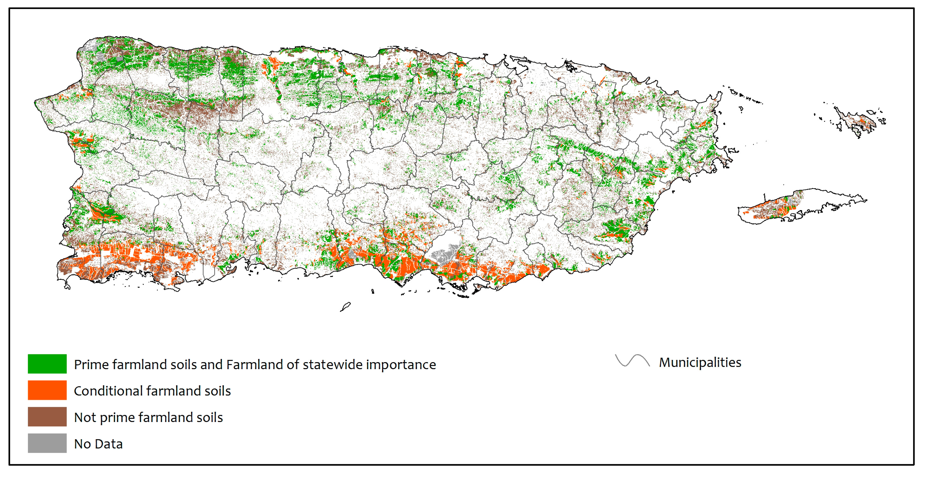
Figure 6.
Distribution of NRCS farmland soils that occur outside of lands characterized as well-suited to agriculture in this study.
Figure 6.
Distribution of NRCS farmland soils that occur outside of lands characterized as well-suited to agriculture in this study.

Figure 7.
The Puerto Rican landscape characterized by lands well-suited to conservation, agriculture, forestry, and development indicating current developed lands (13 percent); lands well-suited for conservation—including protected natural areas and riparian and reservoir buffers, subwatersheds surrounding reservoirs, wetlands, and barrens such as salt and mudflats, beaches, and water bodies (45 percent); lands well-suited for mechanized and non-mechanized agriculture—including row crops, livestock and dairy, hay and pasture, fruits, and other specialty crops (23 percent); and areas suitable for forestry production—including timber, non-timber forest products, agroforestry, livestock, shade coffee, apiculture, and agrotourism (19 percent).

Table 1.
Land classes well-suited to conservation, agriculture, and forestry, with developed land of Puerto Rico, excluding the protected islands of Mona, Monito, and Desecheo.
Table 1.
Land classes well-suited to conservation, agriculture, and forestry, with developed land of Puerto Rico, excluding the protected islands of Mona, Monito, and Desecheo.
| Land Class | Hectares | Percent |
|---|---|---|
| Well-suited to mechanized agriculture (<10% slope) | 124,187 | 14 |
| Well-suited to non-mechanized agriculture (10–20% slope) | 84,574 | 9 |
| Well-suited to forestry (20–50% slope) | 169,125 | 19 |
| Developed (built-up, artificial barrens and roads) | 115,859 | 13 |
| Well-suited to conservation | 399,673 | 45 |
| TOTAL | 893,418 | 100 |
Table 2.
Relative amounts of land cover types based on Gould et al. [22] within areas well-suited for mechanized and non-mechanized agriculture, forestry, and conservation for Puerto Rico.
Table 2.
Relative amounts of land cover types based on Gould et al. [22] within areas well-suited for mechanized and non-mechanized agriculture, forestry, and conservation for Puerto Rico.
| Mechanized Agriculture | Non-Mechanized Agriculture | Agriculture | Forestry | |||||||
|---|---|---|---|---|---|---|---|---|---|---|
| Land Cover | <10% Slope | 10–20% Slope | <20% Slope | 20–50% Slope | Conservation | |||||
| Classification [20] | Hectares | % of Total | Hectares | % of Total | Hectares | % of Total | Hectares | % of Total | Hectares | % of Total |
| Forest | 17,686 | 14 | 27,598 | 33 | 45,285 | 22 | 85,918 | 51 | 210,182 | 53 |
| Natural barren | 0 | 0 | 0 | 0 | 0 | 0 | 0 | 0 | 1063 | 0 |
| Grassland and agriculture | 93,219 | 75 | 42,657 | 50 | 135,876 | 65 | 53,679 | 32 | 87,281 | 22 |
| Woodland and shrubland | 12,948 | 10 | 14,264 | 17 | 27,212 | 13 | 29,493 | 17 | 58,224 | 15 |
| Forested wetlands | 0 | 0 | 0 | 0 | 0 | 0 | 0 | 0 | 8482 | 2 |
| Non-forested wetlands | 0 | 0 | 0 | 0 | 0 | 0 | 0 | 0 | 26,586 | 7 |
| Water | 66 | 0 | 0 | 0 | 66 | 0 | 0 | 0 | 7660 | 2 |
| TOTAL | 123,919 | 100 | 84,519 | 100 | 208,438 | 100 | 169,090 | 100 | 399,478 | 100 |
Table 3.
Relative amounts of land use categories based on the official Puerto Rico Land Use Plan [32] within areas well-suited for mechanized and non-mechanized agriculture, forestry, and conservation for Puerto Rico.
Table 3.
Relative amounts of land use categories based on the official Puerto Rico Land Use Plan [32] within areas well-suited for mechanized and non-mechanized agriculture, forestry, and conservation for Puerto Rico.
| Mechanized | Non-Mechanized | Combined | ||||||||
|---|---|---|---|---|---|---|---|---|---|---|
| Agriculture | Agriculture | Agriculture | Forestry | |||||||
| <10% Slope | 10–20% Slope | <20% Slope | 20–50% Slope | Conservation | ||||||
| Land Use Plan [32] | Hectares | % of Total | Hectares | % of Total | Hectares | % of Total | Hectares | % of Total | Hectares | % of Total |
| Water | 200 | 0 | 76 | 0 | 276 | 0 | 55 | 0 | 9478 | 2 |
| Specially protected rustic lands for agriculture or in combination with agriculture | 59,091 | 48 | 26,112 | 31 | 85,203 | 41 | 47,211 | 28 | 117,564 | 29 |
| Common rustic lands | 20,812 | 17 | 24,249 | 29 | 45,061 | 22 | 51,457 | 30 | 68,960 | 17 |
| Specially protected rustic lands for conservation, not agriculture | 18,830 | 15 | 22,370 | 26 | 41,200 | 20 | 59,190 | 35 | 184,102 | 46 |
| Potential urban | 1522 | 1 | 1141 | 1 | 2662 | 1 | 1759 | 1 | 2033 | 1 |
| Urban, not necessarily built | 23,590 | 19 | 10,608 | 13 | 34,197 | 16 | 9445 | 6 | 17,533 | 4 |
| TOTAL | 124,044 | 100 | 84,556 | 100 | 208,600 | 100 | 169,116 | 100 | 399,671 | 100 |
© 2017 by the authors. Licensee MDPI, Basel, Switzerland. This article is an open access article distributed under the terms and conditions of the Creative Commons Attribution (CC BY) license (http://creativecommons.org/licenses/by/4.0/).
Share and Cite
MDPI and ACS Style
Gould, W.A.; Wadsworth, F.H.; Quiñones, M.; Fain, S.J.; Álvarez-Berríos, N.L. Land Use, Conservation, Forestry, and Agriculture in Puerto Rico. Forests 2017, 8, 242. https://doi.org/10.3390/f8070242
AMA Style
Gould WA, Wadsworth FH, Quiñones M, Fain SJ, Álvarez-Berríos NL. Land Use, Conservation, Forestry, and Agriculture in Puerto Rico. Forests. 2017; 8(7):242. https://doi.org/10.3390/f8070242
Chicago/Turabian StyleGould, William A., Frank H. Wadsworth, Maya Quiñones, Stephen J. Fain, and Nora L. Álvarez-Berríos. 2017. "Land Use, Conservation, Forestry, and Agriculture in Puerto Rico" Forests 8, no. 7: 242. https://doi.org/10.3390/f8070242
Note that from the first issue of 2016, this journal uses article numbers instead of page numbers. See further details here.