1. Introduction
Spatial conceptualisation is a difficult construct that many struggle with [
1]. The mere suggestion of visualizing a spatial location is enough to cause anxiety to students and professionals alike, in the social sciences and in some natural sciences as well. Online maps, GPS devices and smart technology have now been around since the late-1990s such that the university generation, having been born in the early 1990s, and the subsequent generation, now in their secondary years, which have been exposed to these virtual tools to the extent that their spatial-knowledge should be wide-ranging. This may not always necessarily be the case, however. Furthermore, there are also other generations to consider, who may or may not be conversant with a different reality, away from the real space one. Indeed, access to virtual environments in Malta in 2010 was still at 38.4% for older generations as opposed to 97% for the younger generations [
2], with 72% of the older generations not comfortable with using virtual places, even simple interactive maps, as against the younger generations’ parametric use of online maps, role-playing games and immersive places [
3]. In a world where dependence on paper maps and physical documentation is slowly giving way to virtualization, those with potentially less knowledge of the virtual world could experience new disadvantages. To be able to effectively tackle this issue, a clear understanding of the spatial-awareness of people is required. In order to understand how such a spatial awareness can be achieved, a project was taken up in the Maltese Islands aimed at creating a process to generate a virtuality of the islands as a preparatory step for a long-term study on virtual social-interactionism and the cognition of space.
1.1. Need for Knowledge Transfer from Real to Virtual Spaces
The concept of place is a highly interesting one in that it can be used to understand how far persons are aware of their surroundings, both as a location, in terms of xy coordinates, as well as in terms of knowledge of the world they live in. As increased periods are being spent online in real terms, particularly by the younger generations, a new paradigm is required, that ensures that the knowledge of the physical world is not totally lost on the younger generation. The same paradigm needs to also ensure that the older generations can identify the concept of place in the new virtual space, through increased use of virtual environments. Indeed, this new paradigm needs to ensure that the physical knowledge gain is transported to the virtual domain for preservation and access to information on the real world. It must also enable knowledge dissemination through diverse conveyors as are online maps, immersive worlds and game engines. In such a scenario, the two-opposite lost generations’ knowledge can be employed for such activities as educational enhancement, scenario building and preparedness for such events as post-disaster, technology shutdown, development planning, and environmental protection.
1.2. The Scope
The project scope is a long-term one and, whilst aimed at understanding the level of knowledge of one’s cognition of space, it is primarily targeted to identify those tools that could be employed to study such phenomena as neogeographic poverty, and to identify which tool is readily available for future analytical steps. In effect, this study reviews the steps taken in the Maltese Islands to prepare the ground data and infrastructure for a long-term study of spatial cognition within a virtual environment. The paper reviews the issues that impact on cognition in such virtual environments and investigates those steps that need to be taken to ensure the transition of the information from real to virtual space. The project will eventually bring on board players, who will interact in an online world, by being involved in a participant-observation study where experts from various social/psychological/technological disciplines will observe them from a distance, through various methodologies. The latter will include the classical anthropologists method of uncontrolled-naturalistic observation, interaction at sporadic intervals through an observer as participant approach and even the new form of online observation called spectating where researchers partake to the players’ immersive viewpoints.
The paper looks at the literature that calls for such studies and the legislative and operational requirements which call for knowledge on data, its gathering and use for societal change. It then looks at the process taken up in the Maltese Islands to prepare for a scenario where users can interact with the data in a 3D virtual world that would allow for such a social-interactivity study to be carried out. The tools employed are depicted and the preparatory world developed (a basic world reflecting the real environment).
2. Knowledge of One’s Geographic and Social-Spatial Realities
Cognition and space have been studied for decades in a 2D reality, particularly their impact on interactivity and knowledge of one’s spatial surrounding, and the inherent interactivity with others in such spaces. Whilst Giddens [
4], Ekblom [
5], and Tufte [
6] pointed towards the study of interactions as based on the analysis of social practices ordered across space and time in the wider society, others, such as Harries [
7] and Haining [
8], looked at micro-environments where these interactivities have their own “ecologies of space”. Virtual space sits in entirely new domains; however, the interactions of the different generations within these spaces follow paths that initially mimic the real world they are conversant with. These may become increasingly alienated however, as the younger generations prefer to investigate new environments as against virtual rendition of known spaces. Cosgrove [
9], Lynch [
10], and Bishop’s [
11] depiction of cartography as a method of social and geographical control is the currently most adopted foundation test for the mapping of new cartographies that may be implemented in the new domains of the virtual worlds.
3. Identifying Legislative and Operational Requirements
The initial steps in the preliminary study were aimed at identifying modes of baseline data capture, which were eventually enhanced through the creation of integrated and open data for the eventual porting to online virtual worlds. Identifying these modes of baseline data capture was made possible through an analysis of the Maltese state of affairs of access to data, harmonized datasets and validated data. In this regard, the project identified that the Maltese development of virtual environments aims at employing remote sensing technology. The first base maps were created in the late 1980s, which were followed by a surge of spatial information related to thematic activities in the 1990s, and the eventual implementation of spatial information at the analytical stage during the 2000s. The Maltese EU accession in 2004 resulted in the need for analytical and modeling progress in the fields of planning and, more vitally, environment protection, the latter requiring a large take-up of EU
acquis requirements. This spatial-related technology and analytical process has now matured such that what is now considered necessary are efforts focused on the societal benefits as identified by the GEO initiatives [
12] listed below:
- (1)
Reducing loss of life and property from natural and human-induced disasters;
- (2)
Understanding environmental factors affecting human health and well-being;
- (3)
Improving management of energy resources;
- (4)
Understanding, assessing, predicting, mitigating, and adapting to climate variability and change;
- (5)
Improving water resource management through better understanding of the water cycle;
- (6)
Improving weather information, forecasting and warning;
- (7)
Improving the management and protection of terrestrial, coastal and marine ecosystems;
- (8)
Supporting sustainable agriculture and combating desertification; and
- (9)
Understanding, monitoring and conserving biodiversity.
In order to implement the changes above, the state has to have an educated populace that understands data in space and time, which, if not available, should be developed in order to disseminate locational knowledge, and to lay the baseline for scenario-building. Malta’s early work sought to mitigate the barriers to access to data, high charging costs, and data currency. Pre-EU accession projects aimed at improving Malta’s capacity in relation to the implementation of the Aarhus Convention [
13], the Infrastructure for Spatial Information in the European Community (INSPIRE) Directive [
14], the Freedom of Information Act [
15], the Public Access to Information Act [
16], and the Shared Environmental Information System [
17]. However, the relative projects, whilst serving as consumables for the professional and academic domains, were of little help to the public at large. Tools were required to help the general public to access the data and primarily to create a set of baseline data that would fuel that same access, however, such access was still developed in 2D format and interaction with the actual data by the public was not possible. The new possibilities to interact with the same data in virtual environments required the setting up of infrastructures that enable the creation of a 3D environment, one which would allow the study of interactionism between the players, their known environment and reaction to unknown or new spaces within the virtual worlds.
4. The Conveyor to Data Acquisition
The steps taken to acquire baseline data was made through a project co-financed by the European Regional Development Fund entitled Developing
National Environmental Monitoring Infrastructure and Capacity (ERDF156) [
18], which project involved the monitoring of air, water, soil, radiation and noise, and 3D terrestrial and bathymetric surveys.
This project ensured that a new set of baseline data capturing exercises across the different themes was developed. Terrestrial and bathymetric data were made available at higher resolutions suitable for environmental modeling and EU reporting purposes. As the non-availability of high quality 3D spatial data hinders comprehensive land use planning and environmental monitoring, the project delivered a series of scans using different technologies in order to provide a comprehensive seamless dataset. The delivery included: High resolution 3D terrestrial data coverage for the Maltese Islands using a combination of oblique aerial imagery and Light Detection and Ranging (LIDAR) data; and a bathymetric survey of coastal waters within one nautical mile (nm) radius off the baseline coastline, using a combination of aerial LIDAR surveys, acoustic scans and a physical grab sampling survey as well as GIS-based noise maps. Furthermore, the foundation for the future examination of the multi-thematic analysis was laid through the acquisition of tools and the delivery of outputs as follows:
- (1)
LIDAR Scan: Terrestrial (Topographic Light Detection and Ranging [LIDAR]) Digital Surface Model (DSM) and Digital Terrain Model (DTM) (316 km2);
- (2)
Bathymetric LIDAR aerial survey-depths of 0 m to 15 m within 1 nautical mile from the Maltese coastline (38 km2);
- (3)
Bathymetric Scan: Acoustic (side scan sonar) Digital Surface Model and an acoustic information map of sea bed (361 km2);
- (4)
High resolution oblique aerial imagery and derived orthophoto mosaic and tiled imagery of the Maltese Islands (316 km2);
- (5)
Satellite imagery (GeoEye, RapidEye, Quickbird) (316 km2);
- (6)
Remote GPS Cameras (Remote capture GPS receiver);
- (7)
3D scanner and 3D printer;
- (8)
GIS Handhelds for field surveys; and
- (9)
Global Navigation Satellite System Station.
This is the first time in recent history that a LIDAR scan, as well as a full bathymetric survey was carried out for all the Maltese terrestrial areas and coastal waters. Whilst various terrestrial exercises were carried out for development planning purposes, bathymetric surveys were only carried out for specific projects and research work, such that they were ad hoc, highly localized and with no adherence to any standard methodologies. Following a review of the emerging technologies, the mapping of the seabed topography at high resolutions for such a large area was deemed essential and the results provided the Maltese Islands with a comprehensive and updated database on sea depths. Furthermore, mapping the terrestrial and seabed topography has various applications. It provides a basemap from which various environmental studies can be carried out. These include studies as required by the Corine Landcover Initiative, the Water Framework Directive and the Marine Strategy Framework Directive. It also serves as a tool for impact analysis of development planning, pollution and chemical prediction modeling, climate change monitoring as well as render recognition of features. In addition, it allows thematic experts to study, monitor, analyze, and protect those areas that are vulnerable to degradation and exposure. Useful information that can also be extracted from the results includes updated nautical charts, viewshed analysis and cross-thematic studies in the physical, social and environmental domains. Terrestrial and seabed topography mapping also provides the required baseline for pushing data to the lost generations through the provision of this data in a real-time scenario.
The 3D aerial surveys using LIDAR technology surveys were carried out in order to generate digital terrain 3D models which can be used for various applications such as urban and transport planning, environmental impact assessments, modeling of runoff water, monitoring of and enforcement of land use activities. The terrain 3D models and the sea bottom 3D models from the ERDF project are being merged to form an innovative integrated 3D perspective for the Maltese Islands.
All data from this project was also planned to be made viewable from a web portal, known as a Shared Environmental Information System (SEIS) [
19]. The SEIS system serves as the dissemination portal for the domains of air, water, noise, radiation and soil, as well as digital elevation models, digital surface models and the aerial imagery.
Interestingly, this project is innovative in the fact that it also acted as a main facilitator for the implementation of the data component of a number of international directives and it ensured the delivery of one factor that has hindered virtuality research; that related to the free delivery of all project data to the general public. The latter has brought together the requirements as outlined by the Commission’s Communication COM (2008) 46 Final “Towards a Shared Environmental Information System”, the INSPIRE Directive (Directive 2007/2/EC) and the Aarhus Convention.
This completed, the next step was to identify the potential to use this output as the launching pad for the dissemination of data that allows for the increase in spatial awareness-the scope of this project.
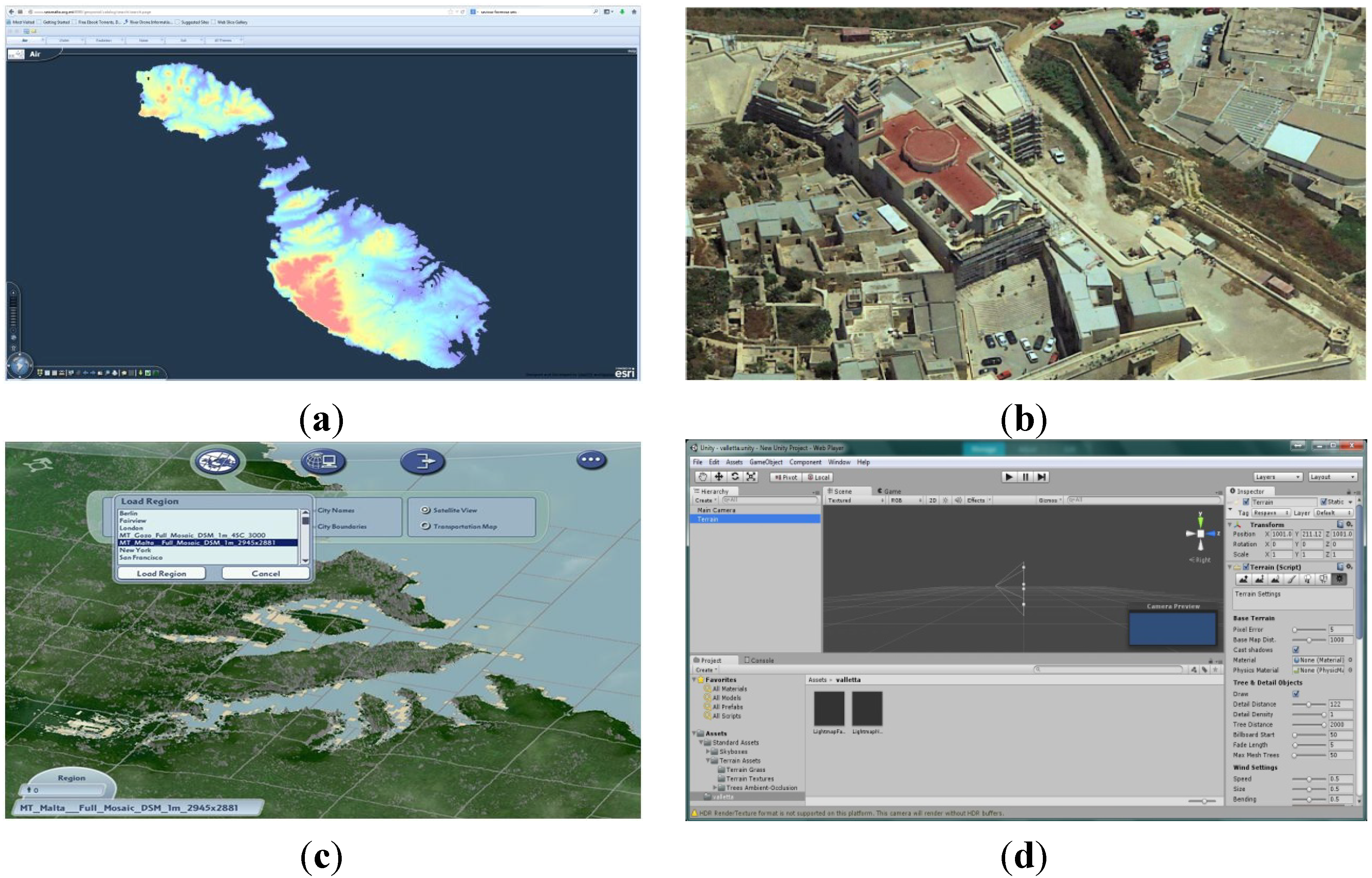
5. Results and Outputs
The project to acquire the base LIDAR data was concluded in 2012 and an entire terrestrial data set was created through the GIS integration of 554 data sheets each of a 1 km × 1 km area (
Figure 1a). The data was subsequently converted to a dem employing ArcGIS 10.1 with a height map resulting from a thematic analysis (
Figure 1b). Further detailed analysis was made as based on the generation of a raster map at a resolution of 25 cm per pixel (
Figure 1c), which resulted in a 90 Gb file and a 10 cm resolution resulting in a 263 Gb file. Reviewing the data in 3D through ArcScene, to an extent helped the recognition process through the simple use of monochrome LIDAR height points (
Figure 1d); however this process is a heavy one and requires massive processing power.
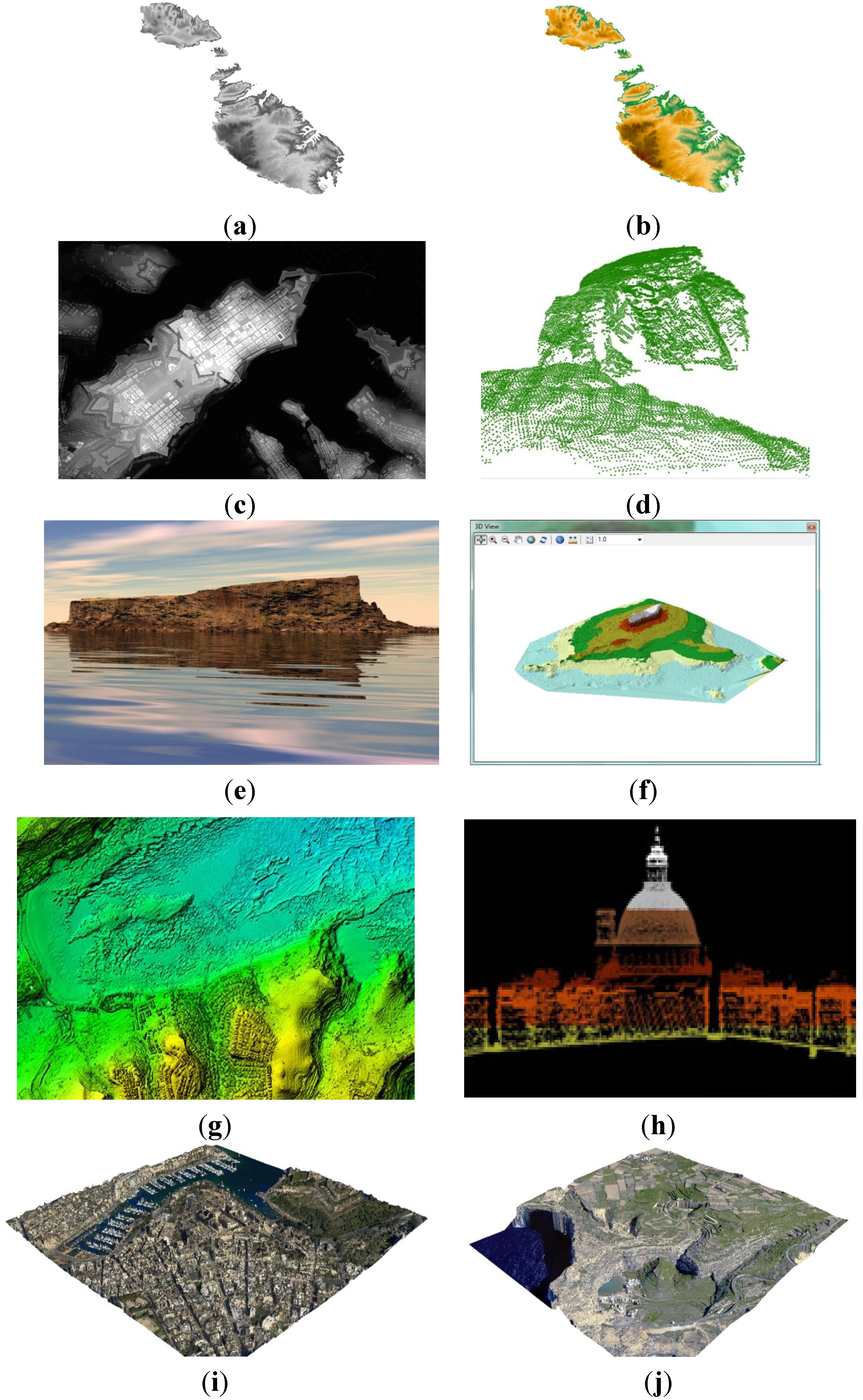
Figure 1.
(a) Terrestrial LIDAR data integration; (b) height map based on LIDAR data; (c) Valletta 25 cm raster output; (d) Dwejra LIDAR Points; (e) Filfla rendering; (f) Filfla terrestrial and bathymetric data aggregation; (g) Mellieħa Height-Depth map; (h) Valletta LIDAR cross-sectional perspective; (i) Pieta VRML output from tin and ortho-imagery; (j) 3d-printed Dwejra haptic output.
Whilst at this stage, most results are still difficult to comprehend to non-experts due to the limited knowledge of the geographical and GIS background behind such outputs, awareness is better served with a 3D rendering using Corel Bryce 7 software (
Figure 1e), which renders the spatial points into a physical structure that is instantly recognizable. Interestingly, even when an integrated terrestrial and bathymetric depiction is made (
Figure 1f) recognition is still high, mainly due to the unique shape of the small Maltese island of Filfla, which is situated to the southwest of the main island, which island was used as an example. This process resulted in mixed reactions. For example the employment of a homogenous color scheme to the terrestrial and underwater zones created a top-down view of the locality of Mellieha which was unclear to many (
Figure 1g). The particular shape in this case misled both experts and novices in that the terrestrial section resembled the walled cities in the Grand Harbor and such was the natural choice of the reviewers due to cognition of known spaces. It is only when the beach to the Northwest of the image was highlighted that recognition was elicited as landmarks became easily identified. This highlighted the need to provide landmark points to help in the identification of positional familiarity. The usefulness of landmarks was verified through the instant recognition, by users, of the Valletta Carmelite Dome depicted in
Figure 1h that employed a multi-color cross-sectional analysis of the LIDAR points.
This process was taken further through the outputs resultant from VRML (Virtual Reality Modelling Language) depiction (
Figure 1i), that allows for virtual insertion in known spaces such as the instantly recognizable hospital and marina adjacent to the medieval fortifications. Immersions, apart from helping identification of landmarks, initiate the process of the physical to the virtual environments, even if not allowing manipulation of the data.
Finally, this phase was concluded with the introduction of a haptic approach resultant from the ERDF project which enabled the 3D printing of the VRML model (
Figure 1j that depicts the Gozitan inland sea area of Dwejra).
The next step describes the process investigated to create middle-state data for eventual conversion of the raster maps into 3D immersive environments, which against the VRML model, allow for interaction and manipulation of the virtual place.
6. Conversion from Known to Unknown Space
6.1. Points to Blocks
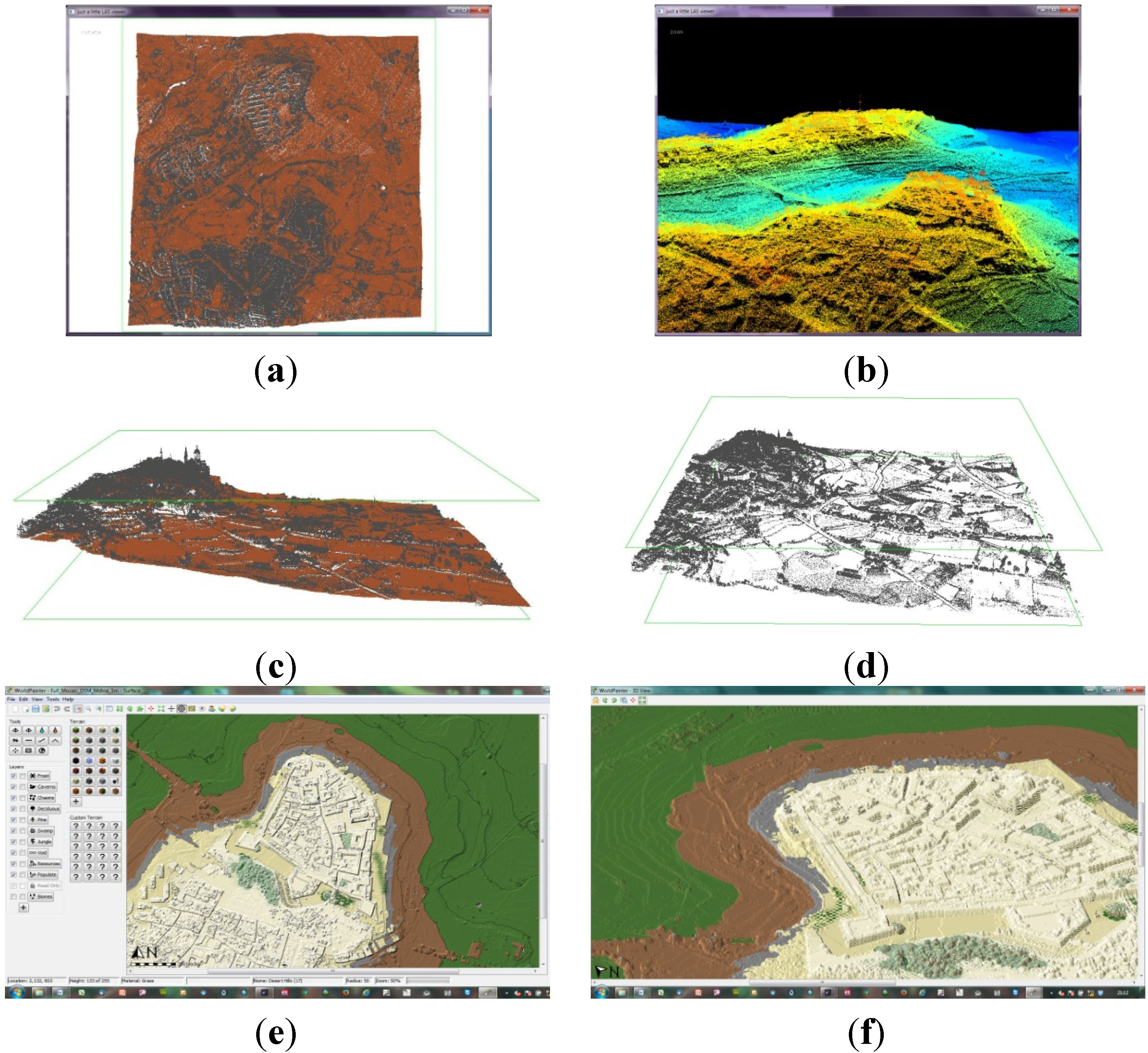
Preparing for the potential creation of an interactive 3D model of the islands entailed a process that ensured the conversion of LIDAR data from points viewed in a top-down approach (
Figure 2a), to a series of perspective views depicted in different colors that help viewers to identify unique landmarks through the Lastools software (
Figure 2b–d). Once the area was chosen, the next step entailed exporting to a raster map at the required resolution, that of 10 m, 1 m, or 25 cm, respectively. Another intermediary step was required to convert the data to the immersive environment, which was employed through the use of a tool (Worldpainter) that converts the height map into a world environment. This was employed at the later stages of the process.
Figure 2e-f show the top-down and oblique perspectives respectively, where each pixel was given a block structure as against the original flat 2D structure.
Figure 2.
Initial Conversion steps (a) Mdina sheets integration in LasTools; (b) height map testing identifying comparative perspective for eventual immersive testing; (c) Mdina side perspective; (d) infrastructural outputs for post-conversion comparison; (e) Mdina conversion to Worldpainter; (f) Mdina Worldpainter 3D perspective.
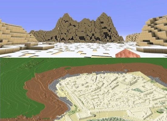
6.2. The Miner’s Dream
The final phase entailed the decision to employ a tool that is readily available, is immersive, of low cost and has a shallow learning curve. Whilst various tools are available for this purpose, few have been identified that exhibit all three parameters, with one exception: That called Minecraft. More vital, as against the other visualization applications, the tool costs a mere €20, easily affordable by those whose lack of access to tools and data have been termed the new poor; and those who have little access to such knowledge due to limited funds and bandwidth. In this case, the application provides an environment that fits the need of this exercise and is based on a game-engine that allows for the manipulation and alteration of the surroundings. Users can alter landscapes, build towns and interact in the new environment based on a collaborative or survival concept.
No longer depicted as a simple visualization tool, the physics and sense of perspective allowed for a sense of reality of real space, whilst allowing users to recognize landmarks and help build scenarios for interactive activities, landmark building, and predictive analysis.
Figure 3 depicts the result of the
Figure 2 conversion from a 2D environment into a 3D one where users can move within the Mdina zone without the need for hi-end GI software or hi-spec technologies. The area was spliced into 4 Mb areas that are easily downloaded even through low bandwidth and older computers.
Figure 3a,b depict the coordinates of the virtual avatar’s location in a day-time/night-time interactive period. Users are able to move around the world, walking or flying (
Figure 3c–f) in similar modes to the earlier VRML models, with added functionality where they can manipulate their environment to the extent of demolition or erecting developments, planting trees and flooding areas.
Interestingly, the higher the resolution, the closer to reality the world becomes, with proportionality reflecting the real physical world. Whilst the 10 m per pixel world generated an island that could be walked across in 10 min (assuming a constant flying rate that sheds tiredness and body constraints), the 1 m version takes 40 min, whilst the 25 cm version takes all day, it reflecting the same parameters as the real world. The latter is highly useful to users as they can immediately identify those areas they are conversant with in the physical world, in turn enhancing their knowledge of the virtual world. In contrast, the younger cohorts had a virtual immersive map of the island they physically live in but increasingly rarely interact with. With the potential for economic activities being ported to the virtual environment, the study of social wellbeing for the younger generations is essential with researchers and policy-makers being required to take on board the virtual worlds in order to understand their subject’s relationship to virtuality, and their knowledge of real space.
A post-render test was carried out as a pilot study to investigate if the Minecraft output allows for better recognition of the virtual space as related to real space. Users were allowed to walk around the 3D map and to describe the locations they visualized in terms of real space. A pilot group of 15 persons spread across the generations were allowed to roam the map for 30 min and asked to identify locations and/or landmarks. The outputs indicated that users in both generations could interact with the same environments they live in and identified their surroundings quicker once they were following a pre-made environment, such as the Minecraft Maltese Islands. This was increasingly true for the older generations, where they quickly identified zones as the power station, the medieval walled cities and the main churches, interestingly through the use of a zooming in option from the smaller to the larger scale. Indeed, especially for the older generation, their skepticism or fear of interaction with a 3D virtuality was overcome following the recognition of the digital space as the physical space they interact with on a daily basis. This said, the limitations on usage of the technologies by the older generation, as identified by the National Statistics Office in their ICT [
1] and users’ survey [
2], is evident through their need to spend time focused on familiarizing themselves with the technology and its usage. The younger generations sought to identify locations through the visualization of the coastal boundary and such recognizable locations as sports grounds or the lesser islands. The pilot study outcomes highlighted the need to investigate further those elements of interaction that would be studied in the main project: Who, why, when, where, what, and how.
Figure 3.
Minecraft virtual space engine results for the walled citadel of Mdina (a) coordinate analysis-Day-time simulation; (b) coordinate analysis-Night-time simulation; (c) 1 m block conversion output–side perspective; (d) 1 m block conversion output–top perspective; (e) main square aerial view; (f) main square walkabout view.
6.4. Taking the Next Steps
The positive outcome of this study has been taken further, via an attempt to integrate the outputs of this pilot project into other applications, as well as the porting of the SEIS portal’s environmental data to the virtual world (
Figure 4a). Furthermore the integration of aerial imagery and the oblique imagery are currently being sought to enable the enhancement of the data to reflect the real world (
Figure 4b). Whilst the above are at an embryonic stage, another two game technologies will be employed in the future to allow alternative options for interactive exercises. The age-old SimCity series has been taken to new heights with the option to integrate real-world maps, herein converted from LIDAR, to raster, to SimCity region (
Figure 4c). Finally, the next phase would see the integration of the datasets within Unity3D (
Figure 4d), which offers vistas for deeper interactivity and high-end rendering options.
Figure 4.
Next steps for the dissemination of the data to professionals and the younger generations (a) SEIS interface; (b) conversion to the main online servers (GoogleEarth); (c) simcity conversion for planners; (d) unity for gamers and educators.
Figure 4.
Next steps for the dissemination of the data to professionals and the younger generations (a) SEIS interface; (b) conversion to the main online servers (GoogleEarth); (c) simcity conversion for planners; (d) unity for gamers and educators.
Once these worlds are built, a full-scale study of the different generations will be carried out aimed at understanding the interactions with the environment, with other persons, as well as with data emanating from the new web services being created for the requirements of the INSPIRE Directive. At that stage, planners, environmental experts and policy makers would be introduced to the virtual worlds to experience scenarios resulting from the different policy-making options, and to investigate scenario-building for policy-testing before the actual implementation in the real world.
7. Conclusions
Access to the web and instant information has not necessarily expanded one’s knowledge of place, whilst aiding the creation of new forms of poverty-those linked to access to information and the loss of an opportunity to understand neo-geographical realities [
1,
2]. This study helped to show that familiarization with real space is possible and that the identification of access abilities by different generations requires further studies with a larger sample. Nonetheless, an interesting outcome was the fact that both generations expressed forms of take up of virtual space interaction despite the fact that the access issues are yet to be tackled. The ERDF project sought to reduce this lack of access through the provision of online data, however the next phase is required, that which allows users to interact with the data. The ERDF project enabled the review of the legislative and operational requirements, which call for knowledge on data and its gathering, particularly through its use of the SEIS process and the eventual geoserver. The spatial development entity and the environmental department of the Maltese Islands have already sought to take up the results of the project to submit their input in relation to plans such as the Strategic Plan for the Environment and Development (SPED), which tackles current and predictive scenarios of societal change resulting from land-use inherent policies [
20].
The construction and porting of virtual environments based on real-world information enables the knowledge gain and transfers between the generations to ensure transference of social interactive spaces and phenomena, otherwise lost between the two different realities experienced by the disparate generations. Low cost and accessible tools are enabling the creation of knowledge transfer processes before the older-generation legacy is lost, thus, allowing their knowledge of place, embedded in real space, to be transferred to the virtual one.
This first-phase project enabled the setting up of virtual worlds that serve as the foundation for the next-phase were users/players will participate in a neogeographic form of anthropological study, which investigates their knowledge of the digital replication of their country, landmarks, their social interactions and eventual psychological, social and environmental interactions with the new world. In turn, such a study would allow for the investigation of an increase in the cognition of known real space, new methods of social interactions through avatars, and also the changes rendered to the environment to fit the new societal structures.


