1. Introduction
The city of Jerusalem has had a long occupation history, which started in the Chalcolithic period (4500–3200 B.C.) until the present time. Jerusalem is considered a perfect place for archaeologists and water engineers to study ancient water systems. Previous archaeological and historical studies tried to answer the chronological questions related to biblical fictions, and there is little focus on the landscape setting of the ancient water systems [
1]. Hopefully, the landscape setting of the ancient water systems in Jerusalem might have an effective role in the near future in understanding the technical design, construction and functional aspects of Jerusalem’s ancient water systems. The behavior of the ordinary societies that lived alongside of ancient water systems of Jerusalem through the course of time is not well explored. For example, Angelakis and Koutsoyiannis [
2] reported that ancient Greek livelihood improvements and significant cultural developments were based on innovative technologies to collect, store, and transport water, as well as legislation and institutions to effectively manage the available water resources.
A thorough understanding of the ancient water systems in Jerusalem calls for categorization and should be based on the landscape setting, water resources and their technical function. The aim of this article is to review the various ancient water systems in Jerusalem, including the underground water system, the water harvesting pools, and the aqueduct systems. Archaeological evidences and landscape settings were applied utilizing all available and accessible literature relevant to the ancient water resources management in Jerusalem.
2. Water Resources Management during the Bronze and Iron Ages
Many archaeological excavations and surveys undertaken in the Jerusalem area since 1867 such as those of Warren, Parker (1909–1911), Kenyon (1961–67), and Shiloh (1978–84) have revealed that an underground water system was the first water supply technology in Jerusalem [
3]. Recent excavations carried out by Reich and Shukron during 1995 [
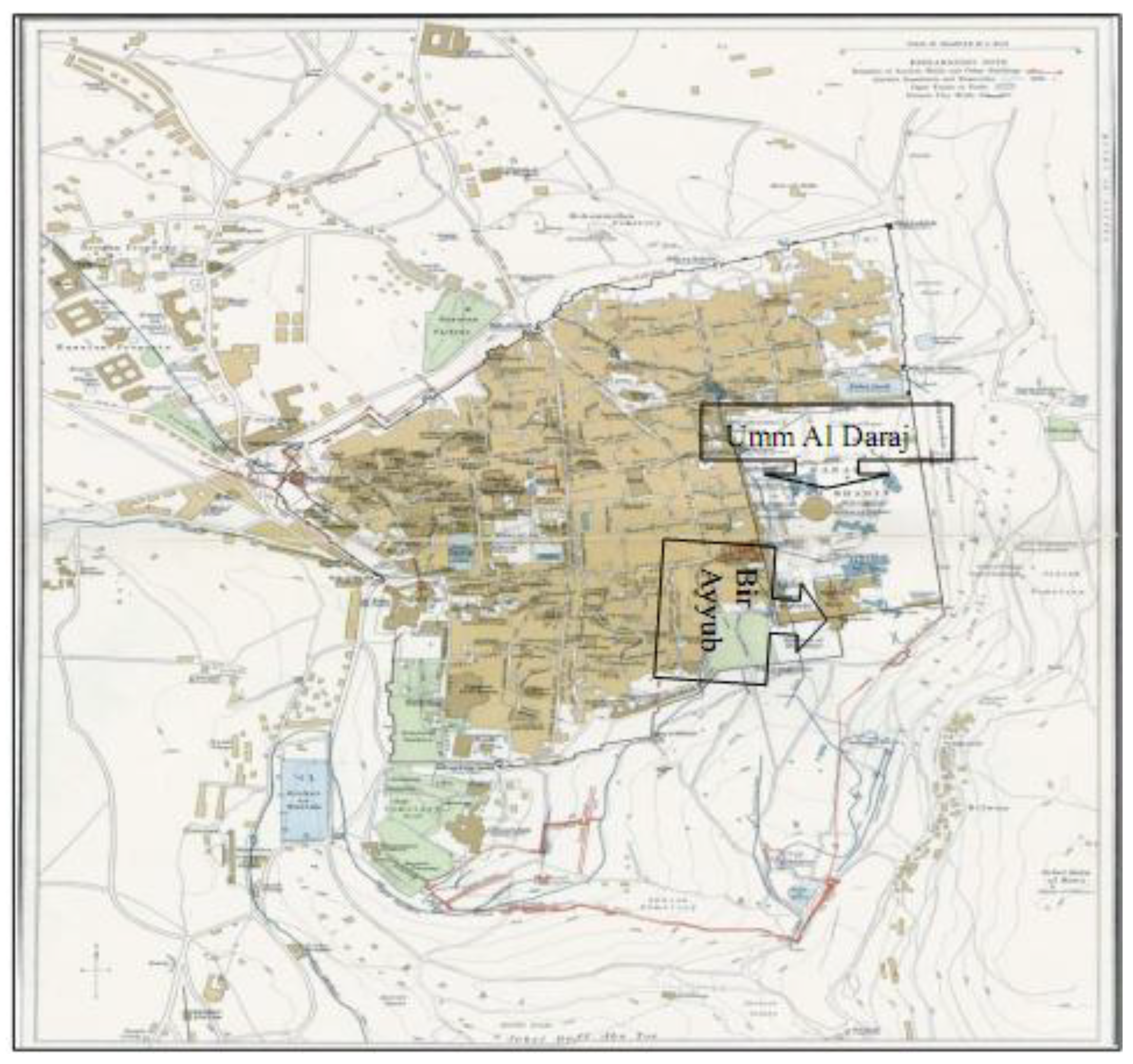
4] contributed to the discovery of the details of the system’s structure. Within the area of settlement of Jerusalem at Tell Abu Ed-Duhur during the Bronze and Iron Ages, there were two springs, the Umm Al Daraj and Bir Ayyub springs. Both of them are located topographically at the bottom of Wadi Sitti Miriam (a wadi is a small seasonal stream), which is located east of the present Jerusalem wall (
Figure 1). According to Kenyon [
3], the springs’ location, especially that of Umm Al Daraj, determined the landscape setting of the urban settlement of Jerusalem city during the middle Bronze Age (2000–1500 B.C.).
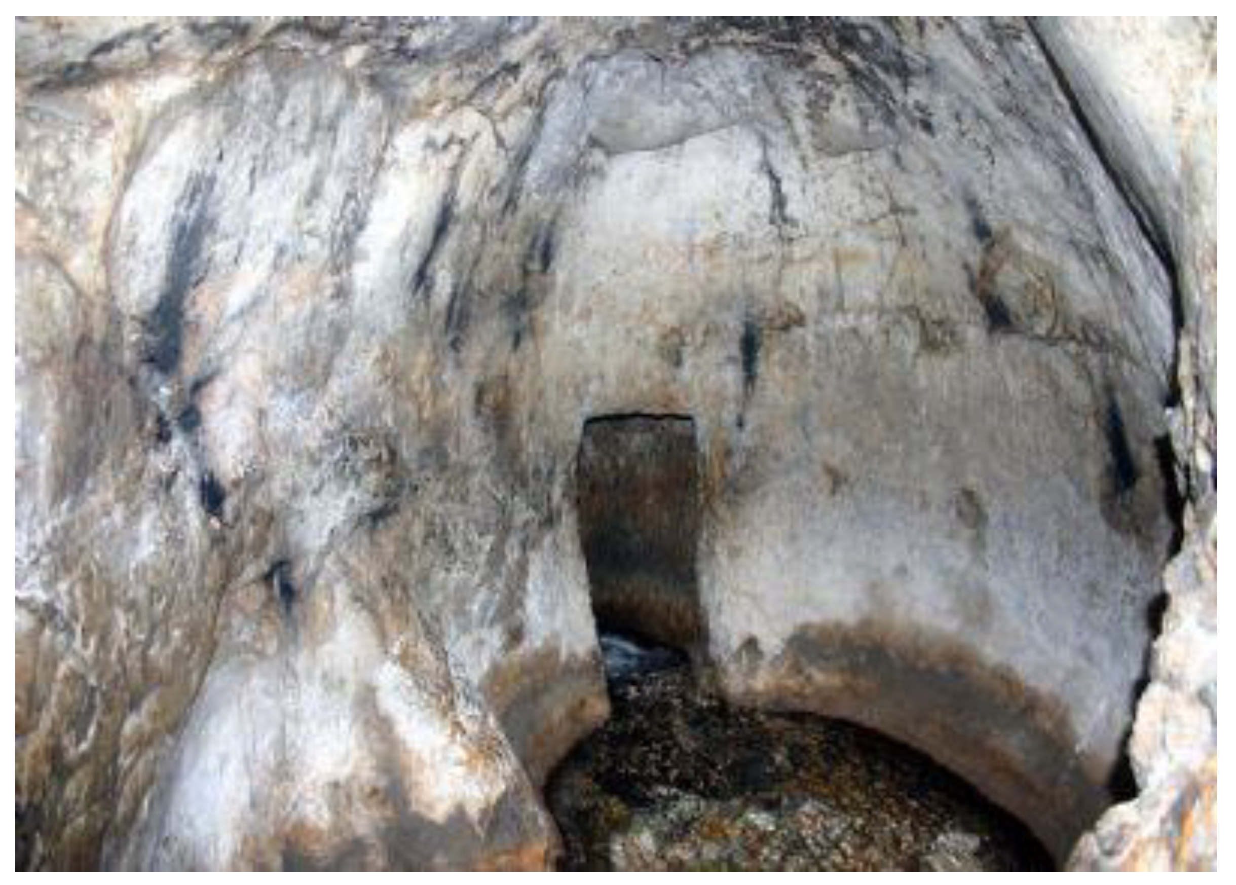
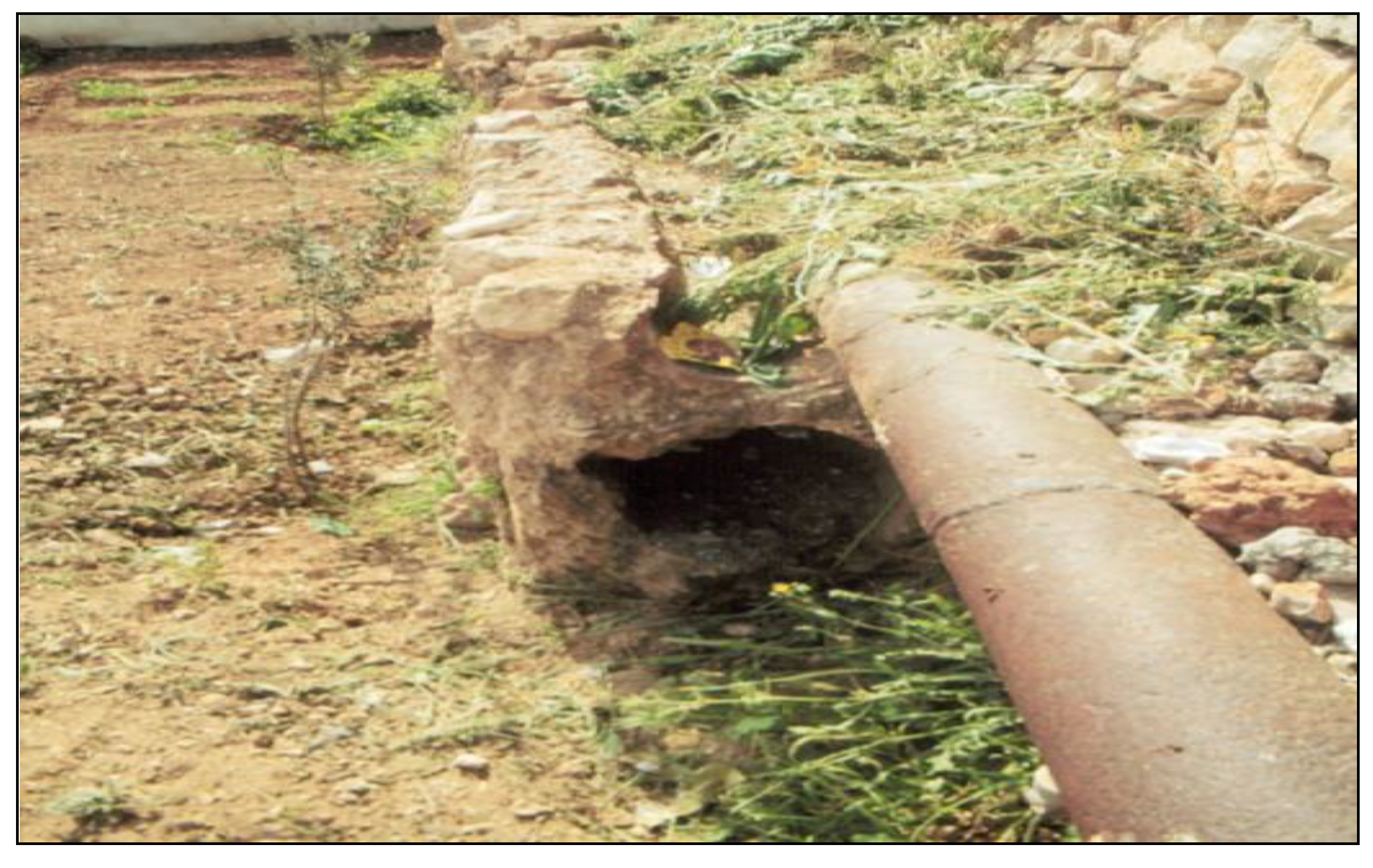
Ain Um Al Daraj (
Figure 2 and
Figure 3) consists of a natural cave where the entrance of the cave is made of rock steps, maybe constructed sometime in the middle Bronze Age. Hence, the local people of Silwan village gave it the Arabic name “Ain Um Al Daraj”, which means the spring of (with) mother steps [
5]. Archaeologically, this spring was used before the time of the Middle Bronze Age city to irrigate the agricultural fields located in the Wadi. The archaeological evidence from excavations [
5] in the Wadi show there are shards of pottery and structures dating back to the Early Bronze Age (3200–2000 B.C.).
Figure 1.
Map of Jerusalem city with overview on Umm Al Daraj and Bir Ayyub springs.
Figure 1.
Map of Jerusalem city with overview on Umm Al Daraj and Bir Ayyub springs.
The morphological evidence in the Wadi indicates that the original Wadi surface was about 0.1 m below the current Wadi surface. This was explained by Reich and Shukron [
5] due to agricultural activities conducted along the Wadi course during that era.
Figure 2.
Structural view of Ain Um Al Daraj spring.
Figure 2.
Structural view of Ain Um Al Daraj spring.
The archaeological evidences from the different excavations in the area of the settlement of Jerusalem at Tell Abu Ed-Duhur [
3] show the erection of the first fortification wall of Jerusalem city during the Middle Bronze Age. This reflects the re-urbanization process in Palestine during the Middle Bronze Age, which occurred after the collapse of the urban centers at the end of the early Bronze Age (
Figure 3).
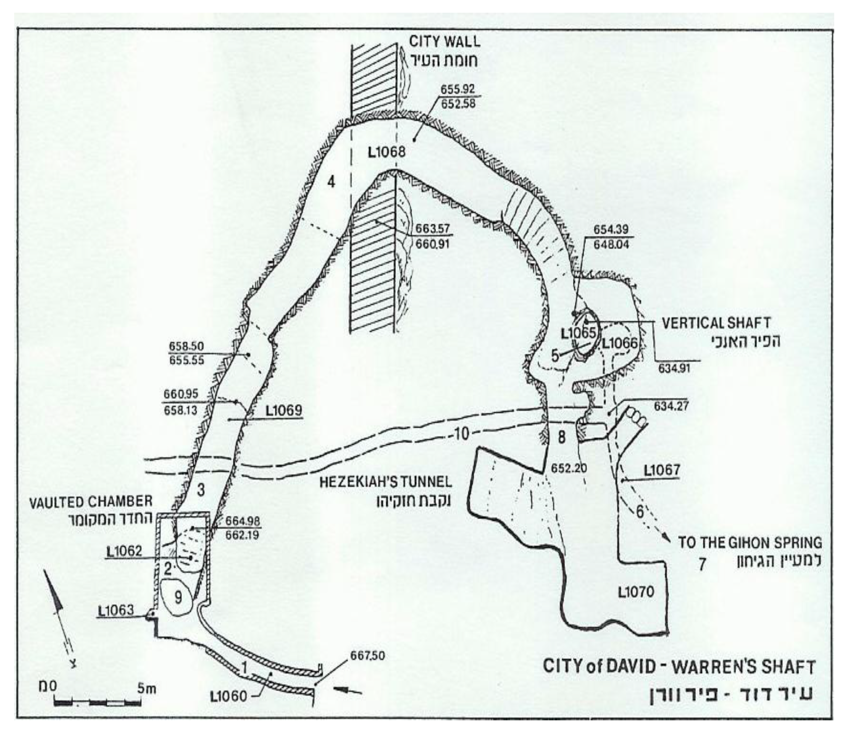
Figure 3.
Underground water structures during the Middle Bronze Age. From [
6].
Figure 3.
Underground water structures during the Middle Bronze Age. From [
6].
Technically, according to researchers, the construction of the underground water system in the Middle Bronze Age in Jerusalem was a technical solution to link the water resources from the Um Al Daraj cave with the Middle Bronze Age city wall of Jerusalem. Basically, the underground system consisted of ten structures as shown in
Figure 3. These included the Warren shaft, access tunnel, vaulted chamber, stepped tunnel, horizontal tunnel, vertical tunnel linking to spring, Um Al Daraj cave, side cave, trial shaft, and Hezekiah’s tunnel [
6].
Many interpretations were made by archaeologists to give reasons for the construction of the underground water system; most scholars have been proposed security reasons,
i.e., people could thus protect water resources by the construction of an underground system during periods of unrest. [
4,
6].
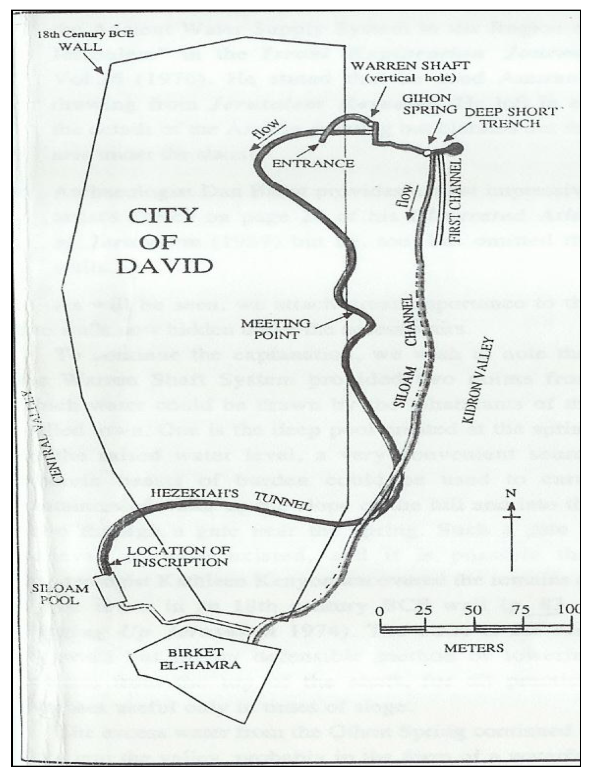
During the Iron Age (1200–538 B.C.), many water installations were constructed in Wadi Sitti Miriam (Mary), especially in the vicinity of the underground water system. The function of the water installations in Wadi Sitti Miriam was most likely to convey the water through irrigation systems into the southern part of the Wadi in order to irrigate the agricultural fields.
Figure 4 shows the important irrigation systems developed during the Iron Age including the Siloam Channel (Qanat Silwan) and Silwan Tunnel (Hezekaih’s tunnel). Qanat Silwan is located about three meters above the Um Al Daraj spring. The archaeological evidence at Um Al Daraj spring shows a higher damming wall that was used in the past to (hydraulically) raise the water from the Um Al Daraj spring into the Silwan channel. The length of Qanat Silwan is about 400 m and it conveyed water through Wadi Sitti Miriam into the Birket Al-Hamra (Al-Hamra pool). The total area of the pool is 2,562 m
2 [
7].
Figure 4.
Qanat Silwan and Silwan tunnel as irrigation systems. From [
7].
Figure 4.
Qanat Silwan and Silwan tunnel as irrigation systems. From [
7].
Silwan Tunnel, alongside Qanat Silwan in Wadi Sitti Miriam, was constructed over a total length of about 513 m during the late Iron Age. The tunnel, caved by workers in the natural cracks or fissures in the rock, was expanded to carry water from the Um Al Daraj spring to the Birket Silam, and then into the Birket Al-Hamra in Wadi Sitti Miriam [
7].
3. Water Harvesting Pools for Domestic and Agricultural Purposes
The harvesting pools in Jerusalem constructed during the different ages are considered as one of the major water technologies applied to collect water runoff. Actually, some of the pools are natural topographical ponds, while others are originally man-made areas that were quarries created in different times for stone mining for construction purposes in Jerusalem city.
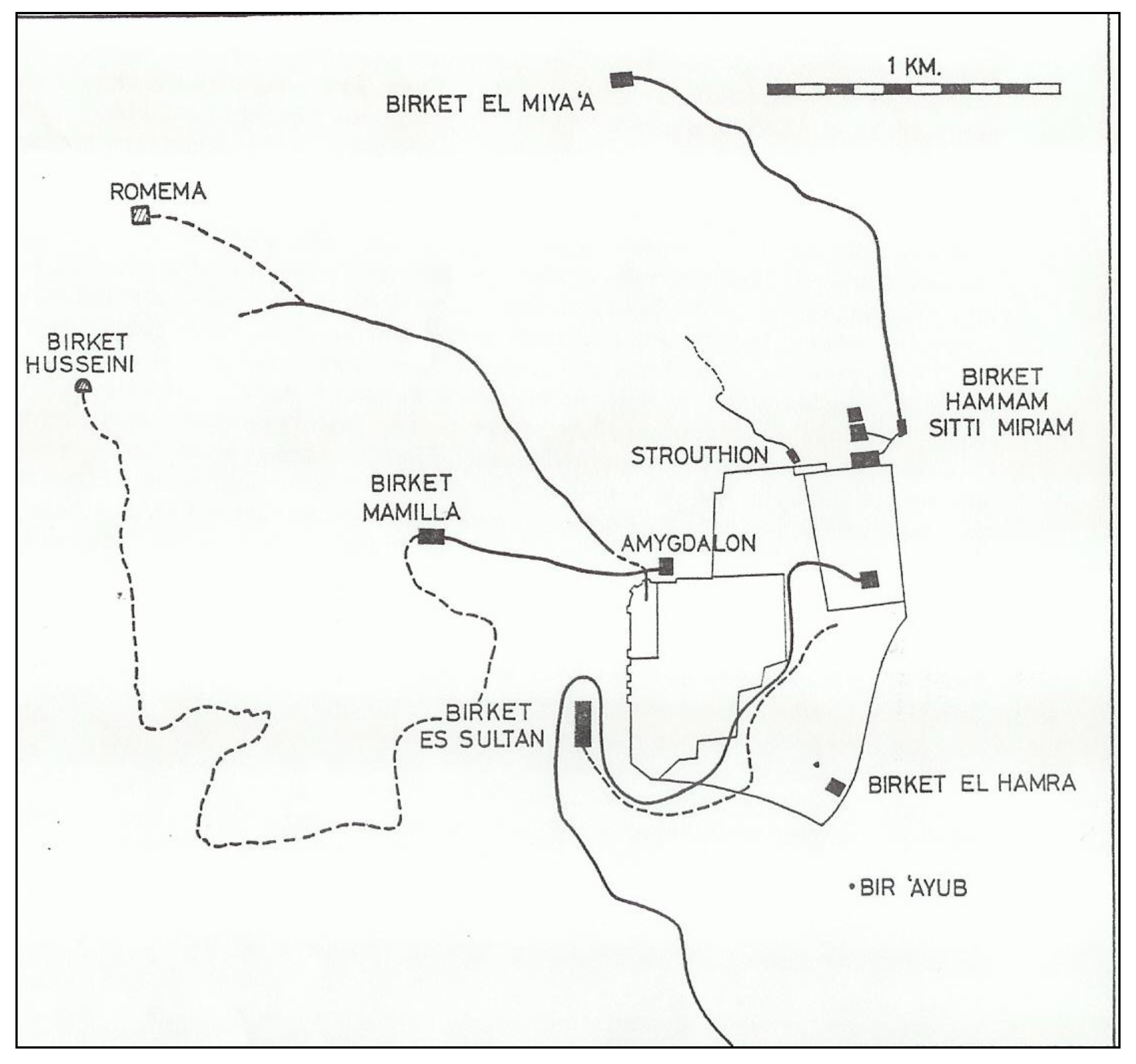
In terms of the landscape setting of water harvesting pools in Jerusalem, only a few pools are located now inside the current city wall, e.g., Birket Hammam Setti Miriam, Birket Israel, and Birket Hammam Al Batrak. These pools were included later within the city wall after their construction for various uses. A few harvesting pools are located now far from the present city wall, specifically northwest of the city, such as Birket Husseini and Birket Mamilla (
Figure 5). Topographically, the landscape settings of the harvesting pools inside and outside of the city wall are mostly related to the slope of the landscape that brought the water runoff into the pools. According to Wilkinson [
4], a few pools were connected together by a channel. For example, a channel segment was discovered connecting Birket Mamilla with Birkect Hammam Al Batrak; this connection transported water from the high pool (Birkect Mamilla) into the lower one (Birket Hammam Al Batrak).
Figure 5.
Water harvesting pools inside and outside the city wall of Jerusalem. From [
5].
Figure 5.
Water harvesting pools inside and outside the city wall of Jerusalem. From [
5].
The underground water system and the harvesting pools system were the main ancient water systems in Jerusalem city until the construction of aqueducts during the early Roman period. Actually, the use of the underground water system and associated parts was not completely for domestic purposes, but some of the system parts (the springs and channels) were used in agricultural activities in Wadi Sitti Miriam. Some of the harvesting pools were working alone, while others were incorporated within the aqueducts’ water system.
4. Jerusalem Ancient Aqueduct Water System in the Roman Period
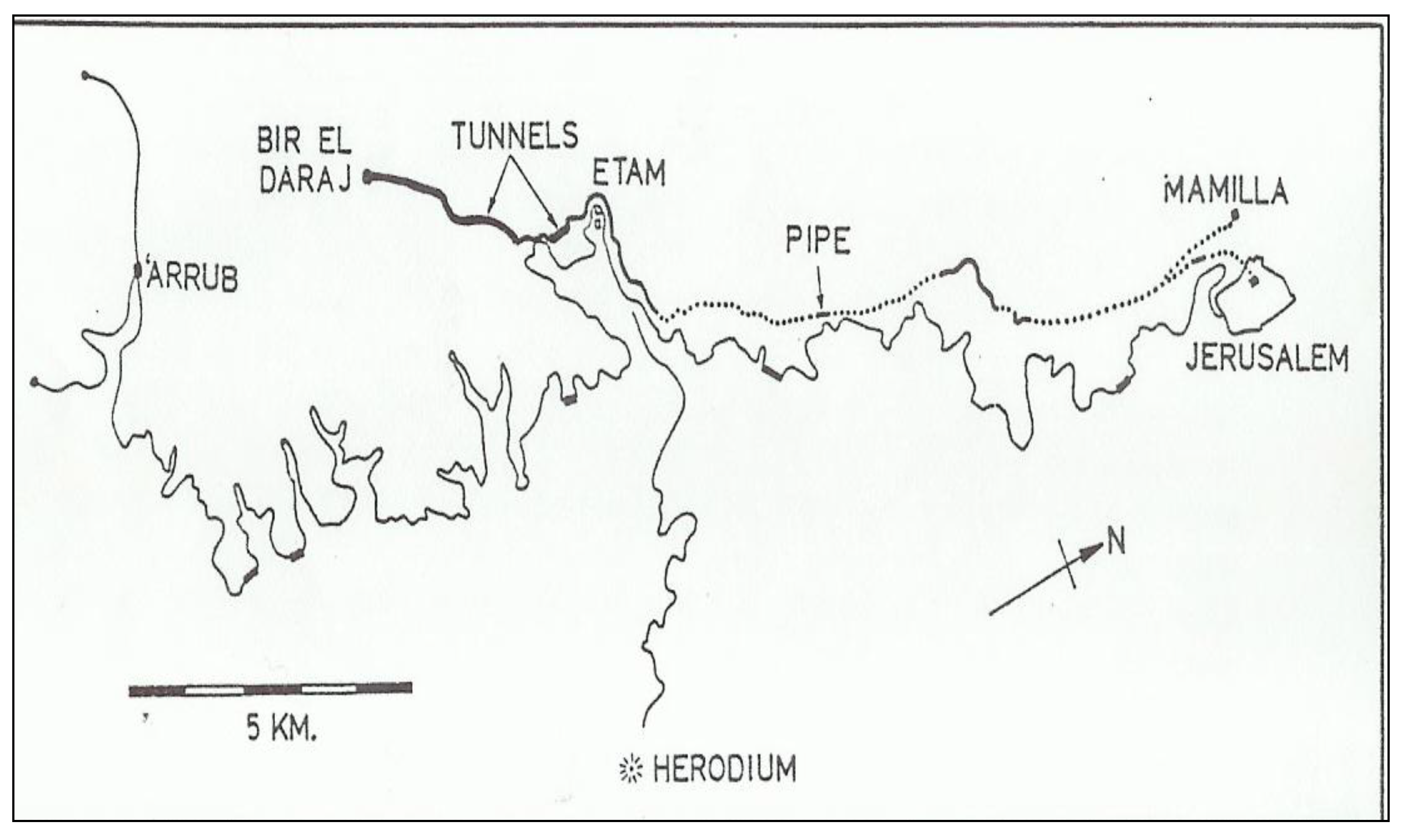
The construction of the aqueduct water system in the Roman period was a consequence of the impact of urban development in Jerusalem. Upon occupation, the Romans relocated Jerusalem from Tell Abu ed-Duhur (Middle Bronze and Iron Ages). The Roman Jerusalem was re-sited at a new location relatively in the same location as the current Old City of Jerusalem. This change in city location was associated with the establishment of the water aqueduct systems to transport freshwater from the springs located south of Jerusalem.
Due to these changes, the ancient water system of Jerusalem during the Roman period included aqueducts that were erected over long distances, in addition to the springs, pools, and tunnels. The various elements of this water system worked together under one unified water system to provide Jerusalem with domestic water. One main reason behind adopting this water transport system was that the springs are located should of Jerusalem, exactly between the village of Artas and the Hebron region. Within this region, there were many freshwater springs with a shallow water table characterized by strong water discharges. In addition to that, these springs have approximately the same elevation as ancient Jerusalem city, thus allowing the conveyance of the water by natural gravity through aqueducts from the Hebron-Artas region into Jerusalem city during the different historical periods (
Figure 5 and
Figure 6).
Figure 6.
Al-Arroub and lower aqueducts between Hebron-Artas and Jerusalem city. From [
7].
Figure 6.
Al-Arroub and lower aqueducts between Hebron-Artas and Jerusalem city. From [
7].
4.1. Freshwater Springs and Aqueducts in Wadi Al-Arroub Region
In the Wadi Al-Arrub region, there are many springs, such as the Kuweiziba spring, Qanat Al-Arayis spring, Ed Dilba spring, and Al-Arrub spring, which are all connected by a channel to bring the water into Al-Arrub pool. The Al-Arrub pool is located at about 8 km south of Artas village with a surface area of about 4,080 m
2 and a storage capacity of around 200,000 m
3. All of the stored water in Al-Arrub pool was usually transferred through the Al-Arrub aqueduct. This aqueduct runs from Al-the Arrub pool until the middle pool in the Artas valley. The total length of Al-Arrub aqueduct is about 44.2 km; the depth of aqueduct ranges between 0.70 and 0.90 m and it has a width of 0.50 m [
7,
8]. The long distance of the Al-Arrub aqueduct follows the topographical contours of landscape in the region in order to transport the water through the aqueduct by gravity into the middle pool in the Artas valley. Along the distance of the Al-Arrub aqueduct, there are many water installations; the most important of them are the three tunnels used to cross the valleys or to avoid the sudden rise of the topography located along the aqueduct’s path.
A review of Arabic historical records revealed that the Al-Arrub aqueduct has been restored many times and the most important one was done by Qansawa Al Yahyawi in the year 1483 A.D. This information indicates that the Al-Arrub aqueduct may not have been in use before this restoration process, but surely it was reused during the late Mamluk period (1483–1517 A.D.) and the Ottoman (1517–1917 A.D.) era. In the early British Mandate (after 1918), use of the Al-Arrub aqueduct was stopped and a new iron pipe was installed from the Wadi Al-Arrub springs into the new urban areas located to the south of historical Jerusalem. During the Roman period, the Wadi Al-Biyar aqueduct was constructed south of Artas (
Figure 6), where Wadi Al-Biyar spring was the main spring which fed this aqueduct. The aqueduct consisted of four parts; the first part is a tunnel which is 3 km long with an internal height of about 1.5 m, and an internal width of about 0.80 m. Within this tunnel there are about 80 vertical shafts of variable heights (5–23 m) from the ground surface down into the tunnel.
The second part of the Wadi Al-Biyar aqueduct is an open channel 700 m long. The third element of the Al-Biyar aqueduct is a tunnel 700 m long with 10 vertical shafts. Finally, the fourth part is an open channel (1 km long) that forms the final link between the Al-Biyer aqueduct and the upper pool in Artas valley. The Al-Biyar aqueduct was functional from the date of its construction in the Roman Period until the British Mandate. The reason behind the aqueduct’s long-term use might be the design and construction as a closed tunnel in order to avoid aqueduct blockage through sedimentation and waste disposal.
As shown in
Figure 5 and
Figure 6, the upper Artas valley consists of three pools—the upper, middle and lower—in addition to several springs such as the Salih, Faruja, Burak, and Attan springs, forming the heart of the Jerusalem aqueduct system.
Table 1 lists the technical dimensions of the Artas valley pool system. Probably, the Romans constructed this pool system for water balancing rather than water storage. They transported water from the pools in the south by the Al-Arrub and Wadi Al-Biyer aqueducts which were being used as booster pools for domestic water further on to Jerusalem through two other aqueducts; the upper and lower aqueducts. Salih spring, located west of the upper pool, has the function to feed water to the upper pool through a 120 m long tunnel. The upper and middle pools are connected together by an underground water tunnel. Until the pre-Mamluk Period (1250–1517 AD), both pools fed the lower aqueduct, while the upper pool supplied the upper aqueduct with water.
Table 1.
Technical aspects of the Artas valley pool system.
Table 1.
Technical aspects of the Artas valley pool system.
| Name | Length (m) | Width (m) | Depth (m) | Storage Capacity (m3) |
|---|
| Upper pool | 119 | 72 | 9–11 | 85,000 |
| Middle pool | 135 | 50–70 | 10–12 | 90,000 |
| Lower pool | 179 | 46–61 | 8–16 | 113,000 |
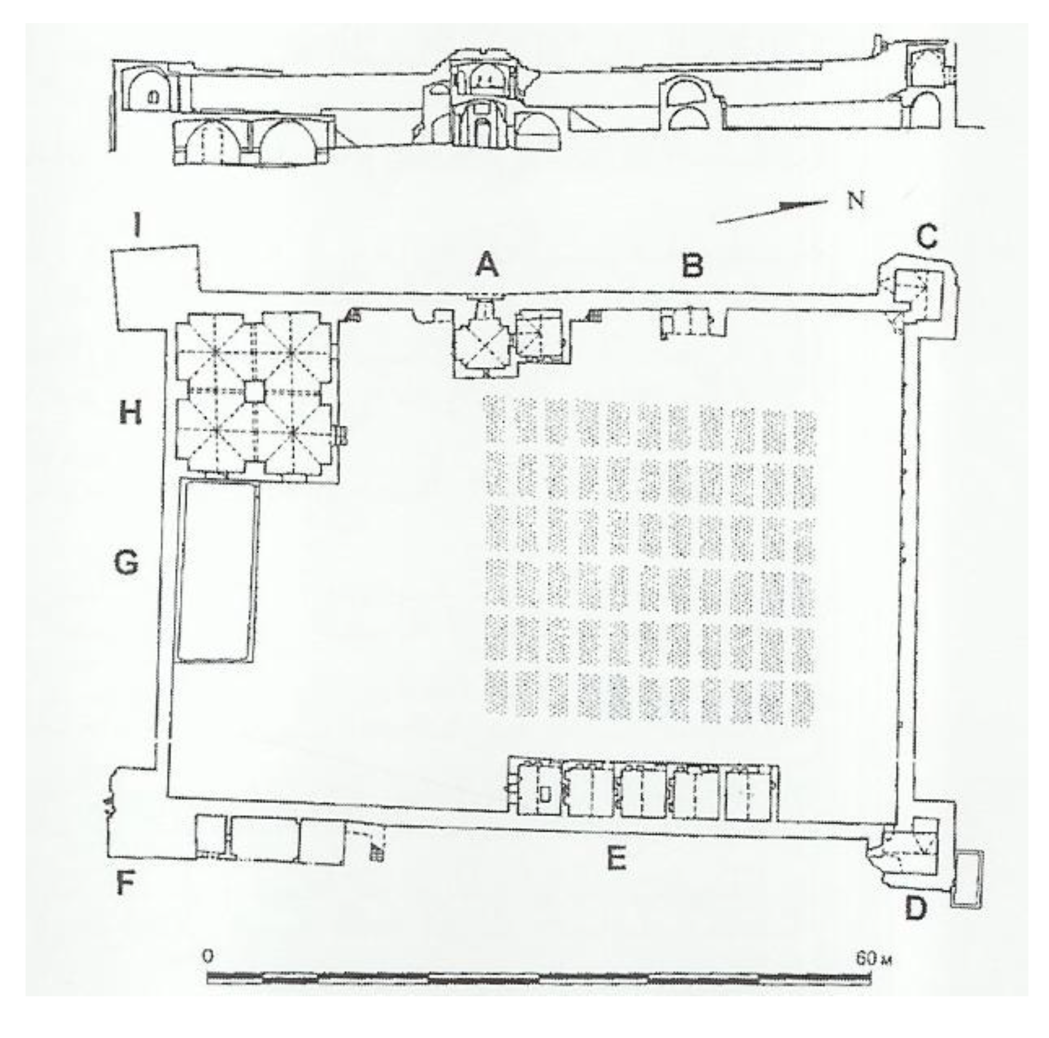
According to Hawari [
9], under the control of Qaytaby (1468–1495), the lower pool was constructed to increase the water storage capacity in the upper Artas valley, thus increasing the total amount of domestic water transported by the lower aqueduct to Jerusalem. Archaeologically, the surface archaeological evidence in the upper Artas valley reveals two archaeological sites located near the pools, Khirbet ‘Alya, and Khirbet Al-Khaukh (
Figure 7). These have probably a satellite function in the region to protect the pools and aqueducts during the Roman period and onward. The satellite function hypothesis is evident more during the Ottoman period.
Figure 7.
Al-Burak castle in the upper Artas valley. From [
9].
Figure 7.
Al-Burak castle in the upper Artas valley. From [
9].
During the reign of Othman II (1618–1622 A.D.), the Al-Burak castle (Arabic Qala`t Al-Burak) was built to promote the Ottoman rule as centralized control over the Artas valley in order to protect the pools and the lower aqueduct. Located to the northwest of the upper pool, the Al-Burak castle exists until present time, having a rectangular structure with a length of 70 m and about 45 m in width [
9]. During the late Ottoman period, local villagers in the area replaced the Ottoman rule and took over protection of the Artas pools, whereas the castle sustained its function until the early British Mandate.
4.2. Upper and Lower Aqueducts as Ancient Water Supply Systems for Jerusalem
As mentioned above, all the water storage in the pools of the upper Artas valley was conveyed further to Jerusalem by two aqueducts, the upper and lower aqueducts. The upper aqueduct, erected with a wheel stone of 13 km in length, was connected with the upper pool, and reached into the Citadel of Jerusalem city (see
Figure 6). The height of the upper aqueduct ranged between 0.90 and 1 m with an internal diameter 0.33 m central hole. The wheel stones when fitted together formed a stone pipe over a total length of about 3 km; however, Mazar [
8] reported in 1974 that only 300 m were preserved in the ground (
Figure 8). In the Byzantine era, the upper aqueduct was not functional, leading to the assumption that the lower aqueduct was the only main water supply system for Jerusalem until the British Mandate [
10].
Chronologically, the lower aqueduct was constructed in the early Roman period, and it was supplied with water from the upper and middle pool, and also from the Ain Atan spring, which is located to the southeast of the middle pool. As the lower pool was added in the Mamluk Period, the lower aqueduct was reconnected with the lower pool. The archaeological evidence shows that some parts of the lower aqueduct were dug in the rock, or built with stones to create a channel, while other aqueduct sections were covered by slab stones either to prevent water evaporation or to preserve the water quality against soil intrusion and waste materials.
Figure 8.
The upper aqueduct with wheel stones. From [
10].
Figure 8.
The upper aqueduct with wheel stones. From [
10].
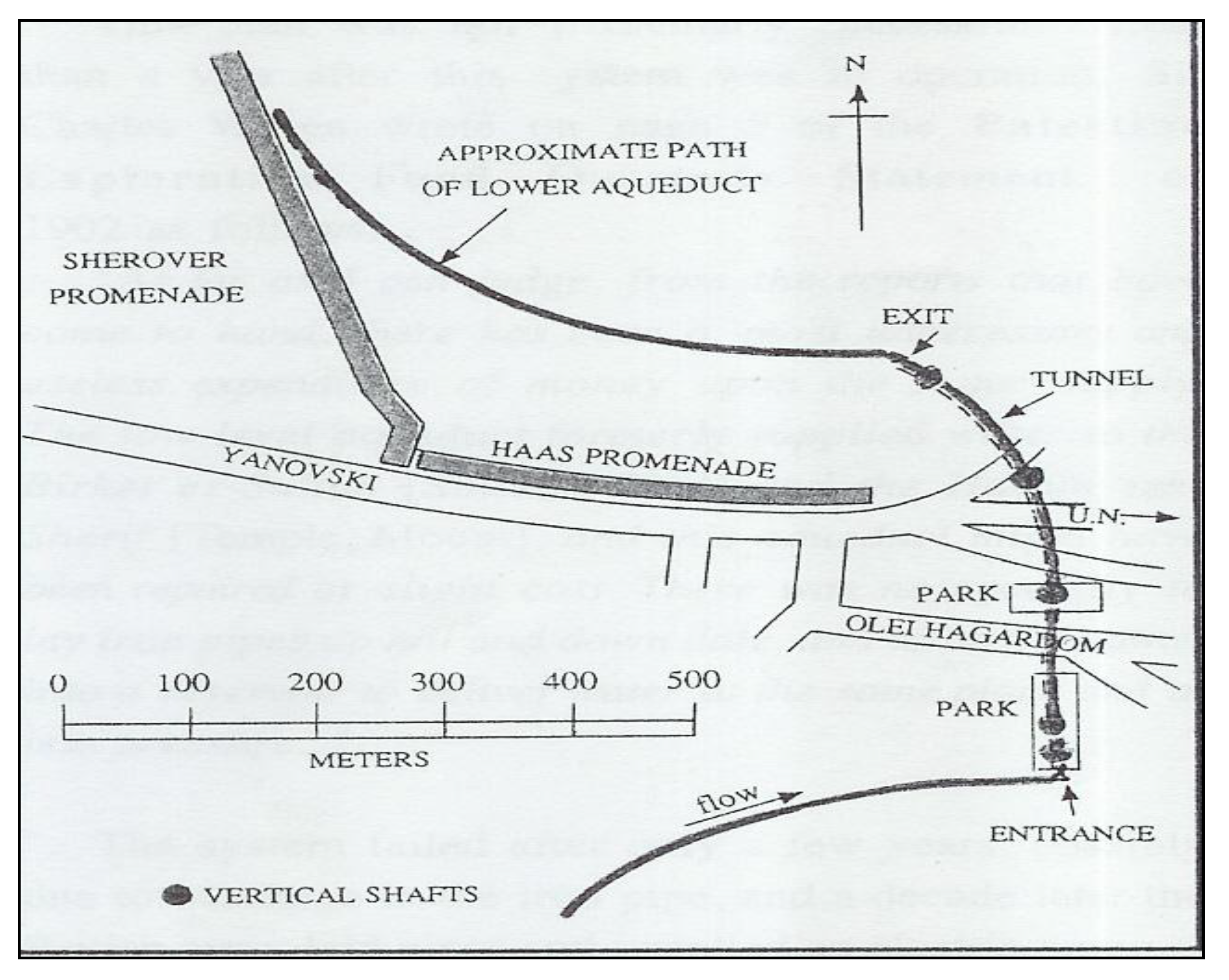
Starting from Artas Valley until the south wall of Jerusalem city, the total length of the lower aqueduct is about 21 km with a variable width (0.40–0.50 m) and a height of about 0.60 m. Abells and Arbit [
7] presented an approximate path of the lower aqueduct showing the tunnels with vertical shafts (
Figure 9). The lower aqueduct entails also two tunnels; the first is located north of Bethlehem (length: 360 m), the second is located in the Jabal Al-Mukabbir region south of Jerusalem. The latter has a length of about 423 m within which three vertical shafts are built. Actually, the aim of the tunnel construction at that time was probably to avoid the topography level increment along the course of the lower aqueduct.
Figure 9.
Lower aqueduct showing tunnels with vertical shafts. From [
7].
Figure 9.
Lower aqueduct showing tunnels with vertical shafts. From [
7].
During the various ancient eras, the lower aqueduct supplied many pools in Jerusalem with water; some of the pools were also located outside the city wall, while others were inside the wall of the city (
Figure 10). Located outside, northwest of the city wall, Birket Es Sultan was the most important pool (length: 595 m; width: 245–275 m, and depth: 35–42 m). According to Wilkinson [
4], there were seven pools located within the wall of the city, the most important of which was located in Al Haram Ash-Sharif.
Figure 10.
Location of pools inside and outside Jerusalem wall. From [
5].
Figure 10.
Location of pools inside and outside Jerusalem wall. From [
5].
Actually, the lower aqueduct was the main water supply system of Jerusalem during the early Roman period until the mandated period (1918–1948). Thus, there has been a lot of a restoration made in the past by the administrative management of water in Jerusalem in order to maintain the water running in the lower aqueduct. Historically, the documents show that Thaher Bibarus (1267 A.D.), and King Mohammad Ibn Qalawun (1327 A.D.) in the Mamluk Period [
11] did such restoration work.
5. Ottoman Era Aqueduct Systems
In the early Ottoman epoch, Sulaiman Al Qanuni (1541–1568 A.D) undertook many restoration activities, including cleaning the lower aqueduct. The causes of occasional malfunction in the lower aqueduct were due to the accumulation of waste materials in the aqueduct, which eventually caused complete aqueduct blockage. In addition to that, in the late Ottoman epoch (1786 A.D.), water resources managers made civil works changes on the aqueduct system. They replaced the open channel sections in the lower aqueduct by pottery pipes. The pottery water pipes installation during the Ottoman era represented a state-of-art technology aimed at efficient use of available scarce water resources. Compared to open aqueduct sections, closed piping systems reduced water evaporation during the hot summer, minimized pollution caused by animals accessing the open water course for drinking, and prevented farmers from irrigating their agricultural fields located along the open aqueduct sections [
12].
However, lack of practical knowledge in operation and maintenance, and the clogging of pottery pipes with time formed a real operational problem and a technological challenge for municipal water supply engineers. They realized that sediment transport from the water pools and accumulation of sediment and formation of biofilm structures enhanced by the rough internal surface of pottery pipes minimized the flow rate. To solve the pottery pipe clogging of the lower aqueduct, the water supply engineer’s of the late Ottoman epoch (1898 A.D.) installed an iron pipe (
Figure 11) between Bethlehem and Jerusalem. The installation of the iron pipe during the late Ottoman period in the lower aqueduct was considered as the first application of western know-how in water supply technologies in Palestine.
Figure 11.
Installed iron water pipe during the Ottoman epoch. From [
10].
Figure 11.
Installed iron water pipe during the Ottoman epoch. From [
10].
6. British Mandate Era
During the British Mandate period, the government applied modern water technology through digging vertical wells in the Jerusalem region, and installed water mains to supply the new urban area located to the south of the historical city of Jerusalem. The lower aqueduct was still functional during the Mandate period to supply a few parts of the old city of Jerusalem. However, gravitational conveyance of drinking water from the Artas pools into old Jerusalem was replaced by installing booster stations to transport drinking water through the pipe of the lower aqueduct. The lower aqueduct was in operation until the 1948 war and after that it was divided and managed by both the Jordanian and Israeli authorities.
7. Major Threats and Future Outlook
There are various threats to the sustainability of ancient water systems in Jerusalem such as lack of an up-to-date statutory outline plan, absence of a comprehensive urban master plan, combined with the socio-economic problems. Although the level of threat to the ancient water supply systems has generally decreased recently, ancient water facilities are still at risk from major unsustainable development because they lack solid protection in the past and current planning systems. National planning policy guidance refers to nature conservation and amenity value of ancient water systems that may lie outside non-designated sites, but offers no further guidance on how to assess projects that affect ancient water facilities. Local development plans may, however, contain policies referring to the conservation and value of ancient water and sanitation infrastructures. Hence, sustainability is particularly relevant to Jerusalem, where national and international responsibilities must be coordinated to protect the ancient water and sanitation systems and to preserve the heritage values that are carved into its landscape, while maintaining respect for the different needs and beliefs of its various population communities.
8. Conclusions
The archaeologists and water engineers from the Bronze era until the British mandate were able to achieve the principles of integrated water resources management in the context of public health hygiene and efficient use of available water resources in Jerusalem. The ancient aqueduct systems (water pools and channels) were well engineered designed, constructed and operated in a way similar to current urban water systems developed in the 19th century A.D. However, all ancient water supply systems in Jerusalem are a topic that is hard to cover in one paper of limited space. Review and critical analysis of available literature revealed that Jerusalem’s ancient water systems are very complicated as they served most likely multi-functional uses in different historical periods. Hence, further studies should concentrate not only on the ancient water supply systems, but also should explore sanitary and stormwater management in order to understand the so-economic structures of ancient societies that lived in the Jerusalem area. Also, the ancient water systems of Jerusalem should be classified as a world heritage resource. Their protection and technical and financial support should be secured by local, regional and international communities. As a tool for sustainable development, effective environmental assessment should be applied to protect these ancient water facilities of national heritage value against major development proposals and urban infrastructure projects in Jerusalem.


