Modeling and Simulation of the Future Impacts of Urban Land Use Change on the Natural Environment by SLEUTH and Cluster Analysis

1
Department of Urban Planning and Landscape, National Quemoy University, Kinmen County 892, Taiwan
2
Department of Urban Planning, National Cheng-Kung University, Tainan City 701, Taiwan
*
Author to whom correspondence should be addressed.
Sustainability 2018, 10(1), 72; https://doi.org/10.3390/su10010072
Submission received: 15 November 2017
/
Revised: 19 December 2017
/
Accepted: 28 December 2017
/
Published: 29 December 2017
(This article belongs to the Section Sustainable Urban and Rural Development)
Abstract
:Changing land use and urban expansion are key drivers of global environmental change, which are inevitable consequences of economic and social development for many cities. Most land use changes have a negative impact on the natural environment, especially due to their effects on surface temperature, runoff and habitat diversity. Due to the limitation of local government funding and expenditure, it is a challenge for developing countries to create strategies for urban sustainability. This study provided a systematic assessment method for simulating and analyzing the future impacts and spatial patterns of urban growth via cellular automata and cluster analysis. We used Tainan as a study area and compared the impact of future urban spatial development during two periods: 1993–2008 and 2008–2030. The results indicate that the impact of this development on the natural environment can be divided into six clusters. With an increased distance from the city center, there were increased changes in surface temperature and a decreased amount of runoff. These results indicate the occurrence of urban expansion, with habitat diversity being greater in areas governed by policies or ordinances.
1. Introduction
According to the 2017 Revision of World Population Prospects, the global population is expected to reach 8.6 billion in 2030, while the population of Taiwan is expected to reach 24,150,708 in 2030 [1]. The total population of Taiwan was 19,258,053 in 1985 and 23,293,524 in 2014. The percentage of the population living in urban areas was 73.04% in 1985 and 79.74% in 2014. The increasing population will increase various demands for production and life, which are considered as important driving forces that have caused changes in urban land use [2,3,4]. Changing land use and urban expansion are the key drivers of global environmental change, which are inevitable consequences of economic and social development for many cities. The size of urban areas and urban populations have been increasing rapidly and continuously across the whole world due to urbanization.
The spatial patterns of land use change result from interactions between political, economic, social, environmental, cultural and other factors [5], which often cause direct and serious negative impacts on the natural environment [6,7]. These impacts are manifested primarily as changes in the material and energy cycles of the ecosystem, which are caused by urban land use. These changes affect the development, equilibrium and stability of natural ecosystems. When the accumulation of negative impacts on the natural environment reaches a saturation point or the ecosystem cannot withstand these impacts, the damage may be irreversible [8]. Due to the limitation of local government funding and expenditure, it is particularly challenging for developing cities to create sustainable urbanization strategies.
Therefore, understanding and fully controlling the impact of land use changes on the natural environment have become critically important research topics in land use planning for the sustainable development of urban environments. The range of the impact of urban land use on the environment is extensive. Previous studies have demonstrated that land use changes can affect habitat suitability and diversity [9,10], water resources [2], surface runoff [11,12,13,14], surface temperatures [15,16,17] and nitrate content [18]. While many studies have focused solely on particular impacts [19,20,21], there is a lack of information on the overall impact of urban land use change on the natural environment at the urban neighborhood scale. This information is important for obtaining a better understanding of the sustainability of urban development processes and to help to create strategies to mitigate consequences.
To address these matters with a view toward environmental protection, we propose a systematic assessment method for simulating and analyzing the future impacts and spatial patterns of an urban growth model. Among the existing modeling tools, Cellular Automata (CA) is regarded as an effective tool for simulating dynamic changes in urban environments [22,23,24,25,26]. Through interactions of land use conditions, the characteristics of adjacent cells and land development rules, CA can simulate and predict the results of policies for managing urban development [22,26,27,28,29,30].
Additionally, in order to validate the applicability of the proposed method, three criteria were used to select the empirical research area: (a) urban development and its impact on the environment are generally significant; (b) there are diverse land use patterns; and (c) urban development strategies are related to improved sustainability. Based on the above concerns, Tainan, the fourth largest city, with 3.3% of the total population in Taiwan, was selected as the study area. The population of Tainan increased from 639,888 to 779,065 from 1985 to 2014. The average temperature in July was 28.4 °C in 1985 and 30.4 °C in 2014, while the average annual temperature was 23.7 °C in 1985 and 24.6 °C in 2014. The average annual rainfall was 1391.6 mm in 1985, 1268.1 mm in 2014 and 2720.9 mm in 2016. Due to climate change and urban development, the average temperatures are still rising in Tainan. On the other hand, the annual rainfall is unstable, with a maximum of 3148.5 mm in 2005 and minimum of 898.5 mm in 2003, with a standard deviation of 528.7 mm.
In order to compare the allocation differences of the overall impact across each spatial unit and to analyze its relationship to urban development, certain basic principles have been developed. This includes a significant standard measurement to assess the impact and the practical applicability of urban planning, which reflects the developmental characteristics of the area for empirical research. A total of 233 urban neighborhoods, which make up the fourth level administrative subdivisions of Taiwan, were used as the units of analysis. The basic unit of Taiwanese administrative subdivision in districts is useful for connecting the strategies of urban growth, as all predictions and assessments of natural environmental impact indicators are combined at this level.
Specifically, due to the limitations of local government funding and expenditure, development strategies for group neighborhoods need to be created by developing cities. However, it is difficult for policy-makers and planners to comprehensively and effectively master the spatial characteristics of all environmental impacts at a relevant level. Therefore, multivariate statistics were used to reduce the environmental impact indicators to explore the distribution characteristics and a cluster analysis was conducted for urban development strategies to generate recommendations concerning future development.
2. Environmental Impacts of Urban Growth
Urban development typically results in an increase in impermeable surface areas, such as buildings and roads, and a decrease in agricultural land areas and permeable urban habitats. These changes have a direct impact on different dimensions. In order to choose key indicators to reflect the causes and impact of urban land use change, we performed a literature survey of suitable indicators based on the reliability, usability, availability and usefulness criteria. Finally, based on data availability and practicality at the neighborhood level, three final indicators were selected: surface temperature [15,16,17,31], surface runoff [2,11,12,14,31] and habitat diversity [9,10,13,31,32].
2.1. Surface Temperature
Land use changes affect urban climates by increasing the impermeable surface area, which subsequently will absorb more solar energy and raise surface temperatures [33]. When the air temperature is higher in urban areas than in the suburbs due to concentrated development in the former, the urban ecology is negatively affected [15,16,17,19,34]. Surface temperature is one of the most important indicators in assessing the role of land use changes in environmental degradation.
2.2. Surface Runoff
During urban development, an increase in impermeable areas, such as buildings and roads, increases the amount of surface runoff. Several recent studies [11,14,16,21] have indicated that urbanization replaces vegetation with an impermeable layer of buildings and reduces water infiltration, thereby increasing runoff and the frequency and severity of flooding in cities.
2.3. Habitat Diversity
Urban habitats are important spaces for urban wildlife. When more types of urban habitats are available, there is greater species diversity [9,10,16,20,32]. Land use changes generated by urban development often reduce the variety of habitat types, thereby reducing both the habitat area and diversity.
3. Materials and Methods
3.1. Study Area
The study area, Tainan, is located on the southern coastal plain of Taiwan (120°11′6.3″ E, 22°59′31.9″ N) (Figure 1). It had a population of 764,658 and covered an area of 184.16 km2 in 2008. The density of population is 4152 person/km2 in the city and 6624 person/km2 in the city without agriculture land. It is divided into six administrative districts, including Annan, Anping, East, North, South and West Central, with a total of 233 neighborhoods.
According to the Land Use Investigation of Taiwan, 2007, there are 92 types of land use in Taiwan and 79 types of land use in Tainan, with a Shannon’s diversity index of 3.033. Thus, Tainan is characterized by a highly diverse, complex set of land uses. In Tainan, agricultural land covers the largest area (37.32%), followed by urban land (37.29%), other land uses (14.88%), water conservation areas (8.63%), forest land (1.64%) and rock salt (0.24%).
3.2. Framework for Simulating Land Use Changes and Environmental Impact Patterns
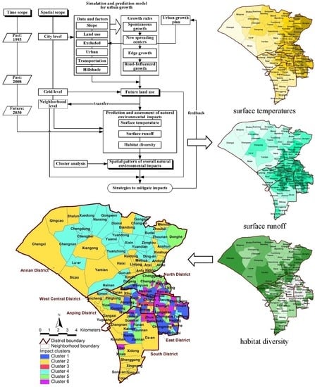
The method proposed here was designed to dynamically simulate the impact of future urban development on the natural environment (Figure 2). It consists of multiple spatial levels, which are specifically the city level, grid level and neighborhood levels, and multiple time levels, including the past and several years in the future. This model is useful for simulating future land use at the grid level and comparing different spatial and temporal impact patterns between neighborhood levels. It is useful for dynamic spatial analyses, generating strategies for mitigating overall impact and providing feedback for plans for urban growth.
3.2.1. A Simulation and Prediction Model for Urban Growth
The purpose of the study is to simulate and predict the land use resulting from the urban growth plan and to predict future spatial development patterns of land use and its distribution, location, scale and so on. Therefore, the model must possess spatial, dynamic and normative features. The SLEUTH model is named by the first alphabet of the layers of geographic information, slope, land use, excluded, urban, transportation and hillshade. This model was designed by both the United States Geological Survey and the University of California at Santa Barbara. It uses cities as analysis objects to simulate dynamic processes of urban land development. It is a class of models in which the land surface is divided into cells in a regular grid to simulate urban development and its impact on the surrounding land use. Due to the model being based on the land characteristics of the developed land in the city, SLEUTH can produce reliable long-term information related to urban development. Together with the required data structure, the results of the model can provide information for use in sub-models [35]. Therefore, SLEUTH models are used for research and application in urban simulation studies in order to obtain useful results [26,30,36,37,38,39]. The SLEUTH model addresses changes in the behavior of land use based on the concept that landscape changes along with the spreading of urban development, with land transformation rules being defined by the definition of urban growth dynamism in the sequence of spontaneous growth, new spreading center growth, edge growth and road-influenced growth [40]. These four growth types are applied sequentially during each growth cycle and are controlled by five growth coefficients: dispersion, breed, spread, road gravity and slope. Each coefficient has a value that in the range of 0–100. The calibration procedure begins with the geographic map of the earliest years with the combination of five parameters having values of 0–100 in permutation and combination methods for model calculations from {1,1,1,1,1} to {100,100,100,100,100}.
Spontaneous growth means the generation of new urban development land grids when development land grids exist in the neighboring areas of a randomly selected grid and the control parameters of the grids meet the requirement of change. The growth type of diffusive growth or spread of a new growth center refers to a group of the urban land grids fulfilling control parameter criteria and becoming the urban center of expansion, with these neighboring grids transforming into the urban land grids. Edge growth simulates the outward growth from the edge of new and existing urban centers, which is controlled by the spread coefficient. This coefficient influences the probability that a non-urban cell with at least three urban neighbors will also become urban land. Road-influenced growth means that when there are roads next to randomly-selected grids, the grids within a certain distance from the road will transform themselves into the urban land grid.
The mentioned rules of land use change are influenced by several coefficients, including the diffusion coefficient determining new growth centers and the expansion of roads; the breed coefficient deciding whether an independent urban land grid group can become a growth center; the spread coefficient controlling the organization growth; the slope resistance influencing the possible growth location; and the road gravity coefficient that attracts new growth spots.
SLEUTH requires input from historic urban maps from four time periods, two historic land use maps, four historic transportation maps, a single map containing the slope gradient, a hillshade layer for use as a background with the graphic version of the model and a map of areas excluded from urbanization (the probability of exclusion based on the urban growth plan). When creating a SLEUTH simulation, the optimal parameter selection is based on the Lee–Sallee shape index [41] for the measurement of spatial fit between the modeled growth and the known urban extent for control years. A high Lee–Sallee value shows a high simulation accuracy [29,39,42,43,44,45].
3.2.2. Prediction and Assessment of Natural Environmental Impact
Surface Temperature
In this study, surface temperatures were estimated using a formula based on surface temperature research in the Tainan area [46]:
where Y is the surface temperature (°C), Lb is the built-up land ratio (%, total area of urban land/total area of each neighborhood), Dc is the shortest Euclid distance from the centroid of each neighborhood to the coast (km), Ds is the Euclid distance from the centroid of each neighborhood to the Tainan train station (km) and Wd is the density of water (%, total area of water/total area of each neighborhood).
Surface Runoff
In this study, the relative area of each type of land use was used to calculate a runoff coefficient for further exploring spatial variations in the impact of land use changes. The equation for estimating runoff volume (Q) based on precipitation and the land use characteristics of a neighborhood is as follows:
where Q is the volume of overland flow draining off the land (m3/s), C is the runoff coefficient and is equal to 0.34 + 0.46 Imp, where Imp is the impervious ratio (%, area of impervious land/total area of each type of land), I is the rainfall rate (mm/h) and A is the catchment area (ha).
Q = 0.278CIA
Habitat Diversity
The habitat diversity index is calculated based on the relative area of each habitat type in a neighborhood. The structural diversity is essentially a Shannon–Weaver index, although it is applied to urban habitats to include green space, wetlands, grassland, forest, farms, rivers and scrubland as follows:
where Pk is the probability of habitat type k, n is the number of habitat types and Ak is the area of habitat type k (ha).
3.2.3. Cluster Analysis of Spatial Patterns of Overall Natural Environmental Impact
Cluster analysis was employed to discuss the spatial distribution of the overall impact on the natural environment in 233 neighborhoods. Cluster analysis is the general logic, formulated as a procedure, by which we objectively group the entities together on the basis of their similarities and differences [47,48,49,50].
Previous empirical studies [30,51] have suggested that the K-means is best for recovering the true groupings of data if a non-randomized starting point is assigned. A K-means clustering method does not require the computation of all possible distances of analyst neighborhoods. The algorithm repeatedly reassigns neighborhoods to clusters, so the same neighborhoods can move from cluster to cluster during the analysis.
We selected K-means as the clustering algorithm, with the Euclidean distance being the distance measure used to generate clusters, where K is the number of clusters we want. The process of K-means begins with specifying the expected number of clusters and the expected centroid of each cluster. The K-means is a robust method for identifying groupings within a data set for minimizing within-group variability and maximizing between-group variability [30,49,51,52].
However, automatically determining the number of clusters has been one of the most difficult problems in data clustering. Most methods for automatically determining the number of clusters have assigned it as a problem of model selection. Usually, clustering algorithms are run with different values of K, before the best value of K is chosen based on a predefined criterion [50]. In this study, we selected the number of clusters with silhouette analysis. In this study, we used the Wards method to determine the possible number of clusters, before using the K-mean method to assign the number of clusters. According to the results of different numbers of clusters, we combined these results with the spatial map to discover the spatial pattern by geographic information system (GIS). Finally, we used the experimental rule and overall spatial pattern to determine the final clusters.
3.3. Data for Simulation, Prediction and Assessment
Data for simulation, prediction and assessment were primarily collected from the Land Use Investigation of Taiwan (1993, 2008); the 20-m DEM (Digltal Elevation Model) of the Council of Agriculture; the Taiwan Electronic Map, 2014; the Topographic Map, 1985; and the simulation results for urban growth in 2030 (Table 1).
An example of the processing of the data is shown in Figure 3. The land use at the city level (a) is resampled at the grid level at a resolution of 20 m (b). Following this, the neighborhood boundaries are plotted (c) and the grid level land use within neighborhoods of each year is obtained (d). Finally, we obtained the impacts on the natural environment (e) and (f) based on the future land uses within neighborhoods.
4. Results and Discussion
4.1. Simulation and Prediction Land Use Change of Urban Growth
Calibration is one of the most important elements of successful model application. The aim of calibration is to derive a set of coefficients for the effective modeling of urban growth during a historic time [29]. The results of the model prediction must be assessed for representativeness using statistics from related feature indexes. For the feature indexes that were used, the comparison value was 0.98, which is an indicator of the similarity between the modeled final urban extent to the real final urban extent. The value of r2 population was 0.82, which represents the least square regression score of modeled urbanization compared with actual urbanization for control years. To assess the spatial fit performance, we used a Lee–Sallee shape index expressed by the ratio of the intersection as well as the union of the simulated and actual urban areas in SLEUTH. The maximum Lee–Sallee value is 1. We obtained a Lee–Sallee index of 0.67. Comparison of SLEUTH results from previous studies provided a context for our results. Sakieh et al. obtained a Lee–Sallee value of 0.59 for Karaj in Iran [45]. Shi et al. obtained a Lee–Sallee value of 0.61 for Shanghai [43]. Osman et al. obtained a Lee–Sallee value of 0.56 for the greater Cairo metropolitan region [44]. Silva and Clarke obtained Lee–Sallee values of 0.35 for Lisbon and 0.58 for Porto [42]. Thus, this indicates that the calibration process for this study was satisfactory. Therefore, it can be assumed that based on the simulation results of historical land development in Tainan, the proposed model has good explanation ability. On this foundation, the model was used to predict the city’s future land use changes.
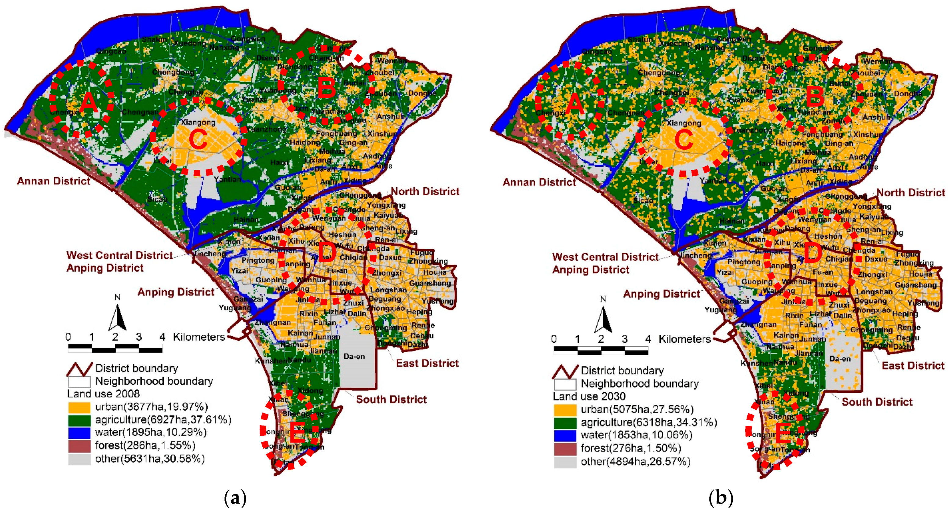
The simulation of future urban development predicted that agricultural land will remain the predominant land use until 2030 (Figure 4) and that the total developed urban area will be larger than the total area of other land uses, implying that the area of land available for development will be smaller than the area of developed land in the city. The area of urban development was predicted to increase from 3677 hectares in 2008 to 5075 hectares in 2030, which represents a growth rate of 38%. Approximately 43% of the newly developed land was predicted to result from the conversion of agricultural land, while 55% was predicted to result from the conversion of other types of land. This process of land development and conversion will affect the natural environment.
As shown in Figure 4, one overall trend is that the new urban development will derive mainly from the expansion of existing high-density urban areas. The major urban growth centers that will foster land development include the inner city center and surrounding areas (the areas marked “D” in Figure 4). This will lead to some in-fill development and expansion of the urban land in the West Central District, East District and North District, with some new development in the South District. Other growth centers will be the traditional communities in the Annan District, including the Kung-Si and Hu-Sung neighborhoods (the areas marked “B” in Figure 4). The new urbanization will occur mostly in the South District and Annan District, while a more compact pattern of new development will occur in the East District and West Central District.
In the future, there will be expansion from existing urbanized areas to the urban edge area and agricultural land (area E in Figure 4). This will lead to a large amount of agricultural land, grassland and vacant land being converted to urban built-up areas. As the existing developed areas become more densely developed and leave no room for future development, new growth centers will emerge through the conversion of existing land use (area A in Figure 3), which will lead to discontinuous patterns of land development. This type of development is less effective in terms of urban resource management because in the over-developed urbanized areas (area D in Figure 3), the intensity of land use and the large population will decrease the quality of public services and infrastructure, which is likely to result in poor quality of urban life.
4.2. Analysis of the Simulation of Impact on the Natural Environment
In the future, there will be a higher ratio of agricultural land, with other land being converted to developed urban land. This process of land development and conversion will affect the natural environment. In this section, we describe how the impacts of land use changes on the natural environment were simulated and analyzed. The results are shown in Table 2.
4.2.1. Surface Temperature
From 1993 to 2008, the average surface temperature increased by 0.032 °C, while the range increased by 0.511 °C. This increase most likely reflects the expansion of urban land use and the increase in the areas of buildings in Tainan over this period. Based on the predicted results, the average temperature is predicted to be 34.245 °C in 2030 due to the increase in land available for urban development and the increase in the building coverage ratio. However, the standard deviation in temperature is predicted to increase, which reflects differences in the development of individual neighborhoods. This will result in increasingly variable surface temperatures from one neighborhood to the next.
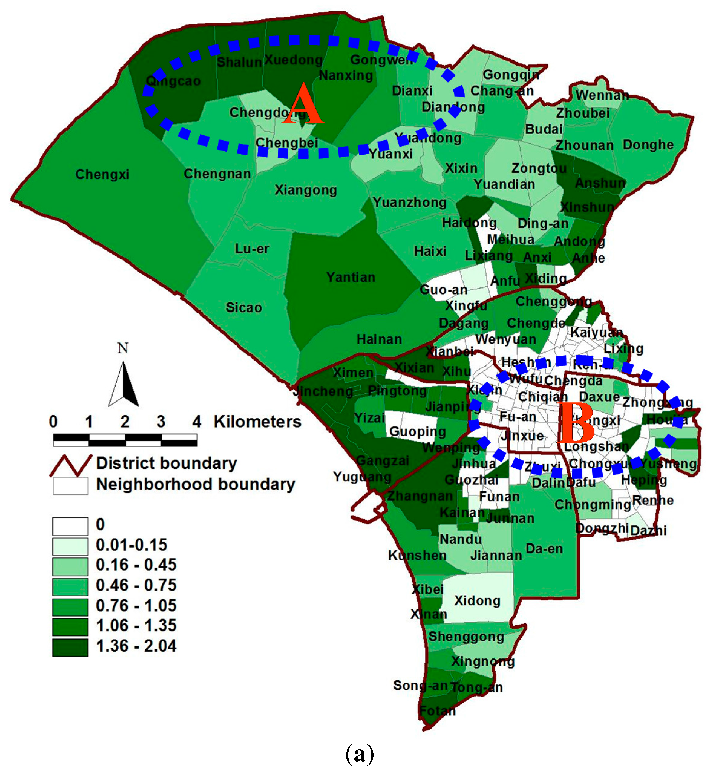
In the derivation of the surface temperature formula, the factors that most strongly affected the surface temperature in Tainan were the building coverage ratio and distance to the coast. Western Tainan is near the sea, resulting in areas with higher temperatures being concentrated in the city center and on the east and northeast sides of the city. Higher temperatures were evident each year. In the spatial transition diagram, a comparison across the three analysis periods revealed that the surface temperature is increasing in most areas (areas A and B in Figure 5). The city center exhibited a smaller change in surface temperature because development was saturated in this area and the change in land use types was smaller. In contrast, some of the neighborhoods (Andong, Anshun, Wennan and Xinshun) in the northern and eastern areas of the city exhibited relatively large changes in surface temperatures due to a continual increase in the area of developed urban land in these neighborhoods.
4.2.2. Surface Runoff
The surface runoff in 1993, 2008 and 2030 was 0.187, 0.190, and 0.202 m3/s, respectively, which reflected an increase in the percentage of impermeable surface area with increased urban development. Furthermore, the ranges and standard deviations in runoff across neighborhoods were large, which indicates that the impact of land use changes on surface runoff was severe. This result is consistent with the literature and is of importance to urban environmental planners.
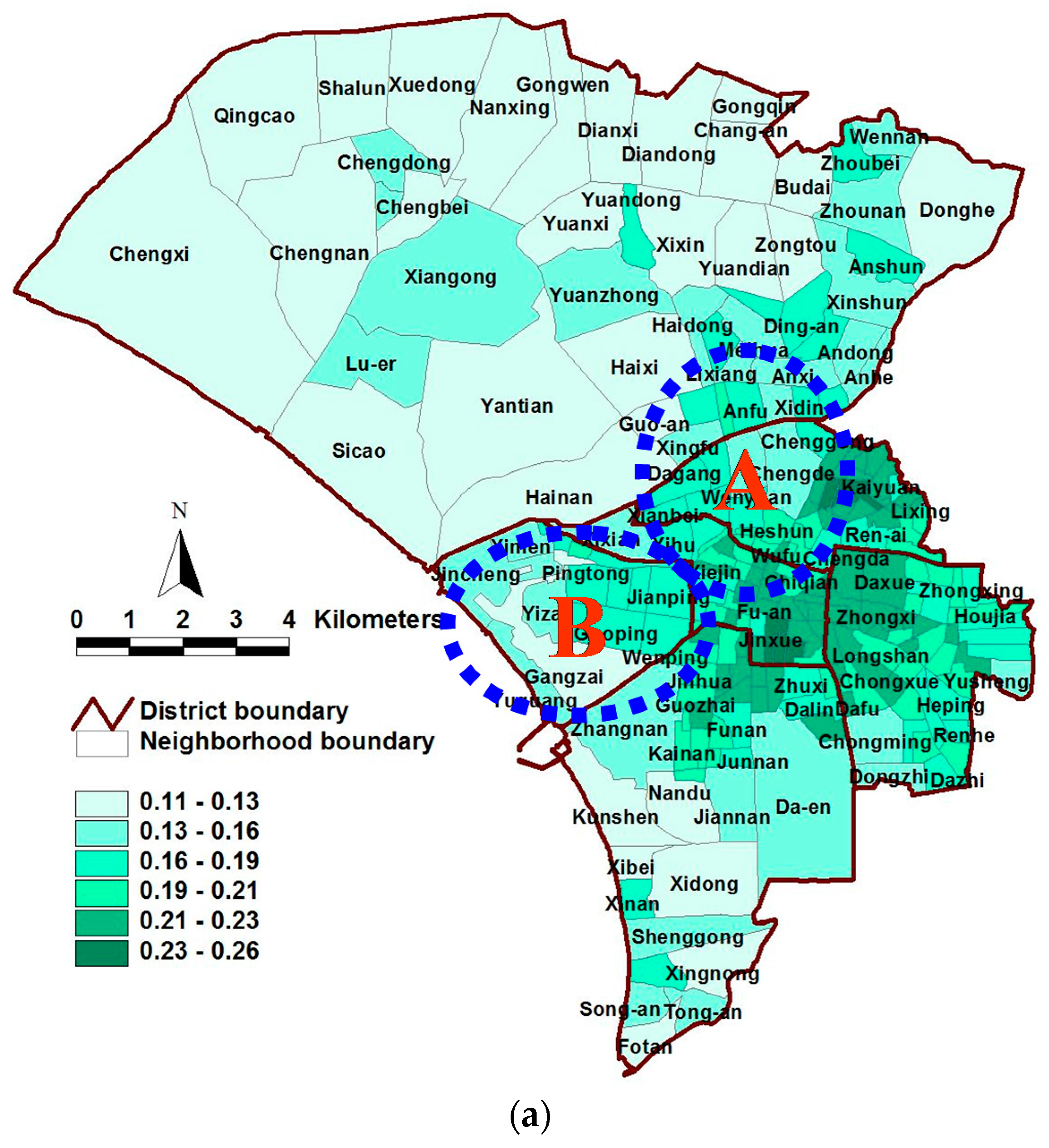
The surface runoff per neighborhood in Tainan was highest in the city center, before gradually decreasing toward the periphery. A comparison of the 1993, 2008 and 2030 runoff distributions revealed that the runoff increased significantly over time in the city center. The main settlements and core areas of urban growth in the peripheral Annan and South Districts also exhibited major surface runoff impacts. The spatial differentiation diagram shows that the changes in unit runoff were largest in the city center (area A in Figure 6; includes the Zhongzheng, Wufei, Fahua and Junwang neighborhoods) and Anping District (area B in Figure 5; includes the Yuping, Gangzai and Yizai neighborhoods) in the west. The land use data indicate that the land use types in the city center changed either from residential areas to business or from urban open space to business or parking lots, thereby increasing the impermeable surface area. This result explains the larger change in runoff per unit area in the city center. The Annan District north of the city center exhibited decreased runoff per unit area due to the urban open space in this district having been converted to green space and parks.
4.2.3. Habitat Diversity
The lowest diversity index value in the three annual periods was zero. This indicates that in each period, at least one of the neighborhoods in Tainan contained either no urban habitat or only a single type of habitat. Overall, the average, maximum and minimum values of urban habitat diversity in Tainan decreased over time, which indicates that urban development will result in decreases in urban habitat and diversity. However, measures taken by government departments, such as the protection of a wide range of urban habitats, establishment of urban parks and green landscaping of open space, indicate that differences in habitat diversity among the neighborhoods decreased.
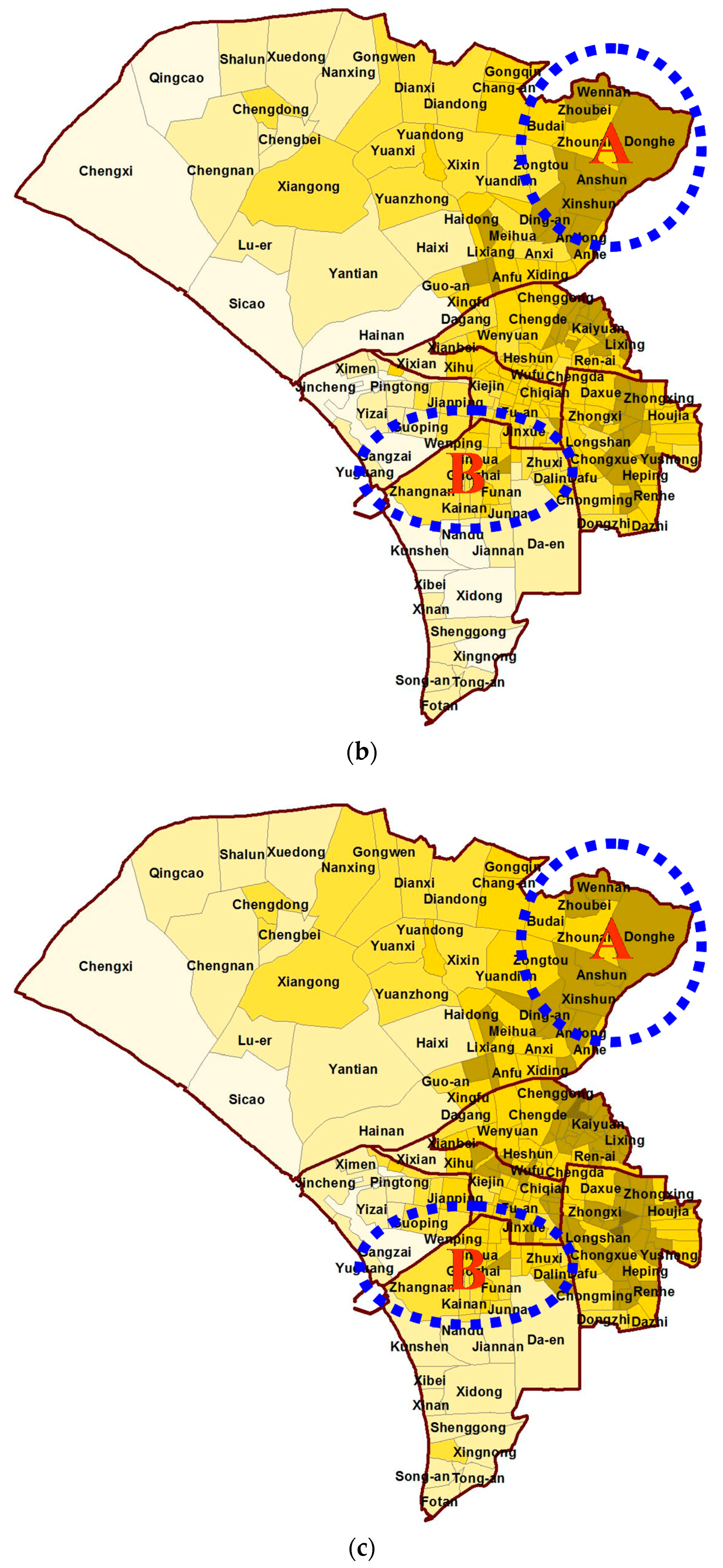
The values of the habitat diversity index in Tainan were lowest in the city center, before gradually increasing toward the periphery. The distribution chart clearly shows that habitat diversity was significantly lower in the city center (area B in Figure 7; includes the Gongzheng, Chiqian, Qingnian, Kaishan, Wanchang and Yintong neighborhoods) than in other areas. From 1993 to 2008, the areas exhibiting low diversity index values expanded from the city center. Outside of policy-designated protected or limited-development areas, the diversity index values primarily decreased during this period. For example, the diversity index values increased in protected coastal areas and the southern airport area, but decreased significantly in the Annan District in the north (area A in Figure 6; includes the Qingcao, Nanxing, Shalun and Xuedong neighborhoods). The land use status data indicated that a relatively high diversity of vegetation was present in the river estuary area (northwest of the city center). In 2030, some areas will lose their natural habitats due to urban development, which will reduce the habitat diversity. Simultaneously, diversity will increase in other areas because of urban parks and green space.
4.3. Spatial Cluster Analysis of the Impact on the Overall Natural Environment
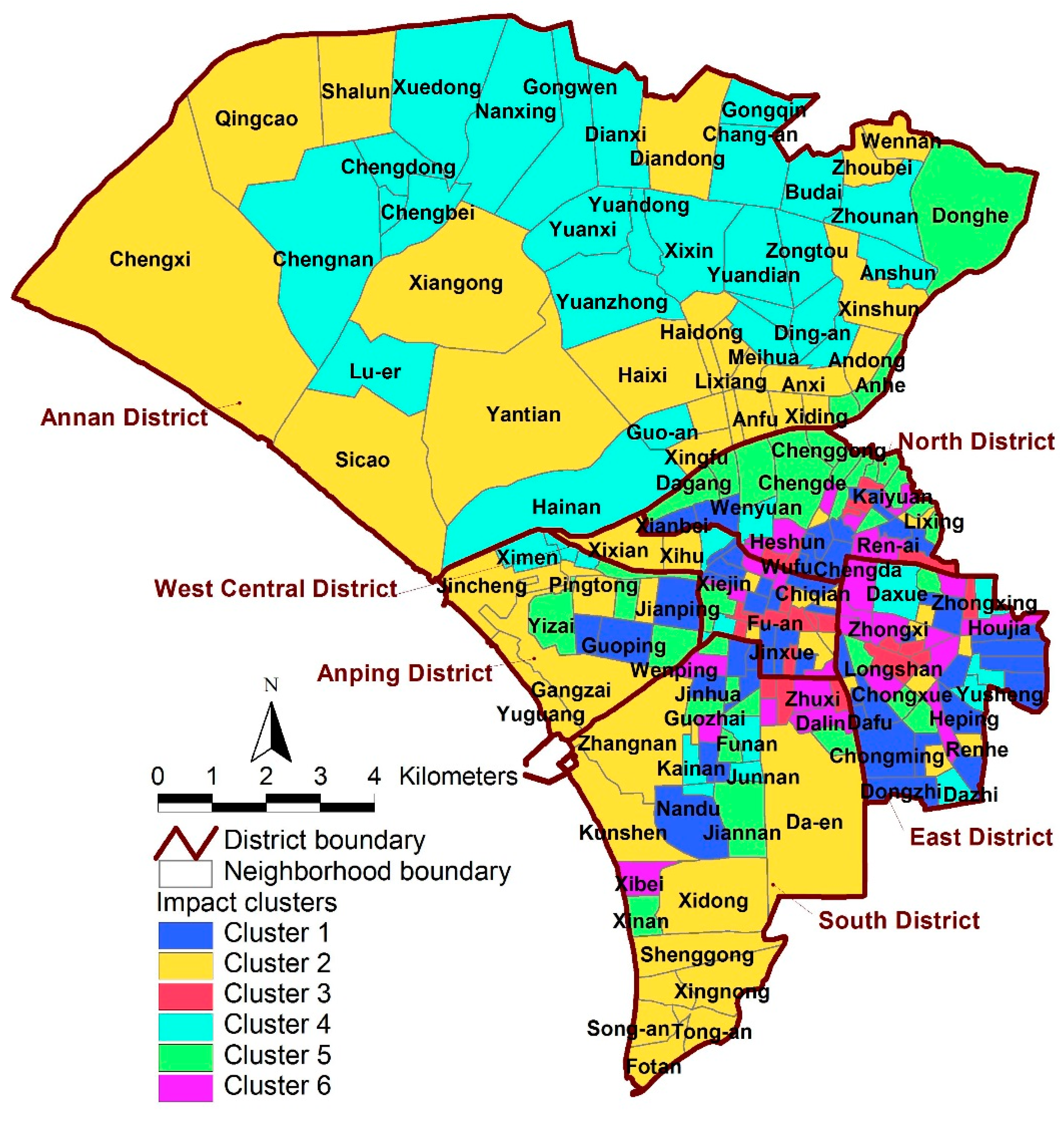
The cluster analysis resulted in the division of Tainan into six clusters based on three environmental impacts. Cluster 1 contained 50 neighborhoods, Cluster 2 contained 55 neighborhoods, Cluster 3 contained 24 neighborhoods, Cluster 4 contained 41 neighborhoods, Cluster 5 contained 34 neighborhoods and Cluster 6 contained 29 neighborhoods (Figure 8). The characteristics of each cluster are described below.
4.3.1. Cluster 1: Low-Impact Areas
The neighborhoods in Cluster 1 are relatively scattered and extensive. These neighborhoods are predominantly areas with relatively dense urban development, in which future land use change is predicted to be relatively moderate. Therefore, the changes in surface temperature, surface runoff, and habitat diversity in this cluster are predicted to not be significant.
4.3.2. Cluster 2: Positive-Impact Areas
Cluster 2 is concentrated in the protected coastal areas along the Yenshuei River and in the Wanli and Sishu areas in the South District. Land development is restricted in most of the neighborhoods in this cluster. Therefore, the vegetation coverage area and vegetation diversity are predicted to gradually increase in these neighborhoods, which will subsequently raise the habitat diversity index value. This result represents a positive impact on the environment. In this cluster, the change in habitat diversity is predicted to be relatively large, whereas changes in surface temperature and runoff are predicted to be relatively insignificant.
4.3.3. Cluster 3: Moderate- and High-Impact Areas
Cluster 3 consists of high-density development areas concentrated in and east of the city center. Although development in this area is saturated and new construction is limited, this intensive use of land continues to result in an increase in the impermeable surface area in this cluster. Predicted future environmental impacts in this area include large changes in surface temperatures and runoff and smaller changes in habitat diversity. Of these, the most serious environmental impact predicted in this cluster is an excessive increase in surface runoff. Therefore, the most important management actions in this cluster should include reducing the impermeable surface area and the use of more environmentally-friendly pavement materials.
4.3.4. Cluster 4: Moderate-Impact Areas
Cluster 4 is mainly agricultural. In the future, both the area of urban development and number of buildings are predicted to increase in the neighborhoods, with the heat-island impact being predicted to increase proportionally. Simultaneously, the villages in this area contain more areas and types of urban habitat types. Therefore, environmental impact management should focus on controlling the intensity of regional development and promoting technologies, such as green buildings and ecological engineering, to slow increases in surface temperature and maintain habitat diversity.
4.3.5. Cluster 5: Moderate- and Low-Impact Areas
Cluster 5 is concentrated north of the city center, which has undergone some development. Due to future urban expansion, this cluster is predicted to have increases in the impermeable surface area with subsequent decreases in habitat diversity. The predicted change in habitat diversity is large, while the predicted changes in surface temperature and runoff are relatively insignificant. Therefore, reducing the average building coverage ratio should be the most important management strategy in this cluster. In addition, to avoid excessive construction in the business area in the future, planners might also encourage or reward development that involves reduced building coverage ratios or increased green coverage through urban design.
4.3.6. Cluster 6: High-Impact Areas
Cluster 6 is concentrated east and south of the city center in high-density development areas. Although development in these areas is saturated and the construction of new buildings is limited, the intensive use of land continues to result in a decrease in vegetation and an increase in impermeable surface area. Predicted future environmental impacts include a large increase in surface temperature and increased variation in surface runoff. Management in this area should focus on afforestation. In addition to an increase in the area of parks and green space, replacing unnecessary impermeable surfaces in urban open spaces or public facilities with green pavements will reduce surface runoff and decrease surface temperatures.
4.4. Sustainable Urbanization Strategies
In the future, larger changes in surface temperature are predicted north of the city center, while smaller changes are predicted in the city center. Larger changes in surface runoff are predicted in the city center, while smaller predicted changes are concentrated in the Annan District north of the city center. Habitat diversity is predicted to change extensively in three clusters and only slightly in one cluster. The government of Tainan should create strategies to mitigate these consequences, focusing on the city center, which has better infrastructure for maintaining and improving the quality of existing facilities and promoting the greening of open spaces. In addition, in conjunction with the comprehensive review of urban planning and design specifications, the green surface area associated with public buildings and new developments should be increased to increase the number of urban habitats and decrease surface runoff. In both the Heshun traditional settlement and the future centers of new growth (such as Haiweiliao, Benyuanliao and Changan in the Annan District), the basic infrastructure necessary for urban life and productivity should be provided. To minimize the impact of urban development on the natural environment, natural areas and permeable pavement should be used in planning and design to increase the permeable surface area and the green coverage ratio, decrease surface runoff, and maintain habitat diversity.
5. Conclusions
Changes in land use in a city are unavoidable during urban development. Most land use changes will have a negative impact on the natural environment. The integrated simulation-based evaluation method proposed in this present study includes spatial, dynamic and normative features. For rapidly urbanizing areas similar to Tainan, this method could effectively simulate the impact of future urban development patterns and processes on the natural environment, thereby generating useful information, such as the predicted scale and spatial distribution of environmental impacts. This information can improve urban growth plans and be used to formulate new urban development strategies and action plans. It is important for urban managers to develop management strategies and development plans, which allow urban resources to be used more effectively and reduce the environmental impacts of urban development. In conjunction with GIS techniques, the use of cluster analysis to examine the characteristics of these environmental impacts reveals patterns and trends in the spatial distribution of each type of impact, which is helpful in the overall assessment of environmental impact. Urban planners can apply the strategies of retaining existing natural open spaces in urban districts and increasing areas of green space with ecological functions in urban areas through a standardized review of urban design and the implementation of a comprehensive urban planning process.
Acknowledgments
The authors would like to thank the Ministry of Science and Technology of the Republic of China, Taiwan, for financially supporting this research under contract MOST-96-2415-H-006-007-MY2 and MOST-105-2410-H-507-009-MY2.
Author Contributions
This study represents the combination of work from two authors. Hsing-Fu Kuo performed research, analyzed the data and wrote the paper; while Ko-Wan Tsou contributed to the research design. All authors read and approved the final manuscript.
Conflicts of Interest
The authors declare no conflicts of interest.
References
- United Nations. World Population Prospects: The 2017 Revision; United Nations: New York, NY, USA, 2017. [Google Scholar]
- Haase, D.; Nuissl, H. Does urban sprawl drive changes in the water balance and policy? The case of Leipzig (Germany) 1870–2003. Landsc. Urban Plan. 2007, 80, 1–13. [Google Scholar] [CrossRef]
- He, C.Y.; Okada, N.; Zhang, Q.F.; Shi, P.J.; Li, J.G. Modelling dynamic urban expansion processes incorporating a potential model with cellular automata. Landsc. Urban Plan. 2008, 86, 79–91. [Google Scholar] [CrossRef]
- Pauleit, S.; Duhme, F. Assessing the environmental performance of land cover types for urban planning. Landsc. Urban Plan. 2000, 52, 1–20. [Google Scholar] [CrossRef]
- Zhao, C.J.; Fu, G.B.; Liu, X.M.; Fu, F. Urban planning indicators, morphology and climate indicators: A case study for a north-south transect of Beijing, China. Build. Environ. 2011, 46, 1174–1183. [Google Scholar] [CrossRef]
- Hasse, J.E.; Lathrop, R.G. Land resource impact indicators of urban sprawl. Appl. Geogr. 2003, 23, 159–175. [Google Scholar] [CrossRef]
- Lambin, E.F.; Meyfroidt, P. Land use transitions: Socio-ecological feedback versus socio-economic change. Land Use Policy 2010, 27, 108–118. [Google Scholar] [CrossRef]
- Zofio, J.L.; Prieto, A.M. Environmental efficiency and regulatory standards: The case of CO2 emissions from OECD industries. Resour. Energy Econ. 2001, 23, 63–83. [Google Scholar] [CrossRef]
- Kattwinkel, M.; Biedermann, R.; Kleyer, M. Temporary conservation for urban biodiversity. Biol. Conserv. 2011, 144, 2335–2343. [Google Scholar] [CrossRef]
- Kohsaka, R. Developing biodiversity indicators for cities: Applying the DPSIR model to Nagoya and integrating social and ecological aspects. Ecol. Res. 2010, 25, 925–936. [Google Scholar] [CrossRef]
- Fox, D.M.; Witz, E.; Blanc, V.; Soulié, C.; Penalver-Navarro, M.; Dervieux, A. A case study of land cover change (1950–2003) and runoff in a Mediterranean catchment. Appl. Geogr. 2012, 32, 810–821. [Google Scholar] [CrossRef]
- Tang, J.; Wang, L.; Yao, Z. Analyses of urban landscape dynamics using multi-temporal satellite images: A comparison of two petroleum-oriented cities. Landsc. Urban Plan. 2008, 87, 269–278. [Google Scholar] [CrossRef]
- Whitford, V.; Ennos, A.R.; Handley, J.F. “City form and natural process”—Indicators for the ecological performance of urban areas and their application to Merseyside, UK. Landsc. Urban Plan. 2001, 57, 91–103. [Google Scholar] [CrossRef]
- Zhang, B.A.; Xie, G.D.; Zhang, C.Q.; Zhang, J. The economic benefits of rainwater-runoff reduction by urban green spaces: A case study in Beijing, China. J. Environ. Manag. 2012, 100, 65–71. [Google Scholar] [CrossRef] [PubMed]
- Hoppe, P. Different aspects of assessing indoor and outdoor thermal comfort. Energy Build. 2002, 34, 661–665. [Google Scholar] [CrossRef]
- Pauleit, S.; Ennos, R.; Golding, Y. Modeling the environmental impacts of urban land use and land cover change—A study in Merseyside, UK. Landsc. Urban Plan. 2005, 71, 295–310. [Google Scholar] [CrossRef]
- Svensson, M.K.; Eliasson, I. Diurnal air temperatures in built-up areas in relation to urban planning. Landsc. Urban Plan. 2002, 61, 37–54. [Google Scholar] [CrossRef]
- Zeller, V.; Bahn, M.; Aichner, M.; Tappeiner, U. Impact of land-use change on nitrogen mineralization in subalpine grasslands in the Southern Alps. Biol. Fertil. Soils 2000, 31, 441–448. [Google Scholar] [CrossRef]
- Christidis, N.; Stott, P.A.; Hegerl, G.C.; Betts, R.A. The role of land use change in the recent warming of daily extreme temperatures. Geophys. Res. Lett. 2013, 40, 589–594. [Google Scholar] [CrossRef] [Green Version]
- Guneralp, B.; Seto, K.C. Futures of global urban expansion: Uncertainties and implications for biodiversity conservation. Environ. Res. Lett. 2013, 8, 1–10. [Google Scholar] [CrossRef]
- Kumar, D.S.; Arya, D.S.; Vojinovic, Z. Modeling of urban growth dynamics and its impact on surface runoff characteristics. Comput. Environ. Urban Syst. 2013, 41, 124–135. [Google Scholar] [CrossRef]
- Barredo, J.I.; Kasanko, M.; McCormick, N.; Lavalle, C. Modelling dynamic spatial processes: Simulation of urban future scenarios through cellular automata. Landsc. Urban Plan. 2003, 64, 145–160. [Google Scholar] [CrossRef]
- Cheng, J.Q.; Masser, I. Understanding spatial and temporal processes of urban growth: Cellular automata modelling. Environ. Plan. B Plan. Des. 2004, 31, 167–194. [Google Scholar] [CrossRef]
- Al-shalabi, M.; Billa, L.; Pradhan, B.; Mansor, S.; Al-Sharif, A.A.A. Modelling urban growth evolution and land-use changes using GIS based cellular automata and SLEUTH models: The case of Sana’a metropolitan city, Yemen. Environ. Earth Sci. 2013, 70, 425–437. [Google Scholar] [CrossRef] [Green Version]
- Mao, X.Y.; Meng, J.J.; Xiang, Y.Y. Cellular automata-based model for developing land use ecological security patterns in semi-arid areas: A case study of Ordos, Inner Mongolia, China. Environ. Earth Sci. 2013, 70, 269–279. [Google Scholar] [CrossRef]
- Sakieh, Y.; Amiri, B.J.; Danekar, A.; Feghhi, J.; Dezhkam, S. Simulating urban expansion and scenario prediction using a cellular automata urban growth model, SLEUTH, through a case study of Karaj City, Iran. J. Hous. Built Environ. 2015, 30, 591–611. [Google Scholar] [CrossRef]
- Badwi, I.M.; El-Barmelgy, M.M.; Ouf, A.S.E.-D. Modeling and Simulation of Greater Cairo Region Urban Dynamics Using SLEUTH. J. Urban Plan. Dev. 2015, 141, 1–19. [Google Scholar] [CrossRef]
- Baynes, T.M. Complexity in Urban Development and Management. J. Ind. Ecol. 2009, 13, 214–227. [Google Scholar] [CrossRef]
- Hua, L.Z.; Tang, L.N.; Cui, S.H.; Yin, K. Simulating Urban Growth Using the SLEUTH Model in a Coastal Peri-Urban District in China. Sustainability 2014, 6, 3899–3914. [Google Scholar] [CrossRef]
- Jantz, C.A.; Goetz, S.J.; Donato, D.; Claggett, P. Designing and implementing a regional urban modeling system using the SLEUTH cellular urban model. Comput. Environ. Urban Syst. 2010, 34, 1–16. [Google Scholar] [CrossRef]
- Kuo, H.F.; Tsou, K.W. Application of Environmental Change Efficiency to the Sustainability of Urban Development at the Neighborhood Level. Sustainability 2015, 7, 10479–10498. [Google Scholar] [CrossRef]
- Sandstrom, U.G.; Angelstam, P.; Khakee, A. Urban comprehensive planning—Identifying barriers for the maintenance of functional habitat networks. Landsc. Urban Plan. 2006, 75, 43–57. [Google Scholar] [CrossRef]
- Wagendorp, T.; Gulinck, H.; Coppin, P.; Muys, B. Land use impact evaluation in life cycle assessment based on ecosystem thermodynamics. Energy 2006, 31, 112–125. [Google Scholar] [CrossRef]
- Ding, H.Y.; Shi, W.Z. Land-use/land-cover change and its influence on surface temperature: A case study in Beijing City. Int. J. Remote Sens. 2013, 34, 5503–5517. [Google Scholar] [CrossRef]
- Leao, S.; Bishop, I.; Evans, D. Spatial-temporal model for demand and allocation of waste landfills in growing urban regions. Comput. Environ. Urban Syst. 2004, 28, 353–385. [Google Scholar] [CrossRef]
- Han, H.; Hwang, Y.; Ha, S.R.; Kim, B.S. Modeling Future Land Use Scenarios in South Korea: Applying the IPCC Special Report on Emissions Scenarios and the SLEUTH Model on a Local Scale. Environ. Manag. 2015, 55, 1064–1079. [Google Scholar] [CrossRef] [PubMed]
- Bihamta, N.; Soffianian, A.; Fakheran, S.; Gholamalifard, M. Using the SLEUTH Urban Growth Model to Simulate Future Urban Expansion of the Isfahan Metropolitan Area, Iran. J. Indian Soc. Remote Sens. 2015, 43, 407–414. [Google Scholar] [CrossRef]
- Rienow, A.; Goetzke, R. Supporting SLEUTH—Enhancing a cellular automaton with support vector machines for urban growth modeling. Comput. Environ. Urban Syst. 2014, 49, 66–81. [Google Scholar] [CrossRef]
- Dietzel, C.; Clarke, K.C. Toward Optimal Calibration of the SLEUTH Land Use Change Model. Trans. GIS 2007, 11, 29–45. [Google Scholar] [CrossRef]
- Jantz, C.A.; Goetz, S.J.; Shelley, M.K. Using the SLEUTH urban growth model to simulate the impacts of future policy scenarios on urban land use in the Baltimore-Washington metropolitan area. Environ. Plan. B Plan. Des. 2004, 31, 251–271. [Google Scholar] [CrossRef]
- Lee, D.R.; Sallee, G.T. A Method of Measuring Shape. Geogr. Rev. 1970, 60, 555–563. [Google Scholar] [CrossRef]
- Silva, E.A.; Clarke, K.C. Complexity, emergence and cellular urban models: Lessons learned from applying sleuth to two Portuguese metropolitan areas. Eur. Plan. Stud. 2005, 13, 93–116. [Google Scholar] [CrossRef]
- Shi, Y.S.; Wu, J.; Shi, S.Z. Study of the Simulated Expansion Boundary of Construction Land in Shanghai Based on a SLEUTH Model. Sustainability 2017, 9, 15. [Google Scholar] [CrossRef]
- Osman, T.; Divigalpitiya, P.; Arima, T. Using the SLEUTH urban growth model to simulate the impacts of future policy scenarios on land use in the Giza Governorate, Greater Cairo Metropolitan region. Int. J. Urban Sci. 2016, 20, 407–426. [Google Scholar] [CrossRef]
- Sakieh, Y.; Amiri, B.; Danekar, A.; Feghhi, J.; Dezhkam, S. Scenario-based evaluation of urban development sustainability: An integrative modeling approach to compromise between urbanization suitability index and landscape pattern. Environ. Dev. Sustain. 2015, 17, 1343–1365. [Google Scholar] [CrossRef]
- Lin, H.T.; Sun, C.Y.; Kuo, H.C.; Lee, K.P. A study of urban populations and the urban heat island intensity in Tainan. City Plan. 2005, 32, 83–97. [Google Scholar]
- Lin, F.R.; Wu, N.J.; Tsay, T.K. Applications of Cluster Analysis and Pattern Recognition for Typhoon Hourly Rainfall Forecast. Adv. Meteorol. 2017, 2017, 1–17. [Google Scholar] [CrossRef]
- Javadi, S.; Hashemy, S.M.; Moha mmadi, K.; Howard, K.W.F.; Neshat, A. Classification of aquifer vulnerability using K-means cluster analysis. J. Hydrol. 2017, 549, 27–37. [Google Scholar] [CrossRef]
- Akin, D.; Dokmeci, V. Cluster Analysis of Interregional Migration in Turkey. J. Urban Plan. Dev. 2015, 141, 1–13. [Google Scholar] [CrossRef]
- Jain, A.K. Data clustering: 50 years beyond K-means. Pattern Recognit. Lett. 2010, 31, 651–666. [Google Scholar] [CrossRef]
- Li, Y.-S.; Chuang, Y.-C. Neighborhood Effects on an Individual’s Health Using Neighborhood Measurements Developed by Factor Analysis and Cluster Analysis. J. Urban Health Bull. N. Y. Acad. Med. 2009, 86, 5–18. [Google Scholar] [CrossRef] [PubMed]
- Scherer, M.; Weidmann, U. Differences in Travel Behavior and Demand Potential of Tram- and Bus-Based Neighborhoods Evidence from a Cluster Analysis. Transp. Res. Rec. 2011, 2217, 1–10. [Google Scholar] [CrossRef]
Figure 1.
Location of the study area.
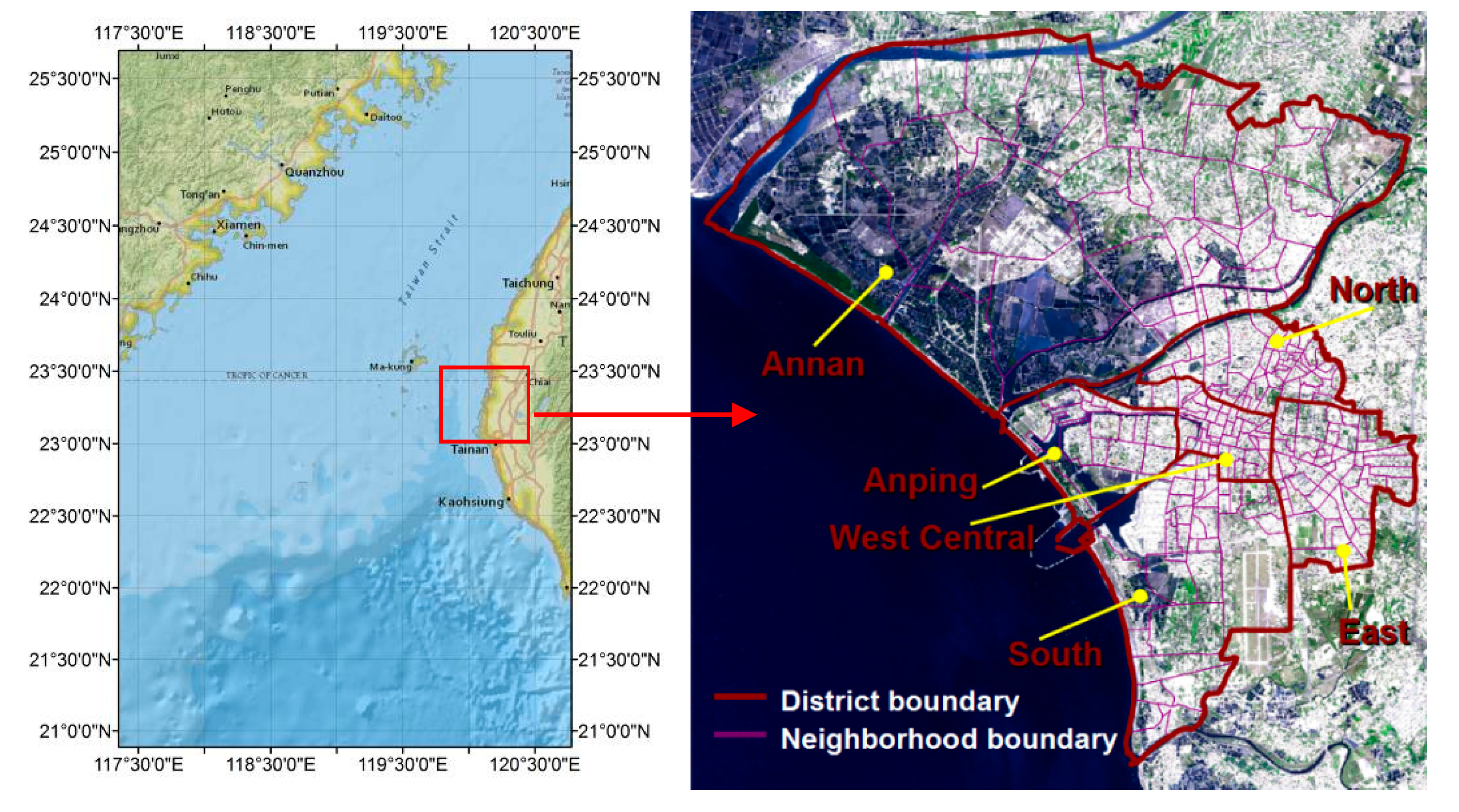
Figure 2.
Framework for simulating land use changes and environmental impact patterns.
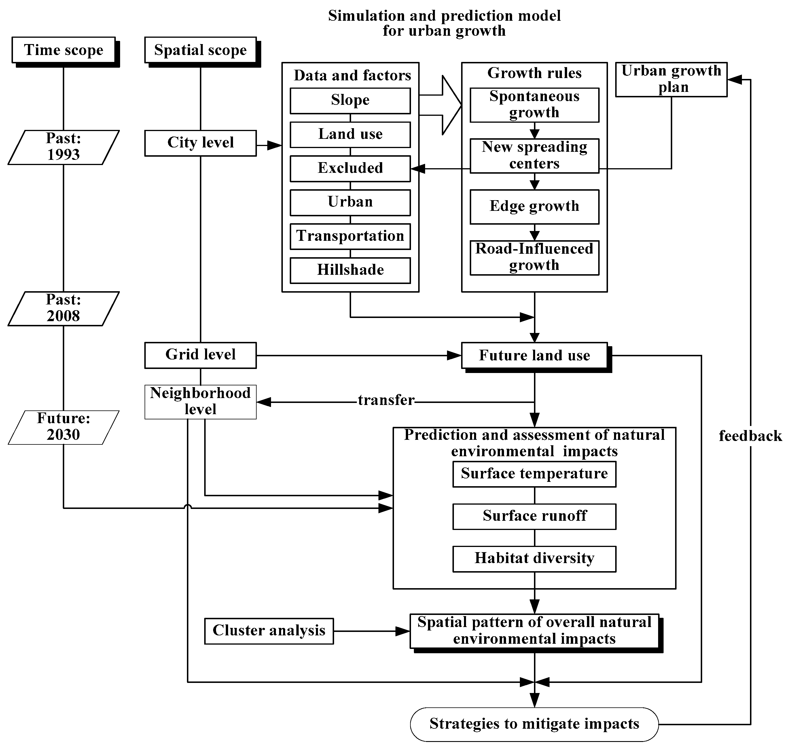
Figure 3.
Example of processing of data. (a) City level land use in 2008; (b) Grid level land use for simulation at 20-m resolution in 2008; (c) Neighborhood boundaries in 2008; (d) Grid level land use within neighborhoods in 2008; (e) Predicted habitat diversity of Yuandian and Zongtou in 2030; (f) Predicted surface temperatures of Yuandian and Zongtou in 2030.
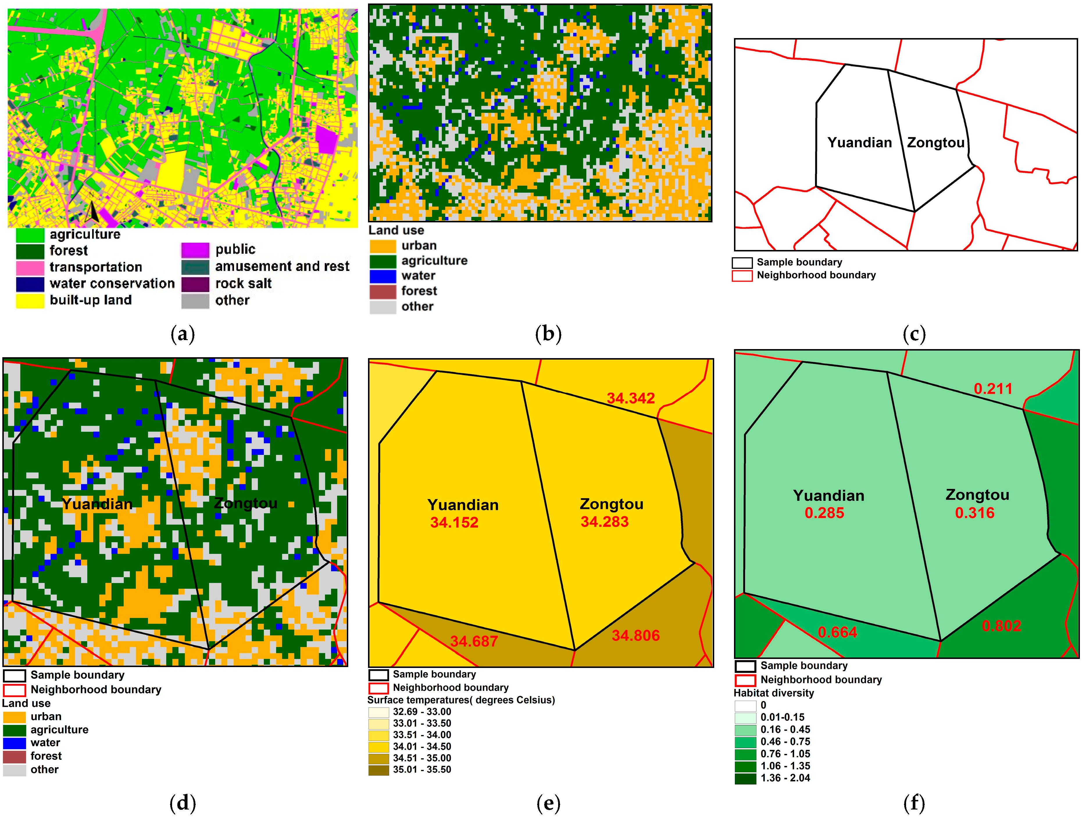
Figure 4.
Distribution of land use in 2008 and predicted land use in 2030. (a) 2008; (b) 2030.

Figure 5.
Spatial distribution of predicted surface temperatures in 2030, in comparison with the data in 1993 and 2008. (a) 1993; (b) 2008; (c) 2030.
Figure 5.
Spatial distribution of predicted surface temperatures in 2030, in comparison with the data in 1993 and 2008. (a) 1993; (b) 2008; (c) 2030.
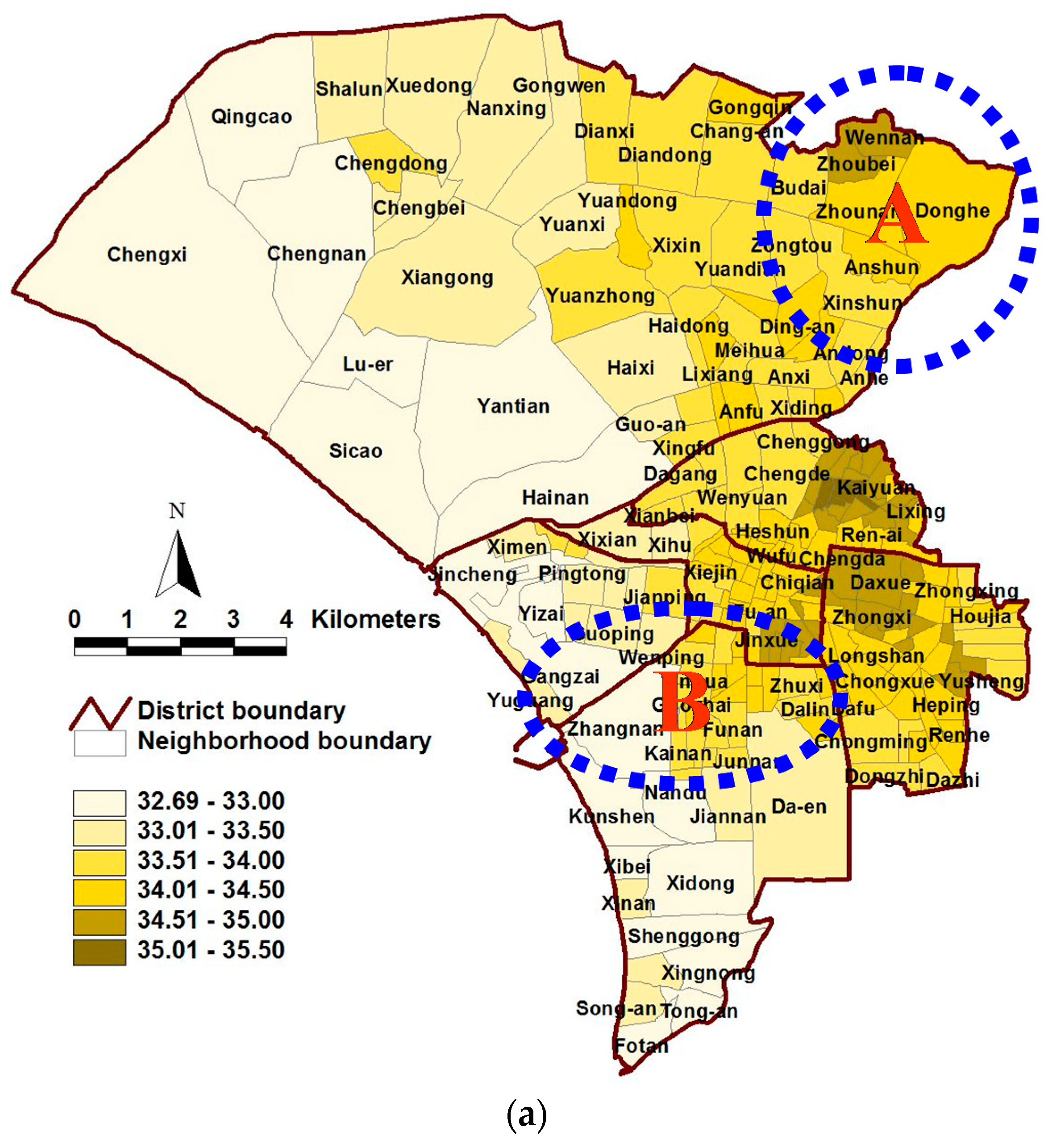

Figure 6.
Spatial distribution of predicted surface runoff in 2030, in comparison with the data in 1993 and 2008. (a) 1993; (b) 2008; (c) 2030.
Figure 6.
Spatial distribution of predicted surface runoff in 2030, in comparison with the data in 1993 and 2008. (a) 1993; (b) 2008; (c) 2030.

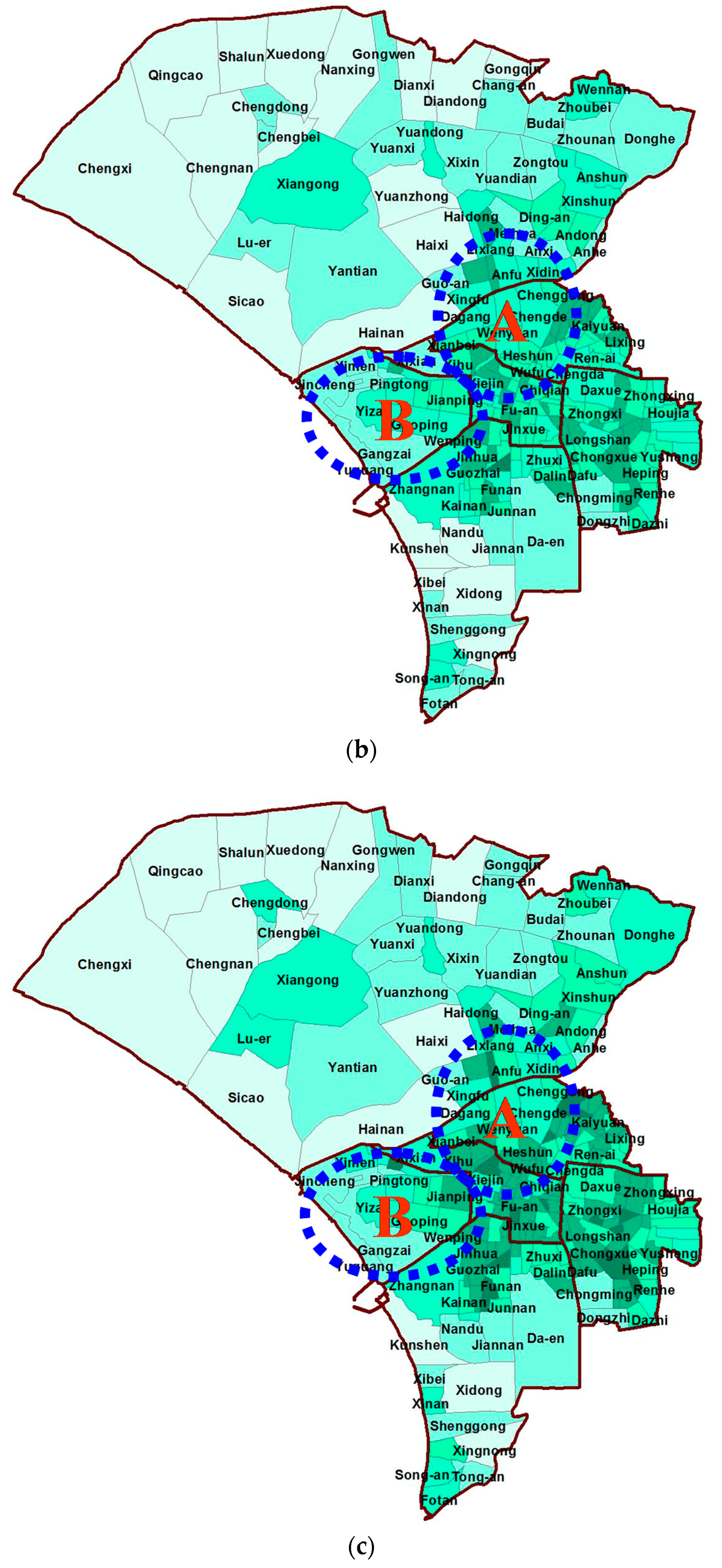
Figure 7.
Spatial distribution of predicted habitat diversity in 2030, in comparison with the data in 1993 and 2008. (a) 1993; (b) 2008; (c) 2030.
Figure 7.
Spatial distribution of predicted habitat diversity in 2030, in comparison with the data in 1993 and 2008. (a) 1993; (b) 2008; (c) 2030.

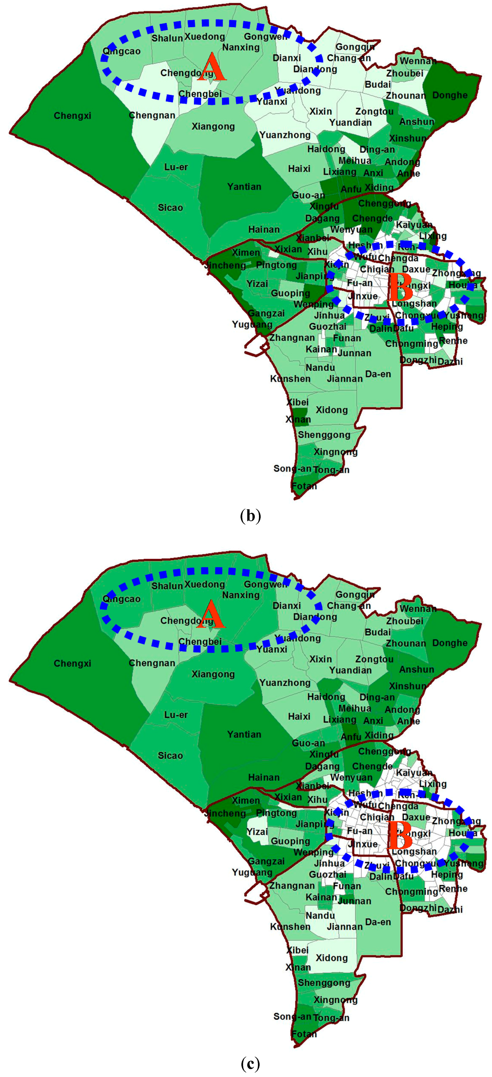
Figure 8.
Spatial distribution of clusters resulting from the analysis of overall environmental impacts.
Figure 8.
Spatial distribution of clusters resulting from the analysis of overall environmental impacts.


Table 1.
Layer and data definition for the data used in the model.
| Layers | Definition | Data Source/Resolution, Scale | Used Research Area Unit |
|---|---|---|---|
| Slope | The slope is derived from a digital elevation model (DEM), cell values are in percent slope gradient. Pixel value range: 0–100 | Generated from 20-m DEM of the Council of Agriculture/20 m | degree |
| Land Use | Land uses are assigned to five classes: urban development, agricultural land, forest, water, and other uses. | Land Use Investigation of Taiwan, 1993, 2008/1:5000 | - |
| Excluded | A map showing areas excluded from urbanization. | Urban growth plan of Tainan/20 m | - |
| Urban | Built-up land extent for the year. The model simply requires a binary urban/nonurban classification. Pixel value range: 0 = nonurban 0 < n < 256 = urban | 1985: Topographic map, 1985/1:25,000 | - |
| 1993: Land Use Investigation of Taiwan, 1993/1:5000 | - | ||
| 2008: Land Use Investigation of Taiwan, 2008/1:5000 | - | ||
| 2014: Taiwan Electronic Map, 2014/1:5000 | - | ||
| Transportation | Road network images. It should be binary (road/non-road). Binary: 0 = non-road, 0 < n < 256 = road | 1985: Topographic Map, 1985 | - |
| 1993: Land Use Investigation of Taiwan, 1993/1:5000 | - | ||
| 2008: Land Use Investigation of Taiwan, 2008/1:5000 | - | ||
| 2014: Taiwan Electronic Map, 2014/1:5000 | - | ||
| Hillshade | The hillshade is derived from a digital elevation model (DEM) and must be a grayscale image. | Generated from 20-m DEM from the Council of Agriculture/20 m | - |
| Surface temperature | Average surface temperature | 1. Land Use Investigation of Taiwan, 1993, 2008/1:5000 2. A predicted result for urban growth in 2030/20 m | °C |
| Surface runoff | Total volume of overland flow draining off the land | 1. Land Use Investigation of Taiwan, 1993, 2008/1:5000 2. A predicted result for urban growth in 2030/20 m | m3/s |
| Habitat diversity | Shannon–Weaver index | 1. Land Use Investigation of Taiwan, 1993, 2008/1:5000 2. A predicted result for urban growth in 2030/20 m | - |
Table 2.
Statistical data on environmental impacts.
| Indicators | Year(s) | Mean | Std. Dev. | Range | Min | Max |
|---|---|---|---|---|---|---|
| Surface temperature (°C) | 1993 | 34.017 | 0.473 | 1.618 | 32.692 | 34.310 |
| 2008 | 34.049 | 0.509 | 2.129 | 32.751 | 34.880 | |
| 2030 | 34.245 | 0.536 | 2.259 | 32.771 | 35.030 | |
| 1993–2008 | 0.032 | 0.308 | 1.603 | −0.834 | 0.769 | |
| 2008–2030 | 0.196 | 0.095 | 0.621 | 0.010 | 0.630 | |
| Surface runoff (m3/s) | 1993 | 0.187 | 0.037 | 0.145 | 0.111 | 0.256 |
| 2008 | 0.190 | 0.031 | 0.126 | 0.115 | 0.241 | |
| 2030 | 0.202 | 0.032 | 0.125 | 0.120 | 0.245 | |
| 1993–2008 | 0.003 | 0.018 | 0.101 | −0.045 | 0.056 | |
| 2008–2030 | 0.202 | 0.032 | 0.125 | 0.120 | 0.245 | |
| Habitat diversity | 1993 | 0.394 | 0.539 | 2.040 | 0.000 | 2.040 |
| 2008 | 0.375 | 0.366 | 1.516 | 0.000 | 1.516 | |
| 2030 | 0.280 | 0.337 | 1.260 | 0.000 | 1.260 | |
| 1993–2008 | 0.178 | 0.318 | 1.776 | −0.681 | 1.095 | |
| 2008–2030 | −0.096 | 0.319 | 1.960 | −1.267 | 0.693 |
© 2017 by the authors. Licensee MDPI, Basel, Switzerland. This article is an open access article distributed under the terms and conditions of the Creative Commons Attribution (CC BY) license (http://creativecommons.org/licenses/by/4.0/).
Share and Cite
MDPI and ACS Style
Kuo, H.-F.; Tsou, K.-W. Modeling and Simulation of the Future Impacts of Urban Land Use Change on the Natural Environment by SLEUTH and Cluster Analysis. Sustainability 2018, 10, 72. https://doi.org/10.3390/su10010072
AMA Style
Kuo H-F, Tsou K-W. Modeling and Simulation of the Future Impacts of Urban Land Use Change on the Natural Environment by SLEUTH and Cluster Analysis. Sustainability. 2018; 10(1):72. https://doi.org/10.3390/su10010072
Chicago/Turabian StyleKuo, Hsing-Fu, and Ko-Wan Tsou. 2018. "Modeling and Simulation of the Future Impacts of Urban Land Use Change on the Natural Environment by SLEUTH and Cluster Analysis" Sustainability 10, no. 1: 72. https://doi.org/10.3390/su10010072
Note that from the first issue of 2016, this journal uses article numbers instead of page numbers. See further details here.