Coping with Complex Environmental and Societal Flood Risk Management Decisions: An Integrated Multi-criteria Framework


Abstract
: During recent years, a great deal of attention has been focused on the financial risk management of natural disasters. One reason behind is that the economic losses from floods, windstorms, earthquakes and other disasters in both the developing and developed countries are escalating dramatically. It has become apparent that an integrated water resource management approach would be beneficial in order to take both the best interests of society and of the environment into consideration. One improvement consists of models capable of handling multiple criteria (conflicting objectives) as well as multiple stakeholders (conflicting interests). A systems approach is applied for coping with complex environmental and societal risk management decisions with respect to flood catastrophe policy formation, wherein the emphasis is on computer-based modeling and simulation techniques combined with methods for evaluating strategies where numerous stakeholders are incorporated in the process. The resulting framework consists of a simulation model, a decision analytical tool, and a set of suggested policy strategies for policy formulation. The framework will aid decision makers with high risk complex environmental decisions subject to significant uncertainties.1. Introduction
Flooding is a natural state for all river systems. A river normally has a floodplain, i.e., an area of land onto which excess volumes of water will overspill once the channel reaches its maximum capacity. However, populating the floodplains, redirecting the river systems as well as changing the land use, results in a number of phenomena affecting the people and properties at risk of flooding. In this paper we focus on how to develop and investigate policies for minimizing damage caused by natural catastrophes as well as maximizing the potential for recovery in the aftermath of such a catastrophe.
In particular, we discuss management of policies for flood prone areas and the main rationale behind the work is to design a comprehensive framework assisted by modern methods from the areas of systems, risk, and decision analysis for evaluating feasible strategies for coping with floods in inhabited areas. Of special concern, and what constitutes the novelty of our approach, is that policy- and decision-makers together with other stakeholder groups, possibly having conflicting views and opinions, can jointly discuss the outcomes of policies and perform advanced multi-way sensitivity analyses on policy decisions whenever uncertain values are present, which is almost always the case. Further, attention is paid to emerging economies and developing countries, where insufficient management of natural catastrophes can have devastating effects on the quality of life. Floods change from natural states into disasters by the complex interactions of sub-systems surrounding the river, such as environmental and social processes [1]. These effects are further emphasized when the climate changes, since the adaptation to altered circumstances is comparatively slow, cf., e.g., [2,3]. Globally, the precipitation has increased in some areas and decreased in others, causing drought in some areas and flooding in others. Moreover, polar ice melts and as a consequence the sea level will rise and wetland and floodplains will become more vulnerable to floods [4]. For example, Tol et al. [5] predicts that in the Meuse River, a 2 °C global temperature increase combined with a 10 per cent increase in precipitation would more than double the average damage caused by flooding. For example, there has been a nearly 70 percent increase in frequency of water related natural disasters during the last decade, according to the World Disasters Report [6]. Consequently, governments of both developed and developing countries are concerned with increasing post-disaster liabilities in recovery of infrastructure damage and compensation to victims.
Although the actual monetary value of property damage from an event such as a flood may be higher in an industrialized country, the relative monetary loss is on average much greater in less developed countries. Poverty itself is a contributor to increased vulnerability [7]. Furthermore, inadequate housing and high population densities on sensitive land contribute to higher losses from natural disasters. This is further complicated by developing regions often experiencing difficulties in raising funds for the recovery processes and that development projects are disrupted. It has therefore been recognized that societies must move from focusing on post-disaster recovery approaches towards the use of more prevention and preparation mechanisms as well as adopting a more interdisciplinary approach [8]. Bangladesh, Vietnam, and Mozambique are countries where disasters often strike. For instance, more than 15 major floods occurred in the 20th century in Bangladesh. Three of the floods had catastrophic consequences. A more recent flood in 2004 was also severe and more than a third of the country was inundated, rural infrastructure and large areas of agricultural land were destroyed and many people became homeless [9,10]. Moreover, two million people became homeless in Mozambique after severe floods in 2000 an 2001 [11].
Nevertheless, equity and fairness in the distribution of both burdens and benefits are vital in order to obtain an effective risk management strategy as well as for reaching a sustainable development process. This also requires the involvement of stakeholders during the decision making process on all levels. Water resource planners and managers today must consider the interests and goals of several stakeholders. Taking diverse stakeholder interests into account are often an important aspect for the achievement and success of risk management policy strategies [12,13].
2. Flood Risk Assessment
It has for some time been recognized that poverty reduction and disaster risk management needs to be integrated [14] and Riebsame [15] called for a new approach in development planning already in 1990. One category of flood research is concerned with detailed flood behavior, such as frequency, discharge, and ground elevation for estimating flood depth, flood elevation, and velocity [16,17]. These analysis models include representations of the processes in river catchments and focus on the flow and parameters concerning the actual river. While important, the work in this category is too narrow for the purposes of the proposed framework, since it does not take into consideration the actual flood event and the damage it causes.
Another approach is concentrated on the actual effects of flooding. It is, in turn, divided into flood loss estimation analysis and flood hazard analysis, see for example [18,19]. Dutta and Herath [20] present a different type of tool which integrates flood hazard analysis with flood loss estimation and they suggest a GIS based methodology approach which considers three kinds of direct flood damages, i.e., urban, rural, and infrastructure damages. Flood loss estimation models vary in complexity regarding GIS data, from only using a simple digital elevation map (DEM) to using high-resolution raster DEM, which are becoming increasingly available, cf. [21]. A method for obtaining more exact data is suggested in Pham [22], achieved by using three-dimensional satellite data. The models above perform thorough investigations on the river flow and some also investigate the damage caused by floods. However, the models lack some important features to suit our framework, for instance they do not include non-structural measures, which are important to include in long-term planning.
When events occur frequently and are not very severe, it is not that difficult to estimate risk exposure and losses. Insurance premiums can be calculated based on historical data [23,24]. Therefore, flood loss estimation models are often used by insurance companies, cf. [25] (see Table 1 for a categorization of models).
The model HAZUS [26] calculates direct losses and can provide loss prediction data on crops, properties, and transportation as well as on utility facilities such as electric power infrastructure. The model was developed by the Federal Emergency Management Agency (FEMA) and is quite complex with a large number of preferable qualities.
2.1. Flood Risk Mitigation
Mitigation is an important component in flood policy formation. Reducing flood losses can be achieved using different types of mitigation strategies and measures. The most common measure is the use of a levee or floodwall. It is important to estimate the impact on downstream flood damages if a new structural measure, such as a levee, is introduced. In particular, it is important to estimate the changes in the probability distribution of flood in downstream locations. However, research has shown that it is also important to include non-structural pre-mitigation measures in order to reduce risk and create a more sustainable solution [27]. For example Yu et al. [28] presents a model for evaluating wetland mitigation strategies.
More macro-oriented models for how to analyse flood losses are also available. For example the European Commission's Humanitarian Aid department (ECHO) has initiated the program DIPECHO [29]. Of similar character are various preparedness strategies applied to long-term development programs in the Dhaka Integrated Flood Protection Project (DIFPP) [30,31]. Furthermore, the World Bank has suggested a set of strategies particularly for developing countries [32]. They focus on solutions for sustainable development over a long time period. But they are limited in the respect that they do not consider the preferences of different stakeholders in the decision making process. Another important aspect of flood management is to move towards a boundary free river management zone, that is, to include the entire river system when evaluating flood coping strategies, cf. [33]. This means working over borders and/or municipality levels. In Sweden, a new approach has been adopted where “water areas” are created instead of separate municipalities performing actions and evaluations on their sections of the river [34]. Effects of implementing measures or introducing renaturalization in an area upstream might have tremendous impact downstream which was shown in, e.g., the Tisza River where cyanide leaked into the river from Romania and where Hungary was seriously affected [35]. For this reason, the framework provides a possibility to cooperate over borders. Several municipalities or governments can be included in the simulation and evaluation of flood catastrophe management strategies. There is an increased recognition that an integrated flood management approach is required in order to reach as sustainable a solution as possible.
3. A Systems View
Consequently, a flood management strategy must not only handle the flood risk since a strategy itself may have serious impact on the environment and the social system. This calls for the employment of an integrated, rather than fragmented, flood management approach and a systems view on flood risk management. Such a process aims (from various perspectives) to maximize the net benefit from floodplains and to minimize loss to life and damages to the surroundings from flooding, cf. [36]. The impact of a natural hazard encompasses not only the physical effects, but also the status of people and property in a region. For instance, if a structural measure is introduced it may divert or redirect water paths, making earlier wetland dry and providing “new” land which can be introduced as building grounds.
Several researchers have acknowledged the importance that flood management must be handled in a multiple perspective fashion, but implementations of these aspects in models are rare, cf. [37]. For instance, the associated program in flood management APFM [1] discusses several important aspects. This emphasizes the need for an interdisciplinary framework for flood loss policy analyses. Taking the set of relevant aspects into account, a standardized method for evaluating strategies for the spreading of losses will aid policy makers and analysts in efficient evaluation of policies distributing the loss. River management decisions concern several interrelated disciplines affecting each other in numerous ways as well as stakeholders with different opinions and preferences. To study such a complex decision problem more systematically requires a set of methods which can bind together results from different components of different subsystems into a whole.
Many models of choice attempt to explain the behavior of individuals and organizations through rational choice or rational actor model. Such models assume that individuals seek to optimize their behavior within a rule-governed order [38].
There are some other aspects on methodology that are important. One issue is to use a systems analytic approach for a simulation model. Such an approach views a complex problem as a complete system with uncertainty represented, and where each component is mutually dependent on each other and not interchangeable. It can be applied to many applications, e.g. transportation, agriculture, telecommunications, and energy systems [39]. There exist several variations of what a system analytical method includes and what purposes it serves c.f., [40]. Herein, the analytical method is adopted during the implementation. Hence, this method addresses the need to specify (and implement) each subsystem as a part of the whole system, the interrelations as well as how they act in relation to each other. These relations are formalized and implemented. The analytical approach in this case requires deep knowledge on each subsystem and the interrelations, which, needless to say, can be a drawback, since it is usually impossible for the modeler to have detailed knowledge of all subsystems. Nevertheless, the problems are actually this hard and must be adequately handled. If the modeler is aware of this problem it can at least be partially handled by the allowance and handling of input data imprecision. Furthermore, expert and stakeholder participation is an important component of the framework.
3.1. The SEMPAI Framework
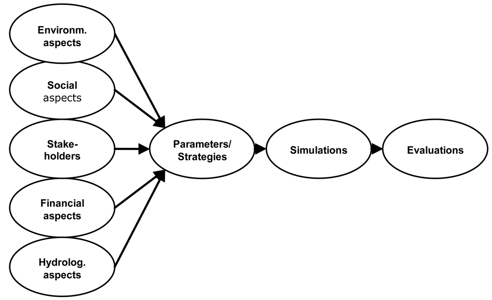
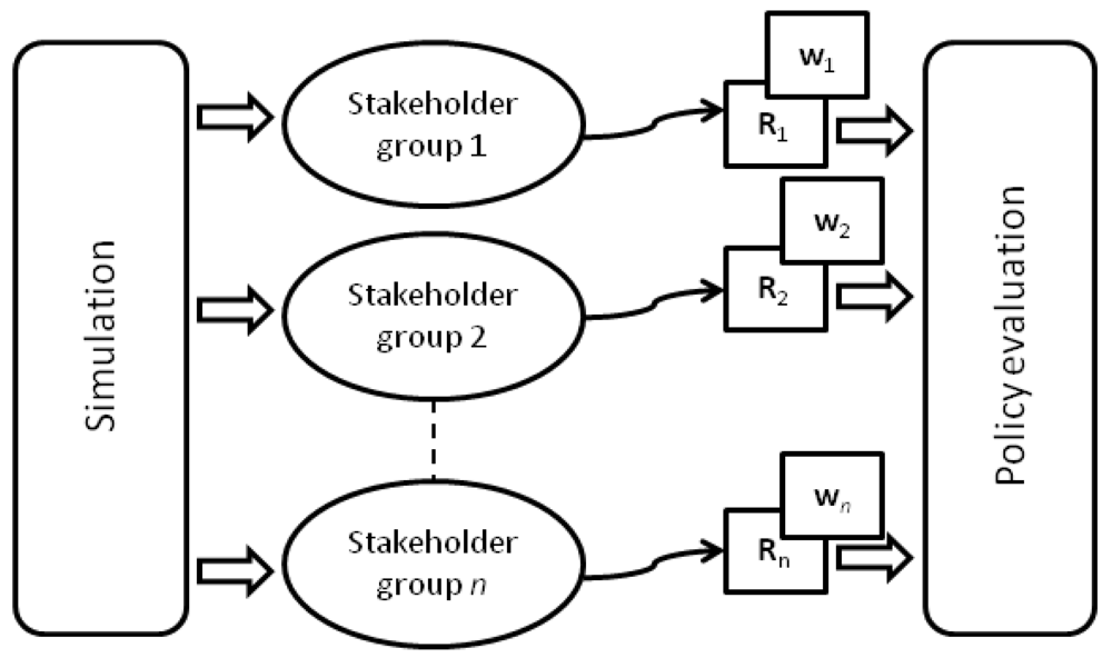
The development of the SEMPAI framework (Simulation and Evaluation with Multiple Perspectives and Agents Integrated) focuses on how a flood management program should be structured such that it reduces the human and economic losses and allocates the residual financial burdens in an acceptable way. The framework consists of a simulation model, a decision evaluation tool and a set of parameters which formulates possible policy strategies, see Figure 1. The framework combines analysis of flood risk models with multi-criteria decision analysis where multiple stakeholders are present. Criteria are identified, for instance which environmental, financial and social aspects that needs to be addressed. Stakeholders involved in the decision making process and those affected of the decision are also identified and data regarding stakeholders and criteria are implemented in the model. This is also vital for providing insights into the effects of imposing different policy options for a flood risk management programs. Using this setup, decision-makers and analysts can explore a set of policy packages taking all relevant information into account, including the perspectives and values of the stakeholders. After all data are identified and variables are set for each strategy, simulations are initialized using probabilities from earlier floods in the area. The result is automatically transferred into a decision analytical tool for evaluation of the results of the different policy strategies, see Figure 1.
Special attention has been paid to the presentation format. In practice, decision support systems and especially those who rely on analytics and formal models are often perceived as too complicated for ordinary decision-makers and general stakeholders. The framework is therefore augmented with automatic conversion of simulation results into formal decision models (essentially decision trees) for use in the decision evaluations. This integration provides the decision-makers and stakeholders with a domain specific tool in the assessment of consequences and for understanding various stakeholders' attitudes and needs, instead of an instance of a generic decision model only, thereby maintaining focus on the domain of flood management.
The framework was developed during two case studies, each evaluating different flood management strategies. The first case study regards a river basin in Hungary, which floods from the river Tisza. In the study, the focus is on financial aspects and the use of insurance as a mitigation strategy. The second case study concerns the Bac Hung Hai Polder in the Red River Delta in Vietnam where a broader focus is applied, putting social/health aspects as well as environmental aspects more into focus, thus adopting both a multi- and interdisciplinary approach. Each study and all features from them are presented in Section 4. In short, the framework contains the following set of distinguishing features not found integrated in any other proposed framework:
Simulation and evaluation integrated into the same framework for iterative assessment of different policies.
A set of predefined parameters to start a policy simulation and evaluation session.
Ability to handle both micro and macro levels in the same model.
Ability to handle short and long time horizons in the same model.
Includes several perspectives (criteria), not only financial.
Includes several stakeholders' (agents') views and preferences.
The need for this set of features has been established during the design of the framework and motivations are found especially in [41-43]. The financial evaluation, combining stakeholders and geographically explicit data with adjustable policy strategies is a core contribution. Furthermore, the model must reflect different stakeholders' point of view. The analyses of the different policy strategies have been based on a model in which the levee failures are simulated. The generated results are thereafter automatically transformed to decision trees under three stakeholder perspectives. Thus, taking the simulation results into account, the scenarios have been analyzed with a decision tool for evaluating the various costs, criteria, and probabilities involved. It is herein demonstrated how an implementation of a combined simulation and decision model, based on statistical data and interviews, can provide insights into the effects of imposing different policy scenarios for a flood risk management program in the region. Moreover, the approach is to some extent validated using stakeholder interviews after analyzing the scenarios for refinement purposes. A main issue is that all local respondents think that people should be able to stay in high-risk areas, and there seemed to be more agreement on assumptions and goals than on means to achieve these goals. This motivated the entire scenario construction approach. The three strategies were: (1) a continuation of the policy strategy in Hungary, i.e., the government compensates the property loss to a large extent; (2) the use of more private insurance; and finally (3) the use of a mandatory fee to a catastrophe fund.
These experiments indicated that modeling efforts are essential when analyzing new policy options for mitigating and financing in risk of a hazard. In order to estimate and cope with losses, policy makers often make use of computational models when evaluating flood scenarios and other disasters. A model is suggested for evaluating catastrophic floods in Hungary for identifying and evaluating the necessary variables and dependencies. This is supposed to be used in future work on spreading losses for the Tisza region. The simulations illustrate the importance of geographical data regarding catastrophe coverage due to the dependencies between damages in various locations. The experimental results demonstrate the possibility to incorporate efficiency and equity into the model by running the described scenarios and also to find relevant variables. The results also indicate the possibility of testing different approaches for the design of new policies in the Tisza area.
Furthermore, it was demonstrated that issues of solidarity are much more emphasized than market-based elements. This was the underlying motivation for selecting plausible criteria for the analyses, such as the environmental criteria. The results have been thoroughly discussed during a stakeholder workshop with a broad representation. Brouwers et al. [44] gives a total picture with the decision analytical tool incorporated into the framework. Brouwers and Hansson [41] describe the results from the simulations and it also describes all input into the simulation model in detail per group of stake-holders.
There is a micro/macro dimension in flood modeling. An average measurement is not really fully descriptive of individual losses. In our work, individual losses are included in the flood management strategy model. A step towards this approach has been taken in Brouwers and Hansson [45] as well as in Brouwers et al. [46]. Furthermore, decision-making capabilities for the individual property-owners have been implemented. The agents act on the micro level and the outcome is reflected on the macro level in the model. It must be emphasized that this is not an agent simulation model. It is rather an attempt to illustrate the dependencies in the model between the different levels. Our simulations of the flood management problem of the Upper Tisza basin demonstrated the need for catastrophe models with the ability to represent agents at different levels of granularity and with the possibility to include social patterns. A first step in this direction is achieved by letting the overall outcome be affected by the decisions of the individuals. The individual decision-maker is, in turn, affected by other actors, forming a social network of decision-makers.
3.2. Formal Modeling and MCDA
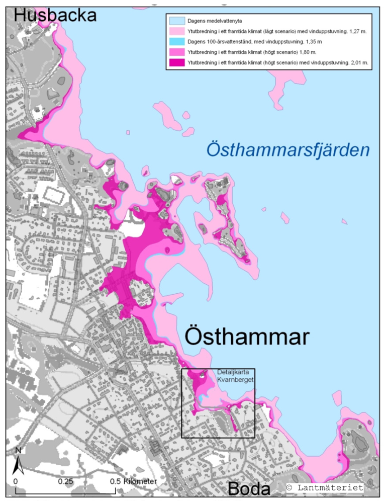
One important issue which needs to be addressed within the area of flood management is how the information is presented and explained to the decision-makers. Often, the result is produced as a static hazard map which shows the most vulnerable areas [47]. Information obtained from these geological hazard maps therefore does not always provide sufficient data to match the decision-makers' requirements. The information in general includes the normal flood level, and some probable situations for high water level. It is therefore important that the decision maker is fully informed on further possible outcomes, as well as interdisciplinary effects etc in order to see a broader perspective.
In Figure 2, we see a hazard map with four different states of possible extreme outcomes, with respect to probabilities of higher water level as well as wind speed and profile of land as well as land elevation. It is difficult to add more information into such maps. Then they may become confusing instead of providing more information [49]. Moreover, it is not possible to discuss or find out more on the relationships between different parameters or to perform any qualitative analysis using these maps. Bandibas et al. [49] present an interactive map for the purpose of decision support for stakeholders.
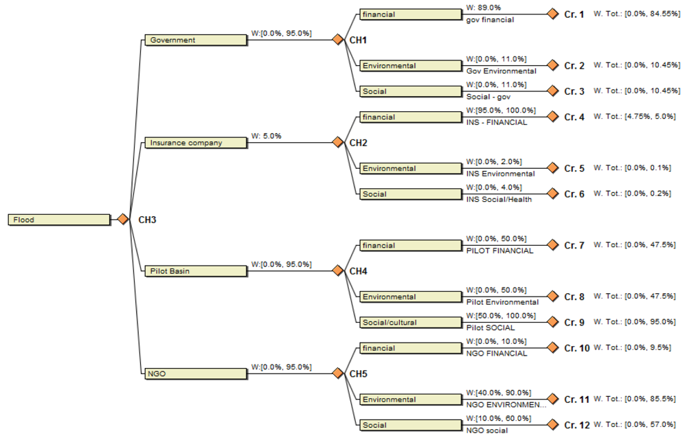
This particular model is, however, developed for volcanoes and not for flood plains. Yalcin and Akyürek [50] present a cell-based evaluation method using flood hazard maps from ArcView to present flood vulnerability maps. Additionally, they present a function for adding preferences for stake-holders using a weighting function for the different aspects. The main purpose of this method is to examine how sensitive the result is to changes by using fixed numbers. The SEMPAI framework uses a similar approach in the decision module, but where decision trees, usually used for the modeling of risky decisions, are employed instead of hazard maps. In the decision tree model used, a flood scenario in combination with a policy strategy is represented by a set of mutually exclusive but uncertain consequences associated with an interval-valued utility representing the value of that consequence for a given stakeholder group. Further, the decision trees are combined under several criteria in a criteria hierarchy model conforming to multi-criteria decision analysis (MCDA). By this approach, weights can be added to criteria as well as ranking each consequence if desired. In Figure 3, a criteria tree is shown. There are four stakeholder groups represented, each having ranked the different criteria using weights. Moreover, the groups of stakeholders can also be ranked.
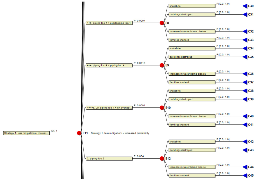
Critics point out, concerning MCDA, that evaluations are often reduced to some financial value [51]. However, the tool in the framework does not require fixed numbers, but allows instead assignment of a ranking order to the criteria and a preference order to the consequences instead of fixed weights and financial values respectively. Thus, an important component in our framework is the ability to handle imprecise and incomplete information, cf. [52]. The method includes functions for expressing and analyzing probabilities and values and is based on [53-58]. Using this approach, the classical risk and decision evaluation process can be extended by the integration of procedures for handling qualitative and numerically imprecise probabilities and utilities. In Figure 4, a fraction of a decision tree is presented. It shows a consequence tree where a strategy using less structural mitigation measures has been simulated. The decision trees are automatically created from the simulation results by means of a conversion algorithm, providing an overview of the result in an understandable fashion. In the figure you can see the different consequences, at different locations with different probabilities. This tree can then be evaluated together with the criteria tree. This entails a more formal but yet flexible representation of a modeling situation using a decision tree.
3.3. Incorporation and Modeling of Multiple Stakeholders
Adding a multi-criteria perspective to a framework for analyzing flood management strategies in an ex-ante manner has been beneficial in the sense that stakeholders can view the problem and perform impact assessments from different points of view. Consequences not financially measurable are also caused by floods, for instance loss of life or of a cultural important construction, or that an environmentally sensitive area is destroyed. It has proven to be successful to incorporate multiple criteria and combine them with the financial aspect for flood management decision situations.
Including stakeholders in the decision making process is also important in order to obtain a legitimate and socially sustainable solution to risk management. Thus, including stakeholder from all levels in a process provides a more sustainable outcome. However, designing a public involvement scheme in complex decision making with risk involved is difficult and it involves a number of non-trivial activities, some of which are discussed below.
Firstly, sharing data to all involved stakeholders is a necessity in order to understand the situation and what is at risk from various perspectives. This activity is typically more of an obstacle in developing countries since governmental agencies such as meteorological institutes may be under developed together with an unwillingness to reveal data to the public. In order to meet these difficulties presentations on retrieved data and workshops should be given continuously to involved stakeholders. Even an “open house” session would be beneficial for the community, providing the inhabitants with a session of informal discussion.
Second, a process for the elicitation of stakeholder preferences is needed. An objective would be to elicit utility functions for each group of stakeholders regarding each specific cooping strategy and/or set of pre specified criteria. Using this process, in our model, stakeholders state their preferences and give the different outcomes a ranking order if they are unsure of their preferred choice. The result is a preference assessment for each stakeholder. This activity together with the previous activity serve as the participatory element of the SEMPAI framework, actively involving the stakeholders in the policy making process.
Third, a method allowing for prioritization between stakeholder groups is vital. In the decision tool, stakeholders are given the opportunity to present the result of each group of stakeholders separately, or given a specific ranking order, or given a pareto optimal solution. This is vital in order to see the entire situation of a decision, and this opportunity provides an insight for stakeholders on other stake-holders' opinions. If ranking is difficult for a fair decision, it is instead possible to add weights on each stakeholder which can be set at a specific value or in an interval.
Fourth, a method allowing for prioritization between criteria needs to be performed. Thus, in specific decision situations and depending on the values and concern of a particular stakeholder, different criteria may be of different importance. For instance in an urban area, perhaps the social criteria and loss of life may be more important than the environmental criteria. Same method as above using weights and ranking are here used.
Fifth, presenting the result and giving the stakeholders the opportunity to elaborate with the result in order to understand the outcome better. Using the decision analytical tool, the decision maker can be presented with the result in different manners such as trees or influence diagrams.
In Figure 5, the flow and computation in SEMPAI is presented. Simulations are performed using all preset parameters, interdisciplinary relations, different strategies and uncertainties represented. The result is then transferred to the decision tool, where weights of each stakeholder group as well as each stakeholder group's ranking are assessed. Given this information set as a decision basis, SEMPAI evaluates and presents the result.
4. Case Studies
The framework was initially developed by evaluating a flood risk management policy decision problem in the Upper Tisza Basin in Hungary. The Tisza case was suitable for initial framework development since the Tisza region showed several characteristics of a region which urgently needed to adopt a new coping strategy. These characteristics were similar to many other regions in Eastern Europe. Such characteristics are, for instance, a poor region, mainly agricultural land, and dirt levees along the investigated section of the river. Thus, the evaluations of this area could be generalized to other regions. Moreover, as data was readily available because of an ongoing project in the region, it was the best candidate area available for evaluation; cf. [59,60].
The focus of the Tisza case study was on the use of financial mitigation measures, mainly insurance. During research for the case and from stakeholder workshops, it was discovered that the set of parameters ought to be extended in order to be able to better handle specific requirements of a developing country [61,62]. Naturally in a developing country, inhabitants in poor regions do often not have the means to purchase insurance. For instance, it is assumed to be financially beneficial for a poor region to be provided with aid as a risk reduction measure instead of post-disaster relief [63]. That is, as a pre-mitigation strategy in order to reduce the impact of a hazard and reduce risk, see [64]. Furthermore, a multi-criteria approach would greatly enhance the model [42]. Therefore, a refined and extended model was used in a second case study. The focus was now on the Bac Hung Hai Polder in the Red River Delta in northern Vietnam. This area was selected as it showed all the characteristics of a region in distress, with increasing population in vulnerable areas and a low land location. Moreover, contacts on location and via Delft University made data collection possible. Each case will now be discussed in more detail.
4.1. The Tisza Case Study
There are a vast number of catastrophe simulation models available, see, e.g., Aon, [65] and Clough [66], but in most cases, they do not combine data from several disciplines. Nor do they have the possibility to take individual stakeholders into consideration and at the same time investigate policy strategies. A primary purpose of this case was to combine a simulation and decision analysis model for large-scale policy decision making, exemplified by the effects of adopting different insurance schemes in combination with various levels of governmental compensation. The formulation of the schemes is based on stakeholder interviews performed in the Palad-Csecsei basin [60,67]. The stakeholders relevant for the flood-risk management problem are represented in the model as agents; the government, the insurers, and the property owners. Other agents could have been chosen, but the aforementioned were considered the most important ones when investigating potential financial flood risk management strategies.
For the Tisza case, an executable prototype simulation model was implemented, initially using synthetic data. Experiments on the prototype model indicated what features to improve or leave out in the simulation model. The prototype was based on an existing cyclone model developed by Ermolieva [68-70]. The prototype model was iteratively rebuilt to become a flood model. Experiments were performed on the prototype, the results of which made up the basis for the sharp version of the model using real data, see [71,72].
Stakeholders that were important for the flood management policy problem were identified, and parameters and strategies for coping with floods, to be used in the model, were elicited and validated during a sequence of interviews [59,60,67]. All levels of the society involved are included, from central to local governments as well as NGOs and insurance industry, cf. [41,44,46,71,72]. Moreover, constraints and boundaries for the model are stated in [73].
The simulation model was developed in an iterative fashion, constantly testing and improving the model. Monte Carlo simulation techniques were used for simulation of the flood failures, which were simulated 10,000 times from 10-year periods up to 50-year periods. In this way, a sufficient sample base to provide reliable statistical output was obtained [74]. Data from a specific hydrological model developed in Hungary was used [75]. Thus, cross-referenced data on, for instance, inhabitants and property owners in the region was used [76]. An exploratory modeling approach was applied and the policy strategies were set initially before each simulation. Thus, they were specified by the decision-maker beforehand in a participatory manner. The detailed setup for the simulations in the Hungarian study is described in [44,71,72,77].
For each iteration, sensitivity analyses using different constant values for different parameters were applied, such as for the uncertain variable magnitude (strength of flood), but also for other variables such as level of compensation from the government to a property owner having experienced a flood, cf. [71,77]. Then the results from the different simulations were compared against each other for abnormal or deviant results. Furthermore, this validation technique also provided the modellers with a view of how the system behavior changed. If deviant results appeared, the model was further investigated and modified accordingly. Then the procedure was repeated iteratively. In the presentation of the model results, several parameters, procedures, and functions within the simulation have, each time the investigated objects were used within the simulation, been shown on a screen. This is an animation technique, cf., e.g., [78]. It was performed in order to be able to follow the changes within the system for the specific object investigated, in order to verify that the correct process actually occurs within the program.
Moreover, the model and its results were, during the first development phase, presented to and discussed by participants several times within the Tisza project. This style of spiral development technique acted as a feedback loop applied to the model-test-evaluate development cycle employed. This was performed to ensure that the model produced the results required for the outcome of the project. Moreover during these meetings, the model served as a platform for discussions.
Stakeholders were involved early in the process. A stakeholder workshop was held where the Tisza version of the model was used, modified, discussed, and accepted [60,79]. The strategies used were also discussed at this workshop, i.e., a participatory approach was adopted [44]. By providing the stakeholders with a possibility to interact, elaborate, and compare results and the settings, the stakeholders gain an enhanced awareness of the decision. Transparency of the policy options, the decision itself as well as the settings in the model provided a positive effect in that conflicting opinions of stakeholders could after elaboration agree on an acceptable strategy.
Since all legitimate parties of a decision need to be aware of the content of the strategies, this was vital. If stakeholders are not aware of the different aspects of the strategies, it will be difficult for them to assess the decision situation [80]. Additionally, the stakeholders were given an opportunity to view the results from different perspectives as well as performing sensitivity analyses.
4.2. The Red River Case Study
A refined and extended model was applied to a second case study. The focus was now on the Bac Hung Hai Polder in the Red River Delta in northern Vietnam. This area was selected as it showed all the characteristics of a region in distress, with increasing population in vulnerable areas and a low land location. Moreover, contacts on location and via Delft University made data collection possible. The first step was here to perform a pilot study where fictive data on a larger area was used, requiring extending of the model [61]. During a field trip to the area, information and data was gathered and contacts with other researchers within the area of flood management were initiated. For the main study, where actual data was used, the flood probability distributions were retrieved on location and from [81-84]. The data was retrieved from several sources and triangulated for increased reliability. The detailed setup for the simulations in the study is found in [42,85].
In Hansson and Ekenberg [61] and Hansson [62], aspects of developing countries are discussed. Based on these pre-studies as well as on the policy strategies in the Tisza case, data was extracted from the strategies and a model for loss spreading in developing and emerging economies was proposed. Thus, the aim here was to extend the framework to become functional also for developing countries. In general, these countries have a higher degree of vulnerability. Important parameters are identified and discussed in relation to flood strategy formulations.
Countries in developing regions are now shifting focus from the use of structural mitigations and concentrating on reducing casualties towards a more sustainable long term solution. This is however difficult due to these countries vulnerable economies [86]. Hence, there is a need for a new straightforward framework able to handle evaluation of coping strategies in order to cope with the financial burden from hazardous events. Moreover, a river stretches over borders and countries should be able to use the framework as a focal point in discussions on water management. Thus, the simulation model was extended for facilitating a cross-border perspective. Also, loans and donations are vital for a developing country and a flood coping strategy often includes lending institutions.
As the framework models down to the individual level, handling situational diversity is vital since the behavior of each individual is unique. Achieving a sustainable solution, modelers need to understand the behavior of the inhabitants in a region. Furthermore, striving for a consensus goal implies that involved and affected stakeholders should agree on the program of flood protection and management [87].
As policy makers and decision analysts could benefit by a standardized method for evaluation of different loss spreading policies with the possibility to include multi stakeholder solutions, the suggested parameter set can easily be included in a simulation and decision model for policy formulation and evaluation, taking multiple stakeholders into account. We have found that in developing countries, compared to more developed, a broader perspective on policy issues for flood management is required. Based on this, several parameters have been introduced to the Sempai framework. Crop and livestock are some examples of such parameters that are important for many households in poorer regions. Hence, these parameters are incorporated in the framework, and if individual stakeholders suffer loss of crops or livestock, they are compensated for by the government and/or insurers. The results can be viewed from both a micro and a macro perspective, as in the Tisza case study.
Further, in introducing education to inhabitants in a region at risk, an opportunity is provided to take precautions on their own, such as flood proofing of houses or learning safe escape routes. Education and warning systems are therefore introduced as mitigation measures. Thresholds can be introduced for all mitigation measures. Thus, if enough funds are provided, damages and/or probabilities can be reduced. Elaborating these thresholds provides stakeholders with an opinion regarding the benefits of pre-mitigations.
For developing country issues, an international perspective is important. International aid and borrowing from international lenders are common approaches by developing countries to coping with losses from hazards. International aid is an important aspect since the world economy at large can more easily absorb losses compared to the GDP of nations affected [88,89]. Moreover, a wider perspective is also required in water management. It should not be restricted to a single country, instead involving countries working together over the borders regarding shared water, which makes it possible to reach a more sustainable future. The Red River case is presented in numerical detail in Hansson et al. [85]. It was implemented using a simulation model linked to evaluations using a decision analytical tool. Collected data from the Bac Hung Hai polder was used in the study. The results from the investigation demonstrate that, for this area, the use of more non-structural pre-mitigation measures, such as education and warning measures, was preferable for both property owners and the government, which lead to the conclusion that in some cases non-structural pre-mitigation measures are in fact financially preferable to structural measures. In more general terms, the case study demonstrates that it is feasible to use a combined simulation and evaluation framework for the investigation of flood management policies.
The environmental and the social criteria for Bac Hung Hai Polder included three and four different types of consequences respectively: drinking water polluted, mangrove destroyed, river poisoned for the environment and families shattered, increase in water borne disease, historical/religions buildings destroyed and snakebite for the social criterion. These are “soft” criteria (difficult to value) and using them in order to reach a “hard” result is not easy, but by assigning each criterion a preference order this can be achieved. For each unique event and for each location, each group of stakeholder can rank criteria and assign a value (or an interval) if desired. The importance of each consequence is discussed and motivated in Hansson et al. [42]. These suggested consequences are common in developing countries. However, they are not cast in concrete and additional or other consequences could be added to the framework depending on location. Needless to say, the granularity of the model adjusts to the actual circumstances in the country or region in concern. Criteria trees are created in the decision tool and evaluated. In the previous studies the policy making problems are evaluated using weights over stakeholders as well as over strategies. Within this study, criteria which also have importance weights and could be ranked between stakeholders are added. Therefore, each stakeholder can assign weights and/or preference orders stating which criteria are the most important. Consequently, one more dimension is added to the flood management policy decision modeling.
4.3. The Svartån Case Study
A third case study was carried out in the Swedish municipality of Örebro focusing on measures needed in order secure the future water quality of the small river Svartån, see Danielson et al. [90] for a comprehensive presentation of this case. The river in focus had for centuries been manipulated by farmers and industries as well as by the continuous urban activities of the Örebro region. The river is a crucial asset to the city and its surroundings as it is the main water source for a multitude of purposes such as drinking water access, agriculture, and recreational swimming. For several years there have been unacceptably high amounts of intestinal bacteria in the water, originating from human and different types of animal feces. The measures taken so far have not shown any apparent improvements, and there is a need for more investigations in order to make more precise judgments regarding the significance of the different sources of contamination, e.g., livestock manure entering the water, individual households with malfunctioning closet sewers, insufficient drainage systems for peak flows, sewer overflow, and urban water. There is a high bacteria count already before the river passes the city of Örebro, which implies that sources upstream of the city must be handled before any measures taken within the city itself can be expected to have a decisive effect.
Further, there are several stakeholders who could be affected differently, and there are different views on the need for and effect of different measures. Therefore, the decision-makers expressed a strong desire to obtain a sustainable and approved solution, even though they have different political standpoints, and the decision to make is multifaceted in nature. The ultimate objective of the process was to obtain a sustainable long-term solution with increased water quality in general, in line with the EU water directive.
The case was carried out in a series of eight modeling workshops involving both decision makers and environmental engineers, starting with identifying the “soft” criteria for the decision problem and ending with criteria weight elicitation and joint discussion sessions. For the criteria weight elicitation a new graphical assessment method was developed and tested [91]. This case did not involve any explicit weighting of the stakeholders due to political considerations (the decision makers were all local politicians in the urban planning board). The civil servants identified a set of “hard” criteria for each fundamental criterion and these were later confirmed by the politicians in a joint workshop. Thereafter, they compiled all their information regarding different possible measures and their corresponding effects and identified a set of loosely defined but distinguishable alternatives. The approach facilitated the work of identifying alternatives from the large set of possible measures (about forty) suggested by three major environment consultancy firms. These were specified further in a collaborative fashion in reference to seven possible alternatives which were placed in a priority ranking according to what extent they are judged to achieve the overall objective of persistent water quality in the river. Notably, some of these alternatives were clearly policy related, such as more extensive regulations with respect to farmer's treatment of manure. One main outcome of the case was that the alternative focusing on the building of wetlands allowing for drainage water from the surrounding fields to pass through it were to be prioritized, whereas the large investment in a biogas installation with a digestion chamber for bacteria elimination were of a low importance with respect to the objective of increasing the water quality of the river.
5. Concluding Remarks
This paper suggests a framework for flood management policy formation. A set of generally desirable properties of such a framework is discussed, including a flood simulation model, a multi-criteria decision analysis tool, and a set of policy strategies for flood damage assessment applying an ex-ante approach. We argue that there is a need to emphasize the democracy perspective of societal risk management situations in order to reach more fair and stable solutions, and that a risk management framework is important when evaluating developmental factors, or evaluating the significance of a project in terms of efficiency, effectiveness, and sustainability. A combined model is advocated, i.e., both a flood model and a strategy evaluation model in order to provide aid in both gaining an overview of a situation and understanding the effects of a strategy choice.
The framework has been developed in an iterative process over a period of several years and knowledge from several disciplines has been incorporated. Both micro and macro aspects are included in the model, and the output may be customized to any desired degree of geographical resolution down to household location level. Moreover, the flood simulation model may as well be shifted towards a costal inundation model using similar parameters. Adjustments to the decision tool will be small and easy to perform, but we do stress the importance of utilizing a well-evaluated costal inundation simulation tool.
During developing and pilot cases, the effects of introducing different flood management strategies in the Tisza Region in Hungary and in the Back Hung Hai polder in the Red River Delta in Vietnam have been investigated. In the latter case, the specific situation for developing countries when managing risk was of prime concern. This includes both citizens' increased knowledge on how to set up their own mitigation measures as well as the use of insurance systems making people less vulnerable to production failures and loss of income. Therefore parameters that enable calculations on loans and aid provided are included as well as more qualitative values, such as education and awareness of floods, escape routes, and hazard maps in combination with early warnings are essential long-term strategies, particularly important for developing countries.
The results presented have been beneficial as a basis for discussions on the pros and cons of different alternative policy strategies. This is of particular concern in settings where policy-makers and stake-holders work together.
To utilize the framework for hazard planning beyond flood management alone would be beneficial. Adding criteria and layers in a decision tool helps the decision maker to keep track of the extensive amount of data often produced in societal risk management contexts. Although, introducing more aspects into hazard planning increases the amount of uncertainty, which should be addressed in the evaluation process. An interesting issue is to consider relations between different types of hazards. For instance, if drainage of wet land areas is performed, this could have impact on agriculture, drought and flooding. Moreover, escape routes and warning systems of different types could be set up for several types of contingencies such as floods, hurricanes and wildfires. Obviously, several different modules regarding different types of hazards must be added and tested in order for this process to be considered. The model has particular potential in an open and deliberative process aimed at evaluating decision management policies on catastrophic losses. Consequently, decision-makers, lending institutions, donor agencies, and hazard prevention managers may benefit from the framework. Evaluations have been useful as a guidance tool and as aid in hazard management, to investigate and evaluate several possible solutions and the outcomes of the solutions. Using this framework may help governments and decision-makers to identify their own multiple hazard risks, as well as identify activities which can be implemented before the next flood event. The framework facilitates identification of risks, benefits, and drawbacks from these different activities, as well as the identification of the most important aspects to consider when implementing, for instance, a structural measure or insurance in a region at risk. Damage assessments for social, environmental, and financial aspects may further be incorporated. Importantly, unfair actions may be identified from both micro and macro perspectives. Furthermore, the framework holds information on measurable variables which can be used in the evaluation of a flood coping strategy.


| Type of model | Flood behavior model | Flood hazard estimation model | Flood loss estimation model | Mitigation model |
|---|---|---|---|---|
| Focus | Understanding how floods occur, predictions, frequencies | Vulnerability assessment, likelihood assessment, flood characterization | Assessing losses given a location | Assessing costs/benefits from mitigation strategies |
References and Notes
- Associated Programme on Flood Management (APFM). Strategy for Flood Management, for Lake Victoria Basin, Kenya; World Metrological organization (WMO): Geneva, Switzerland, 2004. Available online: http://www.apfm.info/pdf/strategy_kenya_e.pdf (accessed on 21 August 2011).
- IPCC. Climate Change: The Scientific Basis. Contribution of Working Group I to the Third Assessment Report of the Intergovernmental Panel on Climate Change; Houghton, J.T., Ding, Y., Griggs, D.J., Noguer, M., van der Linden, P.J., Dai, X., Maskell, K., Johnson, C.A., Eds.; Cambridge University Press: Cambridge, UK, 2001. [Google Scholar]
- Hansen, E.J.; Sato, M.; Ruedy, R.; Lo, K.; Lea, D.; Medina-Elizade, M. Global temperature change. Proc. Natl. Acad. Sci. USA 2006, 103, 14288–14293. [Google Scholar]
- Hansen, E.J.; Sato, M. Paleoclimate implications for human-made climate change. Climate Change at the Eve of the Second Decade of the Century: Inferences from Paleoclimate and Regional Aspects; Berger, A., Mesinger, F., Šijači, D., Eds.; Springer: Heidelberg, Germany, 2011. (in press); Available online: http://pubs.giss.nasa.gov/abs/ha05510d.html (accessed on 25 August 2011). [Google Scholar]
- Tol, R.; van der Grijp, N.; Olsthoorn, X.; van der Werff, P. Flood Risk Mitigation and Institutional Response. Presented at the IIASA Conference on Global Change and Catastrophe Risk Management: Flood Risks in Europe, Laxenburg, Austria, 6-9 June, 1999.
- World Disaster Report; Chapter 8, Disaster Data: Key Trends and Statistics; International Federation of Red Cross and Red Crescent Societies: Geneva, Switzerland, 2001.
- Disaster Management in Southeast Asia, an Overview; Bildan, L., Ed.; Asian Disaster Preparedness Centre (ADPC): Klong Luan, Thailand, 2003.
- UN Commission on Sustainable Development. Decision on Integrated Planning and Management of Land Resources Adopted by the Eighth Session of the CSD, New York, NY, USA, 24 April–5 May 2000.
- Zhu, X. Floods in Bangladesh: The way forward. World Bank Group: Washington DC, USA, 2007. Available online: http://go.worldbank.org/LUKLZXFLP0 (accessed on 7 February 2011). [Google Scholar]
- Kovats, S.; Akhtar, R. Climate, climate change and human health in Asian cities. Environ. Urban. 2008, 20, 165–175. [Google Scholar]
- Bangladesh. 2004 Flood, Response, Damage and Recovery Needs, 2004 (As of 30 September 2004). Asian Development Bank (ADB): Manila, Philippines, 2004. Available online: http://www.adb.org/Documents/Economic_Updates/BAN/2004/eco-update-ban.pdf (accessed on 9 February 2011).
- Mozambique Prepares for another Flood Season; Beira, S.O., Ed.; International Federation of Red Cross and Red Crescent Societies: Geneva, Switzerland, 2002.
- Defra Environment Agency. Flood and Coastal Defence R&D Programme, Reducing Uncertainty in River Flood Conveyance, Phase 2. Project Record W5A-057/PR/1; Environment Agency: Bristol, UK, 2004. [Google Scholar]
- Renn, O. The Challenge of Integrating Deliberation and Expertise: Participation and Discourse in Risk Management. In Risk Analysis and Society; McDaniels, T., Small, M., Eds.; Cambridge University Press: Cambridge, UK, 2003. [Google Scholar]
- Riebsame, E.W. Climate Hazards Climate Change, and Development Planning. In Managing Natural Disasters and the Environment; Kreimer, A., Munasinghe, M., Eds.; World Bank, Environmental and Policy and Research Division Environment Department: Washington, DC, USA, 1990; pp. 9–16. [Google Scholar]
- Schulze, K.; Hunger, M.; Döll, P. Simulating river flow velocity on global scale. Adv. Geosci. 2005, 5, 133–136. [Google Scholar]
- Wagner, C.R.; Mueller, D.S. Use of Velocity Data to Calibrate and Validate Two-Dimensional Hydrodynamic Models. Proceedings of the Second Federal Interagency Hydrologic Modeling Conference, Las Vegas, NV, USA, 29 July–1 August 2002.
- Yue, W.; Lin, C.-L.; Patel, V.C. Large-eddy simulation of turbulent flow over a fixed two-dimensional dune. J. Hydrol. Eng. 2006, 132, 643–651. [Google Scholar]
- Talbot, C.A.; Hansen, C.M.; Jones, N.L.; Edris, E.V. GMS 4.0: New Modeling Tools For Stratigraphic and Stochastic Modeling and Uncertainty Analysis, Watershed Systems Conference, Portland, Oregon, USA, 13–15 May 2003.
- Dutta, D.; Herath, S. GIS Based Flood Loss Estimation Modeling in Japan. Proceedings of the US-Japan 1st Workshop on Comparative Study on Urban Disaster Management, Port Island, Kobe, Japan; 2001; pp. 151–161. [Google Scholar]
- Bates, P.D.; de Roo, A.P.J. A simple raster-based model for flood inundation simulation. J. Hydrol. 2000, 236, 54–77. [Google Scholar]
- Pham, V.-H. Use of Remote Sensing GIS Technology for Monitoring and Assessment of Flooding Status at the Coastal Zone in the Central Part of Vietnam. Proceedings of the 3rd FIG regional Conference—Surveying the Future, Contributions to Economic, Environmental and Social Development, Jakarta, Indonesia, 3–7 October 2004.
- Daykin, C.D.; Pentikainen, T.; Pesonen, M. Practical Risk Theory for Actuaries. Monographs on Statistics and Applied Probability; Chapman and Hall Ltd: London, UK, 1994; Volume 53. [Google Scholar]
- Buhlmann, H. Mathematical Methods in Risk Theory; Springer-Verlag: New York, NY, USA, 1970. [Google Scholar]
- Muir-Wood, R. Employing Catastrophe Loss Modelling to Price and Manage European Flood Risk. Proceedings of the EuroConference on Global Change and Catastrophe Risk Management: Flood Risks in Europe, IIASA, Laxenburg, Austria, 6–9 June 1999.
- NIBS and FEMA. Multi Hazard Loss Estimation Methodology, Flood Model, HAZUS-MH Technical Manual; National Institute of Building Sciences and Federal Emergency Management Agency: Washington, DC, USA, 2003. [Google Scholar]
- Khatabi, R.; Haywood, J. The role of flood forecasting and warning in sustainability of flood defense. Proc. Inst. Civ. Eng. 2002, 151, 313–320. [Google Scholar]
- Yu, P.-S.; Wang, Y.-C.; Yang, T.-C.; Kuo, C.-C. Optimum use of paddy fields for flood mitigation. J. Am. Water Resour. Assoc. 2006, 42, 375–386. [Google Scholar]
- The DIPECHO programme: Reducing the impact of disasters. ECHO European Commission Humanitarian Aid Department: Brussels, Belgium, 2004. Available online: http://www.eird.org/herramientas/eng/partners/echo/dipechoenglish.pdf (accessed on 21 August 2011).
- Faisal, M.; Kabir, M.R.; Nishat, A. The disastrous flood of 1998 and long term mitigation strategies for Dhaka City. J. Nat. Hazards 2003, 28, 85–99. [Google Scholar]
- Adapting to climate change in developing countries, Post note 269; Parliamentary office of science and technology (POST): London, UK, 2006.
- Fernando, A. The Role of Nongovernment Organizations in Sri Lanka, Managing Natural Disasters and the Environment; Kreimer, A., Munasinghe, M., Eds.; World Bank: Washington, DC, USA, 1990. [Google Scholar]
- Ahmad, Q.K. Regional cooperation in flood management in the Ganges-Brahmaputra-Meghna Region: Bangladesh perspective. J. Nat. Hazards 2003, 28, 191–198. [Google Scholar]
- Bengtsson, Å; Sundström, B. Ett direktiv för god vattenstatus. In In report Bottniska Viken 2004; Umeå Marina Forskningscentrum: Umeå, Sweden, 2004; pp. 37–39, in Swedish. [Google Scholar]
- László, F. Lessons learned from the cyanide and the heavy metal accidental water pollution in the Tisa river basin in the year 2000. In Management of Intentional and Accidental Water Pollution; Dura, G., Ed.; Springer Media B.V.: Houten, Netherlands, 2006; pp. 43–45. [Google Scholar]
- Hall, J.W.; Meadowcroft, I.C.; Sayers, P.B.; Bramley, M.E. Integrated flood risk management in England and Wales. Nat. Hazards Rev. 2003, 4, 126–135. [Google Scholar]
- Ahmed, M. Development and Management Challenges of Integrated Planning for Sustainable Productivity of Water Resources. Proceedings of Biennial Conference of Bangladesh Economic Association, Dhaka, Bengal, September 2002.
- Vanberg, V.J. Rules and Choice in Economics; Routledge: London, UK, 1994. [Google Scholar]
- Mackey, W.F.; Baucknight, J. Systems Approaches and Their Applications—Examples from Sweden; Olsson, M.O., Sjöstedt, G., Eds.; Kluwer Academic: Dordrecht, the Netherlands, 2000; pp. 2–4. [Google Scholar]
- Whitten, J.; Bentley, L. Systems Analysis and Design Methods; McGraw-Hill/Irwin Primis Content Center, Primis Online: Columbus, OH, USA, 2005. [Google Scholar]
- Brouwers, L.; Hansson, K. Presentation of Simulations of Three Flood Management Strategies: The Palad-Csecsei Basin. In Appendix to the Report Simulation and Analysis of Three Flood Management Strategies; International Institute of Applied Systems Analysis (IIASA): Laxenburg, Austria, 2003. [Google Scholar]
- Hansson, K.; Danielson, M.; Ekenberg, L. Handling Multiple Criteria in Flood Management Decision Making. In Integrated Catastrophe Risk Modelling, Supporting Policy Processes; Amendola, A., Ermolivea, T., Linnerooth-Bayer, J., Mechler, R., Eds.; Springer: Berlin, Germany, 2011. [Google Scholar]
- Hansson, K.; Danielson, M.; Ekenberg, L. Assessment of a flood management framework. Int. J. Public Inf. Syst. 2008, 4, 25–37. [Google Scholar]
- Brouwers, L.; Danielson, M.; Ekenberg, L.; Hansson, K. Multi-criteria decision-making of policy strategies with public-private re-insurance systems. Risk Decis. Policy 2004, 9, 23–45. [Google Scholar]
- Brouwers, L.; Hansson, K. MicroWorlds as a Tool for Policy Making. Proceedings of the International Workshop on Cognitive Research with Microworlds—Methodological and Theoretical Issues for Industrial Applications, Granada, Spain, 12–14 November 2001.
- Brouwers, L.; Hansson, K.; Verhagen, H.; Boman, M. Agent Models of Catastrophic Events, Modelling Autonomous Agents in a Multi-Agent World. Prceedings of the 10th European Workshop on Multi-Agent Systems, Annecy, France, 2–4 May, 2001.
- NOAA Coastal Services Center. Risk and Vulnerability Assessment Tool (RVAT); National Coastal Data Development Center: Washington, DC, USA, 2007. [Google Scholar]
- Picture: Översvämningskartetering från Östhammar. Produced by Lantmäteriet, for SMHI. Diarienummer: 507-98-4774. SMHI: Norrköping, Sweden, 2011. Available online: http://www.smhi.se/polopoly_fs/1.9141!%C3%96versv%C3%A4mningskart.pdf (accessed on 27 March 2011).
- Bandibas, J.; Wakita, K.; Kato, H. Interactive presentation of geological hazard maps. J. Nat. Disaster Sci. 2003, 25, 75–83. [Google Scholar]
- Yalcin, G.; Akyürek, Z. Multiple Criteria Analysis for Flood Vulnerable Areas. Proceedings of the ESRI-2004 User Conference, San Diego, CA, USA, 9–13 August 2004.
- Phillips, L. Creating More Effective Research and Development Portfolios; London School of Economics and Political Science: London, UK, 2002. Available online: http://www.catalyze.co.uk/R&DPortfolios.pdf(accessed on 2 August 2006).
- Danielson, M.; Ekenberg, L.; Hansson, K.; Idefeldt, J.; Larsson, A.; Påhlman, M.; Riabacke, A.; Sundgren, D. Cross-Disciplinary Research in Analytic Decision Support Systems. Proceedings of the International Conference of Information Technology Interfaces, Dubrovnik, Croatia, 19–22 June 2006.
- Danielson, M. Handling imperfect user statements in real-life decision analysis. Int. J. Inf. Technol. Decis. Mak. 2004, 3, 513–534. [Google Scholar]
- Danielson, M. Generalized evaluation in decision analysis. Eur. J. Oper. Res. 2005, 162, 442–449. [Google Scholar]
- Ekenberg, L. Risk Constraints in Agent Based Decisions. In Encyclopaedia of Computer Science and Technology; Kent, A., Williams, J.G., Eds.; Marcel Dekker Inc.: New York, NY, USA, 2000; Volume 43, pp. 263–280. [Google Scholar]
- Danielson, M.; Ekenberg, L. A framework for analysing decisions under risk. Eur. J. Oper. Res. 1998, 104, 474–484. [Google Scholar]
- Danielson, M.; Ekenberg, L. Computing upper and lower bounds in interval decision trees. Eur. J. Oper. Res. 2007, 181, 808–816. [Google Scholar]
- Ekenberg, L.; Thorbiörnson, J.; Baidya, T. Value differences using second order distributions. Int. J. Approx. Reason. 2005, 38, 81–97. [Google Scholar]
- Vári, A. Public involvement in flood risk management in Hungary. J. Risk Res. 2000, 5, 211–224. [Google Scholar]
- Vári, A.; Linnerooth-Bayer, J.; Ferencz, Z. Stakeholder views on flood risk management in Hungary's Upper Tisza Basin. Risk Anal. 2003, 23, 585–600. [Google Scholar]
- Hansson, K.; Ekenberg, L. Flood Mitigation Strategies for the Red River Delta. Proceedings of the 2002 Joint CSCE/EWRI of ASCE International Conference on Environmental Engineering, An International Perspective on Environmental Engineering, Niagara Falls, Ontario, Canada, 21–24 July 2002.
- Hansson, K. The Importance of Pre Mitigation Strategies in Development Planning. Proceedings of the Forth International Conference on Risk Analysis, Computer Simulation in Risk Analysis and Hazard Mitigation, Rhodes, Greece, 27–29 September 2004.
- Anderson, M.B. Analyzing the Costs and Benefits of Natural Disaster Responses in the Context of Development; The World Bank, Environment Department: Washington DC, USA, 1990. [Google Scholar]
- Hansson, K.; Danielson, M.; Ekenberg, L. A framework for evaluation of flood management strategies. J. Environ. Manage. 2008, 86, 465–480. [Google Scholar]
- Capital Risk Management and Modelling; Aon Holdings: Rottterdam, Netherlands, 2002. Available online: http://www.aon.com.au (accessed on Day October 2002).
- Reinsurance Company. Catastrophe Modeling Group; Clough H., Inc.: Contoocook, Netherlands, 2002. Available online: http://www.clough.com/CLOUGH.nsf/Doc/Index (accessed on 22 June 2002).
- Vári, A. Stakeholder views on flood risk in the Upper Tisza Region. Tarsadalomkutatas 2001, 1-2, 65–78. [Google Scholar]
- Ermolieva, T. The Design of Optimal Insurance Decisions in the Presence of Catastrophic Risks; Interim Report IR-97-068; International Institute of Applied Systems Analysis (IIASA): Laxenburg, Austria, 1997. [Google Scholar]
- Ermolieva, T.; Ermoliev, Y.; Norkin, V. Spatial Stochastic Model for Optimisation Capacity of Insurance Networks under Dependent Catastrophic Risks: Numerical Experiments; Interim Report IR-97.028; International Institute of Applied Systems Analysis (IIASA): Laxenburg, Austria, 1997. [Google Scholar]
- Ermoliev, Y.M.; Ermolieva, T.Y.; MacDonald, G.J.; Norkin, V.I. On the Design of Catastrophic Risk Portfolios; Interim Report IR-98-056; International Institute of Applied Systems Analysis (IIASA): Laxenburg, Austria, 1998. [Google Scholar]
- Hansson, K. Managing Natural Catastrophe Loss. Simulation of Policy Strategies. Licentiate Thesis, Report No. 02-011. Department of Computer and Systems Sciences, Stockholm University/Royal Institute of Technology, Stockholm, Sweden, 2002. [Google Scholar]
- Brouwers, L.; Hansson, K.; Ekenberg, L. Presentation of Simulations of Three Competing Flood Management Strategies: A Case Study. Proceedings of the IASTED International Conference on Applied Simulation and Modelling (ASM 2002), Crete Greece, 25–28 June 2002.
- Linnerooth-Bayer, J.; Vári, A. A research proposal on Flood Risk Management Policy in the Upper Tisza Basin A System Analytical Approach, Submitted by the RMS Project; International Institute of Applied Systems Analysis (IIASA): Laxenburg, Austria, 1999. [Google Scholar]
- Miao, Z.; Trevisan, M.; Capri, E.; Padovani, L.; Del Re, A.A. Uncertainty assessment of the model RICEWQ in northern Italy. J. Environ. Qual. 2004, 33, 2217–2228. [Google Scholar]
- THRD. Explanation of Detailed Methodology for Flood Damage, Assessment. In Appendix 17-5 to THRD; World Bank Report: THRD: Grant No: TF-027107; Washington USA, 1999. [Google Scholar]
- Hungarian Central Statistical Office. Major Annual Figures-Regional; Központi Statisztikai Hivatal: Budapest, Hungary, 2000. Available online: http://portal.ksh.hu (accessed on 1 August 2000).
- Hansson, K. Modelling Policy Options for Flood Management, YSSP report; International Institute of Applied Systems Analysis (IIASA): Laxenburg, Austria, 2002. [Google Scholar]
- Luu, V-T. Simulating Centipede Locomotion. CS499 Research Report Oderobot, Centipede.bib. 1999. [Google Scholar]
- Ekenberg, L.; Brouwers, L.; Danielson, M.; Hansson, K.; Johansson, J.; Riabacke, A.; Vári, A. Flood Risk Management Policy in the Upper Tisza Basin: A System Analytical Approach—Simulation and Analysis of Three Flood Management Strategies, Interim Report IR-03-003; International Institute of Applied Systems Analysis (IIASA): Laxenburg, Austria, 2003. [Google Scholar]
- Feás, J.; Giupponi, C.; Rosato, P. Water Management, Public Participation and Decision Support Systems: the MULINO Approach. Proceedings of the Complexity and Integrated Resources Management, Manno, Switzerland, 4–17 June 2004.
- SWECO/WL. Flood Risk Assessment for Bac Hung Hai Polder; 2nd Red River Basin Sector Project, Report, Part A: Water Resources Management, Project Number 30292-03; Asian Development Bank (ADB): Viet Nam, 2005. [Google Scholar]
- SWECO/WL. Flood Risk Assessment for Bac Hung Hai Polder. In Annexes A-H. 2nd Red River Basin Sector Project, Report, part A: Water Resources Management, Project Number 30292-03; Asian Development Bank (ADB): Viet Nam, 2005. [Google Scholar]
- UN, National Roundtable Workshop to review the findings of application of the ECLAC methodology on assessment of socio-economic impacts of disasters in Viet Nam. Proceedings of The United Nations Economic and Social Commission for Asia and the Pacific (ESCAP), Hanoi, Vietnam, 23–24 May 2005.
- GSO, General Statistics Office of Vietnam. Statistics Documentation Centre: Ha noi, Vietnam, 2005. Available online: http://www.gso.gov.vn/ (accessed on day month 2005).
- Hansson, K.; Ekenberg, L.; Danielson, M. Implementation of a Decision Theoretical Framework: A Case Study of the Red River Delta in Vietnam. Proceedings of the 19th International Florida AI Research Society Conference, Melbourne Beach, FL, USA, 11–13 May 2006; pp. 824–829.
- Benson, C. Economic Impact of Natural Disasters in Vietnam; Overseas Development Inst.: London, UK, 1997. [Google Scholar]
- Abarquez, I.; Murshed, Z. Community-Based Disaster Risk Management, Field Practitioners' Handbook; Asian Disaster Preparedness Center (ADPC): Bangkok, Thailand, 2004. [Google Scholar]
- Linnerooth-Bayer, J.; Amendola, A. Global change, natural disasters and loss-sharing: Issues of efficiency and equity. Geneva Pap. Risk Insur. Issues Pract. 2000, 25, 203–219. [Google Scholar]
- Learning from Disaster: The Floods in the Czech Republic. Poland and Germany in the summer of 1997; Swiss Reinsurance Company: Zurich: Switzerland, 1997.
- Danielson, M.; Ekenberg, L.; Larsson, A.; Riabacke, M. Transparent Public Decision Making: Discussion and Case Study in Sweden. In e-Democracy—A Group Decision and Negotiation Perspective; French, S., Ríos Insua, D., Eds.; Springer: Berlin, Germany, 2010; pp. 263–281. [Google Scholar]
- Riabacke, M.; Danielson, M.; Ekenberg, L.; Larsson, A. A Prescriptive Approach for Eliciting Imprecise Weight Statements in an MCDA Process. Proceedings of 1st International Conference on Algorithmic Decision Theory (ADT), Venice, Italy, 21–23 October 2009.
© 2011 by the authors; licensee MDPI, Basel, Switzerland. This article is an open access article distributed under the terms and conditions of the Creative Commons Attribution license (http://creativecommons.org/licenses/by/3.0/).
Share and Cite
Hansson, K.; Larsson, A.; Danielson, M.; Ekenberg, L. Coping with Complex Environmental and Societal Flood Risk Management Decisions: An Integrated Multi-criteria Framework. Sustainability 2011, 3, 1357-1380. https://doi.org/10.3390/su3091357
Hansson K, Larsson A, Danielson M, Ekenberg L. Coping with Complex Environmental and Societal Flood Risk Management Decisions: An Integrated Multi-criteria Framework. Sustainability. 2011; 3(9):1357-1380. https://doi.org/10.3390/su3091357
Chicago/Turabian StyleHansson, Karin, Aron Larsson, Mats Danielson, and Love Ekenberg. 2011. "Coping with Complex Environmental and Societal Flood Risk Management Decisions: An Integrated Multi-criteria Framework" Sustainability 3, no. 9: 1357-1380. https://doi.org/10.3390/su3091357