Modeling Sustainability of Water, Environment, Livelihood, and Culture in Traditional Irrigation Communities and Their Linked Watersheds

Abstract
:1. Introduction
1.1. Threats to Sustainability of Acequia Systems
1.2. Acequia Communities as Coupled Natural and Human Systems
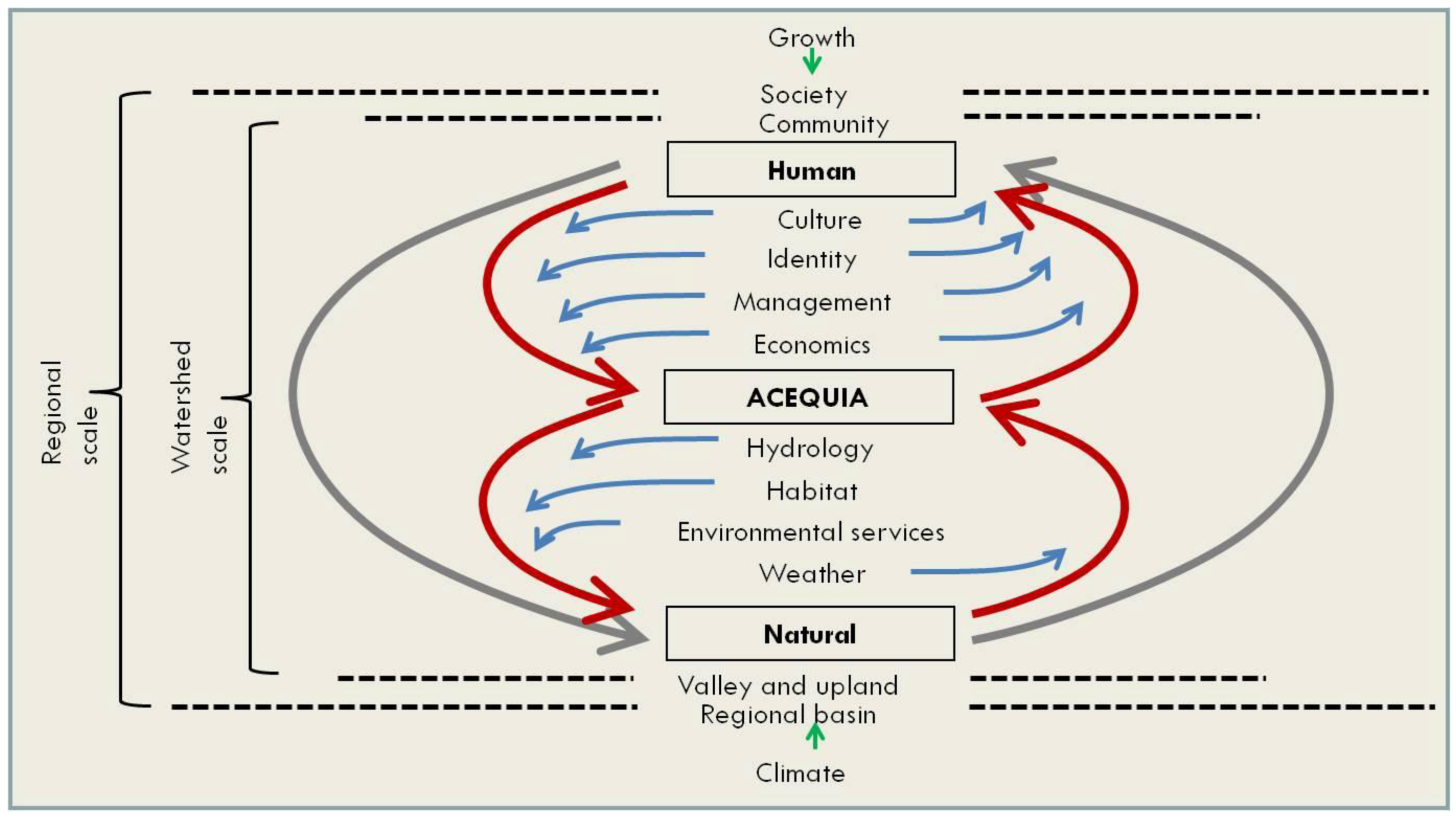
1.3. High Level Overview of Coupled Systems

1.4. Sociocultural Linkages within and between Communities
1.5. Hydrologic Connections between Acequia Irrigation Systems, Aquifers, and Rivers
1.6. Socioeconomic Responses to Changing Water Availability
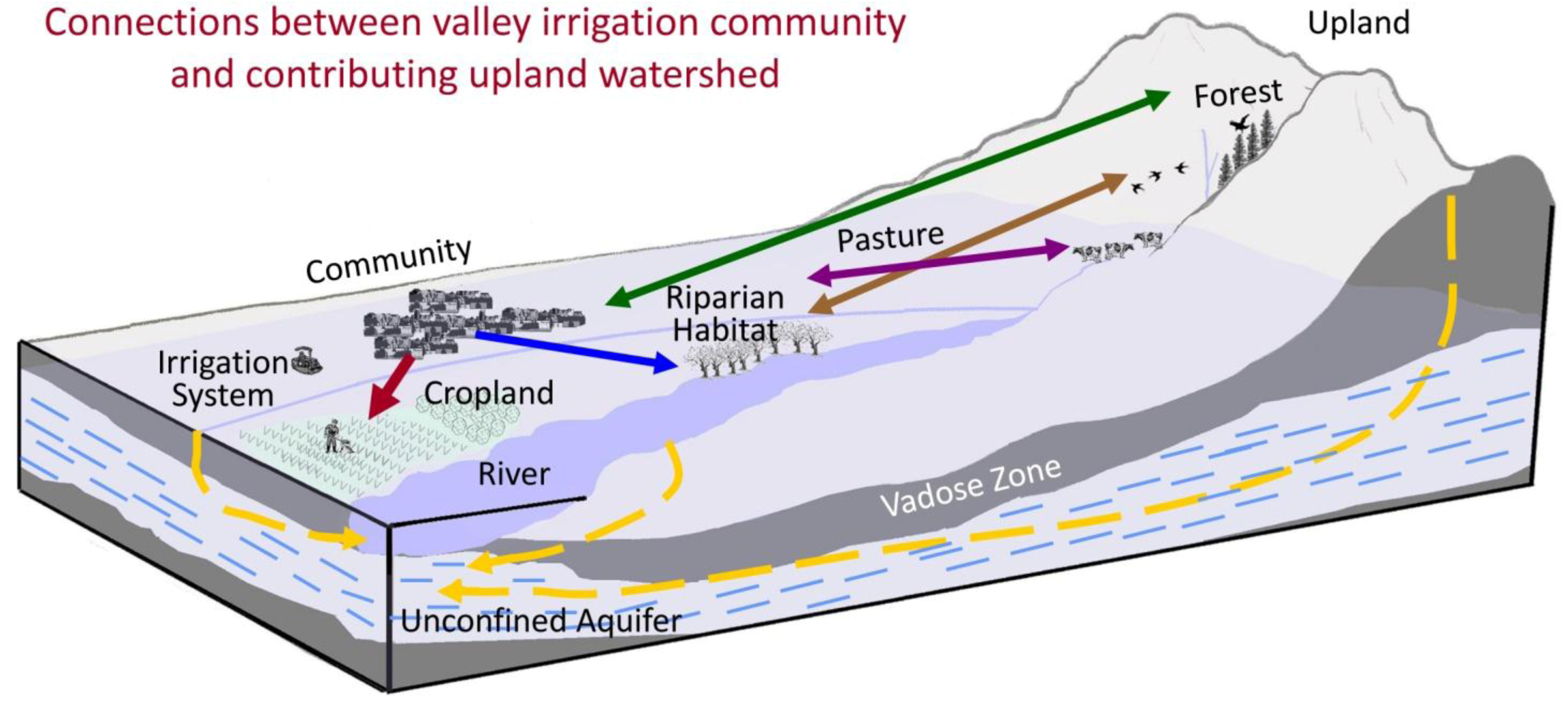
1.7. Connections between Valley Communities and Their Upland Watersheds
1.8. Study Approach
2. Methods
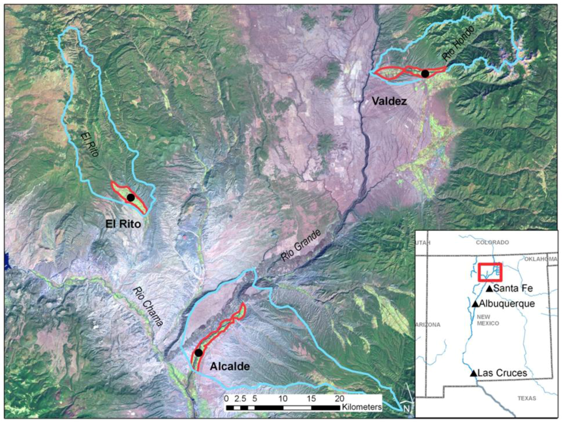
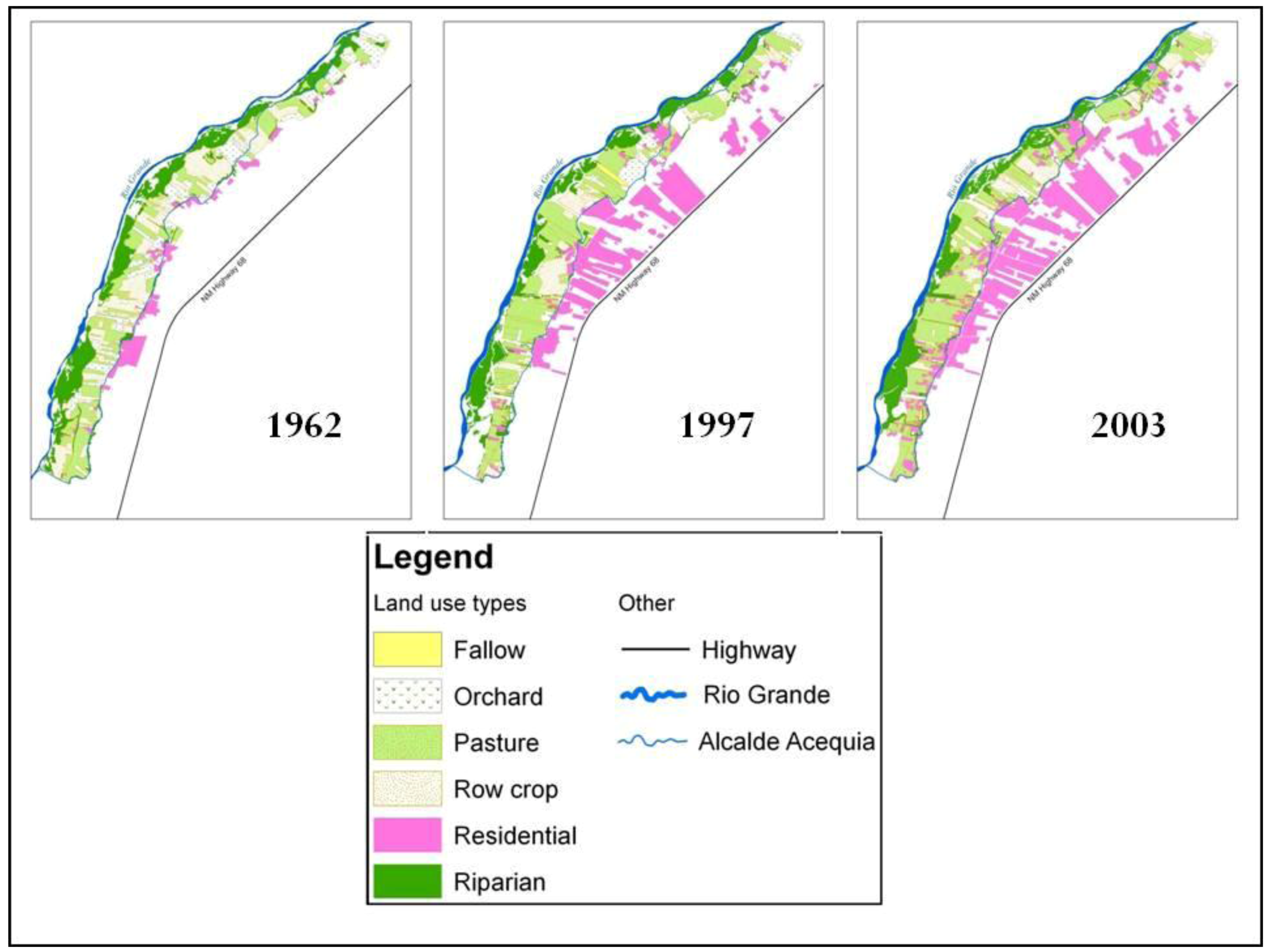
2.1. Study Sites
2.2. Multidisciplinary Modeling Dynamics
3. Subsystem Causal Loop Diagrams
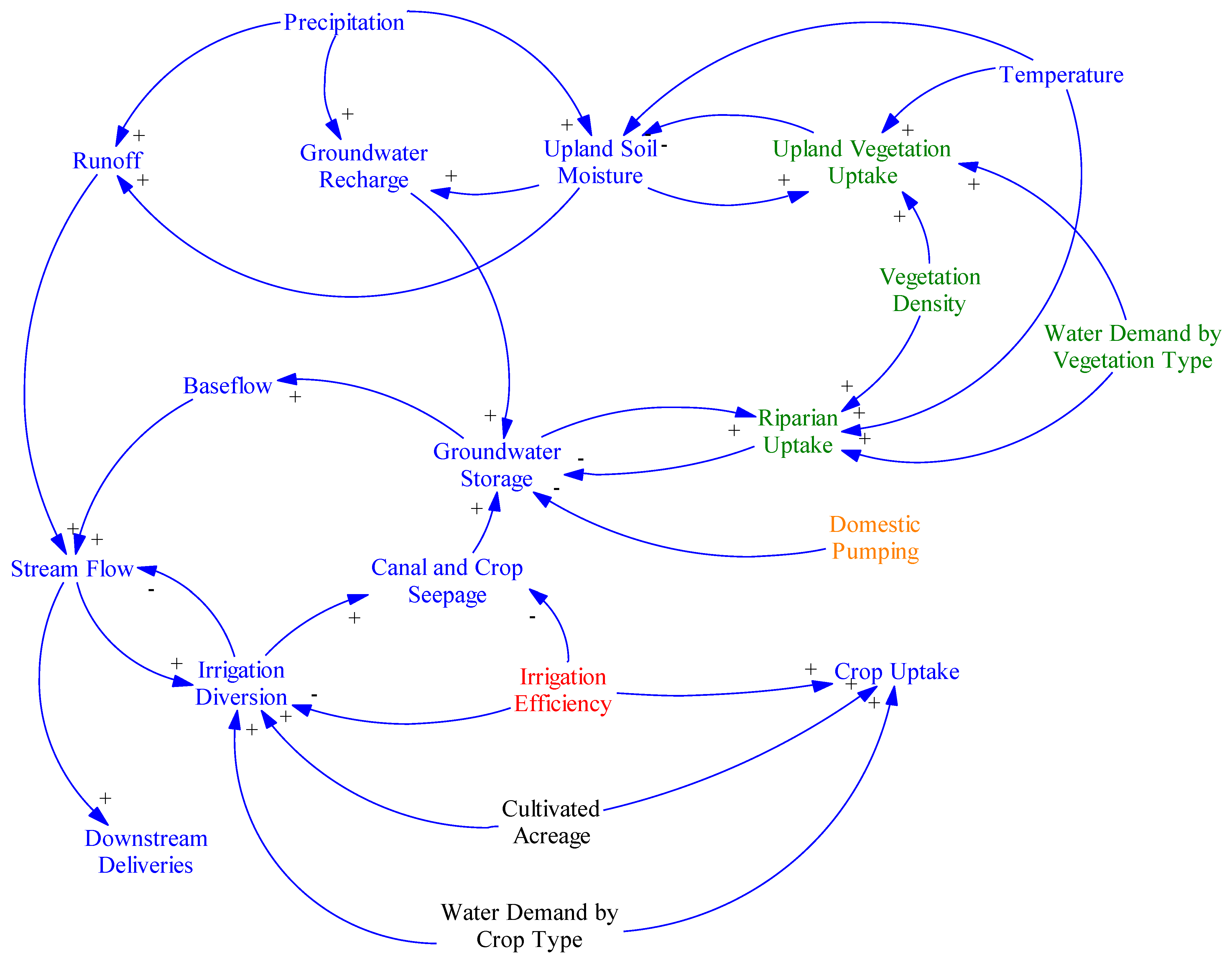
3.1. Hydrology
3.1.1. Purpose, Drivers, Outputs, Scope, Connectivity, Key Variables
3.1.2. System Function and Causality for Diagram

3.1.3. Interactions with Other Systems
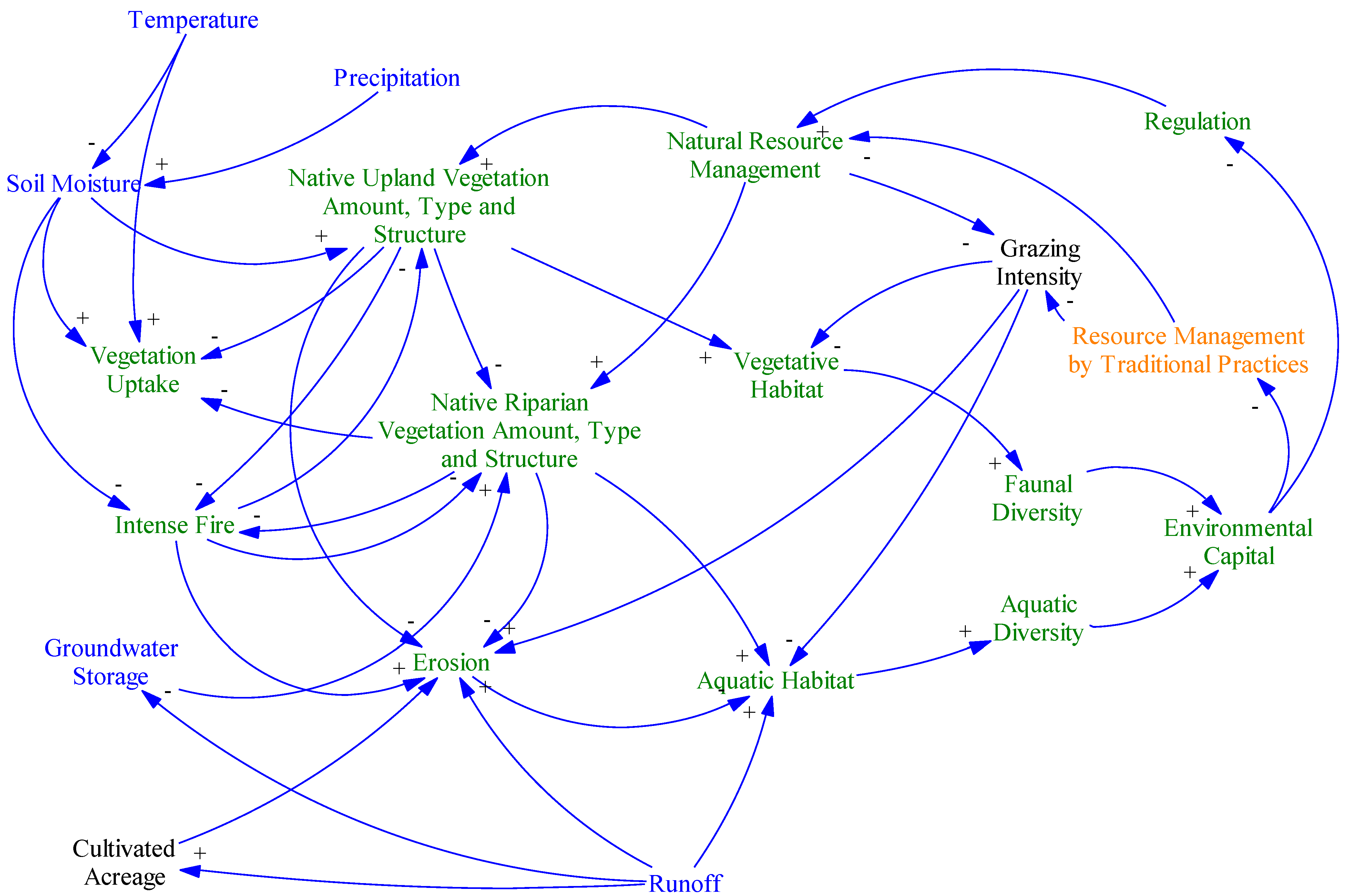
3.2. Ecosystem
3.2.1. Purpose, Drivers, Outputs, Scope, Connectivity, Key Variables

3.2.2. System Function and Causality for Diagram
3.2.3. Interactions with Other Systems
3.3. Land Use/Economics
3.3.1. Purpose, Drivers, Outputs, Scope, Connectivity, Key Variables
3.3.2. System Function and Causality for Diagram
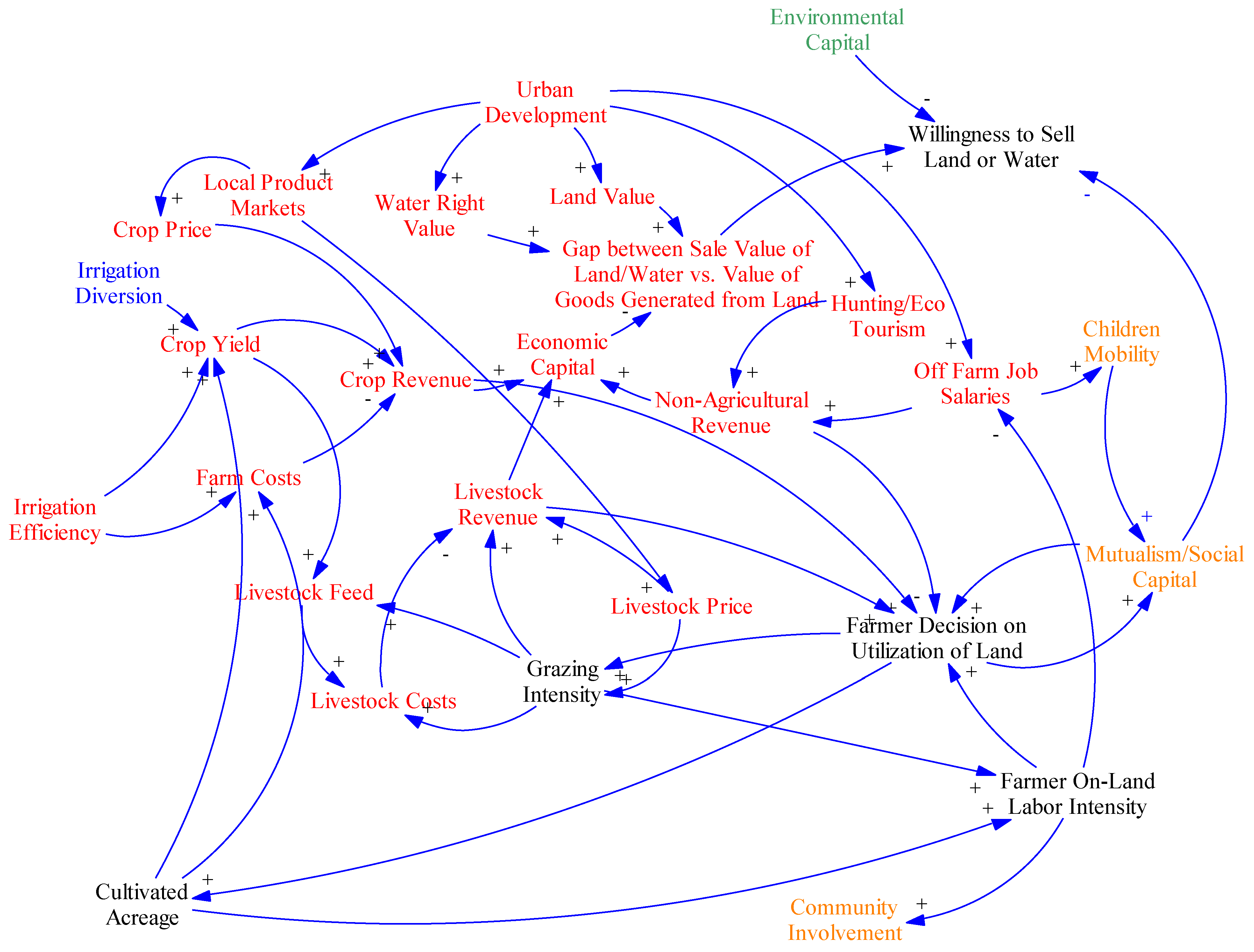
3.3.3. Interactions with Other Systems
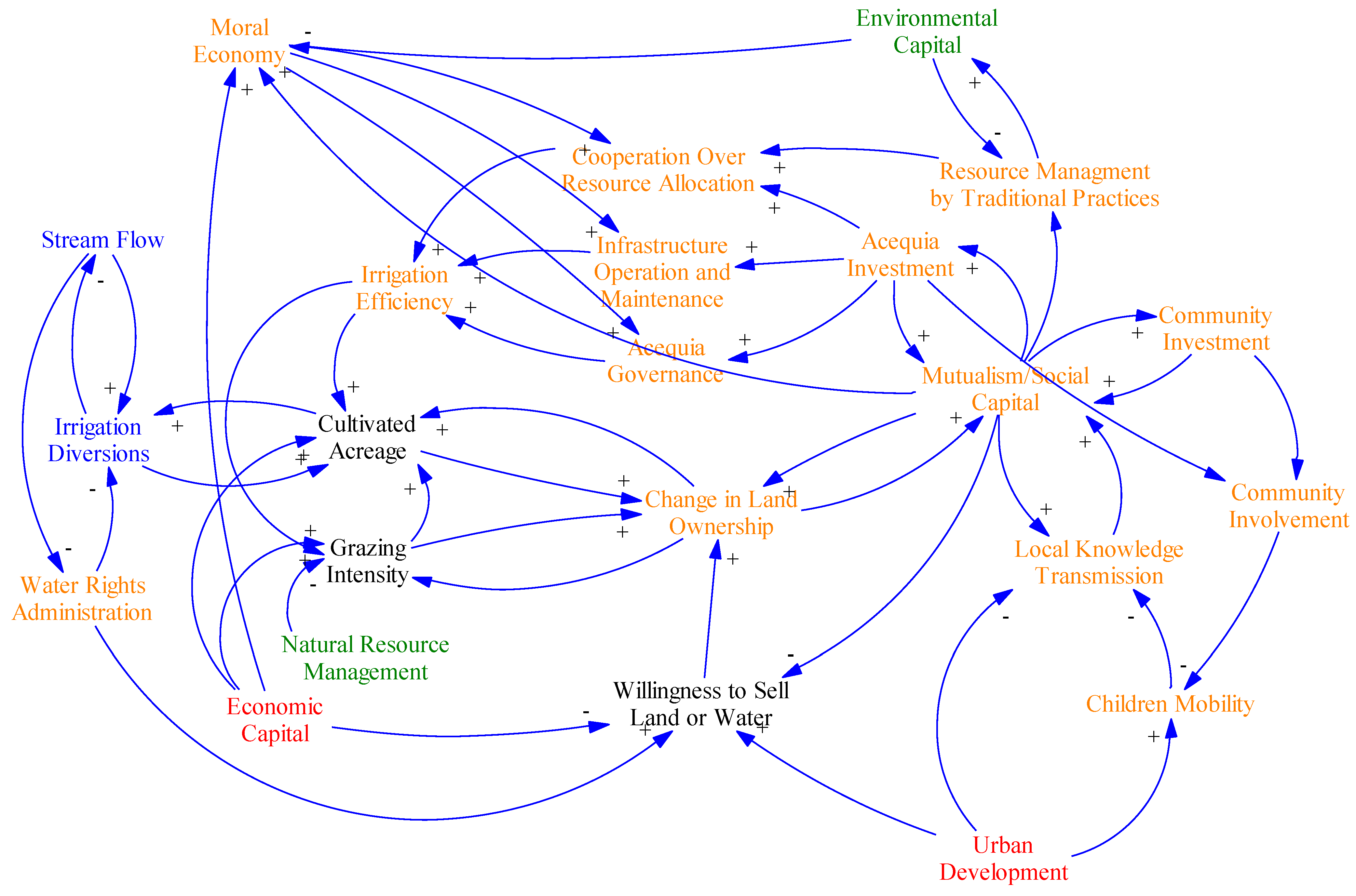
3.4. Sociocultural
3.4.1. Purpose, Drivers, Outputs, Scope, Connectivity, Key Variables
3.4.2. System Function and Causality for Diagram
3.4.3. Interactions with Other Systems
4. Future Directions
Acknowledgments
Conflict of Interest
References
- Ackerly, N.W. A Review of the Historic Significance and Management Recommendations for Preserving New Mexico’s Acequia Systems; Prepared by Dos Rios Consultants Inc; Historic Preservation Division: Santa Fe, NM, USA, 1996. [Google Scholar]
- Cox, M.; Ross, J.M. Robustness and vulnerability of community irrigation systems: The case of the Taos valley acequias. J. Environ. Econ. Manag. 2011, 61, 254–266. [Google Scholar] [CrossRef]
- Ortiz, M.A.; Brown, C.; Fernald, A.; Baker, T.; Creel, B.; Guldan, S. Land use change impacts on acequia water resources in northern New Mexico. J. Contemp. Water Res. Edu. 2007, 137, 47–54. [Google Scholar]
- Rivera, J.A. Acequia Culture: Water, Land, and Community in the Southwest; University of New Mexico Press: Albuquerque, NM, USA, 1998. [Google Scholar]
- Smith, J.B.; Wagner, C. Scenarios for the National Commission on Energy Policy; Stratus Consulting: Boulder, CO, USA, 2006. [Google Scholar]
- U.S. Census Bureau. State and County Quick Facts. Available online: http://quickfacts.census.gov/qfd/states/35000.html (accessed on 10 October 2011).
- Pulido-Bosch, A.; Ben Sibh, Y. Centuries of artificial discharge on the southern edge of the Sierra Nevada (Granada, Spain). Environ. Geol. 1995, 26, 57–63. [Google Scholar] [CrossRef]
- Eastman, C.; Gray, J.R. Community Grazing: Practice and Potential in New Mexico; University of New Mexico Press: Albuquerque, NM, USA, 1987. [Google Scholar]
- Hutchins, W. The community acequia: Its origins and development. Southwestern Hist. Quart. 1928, 31, 261–284. [Google Scholar]
- Simmons, M. Spanish irrigation practices in New Mexico. New Mex. Hist. Rev. 1972, 47, 135–150. [Google Scholar]
- Crawford, S. Mayordomo: Chronicle of an Acequia in Northern New Mexico; University of New Mexico Press: Albuquerque, NM, USA, 1988. [Google Scholar]
- Rodriguez, S. Acequia: Water Sharing, Sanctity, and Place; School for Advanced Research Press: Santa Fe, NM, USA, 2006. [Google Scholar]
- Alam, M.M.; Bhutta, M.N. Comparative evaluation of canal seepage investigation techniques. Agr. Water Manage. 2004, 66, 65–76. [Google Scholar] [CrossRef]
- Singh, R.; Kroes, J.G.; van Dam, J.C.; Feddes, R.A. Distributed ecohydrological modelling to evaluate the performance of irrigation system in Sirsa district, India: I. Current water management and its productivity. J. Hydrol. 2006, 329, 692–713. [Google Scholar] [CrossRef]
- Fernald, A.G.; Baker, T.T.; Guldan, S.J. Hydrologic, riparian, and agroecosystem functions of traditional acequia irrigation systems. J. Sustain. Ag. 2007, 30, 147–171. [Google Scholar] [CrossRef]
- Willis, T.M.; Black, A.S.; Meyer, W.S. Estimates of deep percolation beneath cotton in the Macquarie Valley. Irrig. Sci. 1997, 17, 141–150. [Google Scholar] [CrossRef]
- Asare, D.K.; Sitze, D.O.; Monger, C.H.; Sammis, T.W. Impact of irrigation scheduling practices on pesticide leaching at a regional level. Agr. Water Manage. 2000, 43, 311–325. [Google Scholar]
- Mankin, K.R.; Koelliker, J.K. A hydrologic balance approach to saline seep remediation design. Appl. Eng. Agr. 2000, 16, 129–133. [Google Scholar]
- Ochoa, C.G.; Fernald, A.G.; Guldan, S.J.; Shukla, M.K. Deep percolation and its effects on shallow groundwater level rise following flood irrigation. Trans. ASABE 2007, 50, 73–81. [Google Scholar]
- Schmidt, K.D.; Sherman, I. Effect of irrigation on groundwater quality in California. J. Irrigat. Drain. Eng. 1997, 113, 16–29. [Google Scholar] [CrossRef]
- Drost, B.W.; Cox, S.E.; Schurr, K.M. Changes in Ground-Water Levels and Ground-Water Budgets, from Predevelopment to 1986, in Parts of the Pasco Basin, Washington; U.S. Department of the Interior,U.S. Geological Survey: Tacoma, WA, USA, 1997. [Google Scholar]
- Harvey, E.F.; Sibray, S.S. Delineating groundwater recharge from leaking irrigation canals using water chemistry and isotopes. Ground Water 2001, 39, 408–421. [Google Scholar] [CrossRef]
- Maurer, D.K. Ground-Water Flow and Numerical Simulation of Recharge from Streamflow Infiltration Near Pine Nut Creek, Douglas County, Nevada; Water Resour. Invest. Rep. 02-4145; U.S. Geological Survey: Carson City, NE, USA, 2002. [Google Scholar]
- Fernald, A.G.; Guldan, S.J. Surface water-groundwater interactions between irrigation ditches, alluvial aquifers, and streams. Rev. Fish. Sci. 2006, 14, 79–89. [Google Scholar] [CrossRef]
- Helmus, A.M.; Fernald, A.G.; VanLeeuwen, D.M.; Abbott, L.B.; Ulery, A.L.; Baker, T.T. Surface water seepage effects on shallow ground-water quality along the Rio Grande in northern New Mexico. J. Am. Water Resour. Assoc. 2009, 45, 407–418. [Google Scholar] [CrossRef]
- Kendy, E.; Bredehoeft, J.D. Transient effects of groundwater pumping and surface-water-irrigation returns on streamflow. Water Resour. Res. 2006, 42, 1–11. [Google Scholar]
- Wissmar, R.C. Riparian corridors of Eastern Oregon and Washington: Functions along lowland-arid to mountain gradients. Aquat. Sci. 2004, 6, 373–387. [Google Scholar] [CrossRef]
- Peck, D.E.; Lovvorn, J.R. The importance of flood irrigation in water supply to wetlands in the Laramie Basin, Wyoming, USA. Wetlands 2001, 3, 370–378. [Google Scholar]
- Fernald, A.G.; Cevik, S.Y.; Ochoa, C.G.; Tidwell, V.C.; King, J.P.; Guldan, S.J. River hydrograph retransmission functions of irrigated valley surface water-groundwater interactions. J. Irrigat. Drain. Eng. 2010, 136, 823–835. [Google Scholar] [CrossRef]
- Hurd, B.H.; Coonrod, J. Climate change risks New Mexico’s waterways: Its byways and its flyways. Water Resour. Impact 2008, 10, 5–11. [Google Scholar]
- Ward, F.A.; Pulido-Velasquez, M. Water conservation in irrigation can increase water use. P. Natl. Acad. Sci. USA 2008, 25, 18215–18220. [Google Scholar]
- Rivera, J.A. Irrigation communities of the upper Rio Grande bioregion: Sustainable resource use in the global context. Nat. Resour. J. 1996, 36, 491–520. [Google Scholar]
- Bokum, C. Implementing the public welfare requirement in New Mexico’s water code. Nat. Resour. J. 1996, 36, 681–706. [Google Scholar]
- Siy, R.Y. Community Resource Management: Lessons from the Zanjeras; University of Philippines Press: Quezon City, Philippines, 1982. [Google Scholar]
- Ostrom, E. Crafting Institutions for Self-Governing Irrigation Systems; Institute for Contemporary Studies: San Francisco, CA, USA, 1992. [Google Scholar]
- Yan Tang, S. Institutions and Collective Action: Self-Governance in Irrigation; Institute for Contemporary Studies: San Francisco, CA, USA, 1992. [Google Scholar]
- Boelens, R.; Dávila, G.; Menchú, R. Searching for Equity: Conceptions of Justice and Equity in Peasant Irrigation; Van Gorcum and Co.: Assen, The Netherlands, 1998. [Google Scholar]
- Groenfeldt, D. Multifunctionality of agricultural water: Looking beyond food production and ecosystem services. Irrig. Drain. 2006, 55, 73–83. [Google Scholar] [CrossRef]
- Peña, D. Cultural landscapes and biodiversity: The ethnoecology of an upper Río Grande watershed commons. In La Gente: Hispano History and Life in Colorado; De Baca, V.C., Ed.; Colorado Historical Society: Denver, CO, USA, 1998; pp. 241–271. [Google Scholar]
- Nocera, J.J.; Dawe, K.L. Managing for habitat heterogeneity in grassland agro-ecosystems influences the abundance of masked shrews. J. Sustain. Agr. 2008, 32, 379–392. [Google Scholar] [CrossRef]
- Krzysik, A.J. Biodiversity in Riparian Communities and Watershed Management. In Watershed Planning and Analysis in Action; Proceedings of the 1990 Watershed Management Symposium, Durango, CO, USA, 9-11 July 1990; Riggins, R.E., Jones, E.B., Singh, R., Rechard, P.A., Eds.; American Society of Civil Engineers: New York, NY, USA; pp. 533–548.
- Allen, D.R.; Marlow, C.B. Effects of Cattle Grazing on Shoot Population Dynamics of Beaked Sedge. In Proceedings of the Symposium on Ecology and Management of Riparian Shrub Communities, Sun Valley, ID, USA, 29-31 May 1991; Clary, W.P., McArthur, E.D., Bedunah, D., Wambolt, C.L., Eds.; Intermountain Research Station: Ogden, Utah, USA; pp. 89–91, U.S. Forest Service General Technical Report INT-289.
- New Mexico Department of Game and Fish, Comprehensive Wildlife Conservation Strategy for New Mexico; New Mexico Department of Game and Fish: Santa Fe, NM, USA, 2006.
- Van Ness, J.R. Series Editor, New Mexico Land Grant Series, University of New Mexico Press. Personal communication, 1987. [Google Scholar]
- Van Ness, J.R. Hispanos in Northern New Mexico,The Development of Corporate Community and Multicommunity; AMS Press, Inc.: New York, NY, USA, 1991. [Google Scholar]
- Kutsche, P.; Van Ness, J.R. Cañones,Values Crisis,and Survival in a Northern New Mexico Village; UNM Press: Albuquerque, NM, USA, 1981. [Google Scholar]
- Sterman, J.D. Business Dynamics, Systems Thinking and Modeling for a Complex World; McGraw-Hill: Boston, MA, USA, 2000. [Google Scholar]
- Tidwell, V.C.; Van den Brink, C. Cooperative modeling: Linking science, communication and ground water planning. Ground Water 2008, 46, 174–182. [Google Scholar] [CrossRef]
- Powersim Software. Available online: http://www.powersim.com/ (accessed on 12 March 2012).
- Maurer, E.P.; Brekke, L.; Pruitt, T.; Duffy, P.B. Fine-resolution climate projections enhance regional climate change impact studies. Eos Trans.AGU 2007, 88, 504. [Google Scholar]
- Maurer, E.P.; Hidalgo, H.G.; Das, T.; Dettinger, M.D.; Cayan, D.R. The utility of daily large-scale climate data in the assessment of climate change impacts on daily streamflow in California. Hydrol. Earth Syst. Sci. Discuss 2010, 14, 1125–1138. [Google Scholar] [CrossRef]
- Devito, K.J.; Creed, I.F.; Fraser, C.J.D. Controls on runoff from a partially harvested aspen forested headwater catchment, Boreal Plain, Canada. Hydrol. Process. 2005, 19, 3–25. [Google Scholar] [CrossRef]
- Jencso, K.G.; McGlynn, B.L.; Gooseff, M.N.; Wondzell, S.M.; Bencala, K.E.; Marshall, L.A. Hydrologic connectivity between landscapes and streams: Transferring reach- and plot-scale understanding to the catchment scale. Water Resour. Res. 2009, 45, 1–16. [Google Scholar]
- Ocampo, J.C.; Syvalpan, M.; Oldham, C. Hydrological connectivity of upland-riparian zones in agricultural catchments: Implications for runoff generation and nitrate transport. J. Hydrol. 2006, 331, 643–658. [Google Scholar] [CrossRef]
- Arumí, J.L.; Rivera, D.; Holzapfel, E.; Boochs, P.; Billib, M.; Fernald, A. Effect of irrigation canal network on surface and groundwater connections in the lower valley of the Cachapoal River, Chile. Chil. J. Agr. Res. 2009, 69, 12–20. [Google Scholar]
- Fernald, A.G.; Wigington, P.J., Jr.; Landers, D.H. Transient storage and hyporheic flow along the Willamette River, Oregon: Model estimates and field measurements. Water Resour. Res. 2001, 37, 1681–1694. [Google Scholar] [CrossRef]
- Millennium Ecosystem Assessment, Ecosystems and Human Well-Being: Our Human Planet: Summary for Decision Makers; Island Press: Washington, DC, USA, 2005.
- Boykin, K.G.; Thompson, B.C.; Deitner, R.A.; Schrupp, D.; Bradford, D.; O’Brien, L.; Drost, C.; Propeck-Gray, S.; Rieth, W.; Thomas, K.; et al. Chapter 3. Predicted Animal Habitat Distributions and Species Richness. In Southwest Regional Gap Analysis Final Report; Prior-Magee, J.S., Ed.; U.S. Geological Survey, Gap Analysis Program: Moscow, ID, USA, 2005. [Google Scholar]
- Stromberg, J.C.; Lite, S.J.; Dixon, M.D. Effects of stream flow patterns on riparian vegetation of a semiarid river: Implications for a changing climate. River Res. and Appl. 2010, 26, pp. 712–729. Available online: http://onlinelibrary.wiley.com/doi/10.1002/rra.1272/pdf (accessed on 12 March 2012).
- Briske, D.D.; Fuhlendorf, S.D.; Smeins, F.E. State-and-transition models, thresholds, and rangeland health: A synthesis of ecological concepts and perspectives. Rangeland Ecol. Manag. 2005, 58, 1–10. [Google Scholar] [CrossRef]
- Cibils, A.F.; Miller, J.A.; Encinias, A.M.; Boykin, K.G.; Cooper, B.F. Monitoring heifer grazing distribution at the Valles Caldera National Preserve. Rangelands 2008, 30, 19–23. [Google Scholar]
- Eastman, C.A. Economics of Small-Scale Irrigated Agriculture in Taos County. M.S. Thesis, New Mexico State University, Las Cruces, NM, USA, 1995. [Google Scholar]
- Roach, J.; Tidwell, V. A compartmental-spatial system dynamics approach to ground water modeling. Ground Water 2009, 47, 686–698. [Google Scholar] [CrossRef]
© 2012 by the authors; licensee MDPI, Basel, Switzerland. This article is an open-access article distributed under the terms and conditions of the Creative Commons Attribution license (http://creativecommons.org/licenses/by/3.0/).
Share and Cite
Fernald, A.; Tidwell, V.; Rivera, J.; Rodríguez, S.; Guldan, S.; Steele, C.; Ochoa, C.; Hurd, B.; Ortiz, M.; Boykin, K.; et al. Modeling Sustainability of Water, Environment, Livelihood, and Culture in Traditional Irrigation Communities and Their Linked Watersheds. Sustainability 2012, 4, 2998-3022. https://doi.org/10.3390/su4112998
Fernald A, Tidwell V, Rivera J, Rodríguez S, Guldan S, Steele C, Ochoa C, Hurd B, Ortiz M, Boykin K, et al. Modeling Sustainability of Water, Environment, Livelihood, and Culture in Traditional Irrigation Communities and Their Linked Watersheds. Sustainability. 2012; 4(11):2998-3022. https://doi.org/10.3390/su4112998
Chicago/Turabian StyleFernald, Alexander, Vincent Tidwell, José Rivera, Sylvia Rodríguez, Steven Guldan, Caitriana Steele, Carlos Ochoa, Brian Hurd, Marquita Ortiz, Kenneth Boykin, and et al. 2012. "Modeling Sustainability of Water, Environment, Livelihood, and Culture in Traditional Irrigation Communities and Their Linked Watersheds" Sustainability 4, no. 11: 2998-3022. https://doi.org/10.3390/su4112998