From Confining to Sharing for Sustainable Flood Management

Graduate School of Global Environmental Studies, Sophia University, 7-1 Kioicho, Chiyoda-ku, Tokyo 102-8554, Japan
Sustainability 2012, 4(7), 1397-1411; https://doi.org/10.3390/su4071397
Submission received: 13 April 2012
/
Revised: 29 May 2012
/
Accepted: 18 June 2012
/
Published: 26 June 2012
Abstract
:It is widely accepted that sustainable development is the development that meets the needs of the present without compromising the ability of future generations to meet their own needs. However, the question of how to apply this principle to flood management remains insufficiently answered. This article outlines a new strategic concept termed as “Flood Sharing” as a means toward sustainable flood management. Contrary to the traditional concept of flood confinement or blocking, the new concept advocates the need to alleviate flood damage by reducing inundation depth via expanding flood inundation areas. It differs from other contemporary thinking such as “make space for water” and “room for the river” in its emphasis on using the urban fabric. Evidence from a case study was presented to support this new concept, and model/data analyses have been conducted to show that it could be realized through the wise use of infrastructure.
1. Introduction
Flooding is one of the major natural hazards that human beings have been coping with for centuries. What is the current situation? By any number of accounts, the world in general appears to be facing even greater challenges from flooding today than it did a generation ago. For instance, the Venezuela floods in December 1999 cost over 30,000 lives, destroyed 23,200 houses, and damaged another 64,700 [1]. In 2010, Pakistan was awash with the worst flooding in more than a century, leading to at least 1600 deaths and 12 million affected. The United Nations has rated the floods in Pakistan in 2010 as the greatest humanitarian crisis in recent history [2]. In 2011, Flood waters in Thailand have swamped more than two-thirds of the country, submerging rice fields and shutting down hundreds of factories, while over 900,000 families and businesses have been impacted and hundreds of lives have been tragically lost. These are good examples of the escalated severity of flood disasters. The intensifying flood impacts are often attributed to urbanization across the world. Urban watersheds, on an average, lose 90% of the storm rainfall to runoff, whereas the non-urban forested watersheds retain 25% of the rainfall [3]. A new dimension of challenges is the increase of flood risk due to climate change. According to an IPCC report, both floods and droughts will become more severe in areas that are already prone to such disasters.
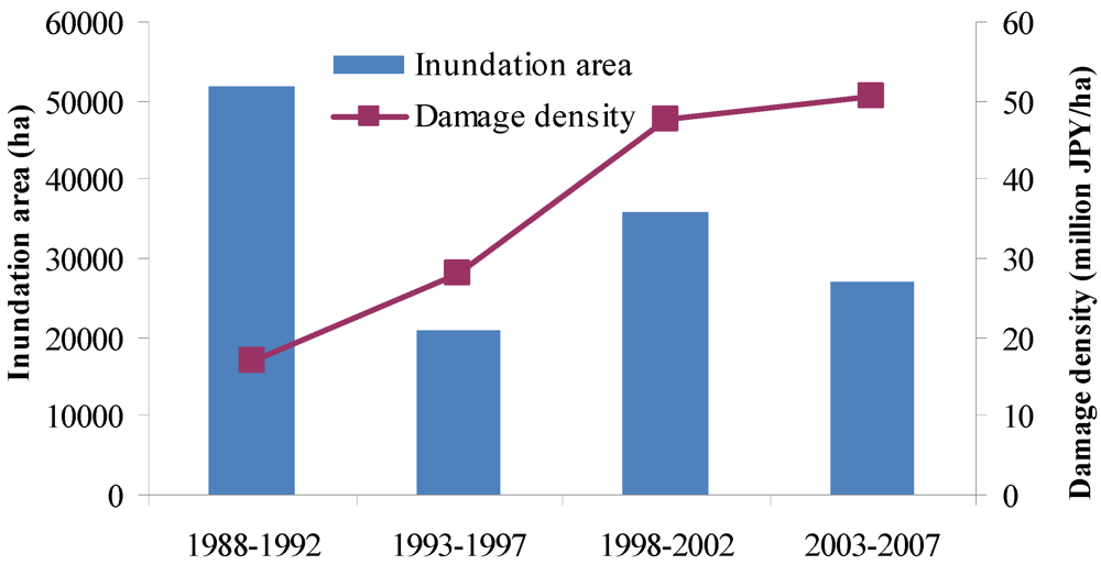
In developed counties such as Japan, however, flood disasters exhibit two trends. As shown in Figure 1, there is a decreasing trend in the inundation area and an increasing trend in the flood damage density (million JPY per ha) over the last several decades. This contrast is often explained as being caused by urbanization, which led to the concentration of assets in flood-prone areas.
Figure 1.
Trends of inundation area and damage density in Japan.

Traditional flood management approaches focused on reducing flooding and reducing the susceptibility to flood damage through structural countermeasures. These were often ad hoc reactions and carried out in isolation. Flood confinement or blocking may be considered as the keywords to describe traditional flood management.
For instance, ring dike and double-dike have been used to prevent flood waters from entering certain target area. The Netherlands is well known for its wide use of the ring dike approach [4]. As a result, the entire nation has been subdivided into dike-ring areas. The use of ring dike in Japan has a long history as well, dating back to the 16th century. Noubi plain is famous in Japan for the large number of dike rings constructed during the Edo Era [5]. Another traditional countermeasure is the so-called double-dike, which was first used in the Yellow River in China dating back to the North Song Dynasty (960–1127) and also used in Japanese rivers since the Edo Era [6]. In recent years, ring dike and double-dike have been highlighted again in Japan as important techniques toward the realization of the concept of “living with floods” [7].
More broadly speaking, storage tanks, constructed wetlands, retention ponds, dike rings and double-dikes have been viewed as the state of the art for flood risk reduction. A common concept inherent in these approaches is to localize floods or block flood waters from entering certain areas. In the Netherlands, the design of dikes is linked to the frequency of occurrence of a certain flood stage. The particular frequencies of occurrence, or risk levels, are determined by the national Parliament. Levees along the coasts of densely-populated and highly industrialized parts of the country are to be designed to protect from all storms whose magnitudes would be exceeded only once in 10,000 years on average. It is a traditional mindset that higher dikes are safer. However, in reality, higher and higher dikes would result in unjustifiable risks in the event of a dike breach. When a dike breaks, this flood defense structure does not act as a protection, but rather as an amplifier of destruction.
During recent decades, the concept of integrated flood management for sustainability has been gaining momentum. It calls for a paradigm shift from the traditional, fragmented and localized approach, and encourages the use of the resources of a river basin as a whole, employing strategies to maintain or augment the productivity of floodplains, while at the same time providing protective measures against losses due to flooding. However, sustainable flood management (SFM) is not well-defined and may mean different things to different people. The following definition of SFM was proposed by the National Technical Advisory Group of Scotland (NTAG): “Sustainable flood management provides the maximum possible social and economic resilience against flooding, by protecting and working with the environment, in a way which is fair and affordable both now and in the future”. Delft Hydraulic Laboratory [8] proposed a sustainability checklist embracing five main criteria for the evaluation of flood protection systems as described below:
- Socio-economic aspects and impacts on growth, resilience and stability;
- Use of natural and environmental resources, including raw materials and discharge of wastes within the carrying capacity of natural systems;
- Enhancement and conservation of natural and environmental resources;
- Public health, safety and well being;
- Flexibility and sustainability of infrastructural works, management opportunities for multifunctional use, and opportunities to adapt to changing circumstances.
Samuels [9] suggests sustainable flood defenses should involve:
- Ensuring quality of life by reducing flood damages but being prepared for floods
- Mitigating the impact of flood defense activities on ecological systems at a variety of spatial and temporal scales
- The wise use of resources in providing, maintaining and operating flood defense infrastructure maintaining economic activity (agricultural, industrial, commercial, residential) on the flood plain.
In my opinion, for flood management to be truly sustainable, it must balance between flood protection for the present generation and leaving a sufficient degree of freedom to future generations with regard to flood management practice, because we do not know what future generations will want or value, and what technologies future generations will have; some of today’s management objectives and practices may be wrong or may change over time. Therefore, flexibility or reversibility should be considered as a minimum requirement of sustainable flood management. It is an extremely important but very much neglected aspect in watershed management so far. Reservoirs are practically irreversible although removal is technically possible. The total cost of removing a large-scale dam could be too expensive to be practicable.
A good sign in the Netherlands is that the traditional approach of building tall walls to contain river water has been under re-evaluation in favor of an initiative known as “Room for Rivers”, which reconnects the river channel with its surrounding floodplain by establishing empty, floodable areas on the riverbanks [10]. In the U.K., the strategic direction of Making Space for Water [11] was published in 2004, which addresses issues such as land-use planning, giving priority to locating development in areas at a lower risk of flooding, the creation of wetlands, levee setback, restoration of flood plain and funding as well. In the U.S., the government of Iowa City purchased and demolished homes in the 100-year floodplain after the 2008 floods, using the Federal Emergency Management Agency’s (FEMA) Hazard Mitigation Grant Program [12]. It effectively reduced the number of local flood prone residences and these areas are now being used as neighborhood parks. These initiatives are important steps toward the establishment of flood resistant and flood resilient societies. However, a common limitation of these concepts and initiatives is that they place the emphasis on restoring or increasing the capacity of flood plains to accommodate more flood waters so that they can be viewed as a clean-up of riparian zones for floods. However, attention given to and efforts exerted towards dealing with residual risk in the context of sustainability are limited. Residual risk refers to the risk of flooding that exists in an area from potential floods that exceed the design of current protection systems, due to the chance that the existing system could experience an unexpected failure. The protection system usually indicates structural measures such as dam, levee and drainage facility. Non-structural measures such as “room for the river” can now be viewed as part of the protection system. In spite of various structural and non-structural measures on planning and operational level, residual risk cannot be eliminated totally. Extremely large floods, which become highly possible due to climate change, would cause overflow and inundation in urbanized areas anyway. Furthermore, in highly-populated urban areas such as Tokyo and Yokohama in Japan, there is much less room for maneuver using the “European approach” of clearing riparian zones for greater floodwater storage. Therefore, a new concept is needed for innovating flood management to cope with residual risk that can be relayed to future generations without depleting their choices. In this study, the focal point is to establish a new concept towards dealing with the residual risk that can meet the requirement of reversibility and can work under land availability constraints.
The present paper is structured as follows: Firstly, it explains the situation described in Figure 1 from a new perspective. Secondly, it reasons that strategies different from enclosure or blocking and clean-up of riparian zones should be explored, and then it presents a new framework with innovative thinking towards the realization of “living with floods”.
2. Materials and Methodology
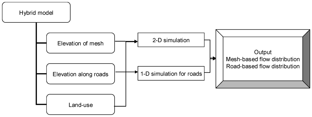
The statistical survey on flood damage in Japan started from 1875 but was suspended during World War II. The present form of flood-related statistics published by the Ministry of Land, Infrastructure, Transport and Tourism of Japan had its origin in 1957. The annual report includes flood fatalities and numbers of injured; the amount of damage to general assets, such as houses and household goods; the amount of flood damage to public civil engineering works, such as roads, and public utilities, such as electricity and gas; the amount of damage to agriculture; the inundation area; the number of damaged houses and households; the amount of damaged general assets by municipality, and so forth. Besides, municipalities have also been keeping records of flood events that occurred in their administrative areas. The national archive of flood damage surveys, municipal records and results of previous research have been combined to provide evidence and reasoning that confining or blocking of flood waters could be a problem instead of being a solution in an urban context; and to explain the fundamental difference between the concept proposed in this work and other existing contemporary ones. In addition, numerical simulations have also been performed with a so-called “Hybrid Model” to give supplemental support for the new framework. The “Hybrid Model” combines 2-D simulation for overland flow with 1-D modeling for flow along roads [13]. The 1D/2D coupling resembles the one employed in LISFLOOD-FP [14]. The general structure of the model is described in Figure 2.
Figure 2.
Essential architecture of the hybrid modeling system.

3. Evidence and Reasoning
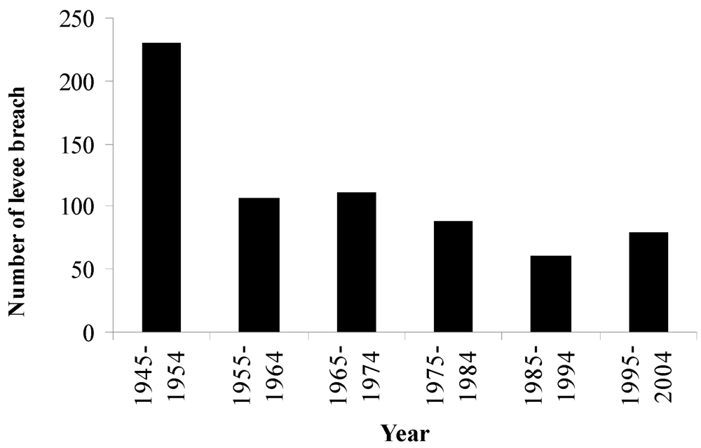
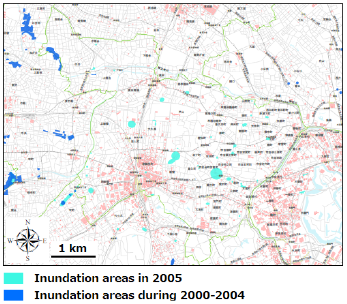
As shown in Figure 1, there is a decreasing trend in the inundation area of Japan over the last several decades. However, the flood damage density has been increasing. This contrast is often explained as due to the concentration of assets in flood-prone areas and the increase of surface imperviousness. Nevertheless, a review of flood events occurring in Japan over the past several decades has revealed that flooding was often a rural phenomenon and due mainly to levee breach or overflow before the 1970s, but turned out to be a more urban event since the late 1980s, due largely to waterlogging. Figure 3 shows that the number of levee breaches has been significantly reduced. The shift of flooding from rural to urban may be attributed to urban sprawl. Urbanization in Japan evolved from 18% in the 1920s to less than 40% in the 1950s, and then rapidly increased since the middle of the 1960s and reached more than 70% in the 1970s (based on the Population Census of Japan). In urban areas, in addition to the problems of asset concentration and surface imperviousness, complex urban structures may exert significant impacts on the behavior of flood waters in case of inundation. Either intentionally or by chance, roads, railroads and building may function as barriers to flood water spreading. Consequently, it may affect the trend of change in flood inundation areas. As an example, Figure 4 shows that the recent flooding events in the Shinjuku district of Tokyo were confined and scattered.
Figure 3.
Change in the number of levee breaches in Japan.

Figure 4.
Recent flooding records in the Shinjuku district of Tokyo.

When flood waters are confined, inundation depths increase. Duiser [15] proposed a model that relates the local mortality fraction to inundation depth. The work of Waarts [16] indicates that mortality is an exponential function of water depth. Jonkman [17] presented a relationship between water depth and mortality for the Orleans and St. Bernard bowls for the flood caused by Hurricane Katrina in the New Orleans. Meanwhile, research on the relationship between property damage and inundation depth has also been conducted extensively. There is a great variety of depth-damage relationships (with or without basements) in use around the U.S. [18,19]. Therefore, it is widely agreed that the degree of fatality and direct economic cost of flooding is proportional to inundation depth. When urban areas are segmented by infrastructure and buildings, a higher inundation depth would be expected. This gives a new and in-depth explanation why flood damage density has been increasing while the inundation area has been decreasing. And it suggests that flood managers should shift their attention from surface imperviousness to the more fundamental issue of urban form design.
Two flood inundation cases are now presented to set the framework for the new proposal outlined in the next section. Both occurred in the Niigata prefecture, Japan. The reason for selecting these two cases is that flood hazard appears to be increasing in the region. Although structural measures such as dam construction, dam operation change to increase flood regulating capacity, channel width enlargement and non-structural measures, such as flood hazard mapping and improvement of evacuation systems have been implemented, the region is still at high risk of flooding.
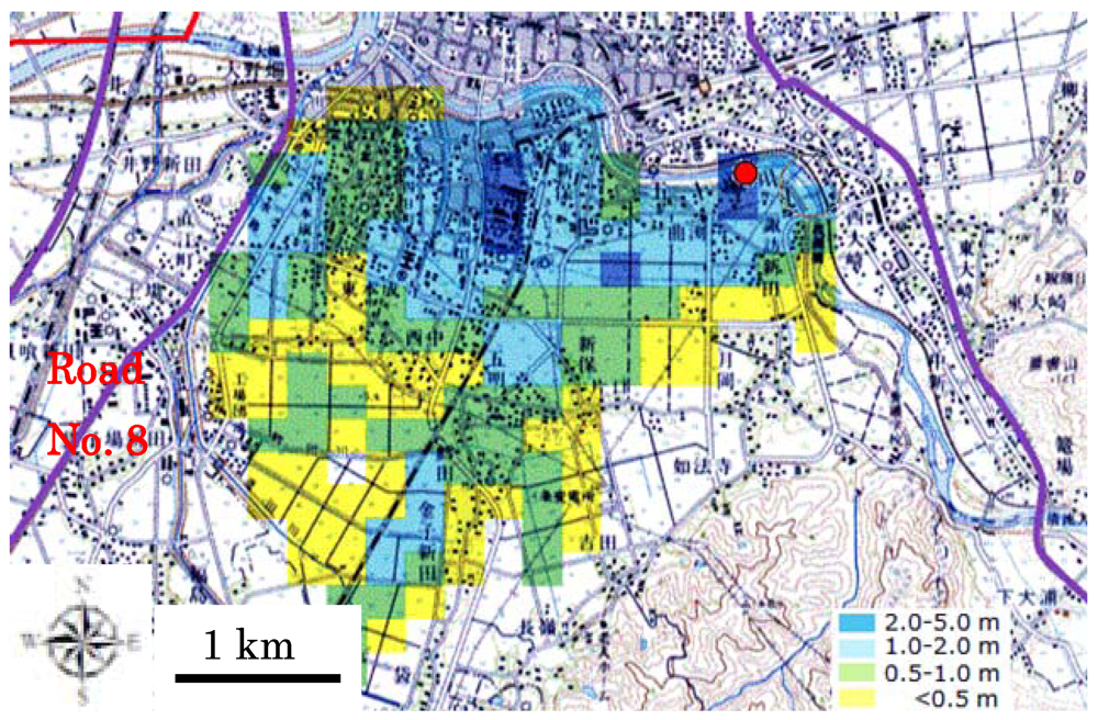
On July 13, 2004, heavy rainfall hit the Sanjo city, Niigata prefecture, which resulted in a levee breach in the Ikarashi river. The flood water spread out largely in two directions; the south and the west [20]. The water moving toward the west was stopped by the National Road No. 8 as one can notice from Figure 5. One can also notice that the inundation depths along the National Road No. 8 were about 2 m due to the blockage of water by the road. This flood disaster accounted for nine victims.
Figure 5.
Distribution of flood inundation depths in the Sanjo city, Japan, 13, July, 2004.

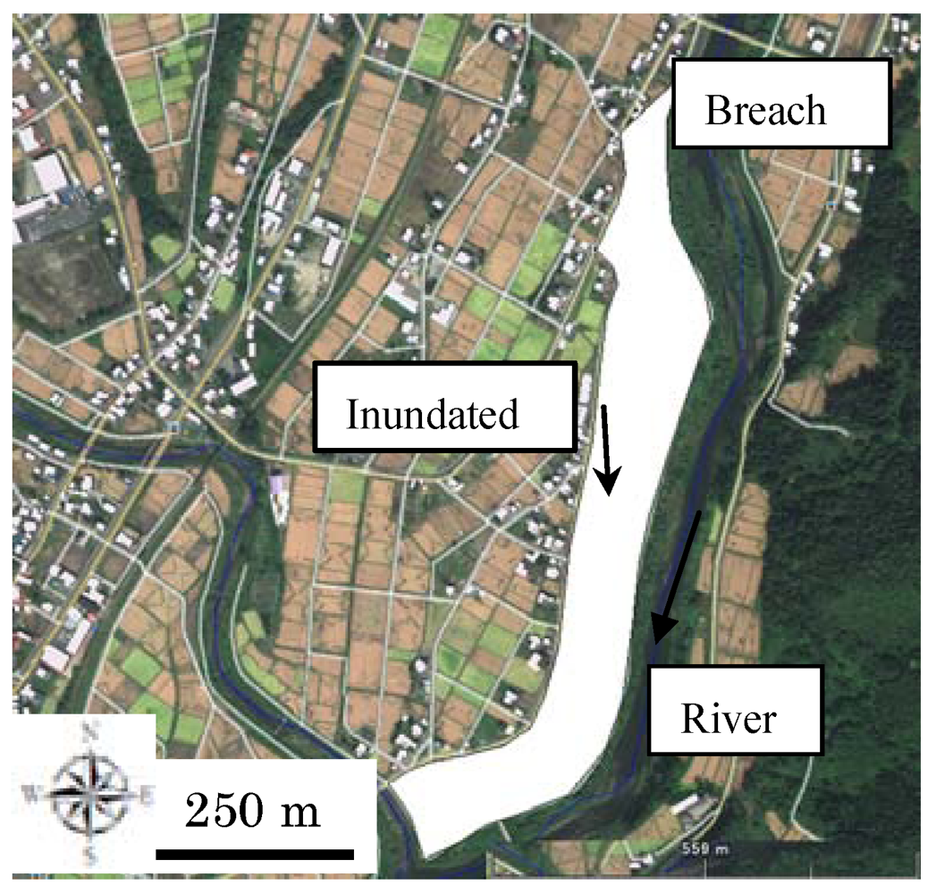
Figure 6.
Inundated area when the Abuma river breached on July 30, 2011.

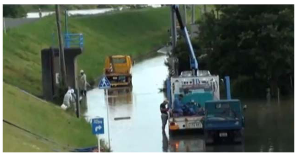
On July 30, 2011, Niigata prefecture was again hit by extreme rainfall, which resulted in a levee breach and overflow of several rivers. One of them is the Aburuma river, which runs through Uonuma city. In the early morning of July 30, a breach occurred in the lower upstream reach of the Aburuma River. The breach was about 50 m long and on the right river bank. As shown in Figure 6, the flood waters coming out of the river channel were confined to a narrow belt zone along the road. The inundation depths were above 1.5 m almost everywhere in the inundated area, according to a water mark survey. Due to high awareness of flood risk that led to quick evacuation, there was no loss of life associated to this flood event. However, 21 houses were severely inundated. Figure 7 shows that the area behind a dike suffered from waterlogging.
Figure 7.
Photo showing that an area behind dike suffered from waterlogging.

The evidence supports the argument that the contrast between the decline of inundation area and increase of flood damage could be partially caused by urban structures that block flood water propagation.
Assuming that with a total volume of flood water Qt, flooding area Am , an average inundation depth Hm, the coverage of buildings and houses S, and that there are no water enters buildings or houses, then a general relationship between these variables can be written as follows:

The coverage of buildings and houses in the Sanjo city was approximately 30% and the total volume of flood waters coming out of the Ikarashi river on July 13, 2004: 1.2 × 10⁷ m3 [21]. If the management goal is to keep the depth below 0.5 m, then, the necessary flooding area should be

It is estimated from the flood hazard map of the Sanjo city that the actual flood potential area in the city is 13 km2. Excluding the building occupancy from the flood potential area, the available space for accommodating inundating water in the Sanjo city is just 9 km2. Thus, it can be concluded that the capacity of the Sanjo city to live with flood is far from sufficient.
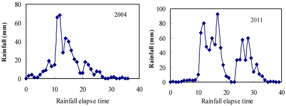
Figure 8 shows the hyetographs at a representative gauging station for the two weather events. It is seen clearly that the 2011 event can be characterized as having a multi-peak pattern as compared to the 2004 event. Besides, the rainfall peak was also higher in 2011 than 2004. For such an intensified multi-peak weather pattern, upstream dams would lose their capacities in regulating the second peak flow. It implies that a new concept, a new approach must be sought to deal with the evolving trend of flood hazards.
Figure 8.
Hyetographs of the two events at the Kasabori rainfall gauging station.

4. A New Concept
Based on the aforementioned facts, a new concept that is termed as “Flood Sharing” is proposed here. It is aimed at establishing a new framework to deal with the residual risk in case of extremely large-scale floods. The logic is that wide but shallow inundation is much less harmful than narrow but deep inundation. Because high water depth is life-threatening and the question with paramount importance in flood disaster management is “how to avoid or minimize life loss”, the philosophy of going for wide but shallow is justifiable although it could affect more people.
Mathematically, it is formulated below

where Qin = flow rate from a levee breach; A = inundation area; H = inundation depth.
From Equation (3), A can be obtained as

The rate of area expansion dA/dt is the speed of flood water propagation and dH/dt is the rate of flood water rise. From the viewpoint of safe evacuation, low speed of floodwater propagation and slow increase of depth is preferred. Equation (4) implies that the realization of low speed and slow rise require a larger inundation area. If the inundation area is confined and the maximum possible area is Amax, dA/dt becomes zero when A = Amax. Then, Equation (4) can be rearranged as

Equation (5) suggests that the smaller the area, the higher the rising speed of flood water depth.
A key toward the realization of the “wide but shallow” concept lies in road networks. Roads are basic and indispensible social infrastructures. The construction of roads has been used as a way toward prosperity across the world. However, the construction of roads alters drainage paths in a watershed. In many urbanized areas, roads account for more than 20% of land-use. For example, in the Ota city of metropolitan Tokyo, road coverage accounts for 30% of its land. During flood inundation, roads often turned out to be like river channels, resulting in traffic suspension and road damage. On August 8 2009, Sayo river in Hyogo prefecture of Japan breached and 18 died in this disaster. Among them, 9 persons lost their lives on their way to an evacuation shelter. In light of road damage and consequent difficulties of the disaster relief operation, preventing roads from being flooded has been considered as a high priority by road engineers and the general public as well. On the other hand, relatively high roads may block flood water propagation either intentionally or unintentionally. Therefore, there is an urgent need to evaluate the relationship between road patterns and urban flooding characteristics. The question to address is “Does the road accelerate flooding?” A further question is “Can we use roads in a smart way to alleviate flood disasters?” The following case study gives a preliminary answer to these two questions.
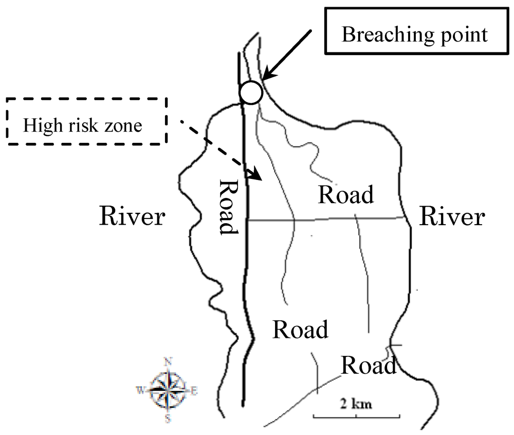
A river junction is one of the most flood-prone landscapes. A recent example was the flooding at the Junction of the Mississippi and Ohio rivers in 2011. In this study, the Shirone district in Niigata city of Japan is chosen as a target area. As shown in Figure 9, it is an area enclosed by the Shinano river and the Naganokuchi river. It is a flat lowland and very vulnerable to flooding. The road network in the district consists of National Roads No.8, No.46, No.460 and Prefectural Road No.146. Looking from the river junction, the road network in this district can be characterized as a combination of radiating type roads and ring type roads.
Figure 9.
Road network and rivers in the Shirone district.

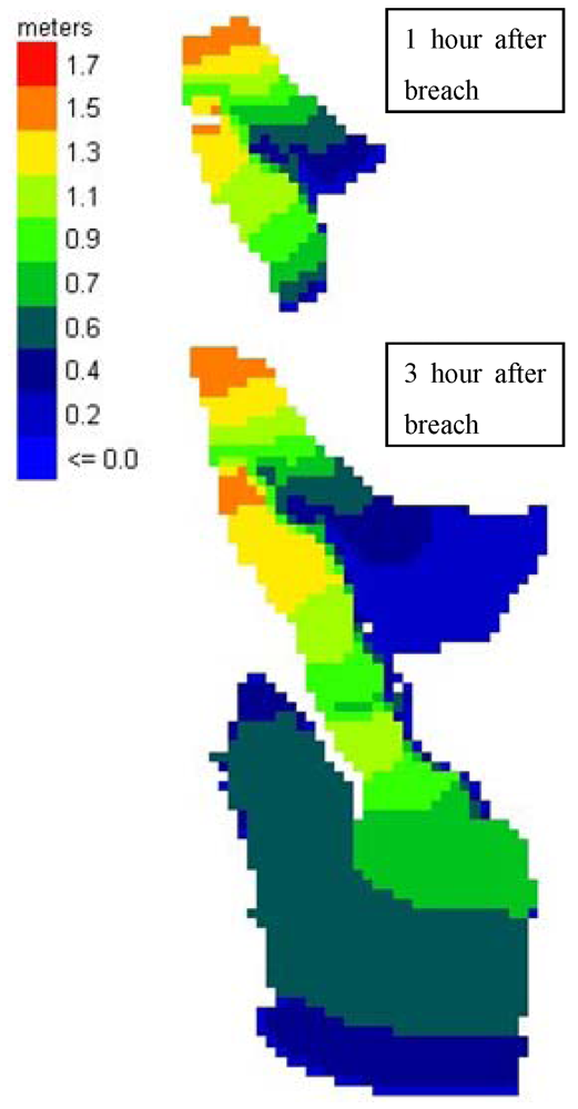
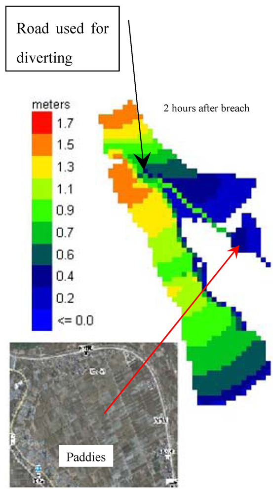
For such a geographical setting, numerical simulations of inundation scenarios were performed with the Hybrid Model. In the case of flood water coming out of the Shinano river from the junction, the numerical simulation shows that the combination of radiating roads with ring roads could confine flood waters, resulting in high inundation depths in the narrow area surrounded by roads, as illustrated in Figure 10. If there was another road slightly leaning toward the east, the numerical experiment indicates that this hypothetical road could divert some portion of flood waters to the east of the region where the land-use is mainly farmland (Figure 11).
Figure 10.
High flood water depths due to confinement by roads.

Figure 11.
Diversion of flood water by a road to a less vulnerable area.

In light of the road’s dual capability of blocking and re-directing flow, a new type of road, termed as multi-purpose road, is proposed. It would function as a normal road on normal days, but as a flood diversion channel during an emergency. Besides, roads with a flood water diversion function can be designed in a way that flow velocity along roads is under an acceptable level. The construction of multi-purpose roads may become an engine to realize the “wide but shallow” strategy. Conventionally, storm sewers are constructed to help prevent flooding by diverting rainfall runoff into nearby rivers and creeks. However, the water levels of nearby waterways are often too high during rainfall events to dump flood waters. Therefore, the integration of storm sewers and multi-purpose roads could lead to better crisis handling. Moreover, storm sewers could be also be utilized for flood sharing, which is a subject for further study. Worded differently, we need to use all available infrastructures and resources in an integrated way for flood disaster minimization.
In the case of the Sanjo city inundation on July 13, 2004, if the flood waters could have propagated through the National Road No. 8, the inundation depth on the east side of the road would have been significantly reduced. Since the land use on the west side of the National Road No. 8 is mainly farmland with a very small number of scattered houses, the diversion of flood water to that area is justifiable and can be realized by installing a road culvert. The case of the Aburuma river flooding would be characterized by deep water depth (>1.5 m) across the whole inundation area. The situation was life-threatening, particularly to children. Thus, intentionally spreading flood waters toward the west side could be considered as a life-saving measure.
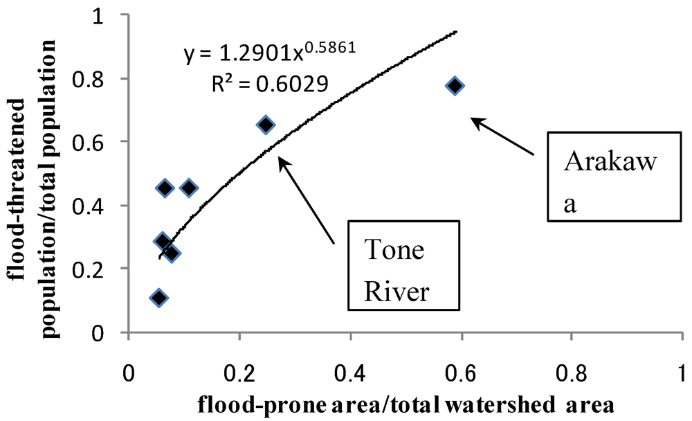
By overlapping population data with designated flood hazard maps for watersheds in the Kanto region, a relationship was obtained between the percentages of flood-threatened population and the percentages of inundation area in the Kanto region as shown in Figure 12. With the exception of the Tsurumi river, where the population density is extremely high (>8000/km2), the population in a flood-prone area of a watershed divided by the total population of that watershed increases as a power function of the ratio between the flood-prone area and the total watershed area. It can be seen clearly that the flood-threatened population percentages are 66% and 77% in the watersheds of the Tone river and the Arakawa river, respectively. The Tone river is the largest river in Japan in terms of flow discharge and drainage area. The Arakawa river is the largest river flowing into the Tokyo Bay and also possesses the widest river channel width among Japanese rivers. It can be also noted that in the watershed of the Tone river, the 66% of the flood-threatened population is concentrated in 25% of its watershed. Such an imbalance justifies the consideration of alternative approaches to conventional blocking practice.
Ikeuchi et al. [22] analyzed six scenarios of large-scale flooding in the watershed of the Tone river and showed that the worst scenario is the inundation in a topographically-enclosed area where the potential depth could be as high as 5 m and the potential loss of life might reach 6,200 if evacuation is not appropriately implemented. This may also be viewed as supporting evidence with regard to the importance of controlling inundation depth.
Due to land availability, relocation of residents to make sufficient room for flood waters would be too costly and too time-consuming to be practical in large Japanese cities like Tokyo. Instead, living with flood through flood water sharing could be a sustainable solution because flood risk sharing among the present generation could minimize the burden passed to future generations. Land-use by design, such as road manipulation to achieve sharing, is cost effective, both economically and ecologically, and it is also reversible, and thus satisfies the minimum requirement of sustainability. Besides, sharing would involve more stakeholders, which may enhance the fairness of flood management in the future.
Figure 12.
Relation between percentage of flood-threatened population and the percentage of inundation area in the Kanto region.
Figure 12.
Relation between percentage of flood-threatened population and the percentage of inundation area in the Kanto region.

5. Conclusions
The case study and model analysis of this study indicate that in highly-urbanized areas, a new approach to flood disaster management is needed. The old approach, relying on floodwater localization or blockage, now leads to unacceptably high inundation depths in certain areas. Since high water depth is life-threatening and often results in flood damage at high economic cost, a “wide but shallow” approach that reduces inundation depth and shares the burden of the risk is a new and justifiable strategy for flood risk management.
Flood sharing differs from the existing concepts of flood risk reduction, flood risk retention and flood risk transfer. It can be interpreted as a risk dispersion (or advection + diffusion) process. It aims at reducing damage resulting from large urban floods through transporting floodwaters while flattening the risk. The construction of multi-purpose roads is one of the main tactical measures needed for the realization of the flood-sharing concept, and makes it a particularly useful tool to deal with residual risk. Designing and using urban infrastructure in this way allows for adaptive management and reversibility. Another sustainability benefit of the flood-sharing approach is its built-in mechanism for large-scale public participation and more equitable risk management.
Acknowledgements
Special thanks to three anonymous reviewers for their critical comments and numerous suggestions that significantly improved the quality of the paper.
References
- OFDA/CRED. EM-DAT: International Disaster Database. Available online: http://www.cred.be/ (accessed on 1 May 2012).
- AlertNet. Available online: http://www.trust.org/alertnet/crisis-centre/crisis/pakistan-floods-2010 (accessed on 1 May 2012).
- Shang, J.; Wilson, J.P. Watershed urbanization and changing flood behavior across the Los Angeles metropolitan region. Nat. Hazards 2009, 48, 41–57. [Google Scholar] [CrossRef]
- Dijkman, J.; Klomp, R.; Villars, M. Flood Management Strategies for the Rivers Rhine and Meuse in the Netherlands. In Proceedings of the Conference on Destructive Water: Water-Caused Natural Disaster, their Abatement and Control, Anaheim, CA, USA, 24–28 June 1996.
- Kisso 79 (in Japanese); Lower Kiso River Management Office: Kuwana, Mie, Japan, 2011.
- Hamaguchi, T.; Kamada, T. Report of Survey on Double-Dikes along Arakawa River; Technical Note of the Public Works Research Institute, No. 2328; Public Works Research Institute: Tsukuba, Japan, 1986. [Google Scholar]
- Hirao, T. Living with floods (in Japanese). Jpn. Soc. Nat. Disaster Sci. 2000, 19, 159–163. [Google Scholar]
- Loucks, D.P. Sustainability: what does this mean for us and what can we do about it? In Water Resources Planning in a Changing World, Proceedings of the International UNESCO Symposium: Water Resources Planning in a Changing World, Karlsruhe, Germany, 28–30 June 1994.
- Samuels, P.G. A New Tool for Sustainable Flood Defense Planning—An overview of the EUROTAS Research Project. In Paper Presented at the European Conference on Advances in Flood Research, PIK, Potsdam, Germany; 2000. [Google Scholar]
- Van Stokkom, H.T.; Smits, A.J. Flood Defence in The Netherlands: A New Era, a New Approach; Science Press, New York Ltd.: New York, NY, USA, 2002. [Google Scholar]
- Department for Environment, Food and rural Affairs. Making space for water-taking forward a new Government strategy for flood and coastal erosion risk management in England. Available online: http://archive.defra.gov.uk/environment/flooding/documents/policy/strategy/strategy-response1.pdf (accessed on 1 May 2012).
- Smith, P. Demolition of flood-damaged Iowa City homes begins. Available online: http://www.dailyiowan.com/2009/09/16/Metro/12912.html (accessed on 16 September 2009).
- Huang, G.W.; Isobe, M. A proposal for flood damage reduction in urban area by “Water Pathway” (in Japanese). Annu. J. Hydraulic Eng. JSCE 2005, 50, 571–576. [Google Scholar]
- Bates, P.D.; de Roo, A.P.J. A simple raster-based model for floodplain inundation. J. Hydrol. 2000, 236, 54–77. [Google Scholar] [CrossRef]
- Duiser, J.A. Een Verkennend Onderzoek Naar Methoden ter Bepaling van Inundatieschade bij Doorbraak; TNO Report ref. 82-0644; TNO: Delft, Netherlands, 1989. [Google Scholar]
- Waarts, P. Methode Voor de Bepaling van het Aantal Doden als Gevolg van Inundatie; Report TNO B-91-1099; TNO: Delft, Netherlands, 1992. [Google Scholar]
- Jonkman, S.N.; Maaskant, B.; Boyd, E.; Levitan, M. Loss of life caused by the flooding of New Orleans after Hurricane Katrina: Analysis of the relationship between flood characteristics and mortality. Risk Anal. 2009, 29, 676–698. [Google Scholar] [CrossRef]
- Davis, S. Guidelines to Estimating Existing and Future Residential Content Values. In IWR Report 93-R-7; U.S. Army Corps of Engineers Water Resources Support Center Institute for Water Resources: Fort Belvoir, Virginia, USA, 1993. [Google Scholar]
- Kiefer, J.C.; Willett, J.S. Analysis of Nonresidential Content Value and Depth-damage Data for Flood Damage Reduction Study; IWR Report 96-R-12; U.S. Army Corps of Engineers Water Resources Support Center Institute for Water Resources: Alexandria, Virginia, USA, 1996 May. [Google Scholar]
- Huang, G.W. Characterization of flood inundation in Sanjo City, Japan on July 13, 2004. J. Hydrodyn. Ser. B 2006, 18, 295–299. [Google Scholar] [CrossRef]
- Huang, G.W. Investigation of flood in Ikarashi River due to the Heavy Rainfall in Niigata and Fukushima Region on July 13, 2004 (in Japanese). Adv. River Eng. 2005, 11, 127–132. [Google Scholar]
- Ikeuchi, K.; Ochi, S.; Yasuda, G.; Okamura, J.; Aono, M. Inundation patterns and fatality analysis on large-scale flood. J. Jpn. Soc. Civ. Eng. Ser. B1 2011, 67, 133–144. [Google Scholar]
© 2012 by the authors; licensee MDPI, Basel, Switzerland. This article is an open-access article distributed under the terms and conditions of the Creative Commons Attribution license (http://creativecommons.org/licenses/by/3.0/).
Share and Cite
MDPI and ACS Style
Huang, G. From Confining to Sharing for Sustainable Flood Management. Sustainability 2012, 4, 1397-1411. https://doi.org/10.3390/su4071397
AMA Style
Huang G. From Confining to Sharing for Sustainable Flood Management. Sustainability. 2012; 4(7):1397-1411. https://doi.org/10.3390/su4071397
Chicago/Turabian StyleHuang, Guangwei. 2012. "From Confining to Sharing for Sustainable Flood Management" Sustainability 4, no. 7: 1397-1411. https://doi.org/10.3390/su4071397