Farmers’ Sustainable Strategies for Soil Conservation on Sloping Arable Lands in the Upper Yangtze River Basin, China

Abstract
:1. Introduction
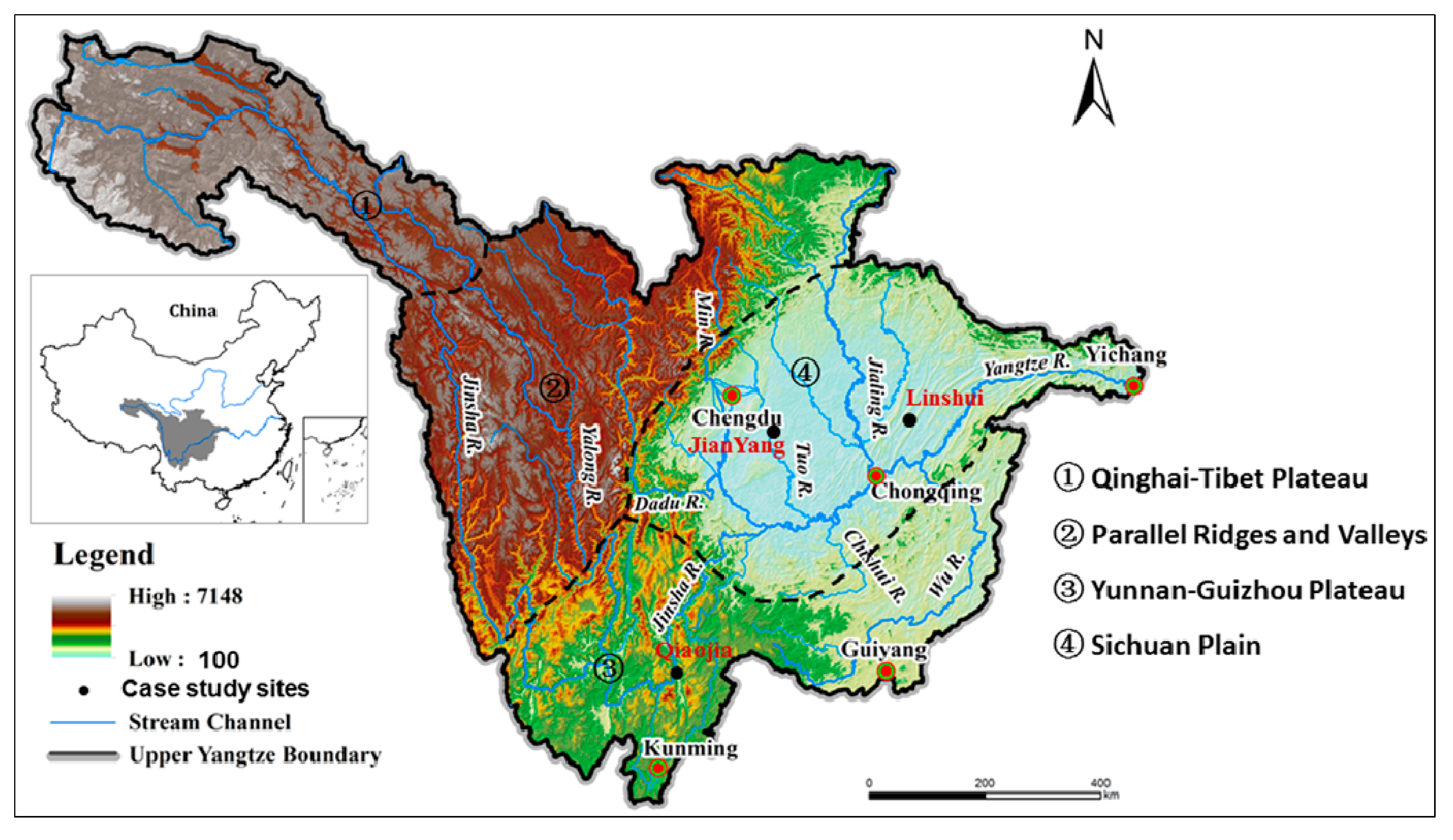
2. Site Description


| Study area | Precipitation (mm) | Slope gradient (°) | Slope length (m) | Soil erosion rates (t·km−2 year−1) |
|---|---|---|---|---|
| Tianshui (Gansu) | 606 | 19.3 | 20 | 4598 |
| 18 | 19 | 5310 | ||
| 12.8 | 34 | 2864 | ||
| 31 | 15 | 8216 | ||
| Zhenba (Sichuan) | 1250 | 10 | 27 | 7467 |
| 34 | 54 | 985 | ||
| 7 | 8 | 4200 | ||
| Nanchong (Sichuan) | 1010 | 11 | 17 | 4663 |
| 5 | 9 | 758 | ||
| 14 | 24.7 | 6780 | ||
| Kaixian (Chongqing) | 1090 | 25 | 10 | 9452 |
| 25 | 5 | 7481 | ||
| 25 | 8 | 9854 | ||
| Zigui (Chongqing) | 1048 | 31 | 29 | 2059 |
| Muding (Yunnan) | 851 | 20 | 13 | 6271 |
| Yiliang (Yunnan) | 917 | 25 | 21 | 8543 |
| Yuanmou (Yunnan) | 614 | 15 | 25 | 2740 |
| 5 | 70 | 1405 |
3. Materials and Methods
4. Results and Discussion
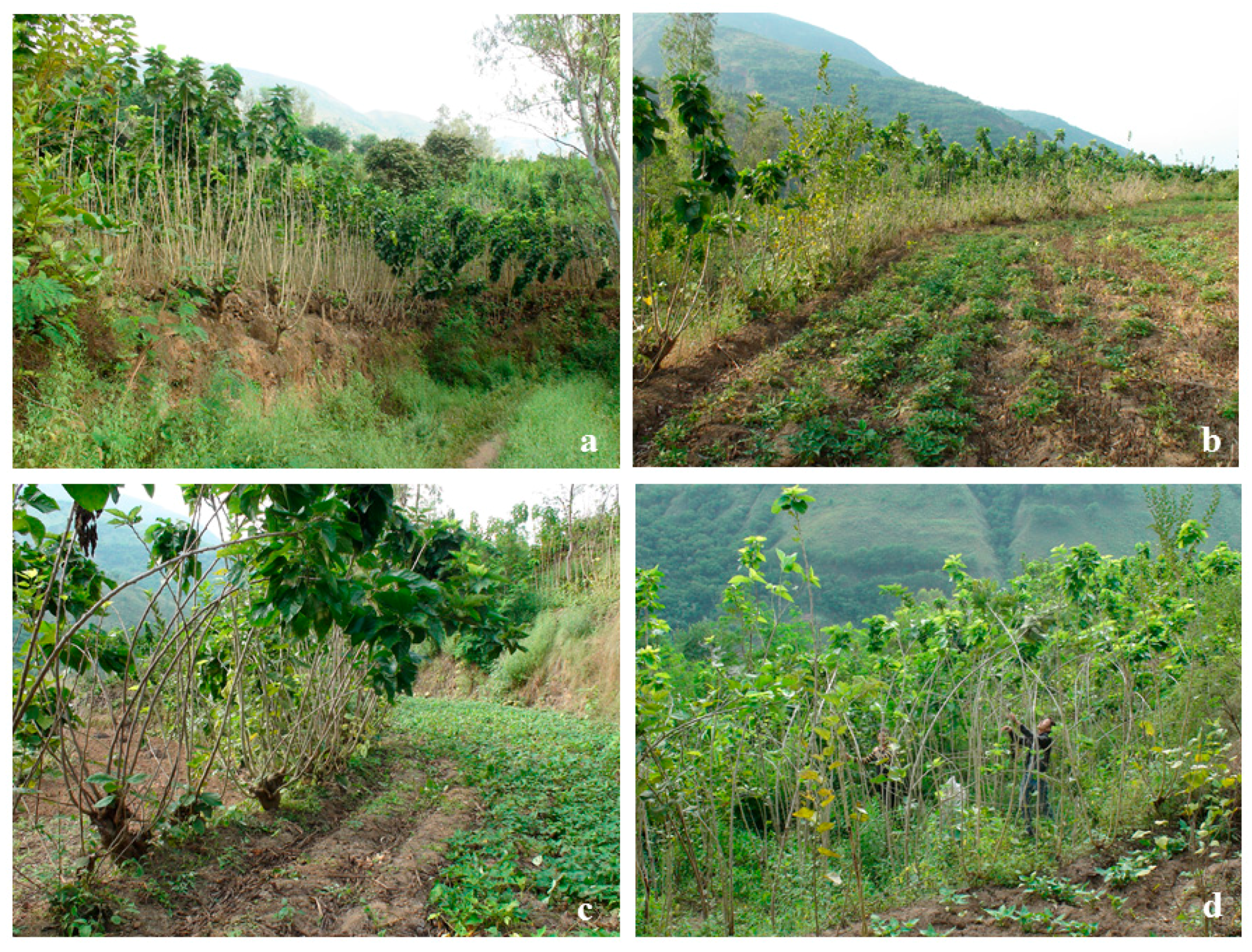
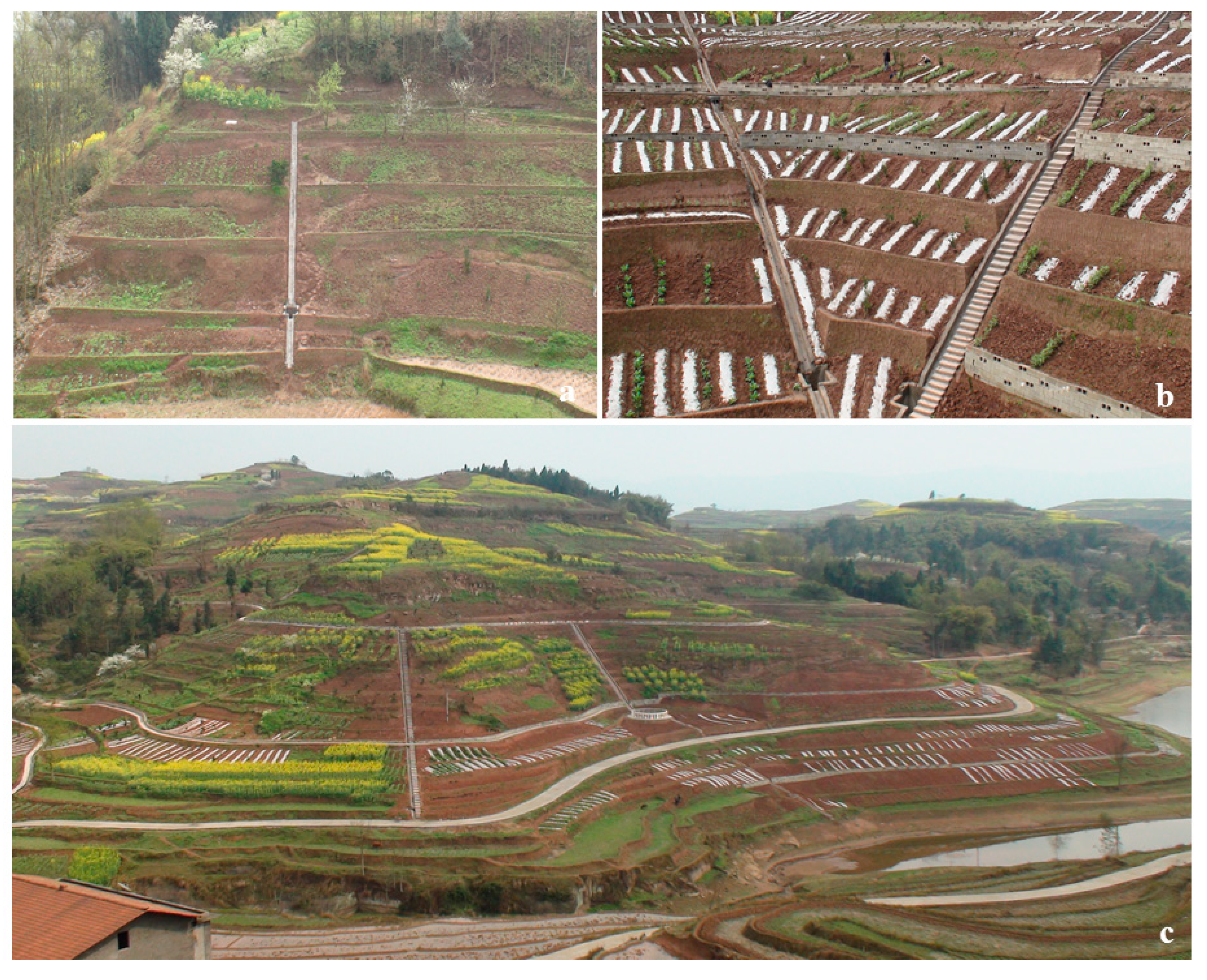
4.1. Marginal Hedgerows and Contour Buffering Strips


| Measures | Input | Runoff regulation | Soil loss | Agricultural output |
|---|---|---|---|---|
| Terraces | 2.4 Yuan/m2 | −72%~−79% | −88%~−93% | +52%~+86% |
| Hedgerow buffers a | 0.5 Yuan/m2 | −22%~−43% | −94%~−98% | +33%~+56% |
| Level trenches | 0.8 Yuan/m2 | −8%~−47% | −7%~−80% | +3%~+26% |
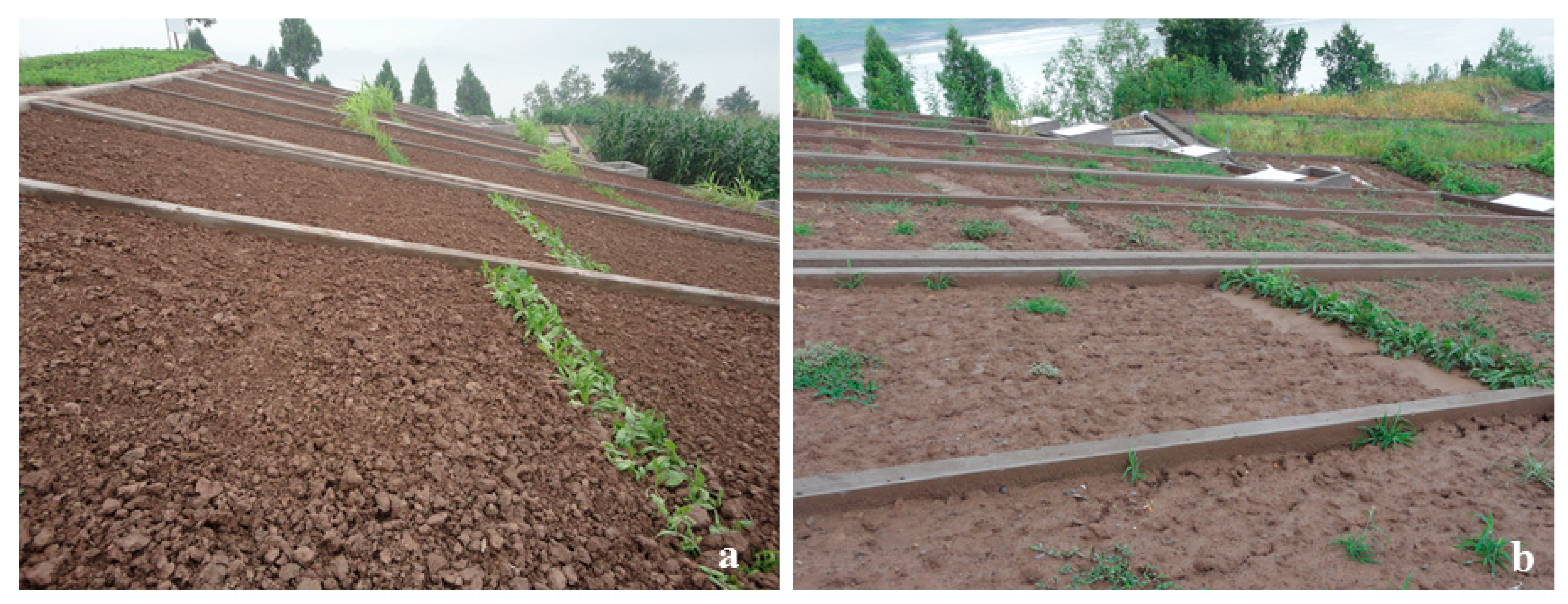
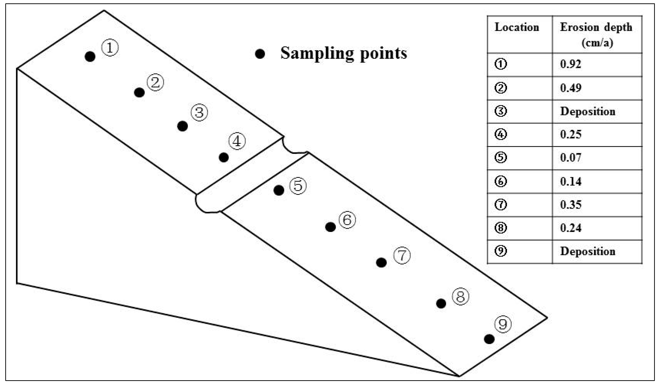
4.2. Sediment Retaining Trenches
| Slope gradient (°) | 5 | 15 | 20 | 25 | Study area | References |
|---|---|---|---|---|---|---|
| Critical length (m) | 6.13 | 4.12 | 2.72 | 1.55 | Zhong | Yang et al. 2010 [15] |
| 6.25 | 4.19 | 2.77 | 1.60 | Yanting | Yang et al. 2010 [16] |


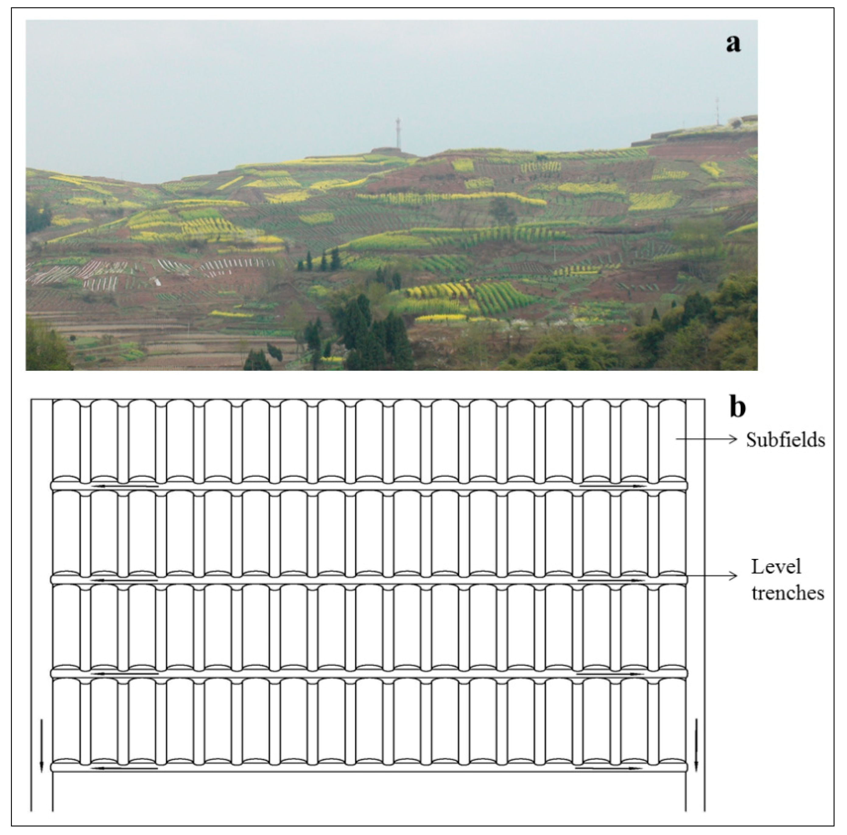
4.3. Sloping Terraces

4.4. Limited Downslope Tillage
| Conventional tillage | |||
|---|---|---|---|
| Translocation distance (m) | Tillage depth (m) | Translocation rate (kg·m−1 tillage·pass−1) | Erosion rate (Mg·ha−1 tillage·pass−1)· |
| 0.3268 | 0.17 | 77.87 | 77.87 |
| Conservation tillage | |||
| Translocation distance (m) | Tillage depth (m) | Translocation rate (kg·m−1 tillage·pass−1) | Erosion rate (Mg·ha−1 tillage·pass−1)· |
| 0.1105 | 0.19 | 28.44 | 28.44 |
5. Conclusions
Acknowledgments
Author Contributions
Conflicts of Interest
References
- Syvitski, J.P.M.; Vorosmarty, C.J.; Kettner, A.J.; Green, P. Impact of humans on the flux of terrestrial sediment to the global coastal ocean. Science 2005, 308, 376–380. [Google Scholar] [CrossRef] [PubMed]
- Walling, D.E. Human impact on land–ocean sediment transfer by the world’s rivers. Geomorphology 2006, 79, 192–216. [Google Scholar] [CrossRef]
- Jefferson, A.J.; Wegmann, K.W.; Chin, A. Geomorphology of the Anthropocene: Understanding the surficial legacy of past and present human activities. Anthropocene 2013, 2, 1–3. [Google Scholar] [CrossRef]
- Quinton, J.N.; Govers, G.; van Oost, K.; Bardgett, R.D. The impact of agricultural soil erosion on biogeochemical cycling. Nat. Geosci. 2010, 3, 311–314. [Google Scholar] [CrossRef] [Green Version]
- Wilkinson, B.H.; McElroy, B.J. The impact of humans on continental erosion and sedimentation. Geol. Soc. Am. Bull. 2007, 119, 140–156. [Google Scholar] [CrossRef]
- Dotterweich, M. The history of human-induced soil erosion: Geomorphic legacies, early descriptions and research, and the development of soil conservation—A global synopsis. Geomorphology 2013, 201, 1–34. [Google Scholar] [CrossRef]
- Dai, D.Z.; Tan, Y. Soil erosion and sediment yield in the Upper Yangtze River basin. In Erosion and Sediment Yield: Global and Regional Perspectives; Walling, D.E., Webb, B.W., Eds.; IAHS Press: Wallingford, UK, 1996; pp. 191–203. [Google Scholar]
- Meng, Q.H.; Fu, B.J.; Yang, L.Z. Effects of land use on soil erosion and nutrient loss in the Three Gorges Reservoir Area, China. Soil Use Manag. 2001, 17, 288–291. [Google Scholar] [CrossRef]
- Shi, Z.H.; Cai, C.F.; Ding, S.W.; Wang, T.W.; Chow, T.L. Soil conservation planning at the small watershed level using RUSLE with GIS: A case study in the Three Gorge Area of China. Catena 2004, 55, 33–48. [Google Scholar] [CrossRef]
- He, X.B.; Bao, Y.H.; Nan, H.W.; Xiong, D.H.; Wang, L.; Liu, Y.F.; Zhao, J.B. Tillage pedogenesis of purple soils in southwestern China. J Mt. Sci. 2009, 6, 205–210. [Google Scholar] [CrossRef]
- Zhang, X.B.; Zhang, Y.Y.; Wen, A.B.; Feng, M.Y. Assessment of soil losses on cultivated land by using the Cs-137 technique in the Upper Yangtze River Basin of China. Soil Till. Res. 2003, 69, 99–106. [Google Scholar] [CrossRef]
- Zhang, X.B.; He, X.B. Achievement of slope farm land regulation in upper Yangtze River. Yangtze River 2010, 41, 21–23. (In Chinese) [Google Scholar]
- Collins, A.L.; Walling, D.E. Documenting catchment suspended sediment sources: Problems, approaches and prosects. Prog. Phys. Geogr. 2004, 28, 159–196. [Google Scholar] [CrossRef]
- Zhang, J.H.; Su, Z.A.; Nie, X.J. An investigation of soil translocation and erosion by conservation hoeing tillage on steep lands using a magnetic tracer. Soil Till. Res. 2009, 105, 177–183. [Google Scholar] [CrossRef]
- Yan, D.C.; Wen, A.B.; Shi, Z.L.; Ju, L.; He, X.B. Critical slope length of rill occured in purple soil slope cultivated land in Three Gorges Reservoir Area. J. Yangtze River Sci. Res. Inst. 2010, 27, 58–66. (In Chinese) [Google Scholar]
- Yan, D.C.; Wen, A.B.; Shi, Z.L.; Su, M.; He, X.B. Critical slope length and control of roll occurence on cultivated land of purple soil in Scihuan Basin. Res. Soil Water Conservat. 2010, 17, 1–4. (In Chinese) [Google Scholar]
- Li, Q.Y.; Cai, Q.G.; Fang, H.Y.; Wang, C.C. Analyse of suitablity of soil and water conservation measures on sloping cultivated lands with different slopes over the purple soil region in the upper reaches of the Yangtze River. Resour. Sci. 2009, 31, 2157–2163. (In Chinese) [Google Scholar]
- Zhang, J.H.; Su, Z.A.; Liu, G.C. Effects of terracing and agroforestry on soil and water loss in hilly areas of the Sichuan Basin, China. J Mt Sci. 2008, 5, 241–248. [Google Scholar] [CrossRef]
- Fang, N.F.; Shi, Z.H.; Yue, B.J.; Wang, L. The characteristics of extreme erosion events in a small mountainous watershed. PLoS One 2013, 8, e76610. [Google Scholar] [CrossRef] [PubMed]
- Li, L.Y.; Wang, Z.J.; Jiao, J.Y. Erosive rainfall and rainfall erosivity in purple hilly area. Sci. Soil Water Conservat. 2013, 11, 8–16. (In Chinese) [Google Scholar]
- Tu, S.H.; Chen, Y.B.; Zhu, Q.; Guo, Y.Z.; Zhu, Z.L. Role and effect of cash crop hedgerows on controlling soil and water losses from sloping farmlands in the Upper Reaches of Yangtze River. J. Soil Water Conservat. 2005, 19, 1–5. (In Chinese) [Google Scholar]
- Xu, F.; Cai, Q.G.; Wu, S.A.; Zhang, G.Y.; Caoi, C.F.; Ding, S.W.; Shi, Z.H.; Huang, L. Characteristics of erosion control by contour hesgerows on cultivated slope land of purple soil. Acta Pedol. Sin. 2002, 39, 71–80. (In Chinese) [Google Scholar]
- Chen, Y.; He, B.H.; Xiang, M.H.; Chen, J.J. Effect of hedgerow on soil and water conservation in sloping cropland of the purple soil. J Soil Water Conservat. 2013, 27, 47–52. (In Chinese) [Google Scholar]
- Ma, Y.; He, B.H.; He, J.L.; Wu, Y.; Xiang, M.H.; Chen, Y.; Tang, C.X.; Guo, T. Conformation of critical distance between hedgerows for non-point poluution control based on hydro-dynamics in purple soil area. Trans. Chin. Soc. Agric. Eng. 2011, 27, 60–64. (In Chinese) [Google Scholar]
- Ng, S.L.; Cai, Q.G.; Ding, S.W.; Chau, K.C.; Qin, J. Effects of contour hedgerows on water and soil conservation, crop productivity nad nutrient bydget for slope farmland in the Three Gorges Region (TGR) of China. Agroforest. Syst. 2008, 74, 279–291. [Google Scholar] [CrossRef]
- Shi, L.R. Hillside field improvement of Yangtze valley. Yangtze Rive 1999, 30, 25–28. (In Chinese) [Google Scholar]
- He, X.B.; Xu, Y.B.; Zhang, X.B. Traditional farming system for soil conservation on slope farmland in southwestern China. Soil Till. Res. 2007, 94, 193–200. [Google Scholar] [CrossRef]
- Quine, T.A.; Walling, D.E.; Chakela, Q.K.; Mandiringana, O.T.; Zhang, X. Rates and patterns of tillage and water erosion on terraces and contour strips: Evidence from caesium-137 measurements. Catena 1999, 36, 115–142. [Google Scholar] [CrossRef]
- De Alba, S.; Lindstrom, M.; Schumacher, T.E.; Malo, D.D. Soil landscape evolution due to soil redistribution by tillage: A new conceptual model of soil catena evolution in agricultural landscapes. Catena 2004, 58, 77–100. [Google Scholar] [CrossRef]
- Zhang, J.H.; Lobb, D.A.; Li, Y.; Liu, G.C. Assessment of tillage translocation and tillage erosion by hoeing on the steep land in hilly areas of Sichuan, China. Soil Till. Res. 2004, 75, 99–107. [Google Scholar] [CrossRef]
- De Alba, S. Modeling the effects of complex topography and patterns of tillage on soil translocation by tillage with mouldboard plough. J. Soil Water Conservat. 2001, 56, 335–345. [Google Scholar]
- Zhang, J.H.; Nie, X.J.; Su, Z.A. Soil Profile Properties in Relation to Soil Redistribution by Intense Tillage on a Steep Hillslope. Soil Sci. Soc. Am. J. 2008, 72, 1767–1773. [Google Scholar] [CrossRef]
- Zhang, J.H.; Ni, S.J.; Su, Z.A. Dual roles of tillage erosion in lateral SOC movement in the landscape. Eur. J. Soil Sci. 2012, 63, 165–176. [Google Scholar] [CrossRef]
- Zhang, J.H.; Quine, T.A.; Ni, S.J.; Ge, F.L. Stocks and dynamics of SOC in relation to soil redistribution by water and tillage erosion. Global Change Biol. 2006, 12, 1834–1841. [Google Scholar] [CrossRef]
© 2014 by the authors; licensee MDPI, Basel, Switzerland. This article is an open access article distributed under the terms and conditions of the Creative Commons Attribution license (http://creativecommons.org/licenses/by/3.0/).
Share and Cite
Tang, Q.; He, C.; He, X.; Bao, Y.; Zhong, R.; Wen, A. Farmers’ Sustainable Strategies for Soil Conservation on Sloping Arable Lands in the Upper Yangtze River Basin, China. Sustainability 2014, 6, 4795-4806. https://doi.org/10.3390/su6084795
Tang Q, He C, He X, Bao Y, Zhong R, Wen A. Farmers’ Sustainable Strategies for Soil Conservation on Sloping Arable Lands in the Upper Yangtze River Basin, China. Sustainability. 2014; 6(8):4795-4806. https://doi.org/10.3390/su6084795
Chicago/Turabian StyleTang, Qiang, Chansheng He, Xiubin He, Yuhai Bao, Ronghua Zhong, and Anbang Wen. 2014. "Farmers’ Sustainable Strategies for Soil Conservation on Sloping Arable Lands in the Upper Yangtze River Basin, China" Sustainability 6, no. 8: 4795-4806. https://doi.org/10.3390/su6084795