
On the Relationship between Holocene Geomorphic Evolution of Rivers and Prehistoric Settlements Distribution in the Songshan Mountain Region of China

Abstract
:1. Introduction
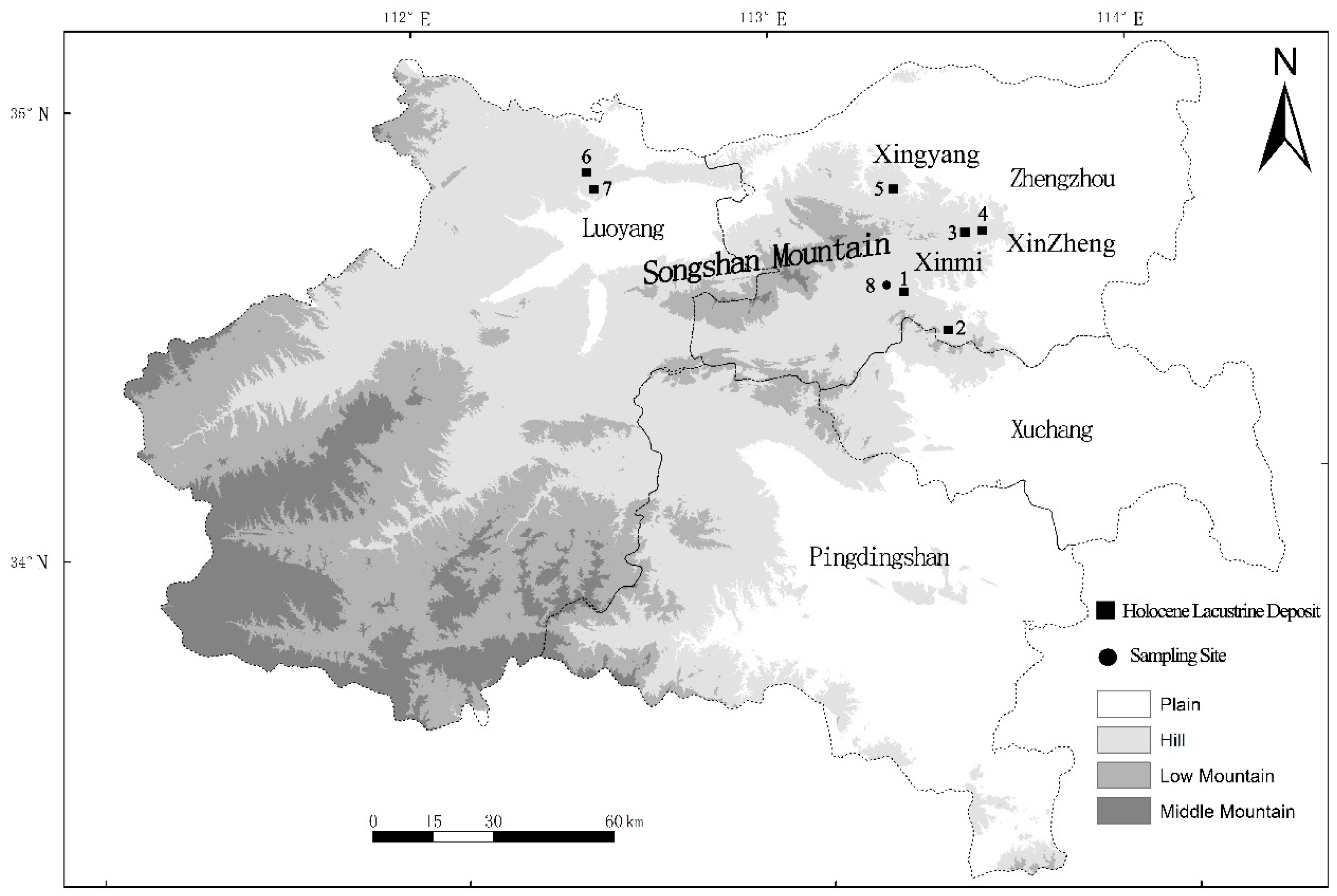
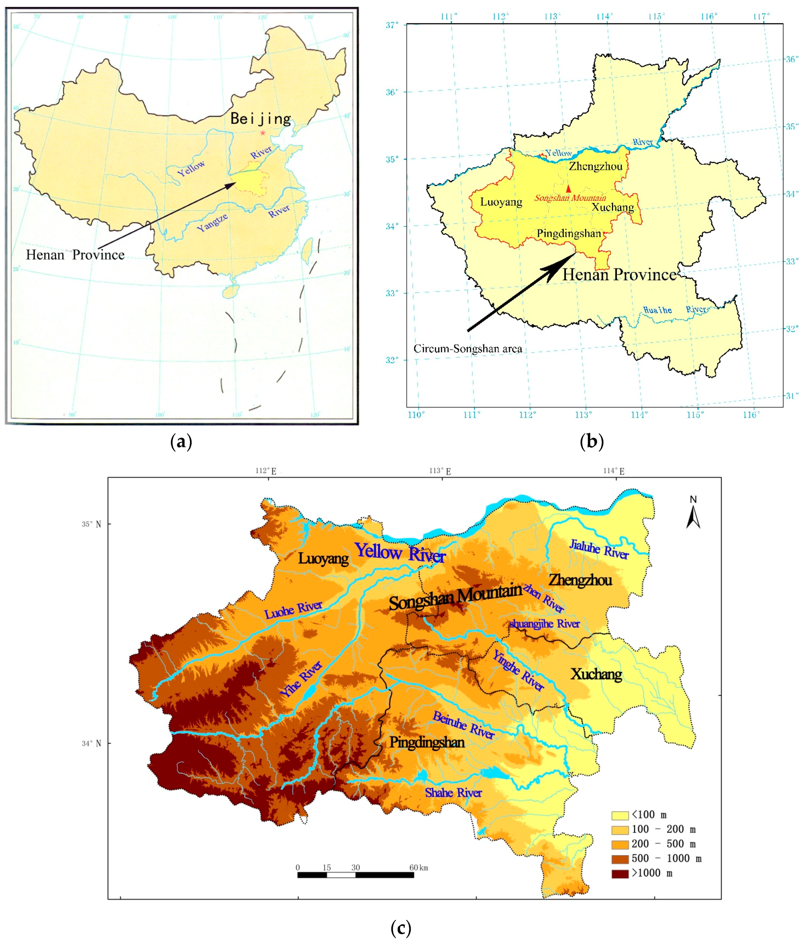
2. Research Area
3. Data and Methods
3.1. Data
3.2. Field Survey
3.3. Experimental Analysis
3.4. Acquisition of Data on Elevation of Settlements above River Level
3.5. Revision of Elevation above River Level
3.6. Statistical Analysis of Elevation above the River Level
4. Results and Discussion
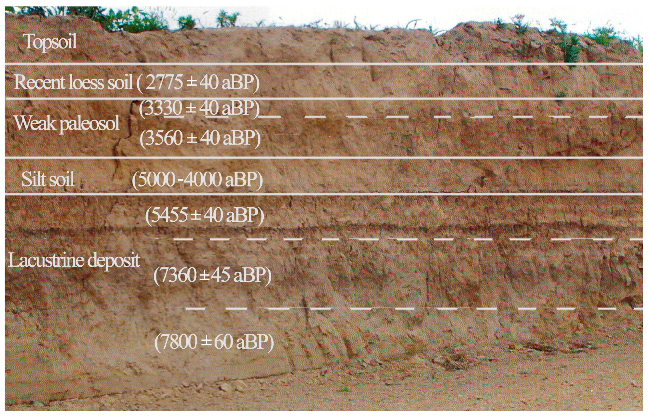
4.1. Evolutionary Features of Holocene Fluvial Landforms
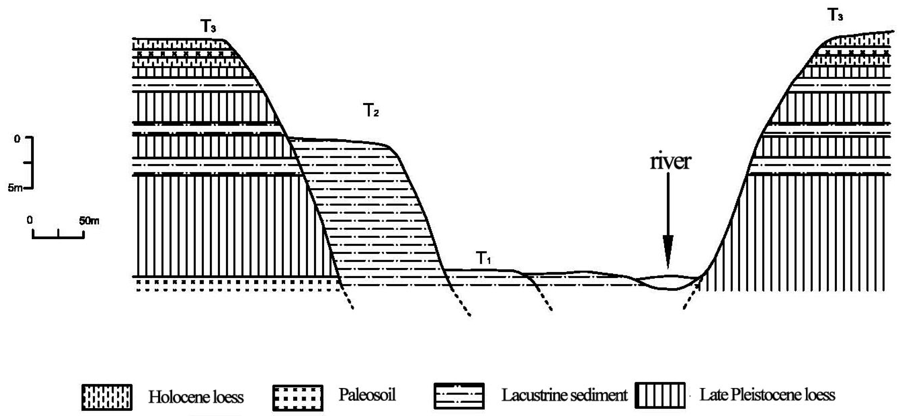
- (1)
- Topsoil at 0.3 m characterized as tilled soil, loose texture, with large porosity and severe artificial disturbance.
- (2)
- Recent loess soil at 0.4 m characterized as sandy loess, grayish yellow, uniform and loose texture, with a small amount of mycelia at the bottom (the bottom was dated by AMS 14C as 2775 ± 40 aBP).
- (3)
- Weak palaeosol at 0.6 m with two sublayers. Upper sublayer: 0.2 m, brown, containing a large amount of argillan and mycelia, and having dense texture (dated by AMS 14C as 3330 ± 40 aBP). Lower sublayer: 0.4 m, maroon, dense and hard texture, with a large amount of mycelia and argillan (dated by AMS 14C as 3560 ± 40 aBP, corresponding to the Xiashang Period).
- (4)
- Silt soil at 0.5 m characterized as grayish yellow, with obvious horizontal bedding, soft texture, but no dating. Its age was estimated by the dating data and sedimentation rate of the upper and lower layers at approximately 5000–4000 aBP, corresponding to the Longshan Period.
- (5)
- Lacustrine deposit at 2.8 m outcrop. In the south, this is the layer corresponding to the Yangshao settlement. Both the lacustrine deposit and the layer of the Yangshao settlement are overlain by silt soil. This layer is subdivided into three sublayers. Upper sublayer: 0.5 m, lacustrine deposit, clay, gray green, dated by AMS 14C as 5455 ± 40 aBP. Intermediate sublayer: 0.8 m, alternating lacustrine deposit and secondary loess, clayey silt, light gray green, dated by AMS 14C as 7360 ± 45 aBP. Lower sublayer: 1.5 m, lacustrine deposit, clay, deep gray green, dated by AMS 14C as 7800 ± 60 aBP.
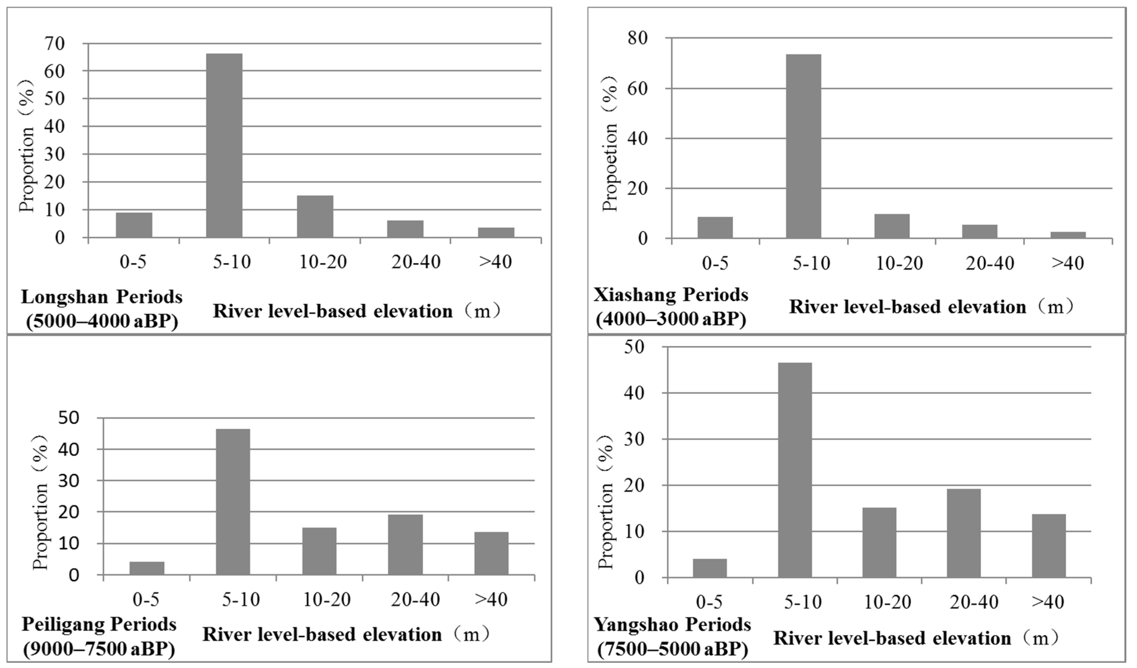
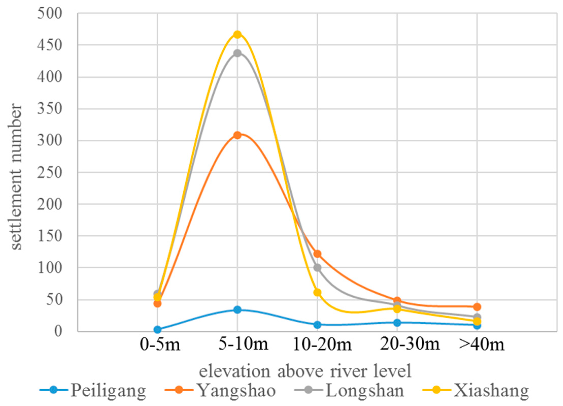
4.2. Elevation of Prehistoric Settlements above River Level
4.3. Discussion
5. Conclusions
- (1)
- The features of fluvial landforms in the early and middle Holocene in the Songshan Mountain area were much different from today. In the middle Holocene (8500–3000 aBP), the Songshan Mountain area experienced large-scale sedimentation, with river levels generally higher than today’s levels. In the late Holocene (after 3000 aBP), the mountainous region and hilly lands in the upper and middle reaches began to experience river downcutting, while the lower reaches experienced continuous sedimentation.
- (2)
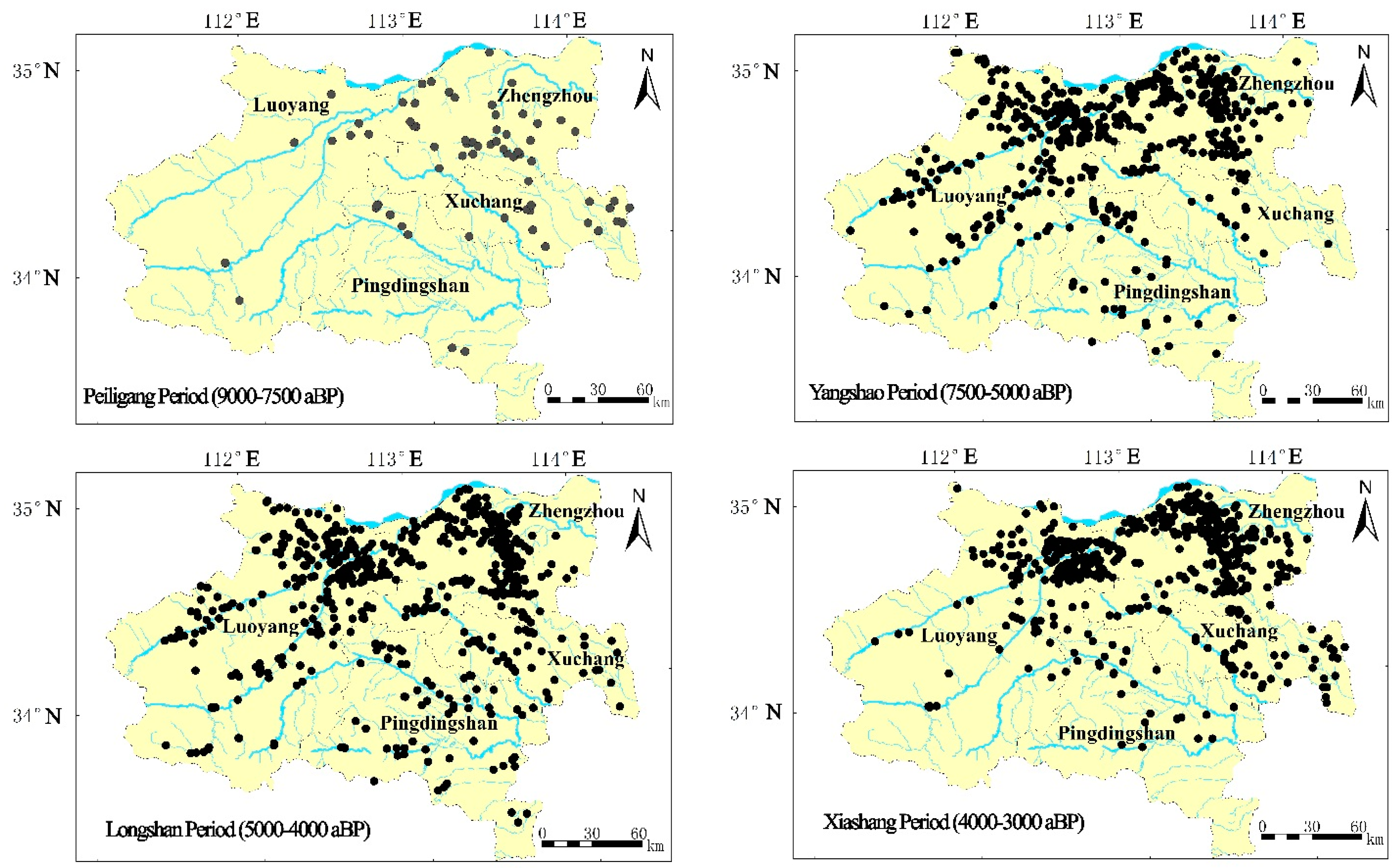
- Selection of prehistoric settlement sites in the Songshan Mountain area evolved over time. In the Peiligang period, settlements were constructed in both the elevated terrain (mountainous region and hilly lands) and on the plain, depending on the production mode. In the Yangshao and Longshan periods, settlements were mainly distributed in the mountainous region and hilly lands. In the Xiashang period, the percentage of settlements established on the plain tended to increase respect to the past periods.
- (3)
- The low hills and hilly lands with elevations above river levels of 5–20 m consistently had the largest number and highest density of prehistoric settlements in the Songshan Mountain area. The long-term, effective utilization of low hills and hilly lands that were widely distributed with flat tops and a loess layer insured the continuity of local culture for thousands of years.
- (4)
- Study of the distribution of prehistoric settlements and the evolution of fluvial landforms indicates that the environment plays a fundamental role in interactions between prehistoric humans and nature. In the process, human beings always selected the land with the most appropriate natural conditions to live according to their own cultural features.
- (5)
Acknowledgments
Author Contributions
Conflicts of Interest
References
- Trigger, B.G. Time and Tradition: Essays in Archeological Interpretation; Edinburgh University Press: Edinburgh, UK, 1978. [Google Scholar]
- Chang, K.C. Settlement Archaeology; National Press Books: Palo Alto, CA, USA, 1968. [Google Scholar]
- Russell Stafford, C.; Creasman, S.D. The hidden record: Late Holocene landscapes and settlement archaeology in the Lower Ohio River Valley. Geoarchaeology 2002, 17, 117–140. [Google Scholar] [CrossRef]
- Hu, K.; Mo, D.W.; Mao, L.J.; Li, S.C.; Wang, H.; Cao, W.; Zhang, Y.F. Spatial analysis and landscape significance of mankind settlement sites in Wuding River Basin in Mid-Holocene. Sci. Geogr. Sin. 2011, 31, 415–420. (In Chinese) [Google Scholar]
- Lu, P. Review on prehistoric settlement geography research. Prog. Geogr. 2013, 32, 1286–1295. (In Chinese) [Google Scholar]
- Potter, T.W. Valleys and Settlement: Some New Evidence. World Archaeol. 2003, 8, 207–219. [Google Scholar] [CrossRef]
- Yan, L.J.; Shi, Y.S.; Yang, R.X.; Lu, P. Prehistoric settlement sites selection preference zoning around Songshan Area. J. Tongji Univ. (Nat. Sci.) 2013, 41, 624–629. (In Chinese) [Google Scholar]
- Yang, R.X.; Lu, P.; Wu, H.H. The analysis of spacial centralized character of settlements at Peiligang Culture Period in Henan Province. Areal Res. Dev. 2012, 31, 150–155. (In Chinese) [Google Scholar]
- East, A.E.; Collins, B.D.; Sankey, J.B.; Corbett, S.C.; Fairley, H.C.; Caster, J. Conditions and Processes Affecting Sand Resources at Archaeological Sites in the Colorado River Corridor Below Glen Canyon Dam, Arizona; US Geological Survey Professional Paper 1825; U.S. Geological Survey: Reston, VA, USA, 2016; p. 104.
- Balsom, J.R.; Ellis, J.G.; Horn, A.; Leap, L.M. Using cultural resources as part of the plan—Grand Canyon management and implications for resource preservation. In The Colorado Plateau II—Biophysical, Socioeconomic, and Cultural Research: Tucson; van Riper, C., III, Mattson, D.J., Eds.; University of Arizona Press: Tucson, AZ, USA, 2005; pp. 367–377. [Google Scholar]
- Fairley, H.C. Cultural resources in the Colorado River corridor. In The State of the Colorado River Ecosystem in Grand Canyon; Gloss, S.P., Lovich, J.E., Melis, T.S., Eds.; U.S. Geological Survey Circular 1282; Grand Canyon Monitoring and Research Center: Flagstaff, AZ, USA, 2005; pp. 177–192. [Google Scholar]
- Davis, W.M. The geographical cycle. Geogr. J. 1899, 14, 481–504. [Google Scholar] [CrossRef]
- Yang, J.C.; Li, Y.L. Principle of Geomorphology; Peking University Press: Beijing, China, 2001. (In Chinese) [Google Scholar]
- Lu, P.; Yang, R.X. Summarizing the prehistoric settlement in the digital environment archaeology. Areal Res. Dev. 2013, 32, 165–169. (In Chinese) [Google Scholar]
- Danese, M.; Masini, N.; Biscione, M.; Lasaponara, R. Predictive modeling for preventive Archaeology: Overview and case study. Cent. Eur. J. Geosci. 2014, 6, 42–55. [Google Scholar] [CrossRef]
- Zhang, D.S. The characteristics of civilization origin in Central China. Huaxia Archaeol. 2002, 4, 48–53. (In Chinese) [Google Scholar]
- Zhou, K.S. Environmental Archaeology; Cultural Relics Publishing House: Beijing, China, 2007. (In Chinese) [Google Scholar]
- Zhou, K.S.; Zhang, S.L.; Zhang, Z.Y.; Yang, R.X.; Cai, Q.F.; Song, G.D.; Song, Y.Q.; Mo, D.W.; Wang, H.; Lu, P.; et al. Songshan Cultural Circle. Cult. Relics Cent. China 2005, 5, 12–20. (In Chinese) [Google Scholar]
- Wang, W.K. Henan Geography; Henan People’s Publishing House: Zhengzhou, China, 1990. (In Chinese) [Google Scholar]
- Huang, C.C.; Pang, J.L.; Zha, X.C.; Su, H.X.; Jia, Y.F. Extraordinary floods related to the climatic event at 4200 aBP on the Qishuihe River, middle reaches of the Yellow River, China. Quat. Sci. Rev. 2011, 30, 460–468. [Google Scholar] [CrossRef]
- Shi, Z.M. The Natural Conditions and Resources of Henan Province; Science and Technology Press: Zhengzhou, China, 1986. (In Chinese) [Google Scholar]
- Institute of Archaeology, Chinese Academy of Social Sciences. Chinese Archaeology (Xia and Shang Volume); China Social Sciences Publishing House: Beijing, China, 2003. (In Chinese) [Google Scholar]
- Institute of Archaeology, Chinese Academy of Social Sciences. Chinese Archaeology (Neolithic Volume); China Social Sciences Publishing House: Beijing, China, 2010. (In Chinese) [Google Scholar]
- Henan Bureau of Geology and Mineral Resources. Areal Geology of Henan Province; Geological Publishing House: Beijing, China, 1989. (In Chinese)
- Lu, P.; Tian, Y.; Chen, P.P.; Mo, D.W. Spatial and temporal modes of prehistoric settlement distribution around Songshan Mountain. Acta Geogr. Sin. 2016, 71, 1629–1639. (In Chinese) [Google Scholar]
- Henan Province Administration of Cultural Heritage. Cultural Heritage Chronicles of Henan Province; Cultural Relics Press: Beijing, China, 2009. (In Chinese)
- Zhou, K.S.; Zhang, S.L.; Mo, D.W.; Wang, H. Environment and culture during the latest middle Pleistocene-early late Pleistocene in the Mountain Song region, Henan Province. Quat. Sci. 2006, 26, 543–547. (In Chinese) [Google Scholar]
- Xu, J.J.; Mo, D.W.; Wang, H.; Zhou, K.S. Preliminary research of environment archaeology in Zhenshui River, Xinmi City, Henan. Quat. Sci. 2013, 33, 981–991. (In Chinese) [Google Scholar]
- Chengdu Geology College. Sedimentary Rock Particle Size Analysis and Its Application; Geological Publishing House: Beijing, China, 1978. (In Chinese) [Google Scholar]
- Wang, H. Exploration of the relationship between neolithic settlement distribution and natural environment in the middle-upper Shuangjihe River. In Science and Technology Archaeology (Album 2); Archaeological Center of Science and Technology, Institute of Archaeology, Chinese Academy of Social Sciences, Ed.; Science Press: Beijing, China, 2007; pp. 141–154. (In Chinese) [Google Scholar]
- Dong, G.H.; Xia, Z.K.; Liu, D.C.; Wu, Q.L. Environmental change and its impact on human activities in Middle Holocene at Mengjin, Henan Province. Acta Sci. Nat. Univ. Pekin. 2006, 42, 238–243. (In Chinese) [Google Scholar]
- Sun, X.W.; Xia, Z.K. Paleoenvironment Changes since Mid-Holocene Revealed by a Palynological Sequence from Sihenan Profile in Luoyang, Henan Province. Acta Sci. Nat. Univ. Pekin. 2005, 41, 289–298. (In Chinese) [Google Scholar]
- Wang, D.F.; Wang, C.; Wang, C.D.; Guo, Y.S. Lake Yuxingze, a natural flood detention area of the Yellow River in ancient time. J. Lake Sci. 2012, 24, 320–326. (In Chinese) [Google Scholar]
- Xia, Z.K.; Wang, Z.H.; Zhao, C.Q. Extreme flood events and climate change around 3500 aBP in the Central Plains of China. Sci. China Ser. D Earth Sci. 2004, 47, 599–606. [Google Scholar] [CrossRef]
- Wang, H.; Zhang, H.; Zhang, J.F.; Fang, Y.M. The fluvial geomorphology evolution and some relevant question of Wadian Site in Yuzhou City, Henan Province. South. Cult. Relics 2015, 4, 67–77. (In Chinese) [Google Scholar]
- Wan, Y.; Liu, Y.; Shi, Z.T. Structure and characteristics of geomorphology in the area between Huanghe River and Luohe River in Henan Province. J. Lanzhou Univ. (Nat. Sci.) 2010, 46, 40–47. (In Chinese) [Google Scholar]
- Yan, F.H.; Mai, X.S.; Ye, Y.Y. Geological ace and environment of the Dahecun Site, Zhengzhou, from sporo-poilen data. Seismol. Geol. 1986, 8, 69–74. (In Chinese) [Google Scholar]
- Dillehay, T.D. Climate and human migrations. Science 2002, 298, 764–765. [Google Scholar] [CrossRef] [PubMed]
- Howard, A.J.; Brown, A.G.; Carey, C.J.; Challis, K. Archaeological resource modeling intemperate river valleys: A case study from the Trent Valley, UK. Antiquity 2008, 82, 1040–1054. [Google Scholar] [CrossRef]
- Nunez, L.; Grosjean, M.; Cartajena, I. Human occupations and climate change in the Puna de Atacama, Chile. Science 2002, 298, 821–824. [Google Scholar] [CrossRef] [PubMed]
- Tristram, R.K.; Katherine, A.A.; Lee, J.; Schilling, T.M. Basin scale reconstruction of the geological context of human settlement: An example from the lower Mississippi Valley, USA. Quat. Sci. Rev. 2008, 27, 1255–1270. [Google Scholar]
- Walker, I.J.; Desloges, J.R.; Crawford, G.W.; Smith, D.G. Floodplain formation processes and archaeological implications at the Grand Banks Site, lower Grand River, Southern, Ontario. Geoarchaeology 1997, 12, 865–887. [Google Scholar] [CrossRef]
- Wilkinson, T.J. Water and human settlement in the Balikh Valley, Syria: Investigations from 1992–1995. J. Field Archaeol. 1998, 25, 63–87. [Google Scholar] [CrossRef]
- Lu, P.; Tian, Y.; Chen, P.P.; Yan, L.J.; Song, L.S. The relationship between settlements distribution and regional tectonics around the Songshan Mountain during 9000–3000 aBP. Acta Geogr. Sin. 2014, 69, 738–746. (In Chinese) [Google Scholar]
- Lu, P.; Tian, Y.; Yang, R.X. The study of size-grade of prehistoric settlement in the Circum-Songshan area based on SOFM network. J. Geogr. Sci. 2013, 23, 538–548. [Google Scholar] [CrossRef]
- Lu, P.; Tian, Y. The successive mode of 9000–3000 aB.P. settlements and its relationship with the terrain around Songshan Mountain. Quat. Sci. 2013, 33, 965–971. (In Chinese) [Google Scholar]
- Liu, L.; Lee, G.A.; Jiang, L.P.; Zhang, J. Evidence for the early beginning (c. 9000cal. BP) of rice domestication in China: A response. Holocene 2007, 17, 1059–1068. [Google Scholar] [CrossRef]
- Zhao, Z.J. Plant archaeology research about agriculture origin and civilization origin. Manag. Rev. Soc. Sci. 2005, 2, 82–91. (In Chinese) [Google Scholar]
- Institute of Archaeology, Chinese Academy of Social Sciences. The Shawoli Neolith Site in Xinzheng, Henan. Archaeology 1983, 12, 1057–1065. (In Chinese) [Google Scholar]
- Wang, H.J. The carbonization grain was found in Shawoli Site, Xinzheng. Agric. Archaeol. 1984, 2, 276–277. (In Chinese) [Google Scholar]
- Zhang, Y.H.; Weng, Y.; Yao, L.; Zhang, J.Z.; Zhou, M.J.; Fang, F.; Cui, W. Identification and analysis of starch granules on the surface of the slabs from Peiligang Site. Quat. Sci. 2011, 31, 891–899. (In Chinese) [Google Scholar]
- Xu, T.S. The original agriculture during the Peiligang Period. Cult. Relics Cent. China 1998, 3, 12–23. (In Chinese) [Google Scholar]
- Lasaponara, R.; Leucci, G.; Masini, N.; Persico, R.; Scardozzi, G. Towards an operative use of remote sensing for exploring the past using satellite data: The case study of Hierapolis (Turkey). Remote Sens. Environ. 2016, 174, 148–164. [Google Scholar] [CrossRef]
- Lasaponara, R.; Masini, N. Satellite Synthetic Aperture Radar in Archaeology and Cultural Landscape: An Overview. Archaeol. Prospect. 2013, 20, 71–78. [Google Scholar] [CrossRef]
- Lu, P.; Yang, R.; Guo, Y.; Chen, F.; Masini, N.; Lasaponara, R. On the use of historical archive of aerial photographs for the discovery and interpretation of ancient hidden linear cultural relics in the alluvial plain of eastern Henan, China. J. Cult. Herit. 2016. [Google Scholar] [CrossRef]


| Layer | Sublayer | Age (aBP) | Mz (φ) | S0 | σ1 | Sk1 | KG |
|---|---|---|---|---|---|---|---|
| Recent loess | 2775 ± 40 | 4.87 | 4.94 | 1.65 | 0.24 | 0.95 | |
| Weak palaeosol | Upper sublayer | 3330 ± 40 | 4.56 | 4.77 | 1.65 | 0.38 | 0.97 |
| Lower sublayer | 3560 ± 40 | 4.47 | 2.99 | 1.41 | 0.37 | 1.30 | |
| Silt soil | 5000–4000 | 4.04 | 2.51 | 1.22 | 0.33 | 1.48 | |
| Lacustrine deposit | Upper sublayer | 5455 ± 40 | 5.51 | 3.51 | 1.39 | 0.18 | 1.09 |
| Intermediate sublayer | 7360 ± 45 | 5.39 | 4.75 | 1.59 | 0.13 | 0.94 | |
| Lower sublayer | 7800 ± 60 | 4.99 | 5.33 | 1.71 | 0.15 | 0.94 |
| Settlements in Hilly Lands and Mountainous Region (200–1000 m) | Settlements on the Plain (<200 m) | Total | |||
|---|---|---|---|---|---|
| Number | Proportion | Number | Proportion | ||
| Peiligang | 61 | 84% | 12 | 16% | 73 |
| Yangshao | 527 | 94% | 36 | 6% | 563 |
| Longshan | 632 | 96% | 28 | 4% | 660 |
| Xiashang | 547 | 86% | 87 | 14% | 634 |
| Min (m) | Max (m) | Mean (m) | Quantitative Statistics | |||||
|---|---|---|---|---|---|---|---|---|
| 0–5 m | 5–10 m | 10–20 m | 20–40 m | >40 m | ||||
| Peiligang | 2 | 80 | 17 | 3 | 34 | 11 | 14 | 10 |
| 4.2% | 47.2% | 15.3% | 19.4% | 13.9% | ||||
| Yangshao | 2 | 350 | 14 | 44 | 309 | 122 | 49 | 39 |
| 7.8% | 54.9% | 21.7% | 8.7% | 6.9% | ||||
| Longshan | 2 | 350 | 10 | 59 | 437 | 100 | 41 | 23 |
| 8.9% | 66.2% | 15.2% | 6.2% | 3.5% | ||||
| Xiashang | 2 | 320 | 9 | 54 | 467 | 62 | 35 | 16 |
| 8.5% | 73.7% | 9.8% | 5.5% | 2.5% | ||||
© 2017 by the authors; licensee MDPI, Basel, Switzerland. This article is an open access article distributed under the terms and conditions of the Creative Commons Attribution (CC-BY) license (http://creativecommons.org/licenses/by/4.0/).
Share and Cite
Lu, P.; Mo, D.; Wang, H.; Yang, R.; Tian, Y.; Chen, P.; Lasaponara, R.; Masini, N. On the Relationship between Holocene Geomorphic Evolution of Rivers and Prehistoric Settlements Distribution in the Songshan Mountain Region of China. Sustainability 2017, 9, 114. https://doi.org/10.3390/su9010114
Lu P, Mo D, Wang H, Yang R, Tian Y, Chen P, Lasaponara R, Masini N. On the Relationship between Holocene Geomorphic Evolution of Rivers and Prehistoric Settlements Distribution in the Songshan Mountain Region of China. Sustainability. 2017; 9(1):114. https://doi.org/10.3390/su9010114
Chicago/Turabian StyleLu, Peng, Duowen Mo, Hui Wang, Ruixia Yang, Yan Tian, Panpan Chen, Rosa Lasaponara, and Nicola Masini. 2017. "On the Relationship between Holocene Geomorphic Evolution of Rivers and Prehistoric Settlements Distribution in the Songshan Mountain Region of China" Sustainability 9, no. 1: 114. https://doi.org/10.3390/su9010114