1. Introduction
Since the economic reform, China has developed a unique dual urban-rural land system [
1], in which the government distinguishes urban land owned by the state from rural land owned by village collectives. On state-owned land, land use rights can be sold, transferred, and leased in the urban land market, and a variety of development activities are permitted. On rural land, however, according to the Land Administration Law, regulations favor agricultural use, and development is strictly constrained to three major types, namely, residential plots for farmers, land used for public facilities, and land used for township or village enterprises. Large-scale development, such as real estate development and factory building, is illegal on rural land, except where the state has taken ownership of a parcel of land from a village collective, thus turning it into state-owned land [
2,
3].
In more than 30 years of rapid economic growth and urbanization, the number of cities has increased from 226 in 1981 to 656 in 2015. Meanwhile, the urban population and built-up areas of cities have expanded at an unprecedented rate, from 201.71 million people to 771.16 million people, and from 7438 km
2 to 52,102.3 km
2, respectively [
4,
5]. This has led to massive expansion of urban land, which has mostly occurred on what was previously rural land. Thus, land acquisition by the state from farmer collectives is required according to the law. However, a certain amount of illegal development has taken place on collective-owned land, especially in big metropolitan areas and eastern coastal areas, which have experienced major economic growth and population migration [
6]. For instance, in the Pearl River Delta region, it is estimated that more than 50% of the land development has occurred on collective-owned rural land [
7]. As a result, a gap has opened up between the law’s requirement and de facto development.
It is believed that clearly defined property rights play a critical role in the market economy in dealing with conflicts that arise with the use of scarce resources [
8]. Property rights are defined as a bundle of rights attached to a physical commodity or service, and they convey the right to make a profit or loss on transactions [
9]. Property rights in relation to land mean possession of a recognizable, fungible bundle of rights, which the owner can own, use, sell, trade, lease, and bequeath [
10]. The allocation of land property rights has far-reaching effects on other social outcomes, with the connection between land property rights and economic growth attracting considerable interest recently [
11]. Deininger and Jin [
12] argue that increasing land tenure security and transferability can significantly enhance rural investment and productivity. Land titling in particular can be an important tool for economic development, and secure land property rights facilitate the reallocation of production factors and maximize the allocation efficiency of resources [
13]. Indeed, the United Nations Development Program (UNDP) promotes land titling in developing countries because of its perceived link to more efficient land use [
14]. What, then, is the effect of China’s dual urban-rural land system on land development?
The dual urban-rural land system has received a lot of scholarly attention in recent years. A number of studies have investigated China’s land use system and land development processes, and concluded that disparate land reform measures for urban and rural land have resulted in inequalities between the owners when the land is state owned and when it is collective owned [
1,
6,
15]. There are also studies demonstrating the irrationality of rural collective land ownership and its consequences [
16,
17]. However, few studies have compared the patterns of state-owned land development and collective-owned land development, or their driving factors, even though they are treated differently under China’s unique land use system. In this paper, we explore two research questions. First, we ask whether, under fast urban expansion, there are spatial differences between the land development of state ownership and collective ownership. Second, we ask what factors affect land conversion from agricultural use to urban use, and whether the factors are the same between land conversions on the two pathways, namely transferring to state ownership or remaining in collective ownership. To address these questions, we used land survey data from the Beijing Municipal Bureau of Land and Resources in 2001 and 2010. We employed spatial statistics to investigate the spatial differences between land development under state ownership and under collective ownership, and we set up a multinomial logit model to examine the influential factors. The findings of these questions will lead to a better understanding of the characteristics and mechanisms of land development in China, and the policy implications may also be enlightening for other post-communist countries undergoing economic transition.
The remainder of this paper is organized as follows:
Section 2 reviews the dual urban-rural land system of China;
Section 3 introduces the research region, data sources, and methods;
Section 4 analyzes the spatial expansion dynamics of state-owned urban land and collective-owned rural land;
Section 5 explores the causes of the differences between land development on these two types of land, and the last section presents the conclusions and policy implications.
2. The Dual Urban-Rural Land System in China and Its Consequences
China’s prosperous economy has resulted from the success of its program of economic reform. Land reform constitutes one of the most important elements of this program [
18]. Unlike the radical privatization pursued in the former socialist countries of central and eastern Europe and the former Soviet Union, reform in China has been gradual [
19]. Prior to the reform, the land belonged to the public, and people worked together for the state; this system produced enormous land use inefficiencies and was not successful. Faced with this reality, China initiated a gradualist program of land reform in the late 1970s, taking different approaches in urban and rural areas.
Several aspects of the land system’s reform are worth mentioning. First, public ownership of both urban and rural land has remained unchanged since the pre-reform planning era. Urban land still belongs to the state, while rural land belongs to rural collectives. A 1996 survey of land resources found 53% of China’s territory to be owned by the state and 46%, by collectives [
6,
20].
Second, in order to improve the efficiency of urban land use and promote urban construction and economic development, a market in urban land use rights was introduced. In this market, urban land use rights can be transferred, and users of urban land are permitted to obtain land use rights by bidding, and through auctions and listings (“zhaopaigua”) [
1]. In rural areas, on the other hand, land is valued for its contribution to food security and environmental sustainability, rather than for its economic productivity [
1,
2]. Accordingly, use rights on rural land are held by rural collectives and distributed to rural households in the course of agricultural production. The development rights of rural land are strictly limited to farmers’ houses, township or village enterprise sites, and public facilities. The sale, transfer, or lease of collective land for other non-agricultural uses is forbidden [
21].
Third, unlike in developed countries, where land acquisition is used primarily as a policy tool to correct market failures, achieve environmental and social goals, or help implement land use plans [
15], state expropriations by local governments are the only legal channel for implementing land conversion from agricultural (collective ownership) to urban land (state ownership). The formal land development works according to three steps: (1) review and approval of land use change from agricultural to non-agricultural by the municipal, provincial, or state land administrative department, depending on the size of the land, whether it is ‘basic farmland’, and the project properties; (2) land expropriation and ownership transfer from the rural collective to the state takes place with compensation paid to farmers [
22]; and (3) land use rights transfer from the local government to developers through land bidding, leasing, or listing in an urban land market.
Fourth, besides the above formal path of land development, there is in reality, however, an informal path that plays a role in China’s urbanization process. Especially in the coastal cities of China, where there is high land development demand, farmer collectives have a strong desire to develop their land for non-agricultural use and attract urban development [
7]. Therefore, many farmer-collectives or individuals informally sell or lease their land to developers or firms for urban development. This bottom-up type of land development is illegal, but does exist, and it has contributed to China’s fast industrialization and urbanization processes.
The dual urban-rural land system has significant consequences. First, local governments have a monopoly on urban land transfers, and thus they are able to acquire land cheaply from farmer collectives and sell it at a much higher price to developers. These land revenues help local governments fuel urban development and finance infrastructure provision, and also encourage and facilitate urban encroachment into rural areas. Wu et al. [
23] estimate that the sums received by local governments in the process of acquiring and selling land have increased from 51.43 billion yuan (US$7.46 billion: $1 = ¥6.8896) in 1999 to 1591.02 billion yuan ($230.93 billion) in 2009, at an annual growth rate of 40.94%.
Second, rural land owners do not have full land rights. Rural collectives are not permitted to transfer land rights, and rural land owners and users have not been able to benefit from the dramatic increases in land prices that have accompanied China’s ongoing economic boom [
24]. Whereas users of state-owned land have experienced an increase in their wealth as land prices rise, collective owners and users of rural land have seen their wealth erode. Urban sprawl has also led to a large number of farmers losing their land, with some scholars estimating the total numbers of such farmers to be more than 40 million, with about 2 million more farmers rendered landless every year [
25]. Because these farmers lose the sole source of their livelihood and receive very little compensation in return, the income gap between the urban and rural sectors has widened. Land transfer rights have long been identified as a key element for bringing about higher levels of investment, improving land use efficiency, and promoting economic diversification and growth [
12]. As things stand, collective ownership of rural land is only a weak form of possessing property rights due to the restrictions on development and the ban on transferring these rights.
Third, this inequality has resulted in many villagers, rural collectives, farmers, and their agents, who want to make up for the loss of their livelihoods, developing their land through various informal or illegal practices [
26]. On the other hand, local governments often avoid endorsing collective land development to minimize conflicts produced by land acquisition [
25,
27]. As a result, the area of collective land development has increasingly expanded, but on a pathway that is illegal under the current land law system.
In short, the unique dual urban-rural land system has had positive effects. The establishment of an urban land market and the institutional design of the transfer of urban land use rights has succeeded in improving land use efficiency in urban areas, and has contributed to rapid urbanization in China, as well as ensuring massive infrastructure investment by governments [
28,
29,
30]. However, the unequal land rights of collective ownership have prevented villagers from either engaging in more profitable land development or transferring their land use rights to others, which has weakened farmers’ ability to develop their land. Unequal rights to land have resulted in illegal, suboptimal, and unsustainable land development in urban villages in China, and a widening income gap between the urban and rural sectors. Scholars have discussed a mixture of land policy’s intended and unintended effects [
27,
31,
32], but the literature still lacks detailed evidence and a discussion on the particular differences and effects of state and collective ownership on land development.
3. Research Area, Data, and Methods
3.1. Research Area
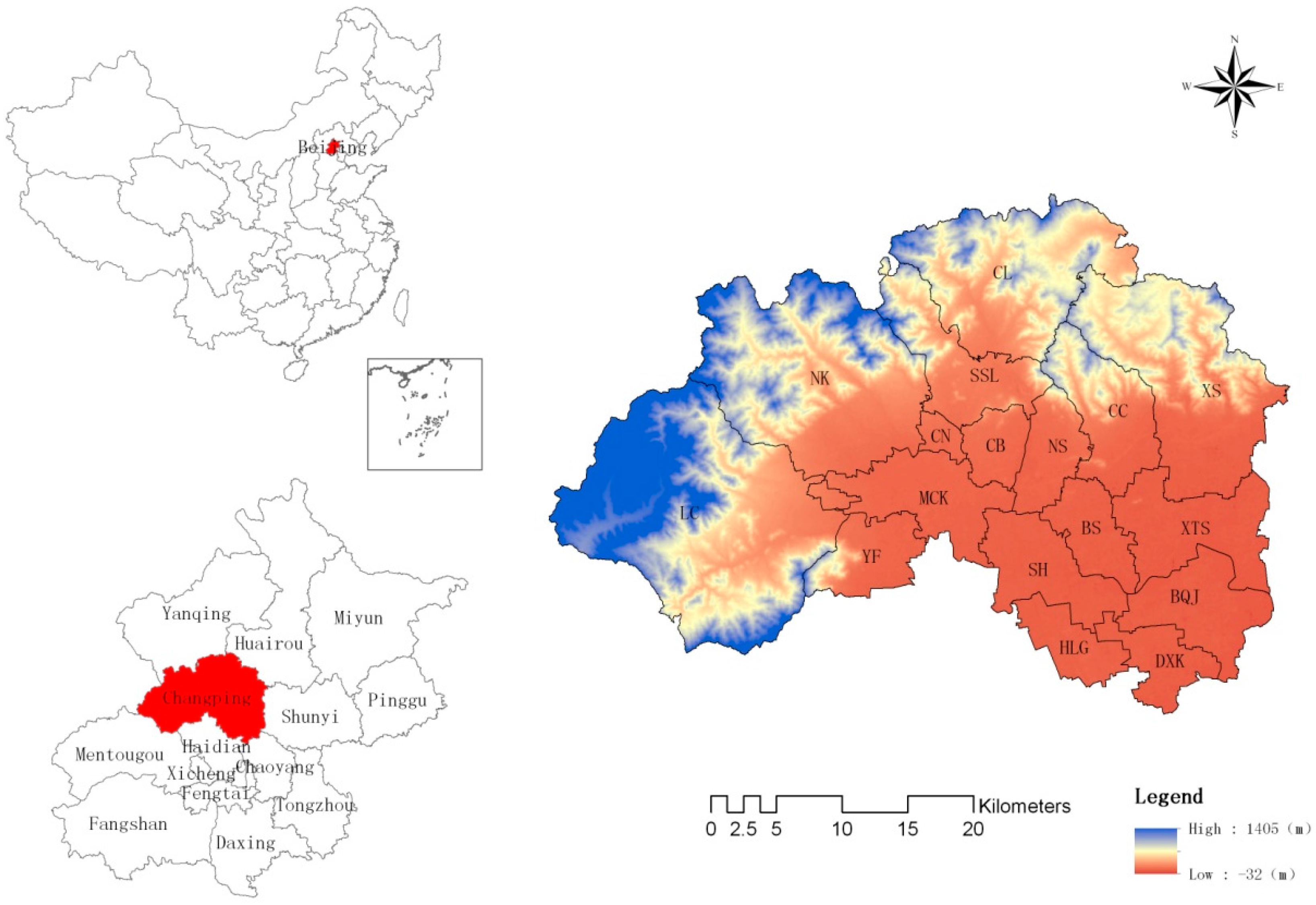
This study takes Changping district in Beijing as its research area. As the capital of China, Beijing is a model for all other cities for its land development and land policies. In addition, Beijing is among China’s fastest-growing cities according to area and population [
33]. Between 2001 and 2010, Beijing’s total population increased from 13.85 million to 19.62 million, while its agricultural population fell from 3.04 million to 2.76 million. During the same period, the area of developed land in Beijing rose from 2858.38 km
2 to 3199.08 km
2, an average annual growth of 34 km
2.
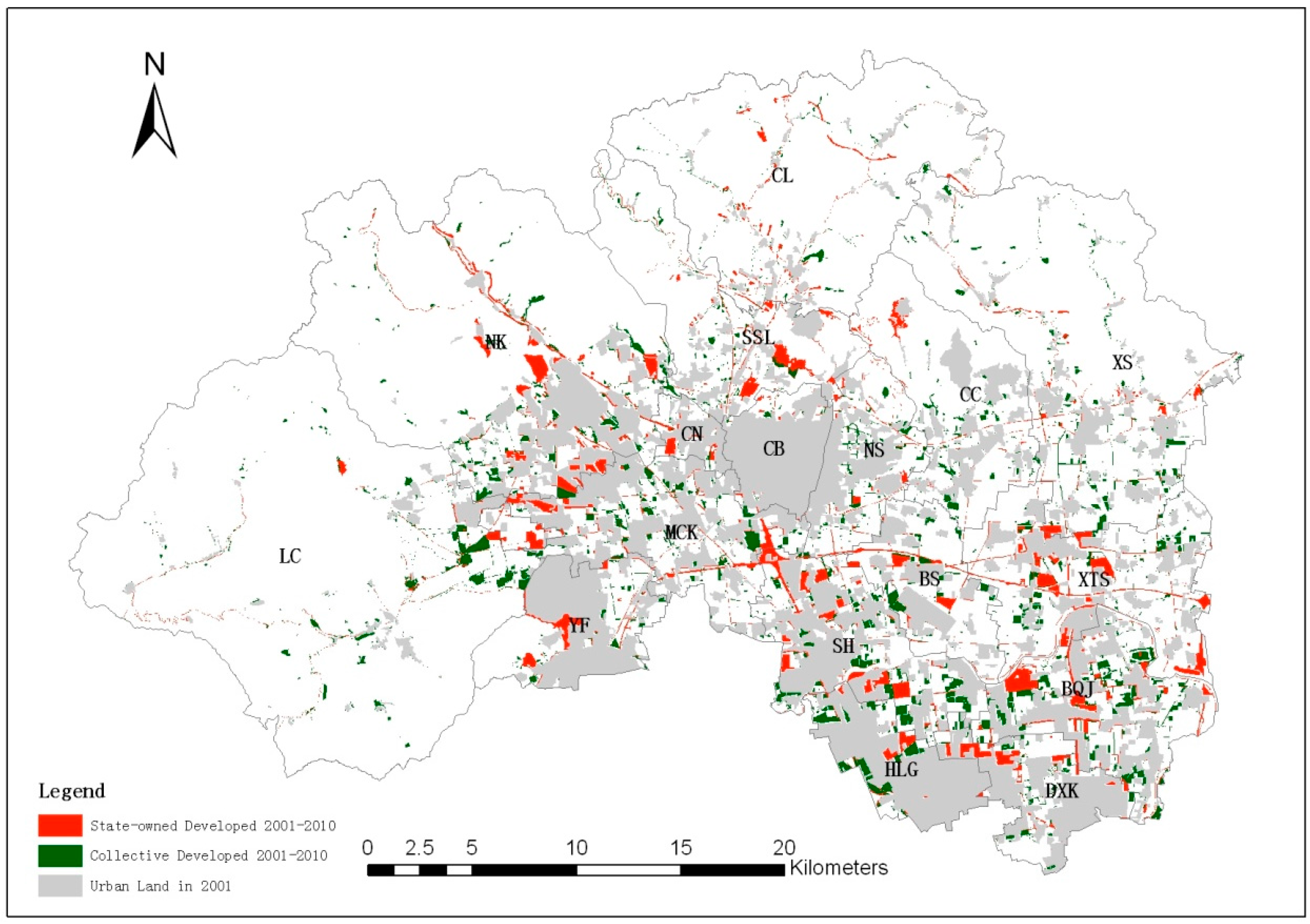
As a typical urban fringe area in Beijing (
Figure 1) and located northwest of the city center, Changping district is one of the main areas to have accommodated Beijing’s rapid urban expansion. It is the location of the first highway from the city center to its outskirts. Changping district is also a miniature version of Beijing in terms of topography, with mountains in the northwest and plains in the southeast. Therefore, many researchers have selected Changping district as a representative research area of Beijing [
34,
35,
36].
Changping district has a total area of 1342.57 km
2 and is subdivided into 17 towns and townships. The population of the district was 1,661,000 in 2010, with only 533,000 registered, which means a lot of people are migrants. Among the registered population, the urban population was 326,000 and the rural population was 207,000 in 2010, suggesting a lower proportion of primary industries. The average incomes of the urban and rural residents were ¥24,428.3 ($3545.7) and ¥14,384.3 ($2087.8) respectively in 2010 [
37]. Three highways link the district with the city center, namely the north-south Beijing–Tibet expressway, the Beijing–Chengde expressway, and the Litang road. The district connects to the city center by subway lines 5, 8, and 13, and the Changping line. In addition, the sixth ring road passes through the southern part of the district, from east to west. Given its locational and transport advantages, Changping district has experienced fast development, and its developed land area has increased from 252.47 km
2 in 2001 to 338.28 km
2 in 2010, growing at an average rate of 8.58 km
2 per year.
3.2. Data
In this study, we collected the 2001 and 2010 land-use survey data of Changping district, from which we put forward the dependent variable through an overlay analysis and assigned each grid with a value, representing whether it was development with or without land ownership change. Among the independent variables that we selected as potentially influencing land development, we acquired a digital elevation model from the computer network center of the Chinese Academy of Sciences, which we used to derive the gradient data in ArcGIS 10.2 (ESRI, Redlands, CA, USA). We extracted major roads, minor roads, and the sixth ring road, and developed land from the 2010 land use dataset, subway stations, district governments, township governments, and village committees by digitizing their coordinates; the population at the street level from the fifth and sixth population censuses; farmers’ income data from statistical yearbooks; prior land use type from the 2001 land use dataset; and construction area from land use planning and city planning datasets between 2001 and 2010. After all of this data collection was completed, we converted the spatial vector information into a 100 × 100 m raster, with each grid cell containing all the variables listed above.
3.3. Methods
In order to investigate the first research question, we employed spatial statistics and a descriptive analysis to study whether there were differences in the spatial distribution between formal land development that transferred into state ownership and informal land development that remained in collective ownership from 2001 to 2010. We tested whether there were significant differences between these two classes of developed land in terms of their area, usage, source, the number of land blocks, distances from the governments and roads, and so on.
We set up a multinomial logit model to address the second research question. The advantage of this model is that it can measure the relationship between the categorical dependent variable and many independent variables [
38,
39,
40]. A multinomial logit model is, therefore, appropriate for analyzing the influences of the variables on the expansion of construction activities in designated grid cells [
41]. Using this model, we estimated the probability that a given grid of non-developed land would be developed along the two pathways, and we tested whether the potential factors that affect land development have the same or different influences. In our model, the dependent variable can take three values for each grid: 1 if land was developed but remained in collective ownership, 2 if land was developed and converted into state ownership, and 0 if land remained in agricultural use.
The multinomial logit model is of the form:
where p represents the probability of land development and k ranges from 0 to 2, X is a vector of independent variables, and β is the vector of regression coefficients specific to land-use transition alternative k. In a multinomial logit model, as in a logit model, regression coefficients are estimated up to a scale factor, and the coefficients for the base outcome are set to zero. An odds ratio is used to explain the regression coefficients of various independent variables (such as continuous variables and categorical variables) in a multinomial logit model. In the application of logistic regression, the odds ratio is used to explain the effect of independent variables using the following formula:
The relationship between the dependent and independent variables is reflected by the regression coefficient (eβi). When eβi > 1, the possibility that non-developed land will be converted to developed land increases as the independent variable increases, with odds increasing eβi times as the independent variable increases by one unit, and vice versa. If eβi = 1, the possibility of land expansion does not change as the independent variable changes.
We estimated the model by using Stata 12 with the mlogit command.
3.4. Selection of Independent Variables
Based on the existing studies on the driving forces of land development, we selected seven categories of factors for our study: terrain, transportation infrastructure, spatial location, socioeconomic condition, land use in 2001, planning policy, and spatial autocorrelation [
24,
38,
39,
42,
43,
44].
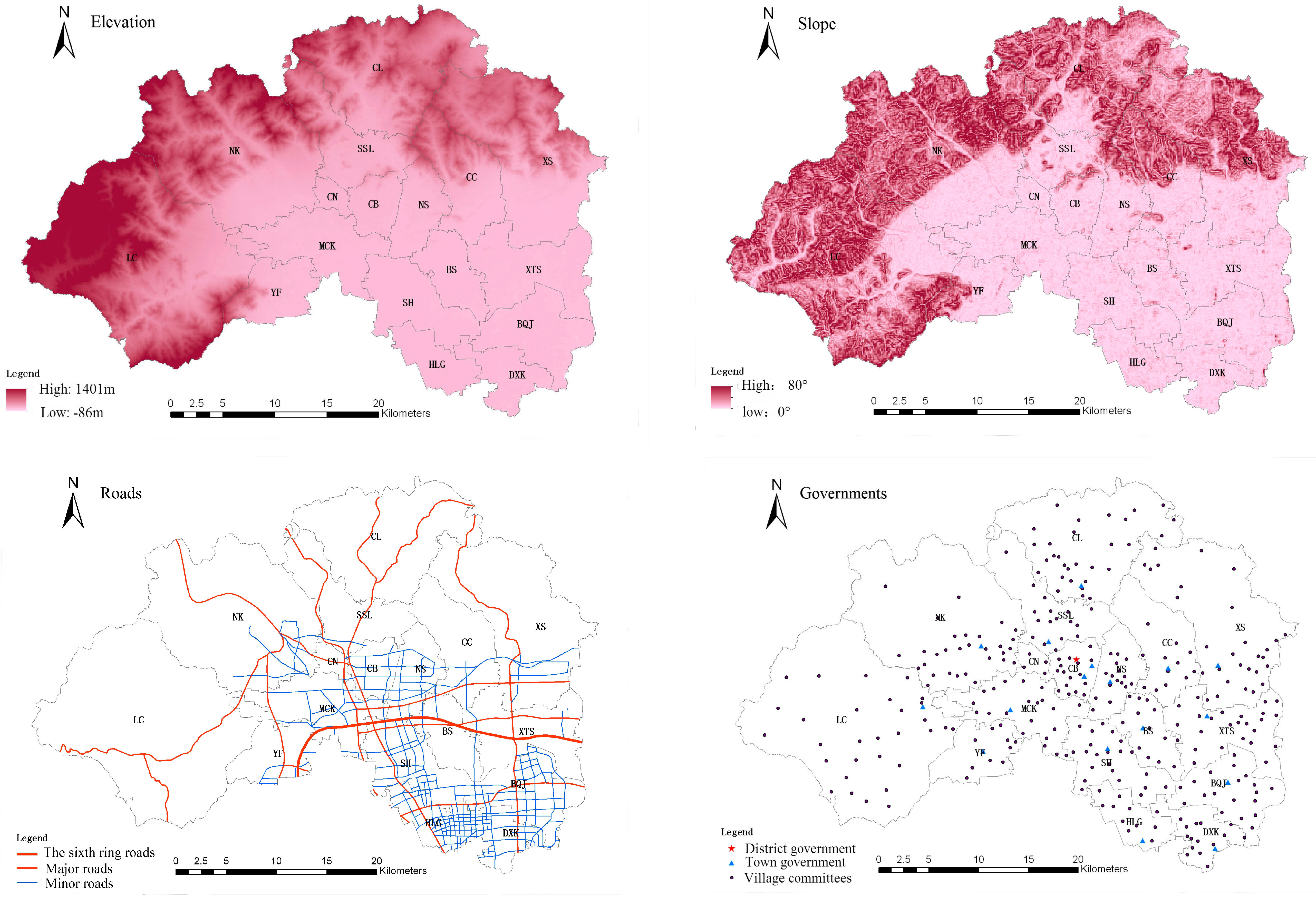
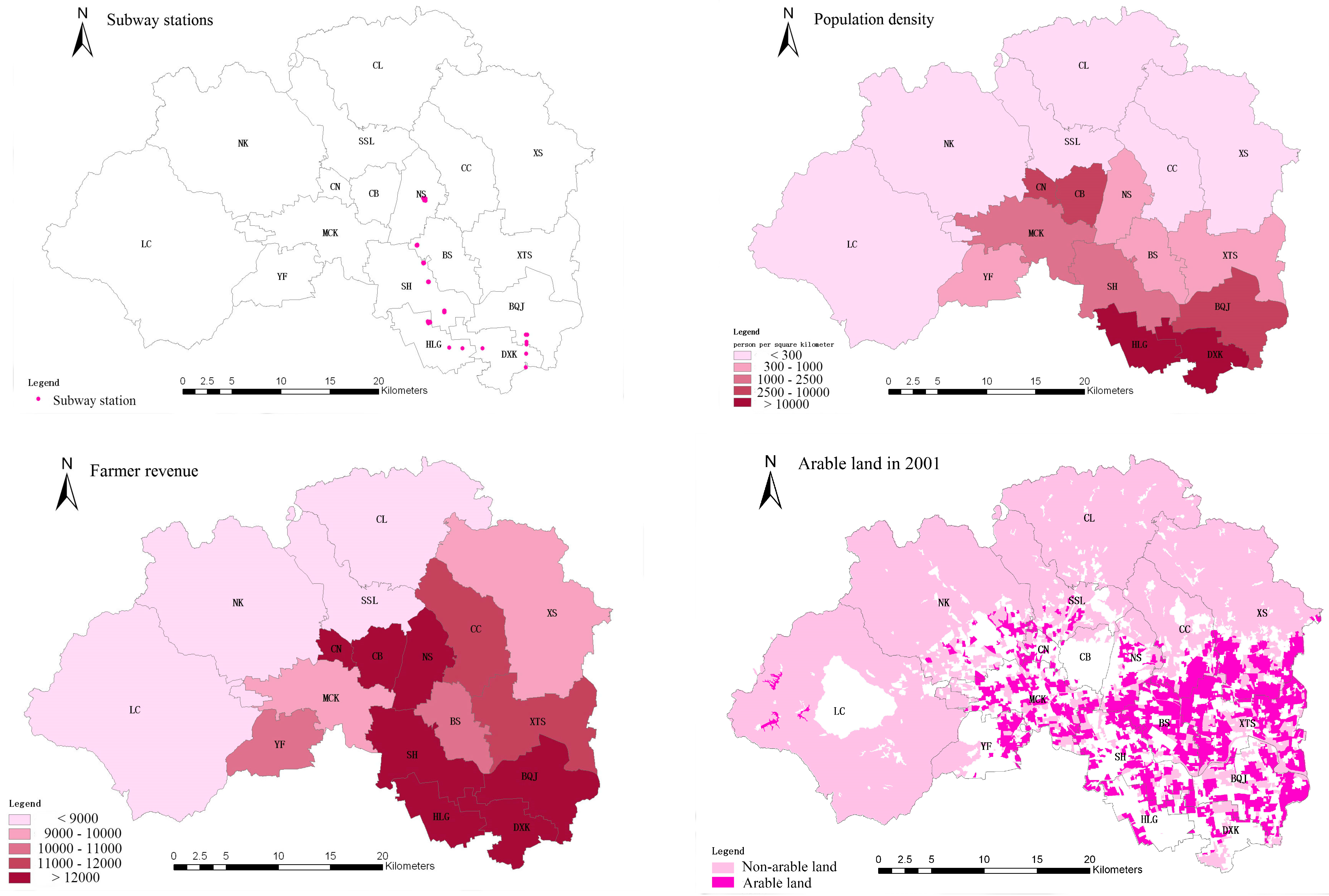
Table 1 and
Figure 2 provide details on all the selected variables.
Elevation, gradient, and other topographic conditions can affect the layout of regional development. The higher the elevation and the gradient, the greater the risk of soil erosion and ecological damage. There is, thus, a corresponding need to increase the cost of investment in prevention and treatment projects in these areas, which is a direct impact on the cost of their development and construction. There is a relatively large elevation range in the study area, which has a gradual northwest to southeast incline. The western mountains are at an elevation of between 400 m and 800 m, which makes developing land there more difficult and costly. Considering all these facts, we chose elevation (X1) and gradient (X2) as independent variables to reflect the terrain conditions in the study area.
Transport conditions also play an important role in the process of urban expansion. Because transportation infrastructure not only reduces construction costs but also facilitates the daily lives of residents, places with good transport accessibility often have a higher likelihood of urban expansion. Roads of different types may have different degrees of impact. In this study, we divided roads into major roads (X3) (including the Beijing–Tibet Expressway, the Beijing–Chengde Expressway, the Litang road, and the North sixth ring, as well as other regional roads like the Shunsha road and the Nanyan road) and minor roads (X4) (mainly local highways and county roads). In addition, we also used the distance from the nearest subway station as an independent variable (X5) to capture the subway’s influence. Subway stations that had been completed by 2010 were selected, including subway line 5 (operational in 2007), line 13 (operational in 2003), and the Changping line (operational in 2010). Although the Changping line was operated at the end of the study period, we regarded it as influential since its construction had already attracted widespread attention and development around it.
Spatial location is another important factor that affects land use change. One basic insight of urban economic theories is that as distance to a city center increases, land development intensity, and population density decreases. Considering the strong attractiveness of the city center of Beijing and the administrative powers of each level of government, we included the distance to the city center, as well as to the nearest district government (X
6), town government (X
7), and village committee (X
8), as independent variables. However, when checking the collinearities between the independent variables, we found high correlation coefficients for the distance to the city center, and thus we excluded it from our model. Given the importance of the sixth ring road in the expansion of Beijing, we also considered whether a grid inside the sixth ring road was an independent variable. Finally, we included a variable that measures the distance to land already developed in 2001 (X
10) since there are studies indicating that land development is more likely to arise near built-up areas [
45]. In addition to spatial location, socioeconomic conditions also matter in urban development. For example, in Beijing, the large number of migrants who have moved from elsewhere has become one of the main driving forces of urban growth [
32]. Moreover, incomes are also critical for demand and willingness to carry out land development. We, therefore, defined two variables—the change of population density (X
11) and farmers’ income (X
12)—as indicators of socioeconomic conditions.
Previous land use types are also influential for land development, especially in China. However, the direction is unclear. On the one hand, development favors farmland over forest land for its flat terrain; on the other hand, China has implemented a strict farmland protection policy to prevent cultivated land loss. Nevertheless, we included land use type in 2001 as an additional independent variable (X13).
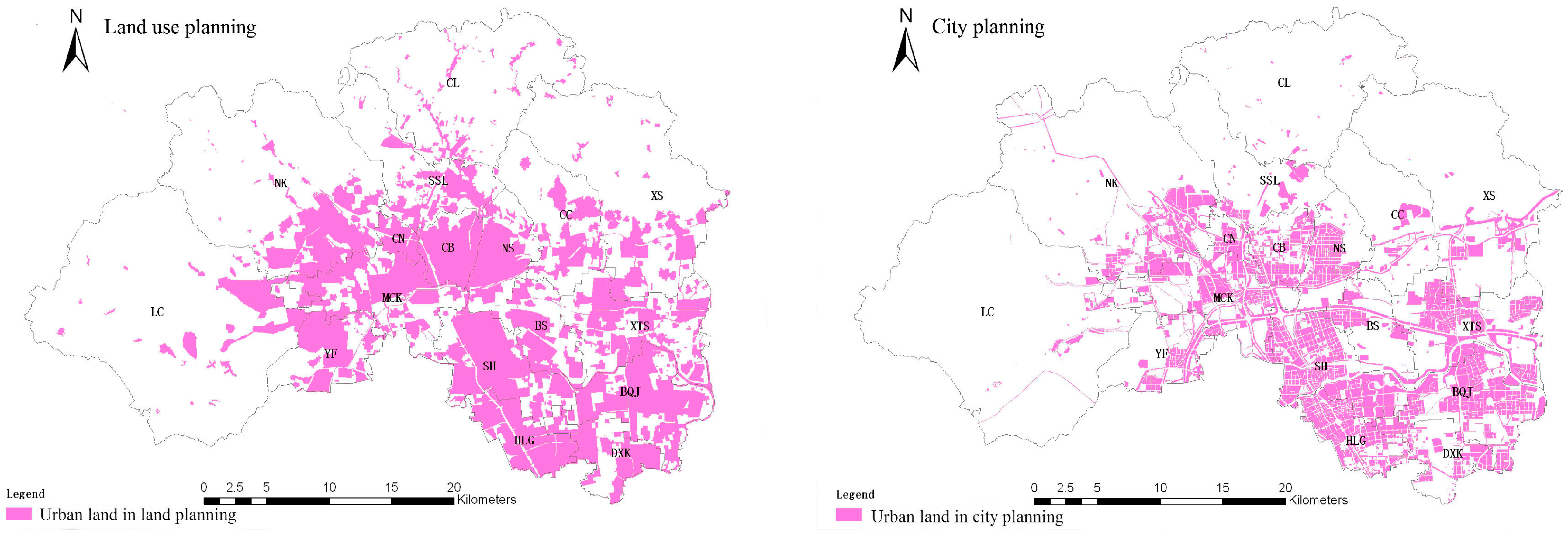
Land development is also dependent on planning and related policies. While policies are too complicated to simply quantified, we defined and included two independent variables to capture the impact of plans, which reflect whether a given grid is zoned for development in the Beijing Municipal Land Use Plan (X14) and Changping District Town Plan (X15), respectively.
Finally, considering the possible spatial autocorrelation effect, we included a variable (X
16) to measure it. The variable is defined as follows:
where y
j is the land use types in the vicinity of spot i. When it occurs, y
j is equals to 1, otherwise it equals 0. d
ij is the distance between space spot pair i and j; only those space spot pairs whose distance is smaller than the distance threshold can be included in the calculation.
4. Land Use Change in Changping
From 2001 to 2010, in Changping district, the total amount of land development came to 85.81 km
2, of which 41.09 km
2 was transferred into state ownership and 44.72 km
2 remained collective owned (
Figure 3 and
Table 2). The newly added, state-owned developed land was mainly used for improving living conditions, including residential real estate development and public infrastructure and facilities. In contrast, a certain portion of newly added collective-owned developed land was used for industrial and mining activities, comprising a total area of 14.78 km
2 and accounting for 33.05% of such land. Collective-owned developed land includes more vacant land than state-owned developed land. When it comes to the sources of newly added developed land, collective developed land was derived more from arable land, with a total area of 21.46 km
2 and accounting for 47.99% of all collective land development in this period (
Table 3).
In 2001, we also compared the average land block size of new collective and state-owned developed land, as well as measuring the average distance to roads, subway stations, the city center, and the built-up areas. We used t-tests to examine whether differences in these factors were significant. From the results (
Table 4), it can be seen that there are significant differences between the land development of the two pathways. For example, land development where ownership changed to the state has an average land area of 2.36 ha, much bigger than that which remained in collective ownership (1.08 ha). In terms of spatial distribution, collective-owned land development was located farther from roads, subway stations, and the 2001 built-up areas than state-owned developed land, reflecting lower accessibility to transport infrastructure and a more dispersed pattern. Regarding distances from the government seats of each level, state-owned developed land was closer to district and town governments than collective-owned developed land, but farther from village committees. This also reflected the scattered development of collective-owned developed land. These observations coincide with our understanding. Since most of the collective-owned land development was informal, it tended to occur in remote areas in a more dispersed order and on a smaller scale, in order to reduce the risks attached to illegal development.
This preliminary analysis of land development in Changping district demonstrates that there are differences in collective-owned and state-owned developed land. These differences lie in both the physical conditions and the spatial patterns, reflecting their efficiency and potential impact on the entire region. In the next section, we further explore the factors behind using a multinomial logit model.
5. The Driving Forces of Expansion for Urban State-Owned and Rural Collective-Owned Developed Land
The regression results and associated significance levels are reported in
Table 5. The model shows a substantial degree of significance for the dependent variables, as indicated by the Likelihood Ratio chi
2 statistic of 29,136.05. The value of pseudo R
2 is 0.4386, which indicates that the overall explanatory power of the model is rather good. Most of the explanatory variables are statistically significant at the 0.05 level, suggesting that the spatial distribution of land development is affected by many factors. There is also evidence that some factors have different influences on land development in the two pathways. This is the case for transportation infrastructure, spatial location, social and economic conditions, and initial usage.
The impacts of elevation and gradient on land expansion for the different ownership types are both significant, and with the signs as expected. As elevation or gradient increases, the likelihood of land development declines.
To our surprise, however, the effects of major and minor roads on collective-owned development are not significant, and only the minor roads have a significant influence on state-owned land development. We figure this may be because the major road network is of too large a scale.
Subways play a key role among the many kinds of urban public transportation infrastructure. Since 2003, line 13 and line 5 have entered into use, making travel to central Beijing more convenient and faster. Large-scale residential areas such as Huilongguan and Tiantongyuan are favored by real estate developers and property buyers because they are close to subway stations [
46]. However, the regression results suggest that subway stations affect the land development of different ownership in different directions. Land within 3 km of a subway station is more likely to be developed when under collective ownership, not the other way around. There may be two reasons for this unexpected result. First, formally developed housing projects such as Tiantongyuan and Huilongguan are relatively clustered while the newly developed collective land is relatively scattered and tends to be close to metro lines. Second, the current Beijing subway development is a kind of a ‘remedy’ for already developed areas, meaning that areas with sufficient demand for a subway line on account of their high employment or residential population will see a line constructed.
In terms of spatial location, distance to a district government seat has a negative impact on state-owned land development, but a positive impact on collective-owned land development. This suggests the administrative and political influences on state-owned land development. Therefore, there tends to be a clustering effect on state-owned land expansion. In fact, district governments are generally willing to nationalize land for land revenue, attracting firms and businesses. On the other hand, collective land expansion tends to occur further away from the district center in order to avoid punishment and regulatory enforcement for informal development. The effect of distance to a town government seat is not significant for either state-owned land development or collective-owned land development, probably due to towns or townships not having the authority to acquire land or sell land use rights. However, distance to village committees does have a negative effect on collective land development, suggesting farmer collectives have a strong urge to participate in the development of collective land. The regressed results show that every additional kilometer from the nearest village committee reduces the probability of collective land expansion by 24% (odds ratio, 0.76) and increases that of state-owned land expansion by 42% (odds ratio, 1.42). The impact of the sixth ring road is not significant for either property type, suggesting that land development in Beijing has well exceeded the sixth ring road. The effect of a parcel’s distance to the already built-up area depends on its ownership type, and only state-owned land development is affected. This suggests that state-owned development tends to occur near urban, areas where people and economic activities already are concentrated and infrastructure and facilities are provided. Collective land development, on the other hand, had no statistical relationship with existing land development in 2001, suggesting a more dispersed development pattern and a lower possibility of taking advantage of infrastructure as well as of industrial agglomeration.
Social and economic conditions also have different influences on land development on the two pathways. For example, farmers’ income has a positive influence on collective-owned land development but a negative effect on state-owned development, suggesting the richer the farmers, the stronger their intention to develop their land on their own. For every 1000 yuan increase in farmers’ income, the probability of collective land development increases by 4% and the probability of state-owned land expansion decreases by 5%. This result is consistent with the argument that the current institutional design of the land use system in fact harms farmers’ interests. When poorer farmers have no other choice but to ‘sell’ their land to the government for limited compensation, richer farmers would rather choose to develop land by themselves, even at the risk of incurring extra costs from engaging in illegal activity. Without access to the windfall profits associated with rising property prices, farmers and village collectives instead put their land into collective land development [
6]. Unlike income level increases, population growth does not have a significant impact on land development on either pathway. We surmise that one reason for this may be that the street (town/township) unit is too big to come under the population’s influence, and another reason may be that a local population consists of only one small part of the source of the strong land development demand in Beijing.
In terms of the previous land usage in 2001, the results suggest that arable land is significantly less likely to be converted to state-owned development land than non-arable land. This suggests the effectiveness of the National Farmland Protection Policies on formal land development. However, land usage in 2001 had no significant impact on collective land development, which is consistent with our observations that collective land development actually occupied more arable land than state-owned land development, threatening the goal of farmland protection in China.
Disappointingly, neither land planning nor new town planning was shown to have any significant effect on collective land development, indicating that these planning functions have little regulatory power over collective land development in the study area. Nevertheless, the result suggests that land planning has a significant positive effect on state-owned land development, which again, indicates that only formal land development is well regulated and controlled while collective-owned land development is, in general, unregulated.
Finally, the spatial autocorrelation variable is significant for both property types. This means that land development has a certain spatial autocorrelation structure in the study area.
6. Conclusions and Policy Implications
In China’s dual urban-rural land system, there are two ways that non-developed land can be improved as urbanization proceeds. Development can be formal if rural land is transferred into state ownership, or it can be informal, such as when land is illegally developed while remaining under collective ownership. Because of restrictions on the transfer of use rights, the latter is a more limited form of property ownership than the former. In this study, we used data from Changping district to address two questions. First, are there spatial differences between new developments on collective- and state-owned land? Second, which factors affect the expansion of development, and do they differ depending on the development pathway? Our main conclusions are as follows:
First, although land has been developed along these two pathways in approximately equal amounts between 2001 and 2010, collective developed land is more scattered and its public infrastructure is weaker. This small-scale decentralized development approach is not conducive to efficient land use [
26,
47].
Second, we found that various factors contribute to the distinctive spatial distribution of new development on collective- and state-owned land. Among the seven factors we identified (topography, transportation infrastructure, spatial location, social and economic conditions, land usage in 2001, planning policy, and spatial autocorrelation), most have produced certain impacts on land development. Topography and spatial autocorrelation each influence the two property types of developed land in the same direction. Whether development is on state-owned or collective land, it tends to occur in places of low elevation, on gently-inclined terrain, and where there is already land development in the area. Unlike these factors, we found that planning policies more tightly control development on state-owned land. The impacts of transportation infrastructure, farmer income, spatial location, and land usage in 2001 depend on property ownership type. Only collective land development clusters around subway stations. Collective land expansion tends to occur around places where farmers have higher incomes, while the opposite is the case for state-owned land. State-owned land development occurs around places close to high-level district governments, while collective land development occurs around places that are close to relatively low-level village centers. Finally, the implementation of farmland protection policies has slowed state-owned development of agricultural land but has had no effect on the use of such land for collective construction projects.
In short, we find that as non-developed land is developed, land development under collective ownership and state ownership are differently distributed spatially, and factors affecting land development are also different on the two pathways. These differences reflect the design of China’s urban-rural land use system, but also demonstrate a certain degree of distortion of market behavior, which may be reducing land use efficiency and leading to unsustainable land development [
48]. For example, while development of state-owned land tends to occur closer to already built-up areas, farmer collectives tend to carry out land development farther away from district centers, where firms and businesses can better benefit from infrastructure and economic agglomeration. Also, the results suggest that farmer collectives have a higher probability of violating planning regulations and the farmland protection policies. In order to make land development fairer and efficient to meet the requirements of sustainability in land utilization and to clarify the rights of collective land users in China’s urbanization process, there is a need to revise and improve the land use system. In recent years, China has proposed serious measures to perfect the existing system and rationalize the use of land, such as establishing a unified urban and rural land market. Based on the results of our regression analysis, we suggest the following changes may allow for the achievement of these goals:
- (1)
The existing land management system should establish effective mechanisms and specific policies to clarify the ownership of collective-owned land, ensure that users of collective-owned land and state-owned land enjoy the same rights, and disincentivize the illegal development of collective land, thus improving land use efficiency.
- (2)
If non-developed rural land is prevented from being used for development and is maintained for agricultural or ecological uses, the government should provide compensation for the farmers for their foregoing development to improve the entire wellbeing of all citizens.
- (3)
Once legalized, farmer collective land development must be regulated strictly so as to achieve the goals of sustainable urban development and farmland protection.


