Combining GIS Applications and Method of Multi-Criteria Decision-Making (AHP) for Landfill Siting in Al-Hashimiyah Qadhaa, Babylon, Iraq


 , ,
, ,
Abstract
:1. Introduction
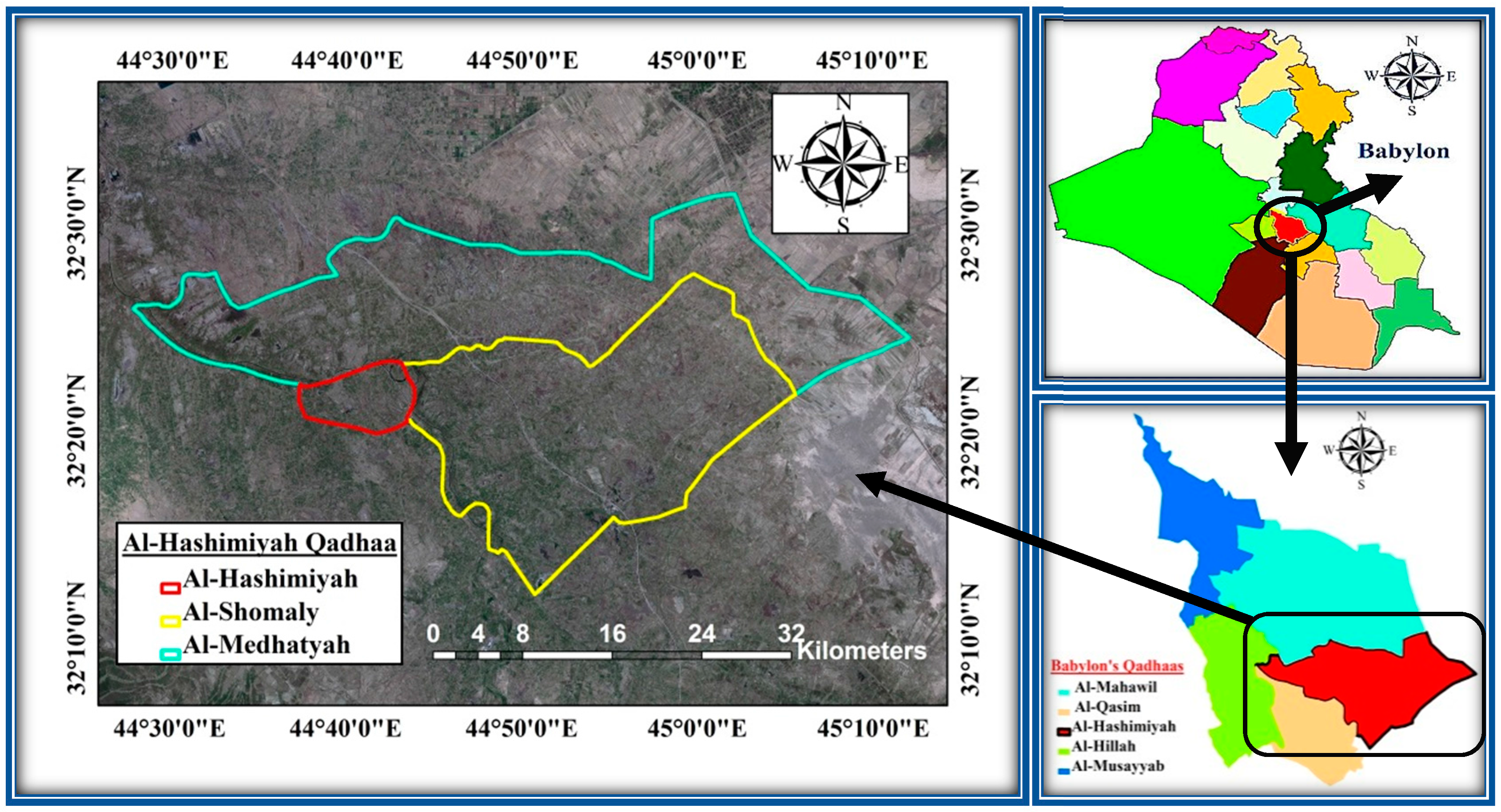
2. Study Area
3. Methodology
- (1).
- Reviewing the previous literature.
- (2).
- Preparing the database of digital maps within GIS software for the study area.
- (3).
- Creating suitable buffer zones or special constraints around important areas to suit each criterion map.
- (4).
- Determination of the weightings of the sub-criteria based on the opinion of experts, literature, environmental and scientific requirements and governmental regulations.
- (5).
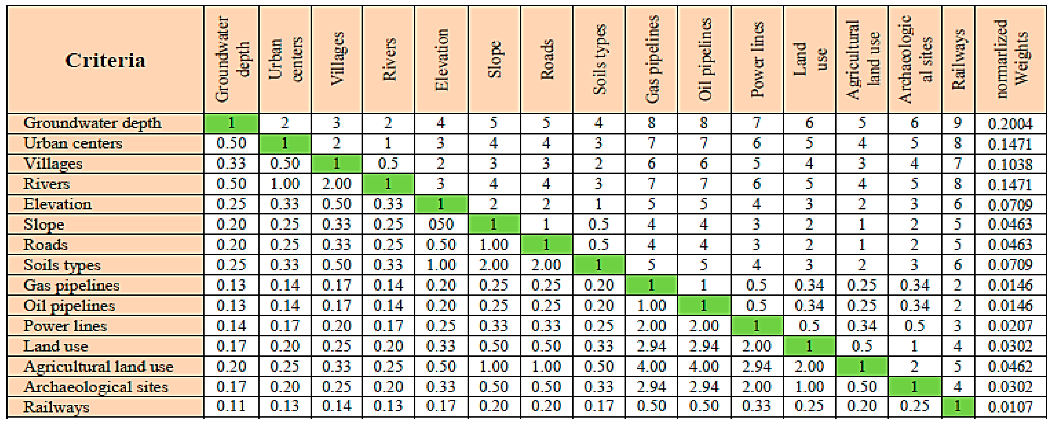
- Determination of the weightings for the criteria using the AHP model.
- (6).
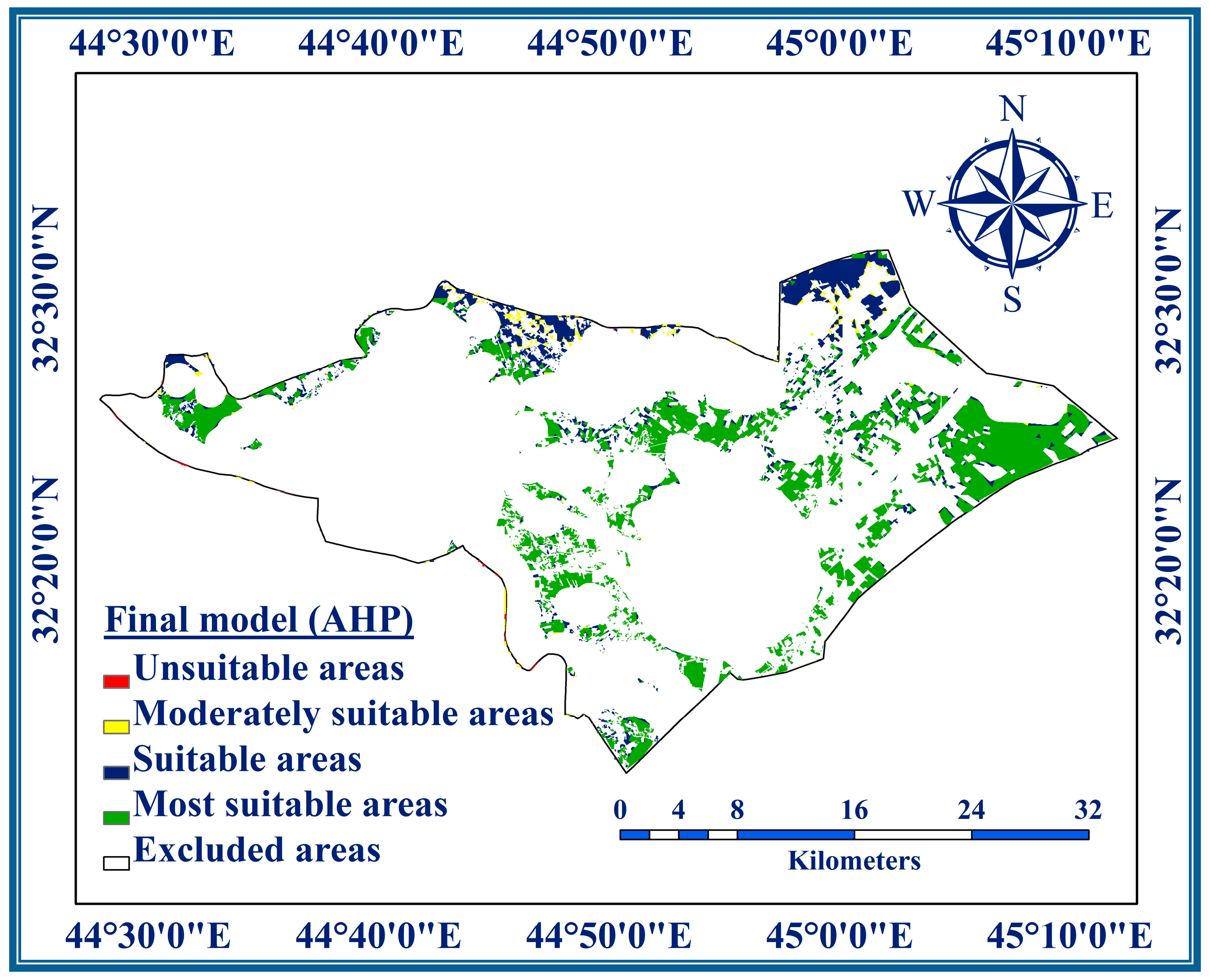
- Exclusion of unsuitable areas for landfill siting from the resulting final map of this study.
- (7).
- Determination of a suitability index to apply to candidate sites for landfill.
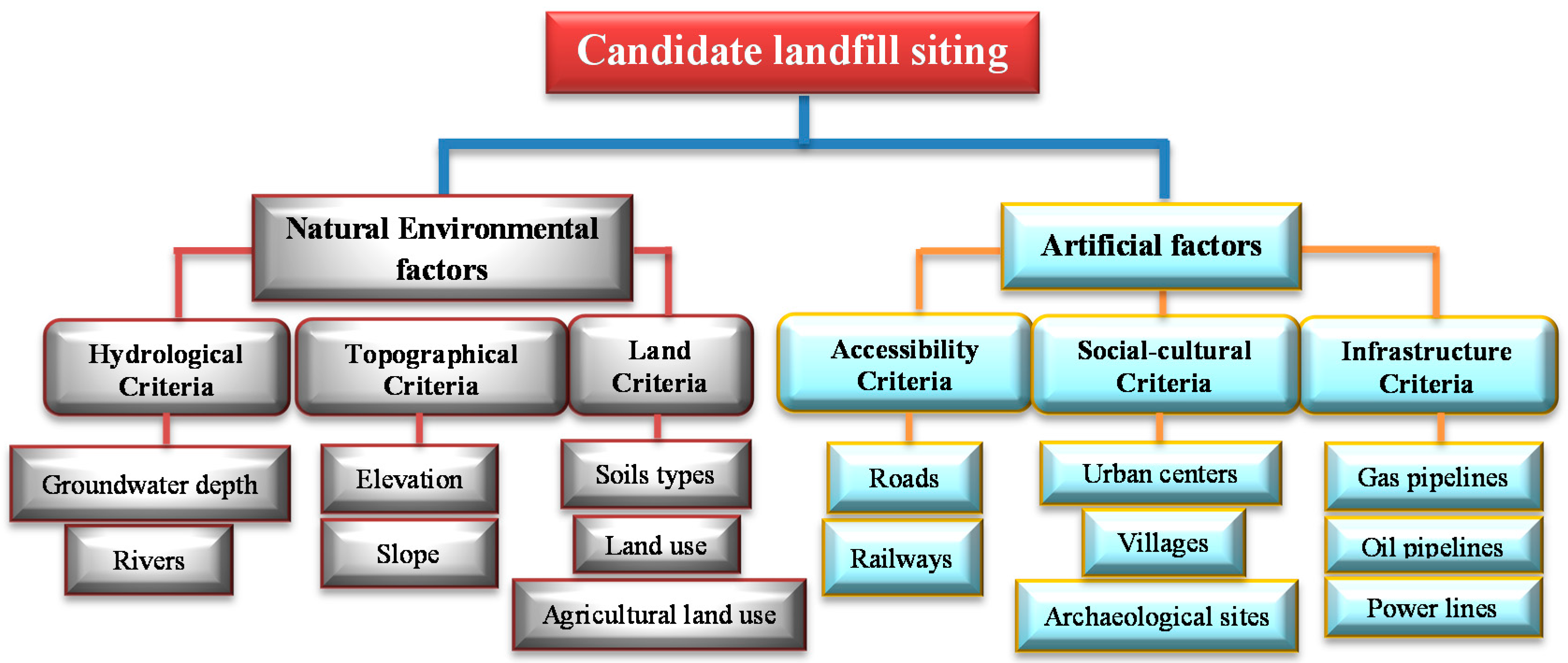
3.1. The Hierarchical Structure Tree for Landfill Siting
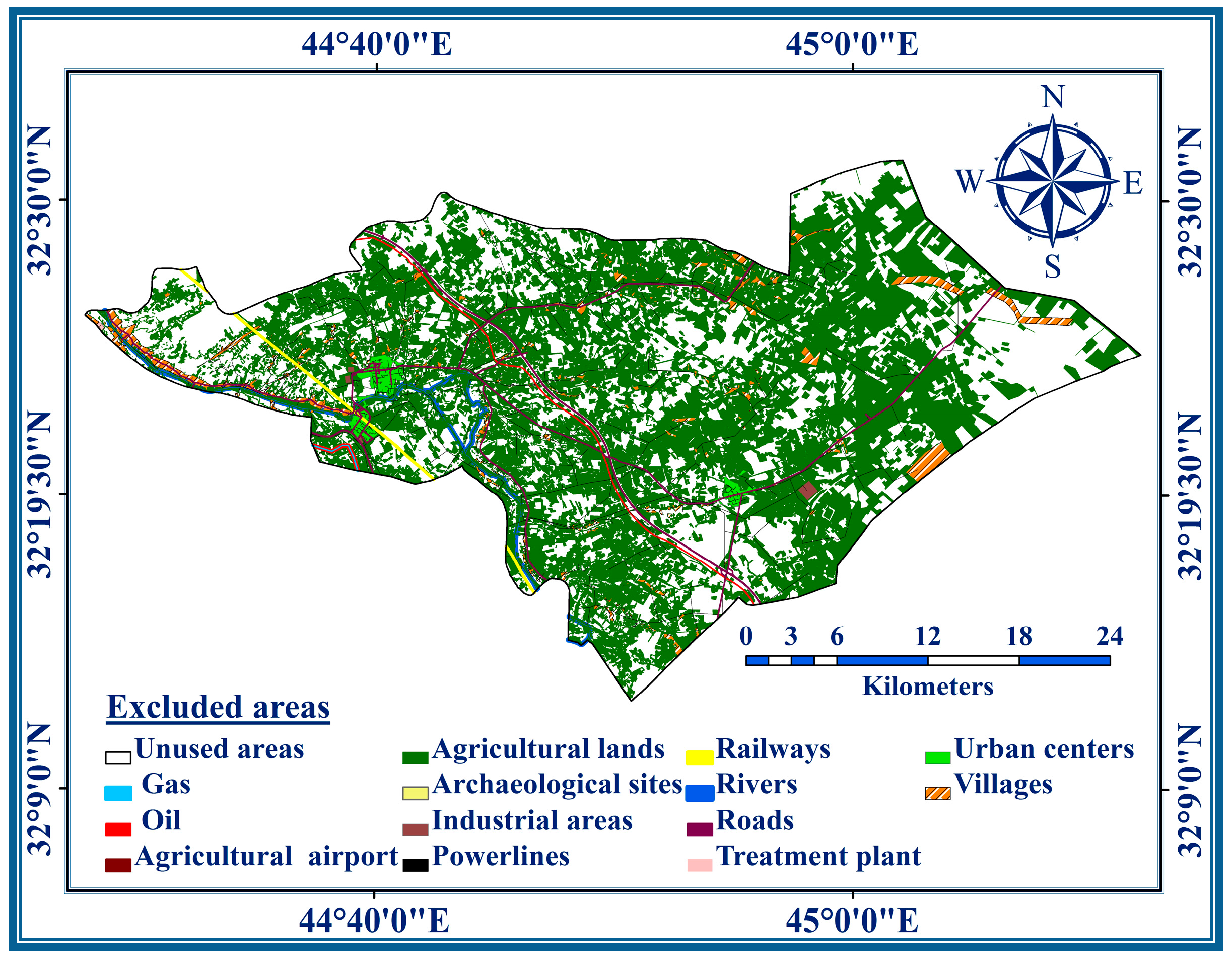
3.2. Restriction Sites
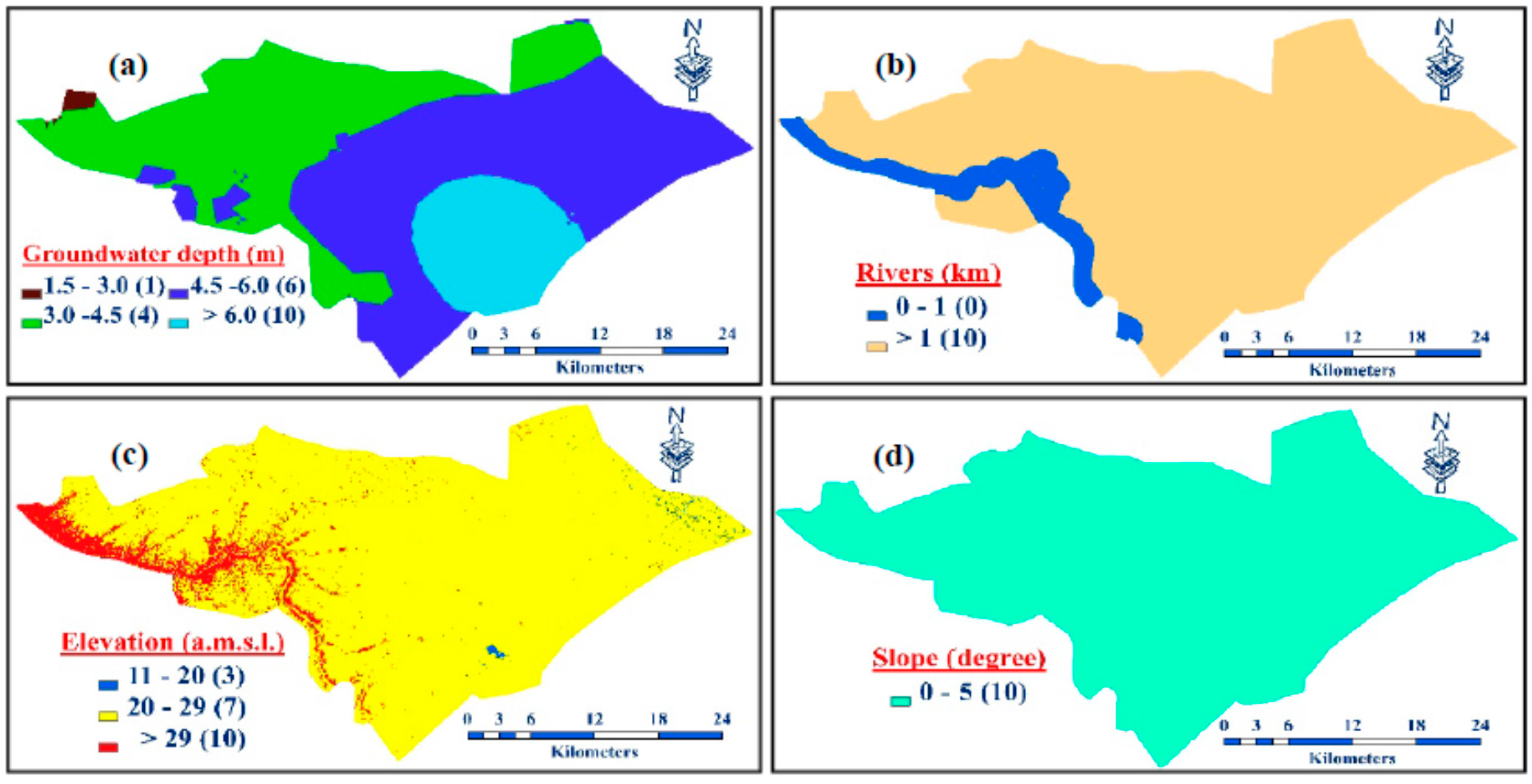
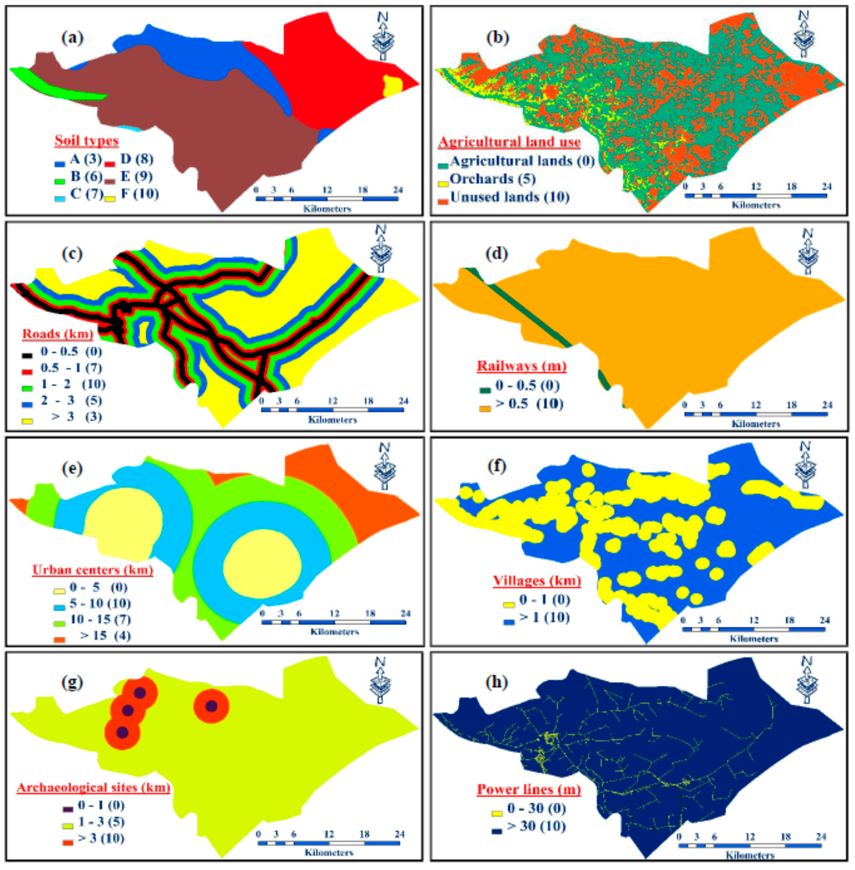
3.3. Layers Maps of Criteria
3.4. Classification and Rating the Sub-Criteria
3.5. Analytical Hierarchy Process (AHP) Method
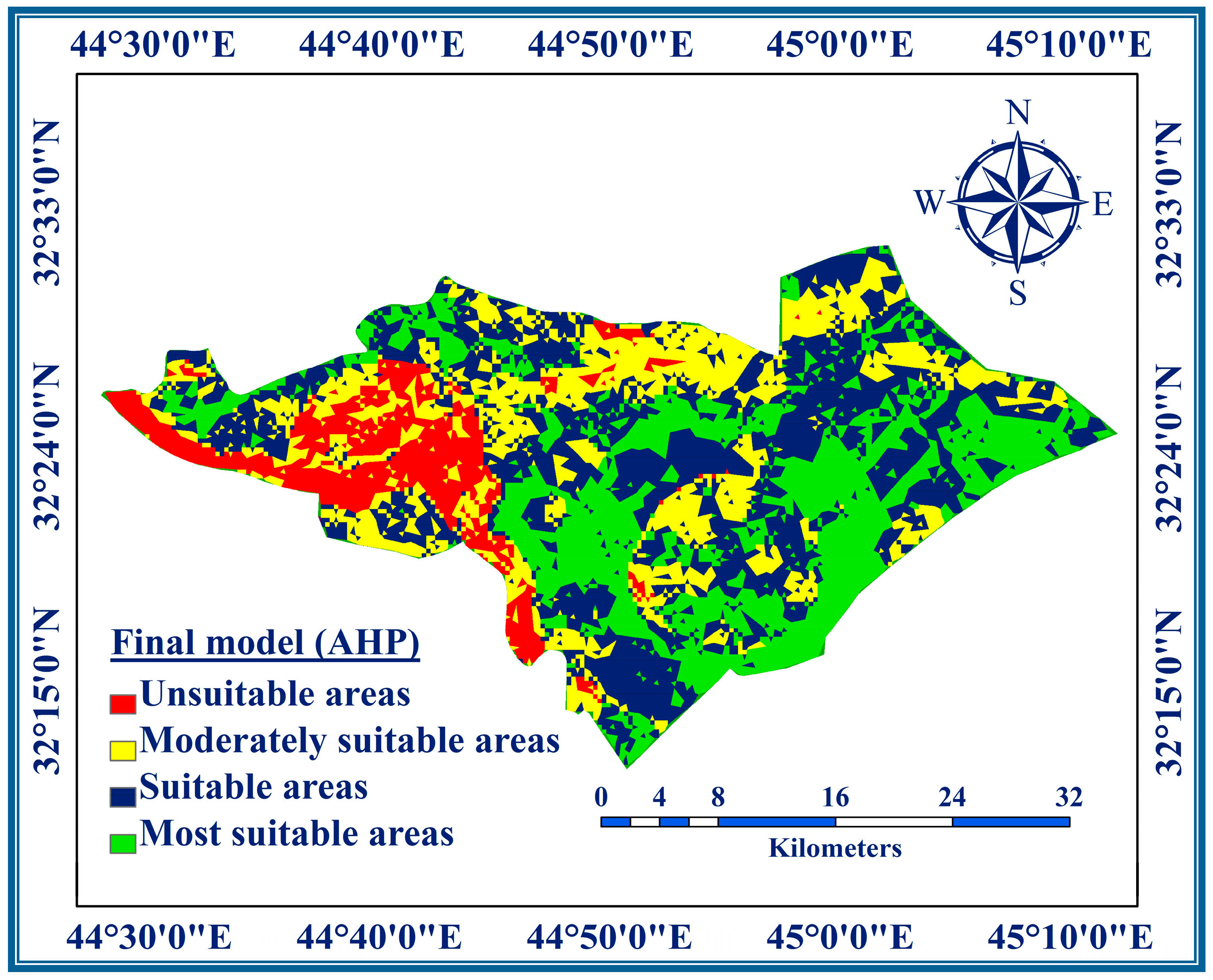
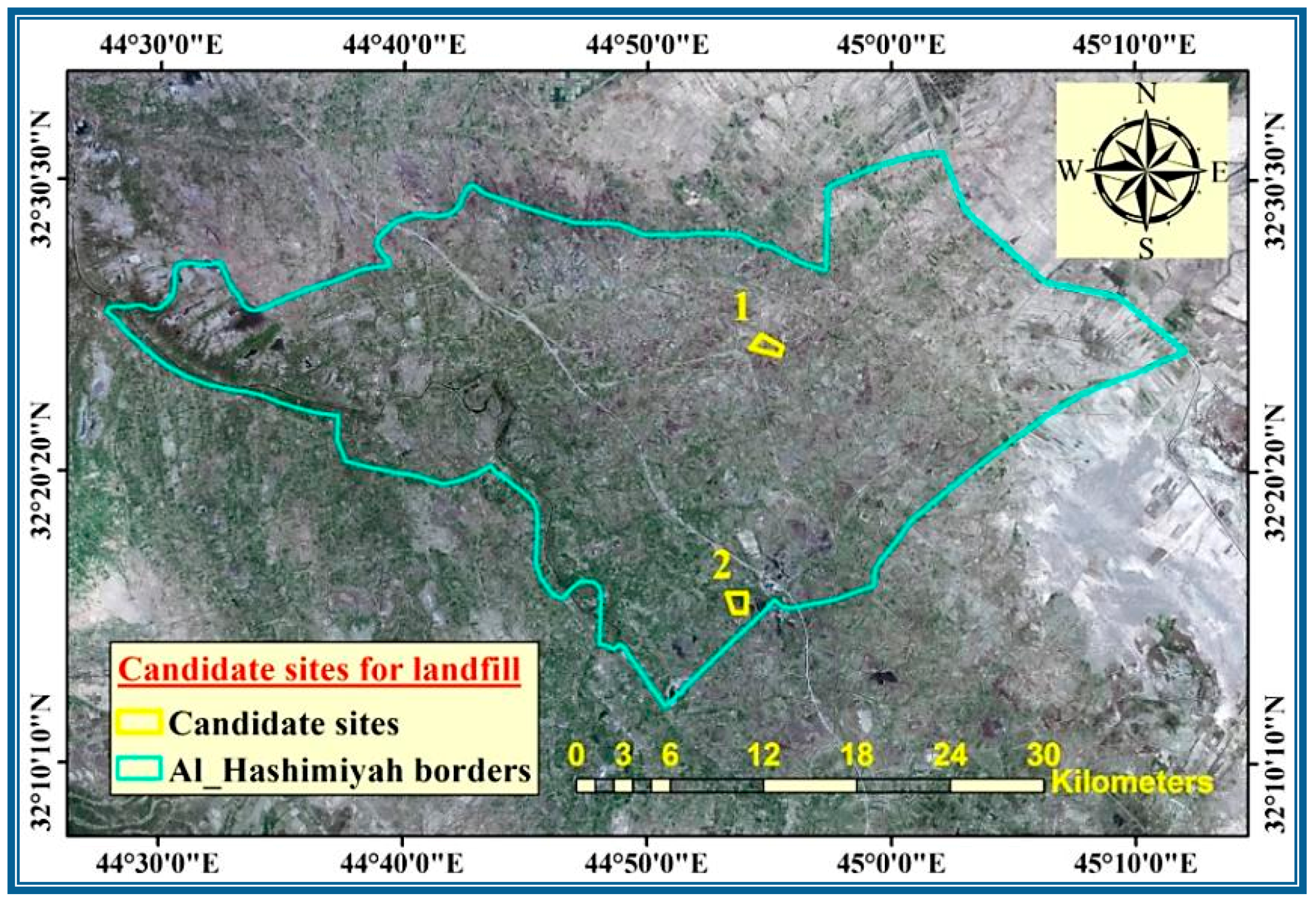
4. Results and Discussion
5. Conclusions
Acknowledgments
Author Contributions
Conflicts of Interest
References
- Guerrero, L.A.; Maas, G.; Hogland, W. Solid waste management challenges for cities in developing countries. Waste Manag. 2013, 33, 220–232. [Google Scholar] [CrossRef] [PubMed]
- Minghua, Z.; Xiumin, F.; Rovetta, A.; Qichang, H.; Vicentini, F.; Bingkai, L. Municipal solid waste management in Pudong New Area, China. Waste Manag. 2009, 29, 1227–1233. [Google Scholar] [CrossRef] [PubMed]
- Moeinaddini, M.; Khorasani, N.; Danehkar, A.; Darvishsefat, A.A.; Zienalyan, M. Siting MSW landfill using weighted linear combination and analytical hierarchy process (AHP) methodology in GIS environment (case study: Karaj). Waste Manag. 2010, 30, 912–920. [Google Scholar] [CrossRef] [PubMed]
- Kontos, T.D.; Komilis, D.P.; Halvadakis, C.P. Siting MSW landfills on Lesvos Island with a GIS based methodology. Waste Manag. Res. 2003, 21, 262–277. [Google Scholar] [CrossRef] [PubMed]
- Yesilnacar, M.I.; Cetin, H. An environmental geomorphologic approach to site selection for hazardous wastes. Environ. Geol. 2008, 55, 1659–1671. [Google Scholar] [CrossRef]
- Kim, K.R.; Owens, G. Potential for enhanced phytoremediation of landfills using biosolids: A review. J. Environ. Manag. 2010, 91, 791–797. [Google Scholar] [CrossRef] [PubMed]
- Siddiqui, M.Z.; Everett, J.W.; Vieux, B.E. Landfill siting using geographic information systems: A demonstration. J. Environ. Eng. 1996, 122, 515–523. [Google Scholar] [CrossRef]
- Lin, H.; Kao, J. Enhanced spatial model for landfill siting analysis. J. Environ. Eng. 1999, 125, 845–951. [Google Scholar] [CrossRef]
- Javaheri, H.; Nasrabadi, T.; Jafarian, M.H.; Rowshan, G.R.; Khoshnam, H. Site selection of municipal solid waste landfills using analytical hierarchy process method in a geographical information technology environment in Giroft, Iran. J. Environ. Health Sci. Eng. 2006, 3, 177–184. [Google Scholar]
- Chabuk, A.; Al-Ansari, N.; Hussain, H.M.; Knutsson, S.; Pusch, R. Present status of solid waste management at Babylon Governorate, Iraq. Engineering 2015, 7, 408–423. [Google Scholar] [CrossRef]
- Alnajjar, A.Y. Solid Waste Management Scenario in Iraq, Middle East, Solid Waste Management, EcoNENA. 2013. Available online: http://www.ecomena.org/tag/solid-waste-management-in-iraq (accessed on 17 January 2016).
- El Alfy, Z.; Elhadary, R.; Elashry, A. Integrating GIS and MCDM to Deal with landfill site selection. Int. J. Eng. Technol. 2010, 10, 32–42. [Google Scholar]
- Delgado, O.B.; Mendoza, M.; Granados, E.L.; Geneletti, D. Analysis of land suitability for the siting of inter-municipal landfills in the Cuitzeo Lake Basin, Mexico. Waste Manag. 2008, 28, 1137–1146. [Google Scholar] [CrossRef] [PubMed]
- Şener, Ş.; Şener, E.; Karagüzel, R. Solid waste disposal site selection with GIS and AHP methodology: A case study in Senirkent–Uluborlu (Isparta) Basin, Turkey. Environ. Monit. Assess. 2011, 173, 533–554. [Google Scholar] [CrossRef] [PubMed]
- Nas, B.; Cay, T.; Iscan, F.; Berktay, A. Selection of MSW landfill site for Konya, Turkey using GIS and multi-criteria evaluation. Environ. Monit. Assess. 2010, 160, 491–500. [Google Scholar] [CrossRef] [PubMed]
- Aksaler, N.; Yerli, S.K.; Erdogan, M.A.; Kaba, K.; Ak, T.; Aslan, Z.; Bakis, V.; Demircan, O.; Evren, S.; Keskin, V.; et al. Astronomical site selection for Turkey using GIS techniques. Exp. Astron. 2015, 39, 547–566. [Google Scholar] [CrossRef]
- Zhu, B.; Nie, Y.; Nan, R.; Peng, B. The FAST/SKA site selection in Guizhou province. Sources Scintill. 2001, 278, 213–218. [Google Scholar]
- Duarte, L.; Teodoro, A.C.; Maia, D.; Barbosa, D. Radio astronomy demonstrator: Assessment of the appropriate sites through a GIS open source application. Int. J. Geol. Inf. 2016, 5, 209. [Google Scholar] [CrossRef]
- Saaty, T.L. The Analytic Hierarchy Process; McGraw Hill: New York, NY, USA, 1980. [Google Scholar]
- Saaty, T.L. Fundamentals of Decision Making and Priority Theory with AHP; RWS Publications: Pittsburg, PA, USA, 2000. [Google Scholar]
- Rahman, A. GIS based DRASTIC model for assessing groundwater vulnerability in shallow aquifer in Aligarh, India. Appl. Geogr. 2008, 28, 32–53. [Google Scholar] [CrossRef]
- Zhong-Wu, L.; Guang-Ming, Z.; Hua, Z.; Bin, Y.; Sheng, J. The integrated eco-environment assessment of the red soil hilly region based on GIS-a case study in Changsha City, China. Ecol. Model. 2007, 202, 540–546. [Google Scholar]
- Vahidnia, M.H.; Alesheikh, A.A.; Alimohammadi, A. Hospital site selection using fuzzy AHP and its derivatives. J. Environ. Manag. 2009, 90, 3048–3056. [Google Scholar] [CrossRef] [PubMed]
- Ramjeawon, T.; Beerachee, B. Site selection of sanitary landfills on the small island of Mauritius using the analytical hierarchy process multi-criteria method. Waste Manag. Res. 2008, 26, 439–447. [Google Scholar] [CrossRef] [PubMed]
- Kara, C.; Doratli, N. Application of GIS/AHP in siting sanitary landfill: A case study in Northern Cyprus. Waste Manag. Res. 2012, 30, 966–980. [Google Scholar] [CrossRef] [PubMed]
- Alavi, M.R.; Mokhtarani, N.; Mokhtarani, B. Municipal solid waste landfill site selection with geographic information systems and analytical hierarchy process: A case study in Mahshahr County, Iran. Waste Manag. Res. 2013, 31, 98–105. [Google Scholar] [CrossRef] [PubMed]
- Khan, D.; Samadder, S.R. Municipal solid waste management using Geographical Information System aided methods: A mini review. Waste Manag. Res. 2014, 32, 1049–1062. [Google Scholar] [CrossRef] [PubMed]
- Uyan, M. MSW landfill site selection by combining AHP with GIS for Konya, Turkey. Environ. Earth Sci. 2014, 71, 1629–1639. [Google Scholar] [CrossRef]
- Iraqi Ministry of Municipalities and Public Works. Structural Plan of Babylon Governorate, The Directorate General of Urban Planning 2009; Information Analysis Report (Revised), Stage 2; Iraqi Ministry of Municipalities and Public Works: Baghdad, Iraq, 2009; p. 223.
- Iraqi Ministry of Planning. Records of Directorate of Census Babylon, Internal Reports; Iraqi Ministry of Planning: Baghdad, Iraqi, 2015.
- Iraqi Ministry of Municipalities and Public Works. Records of Directorate of Babylon Municipalities; Iraqi Ministry of Municipalities and Public Works: Baghdad, Iraqi, 2015.
- Şener, B. Landfill site selection by using geography information System. Master’s Thesis, Middle East Technical University, Çankaya/Ankara, Turkey, August 2004. [Google Scholar]
- Eskandari, M.; Homaee, M.; Mahmodi, S. An integrated multi criteria approach for landfill siting in a conflicting environmental, Economical and socio-cultural area. Waste Manag. 2012, 32, 1528–1538. [Google Scholar] [CrossRef] [PubMed]
- Yildirim, V. Application of raster-based GIS techniques in the siting of landfills in Trabzon Province, Turkey: A case study. Waste Manag. Res. 2012, 30, 949–960. [Google Scholar] [CrossRef] [PubMed]
- Demesouka, O.E.; Vavatsikos, A.P.; Anagnostopoulos, K.P. GIS-based multicriteria municipal solid waste landfill suitability analysis: A review of the methodologies performed and criteria implemented. Waste Manag. Res. 2014, 32, 270–296. [Google Scholar] [CrossRef] [PubMed]
- Jassim, S.Z.; Goff, J.C. Geology of Iraq; Dolin, Prague and Moravain Museum: Brno, Czech Republic, 2006; p. 356. [Google Scholar]
- Buringh, P. Soils and Soil Conditions in Iraq; The Ministry of Agriculture: Baghdad, Iraq, 1960; p. 337.
- Zeiss, C.; Lefsrud, L. Analytical framework for waste-facility siting. J. Urban Plan. Dev. 1995, 121, 115–145. [Google Scholar] [CrossRef]
- Baban, S.M.; Flannagan, J. Developing and implementing GIS assisted constraints criteria for planning landfill sites in the UK. Plan. Pract. Res. 1998, 13, 139–151. [Google Scholar] [CrossRef]
- Tagaris, E.; Sotiropoulou, R.P.; Pilinis, C.; Halvadakis, C.P. A methodology to estimate odors around landfill sites: The use of methane as an odor index and its utility in landfill siting. J. Air Waste Manag. Assoc. 2003, 53, 629–634. [Google Scholar] [CrossRef] [PubMed]
- Effat, H.A.; Hegaz, M.N. Mapping potential landfill sites for North Sinai cities using spatial multicriteria evaluation. Egypt. J. Remote Sens. Space Sci. 2012, 15, 125–133. [Google Scholar] [CrossRef]
- Charnpratheep, K.; Zhou, Q.; Garner, B. Preliminary landfill site screening using fuzzy geographical information systems. Waste Manag. Res. 1997, 15, 197–215. [Google Scholar] [CrossRef]
- Şener, B.; Suzen, L.M.; Doyuran, V. Landfill site selection by using geographic information systems. Environ. Geol. 2006, 49, 376–388. [Google Scholar] [CrossRef]
- Chabuk, A.; Al-Ansari, N.; Hussain, H.M.; Knutsson, S.; Pusch, R. GIS-based assessment of combined AHP and SAW methods for selecting suitable sites for landfill in Al-Musayiab Qadhaa, Babylon, Iraq. Environ. Earth Sci. 2017, 76, 209–220. [Google Scholar] [CrossRef]
- Ersoy, H.; Bulut, F. Spatial and multi-criteria decision analysis-based methodology for landfill site selection in growing urban regions. Waste Manag. Res. 2009, 27, 489–500. [Google Scholar] [CrossRef] [PubMed]
- Wang, G.; Qin, L.; Li, G.; Chen, L. Landfill site selection using spatial information technologies and AHP: A case study in Beijing, China. J. Environ. Manag. 2009, 90, 2414–2421. [Google Scholar] [CrossRef] [PubMed]
- Isalou, A.; Zamani, V.; Shahmoradi, B.; Alizadeh, H. Landfill site selection using integrated fuzzy logic and analytic network process (F-ANP). Environ. Earth Sci. 2013, 68, 1745–1755. [Google Scholar] [CrossRef]
- Gupta, R.; Kewalramani, M.A.; Ralegaonkar, R.V. Environmental impact analysis using fuzzy relation for landfill siting. J. Urban Plan. Dev. 2003, 129, 121–139. [Google Scholar] [CrossRef]
- Iraqi Ministry of Education. Data of the Directorate General, Internal Reports; The Department of Scientific Affairs: Baghdad, Iraqi, 2015.
- Iraqi Ministry of Water Resources. State Commission of Survey, Internal Reports; Iraqi Ministry of Water Resources: Baghdad, Iraqi, 1990.
- Iraqi Ministry of Municipalities and Public Works. Directorate of Sewage Babylon, Internal Reports; Iraqi Ministry of Municipalities and Public Works: Baghdad, Iraqi, 2011.
- World Digital Library. The Archaeological Map of Iraq. 2013. Available online: http://www.wdl.org/en/item/212/ (accessed on 24 September 2015).
- Iraqi Ministry of Water Resources. General Commission for Groundwater, Internal Reports; Iraqi Ministry of Water Resources: Baghdad, Iraqi, 2015.
- Hussain, M.H. Assessment of Groundwater Vulnerability in an Alluvial Interfluve Using GIS. Ph.D. Thesis, Indian Institute of Technology Roorkee, Roorkee, Uttarakhand, India, September 2004. [Google Scholar]
- Coyle, G. The Analytic Hierarchy Process (AHP), Practical Strategy 2004, Open Access Material. Available online: https://training.fws.gov/courses/references/tutorials/geospatial/CSP7306/Readings/AHP-Technique.pdf (accessed on 20 January 2016).


| No. | Criteria | Buffer Zone | Researchers’ Suggested Buffers |
|---|---|---|---|
| 1 | Rivers | 1 km | 1 km [33,34]. |
| 2 | Roads | 0.5 km | 0.5 km [14,43]. |
| 3 | Railways | 0.5 km | 0.5 km [15,46]. |
| 4 | Urban centers | 5 km | 5 km [41,47]. |
| 5 | Villages | 1 km | 1 km [14,42]. |
| 6 | Archaeological sites | 1 km | 1 km [45,48]. |
| 7 | Gas pipelines | 300 m | 250 m [14]. |
| 8 | Oil pipelines | 75 m | 250 m [28]. |
| 9 | Power lines | 30 m | 30 m [34,43]. |
| No. | Criterion | Sub-Criteria Values | Sub-Criteria Ratings (R) | Criterion’s Weight (AHP) | Area% |
|---|---|---|---|---|---|
| 1 | Groundwater depth (m) | 1.5–3 | 1 | 0.2004 | 0.54 |
| 3–4.5 | 4 | 37.05 | |||
| 4.5–6.0 | 6 | 47.43 | |||
| >6.0 | 10 | 14.98 | |||
| 2 | Rivers (km) | 0–1 | 0 | 0.1471 | 8.46 |
| >1 | 10 | 91.54 | |||
| 3 | Elevation (a.m.s.l.) | 11–20 | 3 | 0.0709 | 0.36 |
| 20–29 | 7 | 92.94 | |||
| >29 | 10 | 6.70 | |||
| 4 | Slope (degree) | 0–5° | 10 | 0.0463 | 100 |
| 5 | Soils types | Soil 8 (A) | 10 | 0.0709 | 0.9 |
| Soil 5’ (B) | 9 | 56.29 | |||
| Soil 5 (C) | 8 | 26.1 | |||
| Soil 9 (D) | 7 | 0.22 | |||
| Soil 4 (E) | 6 | 2.6 | |||
| Soil 11 (F) | 3 | 13.8 | |||
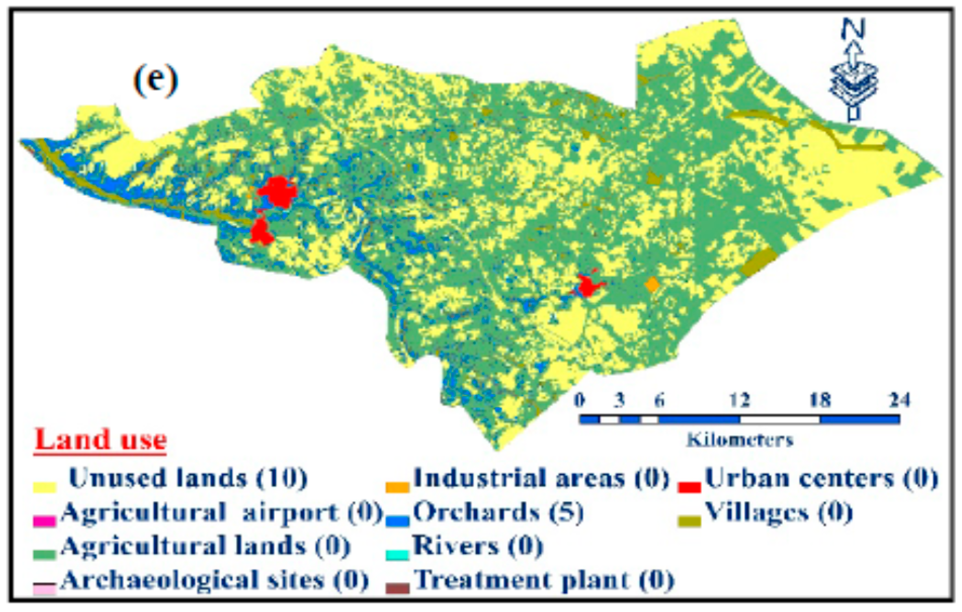
| 6 | Land use | Industrial Area | 0 | 0.0302 | 0.12 |
| Urban Centers | 0 | 0.93 | |||
| Villages | 0 | 3.15 | |||
| Treatment plant | 0 | 0.0002 | |||
| Rivers | 0 | 0.35 | |||
| Archaeological | 0 | 0.003 | |||
| Agri. land | 0 | 53.15 | |||
| Orchards | 5 | 7.752 | |||
| Unused land | 10 | 34.544 | |||
| Agri. airport | 0 | 0.0008 | |||
| 7 | Agricultural land use | Agricultural land | 0 | 0.0462 | 55.74 |
| Orchards | 5 | 8.32 | |||
| Unused land | 10 | 35.94 | |||
| 8 | Roads (m) | 0–500 | 0 | 0.0463 | 15.2 |
| 500–1000 | 7 | 12.76 | |||
| 1000–2000 | 10 | 19.18 | |||
| 2000–3000 | 5 | 15.94 | |||
| >3000 | 3 | 36.92 | |||
| 9 | Railways (m) | 0–500 | 0 | 0.0107 | 2.15 |
| >500 | 10 | 97.85 | |||
| 10 | Urban centers (km) | 0–5 | 0 | 0.1471 | 24.23 |
| 5–10 | 10 | 34.74 | |||
| 10–15 | 7 | 26.01 | |||
| >15 | 4 | 15.02 | |||
| 11 | Villages (m) | 0–1 | 0 | 0.1038 | 44.9 |
| >1 | 10 | 55.1 | |||
| 12 | Archaeological sites (km) | 0–1 | 0 | 0.0302 | 6.95 |
| 1–3 | 5 | 49.5 | |||
| >3 | 10 | 43.55 | |||
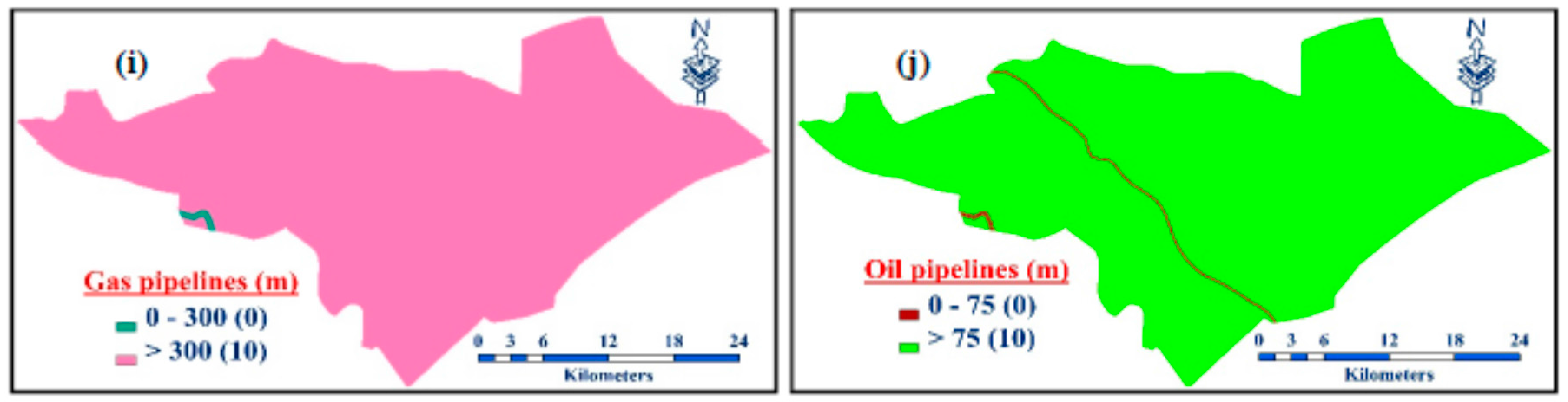
| 13 | Gas pipelines (m) | ≤300 | 0 | 0.0146 | 2.89 |
| ˃300 | 10 | 97.71 | |||
| 14 | Oil pipelines (m) | ≤75 | 0 | 0.0146 | 5.93 |
| ˃75 | 10 | 94.07 | |||
| 15 | Power lines (m) | ≤30 | 0 | 0.0207 | 3.05 |
| ˃30 | 10 | 96.95 |
| n | 1 | 2 | 3 | 4 | 5 | 6 | 7 | 8 | 9 | 10 | 11 | 12 | 13 | 14 | 15 |
|---|---|---|---|---|---|---|---|---|---|---|---|---|---|---|---|
| RI | 0 | 0 | 0.58 | 0.9 | 1.12 | 1.24 | 1.32 | 1.41 | 1.45 | 1.49 | 1.51 | 1.48 | 1.56 | 1.57 | 1.59 |
© 2017 by the authors. Licensee MDPI, Basel, Switzerland. This article is an open access article distributed under the terms and conditions of the Creative Commons Attribution (CC BY) license (http://creativecommons.org/licenses/by/4.0/).
Share and Cite
Chabuk, A.; Al-Ansari, N.; Hussain, H.M.; Knutsson, S.; Pusch, R.; Laue, J. Combining GIS Applications and Method of Multi-Criteria Decision-Making (AHP) for Landfill Siting in Al-Hashimiyah Qadhaa, Babylon, Iraq. Sustainability 2017, 9, 1932. https://doi.org/10.3390/su9111932
Chabuk A, Al-Ansari N, Hussain HM, Knutsson S, Pusch R, Laue J. Combining GIS Applications and Method of Multi-Criteria Decision-Making (AHP) for Landfill Siting in Al-Hashimiyah Qadhaa, Babylon, Iraq. Sustainability. 2017; 9(11):1932. https://doi.org/10.3390/su9111932
Chicago/Turabian StyleChabuk, Ali, Nadhir Al-Ansari, Hussain Musa Hussain, Sven Knutsson, Roland Pusch, and Jan Laue. 2017. "Combining GIS Applications and Method of Multi-Criteria Decision-Making (AHP) for Landfill Siting in Al-Hashimiyah Qadhaa, Babylon, Iraq" Sustainability 9, no. 11: 1932. https://doi.org/10.3390/su9111932