Article

Using the Concepts of Green Infrastructure and Ecosystem Services to Specify Leitbilder for Compact and Green Cities—The Example of the Landscape Plan of Dresden (Germany)

1
Leibniz Institute of Ecological Urban and Regional Development, Weberplatz 1, 01217 Dresden, Germany
2
State Capital of Dresden, Environmental Office, P.O. Box 120020, D-01001 Dresden, Germany
*
Author to whom correspondence should be addressed.
Sustainability 2017, 9(2), 198; https://doi.org/10.3390/su9020198
Submission received: 24 November 2016 / Accepted: 24 January 2017 / Published: 1 February 2017
(This article belongs to the Special Issue Maintaining Ecosystem Services to Support Urban Needs)

Abstract

:
In the light of ongoing global urbanization and the high pace of resource consumption, there is an urgent need to foster compact cities. Currently, however, we lack integrative guidelines on how to manage trade-offs between urban densification and the provision of green space. Against this background, this study applies the concepts of green infrastructure and ecosystem services to develop a guideline for landscape planning to foster compact and green cities. The guideline was tested on the example of the landscape plan of Dresden (Germany), which foresees a compact city in a green network. Results show that the concepts of ecosystems services and green infrastructure can support urban practitioners in structuring the complex interrelations between landscape planning and compact and green cities. The developed guideline provides an integrative framework for modular landscape planning that: (1) reflects the spatial heterogeneity and properties of urban ecosystems and landscapes; and (2) considers cities as integrated socio-ecological systems. The case study indicates that a more comprehensive perspective of cities and their ecosystem is required, one that connects green with grey infrastructure. Further research should focus on how the green infrastructure concept can be refined to incorporate strategic planning for compact cities.

1. Introduction

One of the most pressing social challenges is the ongoing global process of urbanization, resulting in the degradation of urban ecosystem services and the loss of certain benefits to residents generated by urban nature [1,2]. Urban sprawl is undermining the “ecology in the city” [3], including natural and semi-natural areas, e.g., forests or wetlands [4,5]. For instance, urban sprawl can fragment natural habitats such as of forest cover [6], thereby negatively impacting on wildlife. The food supply is also threatened by urban sprawl when ex-urban growth destroys high quality soils [7]. To reduce such negative ecological and environmental impacts as well as social (e.g., over-reliance on cars) and economic repercussions (e.g., higher per capita infrastructural costs) of urban sprawl, policymakers and scientists are calling for the promotion of a more sustainable urban form, namely compact cities [4,5,8]. Although policies favoring the compact city include multi-dimensional objectives to secure sustainable development, the main aim of compact cities is to protect the environment from further degradation by urban sprawl [5].
To succeed, the concept of the compact city requires an integrative approach to ecological and environmental sustainable development, one that reflects trade-offs between densification and the quantitative/qualitative supply of green spaces within urban developed areas [9]. Such an integrative view is vital since ecosystem services (and thus urban green spaces as the most important supplier of ecosystem services) are most effective when located close to areas which require them [10]. Clearly, the ecosystem benefits for the mental and physical health of residents are maximized when urban green areas are located at short distances from local housing [11,12]. However, a case study in Barcelona (Spain) showed that the demand for ecosystem services such as cleaner air and outdoor recreation sites is largely unsatisfied in core urban areas because these services are mainly supplied by peri-urban green areas [13]. This imbalance between the supply of ecosystem functions and demand for ecosystem services is intensified when compact cities are fostered and urban green spaces are lost due to infill development and densification processes.
In general, greater effort is required to establish integrative urban monitoring concepts which reflect the ecology of the city. These must take into account built and (semi-)natural structures as well city stewardship by urban actors while considering the interactions between biophysical, social as well as governance structures and processes [3,14]. Such monitoring concepts are vital to determine how a qualified urban infill development can be implemented to create compact and green cities [8]. To this end, landscape ecological approaches for green structures (e.g., connectivity, patch structure), governance processes (e.g., consideration of multiple functions of urban green spaces and its benefit for human well-being) as well as public participation (e.g., adaption of green spaces to demands of residents) are required for the integrative urban green space planning of compact and green cities. A recent review of green spaces and densification has highlighted the need to identify such successful policies, which aim at preventing green space degradation during compaction and enable development of multi-functional urban green spaces [9].
Some scholars argue that the concept of green infrastructure should promote multi-functional green spaces and their integration into the grey infrastructure [15,16]. Multi-functionality can also be considered as the capacity of green infrastructure to supply multiple ecosystem services [16]. The multifunctional and multiscale aspects of green infrastructure are intended to strengthen connections between different types of green space as well as with the grey urban infrastructures (e.g., built-up land) [17,18]. The concept is advocated by the European Commission [19], which suggests that green infrastructure can help promote compact cities, while a reduction in green infrastructure as a result of land take for settlement and transport areas can degrade ecosystem services [8]. Although the concepts of ecosystem services [14] and green infrastructure [8] are integrative tools to support planning and policy for sustainable urban land management, further effort is required to ensure their wider implementation in planning practice [20,21].
It is argued that land management and landscape planning are primary factors behind the development of land cover (e.g., sealed land through road construction or green spaces in the form of parks) and related types of land uses for human activities (e.g., roads or parks). Landscape planners can set general targets in urban development, for instance aiming for a compact urban development rather than urban sprawl. Through the spatial shaping of urban green infrastructure, landscape planning also strongly influences ecosystem properties, functions and their potential to supply ecosystem services for human well-being. Major aspects of landscape planning are voluntary cooperation and the supply of information about the condition and development options of the nature and the environment to state actors and civil society [20,22]. In the German-language planning literature, landscape planning is shaped by Leitbilder, which are argued to be valuable tools in setting visions and operations for actions to ensure sustainable landscape management. The Leitbild concept implies a transdisciplinary planning approach in which experts and laypersons elaborate strategies and goals for sustainable landscape planning. By considering the social dimensions of landscapes and by bringing together various groups of actors to develop common visions for spatial planning, Leitbilder can provide a strategic framework to deal more effectively with planning conflicts (e.g., compact vs. green urban development) not only in Germany but also around the world [23].
In view of the urgent need to establish compact and green cities, Leitbilder for landscape planning should reflect guidelines on how this complex target can be achieved. In Germany, the need to take into account a moderate densification while ensuring the sufficient quantitative and qualitative supply of green spaces areas is termed “dual infill development” [24]. This approach has already been implemented in planning practice and urban development strategies [8]. For instance, the landscape plan of Dresden (Germany) aims to realize a sustainable spatial development by promoting a compact city that incorporates a green network [25]. In addition, the Leitbild “compact urban green” is applied in the Bavarian capital Munich to foster the compact green city. However, urban planning in Munich is criticized for overly complex planning processes that constrain the implementation of dual infill development [26].
Considering the contradiction between the need for compact development on the one hand and urban green space on the other, we argue that the concepts of ecosystem services and green infrastructure are valuable approaches to concretize Leitbilder of landscape planning dealing with compact and green cities, their biophysical structures (in particular green space multi-functionality) and governance processes. Against this background, the objective of this paper is to develop a guideline on how landscape plans that obey the Leitbild of a compact and green city should be framed to reconcile the desire for green cities while considering the development aim of compact cities. Based on current research debates, this paper uses the concepts of green infrastructure and ecosystem services to develop and test such an integrative guideline for compact and green cities. We attempt to answer the following two research questions:
(1) How can the concepts of green infrastructure and ecosystem services support the conceptualization of compact and green cities in the course of Leitbild development within landscape planning under consideration of biophysical structures and governance processes?
(2) a. What will a guideline for landscape planning following the Leitbild of compact and green cities under consideration of biophysical structures and governance processes cities look like; and b. what is the value of its implementation?
To answer the first question, the theoretical basis for a guideline on landscape planning is conceptualized in Section 2 by drawing on relevant literature on urban ecosystem services and green infrastructure under consideration of its value for compact cities. Based on the findings, a guideline is developed in Section 3. The developed framework is tested on the case study of Dresden (Germany) and its landscape plan (research question 2), which follows the Leitbild “compact city in a green network”. The case study is explained in Section 3. Subsequently, the main results are presented and visualized by selected examples from the case study. The paper closes with a discussion of lessons learned as well as the main conclusions.

2. Green Infrastructure and Ecosystem Services Shaping Landscape Planning towards Compact and Green Cities

In Germany, there is a long tradition going back to the 1970s of introducing environmental concerns into planning. This is clear when one reviews landscape planning over the past decades. According to the Federal Nature Conservation Act (§ 11 BNatSchG), the municipal landscape plan must develop concrete targets, demands and measures related to nature conservation and landscape management. This is the ecological basis for urban land-use planning. These targets and measures of the landscape plan, which are integrated into the urban land-use plan, are binding for authorities. To ensure sustainable land management, landscape plans in Germany traditionally have to develop measures to secure the utilization and regeneration of primary natural assets, i.e., soils, the local climate, water, air, wildlife and biotopes, landscapes, humans, cultural goods. To this end, German landscape planning uses the concept of “landscape functions” to address landscape properties with the capacity to meet human needs (see our understanding of key terms in Box 1). In this way, landscape plans can be said to focus on the supply side of ecosystem services [27].
In the English-language literature, “ecosystem functions” (or “landscape functions”) are defined as goods and services provided by natural components and processes and which satisfy human needs directly or indirectly [28]. The landscape potential approach discussed in German landscape planning literature (for an overview see [20,29]) reflects the capacity of an ecosystem/landscape to provide services to potential users. Consideration of such ecosystems functions reveals society’s potential to make use of structures and processes provided by ecosystems and landscapes through various options for land use and resource development. Along with the capacity to deliver services, ecosystem and landscape properties also have inherent capacity to deal with risks and to recover from destruction [20]. In general, we can say that the focus of German landscape planning is the analysis and evaluation of values and functions of the landscape as well as natural assets. These are analyzed and assessed according to their relevance to achieve various goals such as the conservation of biodiversity, a higher potential and functional capacity of the natural environment and the improved experience and perception of nature and landscape by humans [30]. By considering ecosystem functions as ecological phenomena, it is argued that the analysis of ecosystem service supply in landscape planning is largely identical with the analysis of landscape functions [31]. In regard to regional and land use planning, functions are also viewed as tasks imposed on landscape and ecosystems, namely to provide services to humans [32].
However, the concept of landscape functions requires an integrative assessment and consideration of its beneficiaries if we are to view landscapes and ecosystems as socio-ecological systems [20,33]. Since such an integrative perception is particularly important for a landscape plan that aims to develop green and compact cities (see Section 1), we argue that this deficiency can be remedied by integrating the concepts of ecosystem services and green infrastructure into landscape planning. In so doing, the concept of green infrastructure can help landscape planners consider the socio-ecological aspects of land use development [15]. Integration of the concept of ecosystem services into landscape planning supports decision-makers in assessing the prospective distribution and quality of ecosystems and to take account of landscape changes (e.g., densification) that affect environmental qualities (e.g., a lack of ecosystem services in developed areas) [22,34].
The main principles in the planning of green infrastructure are related to green structure (multi-object approach, integration, connectivity, multi-functionality, and multi-scale approach) and governance processes (strategic approach, social inclusion, and transdisciplinarity) [16] and thus reflect the interactions between biophysical, social and governance structure and processes for the ecology in, of and for the city (see Section 1 and [3]). These principles are not only essential to help implement green infrastructure into the city but also provide guidelines for generating compact and green cities. Compact cities are distinguished by areas of high-density development unevenly distributed over the urban precincts [35]. These highly dense built-up areas contain demographically diverse populations [36]. Meanwhile, it is argued that residents of such dense areas are very often dissatisfied with the environmental and residential quality [37]. These deficiencies are linked to a lack of urban green space [9]. Sufficient supply of urban greenery is an important pre-condition for human health and well-being [38]. To address the lack of urban green space in compact cities, we argue for the application of a multi-object approach to green infrastructure planning. Within a multi-object approach, various kinds of blue and green areas can be planned for developed and undeveloped urban areas such as (private or public) forests and woodland, agricultural areas, urban parks (including playgrounds or golf courses), allotments, private gardens, cemeteries as well as streams or lakes [10,39]. By providing a variety of green spaces with various functions, it is possible to ensure that the diverse demands and preferences of urban residents for green spaces are met [38].
In regard to the supply of green spaces in developed urban areas, we see the integration of green infrastructure into the grey infrastructure as the next important principle in green infrastructure planning for compact and green cities. To increase the supply of urban green space, the green infrastructure concept suggests a physical or functional integration of green space into the planning of grey infrastructure such as transport networks or vacant plots [15,18,40].
To counteract the loss of green spaces within highly dense built-up areas, the third important aspect of green infrastructure planning for compact and green spaces is their connectivity in physical and functional terms. Specifically, this implies the interlinking of separate green spaces within developed urban areas as well as with relatively undisturbed green areas in less densely built-up areas. For instance, urban ecological networks created through green fingers and stepping stones can support the connections between and supply of habitats, thereby safeguarding biodiversity [41]. Moreover, green networks developed alongside roadways increase local residents’ access to green spaces by promoting walking or biking as alternative travel modes [15]. The interconnection of green infrastructure also improves the air quality in compact cities by facilitating the circulation of fresh air from rural to urban areas [42].
The examples related to connectivity also highlight the potential of green infrastructure to combine various social and ecological functions. This aspect of multi-functionality is a key characteristic of green infrastructure planning [17,18] and can be regarded as a vital step in achieving compact and green cities. Multi-functional green spaces maximize benefits for residents while compensating for the limited extent of such urban greenery [43]. The interlinking of green spaces can be supported by local measures (e.g., through environmental stewardship organizations taking responsibility for roadway and riparian corridors [44]) or by national and international regulations (e.g., the European transnational Natura 2000 network [45]). Clearly, green infrastructural planning needs to adopt a multi-scale approach that involves not only individuals and communities but also actors at the regional and state level [16].
Such multi-scale planning is also of great importance in securing green spaces as a protection against further urban soil sealing (and thus supporting compact and green cities) [8]. Therefore, we see the aspect of multi-scale action not only in relation to an integrated green structure planning but also as a principle for urban green infrastructure governance. A further governance principle is social inclusion as a participative planning approach [16]. On the one hand, such an open planning process for compact and green cities can be in the form of a direct participative planning process that engages residents to integrate green into the grey infrastructure. For example, local residents can be encouraged to plant green roofs or generate green space on underused paved sites [46]. An inclusive planning can also engage residents indirectly by considering the demands of different population groups such as the elderly or children for green space. This also helps to reflect the various interests of a diverse population in the compact city. Strategic green infrastructural planning also benefits from a transdisciplinary planning approach, thereby exploiting a wide range of expertise from different stakeholders. This is important, for example, when integrating green space into grey infrastructure in compact and green cities through green roofs, a process requiring engineers to collaborate with environmental and urban development planners [8]. In general, green infrastructure planning must be responsive to changing local framework conditions [16]. A strategic approach to realize compact and green cities should reflect the contribution of green infrastructure to limit urban sprawl. For example, regional greenbelts are promoted in Germany as an effective measure to preserve open space [47].
In this regard, it is worth emphasizing that high quality green space offering multiple ecosystem services can play a vital role in securing manifold ecological and social benefits [16]. The concept of ecosystem services can be an integrative tool to help plan, develop and manage urban green spaces in compact cities [9]. Since the objectives of landscape planning may conflict with the aims of urban authorities to expand built-up areas and boost the local economy, great persuasion is needed to protect urban green spaces. In this regard, landscape planning can be supported by monetary and non-monetary accounting of ecosystem services as well as by emphasizing the multi-functionality of landscapes and their broad range of ecosystem services [34]. Moreover, the concept of ecosystem services specifies particular social benefits provided to local residents, thus linking beneficiaries with ecological assets stated in landscape planning (see Section 1). This counterbalances the lack of consideration given by landscape planning to the demand for ecosystem services [48]. The interplay between supply and demand makes the concept of ecosystem services a powerful tool in developing compact and green cities [49]. However, urban planning in the US and Europe still makes limited use of ecosystem services [21,34]. Germany’s regional and landscape planners criticize the concept by arguing that existing tools of landscape planning already provide almost all needed environmental information and that additional concepts only serve to increase the complexity and costs of planning [34].
In attempting to answer research question 1, we conclude that the currently discussed concepts of ecosystem services and green infrastructure can help to guide landscape planning towards compact and green cities by reflecting the socio-ecological complexity of cities. They suggest ways to retain urban green spaces within urban densification processes by focusing on spatial structure, governance processes and multi-functionality as key aspects of integrative urban green space planning (see Section 1).
Box 1. Definitions of key terms.
Landscape planning: In Germany, landscape planning is implemented at various scales. The German Federal Nature Conservation Act demands at least a two-stage landscape planning process including the regional level (landscape structure plan) and local level (landscape plan). The focus of this study is the local level, specifically the city of Dresden. The landscape plan is a sectoral plan which addresses environmental issues at municipal level. It aims to secure the provision of landscape functions by gathering and assessing spatially explicit data on environmental capacities. The plan specifies nature conservation objectives and related management guidelines [30,34].
Urban green space: The term usually encompasses all areas of vegetation found within a city including parks, allotments, residential gardens or roadside trees [50].
Green infrastructure: According EU terminology, green infrastructure is “a strategically planned network of high quality natural and semi-natural areas with other environmental features” including blue infrastructure (e.g., streams, lakes) [19]. The main principles of green infrastructure planning are related to green structure (integration, connectivity, multi-scale and multi-object approach, multi-functionality) and governance processes (strategic approach, social inclusion, transdisciplinarity) [16].
Compact city: This term is typically defined in opposition to urban sprawl. It is an influential urban design concept whose guiding principles include high residential density and the discouragement of private car use.
Compact and green city: This term emphasizes consideration of urban green space within urban compact development, and is sometimes called “dual infill development”.
Functions of ecosystems/landscapes: Reflecting common usage in German landscape planning, we define such functions as biophysical processes and structures, natural assets and potentials provided by natural components of the ecosystem and landscape.
Services of ecosystems/landscapes: These include currently utilized or demanded services of the ecosystem or landscape which benefit human life and well-being [20].
Urban ecosystem/landscape functions and services: These are ecosystem or landscape functions and services related to cities and other urban areas.

3. Developing and Testing a Landscape Planning Guideline to Foster Compact and Green Cities

3.1. Developing a Landscape Planning Guideline

Based on the preceding discussion, in the following section we develop a guideline for landscape planning which proposes the Leitbild of the compact and green city to steer urban development (see research question 2a). The guideline mirrors the three main targets of landscape planning, namely: (1) the analysis and assessment of urban landscapes and the environment; (2) the specification of planning targets and related implementation measures; and (3) the impact analysis of planning targets and measures [29]. The developed guideline suggests that each of the three modules should reflect the Leitbild of a compact and green city by considering: (1) green structures of compact urban development as part of green infrastructure planning for the ecology in and of the city; (2) governance processes to promote ecology for the city in terms of green infrastructure for a compact and green city (see Table 1 and Table 2); and (3) multi-functionality of green infrastructure reflected by the provisioning of multiple ecosystem functions (see Table 3).
To facilitate the multi-object approach of green infrastructure planning to foster compact and green cities, we suggest that different types of green spaces be considered at various planning levels [51,52]. In this way, it is possible to monitor the types of green space targeted by landscape plans within developed areas at site scale as well as in undeveloped areas at city scale. Such multi-scale aspects can even reflect green space development at regional or national levels. To allow a close integration of green into grey infrastructure at site scale, green types are further distinguished by considering the built environment (in terms of integration) and green space types found in developed areas (in terms of site scale) (see Table 2).
To ensure that landscape planning considers the multi-functionality of green infrastructure, the ecosystem service approach is applied in shaping the guideline. In this regard, it should be noted that analysis of the uptake of ecosystem services into planning practice is constrained by local differences in terminology. This is also true for Germany, where the German equivalents for landscape or ecological functions are regularly used in planning documents. In contrast, there is frequently no explicit reference to ecosystem services, even though benefits to local residents provided by functions are referred to implicitly [21]. Therefore, the guideline refers to ecosystem functions rather than to ecosystem services (see Table 1) (also including objects of protection and potentials of ecosystems and landscapes; see Box 1). The main categories of ecosystem service analyzed in planning discourses dealing with the green infrastructure planning and multi-functionality of European and American cities include provisioning (material outputs provided by the ecosystem), regulation (ecosystem processes that serve to regulate the ecosystem), habitats (functioning as living spaces and maintaining genetic diversity in support of biodiversity) and cultural ecosystem services (non-material benefits for local people who engage with the ecosystem [21]. These categories are also the focus of this study (see Table 3).

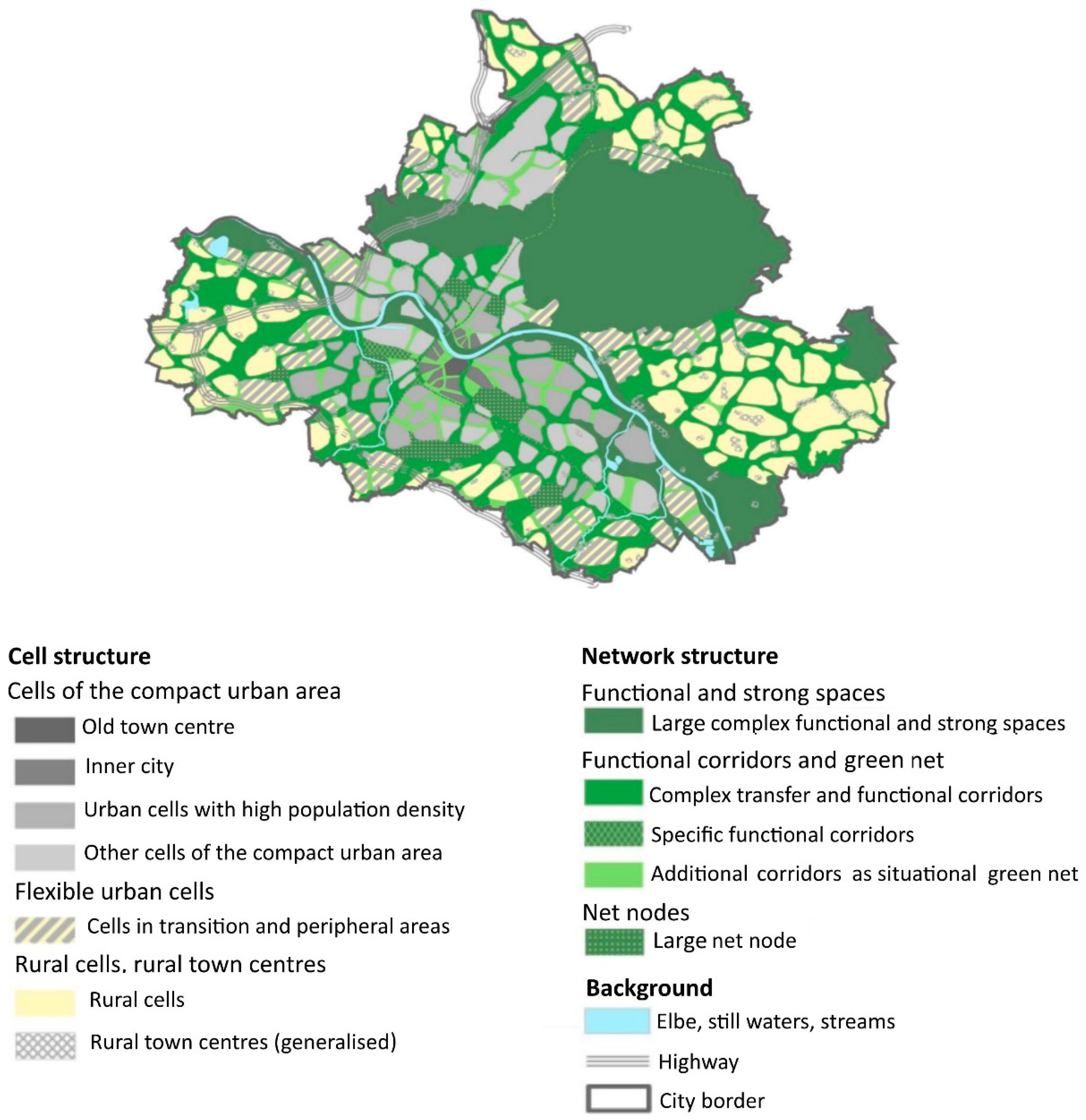
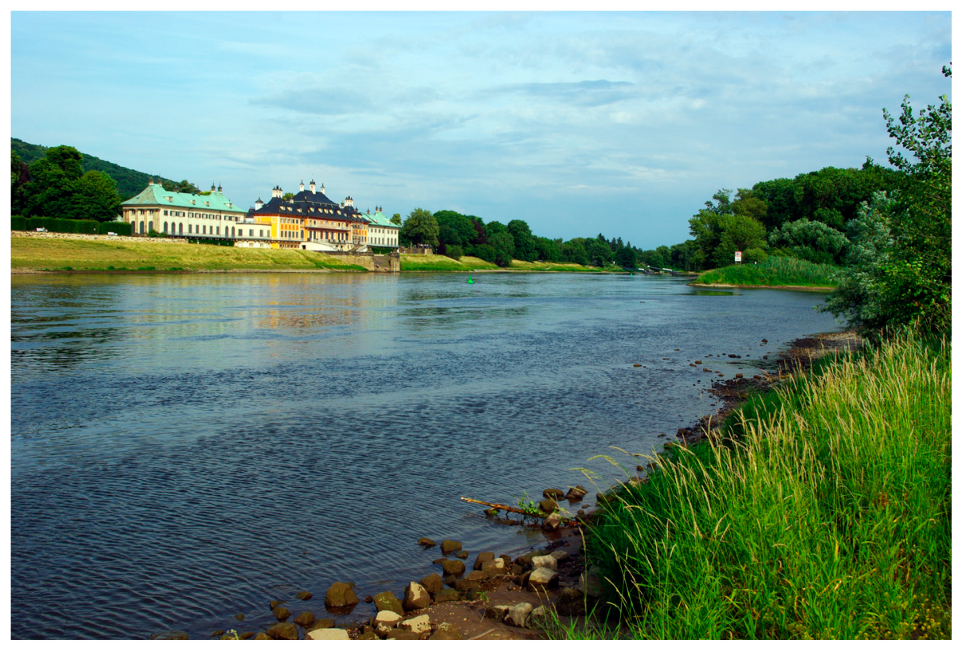
3.2. Testing the Guideline in a Case Study of Dresden (Germany)

To test the value of the developed guideline (see research question 2b), we performed a qualitative content analysis of an exemplary landscape plan. The analysis of urban planning policies and strategies (e.g., dealing with green or grey infrastructure as well as comprehensive plans) can contribute to an understanding of policy paradigms within a given period [21]. The city of Dresden (Germany) and its landscape plan was selected for the case study as this landscape plan includes an innovative Leitbild, namely “Dresden—the compact city in the ecological network”, which focuses on achieving sustainable urban development by fostering a compact and green city. In analyzing the landscape plan, the developed guideline (see Table 1) serves to excerpt relevant data. The analysis is supplemented by selected examples in order to show the practical implementation of Dresden’s strategy.
Dresden is the capital city of the federal state of Saxony, located in the east of Germany. With a total area of 328 km2, the population in 2015 was approximately 544,000. Projections show that the number of households will increase from 292,249 in 2013 to 310,000 by 2025 [53]. The city is embedded between the foothills of the Eastern Ore Mountains, the Lusatian granite slab and the Elbe Sandstone Mountains (German: Elbsandsteingebirge). Highly disparate landscapes can therefore be found within the city precincts. Dresden’s landscape is shaped by the Elbe River, with broad floodplains mostly in the form of semi-natural meadows crossing the entire city from southeast to northwest. The inner city has extensive green space in the form of parks and avenues as well as many small habitats of partly rare and threatened plants and animals. Large forested areas can be found in the northern and eastern fringes. Agricultural land and sparse woodland predominates in the west and south of the city. Dresden possesses a range of urban green areas such as nature and landscape conservation areas, parks, allotments and cemeteries [25].
The current challenges for the city’s urban development are determined by past and future re-urbanization processes, whereby the main demographic challenges are to supply sufficient housing for a growing population and to adapt to the particular needs of the increasing number of elderly residents. The focus of development is therefore on urban infill development and the creation of new housing in the inner-city as well as the revitalization of brownfields (a legacy of economic contraction) to counteract processes of urban sprawl. Recognizing the importance of urban greenery for sustainable urban development [53], the local authorities have stated that future urban development will encompass the protection and expansion of green spaces.
Reflecting the need to foster a compact city as well as incorporate green infrastructure within urban development, the current draft of Dresden’s landscape plan has been drawn up under the Leitbild “Dresden—the compact city in the ecological network” (German: “Dresdendie kompakte Stadt im ökologischen Netz”) [25]. Within the landscape plan, the Leitbild is realized by dividing the city precincts into sub-areas for which environmental functions are analyzed. The ecological network is framed by a net structure (including functional spaces and high value spaces, functional corridors and green nets as well as net nodes) and a cell structure (including cells of the compact urban area, flexible urban cells and rural cells) (see Figure 1). Together these define a net consisting of functional spaces, corridors, nodes and green connecting axes, mirroring the existing features of the natural landscape as well as the polycentric design of Dresden. It is worth mentioning that the net does not include officially designated zones or protected areas but rather can be regarded as a guide for landscape planning and future land use. To provide further in-depth recommendations for land-use planning to protect and/or develop the sub-areas, 27 measures are elaborated for inclusion in the landscape plan and which provide orientation for further planning by other urban departments (see Box 2) [25].
The landscape plan consists of a main text and an appendix (including plans and maps). The text is divided into three parts: (A) a general section describing the tasks and targets of the landscape plan and presenting the strategic environmental assessment as well as the target area; (B) an analytical section describing and assessing the environmental status based on the objects of protection; and (C) a planning section introducing the Leitbild, its embedded concept of measures and development and likely environmental impacts. The analysis and assessment of the natural environment and landscapes as well as the proposed measures are based on the following objects of protection: soil, water, climate, species and biotopes, landscape, humans and cultural goods.
In analyzing the landscape plan, we made use of parts relevant to: (I) evaluation of nature and landscape; (II) planning targets and measures; and (III) planning impacts (see Table 1). For the evaluation of nature and landscape, we considered the analytical section of the text as well as the appendix. Data on planning targets and measures correspond to the planning section of the landscape plan. To analyze planning targets, we made use of the report on the Strategic Environmental Assessment of the landscape plan, added as appendix to the landscape plan (every landscape plan must be subject to a Strategic Environmental Assessment according to §3 para. 1a No. 2 SächsUVPG). The appendix of the plan can be viewed online (www.dresden.de/de/stadtraum/umwelt/umwelt/landschaftsplan/unterlagen_landschaftsplan.php).
Box 2. Planning measures (M) of Dresden’s landscape plan [25].
M1: Extension of areas currently used for agriculture/horticulture
M2: Measures for erosion prevention on land with high risk of erosion
M3: Enrichment with small structures
M4: Permanent maintenance and enhancement of habitat structures
M5: Maintenance and restoration of habitats for ground-nesting birds
M6: Extensive use of permanent grassland
M7: Development of permanent grassland
M8: Development or restoration of orchard meadows
M9: Development of tree rows, coppices, corridor woods (hedges) or other woodland sites
M10: Development of a layered woodland border
M11: Afforestation
M12: Opening of allotments, development of allotment parks
M13: Development or restoration of green and recreational areas
M14: Restoration or improvement of ecological functions of the headwater region
M15: Restoration or improvement of the ecological functions of standing waters
M16: Restoration or improvement of the ecological functions of running waters
M17: Preservation and development of a high level of greening in hillside development
M18: Adapting village borders and development to the surrounding landscape
M19: Local actions to improve the urban climate
M20: No further development in sensitive areas
M21: De-sealing, demolition of buildings, removal of deposits
M22: Protective measures on roadways for amphibians
M23: Maintenance and restoration of migration corridors for amphibians
M24: Preventive examination of species populations before implementing measures of the landscape plan
M25: Conservation and development of the ecological network and habitat networks
M26: Conservation and development of the green network
M27: Conservation and development of trails

4. Adoption of the Green Infrastructure and Ecosystem Service Approach by the Landscape Plan Dresden

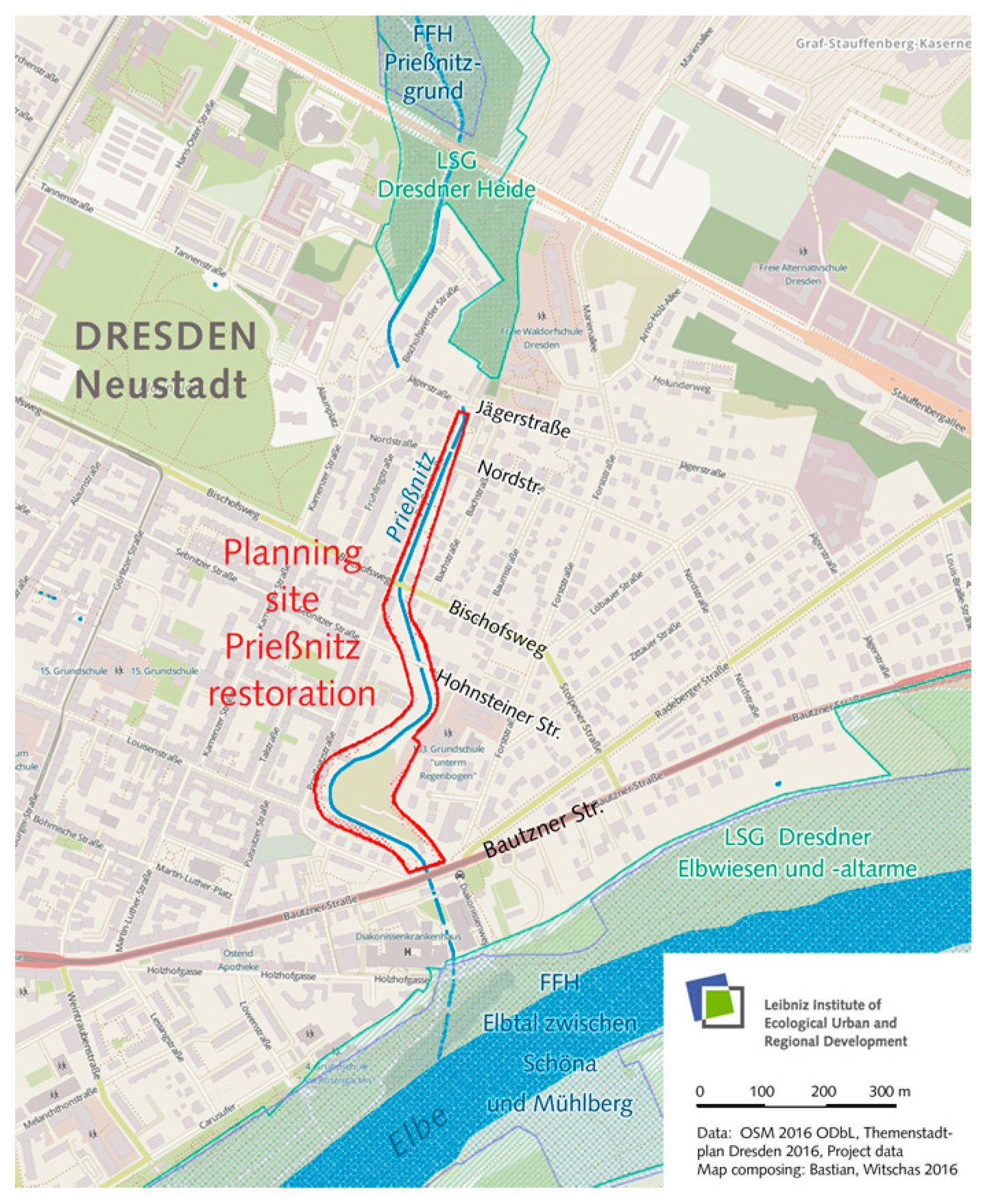
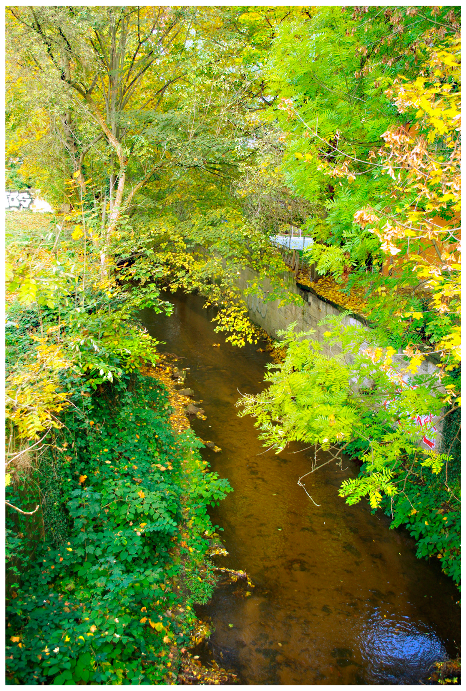
4.1. Consideration of Green Structures within Landscape Planning for Compact and Green Cities

Analysis of the natural environment and landscapes within the landscape plan is based on seven issues of protection. To assess their performance, a range of green infrastructure objectives is considered, primarily at the city/district scale. Various green objectives are considered for the assets types: species and biotopes, landscape and humans (see Table 4). The main green infrastructure objects at city scale are agricultural land, forests and forest parks as well as rivers and floodplains. One method to analyze the status of the natural environment and landscapes is to draw up an urban biotope map for Dresden reflecting all three types of assets (species and biotopes, landscapes and humans). This map includes a range of various green infrastructure objectives, assessed for their potential to support diverse species, their substitutability and degree of naturalness (species and biotopes), their potential for recreation (humans) and visual features of the landscape. Green infrastructure also plays a major role in analyzing the local climate. Here analysis was undertaken by developing a map of climate functions. However, the map does not reflect different green types but rather is based on green volume. For the assets “landscape” and “humans”, the regional green infrastructure scale is also considered such as the open countryside in terms of the visual axes of the Elbe valley. The aspect of integration of green infrastructure was largely not included in the analysis of the state of the natural environment and landscapes. Connectivity was considered indirectly in terms of species and biotopes, specifically through analysis of the numbers and sizes of protected landscape components and Fauna-Flora-Habitat (FFH) areas (see Box 4, Section 4.2), thereby investigating conservation measures and the development of habitat networks (coherence). For the asset “humans”, connectivity was assessed through the interlinking of recreational spaces. The analyses of the natural environment and landscapes looked closely at the multi-functionality characteristic of green infrastructure planning (see Table 5).
Comparing the analytical section of the landscape plan with specific planning proposals, some planning targets and measures are seen to focus on ecosystem functions which are not reflected in the analytical section of the landscape plan and vice versa (see Table 5). Comparing all three sections of the landscape plan, the planning section best reflects a broad diversity of ecosystem functions. In particular, more types of cultural ecosystem functions are mentioned for planning targets and measures than in the analytical section. For instance, the goal of measure M27 (Conservation and development of trails) is not only to increase the recreational function of trails but also to restrict tourists to specific paths. Moreover, this measure has an additional aim: to contribute to nature experience and education alongside the promotion of health and recreation. The ecosystem functions primarily targeted in the planning section are the safeguarding of habitats, followed by recreation, improvement of the local climate and regulation of air quality. The multi-functionality of the measures is particular reflected by M1 (Extension of areas currently used for agriculture/horticulture). This measure considers nine functions that are primarily regulatory, i.e., local climate and air quality regulation, carbon sequestration, moderation of extreme weather events and erosion prevention and maintenance of soil fertility. The achievement of synergies by this measure is also explicitly mentioned within the landscape plan, which emphasizes the fact that an improved local climate, biological control and soil protection can have positive impacts on agricultural yields.
The issues of connectivity and integration are also reflected in separate planning measures. Connectivity was explicitly reflected in M25 (Conservation and development of the ecological network and habitat networks) and M26 (Conservation and development of the green network), which aim to protect and develop green networks. Although the focus of connectivity is on green networks, some measures also consider green-blue and blue networks to improve habitat connectivity and increase qualities for recreation, and thus contribute to multi-functionality (see Box 3). Measures of integration are explicitly adopted in the form of de-sealing and demolition of buildings (M21), particularly agricultural and military constructions. Moreover, measures dealing with habitat protection aim to integrate green space along railway lines and roads, confirming a close link between aspects of integration and the connectivity of green infrastructure. Generally, the planning measures neglect green infrastructure objectives at the regional scale. These are, however, given some consideration in the analysis section. The focus of the planning measures is clearly at site scale, in contrast to the analysis section of the landscape plan (see Table 4).
Box 3. The Prießnitz restoration project as an illustration of green-blue connectivity and multi-functionality.
The restoration of degraded small-scale river ecosystems is an important step in upgrading green infrastructure within urban areas and improving biodiversity, ecosystem services and human well-being. On the one hand, urban areas rely greatly on the services provided by natural ecosystems within and beyond their borders, particularly water ecosystems. In light of the increasing pace of urbanization, it is vital the natural environment be safeguarded and promoted within urban areas. At the same time, human activity is placing pressure on fragile water ecosystems around the world, especially in urban and suburban settings. Anthropogenic pollution, regulation of watercourses, changes in the catchment areas, and riverine habitat alterations are some of the most severe burdens afflicting urban water ecosystems.
In accordance with the EU Water Framework Directive, which was designed to harmonize the legal framework of water policy in the European Union, the landscape plan of Dresden seeks to maintain and implement a network of watercourses (including their riverbanks and adjacent green spaces) as a city-level spatial network, specifically an aquatic/semi-terrestrial biotope compound system. Core targets are a healthy ecology, clean water and wildlife passability but also a high esthetic quality, potentials for landscape experience and the optimization of ecosystem services in the sense of multi-functionality.
During the last few years, the city of Dresden has made great efforts to restore urban watercourses. In 2018, work will begin on restoring the Prießnitz river, for which detailed planning is almost completed. While the area around the source of the 25 km-long Prießnitz as well as its upper course have a close-to-nature character, the lower course runs along an artificial channel through the heavily sealed and densely populated Neustadt district of Dresden (see Figure 2 and Figure 3). Here the Prießnitz is practically inaccessible, and there is little chance of noticing the river within the densely built up surroundings.
The restoration project aims to improve the ecological status as well as reduce the risk of flooding. There is a special focus on improving public access to the river, local recreation facilities, flood protection as well as green infrastructure. The list of expected benefits of the restoration project includes:
  • New attractive green and recreational areas for the public with direct public transport connections;
  • Natural flood retention to prevent damage from severe flooding of the Prießnitz;
  • Development of floodplains as part of a habitat network for flora and fauna; and
  • Closing a gap in the ecological network of Dresden and improving the quality of the green infrastructure.
Since the impact of planning measures is evaluated in terms of protection objectives rather than different kinds of green infrastructure types, Table 4 reveals a lack of consideration of multi-object aspects within this section compared to the sections dealing with the analysis and planning measures. However, impacts on green infrastructure types by planning measures directly linked to different types of green infrastructure (e.g., to urban rivers or lakes, M15 and M16) are clearly reflected. Moreover, the integration of green infrastructure is reflected in the impact section. For instance, M19 (Local actions to improve the urban climate) includes estimations of the level of greening within developed areas. When restoring built-up areas such as industrial, commercial and transport areas under M21 (De-sealing, demolition of buildings, removal of deposits), a total of 0.72% of the urban territory is positively affected, for example by promoting transfer functions such as improved air exchange and flood water containment. Since connectivity is also stated as a separate protection concern, related measures are also evaluated in this regard. In general, the impact analysis of planning measures on ecosystem functions is descriptive rather than quantitative. Nevertheless, a range of ecosystem functions is mentioned in the impact section (see Table 5). In particular, M1 (Extension of areas currently used for agriculture/horticulture) takes into account a wide range of impacts on ecosystem functions, e.g., food supply, local climate and air quality regulation, moderation of extreme weather events, biological control and recreation. In contrast, no impacts on ecosystem functions were analyzed for six measures out of 27.

4.2. Consideration of Governance Processes within Landscape Planning for Compact and Green Cities

The multi-scale aspect is taken up in all three sections of the landscape plan. However, a broad evaluation of various regulations and laws at different scales (EU, national, federal and regional) was largely undertaken in the analysis section, assessing their relevance for the objectives of protecting green space and limiting urban sprawl. Within the sections on planning measures and their impact, the multi-scale uptake was more unstructured. Here only a few foci considered the role of regulations in dealing with water, its quality and floods (e.g., European Water Framework Directive, regional plan) as well as biodiversity by highlighting the European Natura 2000 directives as an example of multi-scale regulations and spatial implementations contributing to connectivity (see Box 4). A strategic approach that considers the contribution of green infrastructure in managing urban sprawl is presented in the sections on planning measures and their impact. Measures for the containment of built-up land while fostering green infrastructure target the implementation of green breaks or forest protection at the same time as new developments are curbed in sensitive areas. The impact analysis also looks into the repercussions of measures to limit urban sprawl. However, a descriptive evaluation of the impacts on urban sprawl is only considered for four measures: M3: Enrichment with small structures, which is believed to reduce development trends of urban sprawl; M9: Development of tree rows, coppices, corridor woods (hedges) or other woodland sites, assessed as reducing the visual effect of sprawl; M11: Afforestation, which reduces the visual effect of sprawl; and M26: Conservation and development of the green network, evaluated as not helping to reduce development trends of urban sprawl.
Regarding the aspect of social inclusion, a range of actors dealing with land development is considered in the first and second sections of the landscape plan. In particular, farmers and NGOs are mentioned as actor groups seeking to implement measures to preserve landscapes. Local residents are also viewed as active in the implementation of climate measures, for example by greening private courtyards. However, analysis of the impact of planning measures does not consider separate groups in the population but rather the general impact on health, recreation and the sense of place. The first two sections of the landscape plan also reveal a transdisciplinary approach involving sectoral plans as well as studies by architects and scholars analyzing the state of nature and landscapes. Scientific references are sometimes used in developing planning measures such as Gill et al. (2007), which provides evidence on the microclimate regulatory impact of urban green space on neighboring areas [54]. No transdisciplinary aspect is considered in the third section of the landscape plan, i.e., the analysis of impacts.
Box 4. Natura 2000 in Dresden as an example of multi-scale regulations contributing to green infrastructure connectivity.
One of the main functions of green infrastructure in cities is to maintain or enhance biodiversity. The conservation of biodiversity at all levels is a primary goal of international environmental policy. This also applies to cities. Thus, the German National Strategy on Biological Diversity refers explicitly to urban areas [55].
Settlements can host important substitute habitats for various threatened species from natural and cultivated landscapes. The protection of biodiversity in urban areas must encompass all categories of landscapes from the remnants of natural landscapes (e.g., near-natural forest), cultivated landscapes (orchards), urban-industrial areas as well as rural settlements and landscaped areas.
Nature reserves and natural monuments can even be located within the administrative borders of cities, such as the Natura 2000 network of protected areas in the European Union. Natura 2000, which is one of the world’s most ambitious biodiversity conservation projects, considers two basic categories of protected area: Fauna-Flora-Habitat (FFH) sites and Special Protection Areas (SPA) for birds.
For example, the FFH site Prießnitzgrund covers 224 ha of the valley of the upper Prießnitz river in Dresden (see Box 3). This valley is home to various strictly protected species, including several dragonfly species (Ophiogomphus cecilia, Leucorrhinia pectoralis), butterfly species (Euplagia quadripunctaria (Figure 4), Phengaris nausithous), cyclostomes (Lampetra planeri) and species of bats (Barbastella barbastellus, Myotis myotis). The following FFH habitat types can also be found: No. 3260—Natural and near-natural watercourses with floating aquatic vegetation; No. 91E0*—Alluvial forests with Alnus glutinosa and Fraxinus excelsior, 9110—Luzulo-Fagetum beech forests; No. 9160—Sub-Atlantic oak-hornbeam forests (Stellario-Carpinetum), as well as some others.
The Natura 2000 sites are part of the biotope compound system (biotope network) foreseen in the landscape plan of the city of Dresden (see Figure 5). This network is also intended to enhance the coherence of the Natura 2000 sites. According to the landscape plan, the biotope network aims to safeguard the native plant and animal populations including their habitats and functioning ecological relationships for the years to come. The biotope network includes core areas (esp. protected sites), linear linked corridors for wildlife migration and genetic exchange. Actions outlined in the landscape plan to strengthen the biotope connections include measures (e.g., M24 or M25; see Box 2) to:
  • Protect and develop large forests as well as woods in open landscapes and along natural watercourses;
  • Revitalize piped watercourses;
  • Maintain and utilize large grassland areas, e.g., as habitats and resting places for birds;
  • Enrich cleared agricultural landscapes with small linear and point-like habitat structures including edges and stepping stones; and
  • Connect habitats in inner-city districts with outlying areas through linear structures (e.g., tree rows and avenues, green edges at railway tracks and less frequented roads, dry-stone walls) and stepping stones (e.g., abandoned gardens, parks, agricultural areas).

5. Discussion

5.1. Challenges and Opportunities for the Concepts of Ecosystems Services and Green Infrastructure to Support Landscape Planning

Analysis of the landscape plan of Dresden showed that all aspects of green infrastructure as well as a range of ecosystem functions supporting a multi-functional green infrastructure were reflected under the Leitbild of the compact and green city. However, the three sections of the landscape plan differed in the extent to which the separate green infrastructural features and ecosystem functions were considered. These disparities are particularly clear for the multi-objects of green infrastructure and the various ecosystem functions. In particular, a wide variety of multi-objects are integrated within the sections on planning measures and targets. However, the state of these multi-objects and the impacts on these by the proposed measures were not analyzed before and after developing the planning measures, e.g., greened city squares, playgrounds, private gardens, street trees and hedges. This is also true for some ecosystem functions, in particular cultural ecosystem services such as nature experience, tourism, education and learning. While the developed measures reflect a broad range of cultural ecosystem services, the current state and impact analysis are neglected in the first and third sections. This can be attributed to the limited usability of current indicators on cultural ecosystem services for urban planners as well as a lack of direct assessment data [56]. The fact that some aspects of the three landscape plan sections are not directly interlinked is probably due to the modular design, which allows current requirements to be more quickly and precisely met [30]. Moreover, landscape planning for urban ecosystem is a complex task. The sustainable management of cities is generally constrained by their spatial heterogeneity and constitution as socio-ecological systems [57].
Based on our findings, we believe that the concept of ecosystem services can support landscape planning by reflecting the human perspective and its dependence on the environment (see also Section 5.2). The concept of ecosystem services can help realize the necessary paradigm shift from “ecology in the city”, which focuses on ecological analyses of natural ecosystems, to “ecology of the city”, which considers cities as socio-ecological systems [58]. The concept of green infrastructure can complement landscape planning by structuring the complex spatial system of urban green spaces and promoting its integration into the built environment. Specifically, the various types of green spaces should be systematically considered in all three sections of the landscape plan with more emphasis placed on integrating urban green space into built-up areas. The analysis of landscape planning in Dresden has shown that green infrastructure integration is neglected by urban planners, who prefer to focus on aspects of green infrastructure connectivity (mirrored by the title of Dresden’s Leitbild). This is also true for other European cities [15]. However, if the green infrastructure concept is more extensively adopted and the focus shifted to aspects of integration, this will help landscape planners achieve the demanded paradigm shift from “ecology in the city”, which only considers natural green areas, to “ecology of the city”, where the perspective is widened to encompass the artificial “grey” part of the city by integrating green into grey. In this regard, further discussion is required on the extent to which landscape planning must widen its perspective to take better account of processes of urban densification that incorporate green infrastructure. The analysis has shown that aspects of the compact built-up environment, its current state as well as measures and impacts of implementation are not elaborated in the landscape plan even though these are part of the urban landscape. At the very least, an intensive cross-departmental collaboration is required between landscape and urban development planning in order to clarify the connections between green and grey infrastructure.

5.2. From Ecosystem Functions to Ecosystem Services

As suggested by previous studies [21], the case study of Dresden showed how the landscape plan considers ecosystem functions rather than ecosystem services. To better integrate the ecosystem service approach into current landscape planning practice, Bastian et al. (2012) suggest applying the EPPS framework, which stands for Ecosystem (or landscape) Properties, Potentials and Services [20]. Properties can be viewed as constituting the basis for analysis before an evaluation of potentials and services. Such properties include functioning processes, structures and components that do not involve a human perspective (e.g., nutrient cycles). Potentials describe the performance of the ecosystem/landscape regarding the provision of services, inherent risks and carrying capacity. Ecosystem services are then the current or projected services demanded by humans [20]. Analysis of the uptake of the ecosystem services concept in Dresden’s landscape plan showed that the focus in all three sections was clearly on ecosystem and landscape properties and natural assets by considering their ecological value. Some explicit reflections on economic values were found, for example the importance of riding paths as contributing to human health and the landscape while also providing some economic benefits. The landscape plan included a few connections to potentials in regard to risk areas (e.g., for floods, erosion), areas for the optimization and development of potentials (e.g., of habitats, recreation opportunities). In general, a landscape plan offers the possibility to integrate and (quantitatively) assess various potentials of ecosystems to reduce risks. For instance, a landscape plan can aim to protect local residents from noise pollution. When analyzing the state of nature and landscapes, noise pollution maps are provided for roads, railways and airplanes in the landscape plan Dresden. These maps can be supplemented by an evaluation of the benefits of green infrastructure in reducing noise, depending on vegetation types [59]. This can help to reflect the demand side of ecosystem functions. However, there is frequently some inconsistency in conceptualization of demand for ecosystem services. This can be characterized as the direct use or consumption of ecosystem services, or alternatively, the level of ecosystem services which are desired and required by a society [13]. In a more narrow sense, ecosystem service demand can be defined as the level of urban ecosystem services required to compensate the negative effects of human activity [49] such as noise pollution from traffic.
Within the three pillars of the EPPS framework, services of ecosystems or landscapes were less emphasized in the Dresden landscape plan than properties and potentials/risks. However, since the “human” is explicitly formulated in the landscape plan alongside natural assets such as soil, water or landscape as objects of protection, a clear connection to ecosystem services can be found when measures are suggested and analyzed in terms of their contribution to human health, recreation and sense of place. In order to analyze the state of nature and landscapes, a requirement-related analysis of recreation was undertaken by investigating green spaces in isolation from the particular area of demand (e.g., residential areas, workplaces). In this way, the demand side of recreation (and thus ecosystem services) was analyzed within the landscape plan. The results fed into a map showing different kinds of open spaces (>10 ha) relevant for recreation (e.g., parks, forest, cemeteries, allotments). However, the map shows no visible level of demand satisfaction. This step is crucial in fostering compact green cities by showing where supply needs to be increased, and thus where further densification should be avoided. Small public green spaces can also provide vital recreation services, especially as these are easily accessed by urban residents on their way home [60]. Therefore, we suggest refining the development map drawn up as part of the landscape plan to include a combined supply-demand indicator showing the supply of green spaces (>1 ha within a distance of 300 m) as “capacity for after-work recreation” as well as the demand for recreation based on population density (see Box 5).
Box 5. Provision and accessibility of green space in Dresden.
Green infrastructure has been stressed as an important factor for human health while also contributing greatly to the quality of life in cities. To this end, empirical data and action goals for “Green in the City” (based on indicators on the accessibility and provision of green space to assess the ecosystem service “recreation in the city”) provide a basis for the pursuit of more sustainable urban development. While the provision of green space has often been directly expressed as area per inhabitant (e.g., [38]), this measure is not entirely satisfactory in view of large variations in the extent of green space found in different parts of the settlement (see “Green areas map” in Figure 6). A better measure of green space provision is to consider both the sizes of green spaces and the distances to local people’s residence, offering a relatively simple model of the accessibility of green spaces. This allows us to pinpoint deficits and trends. In this context, national indicators for Germany have been proposed and implemented to assess the ecosystem service “recreation in the city”. The determination of threshold values regarding green space standards for type, size and distance is crucial to such studies [61].
Application to the city of Dresden shows that green spaces are easily accessible for daily recreation (small nearby green spaces and also larger areas at a medium distance) by 71.1% of the population (data from 2011), with 28.9% suffering from a poor supply of green space (ca. 148,000 city dwellers). The first percentage is slightly below the average for German cities at 74.3%. By overlaying data on green space provision with population densities we can pinpoint spatial deficits as concrete starting points for urban planning (see Figure 6, where deficits are red areas in the map “Access to urban green“). An analysis at the district level has shown that almost every resident of eight districts has access to public urban green space (target achieved of >95%), while in four districts less than 50% of dwellers have access to urban greenery for daily or leisure-time recreation near to residential areas.
However, other functions lack any assessment of service provision. Additional forms of demand can be integrated, such as those related to heat regulation. The target of improving microclimate regulation under the wider aim of securing and improving human health is stated several times in the landscape plan. To visualize and assess the demand for heat regulation, it is possible to calculate a quotient of population density and the number of elderly people and the maximum cooling capacity [49]. This also helps to incorporate the aspect of social inclusion (see Section 4.2).
When considering both the supply and demand of services, it is essential to conduct an inter- and transdisciplinary dialogue [62]. This has already been launched for Dresden’s landscape plan. By incorporating the demand side, the complex set of measures can be structured by interlinking the planning measures with user demand. This can help to develop a priority list, also opening up the possibility of residents’ participation [30]. However, more research is necessary on how ecosystem functions and ecosystem services are related in cities [14]. Specifically, we require clear definitions and a differentiation between ecosystem functions and services [20]. This current deficiency can explain why analyses of the impact of planning targets and measures on human health have only been undertaken descriptively. The ecosystem service approach can help landscape planners develop scenarios of ecosystem service supply by visualizing the impact of (no, partial or full) implementation of the suggested measures [34]. This can help to promote compact cities by comparing scenarios of densification or greening. Clearly, we need future-oriented research which can support strategic urban planning by revealing the dynamics of ecosystem services [63].
The German Federal Agency for Nature Conservation also demands that landscape planners utilize techniques to visualize (potential) impacts. By actively informing local residents about urban planning activities, it is possible to raise public support for municipal decisions [30]. This is especially necessary in the case of urban densification projects, which are often rejected by residents due to the perceived negative impact on quality of life [46]. Thus, landscape planning aiming to achieve compact and green cities should integrate an impact analysis of planning measures and targets, thereby confirming that densification is in line with a balance of ecosystem supply and demand. This can also help landscape planners to argue against future densification activities, and to promote the implementation and refinement of additional green infrastructure in the case of a negative balance.
The development of future scenarios can also reveal which trade-offs are being struck between present and future needs as well as between different ecosystem services [64]. Dresden’s landscape plan included no quantitative evaluation of ecosystem function trade-offs. Rather, trade-offs among different ecosystem functions are mentioned only descriptively within the sections on planning measures. These refer, for instance, to trade-offs between recreation and habitat functions, habitat function and food supply, erosion control and run-off mitigation. The third section of the landscape plan (where planning impacts are analyzed) provided a descriptive evaluation of conflicts between the proposed measures and a potential reduction in ecosystem function. However, no further details were offered within the landscape plan on how to manage trade-offs. Since different trade-offs may appear at varying scales [65], multi-scale cooperation should be targeted for landscape planning. This means that a multi-scale approach for compact and green cities should not only reflect multi-scale regulations but also multi-scale governance. For instance, regional cooperation for implementing a regional green belt can be included as a strategic multi-scale approach for compact cities [47]. However, analysis of Dresden’s landscape plan showed that while multi-scale regulations were considered, the regional and national scales of green infrastructure were underrepresented.

6. Conclusions

In view of the urgent need to make cities fit for societal challenges such as resource consumption, climate change and healthy living, this paper contributes to a better understanding of how to foster compact cities in balance with the urban green space development.
By developing a guideline for landscape planning, we conclude that the concepts of green infrastructure and ecosystem services are valuable approaches to concretize Leitbilder under the umbrella of green and compact cities, in this way reflecting green structures, governance processes and, in particular, the multi-functionality of ecosystems and landscapes. By testing the guideline on the example of the landscape plan of Dresden (whose Leitbild is a compact city in a green network), we found that the plan encompassed green structures, governance processes linked to green infrastructure and multi-functionality of ecosystems and landscape. However, the uptake of the concepts varied between the sections of the landscape plan. To secure a straightforward implementation of green infrastructure and ecosystem services, the two concepts can provide an integrative framework for modular landscape planning that: (1) reflects the spatial heterogeneity and properties of the urban ecosystems and landscapes; and (2) considers cities as integrated socio-ecological systems, in which humans (as essential components of urban ecosystems) can jeopardize sustainable use while also providing solutions [66]. Therefore, we believe that additional concepts such as ecosystem services do not increase the complexity of landscape planning, as is assumed by some German planners [34], but conclude from a practical point of view that the concepts of green infrastructure and ecosystem services help to structure its complexity.
The case study indicates that a more comprehensive perspective of cities and their ecosystems is required in terms of connecting green with grey infrastructure such as buildings and roads. Further research should focus on how the green infrastructure concept can be expanded to include strategic planning for compact cities, for example by interlinking smart growth with green infrastructure. To this end, a better understanding is needed as well as additional steering instruments to decouple urban sprawl from economic welfare and to boost welfare by protecting and (re)developing green spaces for recreation, nature conservation or for their aesthetic value [4]. Ecosystem services could help reveal the financial value of urban green space provided that ready-to-use applications are developed for urban planning. Research on compact and green cities facilitates our understanding of complex urban ecosystems and their environment by showing how they can be analyzed and sustainably managed, as well as how they interact with social and economic systems.

Author Contributions

Martina Artmann wrote the first draft of the paper based on a jointly developed framework. Olaf Bastian and Karsten Grunewald reviewed and gave input to the manuscript. Olaf Bastian provided input for Box 3 and Box 4, and Karsten Grunewald for Box 5.

Conflicts of Interest

The authors declare no conflicts of interest.

References

  1. Elmqvist, T.; Fragkias, M.; Goodness, J.; Güneralp, B.; Marcotullio, P.J.; McDonald, R.I.; Parnell, S.; Schewenius, M.; Sendstad, M.; Seto, K.C.; et al. (Eds.) Global Urbanisation, Biodiversity and Ecosystem Services: Challenges and Opportunities; Springer: Heidelberg, Germany; New York, NY, USA, 2013.
  2. The Economics of Ecosystem and Biodiversity (TEEB). TEEB Manual for Cities: Ecosystem Services in Urban Management. Available online: http://www.teebweb.org/wp-content/uploads/Study%20and%20Reports/Additional%20Reports/Manual%20for%20Cities/TEEB%20Manual%20for%20Cities_English.pdf (accessed on 27 January 2017).
  3. Pickett, S.T.A.; Cadenasso, M.L.; Childers, D.L.; McDonnell, M.; Zhou, W. Evolution and future of urban ecological science: Ecology in, of, and for the city. Ecosyst. Health Sustainabil. 2016, 2, e01229. [Google Scholar] [CrossRef]
  4. European Environment Agency (EEA). Urban Sprawl in Europe; Joint EEA-FOEN Report; Publication Office of the European Union: Luxembourg, 2016. [Google Scholar]
  5. Organization for Economic Cooperation and Development (OECD). Compact City Policies. A Comparative Assessment; OECD Publishing: Paris, France, 2012. [Google Scholar]
  6. Miller, M.D. The impacts of Atlanta’s urban sprawl on forest cover and fragmentation. Appl. Geogr. 2012, 34, 171–179. [Google Scholar] [CrossRef]
  7. European Environment Agency (EEA). Urban Sprawl in Europe. The Ignored Challenge; EEA: Copenhagen, Denmark, 2006. [Google Scholar]
  8. Artmann, M. Urban gray vs. urban green vs. soil protection—Development of a systemic solution to soil sealing management on the example of Germany. Environ. Impact Assess. Rev. 2016, 59, 27–42. [Google Scholar] [CrossRef]
  9. Haaland, C.; van den Bosch, C.K. Challenges and strategies for urban green-space planning in cities undergoing densification: A review. Urban For. Urban Green. 2015, 14, 760–771. [Google Scholar] [CrossRef]
  10. Bolund, P.; Hunhammar, S. Ecosystem services in urban areas. Ecol. Econ. 1999, 29, 293–301. [Google Scholar] [CrossRef]
  11. Nielsen, T.S.; Hansen, K.B. Do green areas affect health? Results from a Danish survey on the use of green areas and health indicators. Health Place 2007, 13, 839–850. [Google Scholar] [CrossRef] [PubMed]
  12. Nutsford, D.; Pearson, A.L.; Kingham, S. An ecological study investigating the association between access to urban green space and mental health. Public Health 2013, 127, 1005–1011. [Google Scholar] [CrossRef] [PubMed]
  13. Baró, F.; Palomo, I.; Zulian, G.; Vizcaino, P.; Haase, D.; Gómez-Baggethun, E. Mapping ecosystem service capacity, flow and demand for landscape and urban planning: A case study in the Barcelona metropolitan region. Land Use Policy 2016, 57, 405–417. [Google Scholar] [CrossRef]
  14. McPhearson, T.; Pickett, S.T.A.; Grimm, N.B.; Niemelä, J.; Alberti, M.; Elmqvist, T.; Weber, C.; Haase, D.; Breuste, J.; Qureshi, S. Advancing Urban Ecology toward a Science of Cities. BioScience 2016, 66, 198–212. [Google Scholar] [CrossRef]
  15. Davies, C.; Hansen, R.; Rall, E.; Pauleit, S.; Lafortezza, R.; De Bellis, Y.; Santos, A.; Tosics, I. Green infrastructure planning and implementation. The status of European green space planning and implementation based on an analysis of selected European city-regions. Available online: http://greensurge.eu/working-packages/wp5/files/Green_Infrastructure_Planning_and_Implementation.pdf (accessed on 24 March 2016).
  16. Hansen, R.; Pauleit, S. From multifunctionality to multiple ecosystem services? A conceptual framework for multifunctionality in green infrastructure planning for urban areas. AMBIO 2014, 43, 516–529. [Google Scholar] [CrossRef] [PubMed]
  17. Benedict, M.A.; McMahon, E.T. Green infrastructure: Smart conservation for the 21st century. Renew. Res. J. 2002, 20, 12–17. [Google Scholar]
  18. Kambites, C.; Owen, S. Renewed prospects for green infrastructure planning in the UK. Plan. Pract. Res. 2006, 21, 483–496. [Google Scholar] [CrossRef]
  19. European Commission (EC). Communication from the Commission to the European Parliament, the Council, the European Economic and Social Committee and the Committee of the Regions. Green Infrastructure (GI)—Enhancing Europe's Natural Capital. COM (2013) 249 Final; EC: Brussels, Belgium, 2013. [Google Scholar]
  20. Bastian, O.; Haase, D.; Grunewald, K. Ecosystem properties, potentials and services—The EPPS conceptual framework and an urban application example. Ecol. Indic. 2012, 21, 7–16. [Google Scholar] [CrossRef]
  21. Hansen, R.; Fratzeskaki, N.; McPhearson, T.; Rall, E.; Kabisch, N.; Kaczorowska, A.; Kain, J.-H.; Artmann, M.; Pauleit, S. The uptake of the ecosystem services concept in planning discourses of European and American cities. Ecosyst. Serv. 2015, 12, 228–246. [Google Scholar] [CrossRef]
  22. Van Oudenhoven, A.P.E.; Petz, K.; Alkemade, R.; Hein, L.; de Groot, R.S. Framework for systematic indicator selection to assess effects of land management on ecosystem services. Ecol. Indic. 2012, 21, 110–122. [Google Scholar] [CrossRef]
  23. Potschin, M.B.; Klug, H.; Haines-Young, R.H. From vision to action: Framing the Leitbild concept in the context of landscape planning. Future 2010, 42, 656–667. [Google Scholar] [CrossRef]
  24. German Council on Land Conservation (DRL). Freiraumqualitäten in der Zukünftigen Stadtentwicklung; DRL Heft 78: Meckenheim, Germany, 2006. [Google Scholar]
  25. City of Dresden. Landschaftsplan der Landeshauptstadt Dresden. Entwurf (Stand: Juni 2014); City of Dresden: Dresden, Germany, 2014. [Google Scholar]
  26. City of Munich. Wohnen in München V. Wohnungsbauoffensive 2012–2016; Referat für Stadtplanung und Bauordnung: Munich, Germany, 2012. [Google Scholar]
  27. Von Haaren, C. Integrating ecosystem services and environmental planning: Limitations and synergies. Int. J. Biodivers. Sci. Ecosyst. Serv. Manag. 2011, 7, 150–167. [Google Scholar] [CrossRef]
  28. De Groot, R.S.; Wilson, M.; Boumans, R. A typology for description, classification and valuation of ecosystem functions, goods and services. Environ. Econ. 2002, 41, 393–408. [Google Scholar] [CrossRef]
  29. Grunewald, K.; Bastian, O.; Mannsfeld, K. Development and Fundamentals of the ES Approach. In Ecosystem Services—Concept, Methods and Case Studies; Grunewald, K., Bastian, O., Eds.; Springer: Berlin/Heidelberg, Germany, 2015; pp. 13–24. [Google Scholar]
  30. Federal Office for Nature Conservation. Landscape Planning. The Basis of Sustainable Landscape Development. Available online: www.bfn.de/fileadmin/MDB/documents/themen/landschaftsplanung/landscape_planning_basis.pdf (accessed on 1 November 2016).
  31. Von Haaren, C.; Albert, C.; Barkmann, J.; de Groot, R.S.; Spangenberg, J.H.; Schröter-Schlaack, C.; Hansjürgens, B. From explanation to application: Introducing a practice-oriented ecosystem services evaluation (PRESET) model adapted to the context of landscape planning and management. Landsc. Ecol. 2014, 29, 1335–1346. [Google Scholar] [CrossRef]
  32. Akademie für Raumforschung und Landesplanung (ARL). Handbuch der Raumordnung; ARL: Hannover, Germany, 1995. [Google Scholar]
  33. Von Haaren, C.; Albert, C.; Galler, C. Spatial and Landscape Planning: A Place for Ecosystem Services. In Routledge Handbook of Ecosystem Services; Potschin, M., Haines-Young, R., Fish, R., Turner, R.K., Eds.; Routledge: London, UK; New York, NY, USA, 2016; pp. 568–578. [Google Scholar]
  34. Albert, C.; Hauck, J.; Buhr, N.; von Haaren, C. What ecosystem services information do users want? Investigating interests and requirements among landscape and regional planners in Germany. Landsc. Ecol. 2014, 29, 1301–1313. [Google Scholar] [CrossRef]
  35. Galster, G.; Hanson, R.; Ratcliffe, M.; Wolman, H.; Coleman, S.; Freihage, J. Wrestling sprawl to the ground: Definition and measuring an elusive concept. Hous. Policy Debate 2001, 12, 681–717. [Google Scholar] [CrossRef]
  36. Lim, H.K.; Kain, J.-H. Compact Cities Are Complex, Intense and Diverse but: Can We Design Such Emergent Urban Properties? Urban Plan. 2016, 1, 95–113. [Google Scholar] [CrossRef]
  37. Bramley, G.; Dempsey, N.; Power, S.; Brown, C.; Watkins, D. Social sustainability and urban form: Evidence from five British cities. Environ. Plan. A 2009, 41, 2125–2142. [Google Scholar] [CrossRef]
  38. Kabisch, N.; Strohbach, M.; Haase, D.; Kronenberg, J. Urban green space availability in European cities. Ecol. Indic. 2016, 70, 586–596. [Google Scholar] [CrossRef]
  39. Breuste, J.; Haase, D.; Elmqvist, T. Urban landscapes and ecosystem services. In Ecosystem Services in Agricultural and Urban Landscapes; Wratten, S., Sandhu, H., Cullen, R., Costanza, R., Eds.; Wiley & Blackwell: Oxford, UK, 2013; pp. 83–104. [Google Scholar]
  40. Keeley, M.; Koburger, A.; Dolowitz, D.P.; Medearis, D.; Nickel, D.; Shuster, W. Perspectives on the Use of Green Infrastructure for Stormwater Management in Cleveland and Milwaukee. Environ. Manag. 2013, 51, 1093–1108. [Google Scholar] [CrossRef] [PubMed]
  41. Ignatieva, M.; Stewart, G.H.; Meurk, C. Planning and design of ecological networks in urban areas. Landsc. Ecol. Eng. 2011, 7, 17–25. [Google Scholar] [CrossRef]
  42. Ren, C.; Ng, E.Y.; Katzschner, L. Urban climatic map studies: A review. Int. J. Climatol. 2010, 31, 2213–2233. [Google Scholar] [CrossRef]
  43. Andersson, E.; Barthel, S.; Borgström, S.; Colding, J.; Elmqvist, T.; Folke, C.; Gren, Å. Reconnecting Cities to the Biosphere: Stewardship of Green Infrastructure and Urban Ecosystem Services. AMBIO 2014, 43, 445–453. [Google Scholar] [CrossRef] [PubMed]
  44. Svendsen, E.S.; Campbell, L.K. Urban ecological stewardship: Understanding the structure, function and network of community-based urban land management. Cities Environ. 2008, 1, 1–32. [Google Scholar] [CrossRef]
  45. Lafortezza, R.; Davies, C.; Sanesi, G.; Konijnendijk, C.C. Green Infrastructure as a tool to support spatial planning in European urban regions. iForest 2013. [Google Scholar] [CrossRef]
  46. Artmann, M.; Breuste, J. Cities built for and by residents—Soil sealing management in the eyes of urban dwellers in Germany. J. Urban Plan. D ASCE 2015, 141, A5014004. [Google Scholar] [CrossRef]
  47. Siedentop, S.; Firna, S.; Krehl, A. Greenbelts in Germany’s regional plans—An effective growth management policy? Landsc. Urban Plan. 2016, 145, 71–82. [Google Scholar] [CrossRef]
  48. Hauck, J.; Schweppe-Kraft, B.; Albert, C.; Görg, C.; Jax, K.; Jensen, R.; Fürst, C.; Maes, J.; Ring, I.; Hönigová, I.; et al. The Promise of the Ecosystem Services Concept for Planning and Decision-Making. GAIA 2013, 22, 232–236. [Google Scholar]
  49. Larondelle, N.; Lauf, S. Balancing demand and supply of multiple urban ecosystem services on different spatial scales. Ecosyst. Serv. 2016, 22, 18–31. [Google Scholar] [CrossRef]
  50. Kabisch, N.; Haase, D. Green justice or just green? Provision of urban green spaces in Berlin, Germany. Landsc. Urban Plan. 2014, 122, 129–139. [Google Scholar] [CrossRef]
  51. European Environment Agency (EEA). Green Infrastructure and Territorial Cohesion. The Concept of Green Infrastructure and Its Integration into Policies Using Monitoring Systems; Publications Office of the European Union: Luxembourg, 2011. [Google Scholar]
  52. Liquete, C.; Kleeschulte, S.; Dige, G.; Maes, J.; Grizzetti, B.; Olah, B.; Zulian, G. Mapping green infrastructure based on ecosystem services and ecological networks: A Pan-European case study. Environ. Sci. Policy 2015, 54, 268–280. [Google Scholar] [CrossRef]
  53. City of Dresden. Zukunft Dresden 2025+. Integriertes Stadtentwicklungskonzept Dresden (INSEK); City of Dresden: Dresden, Germany, 2016. [Google Scholar]
  54. Gill, S.E.; Handley, J.F.; Ennos, A.R.; Pauleit, S. Adapting cities for climate change: The role of the green infrastructure. Built Environ. 2007, 33, 115–133. [Google Scholar] [CrossRef]
  55. Federal Ministry for the Environment, Nature Conservation and Nuclear (BMUB). Nationale Strategie zur Biologischen Vielfalt. Available online: http://www.biologischevielfalt.de/fileadmin/NBS/documents/broschuere_biolog_vielfalt_strategie_bf.pdf (accessed on 25 October 2016).
  56. La Rosa, D.; Spyra, M.; Inostroza, L. Indicators of Cultural Ecosystem Services for urban planning: A review. Ecol. Indic. 2016, 61, 74–89. [Google Scholar] [CrossRef]
  57. Pickett, S.T.A.; Cadenasso, M.L.; Grove, J.M.; Boone, C.G.; Groffman, P.M.; Irwin, E.; Kaushal, S.S.; Marshall, V.; McGrath, B.P.; Nilon, C.H.; et al. Urban ecological systems: Scientific foundations and a decade of progress. J. Environ. Manag. 2011, 92, 331–362. [Google Scholar] [CrossRef] [PubMed]
  58. Gómez-Baggethun, E.; Gren, Å; Barton, D.N.; Langemeyer, J.; McPhearson, T.; O’Farrell, P.; Andersson, E.; Hamstead, Z.; Kremer, P. Urban Ecosystem Services. In Urbanization, Biodiversity and Ecosystem Services: Challenges and Opportunities. A Global Assessment; Elmqvist, T., Fragkias, M., Goodness, J., Güneralp, B., Marcotullio, P.J., McDonald, R.I., Parnell, S., Schewenius, M., Sendstad, M., Seto, K.C., et al., Eds.; Springer: Dordrecht, The Netherlands, 2013; pp. 175–251. [Google Scholar]
  59. Van Renterghem, T.; Botteldooren, D.; Verheyen, K. Road traffic noise shielding by vegetation belts of limited depth. J. Sound Vib. 2012, 331, 2404–2425. [Google Scholar] [CrossRef]
  60. Peschardt, K.K.; Schipperijn, J.; Stigsdotter, U.K. Use of Small Public Urban Green Spaces (SPUGS). Urban For. Urban Green. 2012, 11, 235–244. [Google Scholar] [CrossRef]
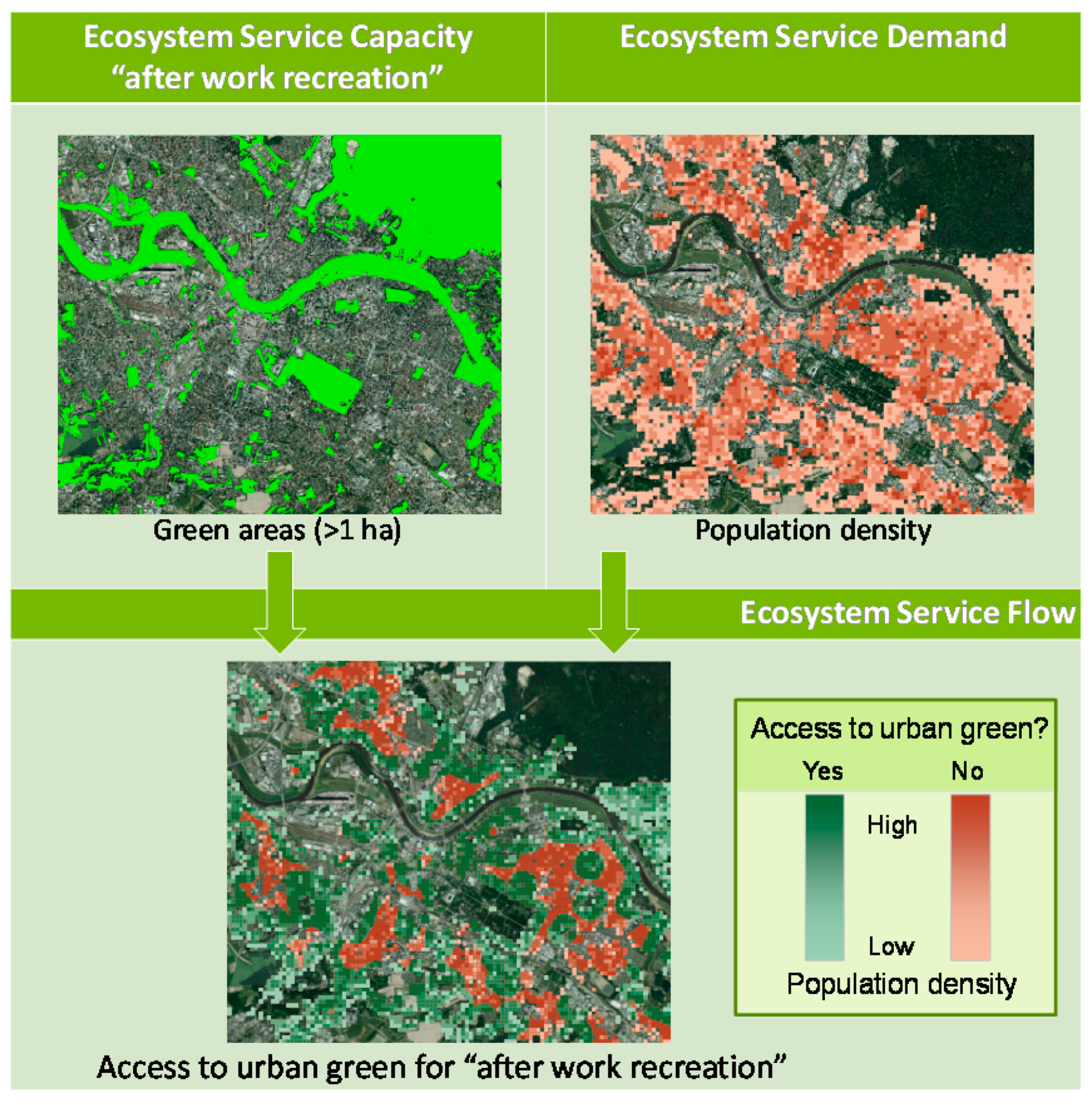
  61. Grunewald, K.; Richter, B.; Herold, H.; Meinel, G.; Syrbe, R.-U. Proposal of indicators regarding the provision and accessibility of green spaces for assessing the ecosystem service “recreation in the city” in Germany. J. Biodivers. Sci. Ecosyst. Serv. Manag. 2017, in press. [Google Scholar] [CrossRef]
  62. Martín-López, B.; Gómez-Baggethun, E.; García-Llorente, M.; Montes, C. Trade-offs across value-domains in ecosystem services assessment. Ecol. Indic. 2014, 37, 220–228. [Google Scholar] [CrossRef]
  63. Haase, D.; Larondelle, N.; Andersson, E.; Artmann, M.; Borgström, S.; Breuste, J.; Gomez-Baggethun, E.; Gren, Å.; Hamstead, Z.; Hansen, R.; et al. A quantitative review of urban ecosystem service assessments: Concepts, models, and implementation. AMBIO 2014, 43, 413–433. [Google Scholar] [CrossRef] [PubMed]
  64. Carpenter, S.R.; Bennett, E.M.; Peterson, G.D. Scenarios for ecosystem services: An overview. Ecol. Soc. 2006, 11, 29. [Google Scholar] [CrossRef]
  65. Rodríguez, J.P.; Beard, T.D.; Bennett, E.M.; Cumming, G.S.; Cork, S.J.; Agard, J.; Dobson, A.P.; Peterson, G.D. Trade-offs across space, time, and ecosystem services. Ecol. Soc. 2006, 11, 28. [Google Scholar] [CrossRef]
  66. Groffman, P.M.; Cadenasso, M.L.; Cavender-Bares, J.; Childers, D.L.; Grimm, N.B.; Morgan Grove, J.; Hobbie, S.E.; Hutyra, L.R.; Darrel Jenerette, G.; McPhearson, T.; et al. Moving Towards a New Urban Systems Science. Ecosystems 2016, 20, 38–43. [Google Scholar] [CrossRef]
Figure 1. Landscape plan of Dresden—the compact city in a green network [25] (according to landscape architect Paul); own adaption.
Sustainability 09 00198 g001
Figure 2. The restoration project site (red) along the lower course of the Prießnitz River within a densely built-up area.
Sustainability 09 00198 g002
Figure 3. Downstream view of the Prießnitz River (photo: O. Bastian).
Sustainability 09 00198 g003
Figure 4. Euplagia quadripunctaria, a protected butterfly species of European significance found at the FFH site Prießnitzgrund in Dresden (photo: O. Bastian).
Sustainability 09 00198 g004
Figure 5. The most important component of Dresden’s biotope network is the Elbe river valley (here with the famous Pillnitz Castle). The valley is also of European significance as it provides a biotope connection between the Czech Republic and the North Sea (photo: O. Bastian).
Sustainability 09 00198 g005
Figure 6. Access to urban green space as combined supply-demand indicator exemplified for a section of Dresden (Data: ATKIS Basis-DLM; DOP20 © GeoBasis-DE/BKG (2014); 2011 population raster census © Destatis (2015); Design: Richter, IOER).
Sustainability 09 00198 g006
Table 1. Guideline for landscape planning (LP) to foster compact green cities.
(I) State of Nature and Landscape(II) Planning Targets and Measures(III) Planning Impacts
(1) Guidelines for considering green structures within landscape planning for compact green cities
(1.1) Multi-object approachLP classifies different types of urban green space, e.g., urban parks, forests and private gardens (see Table 2).LP formulates planning targets and measures for different types of urban green space, e.g., targets for provision of private and public areas (see Table 2). LP evaluates the impacts of planning targets and measures on different urban green space types, e.g., impacts on urban parks (see Table 2).
(1.2) IntegrationWithin LP the status of integration of urban green space in developed areas is analyzed, e.g., the provision of roadside trees in urban centers (see Table 2).LP formulates planning targets and measures to integrate urban green spaces into developed areas, e.g., increase in per capita green spaces in the urban center (see Table 2). LP evaluates the impact of planning measures and targets to integrate urban green spaces into developed areas, e.g., risk of noisy recreational activities in parks (see Table 2).
(1.3) ConnectivityLP targets the connectivity of urban green spaces, e.g., the process of connecting green spaces between the city center and the urban fringe.LP formulates planning targets and measures to connect urban green spaces functionally and physically, e.g., connecting recreational spaces through roadside trees. LP analyzes the impact of planning measures and targets for green infrastructure connectivity, e.g., impact of green nets on biodiversity.
(1.4) Multi-functionalityThe status of green spaces providing ecosystem functions, e.g., supply of fresh air in the city center (see Table 3), is analyzed within LP. LP formulates planning targets and measures for ecosystem functions (see Table 3) provided by urban green spaces, e.g., increased cooling capacity in highly sealed districts.LP evaluates the impact of green infrastructural measures on ecosystem functions (see Table 3), e.g., effect of open private green spaces on reducing heat stress.
(2) Guidelines for considering green governance processes within landscape planning for compact green cities
(2.1) Multi-scale approachLP considers multi-scale regulations for compact green cities, e.g., the need to reduce land-take according to national targets.LP formulates planning targets and measures in alignment with multi-scale regulations for compact and green cities, e.g., implementation of green networks under national nature conservation laws.LP evaluates impacts of planning measures by reviewing multi-scale targets for compact and green cities, e.g., national targets to foster the compact city.
(2.2) Strategic approachLP analyzes the state of green infrastructure in relation to urban sprawl.LP formulates planning targets and measures for reducing urban sprawl through green infrastructure. LP evaluates measures to reduce urban sprawl through green infrastructure.
(2.3) Social inclusionLP considers different actor groups for the evaluation of nature and landscape, e.g., impact of climate change on vulnerable population groups. LP formulates planning targets and measures for various actor groups to realize compact and green cities, e.g., by motivating residents to create green buildings.LP evaluates the impact of planning targets and measures on various actors, e.g., impact of limiting urban sprawl on farmers.
(2.4) TransdisciplinarityLP uses expertise from various disciplines to analyze the status of the compact and green city, e.g., research on noise pollution.LP formulates planning targets and measures for compact and green cities using expertise from various disciplines, e.g., scientific models of climate regulation.LP evaluates the impact and conflicts of planning measures using expertise of different disciplines for compact and green cities, e.g., scientific findings on the impact of green roofing on climate regulation.
Table 2. Aspects to be considered by landscape planning (LP) for multi-object planning of green infrastructure and its integration into the built environment (based on Landscape Institute cited by [15,51]).
LP Considers Integration of Green Infrastructure into the Built EnvironmentLP Considers Urban Green Infrastructure at Site ScaleLP Considers Urban Green Infrastructure at City and District ScaleLP Considers Urban Green Infrastructure at Regional and National Scale
Roadside trees and hedgesPocket parkCity/district parksRegional parks
Green buildings (e.g., green roofs and facades)Private gardenForest parksRoad and railway networks
Green space in built-up areasCemeteriesLakesRegional greenbelts
Greenery in residential spacesPonds and streamsRivers and floodplainsNational parks
Greening of social infrastructureSmall woodlands in developed areasMajor recreational spacesOpen countryside
Greening of commercial/industrial spaces PlaygroundsBrownfieldsLong distance trails
Greenery along transport infrastructureSport grounds(Former) mineral extraction areas
Greening of water management systemsGreened city squaresAgricultural land
De-sealing/dismantling of built infrastructureAllotmentsViticulture
Vacant land
Table 3. Potential ecosystem services relevant for landscape planning (LP) considering the multi-functionality of green infrastructure and its ecosystem functions (based on a summary by [22]).
Ecosystem Functions
LP encompasses provisioning functions:
Food supply
Supply of raw materials
Water supply
Medicinal resources
LP encompasses regulating functions:
Regulation of local climate and air quality
Carbon sequestration and storage
Noise reduction
Run-off mitigation
Moderation of extreme weather events
Waste-water treatment
Erosion prevention and maintenance of soil fertility
Pollination
Biological control
The LP encompasses habitat functions:
Safeguarding habitats
Maintenance of genetic diversity
The LP encompasses cultural functions:
Recreation and mental and physical health
Nature experience
Tourism
Esthetic appreciation and inspiration
Spiritual experience, sense of place and historic information
Education and learning
Table 4. Analysis of multi-objects and integration of green infrastructure within the three sections of the landscape plan: Section (I) State of nature and landscape; Section (II) Planning targets and measures; and Section (III) Planning impacts (note: dark cells: considered; light cells: not considered).
Section (I)Section (II)Section (III)
Integration of green infrastructure
Roadside trees and hedges
Green buildings (e.g., green roofs)
Green space in built-up areas
Green space in residential areas
Greening of social infrastructure
Greening of commercial/industrial spaces
Greenery along transport infrastructure
Greening of water management systems
De-sealing/dismantling
Greening of vacant land
Urban green at site scale
Pocket park
Private garden
Cemeteries
Ponds and streams
Small woodlands in developed areas
Playgrounds
Sport grounds
Greened city squares
Allotments
Vacant land
Urban green at city and district scale
City/district parks
Forest parks
Lakes
Rivers and floodplains
Major recreational sites
Brownfields
(Former) mineral extraction areas
Agricultural land
Viticulture
Urban green at regional and national scale
Regional parks
Road and railway networks
Regional greenbelts
National parks
Open countryside
Long-distance trails
Table 5. Consideration of ecosystem functions in different sections of the landscape plan: Section (I) State of nature and landscape; Section (II) Planning targets and measures; and Section (III) Planning impacts (dark cells: considered; light cells: not considered).
Section (I)Section (II) Section (III)
Provisioning functions
Food supply
Supply of raw materials
Water supply
Medicinal resources
Regulatory functions
Local climate and air quality regulation
Carbon sequestration and storage
Noise reduction
Run-off mitigation
Moderation of extreme weather events
Waste-water treatment
Erosion prevention, maintenance of soil fertility
Pollination
Biological control
Habitat functions
Safeguarding habitats
Maintenance of genetic diversity
Cultural functions
Recreation for mental and physical health
Experience of nature
Tourism
Esthetic appreciation and inspiration
Sense of place, historic information
Education and learning

