Article

The Influence of Natura 2000 Sites on Land-Taking Processes at the Regional Level: An Empirical Analysis Concerning Sardinia (Italy)

Dipartimento di Ingegneria Civile, Ambientale e Architettura, University of Cagliari, 09123 Cagliari, Italy
*
Author to whom correspondence should be addressed.
Sustainability 2017, 9(2), 259; https://doi.org/10.3390/su9020259
Submission received: 10 November 2016 / Revised: 26 January 2017 / Accepted: 1 February 2017 / Published: 13 February 2017

Abstract

:
This article focuses on the role that the provisions of the Natura 2000 Network play in affecting land-taking processes by looking at the Italian region of Sardinia, where strict rules on land development have been enforced since 1993 through regional landscape plans and where an extensive Natura 2000 Network, covering nearly 19% of the regional land mass, was established in compliance with Directive 92/43/EEC on the conservation of natural habitats and of wild fauna and flora and Directive 2009/147/EC on the conservation of wild birds. The results and inferences of our study could be easily generalized to other European Union regions, provided that similar geographic datasets are available. By shedding some light on the relation between land take on the one hand, and nature conservation and landscape protection on the other, it is possible to enhance regional planning policies to prevent or hinder land-taking processes, and, by doing so, to help implementing the European Commission recommendation on no net land take by 2050 into the EU regional policies.

1. Introduction

Natura 2000 is a coherent network of areas established under Directive 92/43/EEC (“Habitats” Directive), which includes sites of community importance (SCIs) and special areas of conservation (SACs) identified under the provisions of the Habitats Directive itself, as well as special protection areas (SPAs), identified under the provisions of the “Birds” Directive (Directive 2009/147/EC).
An SCI is a site that significantly contributes to the maintenance or restoration of a natural habitat at a favorable conservation status [1], whereas a SPA is established to protect bird species threatened with extinction, vulnerable to changes in their habitat, or considered rare because of their small populations or restricted local distribution. Member States must designate the most suitable areas as SPAs on the basis of scientific data [2].
For both SACs and SPAs, mandatory conservation measures must be established; moreover, legal definitions of key concepts such as “natural habitats”, “conservation”, and “conservation status of a natural habitat” are provided in Article 1 of the Habitats Directive [3]. As a consequence, protection of Natura 2000 sites is expected to significantly boost maintenance and restoration of natural habitats and of the populations of flora and fauna. Moreover, the area where an SCI or an SPA has been established is bound to maintain its present status of mostly non-artificial land cover, since any plan or project that is not necessary to the management of the site but could possibly impact adversely on it must undergo a specific environmental assessment (termed “appropriate assessment” [4]) aimed at preventing human activities from adversely affecting the integrity of Natura 2000 sites (N2Ss).
In its “Roadmap to a Resource Efficient Europe”, the European Commission established an ambitious goal for the European Union, that of achieving no land take by 2050; a key milestone for the year 2020 was set accordingly, by establishing that in the programming period 2014–2020 European policies should take account of their impacts on land use. “Land take” (or “land uptake”) is a Euro-English expression variously defined and associated to urban and other artificial land developments and to the loss of agriculture, forest, and other natural or semi-natural land. It is a significant issue in the European Union, as it amounted to approximately 1000 km2 per year between 1990 and 2000, falling to around 920 km2 between 2000 and 2006 [5] (p. 15), with an average yearly growth pace in the countries of the European Union for the 1990–2006 time interval estimated at 0.5 percent by the European Environment Agency [6] (p. 17). At the National (Italian) level, a recent report [7] shows that the amount of artificial land (that is, land “taken” by urban and other developments) has increased steadily, reaching 21,000 km2 (7.0%) in 2014, and that remarkable differences can be found across the Italian NUTS2 (acronym for “Nomenclature of Territorial Units for Statistics”, from the French Nomenclature des Unités Territoriales Statistiques, second level) Regions.
Several studies analyze the complex and multifaceted relationships between land-taking processes and N2Ss. It is widely recognized that land-taking processes are limited and mitigated by protection measures concerning habitats and species [8], and that ecological integrity, preserved by the establishment of N2Ss, prevents widespread land-use change [9]. However, sound quantitative relationships between the presence and location of N2Ss and land take mitigation have not been identified yet [10], even though in the literature it is generally taken for granted that the level of natural protection measures and the intensity of artificialization are negatively correlated (among many [11,12,13]).
Mücher et al. [14] analyzed land-use change patterns related to the presence of N2Ss by processing aerial photographs dating back to 1950, 1990, and 2000. Their results show inconsistency, since the relationship between land-use changes and distance from N2Ss depends on the CORINE [15] land cover levels: at level 1, a decreasing trend of land-use change (from agricultural to urban) with respect to distance from N2Ss is detected, whereas no such relationship is found in case of level 2 or level 3. With respect to the Dutch Natura 2000 Network, Hazeu et al. [16] analyzed aerial photographs and argued that the presence and size of N2Ss seem to mitigate land-use changes, especially close to already-urbanized land.
A significant approach to detect possible correlations between land use changes and the presence of SCIs, SACs, and SPAs was proposed by Martínez-Fernández et al. [10], who assessed land use changes in Spain. Martínez-Fernández et al. identify a comparatively higher persistence of natural areas in protected areas than in N2Ss, whereas the latter show a more significant persistence in terms of agricultural land covers. Martínez-Fernández et al.’s approach was based on transition matrices that detect land cover changes by comparing the 1987 and 2006 CORINE land cover maps. They build upon previous studies by Pontius et al. [17] and by Alo and Pontius [18], who analyzed the dynamics of: (i) forests, open areas, residential areas, and others in Massachusetts; and, (ii) forests in Southwestern Ghana. The assessments are based on land-cover transitions analyzed through: (i) MassGIS maps dating back to 1971 and 1999 [19]; and, (ii) Geographic information systems (GIS) and remote-sensing techniques, making use of satellite images dating back to 1990 and 2000.
All of the above-mentioned studies analyzed relationships between land-taking processes and N2Ss either by using direct comparisons of descriptive statistics [10,17,18] or by assessing land-use changes on a 1-to-1 correlation to the presence and size of Natura 2000 sites [14,16]. Our research perspective, in this paper, builds upon the hypothesis that land take depends on a set of factors, one of which is the presence and size of N2Ss, and that the relationship between land take and N2Ss can be better understood and explained in the context of a quantitative analysis which includes a set of variables that represent the factors. In other words, we try to better explain the relationship that Mücher et al. and Hazeu et al. have detected, and to do so in quantitative terms by going beyond descriptive, non-inferential, analyses such as the Martínez-Fernández’s et al.’s ones.
Some previous studies have analyzed what the main drivers of land take at the regional level are by means of GIS-based analyses coupled with regression models by including a reasonably wide range of factors comprising physical, planning-related, and social drivers [20,21]. By building upon such studies, our goal in this paper is to focus on the role that the provisions of the Natura 2000 Network, which consists of SCIs and SPAs [22], play in affecting land-taking processes by looking at the NUTS2 Italian region of Sardinia.
In Section 2 we provide background information on our case study. In Section 3 the definition of land take and of the variable we use to measure the size of land-taking processes are presented and the variables representing factors which influence land take and the role of N2Ss in mitigating land-taking processes are discussed. Section 4 presents the results of the econometric model we use to relate land take to its potential drivers identified in the previous Section, with particular reference to the presence and size of the Sardinian N2Ss. Finally, in Section 5 we propose a discussion on the relation between land take on the one hand and nature conservation and landscape protection on the other hand, which shows that it could be very possible to enhance regional planning policies to prevent or hinder land take, and, by doing so, to help implementing the European Commission’s recommendation on no net land take by 2050 into the European Union’s regional policies.

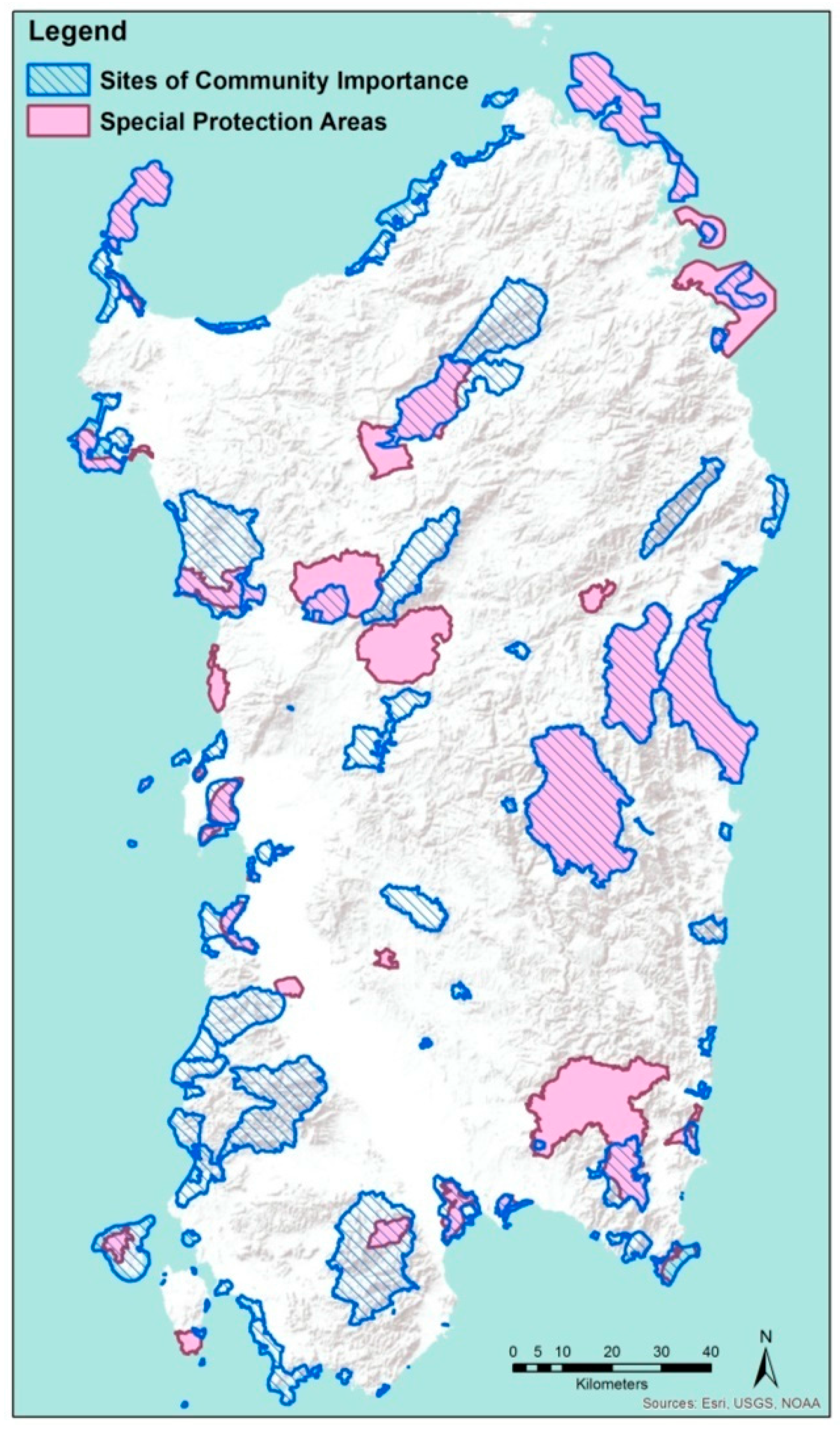
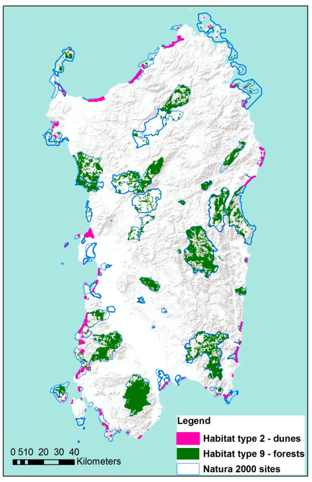
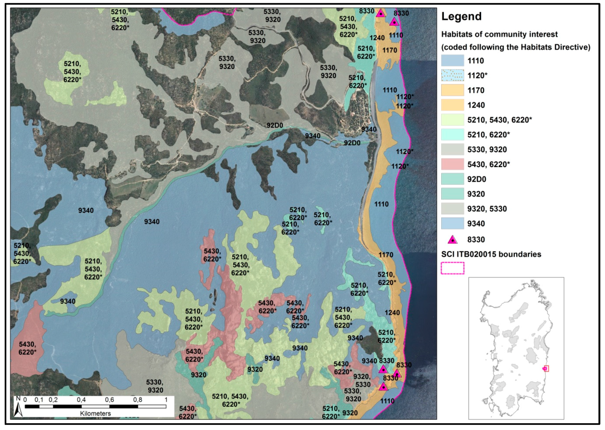
2. Study Area: The Sardinian Natura 2000 Network

Our empirical study concerns Sardinia, one of the two insular regions of Italy, located to the southwest of the Italian Peninsula.
The reason for this selection is that strict rules on land development have been enforced since 1993 through regional landscape plans, which have also singled out areas (especially coastal ones) in which new developments are almost completely forbidden; furthermore, an extensive Natura 2000 Network, covering nearly 19% of the regional land mass, was set up in compliance with the Habitats and Birds Directives. Moreover, a dynamic study of land take in Sardinia is possible since data on land-taking processes are available with reference to two years characterized by an adequate temporal distance; in addition, because Sardinia is an island, the boundaries of the region where the Natura 2000 Network is defined are straightforwardly identified by the coastline, hence, the correlation between the presence and size of the regional N2Ss and land take, if any, is clear-cut.
Soon after the approval of the Habitats Directive, a national project titled “Biotopes Inventory of Italy” (BioItaly), aimed at drafting a preliminary list of proposed SCIs, was launched in Italy. By June 1995, the first stage of the project closed and a first list of proposed SCIs was circulated [23]. In 2000, the National Minister for the Environment issued a Decree that contained a list of SPAs (9 of which are in Sardinia) and a list of proposed SCIs (114 in Sardinia), which meant that the provisions of Article 6 of the Habitats Directive entered in force in the listed sites. Political and civic debates followed as regards the selection of the sites; hence, the preliminary list of proposed SCIs was deeply revised in Sardinia, to the extent that, out of 114, 92 SCIs were actually designated in 2006, when the first list of SCIs for the Mediterranean biogeographical region was approved by the European Commission [24]. A small number of further SCIs were designated in Sardinia between 2012 and 2013, so they do not fall within the scope of this study. As far as the SPAs are concerned, after the first group of nine sites was designated in 2000, a second group comprising six further sites followed in 2004 [25] and a third comprising 22 sites in 2007 [26]. These additional designations were required to fulfill national obligations under the Birds Directive, after the Judgment of the European Court of Justice Court of 20 March 2003 (case C378/1) ruled that Italy had failed to classify an appropriate size of the national territory as SPAs. Since then, no further SPAs have been designated in Sardinia; hence, the regional 37 Natura 2000 network contains 37 SPAs.
To sum up, in the time frame we investigate in this study, the regional Natura 2000 network gradually evolved from 123 sites in 2000 (114 proposed SCIs and 9 SPAs) to 126 sites (92 SCIs and 37 SPAs) in 2007. It has to be underlined, however, that some SCIs coincided with, or overlapped, some SPAs. At present no SACs have yet been established in Sardinia. The spatial distribution of N2Ss as of 2007 is shown in Figure 1.
N2Ss’ characteristics, irrespective of their type, are described in a standardized way across the European Union through the so-called “Natura 2000 standard data forms” [27]. A standard data form lists habitats and species of community interest that can be found in a given site, and provides quantitative data (for instance, area covered for habitats and population size for species) and qualitative information concerning conservation status for both habitats and species. Furthermore, other important pieces of information concerning a given site’s quality and importance and a coded list of human activities that generate (or may generate) impacts on the site are also provided in the standard data forms.
Hence, quantitative and qualitative information on habitats and species at various levels (site level, regional, national, biogeographic) can be gathered from the standard data forms, which represent a powerful descriptive and dynamic tool, since they are regularly updated. However, the standard data forms need to be complemented by other tools, as they do not provide information on the spatial distribution of habitats of community interest and of habitats of species of community interest. In the European Union, some large scale projects that attempt to map the potential distribution of habitats and ecosystems have been carried out [28]. At the regional (Sardinian) level, two main spatial datasets have been implemented, namely the so-called “carta della natura” (Nature map), and the so-called “carta degli habitat” (Habitat map); they describe the actual distribution of habitats by using two different classification schemes. The former, having a scale of 1:50,000, maps habitats in the whole island according to the CORINE [15] biotopes nomenclature [29], while the latter, which has a scale of 1:10,000, only maps habitats of community interest within the boundaries of N2S according to the Habitats Directive nomenclature [30]. The latter is, therefore, more useful for the purposes of the Habitats Directive, and especially for defining conservation measures and for granting development and planning permissions under the already mentioned “appropriate assessment” procedure.
To provide the reader with an example of the information provided by the map (whose attributes, in a GIS environment, can be joined with those contained in the standard data forms), Figure 2 shows the spatial layout of two habitat types, forests and sand dunes, within Sardinian N2S, while Figure 3 provides a detailed representation of the spatial layout of habitats within a single N2S.

3. Materials and Methods

We use an ordinary-least-squares (OLS) econometric approach to analyze, detect, and discuss relationships between land take and its possible determinants, in order to enhance the explanatory potential of previous studies based on descriptive statistics for the following reasons. First, in the relevant literature (see, among many, the essays cited in the Introduction) land take and related factors are mostly represented trough quantitative variables. Since econometric models are generally set up and implemented in order to detect interactions and possible causality nexus in quantitative multiple-variable contexts, to use this type of models to study land-taking processes is pretty straightforward.
Moreover, substantial enhancements related to the use of econometric models with respect to descriptive approaches are identified, on the one hand, by the capability of these models to deal with, and analyze, the simultaneous effects of multiple explanatory variables on the dependent, land take-related, variables and, on the other hand, by their capability to put in evidence the impact of changes in each factor, not only in qualitative terms, but also from a quantitative point of view. In other words, econometric models not only allow their users to understand if a factor influences land take in a multiple-variable context, but also by how much, which is very important as regards policy recommendations implied by the outcomes of the model implementation.
Third, the outcomes and implied policy recommendations are important in qualitative terms as well, since the whole implementation process of the econometric model we use to analyze and explain land-taking processes is intrinsically qualitative. The use of factors we include as determinants of land take is based on qualitative considerations (as per the model definition in Section 3.2), and the policy recommendations implied by the model outcomes, presented in Section 5, are intrinsically aimed at improving the quality of life of the local communities by means of mitigating land-taking processes.

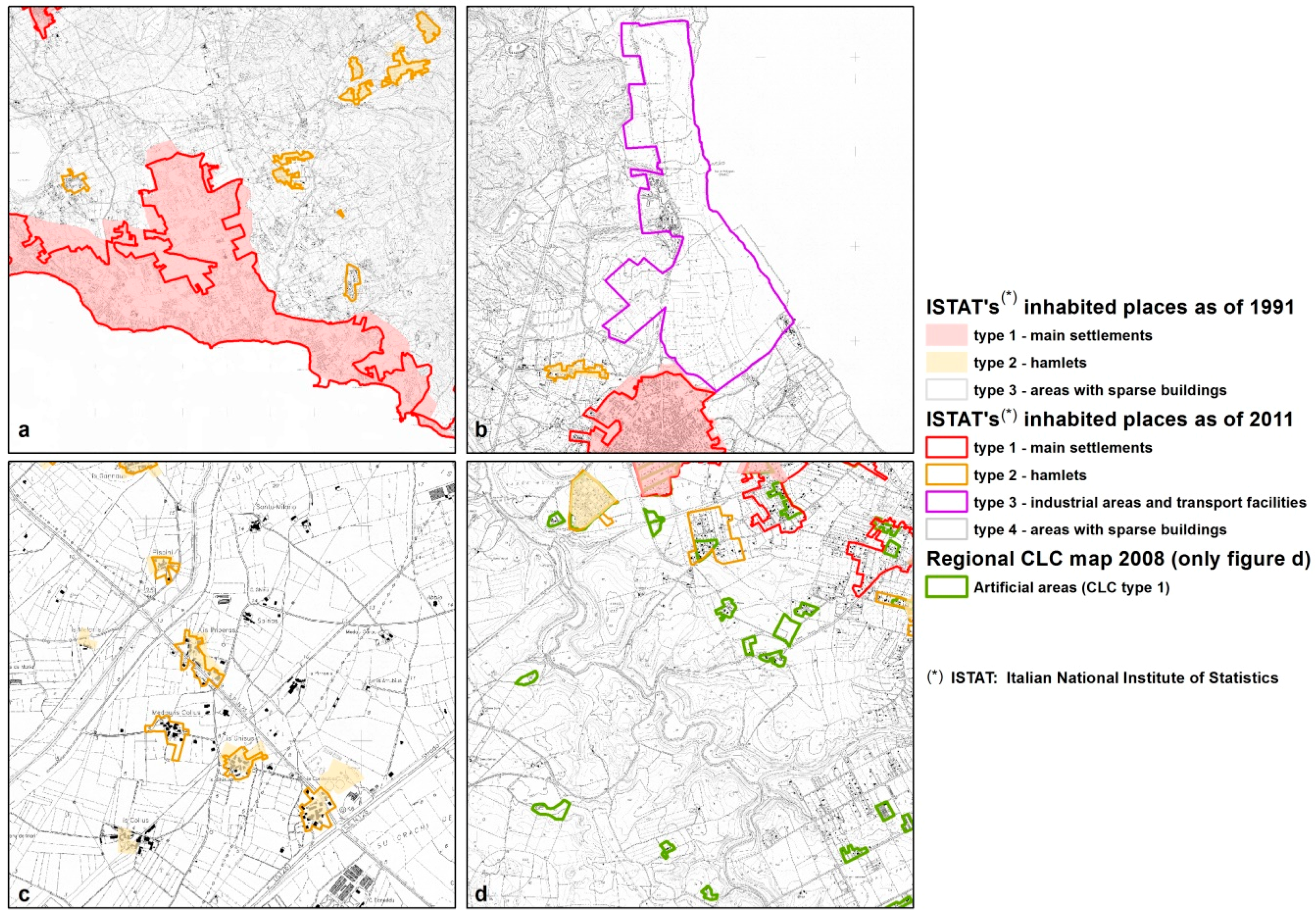
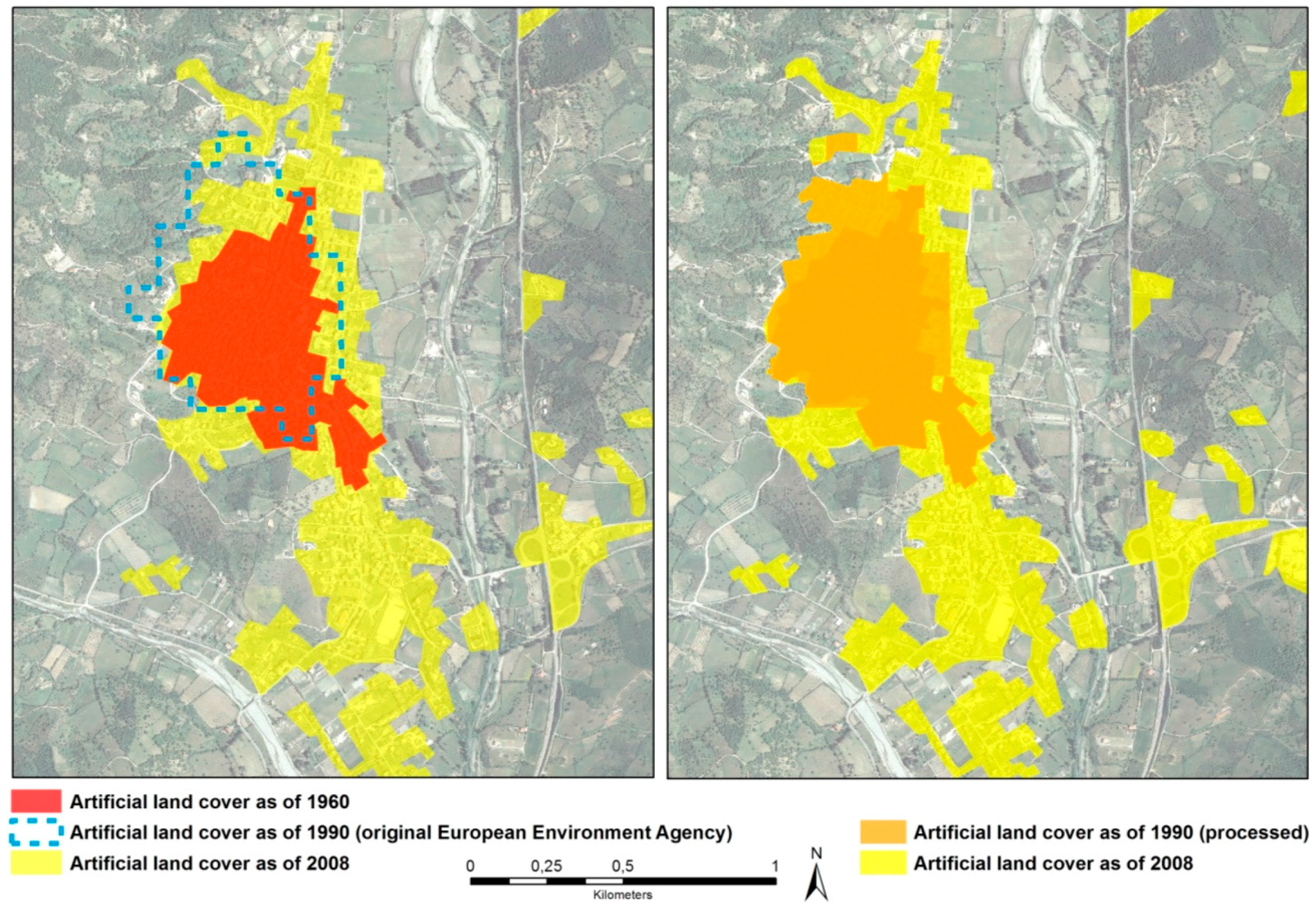
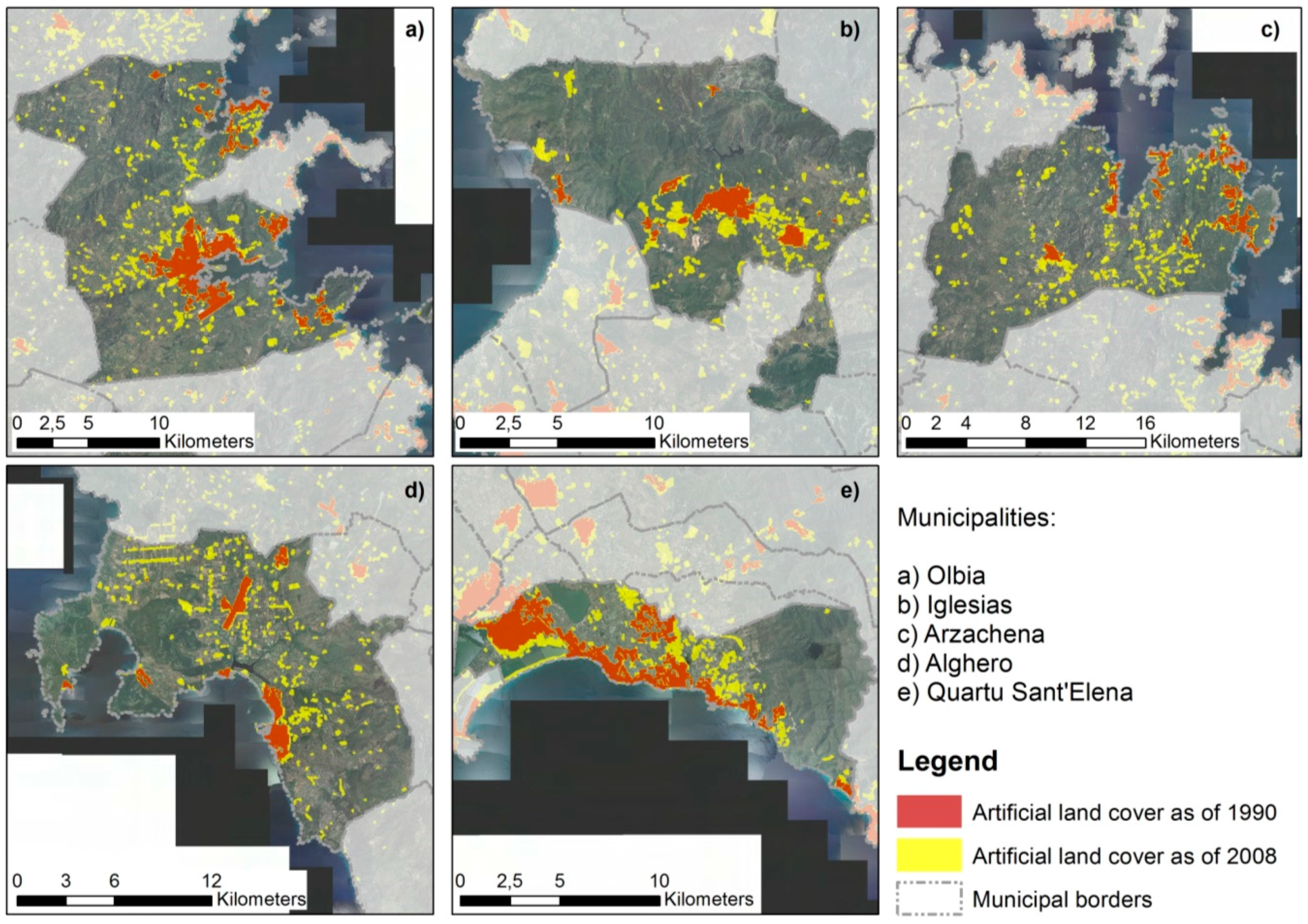
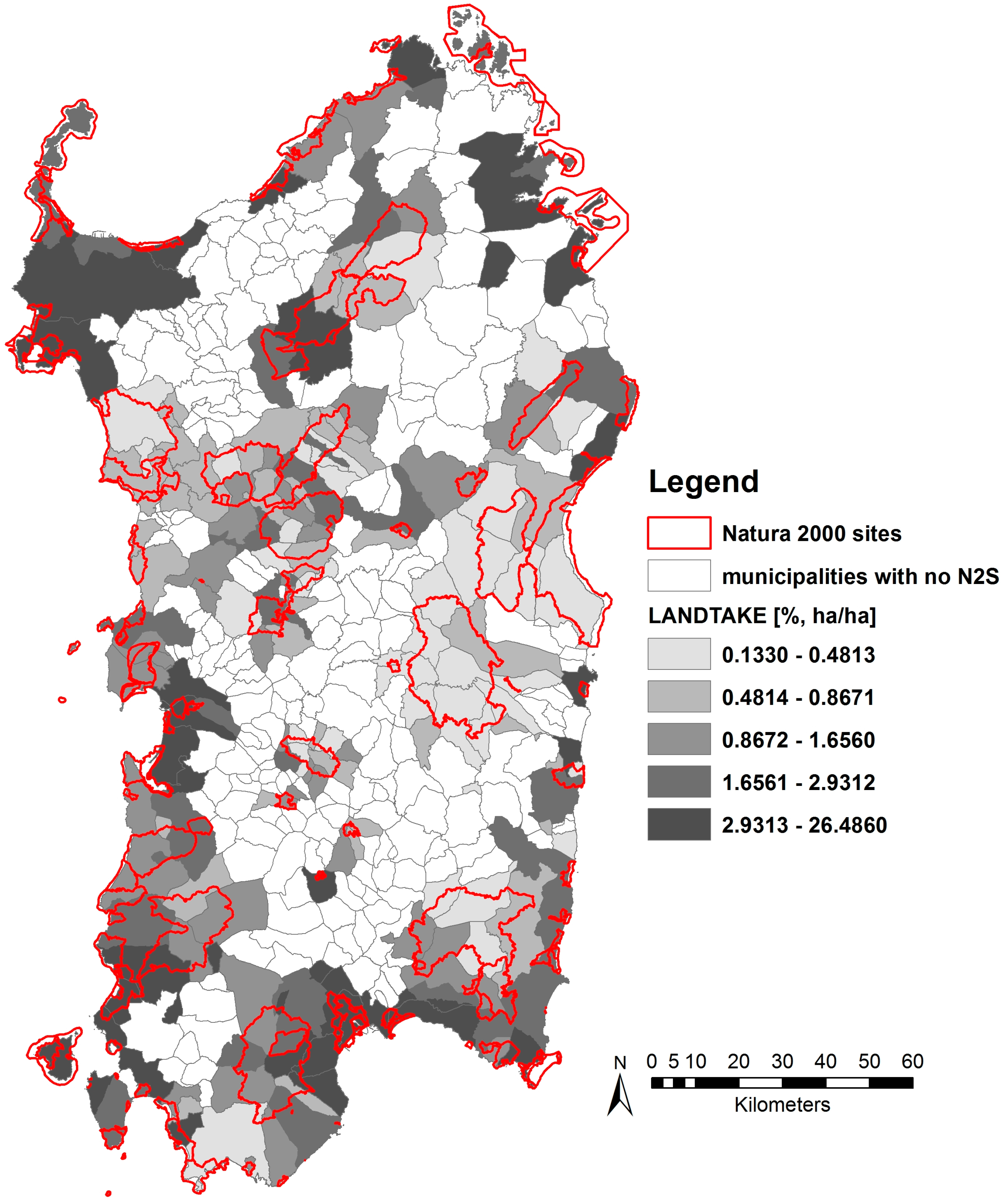
3.1. Defining and Measuring Land Take

Among the various definition of “land take” that have been put forward, for its operational character we choose the one proposed by the European Environment Agency (EEA), according to which land take is the “change of the amount of agriculture, forest and other semi-natural and natural land taken by urban and other artificial land development” [31]. Accordingly, land take can be regarded as a subset of the complete set of land cover change types and processes, which, in the European Union, are often identified using the CORINE Land Cover (CLC) dataset [32] provided by the EEA for different time series [33].
The widespread use of the CLC to analyze land cover changes in general, and land take in particular, is due to a number of reasons, among which the wide coverage of the dataset [34], the unified methodology of data collection over time [35] and the standardized, hierarchical classification scheme. However, several studies have put in evidence CLC limitations and shortcomings. Some research has highlighted the presence of classification errors, especially due to semantic ambiguities at the third (and most detailed) level of the hierarchy [35]; moreover, a number of studies have argued that the mapping scale and minimum cartographic unit are quite large for analyses at the local scale, which may lead to underestimating artificial land cover when small-size developments and urban fragments are involved (among many, [35,36,37]); nevertheless, the scale is deemed suitable for analysis of land-cover change processes not only at the European, but also at the national and regional level [37].
At the first level, the broadest and most general, the CLC classification has the following non-artificial-surface categories: (i) agricultural areas; (ii) forests and semi-natural areas; (iii) wetlands; and (iv) waterbodies. We, therefore, define land take between 1990 and 2008 as the change of a land parcel from a non-artificial condition in 1990 to an artificial condition in 2008. We take into consideration the period 1990–2008 because this time interval is characterized by a starting point in which N2Ss were not established and protected yet, since the provisions of the Habitats and Birds Directives were far from being implemented (actually, the Habitats Directive had not even been approved yet), and a final point where the most part of the Habitats and Birds Directives was implemented in terms of established N2Ss in Sardinia.
Due to the already mentioned limitations related to the scale, rather than using the CLC European maps available from the EEA, we chose to refer to more detailed data.
As regards today, in Italy land take cannot be derived from a detailed descriptive cartography, in order to detect its dynamics for large time periods. A national map of land take was recently produced by ISPRA, the Italian Superior Institute for Environmental Protection and Research [38]; however, it cannot be used to assess land take dynamics because only one time series (i.e., the 2016 edition, using data from 2012 and 2015) is available.
We, therefore, chose to use the following two map sources:
  • the European Environment Agency’s Urban Morphologic Zones maps as of 1990 [39]; urban morphologic zones are “sets of urban areas laying less than 200 m apart”, and are defined as regards to appropriately selected subclasses of the CLC class named “artificial surfaces”, that feature urban tissues and their spatial frameworks;
  • the regional CLC map implemented by the Sardinian administration, available from the geoportal of the Sardinian administration [40]; from this dataset we select polygons representing “artificial surfaces”, the first level class of the CLC.
The use and interpretation of CLC maps adopted in this study is consistent with [41,42,43,44].
Since these datasets differ in terms of spatial resolution, we eliminate inconsistencies by preprocessing the 1990 map using a third map displaying historic settlements as of 1960 as a reference point (see Figure 4).
Notwithstanding the mismatch in resolution between the two data sources and the consequent need for preprocessing, we feel that this was the best possible choice to assess land take at the regional scale in the 1990–2008 time period in Sardinia.
Other spatial datasets provided by authoritative sources and describing built-up areas do exist, but they are not fit for the purpose. Among such spatial data sets, the most prominent is possibly the one produced and made available by the Italian National Institute of Statistics (ISTAT), that provides the spatial layout of the so-called “inhabited places” for the years 1991, 2001 and 2011 [45]. Since it is a census-driven classification, inhabited places (“località”, in the original Italian) result from an aggregation of single census tracts and are defined as areas consisting by at least fifteen buildings; their boundaries include such buildings and their premises (courtyards, vegetable gardens, etc.); buildings that are farther apart than 70 m (within the main settlements) or 40 m (outside the main settlements) are not included therein [46] (p. 28).
Inhabited places are classed into four groups: (i) main settlements; (ii) hamlets; (iii) industrial areas and transport facilities; and (iv) areas with sparse buildings. Any piece of land must belong to one of the four groups; as a consequence, forests and agricultural areas are classed in the fourth group, as well as any other land with detached houses farther than 40 m from one another, or with fewer than fifteen grouped buildings. We tested the 1991 and 2011 datasets in order to understand whether such data could be used to measure land take between 1991 and 2011 (an alternative time range to the one we used) and found out that the answer to this question is negative for a number of reasons: first, boundaries in the 1991 map are much coarser than in the 2011 map, hence, vast areas are classed as either main settlements or hamlets in 1991 but belong to the fourth group (“areas with sparse buildings”) in 2011 (this would paradoxically lead to negative local land take); second, the third group, meaning industrial areas and transport facilities, only started being mapped in 2001 [46], (p. 28) (this would overestimate local land take); third, a number of hamlets mapped in 1991 are not mapped in 2011 (this would again lead to negative local land take); fourth, because of the aim of these datasets, and of the very definition of inhabited places, artificial areas, such as detached buildings in the countryside or infrastructure networks, are not mapped (this would lead to greatly underestimated artificial land in both years). Figure 5 provides some cartographical examples of these issues.

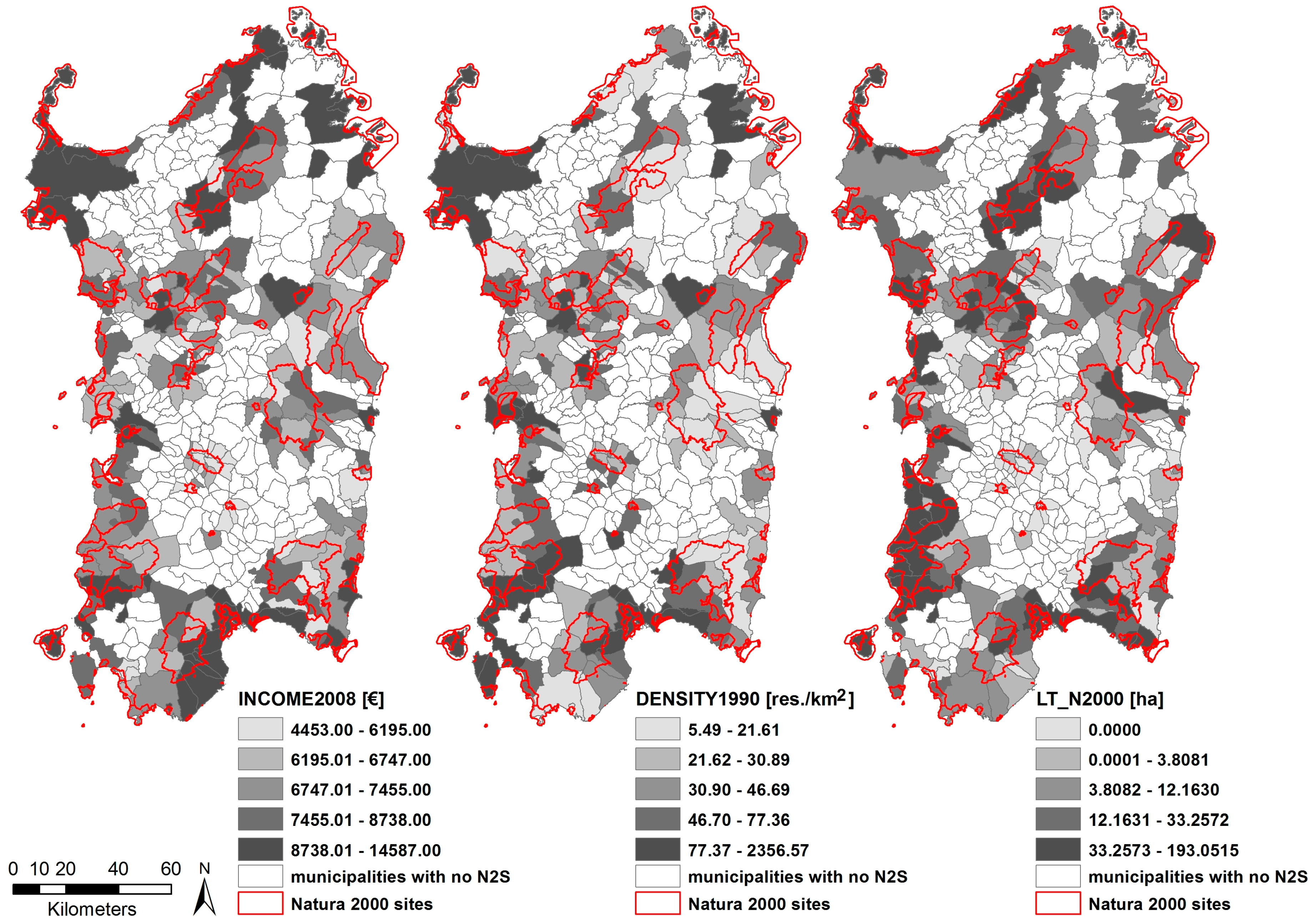
3.2. Natura 2000 Sites and Other Factors Influencing Land Take

We estimate an OLS model to identify if and to what extent the model covariates influence Sardinian land-taking process in the 1990–2008 period. In this Section we, therefore, identify what variables could tentatively be assumed to influence land take and what our preliminary expectations are.
N2Ss are established to maintain and restore natural habitats in a favorable conservation status. As we put in evidence in Section 1, natural habitats are areas which entail natural or semi-natural conditions due to their biotic and abiotic characteristics. A favorable conservation status of natural habitats implies the long-run maintenance and possibly improvement of its natural distribution, structure and functions, and the survival of its characterizing species as well. Hence, since maintenance and restoration of natural characteristics of habitats, and species therein, are the founding reasons of Natura 2000 Network, land take should be minimized in the N2Ss; as a consequence, the presence and size of these sites should be negatively correlated to land-taking processes.
Moreover, habitats areas belonging to N2Ss are intrinsically non-artificial areas and whichever project or plan is likely to generate significant negative impacts on the non-artificial and non-urbanized status of a N2S has to be appraised through an appropriate assessment procedure, which aims at defining and offering to public and private stakeholders, planners and practitioners a basket of planning policies that may be effective: (i) to help mitigating the effects of planned developments related to land-use change; (ii) to help building future spatial layouts as concrete alternatives to scenarios entailed by the implementation of the ongoing planning policies, which may very possibly cause serious damages to habitats and species [47]. In other words, the appropriate assessment procedure is very close to a strategic environmental procedure in case of a plan or program, or to an environmental assessment procedure, in case of a project [48]. These procedures imply the identification of measures which address the issue of impacts on natural resources.
Hence, since appropriate assessments are mandatory in case a plan or a project might affect a N2S, and since land-taking processes within N2Ss are minimal, if any, there are two possible relationships between the presence and size of N2Ss within municipalities. The first and, perhaps, the most intuitive, is that land take is negatively correlated to the N2S area, since the greater the N2Ss, the less the land uptaken. However, there is another way of looking at this correlation, which is related to the following argument, proposed and discussed by Dewi et al. [49] and Zoppi and Lai [20], among many, and termed “leakage” in Meyfroidt et al. [50]. If a strict environmental protection regime is established on a land parcel, and land take is forbidden, e.g., due to conservation of natural resources, a proximity effect may be detected so that land-taking processes may eventually develop in areas close to the protected parcel. Dewi et al. and Meyfroidt et al. put in evidence a proximity effect related to areas where tropical forests exploitation is prevented, whose neighboring plots are often characterized by heavy forest exploitation. Zoppi and Lai discuss a proximity effect related to the coastal strip of Sardinia, where new developments are by and large prevented under the provisions of the regional landscape plan. In the Sardinian case, the most important land-taking processes occurred in urban areas almost immediately adjacent to the coastal strip.
In order to control for the presence of a proximity effect, we weight the municipality area included in N2Ss by the total land area of the municipality. By doing so, we consider land take as dependent on the share of the municipality area included in N2Ss, whose lowest values should imply that comparatively more room is available in the municipality for land-taking processes to occur, possibly in the parcels immediately adjacent to protected areas, while less room should be available were the N2Ss share larger.
Another variable related to land take which is connected to the presence of N2Ss is the quantity of land uptaken within the N2Ss belonging to a municipal land area, which puts into evidence if, and to what extent, appropriate assessments have been effective in preventing negative impacts of the implementation of planning policies on N2Ss. This implies that we expect that the higher the land take size, the higher the land uptaken from N2Ss within a municipality.
A control variable related to the planning rules in force that needs to be included in the set of factors we use to detect the impact of the presence and size of N2Ss on land-taking processes is the municipal land area included in the coastal strip which is part of a N2S as well, since, as we stressed above, under the provisions of the regional landscape plan, changes in land cover in the coastal strip are almost totally prevented, which means that if an area is included in the coastal strip, then land take is forbidden regardless of whether the area is part of a N2S.
Another control variable that we consider as a determinant of land take is the municipal land area that in the Nineties and in the first five years of the new century was classified, under the provisions of the regional planning code, as areas where land take and whichever new development were prevented and which overlaps N2Ss parcels, which, once again, indicates that land take is in any case forbidden, since these areas are still protected under the provisions of the regional landscape plan.
Moreover, we use control variables that concern:
  • two classes of the CLC classification, namely “Wetlands” and “Waterbodies” (first level, non-artificial-surface categories); this variable is almost invariant between 1990 and 2008, since very few parcels of land included in these non-artificial land cover types and in N2Ss have changed their status of non-artificial surface in the period 1990–2008;
  • the average slope of the municipal land area included in N2Ss, which contributes to the stability of a N2S in terms of land take.
The impacts of the presence of areas belonging to the two classes and to N2Ss on land take and of the slope of the N2Ss are expected to be negative, everything else being equal, as it is fairly intuitive that the larger the invariant municipal land area that belongs to N2Ss, the lower the municipal land area that can eventually change its status from non-artificial to artificial. It has to be put into evidence that the classes of the first level (non-artificial-surface categories) of the CLC classification other than wetlands and waterbodies, that is, agricultural areas and forests and semi-natural areas, can possibly change their status from non-artificial to artificial, and, as consequence, they do not entail an invariant character.
We use the following two variables related to social and economic aspects of municipalities as well:
  • residential density, in order to detect if it is positively correlated to land take, which would imply an agglomeration impact, as many essays put into evidence [20,51,52,53,54];
  • per capita income, which may either be negatively correlated to land take, in case, for example, a comparatively high municipal per capita income pushes up investments in agriculture, or, to the contrary, investments are diverted to, say, new building developments [55].
Finally, a spatially-lagged variable which takes into account autocorrelation of the variable which indicates land take in the period 1990–2008 is used in the set of dependent variables, and it is defined according to Anselin’s [56,57] methodology.
Table 1 reports the definitions and descriptive statistics concerning land take and factors tentatively considered as likely determinants and, moreover, it lists the data sources we used for each variable. The values that the dependent variable (LANDTAKE) and the variables that we tentatively assume as drivers were all calculated in a GIS environment, but for data on income, that were available off the shelf from the website of the Italian Ministry of Economy and Finance.
Artificial areas as of 2008 were mapped by simply selecting the appropriate polygons (meaning: those polygons whose land-cover first digit attribute equals “1”) from the Sardinian CLC-based land-cover maps for 2008, while the layout of artificial areas as of 1990 was obtained by preprocessing the urban morphologic zones for 1990 as previously mentioned. A third shapefile that describes those parcels of land which became artificial between 1990 and 2008 was next derived, which made it possible to calculate, for each Sardinian municipality, the share of municipal land that was taken in the 1990–2008 period (variable LANDTAKE).
In addition to the above data on land cover, we used other spatial data available from the regional spatial data infrastructure (such as digital terrain models, administrative borders, landscape units of the regional landscape plan currently in force, and zoning scheme of the former landscape plans) and non-spatial data concerning population and income. A geographic dataset was, therefore, developed and the value of each variable for each municipality was calculated in a GIS environment through geoprocessing analyses and more advanced techniques (such as, for instance, the Moran’s I test performed in GeoDa, a software program developed by the Center for Spatial Data Science of the University of Chicago, IL, USA [62]), allowing us to analyze the spatial distribution of the variables.
From now on, we consider only the subset of municipalities for which the value of the variable NAT_2000 is greater than zero, that is, the 167 Sardinian municipalities (out of 377) whose territory overlap at least one SCI or SPA.

4. Results

Sardinian figures related to 1990 and 2008 put into evidence that an increase in artificial land did occur from 1990 to 2008 of about 1.66 percent, starting with 38,132 hectares in 1990, and ending up with 78,379 hectares in 2008, which corresponds to a land take amount of about 3.25 percent [63]. In Figure 6, some maps accounting for land take at the municipal level between 1990 and 2008 for five Sardinian municipalities are presented.

4.1. Analysing Correlations

The coefficients ρ, which measures the linear correlations between the dependent variable and its potential drivers, are reported in Table 2, which puts into evidence that (leaving the autocorrelation variable aside) the most significant positive correlations are those between the dependent variable LANDTAKE, on the one hand, and the variables INCOME2008 (ρ = 0.483), DENSITY1990 (ρ = 0.439), and LT_N2000 (ρ = 0.415), on the other hand, all being positive and having similar values. This signals a positive correspondence between the magnitude of land take at the municipal level between 1990 and 2008 and, respectively, per capita income in 2008, residential density at the beginning of the time interval under consideration, and the amount of municipal land taken within N2Ss. This indicates that the magnitude of land take is larger in municipalities characterized by higher per capita incomes and by higher population densities, and that the greater land take is within the Natura 2000 network, the greater it is within the whole municipality.
The other positive correlations are not as strong as the previous one, as the coefficients amount to 0.054 (COASTRIP) and 0.172 (WATER), meaning that land take at the municipal level does not appear to correlate with the amount of municipal land which is included both in the Natura 2000 network and in the coastal strip or with the amount of wetland and freshwater that is also part of N2Ss. The three remaining correlations (with SLOPE, NAT_2000, OLDPLAN) show a negative sign and are not as relevant as the highest positive ones.
Figure 7, where polygons represent cities and towns, shows the geography of the dependent variable LANDTAKE while Figure 8 shows three maps that describe the spatial configuration of the potential determinants having the highest correlations, i.e., INCOME2008, DENSITY1990, and LT_N2000.

4.2. The Outcomes of the Regression Model

An OLS model was run to identify if and how the covariates identified in Section 3.2 influence Sardinian land-taking process in the 1990–2008 period.
At the outset, we implement two OLS models, whose covariates are the levels and the logarithms of the variables of Table 1. The level-based model shows a higher goodness of fit than the logarithmic model (see Appendix A). The estimates of the coefficients of the covariates of the two models are consistent with each other. The adjusted R-squared coefficient of the first model is higher than 54 percent, while it is slightly lower than 50 percent in the logarithmic model. Since the two OLS models show consistent results in qualitative terms and the goodness of fit of the level-based model is higher than that of the logarithmic one, we discuss the results related to the former model.
Furthermore, the land take-related covariates can be non-stationary. The most suitable approach to deal with non-stationary explanatory variables is represented by geographically-weighted regressions (GWRs) [64], which are based on the implementation of as many regression models as the records concerning land take. This implies as many regressions as the number of municipalities, whose estimates are based on the observations belonging to neighborhoods defined through an optimal bandwidth centered in every municipality. The optimal bandwidth is calculated by means of a fixed kernel function, or by means of an ad hoc kernel function based on the Akaike algorithm [65], or through an algorithm related to the minimization of the residuals sum of squares [66]. The optimal bandwidths identified through Akaike’s or Fotheringham’s algorithms are equal-sized sets of observations [64,67]. In the case of our dataset, we do not have any prior hypotheses concerning the size of the optimal neighborhood (bandwidth); on the other hand, the implementation of Akaike’s and of Fotheringham’s algorithms identifies large local sets of observations (close to three quarters) and the resulting estimates of the coefficients of the covariates are very similar to one another and to the global regression model.
This outcome, which does not exclude non-stationarity, shows that our dataset is not suitable to study the non-stationarity character of land take. Indeed, at least one thousand records would be necessary [68], which would generate bandwidths with very limited overlapping areas. In conclusion, this issue is put in evidence as a possible future development of the research presented in this study.
In light of this result, it could be questioned if the set of explanatory variables used to estimate the model is the most suitable in terms of goodness of fit or, in other words, if different combinations of variables would be preferable. So, we tested three more models, whose estimates are shown in Table A2, Table A3 and Table A4 of Appendix A. In Table A2 we estimate a model where two variables (COASTRIP and OLDPLAN) are excluded from the set of explanatory variables. In Table A3 and Table A4 we selectively exclude either OLDPLAN or COASTRIP. The estimated coefficients of the three models imply the following observations:
  • in all three cases the estimated coefficients of the covariates whose coefficients are significant in the model reported in Table 3 are significant as well, and their size and sign are also almost entirely consistent with the estimates of Table 3;
  • the estimated coefficients of Table A2, Table A3 and Table A4 related to COASTRIP and OLDPLAN (Table A2), COASTRIP (Table A3), and OLDPLAN (Table A4) are not significant in terms of p-values;
  • the values of the adjusted R-squared statistics of the model reported in Table 3 are greater than the adjusted R-squared values of Table A2, Table A3 and Table A4.
From the three points highlighted above, we derive the following implications. First, the entire set of covariates, whose estimates are reported in Table 3, is better, in terms of goodness of fit, than models which imply the exclusion of one of the two variables whose coefficients are not significant in terms of p-values or both of them, since the adjusted R2 statistic of the model shown in Table 3 is greater than the corresponding values of the models reported in Table A2, Table A3 and Table A4. In other words, the explained variance of the land take-related variable (dependent variable) of model of Table 3, adjusted by eliminating the effect of the number of variables on R2, which, if not adjusted, monotonically increases as the number of covariates increases, is greater than the explained variable of models of Table A2, Table A3 and Table A4.
Second, the estimates of the coefficients of the covariates of Table 3 and Table A2, Table A3 and Table A4 are consistent with each other in terms of sign, size, and p-values. In particular, in all four cases the estimated coefficients of all covariates, except for COASTRIP and OLDPLAN, are significant in terms of p-values. SE: standard error.
These two implications entail that the model whose estimates are shown in Table 3 is the best in terms of goodness of fit. For this reason, in the rest of this Section we make reference to Table 3.
Table 3 reports the coefficients of the covariates; the estimates are significant (p-values lower than 1.2 percent) in all but two cases: (i) municipal land area included in the coastal strip which is part of a N2S (COASTRIP), which indicates that there is no evidence of a correlation between land take and the location of the N2Ss, or, in other words, there is no significant difference in terms of land take whether N2Ss are located in the ultra-protected coastal strip or elsewhere; (ii) municipal land area that in the 1990s and in the first five years of the new century was classified, under the provisions of the regional planning code, as areas where land take and whichever new development were prevented and which overlaps N2Ss parcels (OLDPLAN); this outcome is consistent with the previous one.
The estimated coefficients of the other covariates are significant in terms of p-values and show the expected sign.
As expected, land take is negatively correlated to the presence and size of N2Ss belonging to Sardinian municipalities (NAT_2000). This finding indicates that the presence and size of N2Ss prevent the uptake of land and that in the surroundings of the protected area the possible rebound effect indicated by Dewi et al. [49] is quite weaker than the conservative effect, if any. In quantitative terms, we estimate that, on the average, if the municipal area belonging to N2Ss increases by 10%, the municipal land uptaken will decrease by 2.2%. However, a proximity effect can be put in evidence, as we discuss in Section 4.3 below.
Moreover, as it was expected as well, land-taking processes which take place within N2Ss (LT_N2000) have a positive impact on land take, since, everything else being equal, if the municipal area uptaken within N2Ss increases by 10%, that is LT_N2000 increases by about two hectares, which implies a 2.1% decrease of the municipal non-artificial area.
The presence and size of wetlands and water bodies, and the slope of the municipal land area included in the municipal N2Ss (WATER and SLOPE), are negatively correlated to land take as expected, since the invariant character in terms of land take related to aquatic and steep areas within N2Ss is fairly intuitively connected to the resilience of their non-artificial feature. In quantitative terms: (i) the marginal effect of WATER is weak, since, on average, ceteris paribus, if aquatic areas included in N2Ss increase by 10%, that is, WATER increases by about 11.5 hectares, the land uptaken will decrease by less than 1.4%; and, (ii) the marginal effect of SLOPE is greater than the LT_N2000’s, since, on average, if SLOPE increases by 10%, this will imply a 2.7% decrease of the municipal non-artificial area, which is somewhat relevant in terms of mitigating land-taking processes.
Finally, the impacts of the two socioeconomic variables, that is, residential density and per-capita income (DENSITY1990 and INCOME2008), are positive; this indicates that a higher demand for areas for residential development, and more money in the residents’ pockets, increase land take. In particular: (i) the marginal effect of DENSITY1990 is weak, since, on average, ceteris paribus, if municipal residential increases by 10%, that is, DENSITY1990 increases by about 7.8 residents/km2, the land uptaken will increase by about 1.4%; and, (ii) the marginal effect of per capita income is weak as well, since, on average, if INCOME2008 increases by 2%, that is by about €150, which is quite a difficult per-capita income increase to achieve, this will imply a 1.6% increase of the municipal non-artificial area.
These outcomes imply that the impact of the presence and size of N2Ss is very important to implement policies aimed at mitigating land-taking processes, and, possibly, at decreasing the land uptaken. Our estimates indicate that mitigation of land take occurring within N2Ss is important as well. This finding entails significant implications in terms of appropriate assessments concerning proposed land transformations in the N2Ss. Indeed, the integration of policies which increase the size of N2Ss and decrease land uptaken within N2Ss would be very powerful in mitigating land take. For example, an average 20% increase of the size of N2Ss coupled with a 20% decrease of the share of land uptaken within N2Ss, which is not so difficult to achieve if, for instance, the new N2Ss are non-artificial areas which are bound to maintain their non-artificial-area status, the land take will decrease by about 4.5%. In level terms, this entails that, on average, if the municipal area of N2Ss increases by 180 hectares and the land uptaken within N2Ss decreases by 1.3 hectares, the net impact on land take will be a decrease by about five hectares per municipality.
The findings related to DENSITY1990 and INCOME2008 put in evidence an agglomeration and income effects.
An agglomeration effect on land take is detected when the more the quantity of land that changes from a non-artificial to an artificial status, the greater the municipal residential density [51,52,54]. In other words, an agglomeration effect implies that land-taking processes are positively related to intensive urbanization rather than to extensive urbanization. From a quantitative perspective, our estimates show that, on average, a 10-residents-per-hectare increase in residential density is related to a 3.4% increase of land uptaken.
An income effect is identified by a positive correlation between land take and the household wealth, which is quite intuitive since a more affluent community should show a comparatively higher demand for new developments, related to residential housing, tourism, and leisure-related services and infrastructure, tourist houses, etc. In quantitative terms, we estimate that, on average, a €5000 increase in per-capita income would imply a 1% increase in land take, which is quite a weak income effect, even though significant and with the expected sign.
In the following section, we try to assess whether the areas where the N2Ss boundaries are very close to urban areas can be regarded as being more problematic in terms of land take.

4.3. Assessing the Influence of Proximity between N2Ss and Urban Areas

An important issue to address is whether proximity between N2Ss and urban areas makes any difference in terms of land take. In order to understand this, we selected four thresholds (250, 500, 750, and 1000 m). For each threshold, the 167 Sardinian municipalities object of our study were grouped into two groups. One group comprised those municipalities for which the minimum distance between at least one of the main settlements (as defined and mapped by the Italian National Institute of Statistics as of 2011, see Section 3.1) belonging to that municipality and the closest N2S was below the threshold, and the other group those for which that distance exceeded the threshold. Next, for each threshold a Student’s t-test was implemented, preceded by an F-test to compare the variances of the two groups.
The results of the Student’s t-tests are provided in Table 4, which shows that, regardless of the threshold, the means of LANDTAKE in Groups 1 (i.e., below the thresholds) are always greater than the means of LANDTAKE in the corresponding Groups 2 (i.e., above the thresholds), and that the null hypothesis that the means of the two groups are equal can always be rejected at the significance level 0.05. Hence, taking only into account those municipalities in which at least a N2S site is established, we can observe that land take is greater in those municipalities having their main settlements closer to N2Ss and, therefore, the mitigating power that N2Ss exert as regards land take is weakened when the site is closer to a settlement.

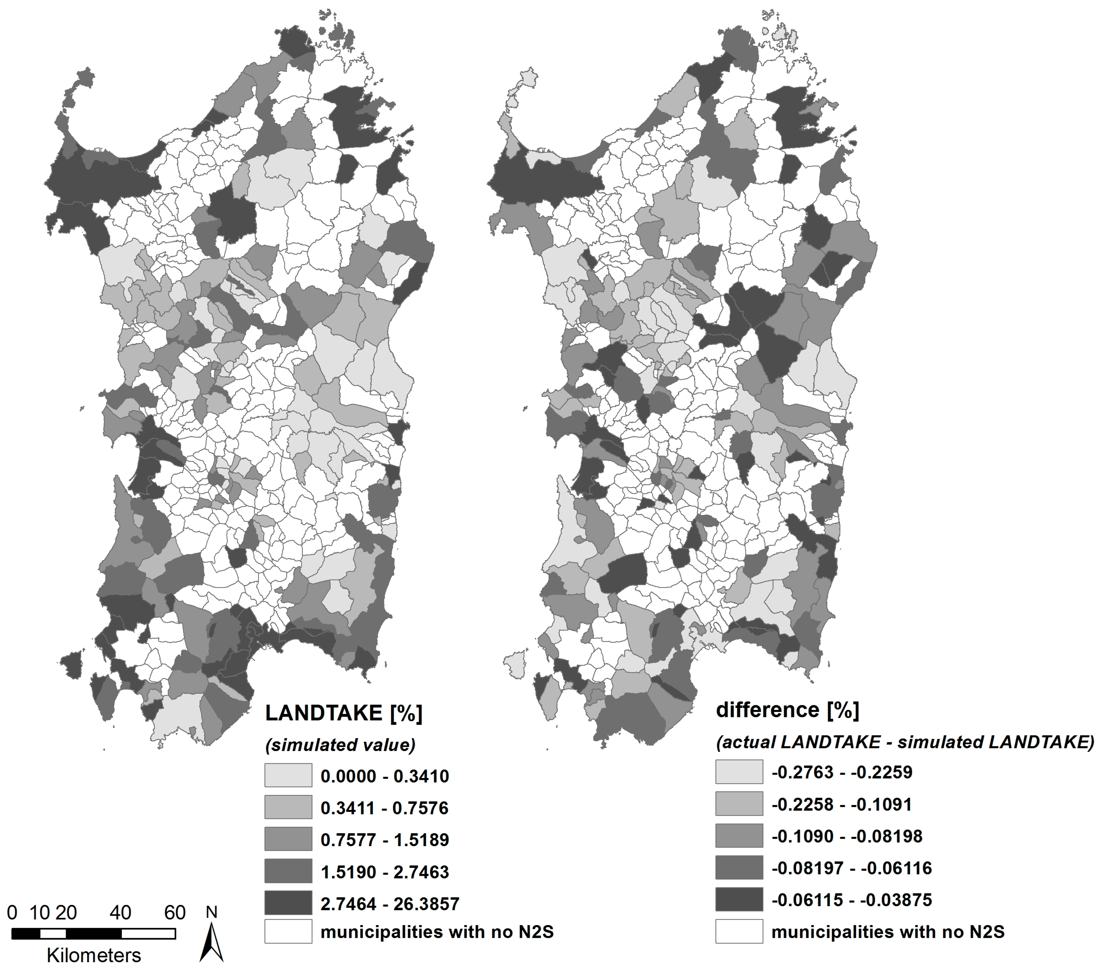
4.4. Scenario Building

Building upon the outcomes of the OSL models, that is, upon the results reported in Table 3, a “what-if” scenario was simulated. For each local authority, we calculated the magnitude of the effect on the 1990–2008 land take-related variable (LANDTAKE) that would have occurred if the covariate related to the size of N2Ss (that is, NAT_2000) had increased in each municipality by ten percentiles in that variable’s distribution.
Figure 9 visually presents the results of this scenario: to the left, the values of the simulated LANDTAKE variable are mapped (these can be compared and contrasted to the actual values, mapped in Figure 7), while to the right for each municipality we map the difference between actual and simulated values of LANDTAKE and show that an increase by ten percentiles in the share of municipal land included in N2Ss brings about a decrease in land take ranging from −0.03875 percent to −0.2763 percent.

5. Discussion and Conclusions

The outcomes of the regression model show an important and significant correlation, at the municipal level, between land take and the presence and size of N2Ss. Moreover, since the coefficients of the variables representing the factors that were tentatively assumed as determinants of land take are mostly significant and the goodness of fit of the model is relatively high (see Table 3), we can conclude that our research perspective is effective in explaining, in quantitative terms, the relationship between land take and the presence and size of N2Ss. Therefore, as regards the research issue we indicated in the introduction, the results of the implementation of our methodological framework provides the descriptive approaches of Mücher et al. [14], Hazeu et al. [16] and Martínez-Fernández et al. [10] with a substantial explanatory enhancement.
Our study puts in evidence four important implications concerning the relationship between land-taking processes and environmental protection policies related to the establishment and management of N2Ss.
First, our estimates highlight a robust negative influence of N2Ss on land take. This implies that, everything else being equal, the presence and size of N2Ss is correlated to a decrease in land take. The reduction in land take as a consequence of N2Ss is significant in quantitative terms.
Moreover, there is no evidence of the effect indicated by Dewi et al. [49] in the immediate neighborhoods of the boundaries of N2Ss, since the estimated marginal effects of N2Ss is positive in terms of the share of the municipal area that does not change its status from non-artificial to artificial. This implies that land saving spreads over the whole municipal land area as a consequence of the presence and size of the municipal N2Ss. Subsequently, our results show no sign of a somewhat strategic behavior on behalf of the municipalities, which do not seem to concentrate new developments outside the N2Ss, where conservation measures are not established. In other words, the presence and size of N2Ss seem to have a negative net effect on municipal land take. This finding is entirely consistent with the appropriate assessment-related policies whose implementation is mandatory for plans and projects which may possibly have negative impacts on conservation of species and habitats of N2Ss. According to the Habitats Directive, the appropriate assessment procedure must be applied not only in case of plans and projects concerning land parcels located within N2Ss, but also in case plans and projects related to areas outside the N2Ss boundaries, if such plans and projects may possibly damage habitats and species within the N2Ss.
A third important policy implication connected to the positive impact of Natura 2000-related policies on the conservation of the non-artificial status of land is that, because the impact of N2Ss-based environmental protection on land take is not related to other conservative planning rules, there is no need for severely restrictive planning codes, if N2Ss are properly established. Indeed, the establishment of N2Ss does not imply that there are land uses or developments which are forbidden in general terms. However, the mere presence of a N2S entails that developers, public administrations, planners, and practitioners, have to show that their projects or planning proposals will not damage or generate loss of habitats and/or species, which, according to the outcomes of our analysis, significantly reduces land-taking processes.
Fourth, a proximity effect does exist concerning N2Ss and urban areas. The closer urban areas are to N2Ss, the higher land take is detected in the municipal land area. This finding shows that pressure for land artificialization is much higher in the proximity of N2Ss when they are located near the already-urbanized areas, while it is comparatively weaker when they are far from the existing settlements.
The four points highlighted above entail important implications for planning policies, both at the local (municipal) and regional levels. A first consequence is that policies aiming at reducing land take should imply the establishment of new N2Ss, or the enlargement of existing ones. Both policies need effective and continuous cooperation of the local and regional administrations, since the complex and long-lasting time period concerning the establishment of new or enlarged N2Ss needs a substantial integration of planning visions on behalf of the local and regional authorities. Cooperation is necessary since the identification of conservation objectives and subsequent establishment of conservation measures, needed for a SCI to take the status of SAC under the provisions of the Habitats Directive [69], entails that the local authorities propose these measures, possibly in the context of a management plan, and the regional administration approves and brings to the attention of the National Office the approved proposal. Cooperation and integration of the local and regional planning processes would imply an important enhancement in the quality of Sardinian public planning, which has been characterized by a lack of coordination in recent years [70].
A second significant implication is that in public planning processes, especially at the municipal level, experts in nature conservation should systematically participate and cooperate with spatial planners and developers in the process of definition and approval of local plans, in order to support the identification of sites to be proposed for inclusion in the Natura 2000 Network. At present, this expertise is not considered as a necessary component of local planning teams [71].
Thirdly, particular attention should be paid to the possibility of proposing new N2Ss in the strategic environmental assessment processes of local plans. These processes entail the inclusion of objectives related to the protection of environmental resources and to the sustainability paradigm into the definition of spatial plans, which implies the possibility of the integration of such goals into the plan even though they were not considered in the first place [48].
Moreover, since the presence and size of N2Ss are effective against land take, conservation measures consistent with those adopted for the N2Ss could be extended over areas located outside SCIs, SPAs and SACs. From this perspective, complete and detailed maps concerning the spatial distribution of habitats are needed.
A fifth point is related to the necessity of a comprehensive coordination of conservation measures between plans of cities and towns whose municipal areas are adjacent to each other. From this point of view, a fundamental role should be played by the planning office of the regional administration, which coordinates local plans under the provisions of the Sardinian rules concerning the approval of regional and local plans [72].
Finally, as widely recognized in the literature, conservation measures may prevent the implementation of traditional land uses related to urbanization, agriculture and pastures, and, by doing so, they may possibly generate conflicts between local communities and municipal authorities [71,73]. The issues of information, participation and consensus-building should not be undervalued in the definition and implementation of local plans that entail conservation measures and policies against land take, and inclusive participatory processes should be carefully designed in detail long before plans are discussed and approved.
It has to be put in evidence that the econometric model we implement assesses the existence and magnitude of correlations between land take and the explanatory variables at the municipal level. It could be interesting, as a future development of our research, to implement studies which assume N2Ss as reference spatial units [11,74,75,76,77,78,79] and to compare outcomes and implied consequences.
Moreover, the availability of different land-use data at better resolution than the CLC maps could certain enhance the significance and explanatory power of the methodological approach here proposed.
Our methodology and results are based on regression models that include the presence of N2Ss as an explanatory variable and, as a consequence, our assessment needs the presence of N2Ss in the spatial units of our regression model. From this perspective, it has to be put in evidence that it would be interesting to detect what happens in municipalities where N2Ss are not established, but this issue is definitely outside the scope of our study. A promising further development of our research work would be to compare land-taking processes that occur in municipalities where N2Ss are established to those concerning municipal areas where they are not. Moreover, since the other side of the coin has not been explored yet, our findings and inferences should be cautiously considered in terms of points of reference for the definition and implementation of mitigating policies concerning land take.
A relevant issue related to the future development of our research work concerns the analysis of the non-stationarity of land take and its covariates. As we put into evidence above, the implementation of GWRs implies the availability of a much larger number of records than our 167 municipality-related observations. Information collected at the under-municipal level, which is not available at present, would possibly entail data related to small land parcels which change from a non-artificial to an artificial status. This would make our findings and inferences more robust.
Our results offer insights into the comprehensive character of land-taking processes, that is, into its features at the regional level. A substantial enhancement would be represented by analyses implemented at the local level, through the GWRs-based approach, which would make the inferences concerning the influence of the covariates on land take and the implied mitigation policies much more clear and robust.

Acknowledgments

This essay is written within the Research Program “Natura 2000: Assessment of management plans and definition of ecological corridors as a complex network”, funded by the Autonomous Region of Sardinia for the period 2015–2018, under the provisions of the Call for the presentation of “Projects related to fundamental or basic research” of the year 2013, implemented at the Dipartimento di Ingegneria Civile, Ambientale e Architettura [Department of Civil and Environmental Engineering and Architecture] (DICAAR) of the University of Cagliari, Italy.

Author Contributions

Sabrina Lai and Corrado Zoppi have made substantial contributions to the essay’s conception and design, introduction, discussion, and conclusions; Corrado Zoppi has especially taken care of Section 2, Section 3.2 and Section 4.2, whereas Sabrina Lai has especially taken care of Section 3.1, Section 4.1, Section 4.3 and Section 4.4.

Conflicts of Interest

The authors declare no conflict of interest.

Appendix A

Table A1. OLS results, dependent variables log(LANDTAKE): the regression model includes the logarithms of the covariates of Table 1.
VariableCoefficientSEt-StatisticHypothesis Test: Coefficient = 0
Constant−8.17732.4340−3.3600.0010
Log(NAT_2000)−0.12220.0439−2.7860.0060
Log(LT_N2000)2.32 × 10−51.30 × 10−51.7800.0771
Log(COASTRIP)2.26 × 10−51.54 × 10−51.4630.1456
Log(OLDPLAN)6.82 × 10−61.41 × 10−50.4820.6304
Log(WATER)1.85 × 10−51.13 × 10−51.6370.1037
Log(SLOPE)−0.03490.0438−0.7960.4274
Log(DENSITY1990)0.32360.07094.5610.0000
Log(INCOME2008)0.85410.28113.0390.0028
AUTOCORR0.16250.05812.7960.0058
Adjusted R2 = 0.5049.
Table A2. OLS results, dependent variable LANDTAKE: the regression model includes the covariates of Table 1, except COASTRIP and OLDPLAN.
VariableCoefficientSEt-StatisticHypothesis Test: Coefficient = 0
Constant0.03650.79450.0460.9634
NAT_2000−0.01480.0063−2.3660.0192
LT_N20000.01770.00483.6630.0003
WATER−0.00230.0005−4.4000.0000
SLOPE−0.03110.0107−2.8980.0043
DENSITY19900.00360.00113.1210.0021
INCOME20080.00020.00011.5880.1142
AUTOCORR0.79090.16344.8420.0000
Adjusted R2 = 0.5575.
Table A3. OLS results, dependent variable LANDTAKE: the regression model includes the covariates of Table 1, except OLDPLAN.
VariableCoefficientSEt-StatisticHypothesis Test: Coefficient = 0
Constant−0.05600.8099−0.0690.9450
NAT_2000−0.01410.0064−2.1970.0295
LT_N20000.01810.00493.7070.0003
COASTRIP−0.00010.0001−0.6190.5368
WATER−0.00220.0005−4.2290.0000
SLOPE−0.03040.0108−2.8070.0056
DENSITY19900.00350.00113.0630.0026
INCOME20080.00020.00011.6690.0972
AUTOCORR0.78960.16374.8240.0000
Adjusted R2 = 0.5555.
Table A4. OLS results, dependent variable LANDTAKE: the regression model includes the covariates of Table 1, except COASTRIP.
VariableCoefficientSEt-StatisticHypothesis Test: Coefficient = 0
Constant−0.10760.8085−0.1330.8943
NAT_2000−0.01300.0065−1.9960.0476
LT_N20000.01880.00503.7860.0002
OLDPLAN−0.00010.0001−0.9650.3359
WATER−0.00220.0005−4.2740.0000
SLOPE−0.02660.0117−2.2720.0245
DENSITY19900.00340.00122.9090.0042
INCOME20080.00020.99 × 10−41.6190.1075
AUTOCORR0.82060.16634.9360.0000
Adjusted R2 = 0.5572.

References and Notes

  1. In the words of the Habitats Directive (art. 1, letter k), an SCI is a “site which, in the biogeographical region or regions to which it belongs, contributes significantly to the maintenance or restoration at a favorable conservation status of a natural habitat […] and may also contribute significantly to the coherence of Natura 2000 […] and/or contributes significantly to the maintenance of biological diversity within the biogeographic region or regions concerned”.
  2. The Birds Directive (art. 4.1) states that “Trends and variations in population levels shall be taken into account as a background for evaluations. Member States shall classify in particular the most suitable territories in number and size as special protection areas for the conservation of these species in the geographical sea and land area where this Directive applies”.
  3. According to the Habitats Directive, natural habitats are “terrestrial or aquatic areas distinguished by geographic, abiotic and biotic features, whether entirely natural or semi-natural” (art. 1, letter b), conservation is “a series of measures required to maintain or restore the natural habitats and the populations of species of wild fauna and flora at a favorable status” (art. 1, letter a), and conservation status of a natural habitat is “the sum of the influences acting on a natural habitat and its typical species that may affect its long-term natural distribution, structure and functions as well as the long-term survival of its typical species within the territory” (art. 1, letter e).
  4. Art. 6, paragraph 3 of the Habitats Directive states that “any plan or project not directly connected with or necessary to the management of the site but likely to have a significant effect thereon, either individually or in combination with other plans or projects, shall be subject to appropriate assessment of its implications for the site in view of the site’s conservation objectives” and that “the competent national authorities shall agree to the plan or project only after having ascertained that it will not adversely affect the integrity of the site concerned and, if appropriate, after having obtained the opinion of the general public”.
  5. European Commission. Report on Best Practices for Limiting Soil Sealing and Mitigating Its Effects. 2011. Available online: http://ec.europa.eu/environment/archives/soil/pdf/sealing/Soil%20sealing%20-%20Final%20Report.pdf (accessed on 27 December 2016).
  6. European Environment Agency. The European Environment State and Outlook 2010—Land Use. 2010. Available online: http://www.eea.europa.eu/soer/europe/land-use/download (accessed on 27 December 2016).
  7. ISPRA. Il Consumo di Suolo in Italia [Land Take in Italy]. 2015. Available online: http://www.isprambiente.gov.it/files/pubblicazioni/rapporti/Rapporto_218_15.pdf (accessed on 27 December 2016). [Google Scholar]
  8. Foley, J.A.; de Fries, R.; Asner, G.P.; Barford, C.; Bonan, G.; Carpenter, S.R.; Chapin, F.S.; Coe, M.T.; Daily, G.C.; Gibbs, H.K.; et al. Global consequences of land use. Science 2005, 309, 570–574. [Google Scholar] [CrossRef] [PubMed]
  9. Turner, B.L.; Lambin, E.F.; Reenberg, A. The emergence of land change science for global environmental change and sustainability. Proc. Natl. Acad. Sci. USA 2007, 104, 20666–20671. [Google Scholar] [CrossRef] [PubMed]
  10. Martínez-Fernández, J.; Ruiz-Benito, P.; Zavala, M.A. Recent land cover changes in Spain across biogeographical regions and protection levels: Implications for conservation policies. Land Use Policy 2015, 44, 62–75. [Google Scholar] [CrossRef]
  11. Andam, K.S.; Ferraro, P.J.; Pfaff, A.; Sanchez-Azofeifa, G.A.; Robalino, J.A. Measuring the effectiveness of protected area networks in reducing deforestation. Proc. Natl. Acad. Sci. USA 2008, 105, 16089–16094. [Google Scholar] [CrossRef] [PubMed]
  12. Chape, S.; Harrison, J.; Spalding, M.; Lysenk, I. Measuring extent and effectiveness of protected areas as indicator for meeting global biodiversity targets. Philos. Trans. R. Soc. B 2005, 360, 433–455. [Google Scholar] [CrossRef] [PubMed]
  13. Ruiz-Benito, P.; Cuevas, J.A.; de la Parra, R.B.; Prieto, F.; Zavala, M.A. Land use change in a Mediterranean metropolitan region and its periphery: Assessment of conservation policies through CORINE Land Cover and Markov models. For. Syst. 2010, 19, 315–328. [Google Scholar] [CrossRef]
  14. Mücher, S.; Gerard, F.; Olschofsky, K.; Hazeu, G.; Luque, S.; Pino, J.; Gregor, M.; Wachowicz, M.; Halada, L.; Tompo, E.; et al. Spatial Impact of Conservation Sites (Natura 2000) on Land Cover Changes. In Proceedings of the 2nd Workshop of the EARSeL SIG on Land Use and Land Cover, Bonn, Germany, 28–30 September 2006; Braun, M., Ed.; European Association of Remote Sensing Laboratories and Center for Remote Sensing of Land Surfaces at the Rheinische Friedrich-Wilhelms-Universität Bonn: Bonn, Germany, 2006; pp. 386–393. [Google Scholar]
  15. CORINE is the acronym of COoRdination de l’INformation sur l’Environnement [Coordination of information concerning the environment].
  16. Hazeu, G.W.; Mücher, C.A.; Swetnam, R.; Gerard, F.; Luque, S.; Pino, J.; Halada, L. Historic Land Cover Changes at Natura 2000 Sites and Their Associated Landspaces Across Europe. In Proceedings of the 28th Symposium of the European Association of Remote Sensing Laboratories, Istanbul, Turkey, 2–5 June 2008; Maktav, D., Ed.; IOS Press: Amsterdam, The Netherlands, 2009; pp. 226–231. [Google Scholar]
  17. Pontius, R.G., Jr.; Shusas, E.; McEachern, M. Detecting important categorical land changes while accounting for persistence. Agric. Ecosyst. Environ. 2004, 101, 251–268. [Google Scholar] [CrossRef]
  18. Alo, C.A.; Pontius, R.G., Jr. Identifying systematic land-cover transitions using remote sensing and GIS: The fate of forests inside and outside protected areas of Southwestern Ghana. Environ. Plan. B Plan. Des. 2008, 35, 280–295. [Google Scholar] [CrossRef]
  19. MassGIS. 2002. Available online: http://www.mass.gov/anf/research-and-tech/it-serv-and-support/application-serv/office-of-geographic-information-massgis/datalayers/wbs2002.html (accessed on 27 December 2016).
  20. Zoppi, C.; Lai, S. Land-taking processes: An interpretive study concerning an Italian region. Land Use Policy 2014, 36, 369–380. [Google Scholar] [CrossRef]
  21. Zoppi, C.; Lai, S. Determinants of land take at the regional scale: A study concerning Sardinia (Italy). Environ. Impact Assess. 2015, 55, 1–10. [Google Scholar] [CrossRef]
  22. We focus on SCIs and SPAs only because at present no SACs have yet been established in Sardinia.
  23. For more details on the project, the reader can refer to the project’s website (in Italian only): http://www.bioitaly.casaccia.enea.it/wwwbioitaly/ (accessed on 31 March 2016).
  24. The list was approved with Decision of 19 July 2006—C(2006) 3261.
  25. Deliberation of the Regional Executive No. 52/19 of 15 December 2004. Available online: http://www.regione.sardegna.it/documenti/1_24_20050114100333.pdf (accessed on 27 December 2016).
  26. Deliberation of the Regional Executive No. 9/17 of 7 March 2007. Available online: http://www.regione.sardegna.it/documenti/1_73_20070326195223.pdf (accessed on 27 December 2016).
  27. The new format for the standard data forms was approved by the European Commission with Decision of 11 July 2011; standard data forms are available for every N2S through the European Environment Agency’s dedicated webpage: http://natura2000.eea.europa.eu/ (accessed on 27 December 2016).
  28. See for instance the raster map “Ecosystem Types of Europe”, available at http://www.eea.europa.eu/data-and-maps/data/ecosystem-types-of-europe (accessed on 27 December 2016).
  29. Information on this map (in Italian only) can be retrieved from the website of the Italian Superior Institute for Environmental Protection and Research: http://www.isprambiente.gov.it/it/servizi-per-lambiente/sistema-carta-della-natura/carta-della-natura-alla-scala-1–50.000/sardegna (accessed on 27 December 2016).
  30. This map is accessible through the Sardinian Regional Environmental Information System’s website (http://habitat.sardegnaambiente.it/). Registration and permits are required, because of the sensitivity of some information.
  31. European Environment Agency. Land Take. Available online: http://www.eea.europa.eu/data-and-maps/indicators/land-take-2/ (accessed on 27 December 2016).
  32. European Environment Agency. CORINE Land Cover. Available online: http://www.eea.europa.eu/publications/COR0-landcover (accessed on 27 December 2016).
  33. CORINE Land Cover 1990, 2000, 2006, 2012 raster maps (which concern respectively 25, 39, 37 and 33 countries) are available online: http://www.eea.europa.eu/data-and-maps/data/ (accessed on 27 December 2016); Italy is included in all of the databases.
  34. Diaz-Pacheco, J.; Gutiérrez, J. Exploring the limitations of CORINE Land Cover for monitoring urban land-use dynamics in metropolitan areas. J. Land Use Sci. 2014, 9, 243–259. [Google Scholar] [CrossRef]
  35. Bach, M.; Breuer, L.; Frede, H.G.; Huisman, J.A.; Otte, A.; Waldhardt, R. Accuracy and congruency of three different digital land-use maps. Landsc. Urban. Plan. 2006, 78, 289–299. [Google Scholar] [CrossRef]
  36. Aguilera-Benavente, F.; Botequilha-Leitão, A.; Díaz-Varela, E. Detecting multi-scale urban growth patterns and processes in the Algarve region (Southern Portugal). Appl. Geogr. 2014, 53, 234–245. [Google Scholar] [CrossRef]
  37. Siedentop, S.; Meinel, G. CORINE Land Cover 2000 in Nation-Wide and Regional Monitoring of Urban Land Use and Land Consumption. In UVA-Texte. 04/04 ISSN 0722–186X, Workshop CORINE Land Cover 2000; Leibniz-Institut für Ökologische Raumentwicklung e.V: Berlin, Germany, 2004; pp. 162–169. [Google Scholar]
  38. The spatial dataset is Available online: http://www.sinanet.isprambiente.it/it/sia-ispra/download-mais/consumo-di-suolo/carta-nazionale-consumo-suolo (accessed on 27 December 2016).
  39. European Environment Agency. Urban Morphological Zones 1990. Available online: http://www.eea.europa.eu/data-and-maps/data/urban-morphological-zones-1990-2 (accessed on 27 December 2016).
  40. SardegnaGeoportale. Land Use Map of Sardinia. Available online: http://www.sardegnageoportale.it/index.php?xsl=1598&s=291548&v=2&c=8831&t=1 (accessed on 27 December 2016). This dataset builds upon the so-called “2003 Land use map of Sardinia”, which is actually a land cover map that uses the CLC classification scheme at the 4th level (and, for some classes, the 5th level) in the hierarchy. Data were obtained mainly from photointerpretation of aerial photographs, satellite images, and orthoimages, but other vector data sets (e.g., regional digital cartography) were also used, together with onsite surveys. The scale of the dataset is 1:25,000 and the maps’ minimum mapping unit equals 0.5 ha in urban areas and 0.75 ha in rural areas.
  41. Feranec, J.; Jaffrain, G.; Soukup, T.; Hazeu, G. Determining changes and flows in European landscapes 1990–2000 using CORINE land cover data. Appl. Geogr. 2010, 30, 19–35. [Google Scholar] [CrossRef]
  42. Kallimanis, A.S.; Touloumis, K.; Tzanopoulos, J.; Mazaris, A.D.; Apostolopoulou, E.; Stefanidou, S.; Pantis, J.D. Vegetation coverage change in the EU: Patterns inside and outside Natura 2000 protected areas. Biol. Conserv. 2015, 24, 579–591. [Google Scholar] [CrossRef]
  43. Kuemmerle, T.; Olofsson, P.; Chaskovskyy, O.; Baumann, M.; Ostapowicz, K.; Woodcock, C.E.; Radeloff, V.C. Post-soviet farmland abandonment, forest recovery, and carbon sequestration in Western Ukraine. Glob. Chang. Biol. 2011, 17, 1335–1349. [Google Scholar] [CrossRef]
  44. Radović, A.; Bukovec, D.; Tvrtković, N.; Tepić, N. Corine land cover changes during the period 1990–2000 in the most important areas for birds in Croatia. Int. J. Sustain. Dev. World 2011, 18, 341–348. [Google Scholar] [CrossRef]
  45. ISTAT (Italian National Institute of Statistics). Basi Territoriali e Variabili Censuarie. Available online: http://www.istat.it/it/archivio/104317 (accessed on 27 December 2016).
  46. ISTAT (Italian National Institute of Statistics). Descrizione dei Dati Geografici e delle Variabili Censuarie Delle Basi Territoriali per i Censimenti: Anni 1991, 2001, 2011. [A Description of Geographic Data and Census Variables of Spatial Reference Datasets for National Census: Years 1991, 2001 and 2011], 2016. Available online: http://www.istat.it/it/files/2013/11/Descrizione-dati-Pubblicazione-2016.03.09.pdf (accessed on 27 December 2016).
  47. European Commission, DG Environment. Assessment of Plans and Projects Significantly Affecting Natura 2000 Sites. Methodological Guidance on the Provisions of Article 6(3) and (4) of the Habitats Directive 92/43/EEC. Subparagraph 5 of paragraph 3.2 and paragraphs 3.3 and 3.4. Available online: http://ec.europa.eu/environment/nature/natura2000/management/docs/art6/natura_2000_assess_en.pdf (accessed on 27 December 2016).
  48. Zoppi, C.; Lai, S. An Ontology of the appropriate assessment of municipal master plans related to Sardinia (Italy). Future Internet 2014, 6, 223–241. [Google Scholar] [CrossRef] [Green Version]
  49. Dewi, S.; van Noordwijk, M.; Ekadinata, A.; Pfund, J.L. Protected areas within multifunctional landscapes: Squeezing out intermediate land use intensities in the tropics? Land Use Policy 2013, 30, 38–56. [Google Scholar] [CrossRef]
  50. Meyfroidt, P.; Lambin, E.F.; Erb, K.H.; Hertel, T.W. Globalization of land use: Distant drivers of land change and geographic displacement of land use. Curr. Opin. Environ. Sustain. 2013, 5, 438–444. [Google Scholar] [CrossRef]
  51. Forster, D.L. An Overview of U.S. Farm Real Estate Markets. Working Papers of the Department of Agricultural, Environmental and Development Economics, Ohio State University. AEDE-WP-0042-06. 2006. Available online: http://ageconsearch.umn.edu/bitstream/28319/1/wp060042.pdf (accessed on 27 December 2016).
  52. Guiling, P.; Brorsen, B.W.; Doye, D. Effect of urban proximity on agricultural land values. Land Econ. 2009, 85, 252–264. [Google Scholar] [CrossRef]
  53. Huang, H.; Miller, Y.; Sherrick, B.J.; Gòmez, M.I. Factors influencing Illinois farmland values. Am. J. Agric. Econ. 2006, 88, 458–470. [Google Scholar] [CrossRef]
  54. Sklenicka, P.; Molnarova, K.; Pixova, K.C.; Salek, M.E. Factors affecting farmlands prices in the Czech Republic. Land Use Policy 2013, 30, 130–136. [Google Scholar] [CrossRef]
  55. Zoppi, C.; Lai, S. Empirical Evidence on Agricultural Land-Use Change in Sardinia, Italy, from GIS-Based Analysis and a Tobit Model. Cartographica 2012, 47, 211–227. [Google Scholar] [CrossRef]
  56. Anselin, L. Spatial Econometrics: Methods and Models; Kluwer Academic Publishers: Dordrecht, The Netherlands, 1988. [Google Scholar]
  57. Anselin, L. Spatial Econometrics. In A Companion to Theoretical Econometrics; Baltagi, B.H., Ed.; Blackwell Publishing: Oxford, UK, 2003; pp. 310–330. [Google Scholar]
  58. The CORINE Land Cover 1990 map is available at http://www.eea.europa.eu/data-and-maps/data (accessed on 27 December 2016).
  59. Available from the Regional Geoportal. Available online: http://www.sardegnageoportale.it/index.html (accessed on 27 December 2016).
  60. Calculated using population data available at http://www.comuni-italiani.it (official statistical website of the Italian municipalities) and at http://demo.istat.it/dat81-91/COMUNI/ind_pro.htm (official website of the Italian National Institute of Statistics—ISTAT) (accessed on 27 December 2016).
  61. Data retrievable from the official website of the Italian Ministry of Economy and Finance: http://www1.finanze.gov.it/finanze2/analisi_stat/v_4_0_0/contenuti/Redditi_e_principali_variabili_IRPEF_su_base_comunale_CSV_2008.zip?d= (accessed on 27 December 2016).
  62. University of Chicago—Center for Spatial Data Science. Software Downloads. Available online: https://spatial.uchicago.edu/software (accessed on 27 December 2016).
  63. Our findings are not entirely consistent with land take-related data made available by ISPRA at http://www.isprambiente.gov.it/files/comunicati-stampa/2014/Tabelle_consumo_di_suolo.pdf/at_download/file (accessed on 27 December 2016).
  64. Sander, H.A.; Zhao, C. Urban green and blue: Who values what and where? Land Use Policy 2015, 42, 194–209. [Google Scholar] [CrossRef]
  65. Akaike, H. A new look at the statistical model identification. IEEE Trans. Autom. Control 1974, 19, 716–723. [Google Scholar] [CrossRef]
  66. Fotheringham, A.S.; Brunsdon, C.; Charlton, M.E. Geographically Weighted Regression: The Analysis of Spatially Varying Relationships; John Wiley and Sons: West Sussex, UK, 2002. [Google Scholar]
  67. Yu, D.; Wei, Y.D.; Wu, C. Modeling spatial dimensions of housing prices in Milwaukee, WI. Environ. Plan. B 2007, 34, 1085–1102. [Google Scholar] [CrossRef]
  68. The “Geographically Weighted Regression (GWR) (Spatial Statistics)” section, related to Fotheringham et al. (2002), of ArcGIS Resources—ArcGIS 10.1, highlights that “GWR should be applied to datasets with several hundred features for best results. It is not an appropriate method for small datasets: http://resources.arcgis.com/en/help/main/10.1/index.html#/Geographically_Weighted_Regression_GWR/005p00000021000000/ (accessed on 27 December 2016).
  69. The reader can refer to the following notes released by the European Commission “Commission Note on Setting Conservation Objectives for Natura 2000 Sites” and “Commission Note on Establishing Conservation Measures for Natura 2000 Sites”, available at: http://ec.europa.eu/environment/nature/natura2000/management/docs/commission_note/commission_note2_EN.pdf and http://ec.europa.eu/environment/nature/natura2000/management/docs/commission_note/comNote%20conservation%20measures_EN.pdf (accessed on 27 December 2016).
  70. Zoppi, C.; Lai, S. Assessment of the Regional Landscape Plan of Sardinia (Italy): A participatory-action-research case study type. Land Use Policy 2010, 27, 390–405. [Google Scholar] [CrossRef]
  71. Leone, F.; Zoppi, C. Conservation measures and loss of ecosystem services: A study concerning the Sardinian Natura 2000 Network. Sustainability 2016, 8, 1061. [Google Scholar] [CrossRef]
  72. The prerogatives of the regional administration concerning the approval of local plans are laid down in Art. 9 of Sardinian Regional Law No. 28/98.
  73. Kovács, E.; Kelemen, K.; Kalóczkai, A.; Margóczi, K.; Pataki, G.; Gébert, J.; Málovics, G.; Balázs, B.; Roboz, A.; Krasznai Kovács, E.; et al. Understanding the links between ecosystem service trade-offs and conflicts in protected areas. Ecosyst. Serv. 2015, 12, 117–127. [Google Scholar] [CrossRef]
  74. Figueroa, F.; Sánchez-Cordero, V. Effectiveness of natural protected areas to prevent land use and land cover change in Mexico. Biodivers. Conserv. 2008, 17, 3223. [Google Scholar] [CrossRef]
  75. Nagendra, H. Do parks work? Impact of protected areas on land cover clearing. Ambio 2008, 37, 330–337. [Google Scholar] [CrossRef] [PubMed]
  76. Vasconcelos, M.J.P.; Mussá Biai, J.C.; Araújo, A.; Diniz, M.A. Land cover change in two protected areas of Guinea-Bissau (1956–1998). Appl. Geogr. 2002, 22, 139–156. [Google Scholar] [CrossRef]
  77. Joppa, L.N.; Loarie, S.R.; Pimm, S.L. On the protection of protected areas. Proc. Natl. Acad. Sci. USA 2008, 105, 667–6678. [Google Scholar] [CrossRef] [PubMed]
  78. Joppa, L.N.; Pfaff, A. Global protected area impacts. Proc. R. Soc. B Biol. Sci. 2011, 278, 1633–1638. [Google Scholar] [CrossRef] [PubMed]
  79. Geldmann, J.; Barnes, M.; Coad, L.; Craigie, I.D.; Hockings, M.; Burgess, N.D. Effectiveness of terrestrial protected areas in reducing habitat loss and population declines. Biol. Conserv. 2013, 161, 230–238. [Google Scholar] [CrossRef]
Figure 1. Spatial layout of the Natura 2000 network in Sardinia as of 2007.
Sustainability 09 00259 g001
Figure 2. Spatial distribution of habitats of community interest in Sardinia: type 2 “Coastal sand dunes and inland dunes” and type 9 “Forests”. A “type” here corresponds to the set of habitat codes listed in Annex I of the Habitats Directive that begin with the same first-level digit.
Sustainability 09 00259 g002
Figure 3. Spatial distribution of habitats of community interest within the site of community interest (SCI) “ITB 020015—Area del Monte Ferru di Tertenia” as mapped in 2013 within the regional project titled “Monitoring the conservation status of habitats and species of community interest within Natura 2000 sites (N2S) in Sardinia”, funded through the ERDF (European Regional Development Fund), Sardinian Regional Operational Program for the 2007–2013 period. Habitats are coded following the nomenclature provided in Annex I of the Habitats Directive and grouped together when two or more habitats are intertwined. The asterisk indicates priority habitats, as defined in Article 1 and listed in Annex I of the Habitats Directive.
Sustainability 09 00259 g003
Figure 4. Analysis of changes in artificial land cover between 1990 and 2008: an example showing correction of inconsistencies due to differences in the two maps’ resolutions.
Sustainability 09 00259 g004
Figure 5. Cartographical visualization of some issues arising when using census data to assess land take (time interval: 1991–2011): (a) boundaries in the 1991 map are much coarser than in the 2011 map; (b) industrial areas and transport facilities are not mapped in the 1991 map (the oil refinery showed in the map was built in the 1960s); (c) a number of hamlets mapped in 1991 are not mapped in 2011; (d) artificial areas, such as detached buildings in the countryside that can be detected in the regional CORINE land cover (CLC) map are not mapped, per se (they belong to the class “area with sparse buildings”, together with forests, beaches or agricultural areas without any buildings).
Sustainability 09 00259 g005
Figure 6. Land take between 1900 and 2008 at the local scale in Sardinia: an example from five municipalities.
Sustainability 09 00259 g006
Figure 7. Spatial distribution of the dependent variable LANDTAKE (quantiles). Grey polygons represent municipalities whose territory overlaps at least one Natura 2000 site; darker shades of grey correspond to increasing significance of land take per unit of municipal land area.
Sustainability 09 00259 g007
Figure 8. Spatial distribution of the three potential drivers having the highest correlation coefficient (all quantiles). Grey polygons represent municipalities whose territory overlaps at least one Natura 2000 site; darker shades of grey correspond to increasing significance of each driver.
Sustainability 09 00259 g008
Figure 9. Spatial distribution of policy implications: ratio of the total municipal area whose land cover would have changed from non-urbanized to urbanized between 1990 and 2008 to the municipal land area if an increase in size of N2Ss had occurred (left) and difference between actual and simulated values of LANDTAKE (right) (both quantiles). Polygons represent municipalities.
Sustainability 09 00259 g009
Table 1. Definition of variables related to land take in the period 1990–2008 and covariates, and descriptive statistics (for all the variables, the spatial unit is the municipal administrative land area).
VariableDefinitionMeanSD.
LANDTAKERatio of the total municipal area whose land cover changed from non-urbanized to urbanized between 1990 and 2008 to the municipal land area (%, ha/ha) (sources: CORINE Land Cover 1990, next CLC90 [58]; 2008 Regional CORINE Land Cover Map, level 1, next CLCMS08 [59])1.862.45
NAT_2000Ratio of the total municipal land area belonging to the Natura 2000 network in 2008 to the municipal land area (%, ha/ha) (source: Spatial Dataset of the Regional Geographic Information System of Sardinia, next SDRGISS [59])31.1624.65
LT_N2000Total municipal area whose land cover changed from non-urbanized to urbanized between 1990 and 2008 within the Natura 2000 network (ha) (sources: CLC90; CLCMS08; SDRGISS)20.4035.07
COASTRIPMunicipal land area classed as Natura 2000 and included in the coastal strip (ha) (sources: SDRGISS; Regional Landscape Plan’s spatial dataset [59])690.231785.09
OLDPLANMunicipal land area classed in planning code in force before 2006 as areas where land transformations and new developments were almost totally forbidden (ha) (source: SDRGISS)1357.252558.73
WATERTotal municipal area classed as 4 “Wetlands” or 5 “Water bodies” in the 2008 regional land-use map and included in the Natura 2000 network (ha) (source: SDRGISS)114.83388.38
SLOPEMunicipality’s weighted average slope of areas included in the Natura 2000 network; weight = area of the share of the municipality designated as Natura 2000 site(s) (%) (source: SDRGISS)18.8513.30
DENSITY1990Municipality’s residential density in 1990 (residents/km2) [60]77.85194.62
INCOME2008Municipality’s per-capita income in 2008 (€) [61]7442.911727.64
AUTOCORRMunicipality’s spatially lagged dependent variable 1990–2008 (ref: LANDTAKE)1.671.16
Table 2. Pearson product-moment correlation coefficients between the dependent variable (LANDTAKE) and all of the covariates listed in Table 1.
Variableρ
NAT_2000−0.192
LT_N20000.415
COASTRIP0.054
OLDPLAN−0.038
WATER0.172
SLOPE−0.279
DENSITY19900.439
INCOME20080.483
AUTOCORR0.591
Table 3. Ordinary least squares (OLS) results, dependent variable LANDTAKE: the regression model includes the covariates of Table 1.
VariableCoefficientSEt-StatisticHypothesis Test: Coefficient = 0
Constant−0.10400.8137−0.1280.8985
NAT_2000−0.01300.0066−1.9900.0484
LT_N20000.01880.00503.7740.0002
COASTRIP6.52 × 10−60.00010.0560.9551
OLDPLAN−6.46 × 10−58.74 × 10−5−0.7400.4607
WATER−0.00220.0005−4.2320.0000
SLOPE−0.02640.0121−2.1910.0300
DENSITY19900.00340.00122.8900.0044
INCOME20080.00020.00011.5670.1192
AUTOCORR0.82240.16984.8430.0000
Adjusted R2 = 0.6441.
Table 4. Student’s t-test results (variable LANDTAKE).
Threshold 1: 250 mThreshold 2: 500 mThreshold 3: 750 mThreshold 4: 1000 m
Group 1 (D < 250 m)Group 2 (D > 250 m)Group 1 (D < 500 m)Group 2 (D > 500 m)Group 1 (D < 750 m)Group 2 (D > 750 m)Group 1 (D < 1 km)Group 2 (D > 1 km)
Mean2.350651.322402.216881.337902.167291.263542.088611.32390
Variance9.596581.559608.658061.703358.286821.065727.913961.13303
Observations8879100671115611849
t stat2.865162.626392.952622.54632
p-value0.002470.004770.001820.00590
D: minimum distance between a main settlement belonging to a given municipality and the closest N2S.

