
Rediscovering Rural Territories by Means of Religious Route Planning

1
Department of Agriculture, University of Sassari, Sassari 07100, Italy
2
Department of Architecture, Design and Urban Planning, University of Sassari, Sassari 07100, Italy
*
Author to whom correspondence should be addressed.
Sustainability 2017, 9(3), 363; https://doi.org/10.3390/su9030363
Submission received: 20 December 2016
/
Revised: 16 February 2017
/
Accepted: 22 February 2017
/
Published: 2 March 2017
(This article belongs to the Special Issue Decipher the Present to Shape the Future- Rethinking the Urban–Rural Nexus)
Abstract
:Since ancient times, pilgrimages have been an important expression of faith because slow-paced traveling, physical effort, and a closer relationship with nature favor introspection. Protecting pilgrimage routes means transforming them into a medium to rediscover and guide landscape development while avoiding possible speculative drifts. Such an approach is particularly important in rural areas often relegated to a marginal role in planning strategies, but frequently traversed by these itineraries. This paper deals with pilgrimage routes in Sardinia (Italy) and their chance to become an integral part of composite territorial infrastructures for triggering regeneration processes in rural areas. First, we introduce the topic with reference to planning literature and various case studies. Then, we select four pilgrimage itineraries that extend through different parts of the island, and compare them using a set of indicators regarding landscape, accessibility, visibility, equipment, planning, and management. A composite index has been developed to classify paths with respect to their potential to become part of a system of greenways, providing facilities and benefits to surrounding areas. The analysis highlights the strengths and weaknesses of local realities. It underlines factors, such as intrinsic characteristics of territories, local management, and decision-making circumstances, which affect trail potentialities to activate greenway projects to trace a new development perspective for rural areas.
1. Introduction
In recent years, there has been an increased interest in the institution of pilgrimage routes in Europe and Italy [1,2]. The number of pilgrimage route travelers is constantly growing. Besides pilgrims, hikers with other motivations such as travel, sport, or simply the challenge of walking in a foreign land utilize these routes as well. Pilgrimage is a personal and spatial experience that involves a special contact with the traversed environment. Walking off the beaten track, away from the habitual life scene and its frenetic rhythm [3], encourages spiritual engagement and the achievement of a personal inner dimension. This experience places local people, landscapes, resources, and past and present signs of local identities in contact with territories. The “cammino” is, therefore, considered to be a spiritual experience, a personal journey conducive to the discovery of oneself as well as of unknown places. Pilgrimage routes combine two different motivations: one related to the emotional experience of its visitors, such as the desire to escape, rest, and relax and the need for spiritual introspection [4]; the other related to destinations and route characteristics such as attractiveness of local sites, cultural attractions and infrastructures [5]. Many popular pilgrimage routes (Cammino de Santiago, Via Francigena) turned out to be a great opportunity for growth and development for local contexts [6,7].
These routes encouraged many local initiatives of territorial recovery and rehabilitation over the years, and the start-up of numerous service activities designed to support and enrich the travel of pilgrims. In this sense, religious walks became structural components of the local economy and organizations. In the most successful experiences, a crucial factor was the continuous action of integration and coordination between different levels and bodies involved in the process. Furthermore, a coordination effort is required to guarantee the combination of policies related to active conservation, territorial system regeneration, and cultural and religious tourism promotion. The purpose of this coordination effort is to conceive planning and management tools to protect these areas against the risks of mass tourism homologation.
Several successful regeneration processes have been carried out through greenway projects [8,9,10] intended as multi-functional public pathways for slow mobility, characterized by ecological, tourism, recreation, and education value. According to Pezzagno and Chiaf [11], “Greenway is a system of routes dedicated to non-motorized circulation able to connect the population with the natural, agricultural, landscape and historic-cultural resources of their region and with the urban life centers both in cities and rural areas”. It differs from “itinerary” which refers to “signposted resources in a territory that aren’t connected a structured way” as well as from “trail”, conceived as “a simple/complex structured and equipped route for joining in a physical way the territorial resources”.
According to these definitions, existing trails and their landscape elements (both natural and human-made features including those with religious or heritage value) represent the basic components of a potential greenway which, however, remains inactive if its elements are not properly interlinked. In other words, to act as a greenway, a spatial setting requires its own components to function in a systemic way, weaving synergies between functions, activities, spatial elements and players. Examples of synergy are the combination between agriculture and tourism (accommodations hosted in farmlands) or the connection between settlements and natural elements with recreational and educational uses. Due to their widespread extension and their capability to connect tangible and intangible features of contexts (physical places, flows, environmental resources, cultural values, people), existing trails represent suitable environments for the establishment of sustainable relationships between local components. Therefore, one favorable operative approach appears to focus on coexistence, integration, and communications among territorial dimensions. For this reason, greenway policies consist of mixed actions aimed at creating physical, social, and economic correspondences in involved areas. These policies combine interventions to arrest decay processes and to re-establish environmental dynamics, actions to recover and give new value to historical and cultural heritage and initiatives to rediscover local human resources and promote new uses. Greenways help to improve the integrity of the landscape, not only by stemming the loss of natural features, but also by engendering new natural and social functions. In this manner, they trigger local regeneration and not merely rehabilitation by increasing the accessibility, attractiveness, usability and identifiability of local public goods.
In line with this approach, in 2012, the Autonomous Region of Sardinia instituted various pilgrimage routes across the island with the aim of promoting them as opportunities for local enhancement and development. The paper examines five of these routes by exploring their generative potential on local contexts.
2. Method
The first question we investigated regards the minimal requirements a pilgrim route must possess to become a catalyst for territorial regeneration. Specialized literature in the field of sustainable planning highlights the following features:
- Accessibility;
- Path attractiveness;
- Visibility;
- Planning and management.
Accessibility is conceived as the availability and usability of an existent infrastructural network of pathways. The first requirement is the presence of an extensive network of tracks and secondary paths to which pilgrimage routes can grasp. Walking along off-beaten tracks allows the possibility to discover unknown places and aspects of local identity that would be difficult to perceive along more conventional itineraries. Fundamental qualities of the network are: how easy can the route be reached, the degree of difficulty (length and slope), the state of track surface, public or private ownership, the accessibility for a wide range of users (e.g., children, elderly, disabled, expert walkers), and travel modes. Walkability is essential to distinguish the pilgrim experience from the more ordinary attitude of visitors and tourists. At the same time, the possibility to combine walking with other slow mobility modes (e.g., cycling, on horseback) enhances accessibility, extending the target of potential users. It has been demonstrated that reachability, extensions, slope, maintenance of pathways, and the presence of equipment along the route strongly influence non-motorized travel behaviors [12] and the propensity of people to stroll. Connectivity intended as the value of each route in providing access to unique places (e.g., natural, historical or archaeological sites), and central destinations (human settlements) represent another important accessibility factor to consider [13].
The attractiveness of the path is related to the quality of the traversed environment, and to the experience of freely walking and discovering unknown areas. In this sense, side facilities and services (e.g., fountains, rest areas, attractions) play a crucial role: their abundance alongside the pathways support the experience of pilgrimage itself as well as the development of traversed territories. Studying satisfaction and motivation of scenic route users, Denstadli and Jacobsen [14] identified the relevance of factors related to “visual” and “activity based” experiences, the first being depicted by elements such as “beautiful view, interesting landscape, and natural attractions”, the second by cultural and nature-based activities along the route (e.g., local identity attractions, service areas, outdoor recreations). If regarded as tourism routes, pilgrimage pathways should include not only the road itself and its surrounding landscapes and attractions, but also pertaining facilities including rest areas, toilets, and parking, and adjacent hospitality receptive services such as eating areas and overnight accommodation. These characteristics are particularly important on longer routes.
The visibility refers to the availability of information about the religious route and its traversed areas both via media and directly on site. The ease to obtain clear information through internet, conventional magazines, books, promotional materials, fosters the dissemination of knowledge about the history of the route, landscape features, cultural values, encountered along the way. Interpretive media like maps or video sharing encourage visitors and help them along the course. Demarcation of routes and additional signposts describing heritage assets and indicating facilities contribute to enhancing path readability, providing a recognizable image and supporting users in their experience. Especially along off-road segments, it is important for hikers to have the certainty of being on the right course as well as to have information about available surrounding attractions and opportunities. Promotional campaigns by means of conventional and new media are important vectors of information that affect the visibility of routes among potential users [15].
With regard to planning and management Lourens [15] remarked the importance of a macro-level strategic plan as a result of consultations and agreements between different levels of planning concerning future plans for the area. The involvement of the private sector, particularly local stakeholders such as entrepreneurs and organizations, is a key determinant that facilitates pilgrimage routes to be catalysts of local regeneration. The above situation requires, therefore, local development partnerships in the ongoing management of greenways, as well as the availability of funds for implementing actions of preservation and rehabilitation of routes and connected heritage assets. The Hidden Britain Project in England suggests that local community ownership of process is fundamental for the sustainability of the process. The approach developed through the Church of England in rural areas seeks engagement with communities to help them face problems of declining rural economies and industries. The intention is to provide a different and more meaningful visitor experience based on a deeper immersion with local rural community life. “Whilst not attempting to grow mainstream or mass tourism in these areas, the project has quietly and effectively evolved a niche market. If this brings economic benefit so that local shops, post offices, petrol stations and village pubs remain open, then for these communities the urban drift may have been halted” [16].
Assuming this conceptual frame, the paper proposes an analytical method to assess the potential of pilgrim walks to become operational vectors of regional development. From a methodological perspective, the complexity of the topic stimulated the adoption of a multi-dimensional and integrated approach. We believe an inclusive, multi-indicator approach can help understanding the links between local peculiarities. Thus, a composite index called ITP (index of territorial potentiality) was developed.
Operationally, the construction of the ITP index was based on the combination of the Joint Research Center procedure [17] with semi-structured interviews with experts (Figure 1).
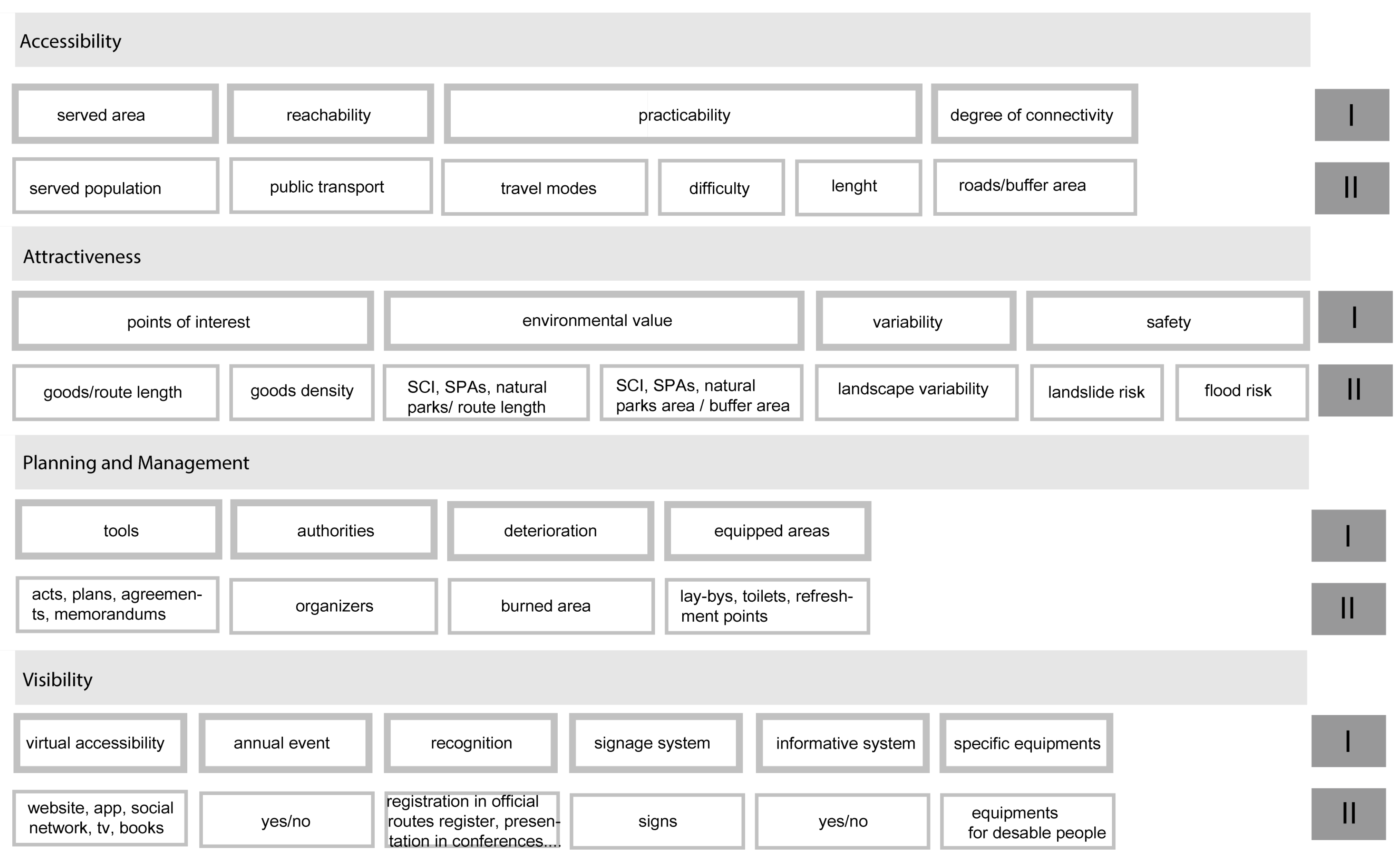
To be more precise, an initial set of indicators referred to the four aforementioned macro-categories derived from the literature (accessibility, attractiveness, planning and management, visibility) was defined by the authors. As shown in Figure 2, each macro-category was split into sub-items considered as useful variables for measuring the route contribution to the corresponding dimension.
A panel of experts supported the authors to validate the dataset of attributes and to estimate their relative importance. Four scholars in the field of regional planning, ecology, tourism economy, and transportation, with extensive experience in research and planning processes, demonstrated by publications and professional assignments at regional and international levels, were involved in a two-step interview.
First, an open-ended interview with specialists was conducted in October 2014 with the purpose of discussing the dataset of attributes. This first round of consultation considered all four macro-categories as equally important for the evaluation of the potential of development of the path. Furthermore, scholars suggested excluding some indicators that were originally listed (Figure 2) because of data redundancy. As an example, the number of heritage goods per route length was omitted because the density measure of goods was already included this information. The final set of indicators used for the analysis of the religious walks is described in Table 1, which gives details of the measurement methods and data sources utilized.
A second phase of the survey with experts consisted in the assignment of weights to indicators. Specialists were asked to rank each variable by use of a pair-wise comparison matrix. The indicators of each macro-category were compared to each other based on their reciprocal importance (i.e., experts established if each indicator was more important, less important, or equal to the compared others). Then, single weights were obtained by dividing the sum of the scores of each row of the matrix with the weight related to the corresponding macro-category (exact weight 0.25, according to the equal influence assigned in the computation of the total score of ITP). Table 2 gives an insight of the procedure followed, with the pair-wise comparison matrices for the four macro-categories.
In order to calculate the ITP index, the selected indicators were normalized by subtracting the minimum value from each value of distribution and dividing the result by the range of variation, in order to transform the original value in scores between 0 and 1. Normalized indicators were then aggregated in the form of a weighted summation. The obtained composite indicator provides a global information of the analyzed phenomenon representing an important reference in the interpretation of the study context and a starting point for further investigation. Table 3 reports normalized values of attributes for each pilgrimage route and the final classification (ranking in bold font).
A sensitivity analysis was then conducted to test the robustness of the model and suggested possible actions to improve the performance of the weakest routes.
3. Application to Sardinian Religious Routes. Main Results
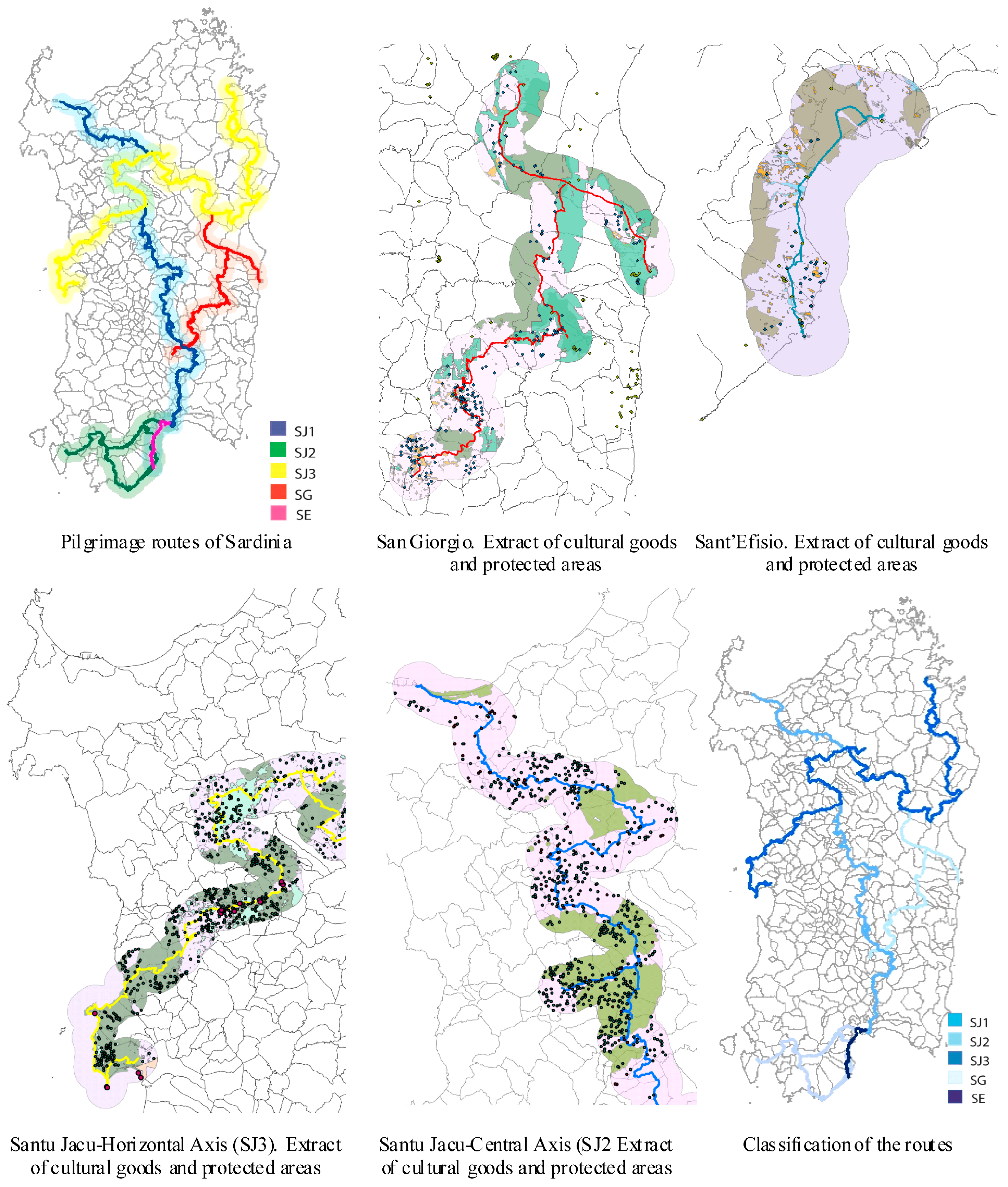
In 2012, the Region of Sardinia instituted a register of religious routes. The initiative is part of the “Identity, Cultural and Religious Tourism” program intended to enter the Region within national and international networks and generate a structured tourism offer capable of attracting significant flows of visitors, especially during off-season periods, by supporting events with a strong connotation of identity. The goal of the program is “to describe in a unified way paths, routes, destinations and the most important religious monuments through the development and promotion of the island” [18]. However, the availability of data and structured information related to these routes is still lacking. It has been necessary, therefore, to build information ex novo, making use of different sources (Table 1). The variety of data caused difficulties in reaching the same level of detail for all considered pathways; in particular, it was not possible to recreate the route of Santa Barbara (SB), which was not classified at the time of the research. Furthermore, some attributes originally included were abandoned due to the impossibility of collecting data with the resources available at the time of the study, but potentially achievable in further development of the research. Regarding the route of Santu Jacu (SJ), due to its geographical extension, it was divided into three sections (SJ1–3) (Table 4).
Based on the IPT index values (Table 3), the route of Sant’Efisio has the greatest potential to become an element of territorial development, followed by the horizontal axis of Santu Jacu (SJ3). The route of San Giorgio (SG) has the lowest performance (Figure 3).
Comparing this result with the executed territorial analysis, it was possible to comment about the reasons behind the outcome:
- Origin and history. The route of SE has a long tradition consolidated over 350 years of history. Stages remained unchanged over time and objective evidence in documented events has been found. In addition to the folkloric character, the route maintained a strong religious connotation. In the case of other routes, the philological reconstruction was present, but less certain, and became secondary compared to the explicit desire to promote knowledge and to enhance the culture of crossed territories;
- Investment. Material and emotional investments supported by municipalities and the local population involved in the route of SE have been constant and significant over the years. In 2014, the Region of Sardinia allocated €300,000 and the city of Cagliari contributed €212,000. The estimated number of participants was 100,000 people. Even for the route of SJ, a strong motivation prompted promoters to actively engage in the implementation of the project (procedure establishment, path definition and marking, installation of signposts, facilities management);
- Visibility. The route of SE is fully embedded in an international network of religious and cultural events that enhance the path’s popularity and notoriety. Associations from almost all Sardinian municipalities are called to take part in the parade. In 2014, the promotional investment amounted to €150,000. A strong technical direction accompanied the event. To a lesser extent, the route of Santu Jacu also boasts good visibility thanks to the intense promotional activity based on traditional and new media (social networks, Internet, thematic sites). However, with respect to the route of SE, its dissemination is still limited to groups of devotees also because of its recent introduction (since 2012);
- Recognition. In Mediterranean countries, apart from the processions that take place in Spain similar to SE in value and durability, the route of SE is acknowledged to be one of the most significant routes for its length, the number of communities involved and the typical costumes. The rich ethnographic heritage, along with the strong devotion demonstrated over the years by pilgrims, is the basis of the request for recognition and inscription on the Representative List of the Intangible Cultural Heritage of Humanity submitted to the UNESCO. The affiliation of the route of Santu Jacu with the European network of Santiago roads, a world heritage and European cultural route, implies that the configuration and organization of the route is coherent with the former model. This aspect is the distinctive feature of SJ;
- Provision of services and ease of access. The route of SE crosses through urban and suburban areas by means of main driveways. From any point on the route, it is possible to easily reach basic and advanced services. Regarding SJ, due to the efforts of its volunteer developers, the route creates a rich network of accommodation and support facilities where pilgrims can rest during their walk. In addition, the pathway is supported by an extensive network of roads connecting many towns that make it accessible from different starting points.
4. Discussion
Regarding the impact of individual indicators on the final results, we found that attractiveness and accessibility were not the most influential factors. All considered routes were, in fact, rich in heritage assets (e.g., high density of environmental goods, historic and artistic monuments, landscape variety and quality, number of towns connected), as well as in existing networks of trails that create possible path digressions. Therefore, factors such as visibility and planning and management become decisive. As suggested by the strong correlation between the two latter families of indicators, the more a context became involved through structured means or informal procedures, the greater the number of real actions that enhanced pathway practicability and visibility. In the case of San Giorgio and Santu Jacu, bottom-up initiatives prevailed and led to actions such as the restoration and equipment of paths, the arrangement of small accommodation services, the constitution of committees, religious and cultural tourism associations, programs and promotion of religious events and initiatives, etc. The influence of promotional and planning actions on visibility is confirmed by the S. Efisio walk. Among the five Sardinian routes considered, although it is the shortest path, it passes along driveways and it crosses urbanized areas that reduce the “contact with environment” typical of the pilgrimage experience, Sant’Efisio proved to be the religious route that reached most of its generative potential. This realization is due to the high international visibility acquired over the years as a result of an increasingly complete organization that combines different aspects and bodies. The other pilgrimage routes considered had infrastructural preconditions (availability of trails, rich landscape quality), but appeared to be still immature in terms of the local context capacity to convert development opportunities associated with the religious and cultural routes to a more extensive operation of territorial regeneration, namely the ability to reverberate positive effects at a local level. For instance, the introduction of new activities and services linked to accommodation and cultural tourism could stimulate the local economy, the maintenance interventions of trails and their surroundings would help prevent environmental degradation and risks (fires, floods and landslides), the management of local historical and cultural assets would contribute to their conservation and valorization, etc. The same activities also represent opportunities for new employment and development of professional skills and promote a more responsible use of local resources.
Scholars have extensively argued the costs and benefits of cultural and natural trails, including religious routes. Major costs concern economic efforts for implementing and managing the structure of paths and services, as well as the negative impacts on natural ecosystems and cultural landscapes. The most debated issues deal with the alteration of key ecological processes and the negative externalities on the identity of local communities [19,20]. Unresponsive forms of tourism can bring changes in lifestyle and values, threatening the identity of social structures. Furthermore, local traditions can turn into commerce with a detrimental effect on the authenticity of places. Destinations are negatively affected by tourism activities when the number of visitors exceeds a certain carrying level. This results in the consumption of non-renewable resources and degradation of ecosystems, water shortages, waste accumulation, pollution, deterioration of natural and rural pathways, overall contamination, and distortion of sites with impact on environmental and cultural heritage [21].
However, tourism is also recognized as a very important economic activity with positive impacts on the livelihood of local communities. The efforts to improve the experience of visitors can produce a helpful return on the quality of life of local residents who benefit from new facilities and services, as well as the more regular care of local resources and places.
The control of these negative and positive aspects is not only crucial for the preservation of the environment and communities, but also for the survival of tourism.
Possible planning actions to implement in the name of sustainability are concerned with: investments in communication strategies aimed at enhancing user awareness of environmental and cultural values, and promoting balanced relationships between local inhabitants and visitors; policy measures and initiatives to attract niche tourism (e.g., nature tourist, eco-cultural tourist); specific targets of visitors eager to discover and share experiences with the environment, society, and local culture; regulation of the access to specific destinations in order preserve the landscape’s fragility.
Above all, the most important factor is the engagement and cooperation of different stakeholders, namely local authorities, communities, non-profit organizations, and private investors, in the promotion and management of trails. This coalition represents a starting point for more consistent and responsible planning strategies aimed at responding to local needs and aspirations of sustainable development. This precondition for sustainability becomes fundamental in the case of rural areas affected by marginalization and, thus, demands urgency.
5. Conclusions
Pilgrimages not only represent an important practice of many religious traditions, but they are also one of the oldest forms of tourism. The ritual of religious walks increased gradually over time, with an extraordinary peak in the last decades, and it combines spiritual motivation with the interest for discovering and learning about traversed regions. While walking along sacred places, pilgrims take part in an act of devotion and experience a discovering journey across unknown regions. Therefore, a pilgrimage is a form of religious tourism that supports a more genuine, longer, and deeper connection with local contexts. The potential of pilgrimage trails for establishing a special relationship with the environment and communities, or, in other words, for becoming regional greenways, depends on the peculiarities of local contexts. For this reason, the tourism industry looks at pilgrimages as a worthwhile opportunity to extend and innovate the supply in a sustainable way, based on the emergent approach of “4 L tourism” [22]. Rural areas represent the most favorable spatial context in which to experience this combination.
This paper inquires about factors that can enhance or reduce such a potential, and proposes methods to measure and understand their single and integrated influences. A composite indicator (IPT) was developed to compare five different religious routes in Sardinia with respect to their capacities to generate positive effects on traversed territories. It is conceived as a supporting tool for planners and local decision-makers that can help highlight problems, deficiencies, and local strengths. The study recognizes that while the potential for the development of pilgrimage greenways across Sardinian rural areas has been identified, local growth is constrained by a variety of factors. Such a potential remains largely unexpressed because of the difficulties of local communities to coordinate planning actions at different levels for sharing goals, resources, and financial investments.
Although all areas considered in the study clearly express the aspiration to activate a regeneration to take advantage of pilgrimage routes, the manner in which to implement this objective is unclear. Examples mentioned in the literature recognized strategic planning projects as a way to success. In those experiences, interventions were carefully tailored to local dimensions generated from within the community and strongly anchored to life structure. Actions such as the restoration of pathways and of significant places, practices of local identity, and the provision of small accommodation services played a fundamental role in the renovation process: first, they answered the daily needs of communities by improving the quality of sites, contrasting spatial and social decline, and introducing new job opportunities; in addition, they assisted pilgrims along their trip. According to this approach, local growth perspectives do not depend exclusively on whether pilgrimage routes are used, but rather pathways represent an additional chance to take advantage of this opportunity with the aim of increasing accessibility, attractiveness, and competitiveness of territories.
Another problematic aspect to consider is the wide extension of route networks. They run across regions that differ in qualities, landscapes, population, territorial jurisdictions, decision-makers and goals. Such a condition makes coordination and collaboration among bodies and actors essential for providing coherent and successful planning and management action. In other words, there is the necessity to define holistic, integrated strategies for territorial development through the cooperation of all figures involved. In this way, each factor can clearly define its role, bridge differences and smooth out conflicts to achieve a unifying project.
In Sardinia, several administrations and local organizations subscribed to the project “Turismo Identitario, Culturale e Religioso”, a cooperation initiative with the aim of promoting religious tourism and historical cultural heritage. At the moment, implemented actions were mainly concerned with the restoration of local churches.
Apart from a few episodes, the management of religious pathways and surrounding areas remained a declaration of intent by the signatories of the agreement. Some villages restored limited tracts of the route which pass through their territory, improving the accessibility. However, these are sporadic and partial interventions, compromising the continuity and homogeneity of the walk. Sometimes the local administration’s financial restrictions have hindered the ordinary maintenance of paths. This is also due to the difficulties encountered by local actors to cooperate and implement development strategies based on coordinated actions and the effective decision-making capacity of local organization structures. This last aspect especially plays a determinant role in the achievement of sustainability goals. The possession of competencies and skills to establish agreements and other forms of collaboration with the aim of harmonizing goals, strategies and responsibilities in the management of environmental and economic resources represents a necessary precondition. These skills are fundamental to launch transformations capable of producing effective territorial outcomes, namely changes in planning and management practices that have proved to be context-sensitive, economically feasible and durable.
With regard to the local realities considered in this study, one of the reasons is the administrative weakness of local organizations. In fact, except for the cammino of Sant’Efisio, which benefits from passing through the metropolitan area of Cagliari, the considered routes traverse regions whose local structures do not possess the necessary resources and skills to develop effective management programs.
A measure of this phenomenon is given by the limited number of integrated territorial projects in progress or financially approved involving the municipalities encountered along the religious routes. In fact, four years after the establishment of pilgrimage itineraries by the Region of Sardinia, only a few towns, the most populated, participated in calls for European funds with projects connected in some manner to the religious routes. We consider European programs because they include the constitution of partnerships as an essential requirement.
In Sardinia, the administrative fragmentation is particularly high (70% of municipalities have less than 5000 inhabitants) and the local administrations already have difficulties coping with the demands of “ordinary” service due to the lack of human, technical and financial resources. This situation all the more greatly affects their ability to plan and implement medium and long period development policies.
A possible way to overcome this problem consists of the method of collaborative relations between local municipalities. This approach aspires to generate new implementation structures [23], intended as administrative entities formed through processes of consensual self-selection among local actors with the function of planning and coordinating goals, roles and actions. These structures are composed of local stakeholders including authorities, technical structures, as well as associations of citizens and private investors. Each of them performs a specialized role with respect to a common goal and vision of the process. The aim is thus to promote a collaborative attitude among local actors for the implementation of consistent programs and to bring together technical and financial resources which are scarce in small communities. Implementation structures become fundamental in providing technical support and training at the local level for a more efficient fulfillment of development projects.
Non-profit organizations and religious groups play a fundamental role in this process of re-organization, as they are a precious catalyst present in the territory to enhance and support. With regard to Sardinian pilgrimage routes, the contributions of associations and volunteers in promoting the paths was particularly important in the case of San Giorgio and Sant’Efisio where religious groups were responsible for the event, while in the case of Santu Jacu local associations were more involved in hospitality. In addition to the strong enthusiasm and spiritual motivation of local groups, it is their deep knowledge of the territory and the closeness and direct contact with local networks that make their involvement extremely valuable in order to move from an ordinary process of tourism promotion to a catalyst of local regeneration. Therefore, pilgrimage route projects conceived as greenway projects can encourage the development of local features, interaction with local cultures and maintenance of a sense of place and uniqueness. It also engenders respect for the environment and its inhabitants.
To conclude, the current situation of Sardinian pilgrimage routes presents all the material preconditions (richness of pathways, landscape resources and distinctive elements of the territory) to become a project of landscape greenways. However, this objective is not yet mature in the eyes of territorial organizations. We must, therefore, strengthen this component. In this sense, the official institution of religious routes by the regional government and the conclusion of agreements between local municipalities connected by pathways represent a good starting point to search for innovative collaborative processes to spread a different model of planning, traveling, discovering, and living our land.
Author Contributions
Both the authors conceived and designed the research and the paper. Mara Balestrieri collected and analyzed data on Sant’Efisio e San Giorgio, Tanja Congiu collected and analyzed data on Santu Jacu, both wrote parts in every section.
Conflicts of Interest
The authors declare no conflict of interest.
References
- Ateljevic, J.; Page, S.J. Tourism and Entrepreneurship: International Perspectives; Elsevier Ltd.: Oxford, UK, 2009. [Google Scholar]
- Raj, R.; Morpeth, N.D. Religious Tourism and Pilgrimage Festivals Management: An International Perspective; CAB International: Wallingford, UK, 2007. [Google Scholar]
- Jacobsen, J.K.S. Nomadic Tourism and Fleeting Place Encounters: Exploring Different Aspects of Sightseeing. Scand. J. Hosp. Tour. 2010, 1, 99–112. [Google Scholar]
- Dann, G.M.S. Anomie, Ego-enhancement and Tourism. Ann. Tour. Res. 1977, 4, 184–194. [Google Scholar] [CrossRef]
- Yoon, Y.; Uysal, M. An Examination of the Effects of Motivation and Satisfaction on Destination Loyalty: A Structural Model. Tour. Manag. 2005, 26, 45–56. [Google Scholar] [CrossRef]
- Martorell Carreño, A. The route of Santiago in Spain (camino frances) as WHS: Its conservation and management. In Proceedings of ICOMOS 15th General Assembly and Scientific Symposium, Xi’an, China, 17–21 October 2005.
- Meyer, D. Tourism Routes and Gateways: Key Issues for the Development of Tourism Routes and Gateways and Their Potential for Pro-Poor Tourism; Overseas Development Institute: London, UK, 2004. [Google Scholar]
- Ahern, J. Greenways as a Planning Strategy. Landsc. Urban Plan. 1995, 33, 131–155. [Google Scholar] [CrossRef]
- Moore, R.L.; Scott, S.C. Trails and Greenways: Opportunities for Planners, Managers, and Scholars. J. Park Recreat. Adm. 2001, 19, 1–16. [Google Scholar]
- Pena, S.B.; Abreu, M.M.; Teles, R.; Espírito-Santo, M.D. A Methodology for Creating Greenways through Multidisciplinary Sustainable Landscape Planning. J. Environ. Manag. 2010, 91, 970–983. [Google Scholar] [CrossRef] [PubMed]
- Pezzagno, M.; Chiaf, E. Sustainable Tourism and Land Resources for Non-motorised Mobility. In Cultural Tourism; Diaz, P., Schmitz, M.F., Eds.; WIT Press: Southampton, UK, 2014; pp. 105–114. [Google Scholar]
- Cervero, R.; Duncan, M. Walking, Bicycling, and Urban Landscapes: Evidence from the San Francisco Bay Area. Am. J. Public Health 2003, 93, 1478–1483. [Google Scholar] [CrossRef] [PubMed]
- Hellmund, P.C.; Smith, D.S. Designing Greenways: Sustainable Landscapes for Nature and People; Island Press: Washington, DC, USA, 2006. [Google Scholar]
- Denstadli, J.M.; Jacobsen, J.K.S. The Long and Winding Roads: Perceived Quality of Scenic Tourism Routes. Tour. Manag. 2011, 32, 780–789. [Google Scholar] [CrossRef]
- Lourens, M. Route Tourism: A Roadmap for Successful Destinations and Local Economic Development. Dev. S. Afr. 2007, 24, 475–489. [Google Scholar] [CrossRef]
- Rotherham, I.D. Sustaining Tourism Infrastructures for Religious Tourists and Pilgrims within the UK. In Religious Tourism and Pilgrimage Festivals Management: An International Perspective; Raj, R., Morpeth, N.D., Eds.; CAB International: Southampton, UK, 2007; pp. 64–77. [Google Scholar]
- Nardo, M.; Saisana, M.; Saltelli, A.; Tarantola, S.; Hoffmann, A.; Giovannini, E. Handbook on Constructing Composite Indicators: Methodology and User Guide; OECD Publishing: Paris, France, 2008. [Google Scholar]
- Recognition of the Tourist Value of Sardinian “Cammini” for the Development of the Religious Tourism. Available online: https://www.regione.sardegna.it/documenti/1_423_20121212165250.pdf (accessed on 25 February 2017).
- Olsen, D.H.; Timothy, D.J. Tourism and Religious Journeys; Routledge: London, UK, 2006; pp. 1–21. [Google Scholar]
- Timothy, D.J.; Boyd, S.W. Tourism and Trails: Cultural, Ecological and Management Issues; Channel View Publications: Bristol, UK, 2015. [Google Scholar]
- Prado, H.L. Cultural route tourism: The Case of El Camino de Santiago. Available online: http://www1.american.edu/ted/spain-tour.htm (accessed on 13 November 2016).
- Franch, M.; Martini, U.; Buffa, F.; Parisi, G. 4L Tourism (Landscape, Leisure, Learning and Limit): Responding to New Motivations and Expectations of Tourists to Improve the Competitiveness of Alpine Destinations in a Sustainable Way. Tour. Rev. 2008, 63, 4–14. [Google Scholar] [CrossRef]
- Hjern, B.; Porter, D.O. Implementation Structures: A New Unit of Administrative Analysis. Organ. Stud. 1981, 2, 211–227. [Google Scholar] [CrossRef]
Figure 1.
Methodological model.
Figure 2.
Conceptual framework of the studied phenomenon.

Figure 3.
Extract of spatial analysis conducted by authors with GIS support.

| Macro-Category | Category | Variable | Description | Data Type | Data Source |
|---|---|---|---|---|---|
| accessibility | served area | population served | inhabitants of buffer area (radius 5 km) within the religious route | continuous | census data year 2010 |
| practicability | length | route extension in km | continuous | open source data * | |
| difficulty | degree stepness of the route | categorical | GIS elaboration *** | ||
| attractiveness | elements of interest | heritage goods class | type and state of heritage goods | categorical | GIS elaboration *** |
| heritage goods density | n. of heritage goods within the buffer area | continuous | GIS elaboration *** | ||
| environmental value | protected areas | area of Natura 2000 Network components (SPAs and SCI) + natural parks within buffer area | continuous | GIS elaboration *** | |
| variability | landscape variety | land use class type | categorical | GIS elaboration *** | |
| n. of land use types within buffer area/total n. lu classes | continuous | GIS elaboration *** | |||
| planning and management | acts, plans | acts, agreements, plans, memorandum | presence of official agreements/acts related to the estalishment and management of pilgrimage routes | categorical | regional and local database |
| stakeholders | actors and organizers | n. of bodies (authorities, private investors, local associations, …) involved in route planning and management | continuous | field survey | |
| capacity building of stakeholders | operational level and spending capacity of actors involved in the management of routes | categorical | regional and local database | ||
| visibility | virtual accessibility | website, apps, social networks, tv, print media | presence of information about the route on the web and other media | categorical | field survey |
| annual event | official event | presence of official events dedicated to the route | categorical | field survey | |
| enrollement in religious route register | presence of official acts documents which certificate the enrollment of the walk to official list of religious routes | categorical | field survey |
* www.wikiloc.com; ** www.openstreetmap.org; *** regional geodatabase (www.sardegnageoportale.it).
| Accessibility | Route Lenght | Path Difficulty | Population Served | Weight | ||
| route lenght | 1 | 0 | 0 | 1 | 0.0278 | |
| path difficulty | 2 | 1 | 2 | 5 | 0.1389 | |
| population served | 2 | 0 | 1 | 3 | 0.08 | |
| 9 | 0.25 | |||||
| Attractivity | Heritage Goods Density | Protected Area | Landscape Variety | Weight | ||
| heritage goods density | 1 | 2 | 1 | 4 | 0.1111 | |
| protected area | 0 | 1 | 2 | 3 | 0.0833 | |
| landscape variety | 1 | 0 | 1 | 2 | 0.0556 | |
| 9 | 0.25 | |||||
| Visibility | Virtual Accessibility | Official Event | Weight | |||
| virtual accessibility | 1 | 2 | 3 | 0.1875 | ||
| official event | 0 | 1 | 1 | 0.0625 | ||
| 4 | 0.25 | |||||
| Planning & Management | Acts, Agreements | Actors, Organizers | Weight | |||
| acts, agreements | 1 | 0 | 1 | 0.0625 | ||
| actors, organizers | 2 | 1 | 3 | 0.1875 | ||
| 4 | 0.25 | |||||
| Indicators Normalized Value | ||||||||||
| indicator | accessibility | attractivity | visibility | planning & management | ||||||
| cammino | route length | difficulty | population served | heritage goods density | protected area | landscape variety | virtual access. | official event | acts, agreements | actors, organizers |
| SG | 0.3974 | 1.0000 | 0.0000 | 0.2323 | 0.0000 | 0.7500 | 0.0000 | 1.0000 | 0.0000 | 0.0000 |
| SE | 0.0000 | 0.0000 | 0.4848 | 0.00 00 | 0.0020 | 0.0000 | 1.0000 | 1.0000 | 1.0000 | 1.0000 |
| SJ1 | 0.8855 | 1.0000 | 1.0000 | 1.0000 | 0.2901 | 1.0000 | 0.0000 | 0.0000 | 0.0000 | 0.0476 |
| SJ2 | 0.3391 | 1.0000 | 0.6962 | 0.2753 | 0.5445 | 0.5000 | 0.0000 | 0.0000 | 0.0000 | 0.0434 |
| SJ3 | 1.0000 | 1.0000 | 0.5218 | 0.7770 | 1.0000 | 0.2500 | 0.0000 | 0.0000 | 0.0000 | 0.0417 |
| Indicators Weights | ||||||||||
| indicator | accessibility | attractivity | visibility | planning & management | ||||||
| route length | difficulty | population served | heritage goods density | protected area | landscape variety | virtual access. | official event | acts, agreements | actors, organizers | |
| weight | 0.0278 | 0.1389 | 0.0833 | 0.1111 | 0.0833 | 0.0556 | 0.1875 | 0.0625 | 0.0625 | 0.1875 |
| ITP Index | ||||||||||
| cammino | ITP | ranking 1 | ||||||||
| SG | 0.2799 | 5 | ||||||||
| SE | 0.5406 | 1 | ||||||||
| SJ1 | 0.4466 | 2 | ||||||||
| SJ2 | 0.3182 | 4 | ||||||||
| SJ3 | 0.4015 | 3 | ||||||||
1 Bold font: normalized values of attributes for each pilgrimage route and the final classification.
| Routes | Characteristics | |||||||
|---|---|---|---|---|---|---|---|---|
| Name | Municipalities Crossed | Average Duration (days) | Length (km) | Support Structures | Means of Transport | Soil | Height Difference | |
| San Giorgio Vescovo (SG) | 29 | 3–8 | 274 | religious facilities, hotel, b&b, agri-tourism | car, bus, train, boat, foot | dismissed railways tracks, “green train” trail, forestry pathways, droveways, dirt roads, main roads | >500m | |
| Sant’Efisio (SE) | 6 | 4 | 90 | religious facilities, hotel, B&B | car, foot | main and secondary roads | 0 | |
| Santu Jacu | central axis (SJ1) | 70 | 10–15 | 500 | religious facilities, hostels, b&b, agri-tourism | car, bus, train, Foot, bicycle, horse | pathways, droveways, dirt roads, “Green Train” trail, forestry pathways, horse trails main roads | various |
| Sulcis’ variant (SJ2) | 16 | 3–7 | 248 | |||||
| horizontal axis (SJ3) | 45 | 18–20 | 553 | |||||
| Santa Barbara (SB) | na | na | na | na | na | na | na | |
© 2017 by the authors. Licensee MDPI, Basel, Switzerland. This article is an open access article distributed under the terms and conditions of the Creative Commons Attribution (CC BY) license ( http://creativecommons.org/licenses/by/4.0/).
Share and Cite
MDPI and ACS Style
Balestrieri, M.; Congiu, T. Rediscovering Rural Territories by Means of Religious Route Planning. Sustainability 2017, 9, 363. https://doi.org/10.3390/su9030363
AMA Style
Balestrieri M, Congiu T. Rediscovering Rural Territories by Means of Religious Route Planning. Sustainability. 2017; 9(3):363. https://doi.org/10.3390/su9030363
Chicago/Turabian StyleBalestrieri, Mara, and Tanja Congiu. 2017. "Rediscovering Rural Territories by Means of Religious Route Planning" Sustainability 9, no. 3: 363. https://doi.org/10.3390/su9030363
Note that from the first issue of 2016, this journal uses article numbers instead of page numbers. See further details here.