
Historical Loss and Current Rehabilitation of Shoreline Habitat along an Urban-Industrial River—Detroit River, Michigan, USA

1
U.S. Fish and Wildlife Service, Detroit River International Wildlife Refuge, 9311 Groh Road, Grosse IIe, MI 48138, USA
2
U.S. Geological Survey, Great Lakes Science Center, 1451 Green Road, Ann Arbor, MI 48105, USA
*
Author to whom correspondence should be addressed.
Sustainability 2017, 9(5), 828; https://doi.org/10.3390/su9050828
Submission received: 27 February 2017
/
Revised: 5 May 2017
/
Accepted: 9 May 2017
/
Published: 15 May 2017
(This article belongs to the Section Sustainable Urban and Rural Development)
Abstract
:The purpose of this study was to evaluate the historical loss and current shoreline habitat rehabilitation efforts along the urban-industrial Detroit River using geographical information system methods and a shoreline survey. This study found a 97% loss of historical coastal wetlands to human development. By 1985, 55% of the U.S. mainland shoreline had been hardened with steel sheet piling or concrete breakwater that provide limited habitat. Since 1995, 19 projects were implemented, improving 4.93 km of shoreline habitat. A comparison of the 1985 and 2015 georeferenced aerial imagery showed that 2.32 km of soft shoreline was also converted to hard shoreline during this timeframe. Of the 19 projects surveyed, 11 representing 3.35 km made habitat improvements to shoreline that was already georeferenced as “soft“, three representing 360 m converted shoreline from “hard” to “soft”, and five representing 1.22 km added incidental habitat to hardened shoreline. Even with the addition of 1.58 km of new soft shoreline and incidental habitat, there was an overall net loss of 0.74 km of soft shoreline over the 30-year timeframe. To reach the “good” state of at least 70% soft shoreline, an additional 12.1 km of soft shoreline will have to be added. This confirms that shoreline hardening continues despite the best efforts of resource managers and conservation organizations. Resource managers must become opportunistic and get involved up front in urban waterfront redevelopment projects to advocate for habitat. Incremental progress will undoubtedly be slow following adaptive management.
1. Introduction
The Laurentian Great Lakes are a globally significant aquatic resource, containing approximately 22,900 cubic km (5500 cubic miles) of water that represent nearly one-fifth of the standing freshwater on the Earth’s surface. The Great Lakes drainage basin covers more land than England, Scotland, and Wales combined, and the lakes together have over 17,000 km (10,000 miles) of shoreline. This system is an inter-connected chain of lakes where waters from the Upper Great Lakes (i.e., Lakes Superior, Michigan, and Huron) flow to the Lower Great Lakes (i.e., Lakes Erie and Ontario) through a series of connecting channels. These waters eventually flow through the Gulf of St. Lawrence to the Atlantic Ocean.
Situated at the heart of the Laurentian Great Lakes is the Detroit River. It is a 45.3-km Great Lakes connecting channel through which the entire Upper Great Lakes flow to the Lower Great Lakes. The Detroit River provides 80% of the water inflow to Lake Erie [1]. Detroit River is not only unique for the consistent volume of water that flows through it (average flow rate: 5200 m3 s−1), but for its diversity of fish and wildlife, and critical habitats (Table 1).
On the U.S. side of the Detroit River is the City of Detroit, Michigan, USA, a city founded in 1701 that is older than the U.S. and considered the automobile capital of the nation. On the Canadian side of the Detroit River is the City of Windsor, Ontario, Canada that was settled in 1748 and today is considered the automobile capital of Canada. The watersheds of the U.S. and Canadian sides of the Detroit River have populations of over 4,000,000 and nearly 390,000, respectively.
The Detroit River has a long history of industrial development dating back to ship-building and maritime operations. Indeed, it was common practice in the 20th century to utilize hard shoreline engineering as part of commercial shoreline development. Hard shoreline engineering is generally defined as the use of concrete breakwaters or steel sheet piling to:
- stabilize shorelines for protection from flooding and erosion;
- achieve greater human safety; and
- accommodate commercial navigation or industry [3].
Although hard shoreline engineering can achieve commercial, navigational, and industrial benefits, it typically results in negative ecological impacts because it provides limited habitat and often restricts access to adjacent habitats. For example, sea walls and bulkheads provide less physically complex habitats, as compared with natural shorelines, and generally support fewer species of benthic fauna, mobile crustaceans and fish [4,5,6,7,8]. Such anthropogenic hardening of shorelines not only destroys natural features and biological communities, but it also alters the transport of sediment, disrupting the balance of accretion and erosion of materials carried along the shoreline by wave action and long-shore currents [9]. This disruption of sediment transport processes can intensify the effects of erosion, causing ecological and economic impacts [10].
This management paper will review and evaluate the historical loss and degradation of shoreline habitats on the U.S. side of the Detroit River, current state of efforts to rehabilitate shoreline habitat based on a comprehensive survey, and the trends of shoreline rehabilitation against quantitative targets to strengthen the science-policy linkage and better support ecosystem-based management.
2. Materials and Methods
2.1. Geographical Information System (GIS) Methods
Georeferenced aerial imagery acquired in 1985 and 2015 was used to map hardened versus soft shoreline lengths for each year. Hardened shoreline was defined as concrete wall, steel sheet pile, or other material that formed a vertical interface with the waterline. Anything else was labeled soft shoreline, including concrete rip-rap. Due to the lower resolution of the 1985 imagery, concrete rip-rap shoreline appears as mottled dark and light colors, and is more sinuous than the consistently colored, linear vertical walls used for shore protection. Due to these issues, rip-rap could not reliably be differentiated from other soft shoreline types which necessitated its inclusion in that category. Both sets of images were digitized on screen using ArcGIS 10.4.1 and were examined at a 1:3000 scale. Imagery from 1981 was used to fill in coverage gaps in the 1985 image set. This process resulted in a shapefile representing the extent of hard and soft shoreline for each year. Total lengths of each attribute type were then calculated.
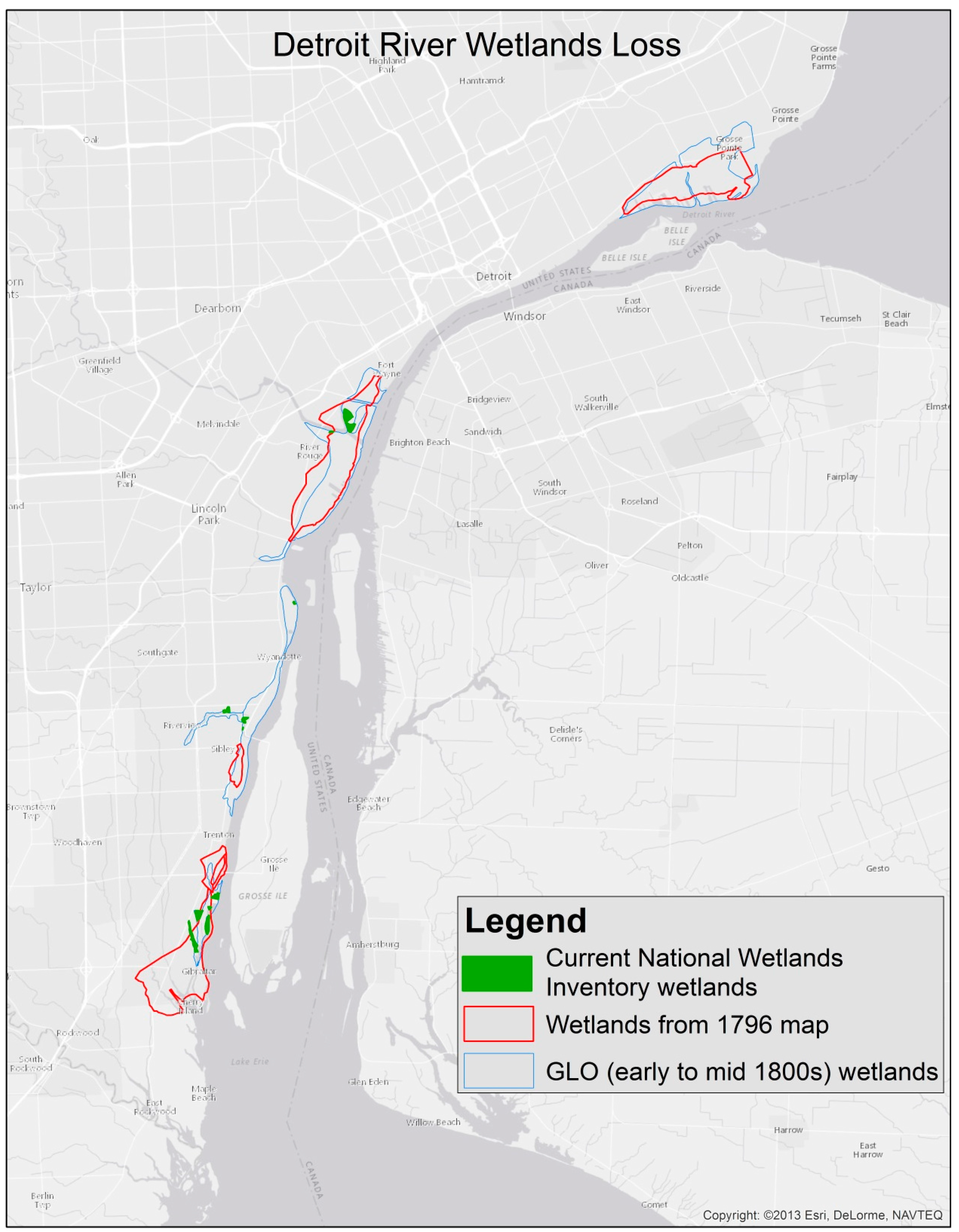
Wetland loss was calculated by comparing digitized wetland extents from a map created in 1796 (Figure 1) and General Land Office (GLO) surveys from circa 1800 to current National Wetland Inventory maps [11,12]. While each of these historic sources has known accuracy issues, they represent the only pre-industrial data available. This limitation is illustrated by the fact the areal extents of mapped wetlands do not completely coincide. However, total area indicated by each source was in close agreement.
2.2. Soft Shoreline Survey Methods
In 2015–2016, a survey of soft shoreline engineering projects along the U.S. mainland shoreline of the Detroit River was performed to document project goals, nature of work, costs, timeframe, partners, and post-project monitoring of effectiveness. For the purposes of this survey, soft shoreline engineering was defined as any project that added some aquatic and riparian shoreline habitat, including:
- incidental habitat (i.e., adding habitat components to a structure like a breakwater), or
- changing from steel sheet piling or concrete breakwater to some limestone rip-rap that provided some limited habitat features.
From a habitat perspective, all three of the categories above are superior to steel sheet piling or concrete breakwater, however, soft shoreline engineering is more beneficial than incidental habitat and rip-rap. It is recognized that negative physicochemical and biological impacts of rip-rap have been documented [9,14], including decreasing habitat complexity and reducing connectivity to terrestrial habitats [15,16]. In Lake St. Clair, rip-rap hardening altered shoreline morphology and invertebrate communities, and impaired terrestrial-aquatic resource exchanges [17]. However, other studies have shown that rip-rap does provide fish habitat with interstitial spaces for cover and food production, and habitats for other organisms [18,19]. Indeed, lake whitefish have been found to spawn on rip-rap in the Detroit River off Fighting Island [20]. Lake sturgeon have been found to spawn off rip-rap in Lake Winnebago in Wisconsin [21]. Therefore, for the purposes of this survey changing from steel sheet piling or concrete breakwater to rip-rap in a consistently high flow river is considered a form of soft shoreline because it provides some habitat features.
Comparable data have not been compiled on Canadian side of the Detroit River and therefore could not be incorporated in this study.
3. Historical Background
As an illustration of anthropogenic impacts on the U.S. portion of the Detroit River shoreline, it is worth reviewing a brief history of Detroit. Native Americans lived along the Detroit River for over a millennium before Europeans came to the region. In 1701, Antoine de la Mothe Cadillac founded Detroit as a French trading post and garrison to expand trade and commerce [22]. To help establish Detroit as a full-service community that was self-supporting, Cadillac began awarding ribbon farms soon after he arrived in 1701. These ribbon farms were long, narrow, land divisions lined up perpendicular to the Detroit River. Figure 1 shows how ribbon farms had been established along much of Detroit’s riverfront by 1796. Such agricultural practices were undoubtedly some of the first European impacts on the Detroit River shoreline and its coastal wetlands, especially filling wetlands.
As Detroit grew into a center of commerce and trade, a number of wharfs were constructed starting in 1760 that projected into the Detroit River. This encroachment of wharfs and docks into the Detroit River continued for many years through the latter 18th century. Such encroachment into the river also led to loss of coastal wetland habitats [23].
In 1805, a devastating fire occurred that destroyed all wooden structures in a single day. Soon after this “Great Fire of 1805” the city was re-platted, projecting lots into the Detroit River. These new platted lots, including a portion of the Detroit River, were now part of the city. Debris from the fire was used to help fill in the coastal wetlands of the Detroit River.
The physical configuration of Detroit’s waterfront continued to change. In 1816, a wharf 3 m wide and extending 61 m into the Detroit River was authorized [24]. In 1818, Walk-In-The-Water, the first steamboat on the upper Great Lakes, arrived in Detroit, which encouraged new settlers—the normal two-week voyage across Lake Erie was cut down to just a few days. Regular cruise schedules were soon established between Buffalo, New York, and Detroit.
Such improved water transportation expanded Detroit’s population. Detroit’s population increased from 900 in 1817 to 2200 in 1830 to 9700 in 1837. Indeed, the Detroit River became so busy with steamboats and sailing vessels that it was declared a “public highway” by U.S. Congress in 1819 [24], furthering the development of the shoreline for commerce and degrading habitats.
In 1827 the Detroit City Council voted to further improve its waterfront facilities with a 18.3-m wide dock at the foot of Woodward Avenue. By September of 1827, this embankment project (as it was called at that time) was completed that provided a convenient safe landing for vessels and improved the “filthiness” associated with the wharfs that was perceived to be causing waterborne diseases [25]. During this project and at the same time that they were demolishing Fort Shelby in Detroit, abandoned earth works from the fort were used to fill in the riverfront, in addition to debris from the “Great Fire of 1805”. In total, this embankment project resulted in human encroachment of an estimated 0.5 km into the river. A combination of timber framing and earth was used to create a new wharf at the expense of the river’s wetland and riparian habitats.
It would not be until the 1890s that the U.S. Army Corps of Engineers would initially establish harbor lines in the Detroit River to regulate where piers and other structures could be built. During this time shoreline filling activities were allowed landward of harbor lines without federal approval or authorization. This policy became official in 1899 with the signing of the Rivers and Harbors Act. Section 10 of this Act prohibited the creation of any obstruction not authorized by Congress to the navigable capacity of any waters of the United States. Further, it stated that it was unlawful to “build or commence the building of any wharf, pier, dolphin, boom, weir, breakwater, bulkhead, jetty, or other structures in any port, roadstead, haven, harbor, canal, navigable river, or other water of the United States, outside established harbor lines”. During the late-1800s, 8 km of Detroit River waterfront were almost continuously lined with docks [24].
It should also be noted that three creeks (i.e., 2-km Savoyard Creek, 4-km May’s Creek, and 5.6-km Bloody Run) in Detroit that emptied into the Detroit River were either filled in or covered over to make way for streets and building sites in Detroit [23,26]. Not only were these streams lost through development, but their floodplains and wetlands were destroyed, eliminating the ecosystem services or life-sustaining benefits they provided to Detroit.
Detroit’s population grew from approximately 45,000 in 1860 to over 285,000 in 1900 [27]. Much of this growth was attributed to the development and growth of manufacturing. For example, in direct response to Detroit’s strategic location in the heart of the Great Lakes, the demand for transportation of passengers and goods, and the availability of essential resources, Detroit became one of the greatest ship-building ports in the United States [28].
Henry Ford built his first car in Detroit 1896, followed by Ransom E. Olds opening Detroit’s first automobile manufacturing plant in 1899. Henry Ford then introduced the assembly line in 1913. In 1904, 3.8% of Detroit’s 60,554 industrial employees were employed in the automobile industry [29]. By 1919, 45% of Detroit’s 308,520 industrial employees were employed in the automobile industry [29]. Detroit was now the “Motor City” and one of the largest industrial manufacturing centers in the world.
By the middle of the 20th century one in six American jobs was connected to the automobile industry and Detroit was its epicenter [30]. It should be no surprise that Detroit reached the apex of its population growth in 1950 with 1.85 million people. During this time the shoreline of the Detroit River was incrementally altered/modified to meet the needs of commerce and industry.
4. Results and Discussion
Based on detailed analyses of the 1796 historical map, GLO survey data, current National Wetlands Inventory data, and recent georeferenced imagery, the U.S. shoreline of the Detroit River has lost approximately 97% of its coastal wetlands to human development (Figure 2). Analysis of the 1796 map produced a total of 1968 ha of coastal wetlands, and the GLO source indicated 2048 ha. Current National Wetlands Inventory data show only 56 ha of connected wetlands remain. In addition, by 1985 55% of the U.S. mainland shoreline had been hardened with steel sheet piling or concrete breakwater, leaving only 45% in a soft shoreline state that provided aquatic and riparian habitat.
Since the 1950s, Detroit experienced considerable loss of population (over a 60% decline since 1950) and industry, rising unemployment, increased cost of living, decreased access to city services, and increased crime. This industrial decline, population emigration, loss of jobs, and concomitant other socio-economic problems culminated in 2013 when Detroit became the largest city in the United States to ever go through bankruptcy. There were now fewer people and industries, and much underutilized and undervalued riverfront land. Citizens had literally lost their connection to the Detroit River.
With the decrease in the Detroit Metropolitan Area’s industrial activity (particularly on the waterfront), the expansion of other modes of transportation (i.e., more goods and people being transported by rail, highway, and air), a growing environmental consciousness (i.e., more people being aware of how they are part of an ecosystem and what they do to their ecosystem they do to themselves), and the growing public interest in close-to-home, outdoor recreation, there has been a unique opportunity and growing interest in reclaiming and redeveloping portions of the waterfront for multiple purposes so that additional benefits can be accrued. Out of this convergence of waterfront redevelopment opportunity and societal-environmental interest, came the concept of soft shoreline engineering [3,13]. Soft shoreline engineering is achieved by using vegetation and other materials to improve the land-water interface by enhancing ecological features without compromising the engineered integrity of the shoreline.
Soft shoreline engineering is similar to living shorelines for managing coastal erosion, enhancing intertidal habitat for fish and aquatic resources, and enhancing the resilience of coastal communities and ecosystems, climate changes, and extreme climate events [31,32,33]. The intent is to restore critical ecosystem functions that have been lost due to shoreline hardening. One important distinction that must be made is that rip-rap, as defined as soft shoreline engineering in this study, does indeed interrupt the natural water/land continuum to the detriment of natural shoreline ecosystems. Living shorelines include any shoreline management system that is designed to protect or restore natural shoreline ecosystems through the use of natural elements and, if appropriate, human-made elements [32]. When used at appropriate sites, living shorelines allow for continued coastal processes and ecosystem connections, while also providing shoreline stabilization and habitat.
Three major barriers to broader use of living shorelines and soft shoreline engineering include: institutional inertia; lack of a broader context for shoreline management decisions; and lack of an effective advocate [32]. Strategies recommended to address these barriers include: education and outreach; regulatory reform, especially in permitting; institutional capacity building; and public agencies becoming role models for use of living shorelines.
In 1999, a group of U.S. and Canadian researchers and natural resource managers convened a conference on soft shoreline engineering and developed a best management practices manual [3] to encourage and catalyze use of soft shoreline engineering techniques. That best management practices manual was then used to educate people on the value and benefits of soft shoreline engineering, and to recruit communities, developers, industries, and others to incorporate it in redevelopment and rehabilitation efforts. Essex Region Conservation Authority later developed another manual to help encourage shoreline property owners in Canada to utilize soft shoreline techniques that provide additional ecological benefits [34].
It was clearly understood that soft shoreline engineering would not be feasible at a port facility that wanted to offload freighters or bring in cruise ships. However, where it was feasible, soft shoreline engineering could help achieve many benefits, including reducing erosion and achieving stability and safety of shorelines, enhancing habitat, improving aesthetics, enhancing urban quality of life, increasing waterfront property values, and even saving money when compared to installing concrete breakwaters or steel sheet piling [3,13].
For the purposes of this study, habitat modification means any efforts to conserve, restore, enhance, mitigate, or rehabilitate habitats. This includes soft shoreline engineering projects, incidental habitat projects (i.e., adding habitat features to existing or planned navigational structures like harbor or marina walls, breakwaters, and piers [35]), and steel sheet piling or concrete breakwater replacement projects that utilize limestone rip-rap that provides some habitat features. It is acknowledged that rip-rap is not ideal from a habitat perspective, however, it is better than steel sheet piling and concrete breakwater because it does provide some habitat for fish and other organisms [18,19,20,21].
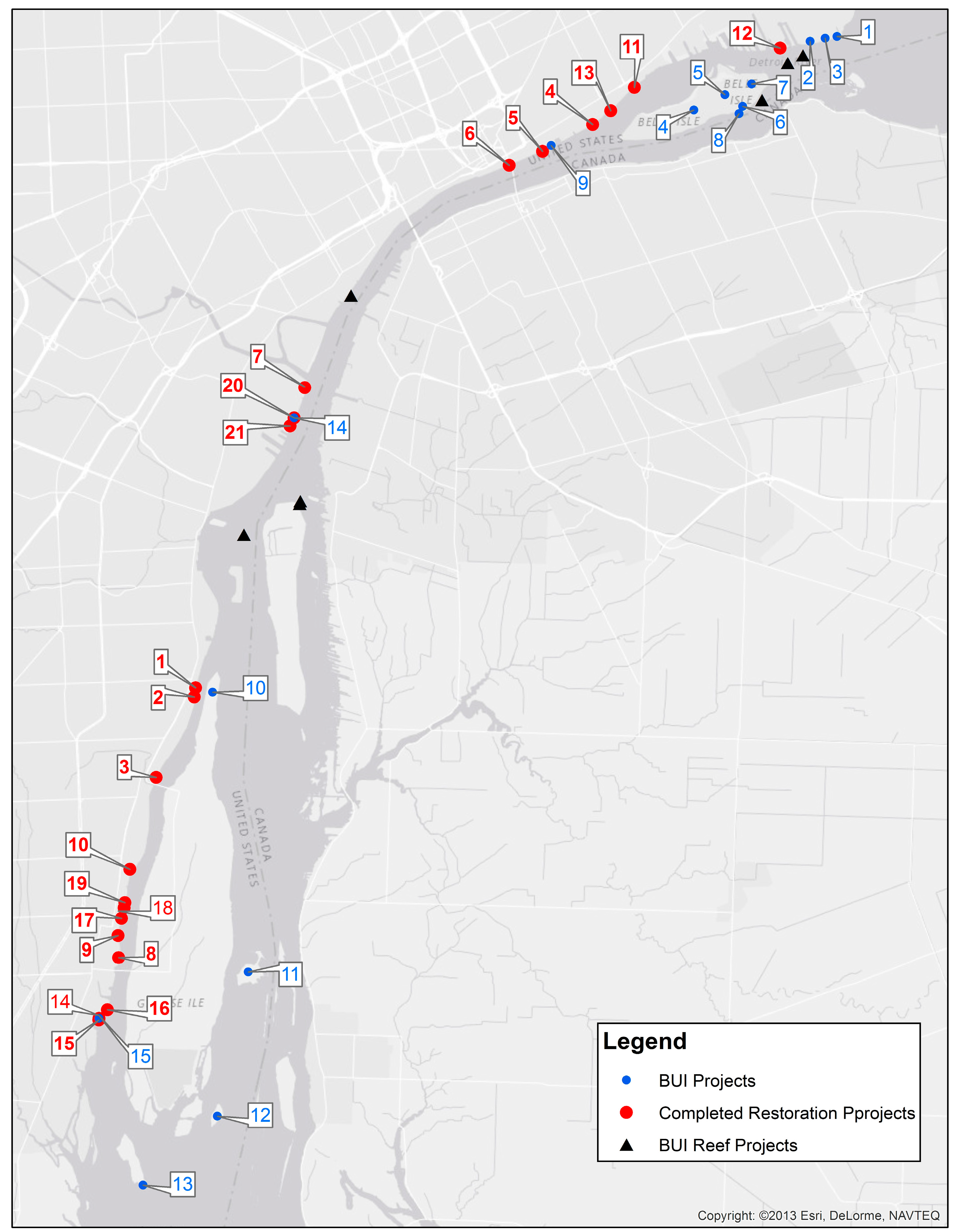
Between 1995 and 2016, 19 different shoreline habitat modification projects were completed, representing soft shoreline engineering, incidental habitat, or changing from steel sheet piling or concrete breakwater to some limestone rip-rap that provided some limited habitat features (Table 2; Figure 3). Of these 19 projects, eight were soft shoreline engineering, seven involved converting shorelines to limestone rip-rap to add habitat components, and four provided incidental habitat to structures. Figure 4 provides before and after photographs of two of the soft shoreline engineering projects surveyed in this study.
Based on a review of all soft shoreline-engineering projects in the watershed [36] and this survey, it was important to involve scientists and resource managers during the initial project planning to broaden the scope of shoreline restoration to include ecological goals. All projects were undertaken as demonstration projects to help showcase benefits and encourage other projects. Broadening project partners also helped bring in new funders that leveraged existing funding.
Of the 19 shoreline habitat projects implemented since 1995, 11 had no post-project monitoring, seven had qualitative monitoring, and only one had any quantitative post-project monitoring (Table 2). This problem of limited post-project monitoring could be rectified by: incorporating pre- and post-project monitoring of effectiveness into all federal and state permits for habitat modification; ensuring that any shoreline restoration grants include post-project monitoring; or working with conservation partners to sign a Memorandum of Understanding or a non-binding partnership agreement to perform pre- and post-project monitoring to measure project effectiveness [36].
In total, these 19 projects identified in Table 2 improved 4.93 km of shoreline from a habitat perspective since 1995. The Lake Erie Biodiversity Conservation Strategy is a binational initiative designed to support the efforts of the Lake Erie Lakewide Management Plan by identifying specific strategies and actions to protect and conserve the native biodiversity of Lake Erie [37]. The scope of Lake Erie Biodiversity Conservation Strategy includes the lake itself, the Connecting Channels, including the Detroit River, and the adjacent watersheds to the extent that they affect the biodiversity of the lake. This Strategy developed science-based targets based on a review of existing Great Lakes conservation strategies, scientific assessments of Lake Erie, and input from the project core team, conservation organizations, and other stakeholders. For the Detroit River, the following soft shoreline targets were recommended to provide critical habitats for the full diversity of native species [37]:
- less than 60% soft shoreline—poor quality;
- 60–70% soft shoreline—fair quality;
- 70–80% soft shoreline—good quality; and
- greater than 80% soft shoreline—very good quality.
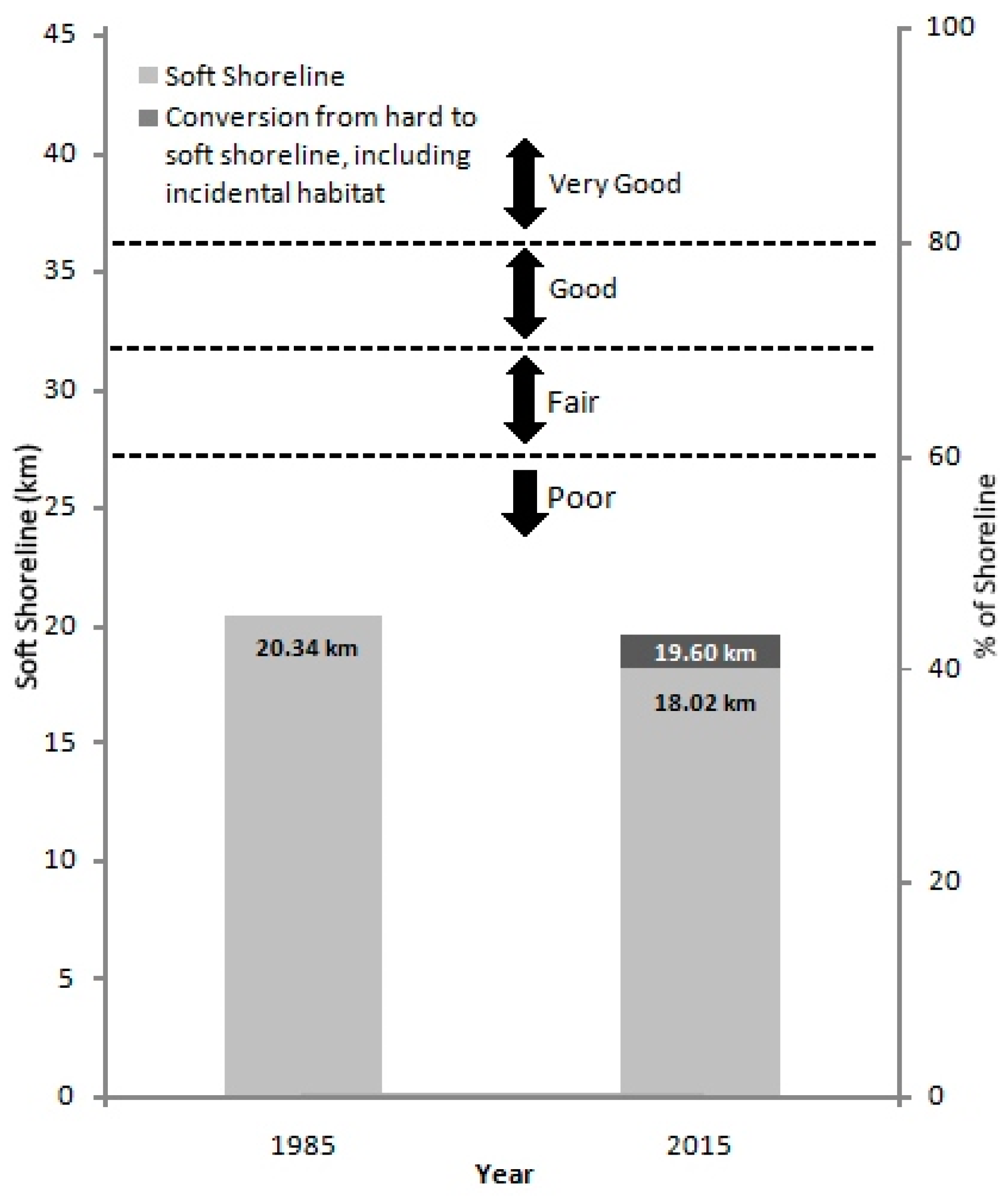
A comparison of the 1985 and 2015 georeferenced aerial imagery showed that 2.32 km of soft shoreline was converted to hard shoreline (Figure 5). Of the 19 projects surveyed in Table 2, 11 projects representing 3.35 km made habitat improvements to Detroit River shoreline that was already georeferenced as “soft“, three projects representing 360 m of shoreline were converted from “hard’ to “soft”, and five projects representing 1.22 km added incidental habitat to a hardened shoreline. It is interesting to note that one of the projects that converted from “soft” to “hard” shoreline was the BASF Riverview project that installed steel sheet piling to maintain an inward hydraulic gradient to prevent input of contaminants to the river from a brownfield site. As part of this brownfield cleanup BASF also added 366 m of incidental habitat at the base of the sheet pile wall, along with 0.4 ha of walleye, largemouth bass, and sturgeon spawning habitat in the river. Habitat experts advocated for this as part of the remedial design.
Figure 5 shows that even with the addition of 1.58 km of new soft shoreline and incidental habitat, there was an overall net loss of 0.74 km of soft shoreline over the 30-year timeframe. This confirms that shoreline hardening continues despite the best efforts of resource managers and conservation organizations. The reasons for this include lack of proper training among planners and designers, lack of “habitat champions” at design phase of urban waterfront redevelopment projects, and the perceived risks associated with alternatives to hard engineering. This also points out a need for continuous and vigorous oversight of shoreline development projects to ensure long-term shoreline habitat goals can be met. To reach the “good” state of at least 70% soft shoreline, an additional 12.1 km of soft shoreline would have to be added in the future.
Most of these shoreline habitat projects in Table 2 were undertaken opportunistically through a variety of management tools to enhance/improve riparian or aquatic habitat, including: erosion protection; nonpoint source pollution control; Supplemental Environmental Projects (i.e., a regulatory tool that implements an environmental improvement project instead of paying fines and penalties to a general fund); contaminated sediment remediation; improvement of waterfront parks; enhancement of private developments; and greenway trail projects. However, there is also a need to move beyond opportunistic habitat rehabilitation and enhancement, and achieve scientifically defensible, ecosystem-based management. This will require greater identification, quantification, and understanding of essential habitats as a prerequisite to successful management of target species and assemblages. Lack of scientific understanding and institutional problems have been identified as major impediments to scientifically defensible management of coastal habitats [38]. Clearly, it has been an enormous management challenge to shift from managing species/assemblages to managing habitats to support species/assemblages, particularly in an environment of limited resources for research and management infrastructure [38].
Actions to rehabilitate and enhance degraded habitats should be based on the understanding of causes and predicted results [38]. Adequate assessment, research, and monitoring are essential to define problems, establish cause-and-effect relationships, evaluate habitat rehabilitation and enhancement options, select preferred rehabilitation and enhancement techniques, and document effectiveness. It has been recommended that resource management agencies, with stakeholder input, should identify desired species, then quantify the amount and quality of habitats required to produce and sustain each species by life history stage [39]. Once this collective knowledge is obtained, quantitative habitat targets can be established, habitat management options reviewed, and the preferred actions selected. After implementation of the preferred actions, it is recommended that monitoring be performed for at least five years to ensure that the quantitative habitat targets are met and that the restored habitats remain protected and productive [39]. Such monitoring would also allow for implementing additional habitat management actions consistent with adaptive management that calls for assessing status, setting priorities, and taking actions in an iterative fashion for continuous improvement. It is recognized that much longer-term monitoring will be required to reach and document a new equilibrium.
For over 30 years the Michigan Department of Environmental Quality and the Public Advisory Committee for the Detroit River Area of Concern (i.e., a pollution hotspot in the Great Lakes where there is impairment of beneficial uses) have been working to restore impaired beneficial uses in the Detroit River Area of Concern as part of the U.S.-Canada Great Lakes Water Quality Agreement [40]. To guide restoration efforts, the Detroit River Public Advisory Committee has identified 14 projects that, when completed, would constitute removal of “loss of fish and wildlife habitat” as an impaired beneficial use (Table 3; Figure 3).
Completing these Detroit River Area of Concern projects and achieving these administrative/management targets will clearly have a positive impact on habitat of the Detroit River. However, it will also be important to track progress and eventually achieve ecosystem-based targets like the percentage and length of soft shoreline presented above. Such ecosystem-based targets will help measure ecological progress and are consistent with the U.S.-Canada Great Lakes Water Quality Agreement. Indeed, researchers have argued for inserting evidence-based management into conservation practice, including quantitative outcome-based monitoring toward clear measurable objectives [42].
5. Concluding Remarks and Outlook
As a result of the 97% loss of coastal wetlands along the U.S. mainland of the Detroit River (due to urban and industrial development) and the hardening of 55% of the U.S. mainland shoreline with steel sheet piling or concrete breakwater by 1985, partnerships were formed to rehabilitate shoreline habitat to restore fish and wildlife populations, and to achieve benefits from the additional ecosystem services this habitat would provide. Similarly, there has been a 95% loss of coastal wetlands on the Canadian mainland of the river and 80% of the Canadian shoreline has been developed as a result of urbanization, with the majority of the shoreline being artificially hardened [43].
Since 1995, 19 projects were implemented improving 4.93 km of shoreline habitat. A comparison of the 1985 and 2015 georeferenced aerial imagery showed that 2.32 km of soft shoreline was converted to hard shoreline during this timeframe. Of the 19 projects surveyed, 11 projects representing 3.35 km made habitat improvements to shoreline that was already georeferenced as “soft“, three projects representing 360 m of shoreline were converted from “hard’ to “soft,” and five projects representing 1.22 km added incidental habitat to hardened shoreline. Even with the addition of 1.58 km of new soft shoreline and incidental habitat, there was an overall net loss of 0.74 km of soft shoreline over the 30-year timeframe. To reach the “good” state of at least 70% soft shoreline, an additional 12.1 km of soft shoreline will have to be added in the future. This confirms that shoreline hardening continues despite the best efforts of resource managers and conservation organizations, and that there must be continuous and vigorous oversight of shoreline development projects to ensure long-term shoreline habitat goals can be met.
Restoring shoreline habitat along the Detroit River will clearly be a long-term process, with incremental progress. As urban waterfront redevelopment progresses, it will be important to be opportunistic and involve habitat experts up front in the design phase because experience in metropolitan Detroit has shown that it is at the design stage where key decisions get made. At the outset of new urban waterfront development projects it will also be important to establish broad-based objectives for shoreline engineering with quantitative targets for project success, and to ensure sound multidisciplinary technical support throughout the project.
Urban river shoreline restoration will undoubtedly progress following adaptive management. For management organizations interested in restoring shorelines of urban rivers it is recommended to:
- start with demonstration projects and attract many partners to leverage resources;
- treat habitat modification projects as experiments that promote learning, where hypotheses are developed and tested using scientific rigor;
- involve citizen scientists, volunteers, university students, and/or researchers in monitoring, and obtain commitments for post-project monitoring of effectiveness up front in project planning;
- measure benefits and communicate successes; and
- promote education and outreach, including public events that showcase results and communicate benefits [36].
Much like the sustainable development efforts to recreate front porches on city houses to encourage a sense of community, soft-engineered shorelines along urban waterfronts can help recreate gathering places for both wildlife and people.
Acknowledgments
This manuscript would not be possible without the leadership of the many soft shoreline engineering partners who catalyzed and completed the 19 projects discussed in this manuscript. We gratefully acknowledge their important work that laid the foundation for this manuscript.
Author Contributions
Hartig J. and Bennion D. conceived and performed the GIS analyses and the soft shoreline survey, and wrote this paper.
Conflicts of Interest
The findings and conclusions in this article are those of the author(s) and do not necessarily represent the views of the U.S. Fish and Wildlife Service.
References
- Bolsenga, S.J.; Herdendorf, C.E. Lake Erie and Lake St. Clair Handbook; Wayne State University Press: Detroit, MI, USA, 1993. [Google Scholar]
- Hartig, J.H. Bringing Conservation to Cities: Lessons from Building the Detroit River International Wildlife Refuge; Aquatic Ecosystem Health and Management Society: Burlington, ON, Canada, 2014. [Google Scholar]
- Caulk, A.D.; Gannon, J.E.; Shaw, J.R.; Hartig, J.H. Best Management Practices for Soft Engineering of Shorelines; Greater Detroit American Heritage River Initiative: Detroit, MI, USA, 2000. [Google Scholar]
- Seitz, R.; Lipcius, R.; Olmstead, N.; Seebo, M.; Lambert, D. Influence of shallow-water habitats and shoreline development on abundance, biomass, and diversity of benthic prey and predators in Chesapeake Bay. Mar. Ecol. Prog. Ser. 2006, 326, 11–27. [Google Scholar] [CrossRef]
- Bilkovic, D.M.; Roggero, M.M. Effects of coastal development on nearshore estuarine nekton communities. Mar. Ecol. Prog. Ser. 2008, 358, 27–39. [Google Scholar] [CrossRef]
- Dugan, J.E.; Hubbard, D.M.; Rodil, I.F.; Revell, D.L.; Schroeter, S. Ecological effects of coastal armoring on sandy beaches. Mar. Ecol. 2008, 29, 160–170. [Google Scholar] [CrossRef]
- Lucrezi, S.; Schlacher, T.A.; Robinson, W. Can storms and shore armouring exert additive effectson sandy-beach habitats and biota. Mar. Freshw. Res. 2010, 61, 951–962. [Google Scholar] [CrossRef]
- Gittman, R.K.; Peterson, C.H.; Currin, C.A.; Joel Fodrie, F.; Piehler, M.F.; Bruno, John F. Living shorelines can enhance the nursery role of threatened estuarine habitats. Ecol. Appl. 2016, 26, 249–263. [Google Scholar] [CrossRef] [PubMed]
- Patrick, C.J.; Weller, D.E.; Ryder, M. The Relationship between Shoreline Armoring and Adjacent Submerged Aquatic Vegetation in Chesapeake Bay and Nearby Atlantic Coastal Bays. Estuaries Coasts 2016, 39, 158–170. [Google Scholar] [CrossRef]
- Schneider, J.; Heaton, D.; Leadlay, H. Extent of hardened shoreline. State of the Lakes Ecosystem Conference, U.S. Environmental Protection Agency, Chicago, Illinois and Environment Canada, Toronto, Ontario, Canada. 2009. Available online: https://binational.net//wp-content/uploads/2014/11/En161-3-1-2009E.pdf (accessed on 15 May 2017).
- Bourdo, E.A. A Review of the General Land Office Survey and of Its Use in Quantitative Studies of Former Forests. Ecology 1956, 37, 754–768. [Google Scholar] [CrossRef]
- King, F.B. Additional Cautions on the Use of the Glo Survey Records in Vegetational Reconstructions in the Midwest. Am. Antiq. 1978, 43, 99–103. [Google Scholar] [CrossRef]
- Hartig, J.H.; Kerr, J.K.; Breederland, M. Promoting soft engineering along Detroit River shorelines. Mag. Nat. Resour. Manag. Restor. 2001, 45, 24–27. [Google Scholar]
- Gabriel, A.O.; Bodensteiner, L.R. Impacts of Riprap on Wetland Shorelines, Upper Winnebago Pool Lakes, Wisconsin. Wetlands 2012, 32, 105–117. [Google Scholar] [CrossRef]
- Peterson, M.S.; Comyns, B.H.; Hendon, J.R.; Bond, P.J.; Duff, G.A. Habitat use by early life-history stages of fishes and crustaceans along a changing estuarine landscape: differences between natural and altered shoreline sites. Wetl. Ecol. Manag. 2000, 8, 209–219. [Google Scholar] [CrossRef]
- Romanuk, T.N.; Levings, C.D. Associations between Arthropods and the Supralittoral Ecotone: Dependence of Aquatic and Terrestrial Taxa on Riparian Vegetation. Environ. Entomol. 2003, 32, 1343–1353. [Google Scholar] [CrossRef]
- Wensink, S.M.; Tiegs, S.D. Shoreline hardening alters freshwater shoreline ecosystems. Freshw. Sci. 2016, 35, 764–777. [Google Scholar] [CrossRef]
- Jennings, M.J.; Bozek, M.A.; Hatzenbeler, G.R.; Emmons, E.E.; Staggs, M.D. Cumulative Effects of Incremental Shoreline Habitat Modification on Fish Assemblages in North Temperate Lakes. N. Am. J. Fish. Manag. 1999, 19, 18–27. [Google Scholar] [CrossRef]
- Pister, B. Urban marine ecology in southern California: The ability of riprap structures to serve as rocky intertidal habitat. Mar. Biol. 2009, 156, 861–873. [Google Scholar] [CrossRef]
- Roseman, E.F.; Kennedy, G.W.; Boase, J.; Manny, B.A.; Todd, T.N.; Stott, W. Evidence of Lake Whitefish Spawning in the Detroit River: Implications for Habitat and Population Recovery. J. Gt. Lakes Res. 2007, 33, 397–406. [Google Scholar] [CrossRef]
- Folz, D.J.; Meyers, L.S. Management of lake sturgeon, Ascipenser fluvescens, population in Lake Winnebago system, Wisconsin. In North American Sturgeons: Biology and Aquaculture Potential; Binkowski, F.P., Doroshov, S.I., Eds.; Springer: Dordrecht, The Netherlands, 1985; pp. 136–146. [Google Scholar]
- Binelli, M. Detroit City Is the Place to Be: An Afterlife of an American Metropolis; Henry Holt and Company: New York, NY, USA, 2012. [Google Scholar]
- Farmer, S. History of Detroit and Wayne County and Early Michigan: A Chronological Cyclopedia of the Past and Present; Silas Farmer and Company: Detroit, MI, USA, 1890. [Google Scholar]
- Levanen, A.J. The River’s Edge: A History of the Detroit Waterfront. Telescope 2000, XLVIII, 6–9. [Google Scholar]
- Dunnigan, B.L. Frontier Metropolis: Picturing Early Detroit, 1701–1838; Wayne State University Press: Detroit, MI, USA, 2001. [Google Scholar]
- Hudgins, B. Old Detroit: Drainage and Land Forms. Mich. Hist. Mag. 1946, 30, 348–368. [Google Scholar]
- Dunbar, W.F. Michigan: A History of the Wolverine State; W.B. Eerdmans Publishing Company: Grand Rapids, MI, USA, 1965. [Google Scholar]
- Hartig, J.H. Honoring Our Detroit River: Caring for Our Home; Cranbrook Institute of Science: Bloomfield Hills, MI, USA, 2003. [Google Scholar]
- Holli, M.G. (Ed.) Detroit; New Viewpoints, a Division of Franklin Watts: New York, NY, USA, 1976. [Google Scholar]
- Martelle, S. Detroit: A Biography; Chicago Review Press: Chicago, IL, USA, 2012. [Google Scholar]
- National Oceanic and Atmospheric Administration. Guidance for Considering the Use of Living Shoreline. 2015. Available online: http://www.habitat.noaa.gov/pdf/noaa_guidance_for_considering_the_use_of_living_shorelines_2015.pdf (accessed on 10 May 2017).
- Restore America’s Estuaries. Living Shorelines: From Barriers to Opportunities. 2015. Available online: https://www.estuaries.org/images/stories/RAEReports/RAE_LS_Barriers_report_final.pdf (accessed on 10 May 2017).
- Chesapeake Bay Foundation. Living Shorelines for the Chesapeake Bay Watershed; Chesapeake Bay Foundation: Annapolis, MD, USA, 2007. [Google Scholar]
- Essex Region Conservation Authority. Detroit River Canadian Shoreline Restoration Alternatives Selection Manual. 2014. Available online: http://erca.org/wp-content/uploads/2013/01/Detroit-River-Shoreline-Manual24Oct2014.pdf (accessed on 10 May 2017).
- Nguyen, N.; Tun, L.; Chan, L. If You Build It, They Will Come: Modifying Coastal Structures for Habitat Enhancement. 2016. Available online: http://www.thenatureofcities.com/2016/10/05/if-you-build-it-they-will-come-modifying-coastal-structures-for-habitat-enhancement/ (accessed on 14 November 2016).
- Hartig, J.H.; Zarull, M.A.; Cook, A. Soft shoreline engineering survey of ecological effectiveness. Ecol. Eng. 2011, 37, 1231–1238. [Google Scholar] [CrossRef]
- Pearsall, D.; de Grammont, P.C.; Cavalieri, C.; Chu, C.; Doran, P.; Elbing, L.; Ewert, D.; Hall, K.; Herbert, M.; Khoury, M.; et al. Returning to a Healthy Lake: Lake Erie Biodiversity Conservation Strategy. 2012. Available online: https://www.conservationgateway.org/ConservationByGeography/NorthAmerica/UnitedStates/michigan/Documents/LEBCS%20Report.pdf (accessed on 10 May 2017).
- Baird, R.C. Toward new paradigms in coastal resource management: Linkages and institutional effectiveness. Estuaries 1996, 19, 320–335. [Google Scholar] [CrossRef]
- Manny, B.A. Setting priorities for conserving and rehabilitating Detroit River habitats. In Honoring Our Detroit River: Caring for Our Home; Hartig, J.H., Ed.; Cranbrook Institute of Science: Bloomfield Hills, MI, USA, 2003; pp. 79–90. [Google Scholar]
- Canada Ontario Agreement Respecting Great Lakes Water Quality and Michigan Department of Natural Resources. Detroit River Remedial Action Plan: Stage 1; 1991. Available online: https://www.epa.gov/sites/production/files/2013-12/documents/1991_detroitriverrapstg1.pdf (accessed on 10 May 2017).
- Detroit River Public Advisory Committee. Targets for Removal of “Loss of Fish and Wildlife Habitat” and “Degradation of Fish and Wildlife Populations” Beneficial Use Impairments of the Detroit River Area of Concern; Michigan Department of Environmental Quality: Taylor, MI, USA, 2014. [Google Scholar]
- Legge, S. A plea for inserting evidence-based management into conservation practice. Anim. Conserv. 2015, 18, 113–116. [Google Scholar] [CrossRef]
- Essex Region Conservation Authority. Detroit River Shoreline Assessment Report; ERCA: Essex, ON, Canada, 2012. [Google Scholar]
- Bence, S. Army Corps Collaborates with UWM to Create Breakwater Habitat in Milwaukee. 2016. Available online: http://wuwm.com/post/army-corps-collaborates-uwm-create-breakwater-habitat-milwaukee#stream/0 (accessed on 3 April 2017).
Figure 1.
Historical map of the Detroit River shoreline showing wetlands and early ribbon farms, 1796 (map credit: National Oceanic and Atmospheric Administration’s Office of Coast Survey).
Figure 1.
Historical map of the Detroit River shoreline showing wetlands and early ribbon farms, 1796 (map credit: National Oceanic and Atmospheric Administration’s Office of Coast Survey).
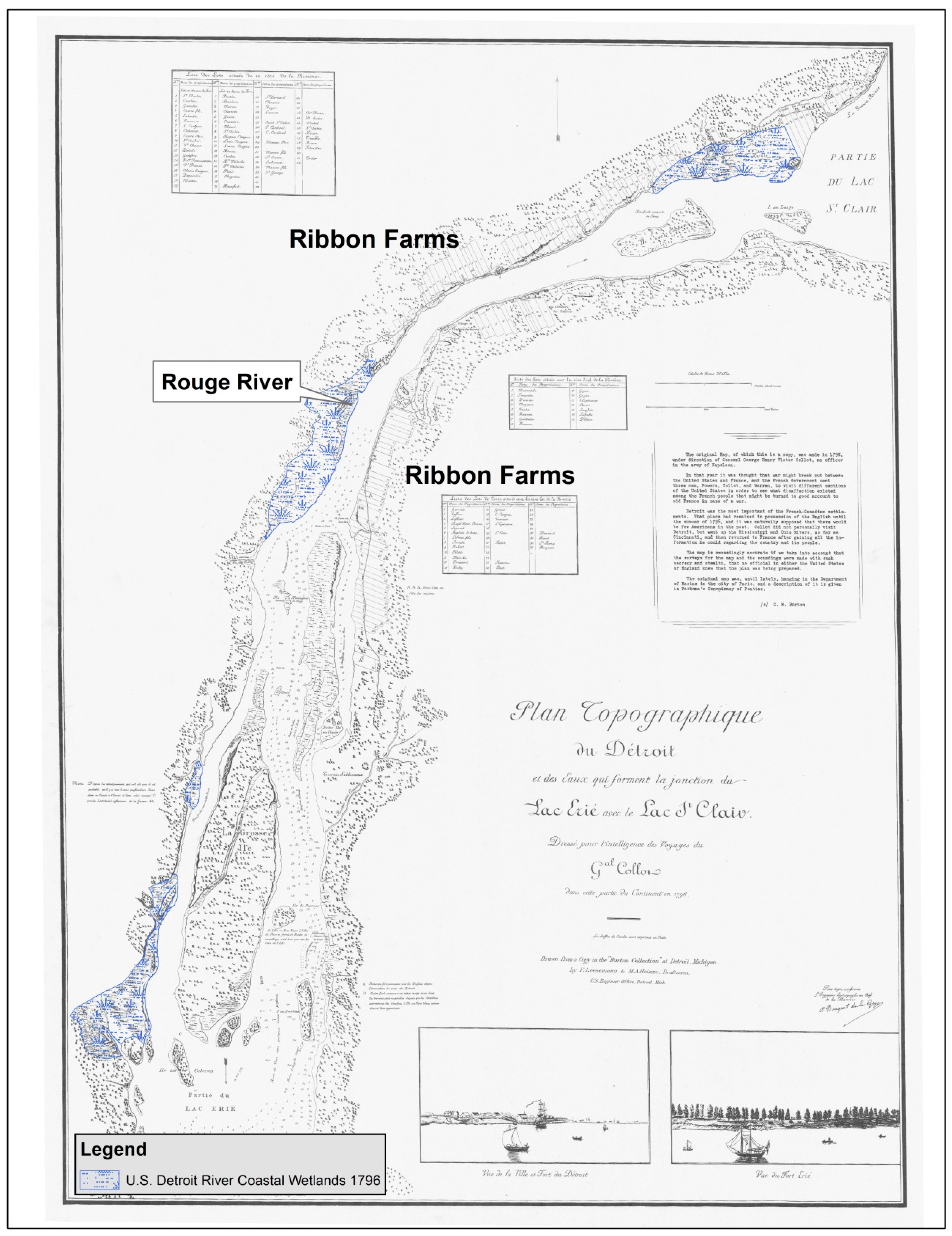
Figure 2.
Extent of wetlands loss along the U.S. mainland of the Detroit River (base map credit: map created using ArcGIS® software by Esri (ArcMap 10.4.1)).
Figure 2.
Extent of wetlands loss along the U.S. mainland of the Detroit River (base map credit: map created using ArcGIS® software by Esri (ArcMap 10.4.1)).

Figure 3.
Detroit River map showing locations of soft shoreline engineering projects and 14 Area of Concern projects that, when completed, would constitute removal of “loss of fish and wildlife habitat” as an impaired beneficial use.
Figure 3.
Detroit River map showing locations of soft shoreline engineering projects and 14 Area of Concern projects that, when completed, would constitute removal of “loss of fish and wildlife habitat” as an impaired beneficial use.

Figure 4.
Photographs of soft shoreline engineering projects at Rouge Power Plant in River Rouge, Michigan ((a): before and (b): after) and Wayne County’s Elizabeth Park in Trenton, Michigan ((c): before and (d): after) (photo credits: Rouge Power Plant shoreline: Nativescape, LLC (Manchester, Michigan, USA); Elizabeth Park: U.S. Fish and Wildlife Service (Grosse Ile, Michigan, USA)).
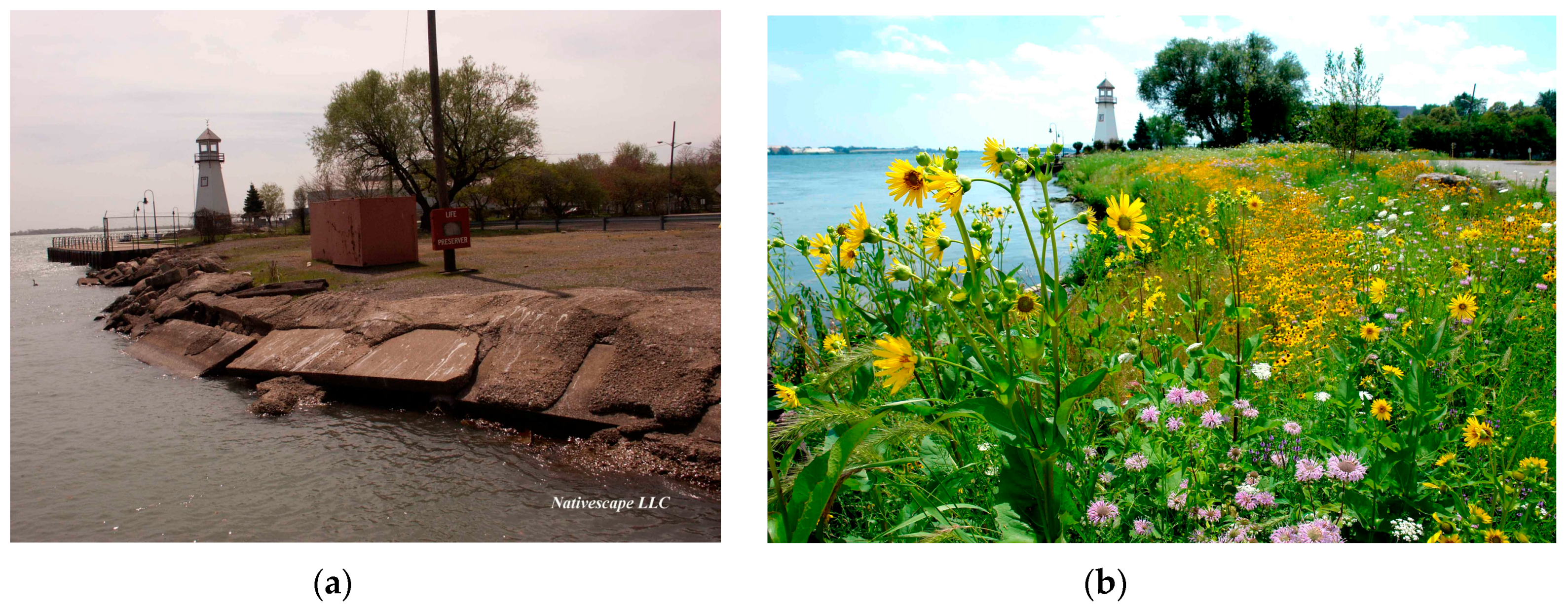
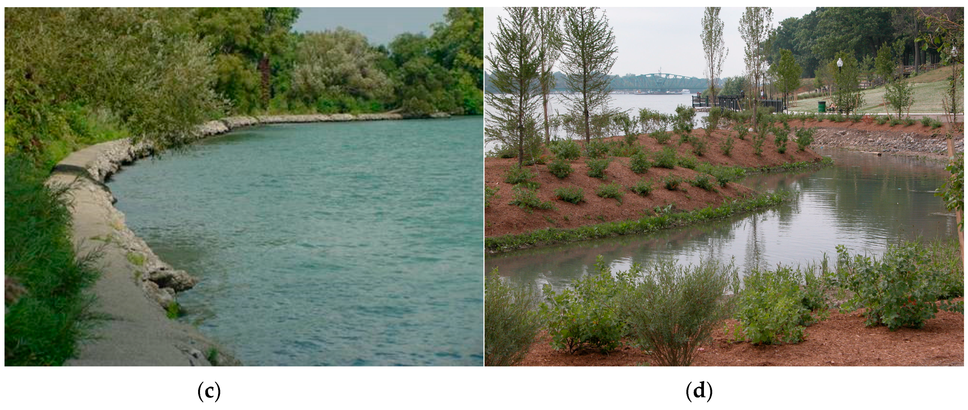
Figure 5.
A comparison of the extent of soft shoreline along the U.S. mainland of the Detroit River as measured by georeferenced aerial imagery, 1985 and 2015.
Figure 5.
A comparison of the extent of soft shoreline along the U.S. mainland of the Detroit River as measured by georeferenced aerial imagery, 1985 and 2015.

Table 1.
Examples of exceptional natural resource attributes of the Detroit River [2].
Table 1.
Examples of exceptional natural resource attributes of the Detroit River [2].
| Natural Resource Attribute | Description |
|---|---|
| Birds |
|
| Fish |
|
| Biodiversity and International Designations |
|
Table 2.
A survey of soft shoreline engineering projects implemented along the U.S. mainland shoreline of the Detroit River, 1995–2016.
Table 2.
A survey of soft shoreline engineering projects implemented along the U.S. mainland shoreline of the Detroit River, 1995–2016.
| Location | Figure 3 Locator | Project Type | Project Goals | Project Description and Cost | Timeframe | Partners | Monitoring |
|---|---|---|---|---|---|---|---|
| BASF Waterfront Park, Wyandotte, Michigan | 1 ● | Rip-rap | Transform a former shipbuilding and chemical manufacturing site (40 ha) along the Detroit River into a public recreation area (called BASF Waterfront Park) and a nine-hole golf course | As part of a $9.1 million park redevelopment and brownfield cleanup, 390 m of shoreline were stabilized and enhanced using limestone rip-rap | Consent Decree signed in 1985; golf course and park opened in 1995 | City of Wyandotte, BASF Corp., Michigan Department of Environmental Quality | None |
| BASF Park, Wyandotte, Michigan | 2 ● | Small rip-rap | Demonstrate use of Elastocoast (Elastomeric revetment that stabilizes shorelines and enhances habitat by increasing interstitial spaces) along the Detroit River shoreline of BASF Park | Stabilized nine meters of Detroit River shoreline to a depth of 37 cm with five-cm crushed limestone bound together with the Elastocoast product; $6000 | 2008 | BASF Corporation, City of Wyandotte | Qualitative |
| BASF Riverview, Trenton Channel, Riverview, Michigan | 3 ● | Incidental habitat | Remediate a contaminated site, add incidental habitat to steel sheet piling walls, and create one acre of fish spawning habitat | Following remediation of a brownfield site, incidental habitat was added to 366 m of steel sheet piling, and 0.4-ha of walleye, smallmouth and largemouth bass, and sturgeon spawning habitat was created; $100,000 | 2007–2008 | BASF Corporation, Michigan Department of Environmental Quality | None |
| Detroit RiverWalk-Stroh River Place, Detroit, Michigan | 4 ● | Incidental habitat | Build a section of the Detroit RiverWalk in front of Stroh River Place and enhance riparian habitat | Built a 305-m section of the Detroit RiverWalk using a cantilever design with habitat features beneath the cantilevered RiverWalk; $1 million | 2006–2007 | Detroit Riverfront Conservancy, Stroh Companies, Inc., Omni Hotel, and Tallon Industries | None |
| Detroit RiverWalk-West of Milliken State Park, Detroit, Michigan | 5 ● | Rip-rap | Stabilize the shoreline along the Detroit RiverWalk and enhance aquatic habitat | Stabilized 152 m of shoreline with varying sizes of rock armor stone and enhanced aquatic habitat; $100,000 | 2003–2004 | Detroit Riverfront Conservancy and General Motors Corporation | None |
| Detroit-Wayne County Port Authority, Detroit, Michigan | 6 ● | Incidental habitat | Enhance fish spawning habitat in conjunction with construction of a 61-m wharf to support Port Authority operations | Enhanced fish spawning habitat through placement of 512 m3 of limestone rip-rap covering 832 m2 (64 m by 13 m) at the base of the wharf | 2007 | Detroit/Wayne County Port Authority, Detroit Riverfront Conservancy | None |
| DTE’s Rouge Power Plant, River Rouge, Michigan | 7 ● | Soft shoreline | Remove broken concrete and asphalt, stabilize shoreline, and enhance habitat | Reconstructed 61 m of natural shoreline using soft engineering techniques and reestablished a natural riparian buffer made up of four Michigan native plant communities; $30,000 | 2005 | DTE Energy, Nativescape, U.S. Fish and Wildlife Service, Department of Environmental Quality, and six other partners | Qualitative |
| Elizabeth Park—Phase 2, South River Walk, Trenton, Michigan | 8 ● | Soft shoreline | Stabilize and enhance 183 m of shoreline, recreate river walk, and enhance underwater fish habitat | Removed a 1910 concrete breakwall from the north end of Elizabeth Park, stabilized the shoreline using soft engineering techniques, and created two oxbow islands for nursery habitat for fish; $925,000 | 2005 | Clean Michigan Initiative and Wayne County Parks | Quantitative |
| Elizabeth Park—Phase 3, North River Walk, Trenton, Michigan | 9 ● | Rip-rap | Stabilize 250 m of Detroit River shoreline, complete the River Walk, and enhance riparian habitat | Graded back the shoreline and stabilized it with Armor stone and landscape plantings, and completed River Walk; $400,000 | 2012 | Michigan Natural Resources Trust Fund and Wayne County Parks | None |
| Ellias Cove, Trenton, Michigan | 10 ● | Soft shoreline | Remediate mercury, lead, zinc, and PCB contaminated sediment from Ellias Cove and restore the shoreline using soft engineering techniques | Removed 88,000 m3 of sediment and disposed contaminated sediment in special contaminant cell at Pointe Mouillee Confined Disposal Facility in western Lake Erie and restored 270 m of shoreline habitat, including nursery habitat for fish; $150,000 for habitat portion | 2006 | U.S. Environmental Protection Agency, Michigan Department of Environmental Quality, Great Lakes Basin Program for Soil Erosion and Sediment Control, and seven other partners | Qualitative |
| Gabriel Richard Park, Detroit, Michigan | 11 ● | Rip-rap | Stabilize river shoreline, restore fish habitat, and provide aesthetically-pleasing environment | Stabilized and restored 300 m of shoreline with fish habitat components, including the addition of two fishing overlooks; $300,000 | 2006–2007 | Detroit Riverfront Conservancy, Detroit Parks and Recreation, and JJR | None |
| Maheras Gentry Park, Detroit, Michigan | 12 ● | Soft shoreline | Create an oxbow and restore fish and wetland habitat as mitigation for the construction of Conner Creek Combined Sewer Overflow Control Facility | Removed 38,300 m3 of soil to create an oxbow, restored 508 m of shoreline habitat, planted native aquatic plants to improve fish habitat, and created fish spawning and nursery areas; $2.3 million | 2000–2004 | Detroit Water and Sewerage Department and Detroit Parks and Recreation | Qualitative |
| Mt. Elliott Park, Detroit, Michigan | 13 ● | Rip-rap | Restore shoreline using limestone of varying sizes and native plant materials in an effort to help restore fish and wildlife habitat | Restored 200 m of shoreline, including providing an interactive water feature and playscape for children that will teach the importance of water; $200,000 for shoreline habitat work | 2012–2013 | Detroit Riverfront Conservancy and Detroit Recreation Department | None |
| Refuge Gateway Shoreline along the Trenton Channel of the Detroit River, Trenton, Michigan | 14 ● | Soft shoreline | Stabilize shoreline using soft engineering techniques and restore coastal wetland and upland buffer habitats | Stabilized 365 m of shoreline using soft shoreline engineering techniques and restored 4.2 ha of emergent marsh, 1.7 ha of submergent marsh, and 4.8 ha of upland buffer habitats; $746,000 | 2010 | Wayne County, Michigan Department of Natural Resources, U.S. Fish and Wildlife Service, and six other partners | Qualitative |
| Refuge Gateway, School Ship Dock and Fishing Pier, Trenton, Michigan | 15 ● | Incidental habitat | Enhance fish spawning habitat in conjunction with construction of a 61-m fishing pier | Nearly 418 m2 of 15–25 cm diameter limestone was placed along a 69 m long × 4.6 m wide fishing pier at a depth of 3–4.6 m to provide spawning habitat and refuge for fish and other aquatic species. Benefiting will be speleophilic (cave spawners) and lithophilic (rock spawners) fish species such as the northern madtom (endangered in State of Michigan and Province of Ontario), lake sturgeon, rock bass, smallmouth bass, and walleye. $100,000 | 2015–2016 | Wayne County, U.S. Fish and Wildlife Service, Great Lakes Fishery Trust, Michigan Natural Resources Trust Fund, CN Rail, DTE Energy, and others | None |
| Solutia Plant (now called Eastman Chemical), Trenton, Michigan | 16 ● | Rip-rap | Stabilize shoreline and enhance habitat | Stabilized 300 m of dike walls on two existing ponds located on the Detroit River using a variety of limestone rip-rap to enhance shoreline habitat (in lieu of concrete breakwalls or steel sheet piling); $150,000 | 2000 | Solutia Chemical Company | None |
| Street-End Parks, Trenton, Michigan | 17, 18, 19 ● | Rip-rap and underwater fish habitat | Construct three street-end parks and enhance fish habitat to improve fishing opportunities | Created three pocket parks, stabilized 25 m of shoreline at each park (total of 75 m), and rehabilitated habitat in the Detroit River; $816,000 | 2001–2002 | City of Trenton, Clean Michigan Initiative, Michigan Natural Resources Trust Fund, and Michigan Coastal Zone Management Program | None |
| U.S. Steel Shoreline near 203-cm Rolling Mill, River Rouge, Michigan | 20 ● | Rip-rap | Restore riparian shoreline habitat using soft shoreline engineering techniques and enhance adjacent upland habitats | Restored 335 m of riparian shoreline habitat (bank stabilization was achieved with large limestone boulders and over 200 live stakes; sand ramps were also created to allow turtles to exit the river and lay their eggs) and 1.9 ha of upland habitat (native wildflowers, shrubs, and trees, and several large snake hibernacula) adjacent to the shoreline; $670,000 | 2010–2013 | Detroit River Remedial Action Plan, Friends of the Detroit River, U.S. Steel, and others | Qualitative |
| U. S. Steel Shoreline West of Belanger Park, River Rouge, Michigan | 21 ● | Soft shoreline | Restore shoreline using soft shoreline engineering techniques and enhance fish and wildlife habitat | Restored 610 m of Detroit River shoreline; created wetlands that provide spawning and fingerling habitat, and created an upland buffer area to provide water quality protection; $211,000 | 2004–2005 | U.S. Steel, Nativescape, and U.S. Fish and Wildlife Service | Qualitative |
Table 3.
Fourteen projects identified by the Detroit River Public Advisory Committee that, when completed, would constitute removal of “loss of fish and wildlife habitat” as an impaired beneficial use [41].
Table 3.
Fourteen projects identified by the Detroit River Public Advisory Committee that, when completed, would constitute removal of “loss of fish and wildlife habitat” as an impaired beneficial use [41].
| Delisting Project | Figure 3 Locator | Brief Description | Status |
|---|---|---|---|
| Detroit River Reefs | ▲ | Construct fish spawning reefs for native fishes at six locations | Two fish spawning reefs off Belle Isle, two off Fighting Island, and one off Grassy Island constructed in 2004–2016, totaling 4.05 ha; one additional 0.93-ha reef to be constructed in 2017 |
| Detroit Upper Riverfront Parks Restoration | 1, 2, 3 ● | Restore shoreline habitat at Mariner Park, Lakewood East Park, and A.B. Ford Park | In design phase |
| Belle Isle Hydrologic Analysis, Feasibility and Pre-Design | 4 ● | Investigate the waterways of Belle Isle in order to effectively design the habitat restoration projects in the Belle Isle forested wetland and Lake Okonoka | Underway |
| Belle Isle Forested Wetland Restoration | 5 ● | Restore approximately 81 ha of wet-mesic flatwoods complex and adjacent habitat | Underway |
| Lake Okonoka Restoration with River Connection and Shoreline Restoration | 6 ● | Enhance habitat for birds, fish, amphibians, and reptiles | Underway |
| Milliken State Park Pocket Marsh with River Connection | 9 ● | Create a naturalized area of nearshore, protected, shallow water habitat and shoreline with direct connection to the Detroit River | In design phase |
| Hennepin Marsh Restoration | 10 ● | Protect and enhance the existing submergent wetlands and create additional emergent wetland | Not started |
| Stony Island Shoal Reconstruction | 11 ● | Restore 610 m of shoals to protect the island from further degradation of existing wetlands, and provide an environment for the natural regeneration of additional wetland habitat over time | Started in 2016 and to be completed in 2017 |
| Sugar Island Restoration | 12 ● | Stabilize the island and restore fish and wildlife habitats | Not started |
| Celeron Island Restoration and Shoal Construction | 13 ● | Prevent further degradation to the southern end of the island by constructing shoal system and concurrently enhance fish and wildlife habitat | In design phase |
| Blue Heron Lagoon Restoration | 7 ● | Reconnect and naturalize the connection between Blue Heron Lagoon and the Detroit River, restoring fish access to over 16 ha of existing wetlands, shallow and deep-water habitat and over 3.5 km of canal habitat, including coastal wetlands specifically designed for fish rearing and nursery habitat | Completed in 2013 |
| Belle Isle South Fishing Pier Restoration | 8 ● | Increase fish populations by providing connectivity between fish spawning and nursery areas in the river by creating 1 ha of wetlands immediately downstream of an existing spawning reef and creating deep and shallow water habitats in the flat bottomland of the pier | Completed in 2013 |
| U. S. Steel Shoreline Restoration | 14 ● | Restored 335 m of riparian shoreline habitat and 1.9 ha of upland habitat adjacent to the shoreline | Completed in 2013 |
| Shoreline Restoration at Wayne County’s Refuge Gateway | 15 ● | Stabilized 365 m of shoreline using soft shoreline engineering techniques and restored 4.2 ha of emergent marsh, 1.7 ha of submergent marsh, and 4.8 ha of upland buffer habitats | Completed in 2010 |
© 2017 by the authors. Licensee MDPI, Basel, Switzerland. This article is an open access article distributed under the terms and conditions of the Creative Commons Attribution (CC BY) license (http://creativecommons.org/licenses/by/4.0/).
Share and Cite
MDPI and ACS Style
Hartig, J.H.; Bennion, D. Historical Loss and Current Rehabilitation of Shoreline Habitat along an Urban-Industrial River—Detroit River, Michigan, USA. Sustainability 2017, 9, 828. https://doi.org/10.3390/su9050828
AMA Style
Hartig JH, Bennion D. Historical Loss and Current Rehabilitation of Shoreline Habitat along an Urban-Industrial River—Detroit River, Michigan, USA. Sustainability. 2017; 9(5):828. https://doi.org/10.3390/su9050828
Chicago/Turabian StyleHartig, John H., and David Bennion. 2017. "Historical Loss and Current Rehabilitation of Shoreline Habitat along an Urban-Industrial River—Detroit River, Michigan, USA" Sustainability 9, no. 5: 828. https://doi.org/10.3390/su9050828
Note that from the first issue of 2016, this journal uses article numbers instead of page numbers. See further details here.