
Mining Site Reclamation Planning Based on Land Suitability Analysis and Ecosystem Services Evaluation: A Case Study in Liaoning Province, China


Abstract
:1. Introduction
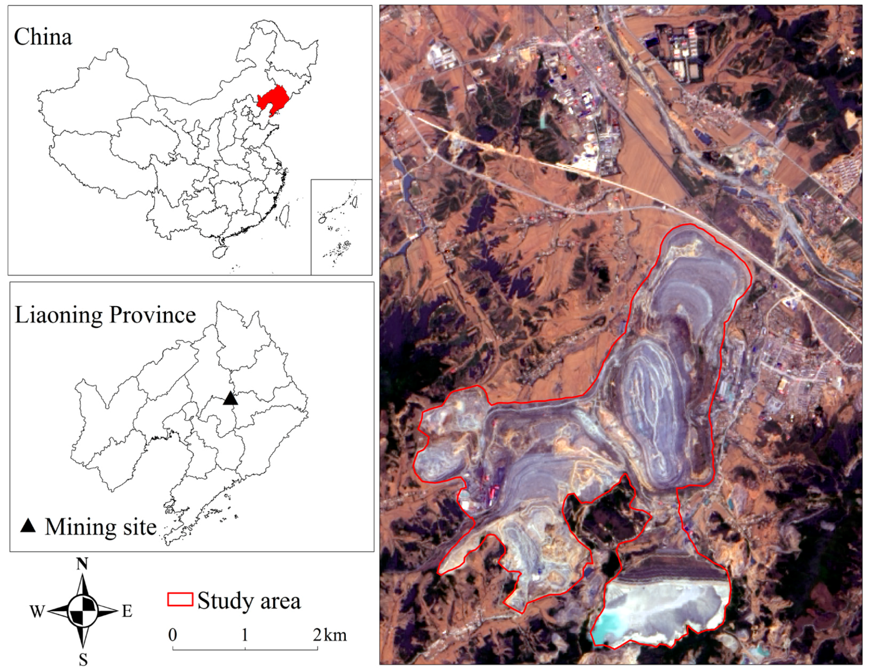
2. Study Area
3. Materials and Methods
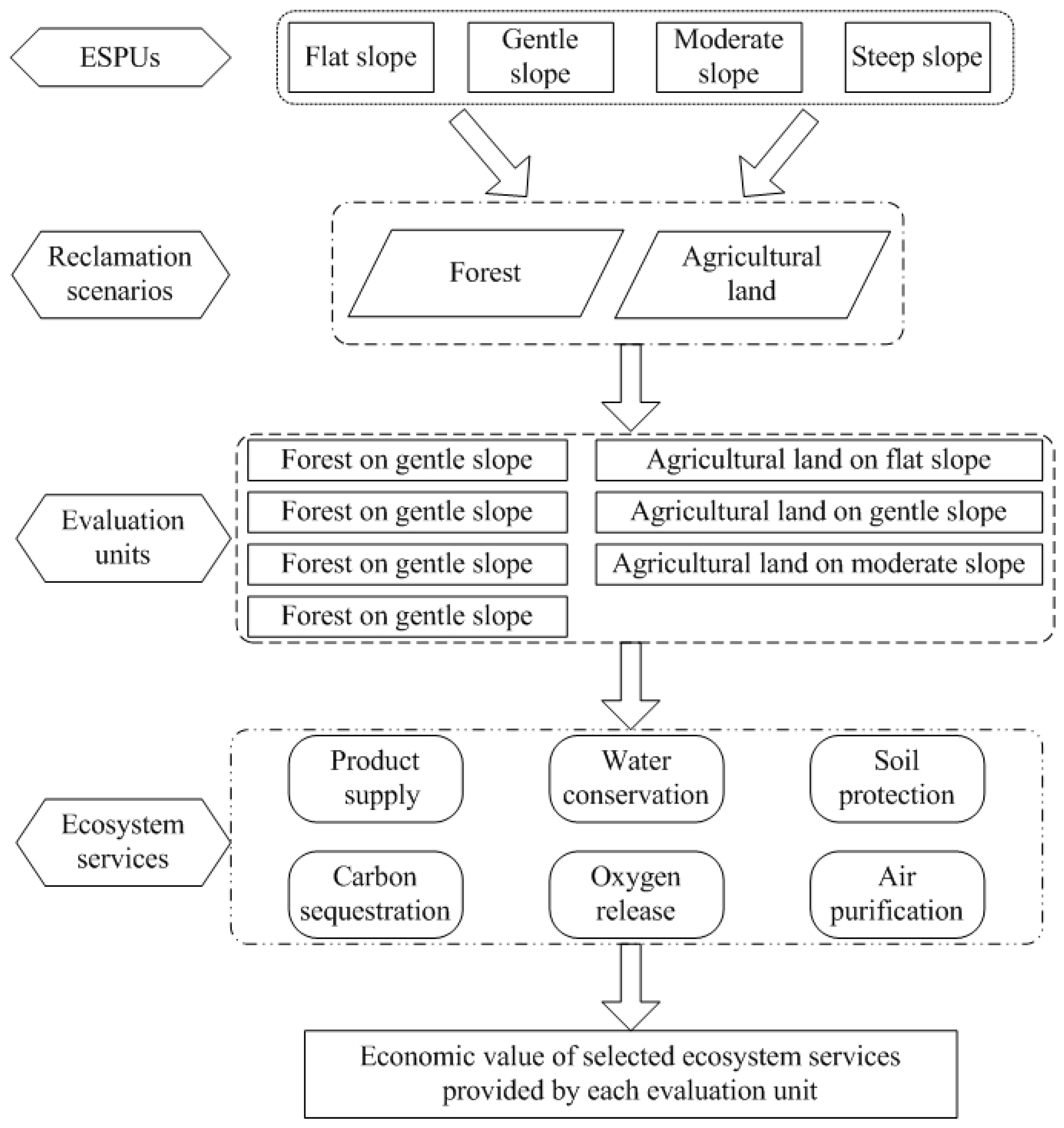
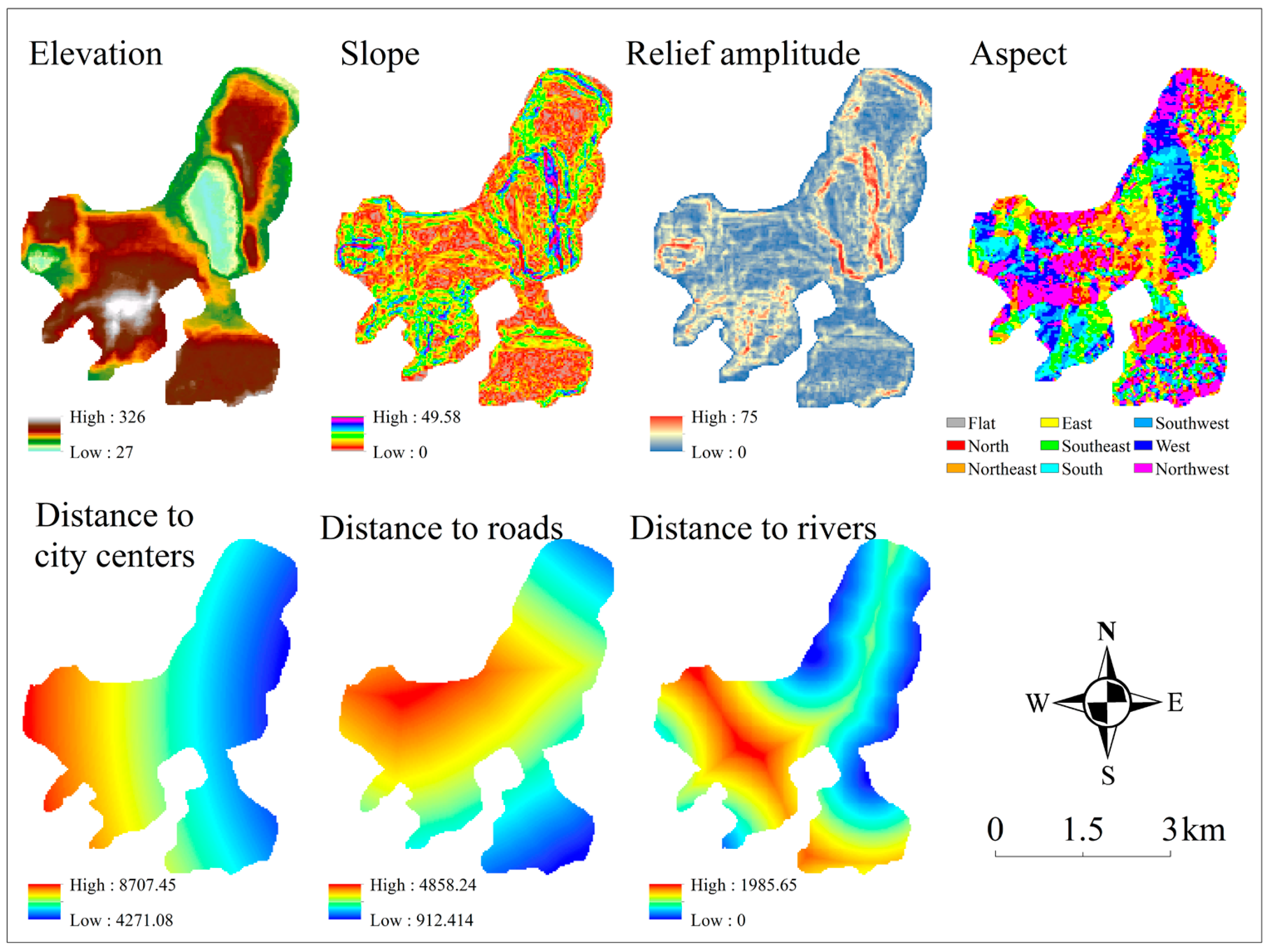
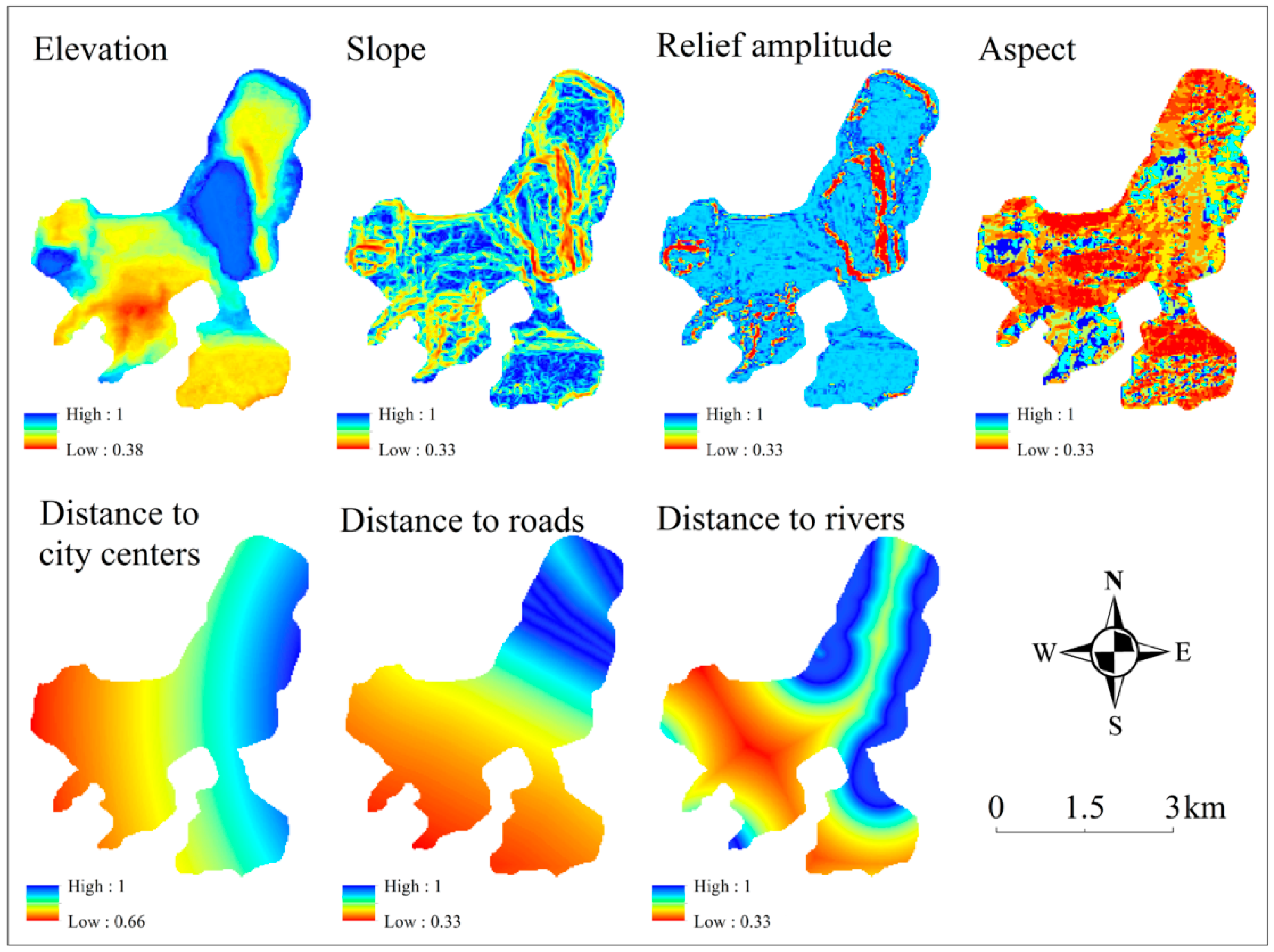
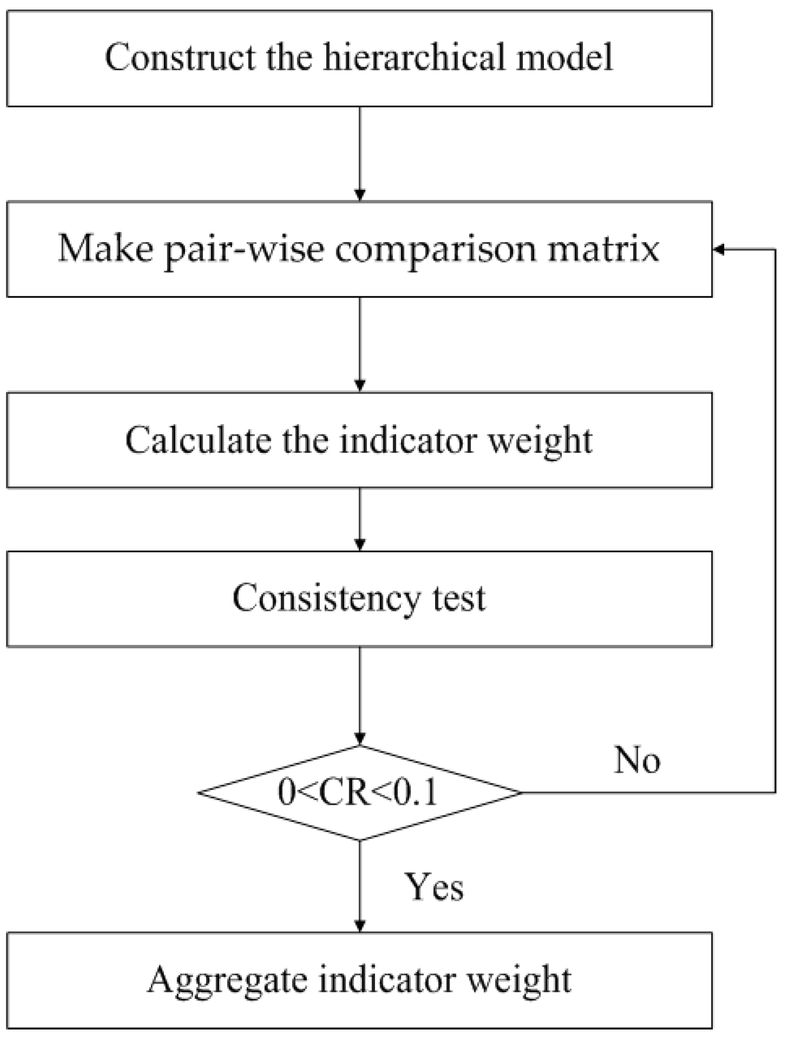
3.1. Land Suitability Analysis
3.2. Evaluation of Ecosystem Services
4. Results
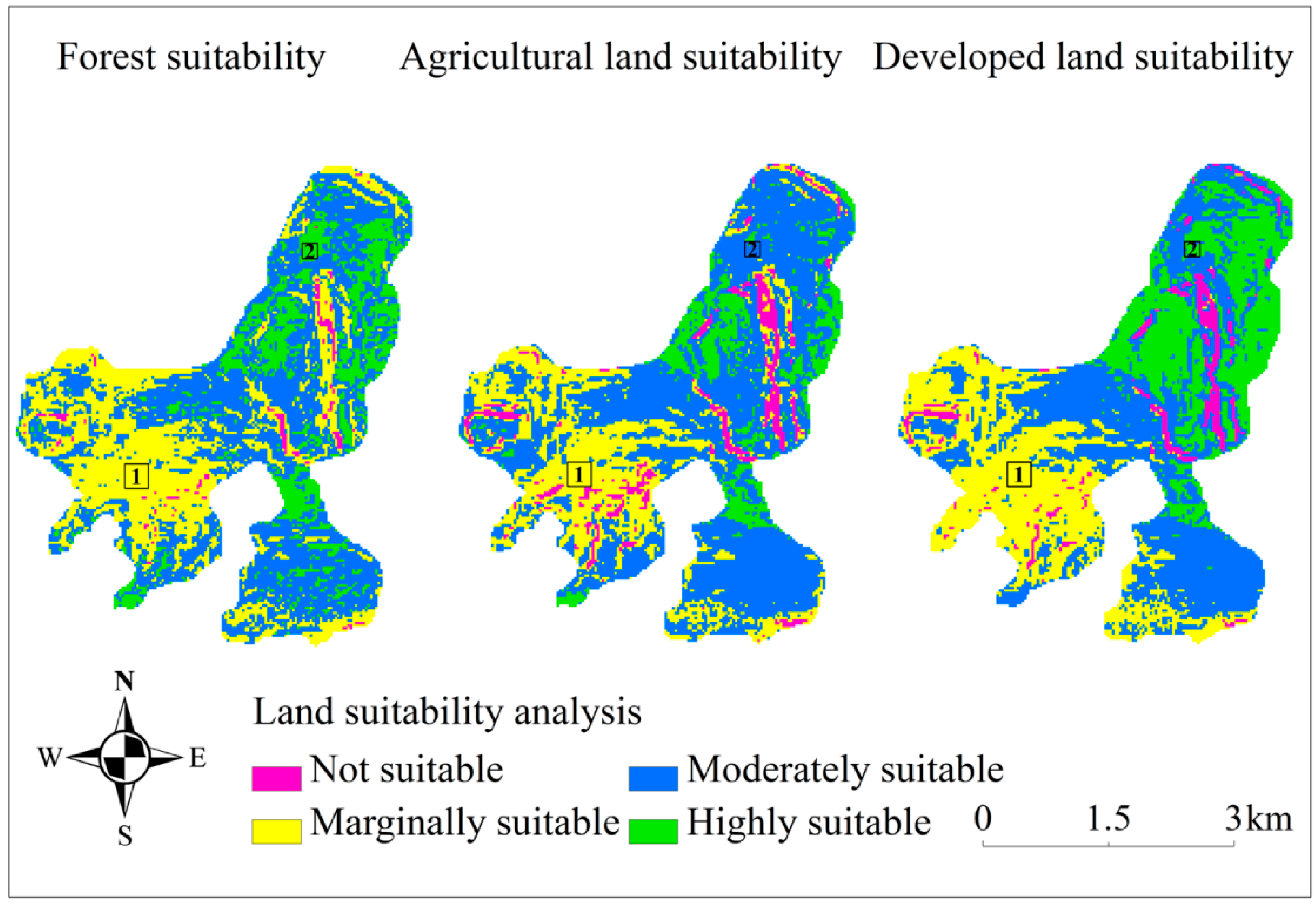
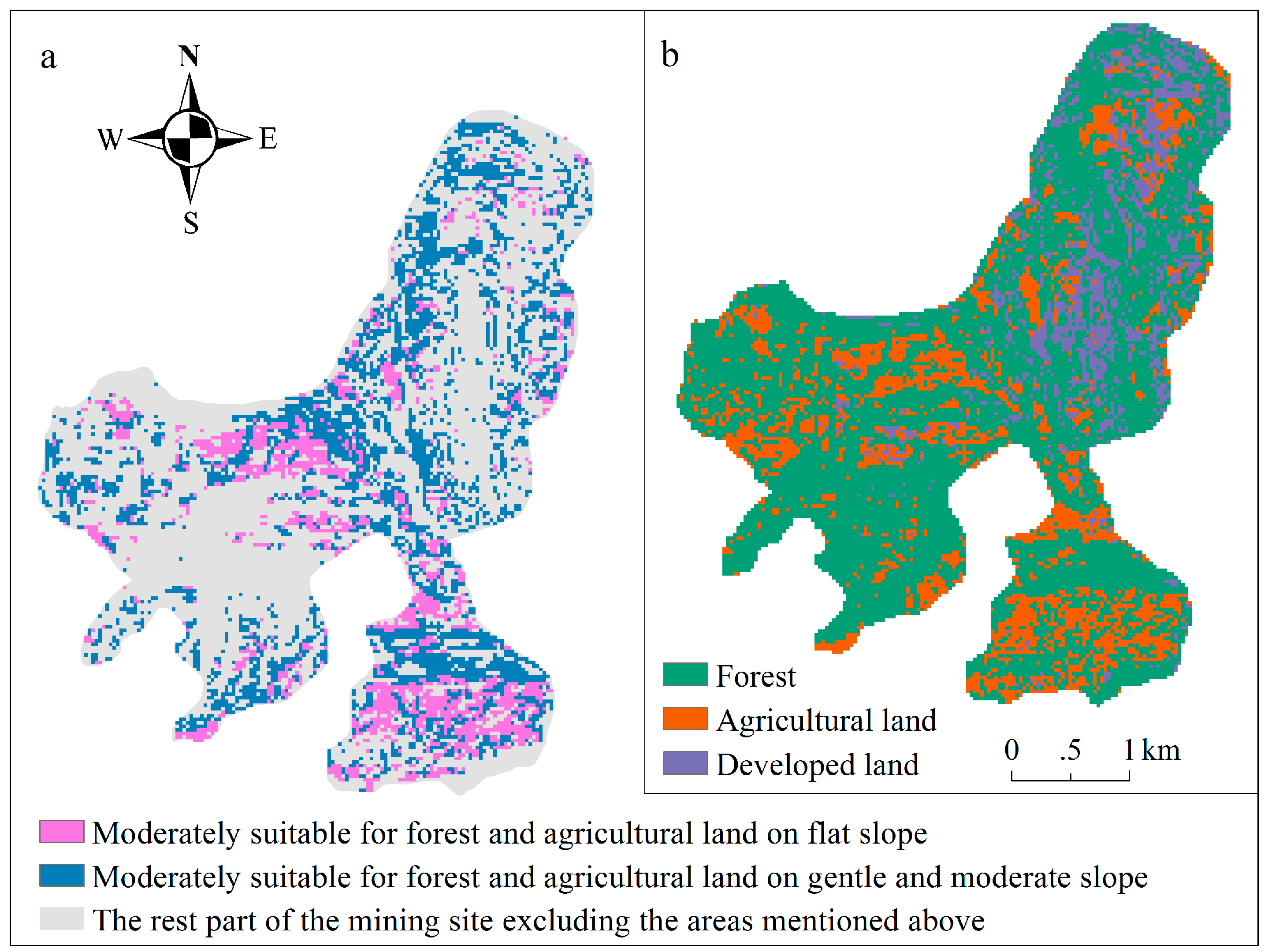
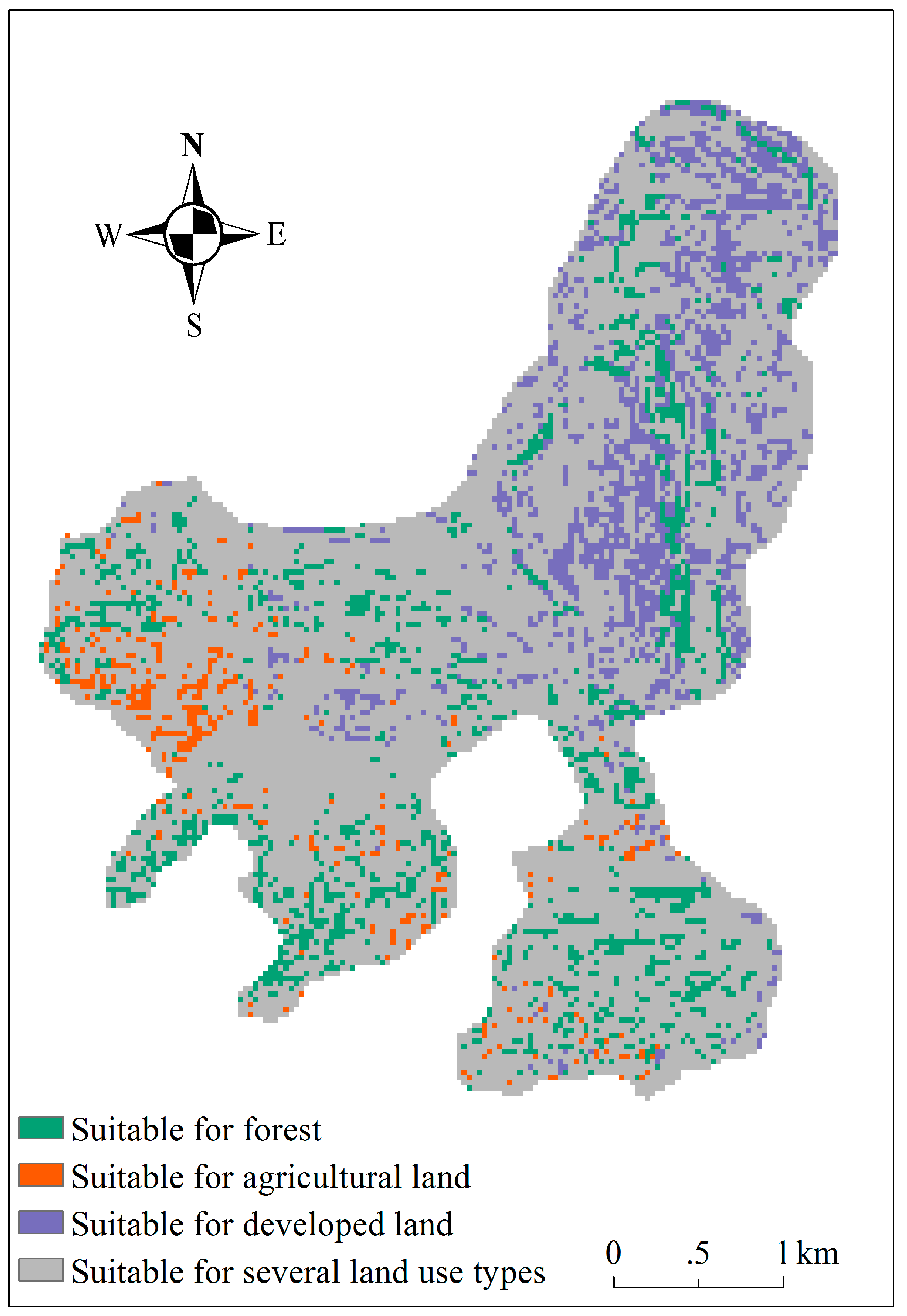
4.1. Land Suitability Analysis of Three Reclamation Alternatives
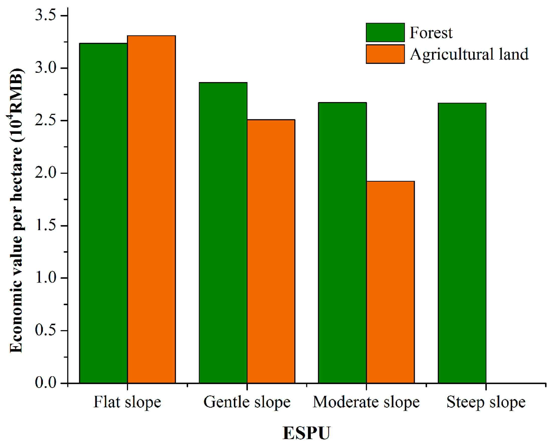
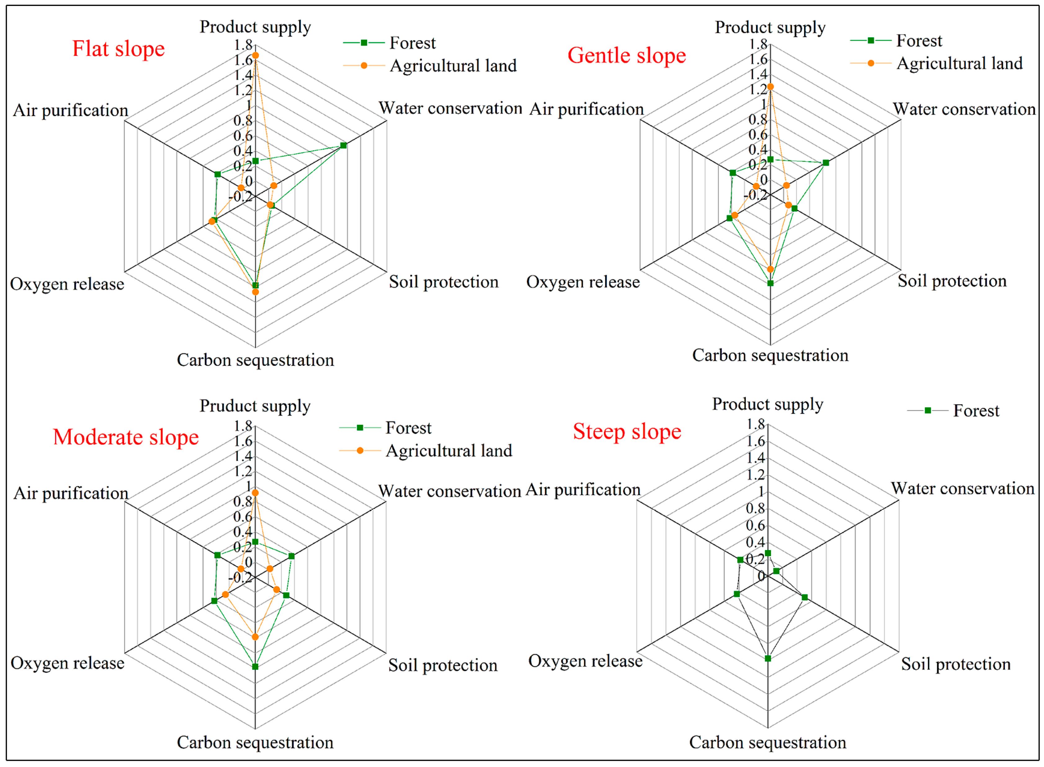
4.2. The Optimal Mining Site Reclamation Planning
5. Discussion
5.1. Integrating Ecosystem Services into Mine Reclamation
5.2. The Heterogeneirity of Future Land Use within a Mining Site
5.3. Uncertainties Involved in the Land Suitability Analysis and Ecosystem Services
6. Conclusions
Author Contributions
Conflicts of Interest
References
- Feng, X.; Fu, B.; Lu, N.; Zeng, Y.; Wu, B. How ecological restoration alters ecosystem services: An analysis of carbon sequestration in China’s Loess Plateau. Sci. Rep. 2013, 3, 2846. [Google Scholar] [CrossRef] [PubMed]
- Benayas, J.M.R.; Newton, A.C.; Diaz, A.; Bullock, J.M. Enhancement of biodiversity and ecosystem services by ecological restoration: A meta-analysis. Science 2009, 325, 1121–1124. [Google Scholar] [CrossRef] [PubMed]
- Cao, X. Regulating mine land reclamation in developing countries: The case of China. Land Use Policy 2007, 24, 472–483. [Google Scholar] [CrossRef]
- Li, F.; Liu, X.; Zhao, D.; Wang, B.; Jin, J.; Hu, D. Evaluating and modeling ecosystem service loss of coal mining: A case study of Mentougou District of Beijing, China. Ecol. Complex. 2011, 8, 139–143. [Google Scholar] [CrossRef]
- Palmer, M.A.; Wilcock, P.R. Mountaintop mining consequences. Science 2010, 327, 148–149. [Google Scholar] [CrossRef] [PubMed]
- Li, M.S. Ecological restoration of mineland with particular reference to the metalliferous mine wasteland in China: A review of research and practice. Sci. Total Environ. 2006, 357, 38–53. [Google Scholar] [CrossRef] [PubMed]
- Dal, S.P.; Ottolino, M.A.; Caliandro, L.P. Identification of quarries rehabilitation scenarios: A case study within the Metropolitan area of Bari (Italy). Environ. Manag. 2012, 49, 1174–1191. [Google Scholar]
- Zipper, C.E.; Burger, J.A.; Skousen, J.G.; Angel, P.N.; Barton, C.D.; Davis, V.; Franklin, J.A. Restoring forests and associated ecosystem services on Appalachian coal surface mines. Environ. Manag. 2011, 47, 751–765. [Google Scholar] [CrossRef] [PubMed]
- Dulias, R. Landscape planning in areas of sand extraction in the Silesian upland, Poland. Landsc. Urban Plan. 2010, 95, 91–104. [Google Scholar] [CrossRef]
- Gao, L.; Miao, Z.; Bai, Z.; Zhou, X.; Zhao, J.; Zhu, Y. A case study of ecological restoration at the Xiaoyi Bauxite mine, Shanxi Province, China. Ecol. Eng. 1998, 11, 221–229. [Google Scholar] [CrossRef]
- Sklenička, P.; Lhota, T. Landscape heterogeneity—A quantitative criterion for landscape reconstruction. Landsc. Urban Plan. 2002, 58, 147–156. [Google Scholar] [CrossRef]
- Wang, Y.; Dawson, R.; Han, D.; Peng, J.; Liu, Z.; Ding, Y. Landscape ecological planning and design of degraded mining land. Land Degrad. Dev. 2001, 12, 449–459. [Google Scholar] [CrossRef]
- Sheoran, V.; Sheoran, A.S.; Poonia, P. Soil reclamation of abandoned mine land by revegetation: A review. Int. J. Soil Sediment Water 2010, 3, 1–20. [Google Scholar]
- Wang, S.D.; Liu, C.H.; Zhang, H.B. Suitability evaluation for land reclamation in mining area: A case study of Gaoqiao Bauxite mine. Trans. Nonferrous Met. Soc. China 2011, 21, s506–s515. [Google Scholar] [CrossRef]
- Pavloudakis, F.; Galetakis, M.; Roumpos, C. A spatial decision support system for the optimal environmental reclamation of open-pit coal mines in Greece. Int. J. Min. Reclam. Environ. 2009, 3, 291–303. [Google Scholar] [CrossRef]
- Soltanmohammadi, H.; Osanloo, M.; Bazzazi, A.A. An analytical approach with a reliable logic and a ranking policy for post-mining land-use determination. Land Use Policy 2010, 27, 364–372. [Google Scholar] [CrossRef]
- Mendoza, G.A. GIS-Based Multicriteria Approaches to Land Use Suitability Assessment and Allocation. In United States Department of Agriculture Forest Service General Technical Report NC; United States Department of Agriculture: Pennsylvania, PA, USA, 2000; pp. 89–94. [Google Scholar]
- Arkema, K.K.; Verutes, G.M.; Wood, S.A.; Clarke-Samuels, C.; Rosado, S.; Canto, M.; Rosenthal, A.; Ruckelshaus, M.; Guannel, G.; Toft, J. Embedding ecosystem services in coastal planning leads to better outcomes for people and nature. Proc. Natl. Acad. Sci. USA 2015, 112, 7390–7395. [Google Scholar] [CrossRef] [PubMed]
- Kabisch, N. Ecosystem service implementation and governance challenges in urban green space planning—The case of Berlin, Germany. Land Use Policy 2015, 42, 557–567. [Google Scholar] [CrossRef]
- Prach, K.; Tolvanen, A. How can we restore biodiversity and ecosystem services in mining and industrial sites? Environ. Sci. Pollut. Res. 2016, 23, 1–4. [Google Scholar] [CrossRef] [PubMed]
- Larondelle, N.; Haase, D. Valuing post-mining landscapes using an ecosystem services approach—An example from Germany. Ecol. Indic. 2012, 18, 567–574. [Google Scholar] [CrossRef]
- Liu, J.; Li, S.; Ouyang, Z.; Tam, C.; Chen, X. Ecological and socioeconomic effects of China’s policies for ecosystem services. Proc. Natl. Acad. Sci. USA 2008, 105, 9477–9482. [Google Scholar] [CrossRef] [PubMed]
- Groot, R.S.D.; Alkemade, R.; Braat, L.; Hein, L.; Willemen, L. Challenges in integrating the concept of ecosystem services and values in landscape planning, management and decision making. Ecol. Complex. 2010, 7, 260–272. [Google Scholar] [CrossRef]
- Thompson, J.R.; Lambert, K.F.; Foster, D.R.; Broadbent, E.N.; Blumstein, M.; Almeyda Zambrano, A.M.; Fan, Y. The consequences of four land-use scenarios for forest ecosystems and the services they provide. Ecosphere 2016, 7, 1–22. [Google Scholar] [CrossRef]
- Jra, B.; Wong, G.Y.; Metcalfe, D.J.; Honzák, M.; Pert, P.L.; Rao, N.; van Grieken, M.E.; Lawson, T.; Bruce, C.; Kroon, F.J. An analysis of trade-offs between multiple ecosystem services and stakeholders linked to land use and water quality management in the great barrier reef, Australia. Agric. Ecosyst. Environ. 2013, 180, 176–191. [Google Scholar]
- Nelson, E.; Mendoza, G.; Regetz, J.; Polasky, S.; Tallis, H.; Cameron, D.; Chan, K.M.; Daily, G.C.; Goldstein, J.; Kareiva, P.M. Modeling multiple ecosystem services, biodiversity conservation, commodity production, and tradeoffs at landscape scales. Front. Ecol. Environ. 2009, 7, 4–11. [Google Scholar] [CrossRef]
- Maes, J.; Egoh, B.; Willemen, L.; Liquete, C.; Vihervaara, P.; Schägner, J.P.; Grizzetti, B.; Drakou, E.G.; Notte, A.L.; Zulian, G. Mapping ecosystem services for policy support and decision making in the European Union. Ecosyst. Serv. 2012, 1, 31–39. [Google Scholar] [CrossRef]
- Jia, X.; Fu, B.; Feng, X.; Hou, G.; Liu, Y.; Wang, X. The tradeoff and synergy between ecosystem services in the Grain-for-Green areas in northern Shaanxi, China. Ecol. Indic. 2014, 43, 103–113. [Google Scholar] [CrossRef]
- Li, B.; Zhang, F.; Zhang, L.; Huang, J.; Jin, Z.; Gupta, D.K. Comprehensive suitability evaluation of tea crops using GIS and a modified land ecological suitability evaluation model. Pedosphere 2012, 22, 122–130. [Google Scholar] [CrossRef]
- Xie, L. Suggestions for water environment management in Shenyang. Water Res. Hydropower Northeast China 2015, 33, 51–52. (In Chinese) [Google Scholar]
- Masoumi, I.; Naraghi, S.; Rashidi-Nejad, F.; Masoumi, S. Application of fuzzy multi-attribute decision-making to select and to rank the post-mining land-use. Environ. Earth Sci. 2014, 72, 221–231. [Google Scholar] [CrossRef]
- Koulouri, M.; Giourga, C. Land abandonment and slope gradient as key factors of soil erosion in Mediterranean terraced lands. Catena 2007, 69, 274–281. [Google Scholar] [CrossRef]
- Bozdağ, A.; Yavuz, F.; Günay, A.S. AHP and GIS based land suitability analysis for Cihanbeyli (Turkey) county. Environ. Earth Sci. 2016, 75, 1–15. [Google Scholar] [CrossRef]
- Liu, Y.; Deng, W.; Song, X.Q. Relief degree of land surface and population distribution of mountainous areas in china. J. Mt. Sci. 2015, 12, 518–532. [Google Scholar] [CrossRef]
- Elena Arce, M.; Saavedra, Á.; Míguez, J.L.; Granada, E. The use of grey-based methods in multi-criteria decision analysis for the evaluation of sustainable energy systems: A review. Renew. Sustain. Energy Rev. 2015, 47, 924–932. [Google Scholar] [CrossRef]
- Yang, F.; Zeng, G.; Du, C.; Tang, L.; Zhou, J.; Li, Z. Spatial analyzing system for urban land-use management based on GIS and multi-criteria assessment modeling. Prog. Nat. Sci. 2008, 18, 1279–1284. [Google Scholar] [CrossRef]
- Kuo, Y.; Yang, T.; Huang, G.W. The use of grey relational analysis in solving multiple attribute decision-making problems. Comput. Ind. Eng. 2008, 55, 80–93. [Google Scholar] [CrossRef]
- Widiatmaka; Ambarwulan, W.; Setiawan, Y.; Walter, C. Assessing the suitability and availability of land for agriculture in Tuban Regency, East Java, Indonesia. Appl. Environ. Soil Sci. 2016, 2016, 1–13. [Google Scholar] [CrossRef]
- Ma, H.; Zhou, Z.; Wu, C.; Wei, H.; Liu, X.; Tang, W. Forestland suitability evaluation and forest category structure adjustment in Xishui County based on GIS. Soil Water Conserv. China 2011, 3, 44–47. (In Chinese) [Google Scholar]
- Zhang, X.; Fang, C.; Wang, Z.; Ma, H. Urban construction land suitability evaluation based on improved multi-criteria evaluation based on GIS (MCE-GIS): Case of new Hefei City, China. Chin. Geogr. Sci. 2013, 23, 740–753. [Google Scholar] [CrossRef]
- Liu, S.; Zhao, Q.; Wen, M.; Deng, L.; Dong, S.; Wang, C. Assessing the impact of hydroelectric project construction on the ecological integrity of the Nuozhadu Nature Reserve, southwest China. Stoch. Environ. Res. Risk Assess. 2013, 27, 1709–1718. [Google Scholar] [CrossRef]
- Akinci, H.; Özalp, A.Y.; Turgut, B. Agricultural land use suitability analysis using GIS and AHP technique. Comput. Electron. Agric. 2013, 97, 71–82. [Google Scholar] [CrossRef]
- Tong, O.; Shao, S.; Zhang, Y.; Chen, Y.; Liu, S.L.; Zhang, S.S. An AHP-based water-conservation and waste-reduction indicator system for cleaner production of textile-printing industry in China and technique integration. Clean Technol. Environ. Policy 2012, 14, 857–868. [Google Scholar] [CrossRef]
- Fei, D.; Li, X.B.; Hong, W.; Meng, Z.; Li, R.H.; Xu, L. GIS-based assessment of land suitability for Alfalfa cultivation: A case study in the dry continental steppes of northern China. Span. J. Agric. Res. 2014, 12, 364. [Google Scholar]
- Zhang, B.; Gao, J.X.; Xie, G.D.; Lu, C.X. Forest soil conservation based on eco-service provision unit method and its value in Anji County, Huzhou, Zhejiang, China. J. For. Res. 2015, 26, 405–415. [Google Scholar] [CrossRef]
- Zhang, B.; Li, W.H.; Xie, G.D.; Xiao, Y. Water conservation of forest ecosystem in Beijing and its value. Ecol. Econ. 2010, 69, 1416–1426. [Google Scholar]
- Wang, X.; Bennett, J. Policy analysis of the conversion of cropland to forest and grassland program in China. Environ. Econ. Policy Stud. 2008, 9, 119–143. [Google Scholar] [CrossRef]
- Rozelle, S. Grain for green: Cost-effectiveness and sustainability of China’s conservation set-aside program. Land Econ. 2003, 81, 247–264. [Google Scholar]
- Administration, S.F. China Forestry Statistical Yearbook; Chinese Forestry Press: Beijing, China, 2015. (In Chinese) [Google Scholar]
- Morri, E.; Pruscini, F.; Scolozzi, R.; Santolini, R. A forest ecosystem services evaluation at the river basin scale: Supply and demand between coastal areas and upstream lands (Italy). Ecol. Ind. 2014, 37, 210–219. [Google Scholar] [CrossRef]
- Gao, R. Water balance of major forest types in east Liaoning mountainous region. Bull. Soil Water Conserv. 2002, 22, 5–8. (In Chinese) [Google Scholar]
- Xue, D.; Tisdell, C. Valuing ecological functions of biodiversity in Changbaishan Mountain biosphere reserve in northeast China. Biodivers. Conserv. 2001, 10, 467–481. [Google Scholar] [CrossRef]
- Guo, Z.; Xiao, X.; Gan, Y.; Zheng, Y. Ecosystem functions, services and their values—A case study in Xingshan County of China. Ecol. Econ. 2001, 38, 141–154. [Google Scholar] [CrossRef]
- Ouyang, Z.; Wang, X.; Miao, H. A primary study on Chinese terrestrial ecosystem services and their ecological-economic values. Acta Ecol. Sin. 1999, 19, 607–613. (In Chinese) [Google Scholar]
- Sun, X.; Xie, G.; Cheng, S.; Xiao, Y.; Lu, C. Services for soil conservation and its monetary value of Chinese cropping system. J. Soil Water Conserv. 2005, 19, 156–159. (In Chinese) [Google Scholar]
- Lu, S.; Jin, F.; Yu, X.; Xie, Y.; Li, Y.; Wang, S. The evaluation of soil conservation of forest ecosystem in China. Sci. Soil Water Conserv. 2005, 3, 16–21. (In Chinese) [Google Scholar]
- Jia, W. Soil in Liaoning Province; Liaoning Science and Technology Press: Shenyang, China, 1992. (In Chinese) [Google Scholar]
- Sun, X.; Zhou, H.; Xie, G. Ecological services and their values of Chinese agroecosystem. China Popul. Resour. Environ. 2007, 17, 55–60. (In Chinese) [Google Scholar]
- Ninan, K.; Inoue, M. Valuing forest ecosystem services: Case study of a forest reserve in Japan. Ecosyst. Serv. 2013, 5, 78–87. [Google Scholar] [CrossRef]
- Yang, Z.; Zheng, D.; Wen, H. Studies on service value evaluation of agricultural ecosystem in Beijing region. J. Nat. Resour. 2005, 20, 564–571. (In Chinese) [Google Scholar]
- Jim, C.; Chen, W.Y. Assessing the ecosystem service of air pollutant removal by urban trees in Guangzhou (China). J. Environ. Manag. 2008, 88, 665–676. [Google Scholar] [CrossRef] [PubMed]
- Daily, G.C.; Polasky, S.; Goldstein, J.; Kareiva, P.M.; Mooney, H.A.; Pejchar, L.; Ricketts, T.H.; Salzman, J.; Shallenberger, R.; Ruffo, S. Ecosystem services in decision making: Time to deliver. Front. Ecol. Environ. 2009, 7, 21–28. [Google Scholar] [CrossRef]
- Blaen, P.J.; Jia, L.; Peh, K.S.; Field, R.H.; Balmford, A.; Macdonald, M.A.; Bradbury, R.B. Rapid assessment of ecosystem services provided by two mineral extraction sites restored for nature conservation in an agricultural landscape in eastern England. PLoS ONE 2015, 10, e0121010. [Google Scholar] [CrossRef] [PubMed]
- Lei, K.; Pan, H.Y.; Lin, C.Y. A landscape approach towards ecological restoration and sustainable development of mining areas. Ecol. Eng. 2016, 90, 320–325. [Google Scholar] [CrossRef]
- Maczkowiack, R.I.; Smith, C.S.; Slaughter, G.J.; Mulligan, D.R.; Cameron, D.C. Grazing as a post-mining land use: A conceptual model of the risk factors. Agric. Syst. 2012, 109, 76–89. [Google Scholar] [CrossRef]
- Baja, S.; Chapman, D.M.; Dragovich, D. Spatial based compromise programming for multiple criteria decision making in land use planning. Environ. Model. Assess. 2007, 12, 171–184. [Google Scholar] [CrossRef]
- Zipper, C.E.; Burger, J.A.; Evans, D.M.; Donovan, P. Young forest composition and growth on a reclaimed Appalachian coal surface mine after nine years. J. Am. Soc. Min. Reclam. 2012, 1, 56–84. [Google Scholar] [CrossRef]
- Simmons, J.A.; Currie, W.S.; Eshleman, K.N.; Kuers, K.; Monteleone, S.; Negley, T.L.; Pohlad, B.R.; Thomas, C.L. Forest to reclaimed mine land use change leads to altered ecosystem structure and function. Ecol. Appl. 2008, 18, 104–118. [Google Scholar] [CrossRef] [PubMed]
- Sena, K.; Barton, C.; Hall, S.; Angel, P.; Agouridis, C.; Warner, R. Influence of spoil type on afforestation success and natural vegetative recolonization on a surface coal mine in Appalachia, United States. Restor. Ecol. 2015, 23, 131–138. [Google Scholar] [CrossRef]
- Miao, Z.; Marrs, R. Ecological restoration and land reclamation in open-cast mines in Shanxi Province, China. J. Environ. Manag. 2000, 59, 205–215. [Google Scholar] [CrossRef]
- Ruiz Ballesteros, E.; Hernández Ramírez, M. Identity and community—Reflections on the development of mining heritage tourism in southern Spain. Tour. Manag. 2007, 28, 677–687. [Google Scholar] [CrossRef]
- Zhang, J.; Fu, M.; Hassani, F.P.; Hui, Z.; Geng, Y.; Bai, Z. Land use-based landscape planning and restoration in mine closure areas. Environ. Manag. 2011, 47, 739–750. [Google Scholar] [CrossRef] [PubMed]


| Evaluation Factors | Forest Suitability | Agricultural Land Suitability | Developed Land Suitability | |||
|---|---|---|---|---|---|---|
| Optimal Value | Weight | Optimal Value | Weight | Optimal Value | Weight | |
| Elevation (m) | 0 | 0.1279 | 0 | 0.1301 | 0 | 0.0929 |
| Slope (°) | 0 | 0.2856 | 0 | 0.2659 | 0 | 0.2074 |
| Aspect | South (9) | 0.1661 | South (9) | 0.1677 | South (9) | 0.1206 |
| Relief amplitude (m) | 0 | 0.2585 | 0 | 0.2417 | 0 | 0.1986 |
| The distance to rivers (m) | 0 | 0.1619 | 0 | 0.1946 | (500–1000) | 0.1189 |
| The distance to roads (m) | — | — | — | — | (0–1000) | 0.1497 |
| The distance to city centers (m) | — | — | — | — | 0 | 0.1119 |
| Land Suitability Level | Forest Suitability | Agricultural Land Suitability | Developed Land Suitability | |||
|---|---|---|---|---|---|---|
| Area (ha) | Proportion (%) | Area (ha) | Proportion (%) | Area (ha) | Proportion (%) | |
| Not suitable | 20.75 | 1.55 | 83.81 | 6.27 | 68.64 | 5.13 |
| Marginally suitable | 443.13 | 33.14 | 349.75 | 26.16 | 394.62 | 29.52 |
| Moderately suitable | 646.93 | 48.39 | 762.98 | 57.07 | 567.91 | 42.48 |
| Highly suitable | 226.19 | 16.92 | 140.46 | 10.51 | 305.83 | 22.87 |
© 2017 by the authors. Licensee MDPI, Basel, Switzerland. This article is an open access article distributed under the terms and conditions of the Creative Commons Attribution (CC BY) license (http://creativecommons.org/licenses/by/4.0/).
Share and Cite
Wang, J.; Zhao, F.; Yang, J.; Li, X. Mining Site Reclamation Planning Based on Land Suitability Analysis and Ecosystem Services Evaluation: A Case Study in Liaoning Province, China. Sustainability 2017, 9, 890. https://doi.org/10.3390/su9060890
Wang J, Zhao F, Yang J, Li X. Mining Site Reclamation Planning Based on Land Suitability Analysis and Ecosystem Services Evaluation: A Case Study in Liaoning Province, China. Sustainability. 2017; 9(6):890. https://doi.org/10.3390/su9060890
Chicago/Turabian StyleWang, Jiali, Fuqiang Zhao, Jian Yang, and Xiaoshu Li. 2017. "Mining Site Reclamation Planning Based on Land Suitability Analysis and Ecosystem Services Evaluation: A Case Study in Liaoning Province, China" Sustainability 9, no. 6: 890. https://doi.org/10.3390/su9060890