From Perceived Values to Shared Values: A Multi-Stakeholder Spatial Decision Analysis (M-SSDA) for Resilient Landscapes


Department of Architecture (DiARC), University of Naples Federico II, 80134 Naples, Italy
*
Author to whom correspondence should be addressed.
Sustainability 2017, 9(7), 1113; https://doi.org/10.3390/su9071113
Submission received: 1 February 2017
/
Revised: 14 June 2017
/
Accepted: 14 June 2017
/
Published: 26 June 2017
(This article belongs to the Special Issue Decipher the Present to Shape the Future- Rethinking the Urban–Rural Nexus)
Abstract
:This paper puts forth a Multi-Stakeholder Spatial Decision Analysis (M-SSDA) which combines Multi-Stakeholders Decision Analysis (M-SDA) and GIS processing based on a collaborative, hybrid and adaptive evaluative approach to support the elaboration of enhancement strategies designed for resilient landscapes. This methodology has been tested in the research project “Cilento Labscape: An integrated model for the activation of a Living Lab in the National Park of Cilento, Vallo di Diano and Alburni”, which was conducted in the Cilento National Park (Southern Italy). The aim of the methodology is to find alternative touristic routes for the promotion of the Park. The different steps in the process will be described, as will the employment of multiple tools/techniques (interviews, GIS tools, Semantic Analysis, and Geo-Statistical Analysis) to improve the reliability of the decision-making process. The most relevant results of the methodology will also be outlined in terms of the transition from the identification of the perceived landscape’s values to the acknowledgement of the shared values, and their consequent employment for the outlining of new thematic itineraries for the Park. To realise sustainable territorial strategies and preserve the landscape through bottom-up decision-making processes, the different local communities need to gain a new awareness of their identity shared values and make an active contribution towards promoting and managing their site-specific resources.
1. Introduction
The intrinsic interdisciplinarity and multiscalar characteristics of a landscape make it possible to identify a very flexible, changing, and evolving context, where the biological, cultural, and biophysical components interact and where resilience is conceived as the expression of the diversity of the elements, which thrive together in a co-evolution and regeneration process, and in an interconnected system resistant to shock and, at the same time, adaptive to change [1,2].
The concept of resilient landscape, first from the ecological studies perspective, indicates the time required for an ecosystem to recover its equilibrium or steady-state following a perturbation [3,4,5,6]. However, in environmental studies, resilience has denoted the effort of a complex socio-ecological system to undergo changes, withstand stress, absorb crises, and survive by finding a new balance [7,8]. Landscape resilience can be conceived as a social benefit of the collective effort to build cooperative capacity to react and to respond creatively, preventively, and proactively to changes while learning to live with rapidly evolving conditions [9,10]. The landscape is the result of humans’ actions and their interactions with the environment. This fact gives rise to the issue of how to preserve the local communities’ cultural heritage while maintaining the heterogeneity of local life, activities, and resources, the methods of responding to current challenges, and their identity in the present as a result of their resilient capacity [11]. This issue has become particularly relevant when considering those areas where a precious historical heritage has made (or could make) tourism the main goal of local development and the source of economic income, especially in terms of the sustainability aspect [12,13].
In many cases, preserving heritage for touristic purposes has meant the freezing of entire areas, or even cities, by making the landscape a mere exhibition of the past [14,15]. In fact, touristic overexploitation has sometimes threatened the same heritage, to which had only been assigned an economic value. On the contrary, sustainable development strategies must focus on keeping alive landscape resilience, or rather the adapting attitude of a local community to present times, which is inherently impressed into the changing of the landscape [16,17].
On the other hand, however, excessive and extensive actions on the landscape have often dramatically altered the landscape balance, nullifying the signs of the past, and the historical heritage stratified in the landscape, thus making it an alienating “waste land”. Indeed, this is what happened so frequently in the previous century, and what continues to happen so dramatically, wherever an aggressive (mostly industrial and urban) development has completely ignored environmental and sustainability issues [18,19,20,21,22].
The studies on landscape resilience, therefore, fall within the realm of environmental research aimed at achieving sustainable development and heritage preservation [23,24]. The data and the issues deduced from a thorough investigation of the landscape and local communities’ relationships intend to provide wider knowledge for measures and policies of environmental, historical, and cultural enhancement. In this field, particular attention should be paid to searching for the resilient factors within the landscape, as these bring about signs of the organic relation between local communities and the surrounding environment over time in terms of their resistance and reaction to changes. Indeed, all of this leads to a conception of the landscape as a complex, non-linear, interconnected spatial system [25,26].
In accordance with the evolutionary resilience perspective [27,28], the making of the landscape’s framework involves the operation of various economic, ecological, sociological, historical, cultural, and spatial factors on multiple scales and timescales, with extensive and unpredictable feedback processes [29]. A resilient landscape inserts within the urban metabolism the management of new cycles which better respond to external shocks, characterised by rhythms of elasticity (being self-regulating, dynamic and evolving), retroactivity (being multiscalar, incremental and cumulative) and socio-ecological multifunctionality (being adaptive, qualitative and re-cyclable) [9,30,31].
This complexity requires a multidimensional evaluative approach, where different kinds of features are investigated in terms of their concurrent defining of the landscape. These characteristic features are not only objective, but also subjective, and result from how people perceive and esteem the surrounding environment [32]. In studying and evaluating landscape resilience for sustainable development, people’s involvement is essential: surveying different opinions, points of view, observations, tallies, perceptions and experiences about the landscape helps to understand the related identity and relational values [33,34]; indeed, such an understanding should be preserved in landscape management and enhancement policies [35,36]. From this perspective, considering subjective indicators is in line with other analogous studies aimed at site-specific sustainable development [37,38,39], such as those supporting bottom-up approaches and collaborative decision-making processes, where local communities are called upon to make a relevant contribution in resources management to promote place-based development [40].
This is a recent open research issue, with prominence given to the subjective indicators regarding local standards of living and well-being, since they are more likely to head local policies [38,41,42]. A relevant example in this direction is represented by the OECD approach to measuring well-being [43] and Sustainable Development Goal (SDG) indicators [44] which include subjective or perception-based indicators. However, the use of subjective indicators raises some methodological issues due to the subjective information that they provide [42,45]. These issues mostly concern how to trace points and elements of general interest from this subjective data to reflect the specificity of each particular landscape and its associated communities, and to make people’s involvement concretely effective for new landscape policies.
This paper describes a case study which tests an evaluative methodological process using the elaboration of subjective indicators to identify sustainable promotional strategies for the enhancement of resilient landscapes. The study is part of the larger research project “Cilento Labscape: An integrated model for the activation of a Living Lab in the National Park of Cilento, Vallo di Diano and Alburni”, Finanziamento per l’Avvio di Ricerche Originali (F.A.R.O.) programme, Department of Architecture (DiARC), University of Naples Federico II. The aim of the living lab “Cilento Labscape” is to improve the partnership between different local communities, researchers, private actors, and local governance, in order to promote cooperation and thus create the conditions needed for sustainable transformations; these conditions stem from mutual and increased learning, and are capable of meeting local specific needs [46].
The investigation of landscape perception, carried out in different municipalities of the National Park, combines Multi-Stakeholder Decision Analysis (M-SDA) and GIS processing in a Multi-Stakeholder Spatial Decision Analysis (M-SSDA); indeed, the aim is to define a hybrid approach which can be used to gather and organise collective knowledge to produce shared values, starting with the identification of perceived values [33,34,47]. Indeed, as part of this project, a model was designed to interpret landscape values assigned by locals and visitors to specific Park areas; key to this model is the in-depth consideration of issues related to the elaboration of subjective indicators as a suitable tool for resilient landscape assessment. Indeed, such indicators help to describe and interpret how people perceive and esteem the surrounding environment [32]; they are also useful for elaborating on new situated policies and bottom-up site-specific actions. Section 1 introduces the case study, while Section 2 presents materials and methods, and Section 3 focuses on some results from the methodological process; finally, Section 4 includes discussion and conclusion.
1.1. Case Study
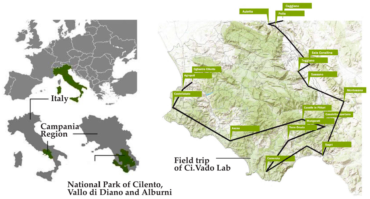
The research project “Cilento Labscape: An integrated model for the activation of a Living Lab in the National Park of Cilento, Vallo di Diano and Alburni” aimed to integrate the approach of Living Labs [48,49] into the landscape enhancement process; this involved structuring an interpretive and evaluative model implemented in local realities of the National Park of Cilento, Vallo di Diano and Alburni, in the South of Italy (Figure 1).
The Cilento National Park is a UNESCO site and a Geo-Park, i.e., a territory with a unique heritage quality and geological variety. It covers a wide and heterogeneous area, made up of littoral zones which attract many tourists in the summer; it also comprises inland zones which are scarcely inhabited, and which seek to rely on their cultural and environmental heritage to promote their land and thereby face the threat of depopulation [50].
To promote innovative ways of managing and enhancing local resources, the project was broken down into five territorial laboratories, namely “Ci.Vado”, “Ci.Torno”, “Ci.Abito”, “Ri.Uso”, and “Ri.Vivo”; indeed, these are run in different areas of the Park. The laboratories are designed as an itinerant workshop in the Park, with the purpose of identifying and developing innovative micro-actions to promote landscape awareness with the cooperation of local stakeholders.
The case study presented in this paper is the “Ci.Vado” territorial laboratory. The “Ci.Vado” lab intends to meet the needs of the Park’s inland communities, and appeal to tourists, with their capacity to maintain an osmotic relation with their environment while tackling present and future challenges. This resilient capacity marks the genuine identity of these communities and their landscape; as such, the lab starts by seeking the identity factors of the landscape in order to find new touristic routes for an alternative model of Park resources promotion.
2. Materials and Methods
The entire research project follows the Living Lab’s approach. The ENoLL [51] identifies Living Labs (LLs) as user-centred, open innovation ecosystems based on the systematic user co-creation approach, integrating research and innovation processes in real life communities and settings. They operate as intermediaries among citizens, research organisations, companies, cities, and regions for joint value co-creation, and rapid prototyping or validation to scale up innovation and businesses. LLs are improving the partnerships between varied stakeholders aimed at local innovation, and are becoming increasingly embedded in regional policies. This regional dimension is emerging as a new approach to achieve the objectives of local development [52,53]. In the Cilento Labscape Living Lab, the different laboratories were activated with consideration given to the methodological steps of the Living Lab approach (Planning, Co-Design, Testing, and Evaluating). These steps were revised and attention was paid to implementing a tailor-made process, organised into the following steps:
- -
- Exploring, identifies and finds a group of local stakeholders to work with so as to achieve shared objectives.
- -
- Co-Designing, develops and designs with specific groups of citizens the transformations that could meet their needs, demands, and expectations.
- -
- Testing, tries, with local actors, new ways of promoting the landscape and implementing micro-actions which are useful in testing modalities to enhance and manage local resources.
- -
- Co-Evaluating, increases the knowledge of the landscape values on which the micro-actions of transformation should be based.
More specifically, the paper shows the Ci.Vado’s co-evaluation process, which has been divided, in turn, into four main steps:
- Setting up survey tools: Setting up the survey with in-depth interviews, in accordance with the Cultural Values Model [54] to collect soft-data related to landscape perceptions for two selected groups of people (insiders and outsiders).
- Processing of soft investigations: Processing soft-data through the Semantic Analysis of the in-depth interviews obtained by the survey [55] to get relevant subjective indicators related to landscape perception and the place names where the interviewees identified their own factors of value.
- Setting spatial representation model: Recording on a Geographic Information System (GIS) the information supplied by the respondents (favourite place names and their relative weight), analysis, and mapping of the perceived landscape.
- Elaborating thematic maps: Making new thematic routes within the Park considering the results of previous steps and connecting the places of value identified by insiders and outsiders. This stage employs as well the Geo-Statistical techniques of GIS tools.
The different steps combine Multi-Stakeholder Decision Analysis (M-SDA) and GIS processing in a Multi-Stakeholder Spatial Decision Analysis (M-SSDA) (Figure 2); the aim of this methodological process is to identify the landscape perceived values that can guide the selection of new thematic routes, facilitate the expression of the shared values, and make it possible to activate a bottom-up strategy for the Park valorisation.
2.1. Setting up Survey Tools: The Cultural Values Model Approach
Studies on landscape perception have examined the personal experience of a determinate environment encountered by specific groups of people and their expectations. These studies have usually started by recognising the general disposition of users toward a certain landscape; why it was important to experience it, what brought them to do it, the key factors and the positive or negative features related to the personal perception of the landscape [56,57].
In Ci.Vado’s co-evaluation process, the survey begins with interviewing people about their perception of the Park’s landscape. The structure of the interviews follows the research approach on cultural values put forth by the Cultural Values Model [54]. This dynamic model sees the landscape as a living being which comprises the forms (natural features, contemporary features, human-made features, historic features, etc.), relations (sense of community, stories, feeling of belonging, sense of place, etc.) and practices (ecological processes, historical processes, human activities, historical events, etc.), which, over the course of time, have determined its present shape and expression of embedded values. They convey the cultural values of the landscape and are seen as the bases of a local community’s identity, as they are the result of its relation with the environment that they have inhabited and changed over time. Despite that, these values are not easily recognisable, but must be properly investigated, with help from targeted surveys of people’s perceptions of the landscape; indeed, this will make it possible to determine which ones are shared by the entire community and to decipher their local meanings.
The Cultural Values Model develops a holistic conceptual framework for considering the diversity of cultural values that might exist in any given landscape, and how these might relate to and reinforce one another (Figure 3).
As such, the model is dynamic and represents landscape as a continuum, bearing within it the forms, relationships and practices of the past that influence those of the present, and thereby shaping the landscape, as it is perceived. These components give rise to, and result from, cultural values in the landscape. At the same time, the perceived values, when they become an expression of relations and ties between people and places, can be conceived as shared values, whereby insiders and outsiders from stakeholders become shareholders [58,59]; these shareholders are able to share common landscape values as the result of an interactive process that triggers the creation of new communities, identified in common values.
Indeed, shared values can be defined as “glue values” [60,61] which bind common perceived values together through the relations and ties which result from a common experience, considering communal values and collective intentionality. The concept of shared value has often been used to refer to values that are “shared” by groups or communities, as well as to cultural values more generally or those which are synonymous with public values [62] and result from deliberative and social processes. Indeed, shared values may also refer to values held in common by groups in particular contexts [63].
Shared values imply that insiders and outsiders can acknowledge a common set of values and goals that can minimise their divergent interests, enhance their sense of mutual interdependence, and internalise common perceived values and goals [64,65]. Perceived values and shared values are essential components of landscape values, and an expression of their capacity to be resilient: forms, relations and practices are the instruments used to consolidate the relationship between the different perceptions, the cultural values and the actions on the landscape.
To define these meanings, the Cultural Values Model [54] opts for an open and in-depth survey, which addresses people from different places. Specifically, Stephenson has identified two broad groups:
- -
- Insiders: People who live, work, or have their roots in a given context, and express an internal point of view, which is the result of collective knowledge.
- -
- Outsiders: Visitors, tourists, or researchers, and offer a different perspective on the same context.
Insiders and outsiders understand and create the landscape around them through the filter of their social and cultural background. Thus, both forms of knowledge help in understanding the cultural values of the landscape.
2.1.1. The Identification of Survey Questions
The Cultural Values Model’s survey uses an interview model, based on simple and general open-ended questions. Following the same approach, the questions asked to insiders and outsiders of the Cilento National Park were as follows:
- What is important for you in this landscape? Why?
- Which feelings do you link to these features?
- In which places within the Park do you find them?
- Are they important places for your life? Or for your community? Why?
- Would you recommend visiting them? Why?
- Is there any route that you would suggest? To who?
- When would be the best time to visit the park?
- Could you find a motto to sum up your way of living and to promote the Park?
The first question belonged to the Cultural Values Model and made it possible to find the values assigned to the studied landscape; this type of question can concern both geographical and perceptive features as well as, more generically, immaterial ones. The second question delves into the subjective perception of the interviewees, seeking the subjective meaning of landscape values. The third provides the place names where people find those peculiar features. The fourth and the fifth question seek to identify the importance of the places indicated by the respondents according to their personal knowledge of the Park. Questions 6, 7, and 8 provide information on the elements of collective interest to be considered for creating the new touristic routes within the Park. All of the interviews made it possible to identify the subjective indicators of the landscape, i.e., the subjective parameters related to the qualitative features and the level of satisfaction, concern, and trust, regarding a given environment. These indicators are very significant for any research aimed at sustainable development, as they aid in acknowledging the identity values held by the same community, which should be preserved in the local development policies. Indeed, the use of subjective indicators enables us to understand the emotional component given to the experience of a certain place. The use of subjective indicators is affected by the subjective character of the collected information. Since the qualitative elements relate to people’s perceptions, they are influenced by many social and subjective factors such as personal experience, personal expectations, cultural background, etc. In order to design thoroughly reliable new touristic routes for landscape promotion, it was relevant to consider the sample of people to interview, how to extract elements of collective interest from the collected subjective information and classify it, and how to represent it in the space. More specifically, it was important to map the perceived features of the landscape, and their meanings, which places were reckoned more important than others on the basis of specific personal experience, and which are the routes suggested by the interviewees. Table 1 shows the survey questions, and the related detected data, aims and outputs.
2.1.2. The Selection of Interviewees
The first issue regarding the use of subjective indicators in the investigation was the selection of the interviewees. Indeed, this investigation addressed a specific group of people with the same interest in the landscape and its heritage. The sample was gathered in the following way:
- -
- The first step involved identifying local stakeholders that promote the Park in alternative ways, beyond the traditional forms of tourism, which have resulted in land consumption, speculation, and the loss of local identity.
- -
- Thereafter, as per their participation in local events, the insiders and the outsiders were found for the quality survey on the landscape.
Following the approach of the Cultural Values Model, insiders were selected: the inhabitants who take part in the events, and the inhabitants recognised by the community as experts. Among the outsiders, the following were selected: the researchers involved in academic meetings and research, those with a deep knowledge of the local landscape, and tourists visiting the area who are interested in widening their experience and knowledge of the Park.
Thanks to the partnership with local stakeholders, it was possible to understand the insiders’ and outsiders’ perceptions of the landscape and support local stakeholders in improving their Park’s knowledge of enhancement activities.
2.2. Processing of Soft Investigations: From Perceived Values to Shared Values
Following this, the data collected in the interviews were processed by means of Semantic Analysis [66]. At this point, and on the basis of their recurrence in the interviews verified through a frequency analysis, a selection of relevant key-words was recognised. Furthermore, a comparison of the key-words from all the interviews made it possible to find four main semantic fields for the insiders group: Discovery, Identity, Well-Being, and Nature. In addition, three of these fields were found for the outsiders group: Discovery, Well-Being, and Nature. These semantic fields are the clusters of subjective indicators and represent the landscape’s identity values shared by the interviewees. It is noteworthy that, except for Identity, these values are the same for both insiders and outsiders.
At this stage of the analysis of individuals’ perceptions of the landscape, elements of collective interest begin to appear. Despite deriving from subjective judgments, the values Discovery, Well-Being, and Nature, acquire some objectivity now, and can be defined as shared-values of the landscape (at least for the selected group of interviewees); this is because all of the landscape users have recognised them. Therefore, the shared values will inspire new strategies for the touristic enhancement of the Park and, in our specific case, they will serve as the topics for the alternative touristic routes.
Once the main semantic fields had been identified, the interviews were classified again accordingly. Thereafter, through a new frequency analysis, it was possible to identify new recurring elements associated with each main semantic field (linked-words) which helped to interpret their local meaning: in what the users of the territory find that particular shared value. To cite an instance, in gathering together all the interviews concerning the Discovery semantic field, it emerged (from this second analysis) that it was connected to the local heritage and culture in the interviewees’ opinion, and mostly to the small historical centres of the Park’s inland, now almost abandoned (Table 2). Consequently, a possible route on the topic of the Park’s discovery should include the small inland historical centres in a state of abandon.
2.3. Setting Spatial Representation Model and Elaborating Thematic Maps
In order to outline the new touristic routes in the Park conforming to the values shared by the interviewees, the research had to consider the geographical scale of the individual perceptions. The data emerging from the interviews were, as stated previously, a collection of subjective judgments on preferred places and other perceived features; indeed, the data showed how the perceived landscape hardly ever are delimited within the administrative and geographical boundaries. Hence, the mapping of these data gave rise to new difficulties in terms of the analysis. Past research in this field has indicated that the qualitative aspects can more easily be recognised, and so mapped, on a local scale [67,68]. In our case, the local scale relative to landscape perception has been investigated by the study.
According to the above considerations, in the Ci.Vado investigation people were asked about the places in the Park where they find a particular personal feeling (Question 3), and the routes that they would recommend visiting (Question 6). Focused on specific locations within the Park area, the answers to these questions provided valuable information; indeed, the mentioned locations were recorded in QGIS, an Open Source Geographic Information System [69], which made it possible to produce a model for the spatial representation of the perceived landscape [70]. However, even the computer record of these data posed some fairly problematic issues.
The first complication pertained to the names given by the interviewees to the mentioned places: a familiar place could be referred to with different levels of accuracy (e.g., the toponym, the municipality name, the name of a district, neighbourhood, place) or a local common name could be used, in contrast with the toponym. It was also the case, for example, that a river, a mountain, a valley, a seashore, and a historical town were perceived, and thus described, as unique entities. To deal with these interpretative problems, Google Earth and Panoramio [71] proved very useful. For instance, the Panoramio application, an archive of geo-localised photos shared among users, was employed to map places which were referred to using a nickname. Thanks to its users, who had often tagged their pictures with that nickname, it was possible to detect many unconventionally named locations.
The second difficulty stemmed from the fact that not all the places mentioned by the interviewees had the same importance for them. Question 4 allowed interpreting the related importance that the respondents give to each of their indicated places for the Park’s touristic promotion. In accordance with other studies, it appeared that the higher the precision in describing a place, the greater the importance, and thus the value, assigned to it [72].
In order to tackle the above-mentioned issues, each place was weighted according to the importance assigned by the interviewees. The following weights have been assigned:
- -
- Weight 1, when low importance was given to a certain location by the respondent.
- -
- Weight 2, when average importance was given to a certain location by the respondent.
- -
- Weight 3, when high importance was given to a certain location by the respondent.
It was also noticed in the interviews that often the location reckoned of low importance for promoting the Park were indicated generically with the town name, the ones considered of average importance with the hamlet’s name of a municipality, while the places judged of the highest importance were specific location names or even nicknames. In fact, it appears that, the more familiar the respondent is with a place, the higher importance he/she usually gives it, and, thus, the more likely he/she would suggest it to visitors.
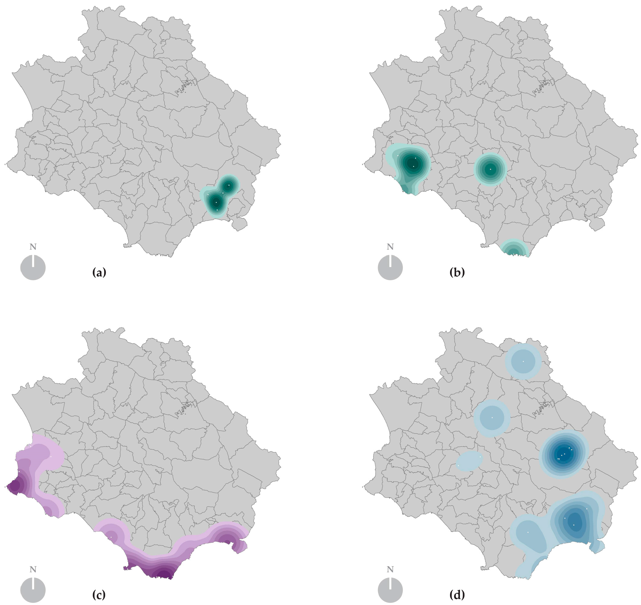
In this way, a map of suggested places was created for each interviewee, and was subsequently subjected to a Kernel Density Estimation (KDE) [73,74]. The KDE is one of the major geo-statistical techniques used in Point Pattern Analysis [75], and makes it possible to locate the areas with the highest density, considering the weight and the closeness of the points.
More specifically, the analysis was conducted by considering as radius the average distance among the distances of the mentioned locations from the interviewee’s abode (in the case of the insiders), or from the place of the interview (in the case of the outsiders). In this manner, once radiuses of different length (4 km, 6 km, 8 km, 10 km and 12 km) were found, taking into consideration the indicated locations, an area of landscape perception was traced for each interviewee.
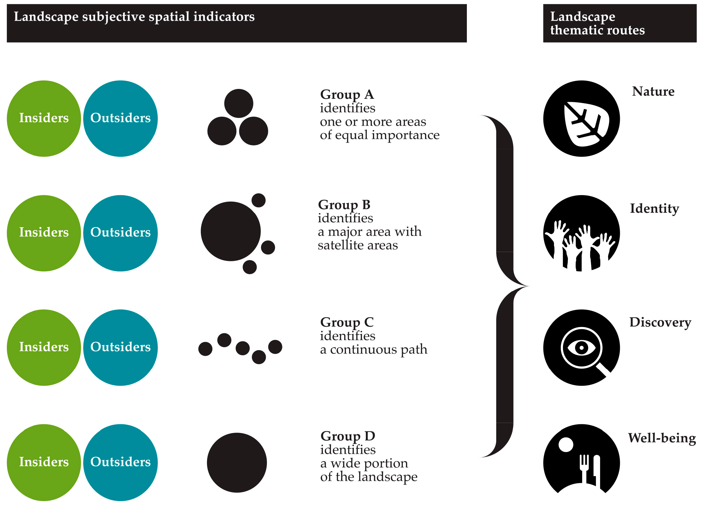
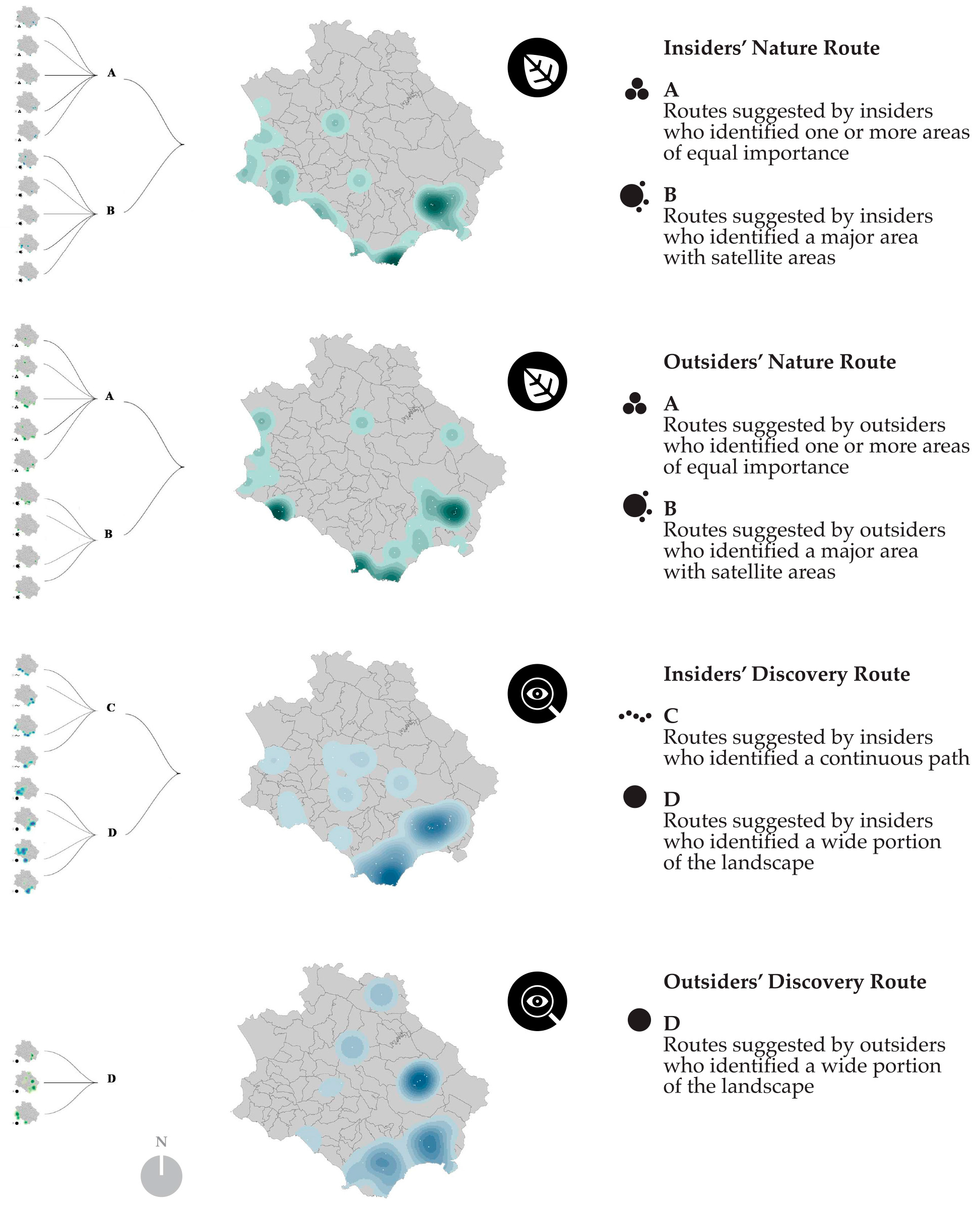
In a final comparison of the results, the KDE analysis made it possible to distinguish four different ways of perceiving the local landscape (Figure 4 and Figure 5):
- -
- Group A identifies one or more areas of equal importance;
- -
- Group B identifies a major area with satellite areas;
- -
- Group C identifies a continuous path;
- -
- Group D identifies a wide portion of the landscape.
3. Results of the Co-Evaluation Phase
Below will be shown the intermediate results, followed by the final results of the research. The first results made it possible to trace the new thematic routes, while the second results were the actual routes found in the research.
3.1. Intermediate Results
The very first result of the co-evaluation phase revealed the shared-values and their local meanings, which, in our analysis, corresponded with the topics of the touristic routes to be traced. The second result detailed the thematic maps of the places and their related weights, assigned as per the level of of importance recognized by the interviewees when indicate and describe them.
A third result was the acknowledgement of four different forms of perception of the landscape by the people interviewed, based on the radius of action (range) of their observation (Figure 4).
In addition, another result revealed the existing relations between these different forms of landscape perception and the shared values (identified with the topics of the routes), both for the insiders and for the outsiders (Figure 5). In particular:
- -
- Among the insiders, those who prefer the Nature and Identity Routes belong to Groups A and B, while those who prefer the Well-being and Discovery Routes belong to Groups C and D.
- -
- Among the outsiders, those who prefer the Nature and Well-being Route belong to Groups A and B, while those who prefer the Discovery Route belong to Group D.
Subsequently, a new Kernel Density Estimation was carried out, taking into account the radius of action of the different types of observers (Groups A–D); indeed, this enabled us to identify, for each route (Discovery, Identity, Well-being, Nature), the areas of interest or significant areas, where there is a higher concentration of indicated places. The summary maps (Figure 6) show the most significant areas within the Park for the Nature and Discovery routes, according to the insiders and outsiders. After comparing the summary routes for these diverse types of users, it was noticed that the major differences pertained not to the indicated locations, but the importance of the areas. This is mainly because insiders, unlike outsiders, give more relevance to the places and, as argued previously, perceive their environment in a shorter range and with a higher level of precision; indeed, as one would expect, lesser known places, away from the beaten tracks, were more frequently mentioned by them.
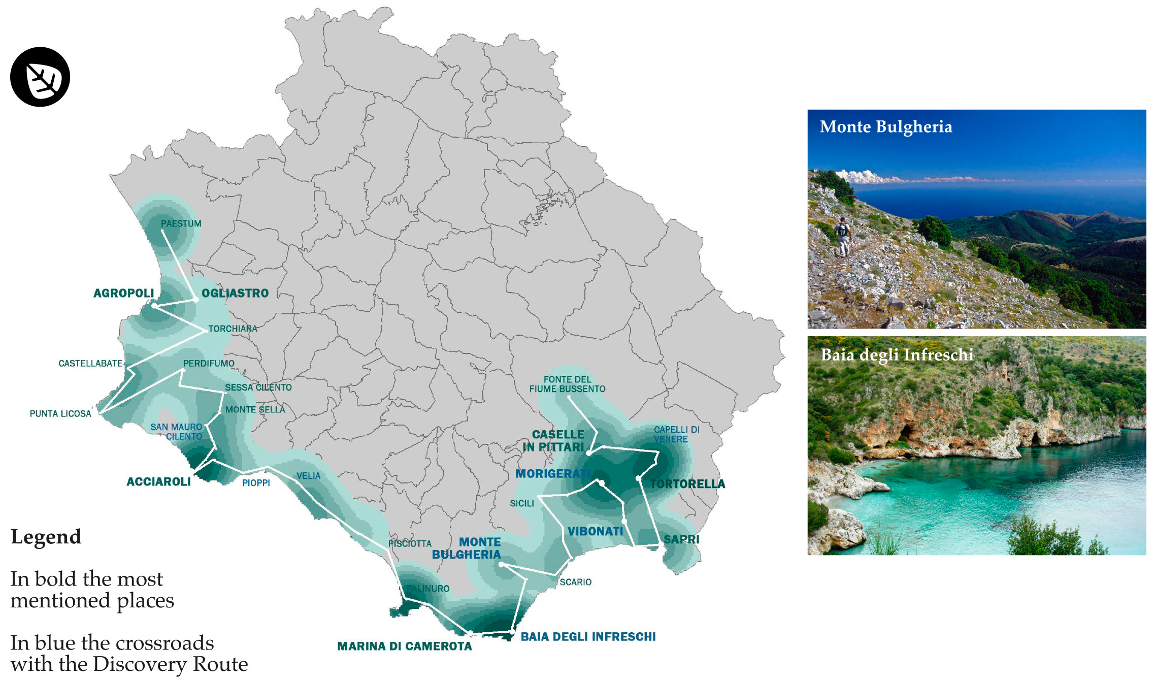
3.2. The Routes
Starting with considering the significant areas and places, both for the insiders and the outsiders, for each route, a suggested path was traced, aimed at offering visitors a particular experience of the Park (Nature, Well-Being, Discovery and Identity). As shown in Figure 7 and Figure 8, two different paths were drawn by giving prominence to the areas with a higher concentration of places of interest, recognised for each shared value (which coincides with the theme of the route).
For this reason, these areas will be the core of the proposed routes, with longer or multiple stopovers in their paths. To cite an instance, the Discovery Route shows two main areas of interest with a higher concentration of indicated locations; this is why the itinerary was mainly outlined around these areas, with 18 stopovers out of 34 in the entire path.
One last point relates to the locations that are in more than one itinerary; they lend themselves to become the crossroads among diverse thematic routes.
In conclusion, the routes and places of value drew a “new sentimental geography” [76] of the Park. The methodology developed can help the promotion of the Park by local shareholders, providing patterns to collect subjective data and understand the different forms of the individual perceptions of the landscape. This will give the promoters of the Park useful information which can be employed to form new actions and develop a deeper knowledge and awareness of local qualities and potentials.
4. Discussion and Conclusions
The construction of a Multi-Stakeholder Spatial Decision Analysis process, as designed, made it possible to develop a decision-making process to enhance the landscape and its resources internal to local realities; the ultimate aim was to identify and understand, from the different points of view of users (insiders and outsiders), what resources are worth recognising.
The perceived value of resources is explicated by indicators that expose the individual point of view and make it possible to detect and expose shared views that become the expression of shared values through spatial density maps.
The Ci.Vado lab aims to describe the landscape by using a collaborative process, starting from people’s experiences and perceptions, identifying values that are tied to the specific places and the personal relationships. Tracing users’ landscape values could be helpful for developing innovative and sustainable strategies with which to promote the Park and activate a process of innovative management. The identification of perceived values thus becomes the basis for proposing new thematic routes, and expressing shared values.
Shared values are recognisable in specific locations that describe landscape itineraries which, at the same time, can be interpreted as resource valorisation routes that constitute an integral part of the communities that live and use the Park and are, therefore, an expression of the various forms of resilience that the landscape expresses. In addition, from the shared values, it is possible to identify strategies and actions with which to enhance the landscape of the Park; indeed, such strategies and actions could increase its level of resilience, while safeguarding the intrinsic autopoietic characteristics.
The tested model started with the promotion of actions already undertaken by the community to improve the standards of living. It attempted to identify the bases for new forms of cooperative and smart management which are capable of increasing local sources’ values, where solutions are designed for a specific context and produced by the interaction between local administrations, public and private actors, researchers and the living community.
The model could serve as an instrument of knowledge and valorisation of local landscapes—an alternative to the traditional tourism promotion processes of the territories; it is attentive to resource specificities and active links that develop between insiders and outsiders.
Indeed, the preservation of the landscape values cannot only be left to the qualified institutions [17]; it is the community that has lived and built the landscape that should make a relevant contribution to resources management, which considers people as the core of a process of social innovation aimed at stimulating local development: new services arise from real people’s needs and are co-designed and co-evaluated with the citizens themselves through an interactive, dialogical and collaborative process [77,78].
The methodological framework elaborated for the co-evaluation phase constitutes a research field which is still open and which requires new instruments (dynamic, adaptive, hybrid, flexible to different contexts) to represent, monitor, and manage landscape changes.
In fact, the interpretation of values already suggests new methods of representation and overcoming the homogeneous characters in the classification to create a more complex approach.
The structured approach is aimed at finding new ways to promote the Park and its resources, where great importance is given to the recognition of the meanings assigned to the places by citizens or other kind of users, and the representation of landscape perceptions. The results revealed an evident connection between the meanings assigned and the perceived values of the landscape.
The methodology developed sets up an experiment: tracing values and meanings of attractive places from the representation of the landscape perceived by users (insiders and outsiders).
Certain relevant issues also emerged from the activation of the co-evaluation process. In the first step, the processing of soft investigations based on semantic analysis should be extended to other areas of the Park, in order to gather the preferences of a richer sample of insiders and outsiders arising from the different realities of the Park. With regard to the third step, related to the spatial representation model of the landscape perception, one of the most interesting aspects is the opportunity to identify and represent places that are not related to administrative and geographical boundaries, but are relevant because of the meanings attributed to them. In the fourth step, the relations between the places, the meanings assigned to them, and their representation through routes of places of values, contribute to elaborate maps of shared values, and the expression of multidimensional and complex landscapes, where multiple systems of values interact and could, potentially, regenerate themselves and become a catalyst for positive valorisation processes.
The most relevant results of the study relate to acknowledging the subjectivity of the objective environment, its representation in the space, and further interpretations of it.
The development of subjective indicators from structure surveys taking into account the components of the Cultural Value Model, highlights the opportunity to consider the subjective components for both the type of information they use and their evaluation.
Subjective indicators have been proven to possess predictive power for a large array of social and economic outcomes, and are often defined as information that includes a subjective component, or an expression of a personal perception or a personal evaluation [42], considered relevant to the subjective measurement. This definition includes subjective measures of objective and subjective criteria. Indeed, in our research, subjective indicators were obtained as subjective information and were defined by subjective measures of a subjective criterion.
The reliability of the obtained result derives from the comparison and integration of the indicators developed from the information gathered by interviewing outsiders and insiders. The comparison of the points of view also allowed us to test the validity of the indicators. In addition, the selection of the information collecting method based on the qualitative approach of in-depth interviews made it possible to more thoroughly explore the issues and obtain richer and more articulated information about the items in question; this also made it possible to investigate the reasons behind the explained preferences.
However, there are some problems with using subjective indicators, because they are based on personal experiences, are the result of personal desires and expectations, and, in many cases, constitute the territorial boundaries for the individual, which do not correspond with the administrative ones [45]. Furthermore, the landscape values mentioned by users (insider and outsiders) have some implications (as for touristic facilities); indeed, when these values are overlooked, this can produce effects opposite to those intended, such as the loss of appeal in the networks of local enhancement.
In addition, the spatial elaboration of the identified indicators allowed us to spatially represent perceptions and to structure a process of interpretation and evaluation capable of returning routes maps, which are an expression of a shared intersubjective perception.
From the achieved results, it is clear that the proposed methodology can support the development of local and collaborative strategies for the exploitation of local resources, especially in fragile contexts that require a sensitive and close look which can capture the specifics to value with care, and engage in sustainable processes where the environmental, economic and social dimensions are integral to a path that recognises values as an expression of cultural and identity ties between communities and places.
Because of the landscape and its values, as well as the expression of skills and forms of rooted coexistence, there is a need to develop innovative approaches to local development which affect our standard of living. The synergistic relationship and interaction between landscape and users identify a cultural perspective and combines dynamic resilience and adaptive innovation [28]; this, in turn, helps to build social cohesion and cooperative welfare. Indeed, by taking a close and careful look, it is possible to highlight specific components and interrelations, where the changes are based on the principle of subsidiarity and include plural and multidimensional points of view [46].
The landscape becomes an action research field for innovative bottom-up processes where models for landscape changes management can be developed. These models focus on people and promote the use of innovation and technology according to local conditions and citizens’ needs, defining a complex space which pays careful attention to social cohesion, creativity and quality of life, and is able to create synergies among natural, rural and urban areas; this is done using ecological networks, and enhancing various aware forms of culture. The landscape attractiveness, which involves improving the quality of spaces, uses and relationships, produces new values and increases its resilience capacity, supporting the identification of the relational values [79] and of the shared change model in local transformations. Indeed, the landscape can stand the shock and adapt itself to changes only when the local communities start a social innovation process that affects lifestyle and resource management. This research field is still open and is seeking and testing new approaches and instruments of representation, evaluating, monitoring and management for the landscape.
Acknowledgments
The study has been developed as part of the research project “Cilento Labscape: An integrated model for the Living Lab activation in the National Park of Cilento, Vallo di Diano and Alburni”, F.A.R.O. (Finanziamento per l’Avvio di Ricerche Originali) Programme. The authors would like to thank the anonymous reviewers for their valuable comments and suggestions to improve the quality of the paper.
Author Contributions
The authors jointly conceived and developed the approach and decided on the overall objective and structure of the paper; Simona Panaro elaborated and performed the analysis and the evaluations; both authors contributed to the writing of the paper and have read and approved the final version.
Conflicts of Interest
The authors declare no conflict of interest.
References
- Local Governments for Sustainability (ICLEI). Resilient Cities 2012. In Congress Report, Proceedings of the 3rd Global Forum on Urban Resilience and Adaptation, Bonn, Germany, 12–15 May 2012; ICLEI: Bonn, Germany, 2012. [Google Scholar]
- ICLEI. Resilient Cities Report 2016. In Global Developments in Urban Adaptation and Resilience, Proceedings of the 7th Global Forum on Urban Resilience and Adaptation, Bonn, Germany, 6–8 July 2016; ICLEI: Bonn, Germany, 2016. [Google Scholar]
- Holling, C.S. Resilience and stability of ecological systems. Ann. Rev. Ecol. Syst. 1973, 4, 1–23. Available online: http://www.jstor.org/stable/2096802 (accessed on 31 January 2017).
- Gunderson, L.H. Ecological Resilience. In Theory and Application. Ann. Rev. Ecol. Syst. 2000, 31, 425–439. [Google Scholar] [CrossRef]
- Walker, B.H.; Salt, D. Resilience Thinking: Sustaining Ecosystems and People in a Changing World; Island Press: Washington, DC, USA, 2006. [Google Scholar]
- Beller, E.; Robinson, A.; Grossinger, R.; Grenier, L. Landscape Resilience Framework: Operationalizing Ecological Resilience at the Landscape Scale; Prepared for Google Ecology Program. A Report of SFEI-ASC’s Resilient Landscapes Program, Publication 752; San Francisco Estuary Institute: Richmond, CA, USA, 2015. [Google Scholar]
- Costanza, R.; Waigner, L.; Folke, C.; Mäler, K.-G. Modeling complex ecological economic systems: Towards an evolutionary dynamic understanding of people and nature. BioScience 1993, 43, 345–555. [Google Scholar] [CrossRef]
- Folke, C.; Carpenter, S.; Elmqvist, T.; Gunderson, L.; Holling, C.S.; Walker, B. Resilience and Sustainable Development: Building Adaptive Capacity in a World of Transformations. Ambio 2002, 31, 437–440. [Google Scholar] [CrossRef] [PubMed]
- Folke, C.; Carpenter, S.; Walker, B.; Scheffer, M.; Chapin, T.; Rockstrom, J. Resilience thinking: Integrating resilience, adaptability and transformability. Ecol. Soc. 2010, 15, 20–28. Available online: http://www.ecologyandsociety.org/vol15/iss4/art20/ (accessed on 30 January 2017).
- Otto-Zimmermann, K. Resilient Cities. Cities and Adaptation to Climate Change. Proceedings of the Global Forum 2010; Springer: Dordrecht, The Netherlands, 2011. [Google Scholar]
- Walker, B.H.; Holling, C.S.; Carpenter, S.R.; Kinzig, A. Resilience, adaptability and transformability in social-ecological systems. Ecol. Soc. 2004, 9, 1–9. Available online: http://www.ecologyandsociety.org/vol9/iss2/art5/. (accessed on 30 January 2017).
- Pigram, J.J.; Wahab, S. Tourism, Development and Growth: The Challenge of Sustainability; Routledge: London, UK; New York, NY, USA, 1997. [Google Scholar]
- Hall, C.M.; Lew, A.A. Understanding and Managing Tourism Impacts: An Integrated Approach; Routledge: London, UK, 2009. [Google Scholar]
- Briedenhann, J.; Wickens, E. Tourism routes as a tool for the economic development of rural areas—Vibrant hope or impossible dream? Tour. Manag. 2004, 25, 71–79. [Google Scholar] [CrossRef]
- Coccossis, H.; Mexa, A. The Challenge of Tourism Carrying Capacity Assessment: Theory and Practice; Ashgate: Aldershot, UK, 2004. [Google Scholar]
- Fusco Girard, L.; Nijkamp, P. Cultural Tourism and Sustainable Local Development; Ashgate: Aldershot, UK, 2009. [Google Scholar]
- Sonkoly, G. Historical Urban Landscape; Springer: Cham, Switzerland, 2017. [Google Scholar]
- The World Trade Organization (WTO). Tourism’s Potential as A Sustainable Development Strategy; World Tourism Organization: Madrid, Spain, 2005. [Google Scholar]
- Lone, S.; Lone, F.A.; Malik, A. Carrying capacity assessment for the promotion of ecotourism in Bangus Valley: A future tourist destination of J&K-India. Int. J. Sci. Res. 2013, 2, 187–188. [Google Scholar]
- Salerno, F.; Viviano, G.; Manfredi, E.C.; Caroli, P.; Thakuri, S.; Tartari, G. Multiple carrying capacities from a management-oriented perspective to operationalize sustainable tourism in protected areas. J. Environ. Manag. 2013, 128, 116–125. [Google Scholar] [CrossRef] [PubMed]
- Bera, S.; Das Majumdar, D.; Kumar Paul, A. Estimation of Tourism Carrying Capacity for Neil Island, South Andaman, India. J. Coast. Sci. 2015, 2, 46–53. [Google Scholar]
- Malik, M.I.; Bhat, M.S. Sustainability of tourism development in Kashmir—Is paradise lost? Tour. Manag. Perspect. 2015, 16, 11–21. [Google Scholar] [CrossRef]
- Plieninger, T.; Bieling, C. Resilience and the Cultural Landscape. Understanding and Managing Change in Human-Shaped Environments; Cambridge University Press: New York, NY, USA, 2012. [Google Scholar]
- United Nations Development Programme. Communities in Action for Landscape Resilience and Sustainability—The COMDEKS Programme; UNDP: New York, NY, USA, 2014. [Google Scholar]
- Berkes, F.; Folke, C. Linking Social and Ecological Systems: Management Practices and Social Mechanisms for Building Resilience; Cambridge University Press: Cambridge, UK, 1998. [Google Scholar]
- Carpenter, S.R.; Westley, F.; Turner, G. Surrogates for resilience of social–ecological systems. Ecosystems 2005, 8, 941–944. [Google Scholar] [CrossRef]
- Simmie, J.; Martin, R. The economic resilience of regions: Towards an evolutionary approach. Camb. J. Reg. Econ. Soc. 2010, 3, 27–43. [Google Scholar] [CrossRef]
- Davoudi, S.; Shaw, K.; Jamila Haider, L.; Quinlan, A.E.; Peterson, G.D.; Wilkinson, C.; Fünfgeld, H.; McEvoy, D.; Porter, L. Resilience: A Bridging Concept or a Dead End? “Reframing” Resilience: Challenges for Planning Theory and Practice Interacting Traps: Resilience Assessment of a Pasture Management System in Northern Afghanistan Urban Resilience: What Does it Mean in Planning Practice? Resilience as a Useful Concept for Climate Change Adaptation? The Politics of Resilience for Planning: A Cautionary Note. Plan. Theory Pract. 2012, 13, 299–333. [Google Scholar]
- The United Nations Educational, Scientific and Cultural Organization (UNESCO). Recommendation on the Historic Urban Landscape; Annex: Paris, France, 2011. [Google Scholar]
- Pelling, M. Adaptation to Climate Change, from Resilience to Transformation; Routledge: London, UK; New York, NY, USA, 2010; ISBN 978 0 415 477505. [Google Scholar]
- Verde, A. Resilient Landscapes. From spontaneous adaptation to a post-industrial planned multi-scalar resilience. In Resilient Cities 2013: Congress Report, ICLEI, Proceedings of the 4th Global Forum on Urban Resilience and Adaptation, Bonn, Germany, 31 May–2 June 2013; ICLEI: Bonn, Germany, 2013; pp. 1–17. [Google Scholar]
- Van Kamp, I.; Leidelmeijer, K.; Marsman, G.; De Hollander, A. Urban environmental quality and human well-being. Towards a conceptual framework and demarcation of concepts: A literature study. Landsc. Urban Plan. 2003, 65, 5–18. [Google Scholar]
- Kenter, J.O.; Reed, M.S.; Everard, M.; Irvine, K.N.; O’Brien, E.; Molloy, C.; Bryce, R.; Brady, E.; Christie, M.; Church, A.; et al. Shared, Plural and Cultural Values: A Handbook for Decision-Makers. In UK National Ecosystem Assessment Follow-On Phase; UNEP-WCMC: Cambridge, UK, 2014. [Google Scholar]
- Kenter, J.O.; Reed, M.S.; Irvine, K.N.; O’Brien, E.; Brady, E.; Bryce, R.; Christie, M.; Church, A.; Cooper, N.; Davies, A.; et al. Shared, Plural and Cultural Values of Ecosystems. In UK National Ecosystem Assessment Follow-On Work Package Report 6; UNEP-WCMC: Cambridge, UK, 2014. [Google Scholar]
- Council of Europe. European Landscape Convention, Florence, 20.X.2000. European Treaty Series—No. 176. Available online: http://www.coe.int/en/web/conventions/full-list/-/conventions/treaty/176 (accessed on 30 January 2017).
- Council of Europe. Council of Europe Framework Convention on the Value of Cultural Heritage for Society, Faro, 27.X.2005. Council of Europe Treaty Series—No. 199. Available online: http://www.coe.int/en/web/conventions/full-list/-/conventions/treaty/199 (accessed on 30 January 2017).
- Goosen, M.; Langers, F. Assessing quality of rural areas in the Netherlands: Finding the most important indicators for recreation. Landsc. Urban Plan. 2000, 46, 241–251. [Google Scholar] [CrossRef]
- Veenhoven, V. Subjective measures of well-being. In Human Well-Being Concept and Measurement; McGillivray, M., Ed.; Palgrave/McMillan: Houndmills, NH, USA, 2007; pp. 214–239. [Google Scholar]
- Cassatella, C.; Peano, A. Landscape Indicators: Assessing and Monitoring Landscape Quality; Springer: Dordrecht, The Netherlands, 2011. [Google Scholar]
- UNU-IAS; Bioversity International; IGES; UNDP. Toolkit for the Indicators of Resilience in Socio-Ecological Production Landscapes and Seascapes (SEPLS). 2014. Available online: https://comdeksproject.files.wordpress.com/2014/11/toolkit-indicators-web.pdf (accessed on 30 January 2017).
- Lawrence, R.J. Human ecology and its applications. Landsc. Urban Plan. 2003, 65, 31–40. [Google Scholar] [CrossRef]
- Rammstedt, B. Subjective Indicators. RatSWD Work. Pap. Ser. 2009, 119, 1–10. [Google Scholar] [CrossRef]
- Organization for Economic Co-operation and Development (OECD). How's Life? 2015. Measuring Well-Being; OECD Publishing: Paris, France, 2015. [Google Scholar]
- Department of Economic and Social Affairs (DESA). The Sustainable Development Goals Report 2016; UN: New York, NY, USA, 2016. [Google Scholar]
- Pacione, M. Urban environmental quality and human wellbeing—A social geographical perspective. Landsc. Urban Plan. 2003, 65, 19–30. Available online: http://www.sciencedirect.com/science/article/pii/S0169204602002347 (accessed on 30 January 2017).
- Cerreta, M.; Fusco Girard, L. Human Smart Landscape: An Adaptive and Synergistic Approach for the “National Park of Cilento, Vallo di Diano and Alburni”. Agric. Agric. Sci. Procedia 2016, 8, 489–493. [Google Scholar] [CrossRef]
- Irvine, K.; O’Brien, L.; Ravenscroft, N.; Cooper, N.; Everard, M.; Fazey, I.; Reed, M.; Kenter, J.O. Ecosystem services and the idea of shared values. Ecosyst. Serv. 2016, 21, 184–193. [Google Scholar] [CrossRef]
- Mash, J. Living Labs and Territorial Innovation. In Collaboration and the Knowledge Economy: Issues, Applications, Case Studies; Cunningham, P., Cunningham, M., Eds.; Ios Press: Amsterdam, The Netherlands, 2008. [Google Scholar]
- Ståhlbröst, A.; Holst, M. The Living Lab Methodology Handbook; Social Informatics at Luleå University of Technology and CDT, Centre for Distance-spanning Technology: Luleå, Sweden, 2012. [Google Scholar]
- D&Auria, A.; Ruocco, F. Paesaggio, Strategia, Identità. Pianificare il Cilento tra vocazione ed innovazione. Urban. Inf. 2007, 211, 61–62. [Google Scholar]
- ENoLL—European Network of Living Labs. Available online: http://www.openlivinglabs.eu/aboutus (accessed on 30 January 2017).
- Molinari, F. Overview of the Living Lab Approach. In Best Practices Database for Living Labs; Alcotra Innovation Project: Tourin, Itay, 2011; pp. 7–48. Available online: http://www.alcotra-innovation.eu/progetto/ (accessed on 30 January 2017).
- Concilio, G. Urban Living Labs: Opportunities in and for Planning. In Human Smart Cities. Rethinking the Interplay between Design and Planning; Concilio, G., Rizzo, F., Eds.; Springer: Heidelberg, Germany, 2016; pp. 21–40. [Google Scholar]
- Stephenson, J. The Cultural Values Model: An integrated approach to values in landscapes. Landsc. Urban Plan. 2008, 84, 127–139. Available online: http://www.sciencedirect.com/science/article/pii/S0169204607001661 (accessed on 30 January 2017). [CrossRef]
- Goddard, C. Semantic Analysis. A Practical Introduction, 2nd ed.; Oxford University Press: Oxford, UK, 2011. [Google Scholar]
- MacFarlane, R.; Haggett, C.; Fuller, D.; Dunsford, H.; Carlisle, B. Tranquillity Mapping: Developing A Robust Methodology for Planning Support; Report to the Campaign to Protect Rural England, Countryside Agency, North East Assembly, Northumberland Strategic Partnership, Northumberland National Park Authority and Durham County Council, Centre for Environmental & Spatial Analysis; Northumbria University: Newcastle Upon Tyne, UK, 2004. [Google Scholar]
- Djamel, F. Valuation Methods of Landscape. Int. J. Res. Methodol. Soc. Sci. 2016, 2, 36–44. [Google Scholar]
- Rappaport, A. Creating Shareholder Value. A Guide for Managers and Investors; The Free Press: New York, NY, USA, 1986. [Google Scholar]
- Mäenpää, M. The Importance of Shareholder Value in Decision-Making. In Business Economics; Vaasan Ammattikorkeakoulu: Vaasa, Finland, 2016; pp. 1–63. [Google Scholar]
- Jansson, A.M.; Hammer, M.; Folke, C.; Costanza, R. Investing in Natural Capital: The Ecological Economics Approach to Sustainability; Island Press: Washington, DC, USA, 1994. [Google Scholar]
- Costanza, R.; de Groot, R.; Sutton, P.; Van der Ploeg, S.; Anderson, S.J.; Kubiszewski, I.; Farber, S.; Turner, R.K. Changes in the global value of ecosystem services. Glob. Environ. Chang. 2014, 26, 152–158. [Google Scholar] [CrossRef]
- Sagoff, M. Values and preferences. Ethics 1986, 96, 301–316. [Google Scholar] [CrossRef]
- Kenter, J.O.; O’Brien, L.; Hockley, N.; Ravenscroft, N.; Fazey, I.; Irvine, K.N.; Reed, M.S.; Christie, M.; Brady, E.; Bryce, R.; et al. What are shared and social values of ecosystems? Ecol. Econ. 2015, 111, 86–99. [Google Scholar] [CrossRef]
- Kashyap, V.; Sivadas, E. An exploratory examination of shared values in channel relationships. J. Bus. Res. 2012, 65, 586–593. [Google Scholar] [CrossRef]
- Bocanet, A.; Ponsiglione, C. Balancing exploration and exploitation in complex environments. VINE 2012, 42, 15–35. [Google Scholar] [CrossRef]
- Van den Brink, A.; Bruns, D.; Tobi, H.; Bell, S. Research in Landscape Architecture: Methods and Methodology; Routledge: New York, NY, USA, 2017. [Google Scholar]
- Kaymaz, I.C. Landscape Perception. In Landscape Planning; Murat Ozyavuz, M., Ed.; InTech: Rijeka, Croatia, 2012; Available online: http://www.intechopen.com/books/landscape-planning/landscapeperception (accessed on 30 January 2017).
- Sutton, R.K. Ecology of Scale in Visual Landscape Assessments. In Landscape Architecture Program: Faculty Scholarly and Creative Activity; University of Nebraska-Lincoln: Lincolin, NE, USA, 2013; p. 17. [Google Scholar]
- Quantum GIS Development Team. Quantum GIS Development Team. Quantum GIS Geographic Information System. In Open Source Geospatial Foundation Project; Quantum GIS Development Team: Grüt, Switzerland, 2014. [Google Scholar]
- Bonifazi, A.; Sannicandro, V.; Attardi, R.; Di Cugno, G.; Torre, M.C. Countryside vs. City: A User-Centered Approach to Open Spatial Indicators of Urban Sprawl. In Proceedings of the International Conference on Computational Science and Its Applications, ICCSA2016, Beijing, China, 4–7 July 2016; pp. 161–176. [Google Scholar]
- Meini, M.; Nocera, R.; Spinelli, G. L’analisi spaziale della mobilità turistica attraverso strumenti di geotagging: Un esperimento con la web community di Panoramio. Boll. dell'Associazione Ital. di Cartogr. 2013, 149, 87–101. Available online: http://hdl.handle.net/10077/9940 (accessed on 30 January 2017).
- Zanon, S.; Luciani, D. Il concorso Luoghi di valore. In Proceedings of the International Conference Landscapes of Everyday Life. Intersecting Perspectives on Research and Action, Perpignan, France, 16–18 March 2011; Available online: http://www.fbsr.it/ (accessed on 12 March 2013).
- Murgante, B.; Danese, M. Urban versus rural: The decrease of agricultural areas and the development of urban zones analyzed with spatial statistics. Int. J. Agric. Environ. Inf. Syst. (IJAEIS) 2011, 2, 16–28. [Google Scholar] [CrossRef]
- Vizzari, M. Spatial modelling of potential landscape quality. Appl. Geogr. 2011, 31, 108–118. [Google Scholar] [CrossRef]
- Cressie, N.A.C.; Wikle, C.K. Statistics for Spatio-Temporal Data; Wiley: Hoboken, NJ, USA, 2011. [Google Scholar]
- Bruno, G. Atlante Delle Emozioni. In Viaggio Tra Arte, Architettura e Cinema, 1st ed.; Mondadori: Milano, Italy, 2002. [Google Scholar]
- Panaro, S. Landscape Co-Evaluation. Approcci Valutativi Adattivi per la Cocreatività Territoriale e l’innovazione Locale. Ph.D Thesis, University of Naples Federico II, Napoli, Italy, 2015. [Google Scholar]
- De Oliveira, À.D. The Human Smart Cities Manifesto: A Global Perspective. In Human Smart Cities, 1st ed.; Concilio, G., Rizzo, F., Eds.; Springer: Cham, Switzerland, 2016; pp. 197–202. [Google Scholar]
- Sacco, P.L.; Zamagni, S. Teoria Economica e Relazioni Interpersonali; Il Mulino: Bologna, Italy, 2006. [Google Scholar]
Figure 1.
The National Park of Cilento, Vallo di Diano and Alburni (Italy): the places of Ci.Vado lab.
Figure 1.
The National Park of Cilento, Vallo di Diano and Alburni (Italy): the places of Ci.Vado lab.

Figure 2.
Multi-Stakeholder Spatial Decision Analysis (M-SSDA) framework.
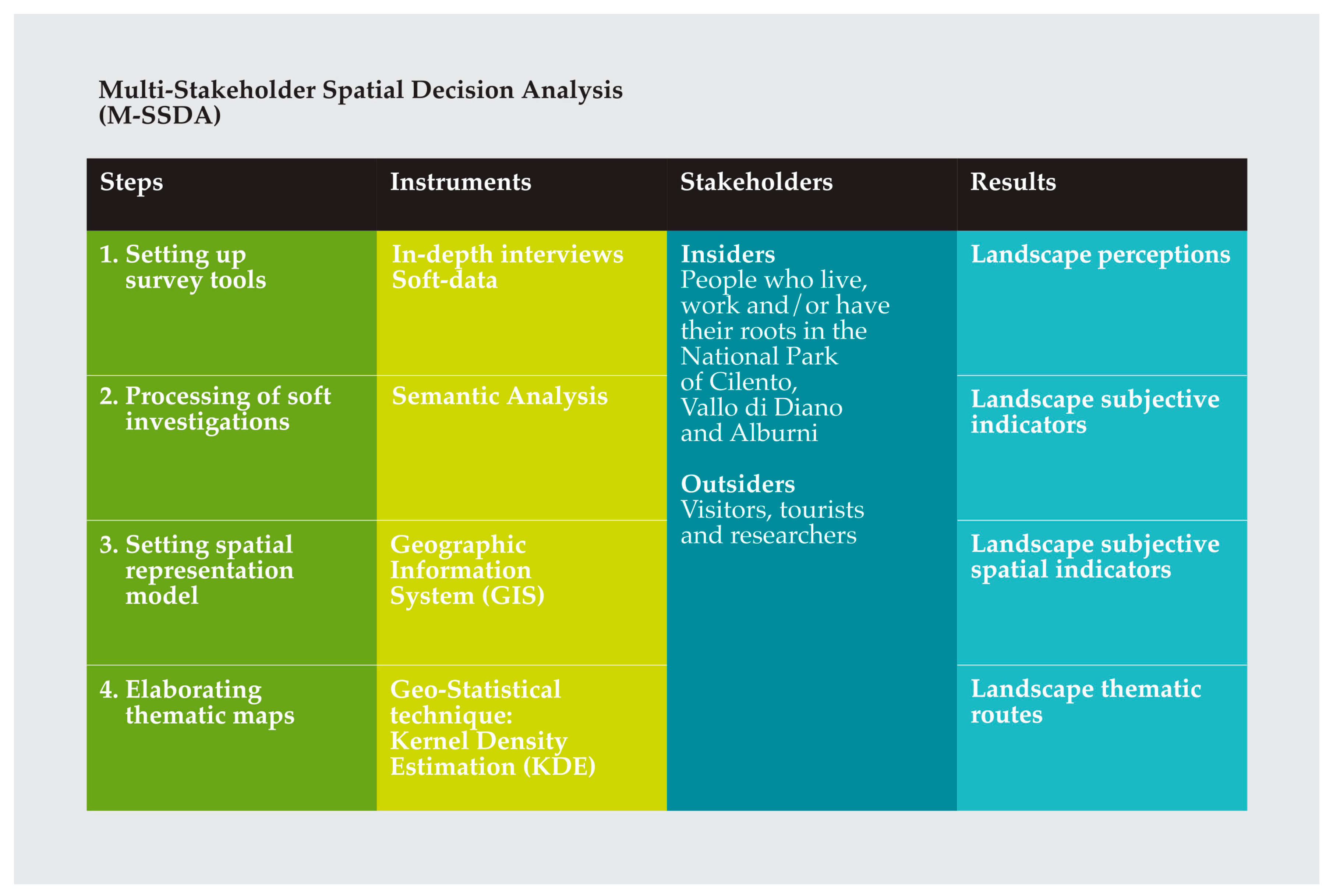
Figure 3.
Landscape values in the Cultural Values Model framework.

Figure 4.
Insiders’/Outsiders’ perceptions: (a) an example of an insider belonging to Group A; (b) an example of an insider belonging to Group B; (c) an example of an insider belonging to Group C; and (d) an example of an outsider belonging to Group D.
Figure 4.
Insiders’/Outsiders’ perceptions: (a) an example of an insider belonging to Group A; (b) an example of an insider belonging to Group B; (c) an example of an insider belonging to Group C; and (d) an example of an outsider belonging to Group D.

Figure 5.
Classification of insiders’ and outsiders’ thematic routes.

Figure 6.
Insiders’ route and outsiders’ route.

Figure 7.
Discovery Route.

Figure 8.
Nature Route.


Table 1.
Survey questions and output.
| Questions | Detected Data | Aims | Outputs |
|---|---|---|---|
| 1. What is important for you in this landscape? Why? | Key-words | Identifying the relevant tangible and intangible features of the Park landscape | Shared meanings and values of the landscape |
| 2. Which feelings do you link to these features? | Linked-words | Identifying the subjective meanings recognized to the features of the Park landscape | |
| 3. In which places within the Park do you find them? | Names of the places | Localizing the found features in the Park | Perceived qualities maps of the landscape |
| 4. Are they important places for your life? Or for your community? Why? | Relevance of the places | Attributing a weight to the places of the Park | |
| 5. Would you recommend visiting them? Why? | |||
| 6. Is there any route that you would suggest? To who? | Preferences for potential users | Identifying a specific route of the Park and its potentials users | Information for the landscape promotion |
| 7. When would be the best time to visit the Park? | Identifying a specific time to visit the Park suitable for users | ||
| 8. Could you find a motto to sum up your way of living and to promote the Park? | Identifying a way to communicate the Park and its opportunities |
Table 2.
Results of Semantic Analysis.
| Semantic Field | Key-Words | Linked-Words |
|---|---|---|
| Discovery | Known | Culture |
| Hidden | Historic town | |
| In extinction | Towns in state of abandon | |
| Not well-known | Heritage | |
| Submerged | Water | |
| Subsoil | ||
| Local food | ||
| Local crafts and knowledge | ||
| Encounter | ||
| Landscape | ||
| Traditional holiday | ||
| Identity | Community relations | Landscape |
| Hospitality | ||
| Food | ||
| Well-being | Quality of life | Traditions |
| Tranquillity | Gastronomy | |
| Healthy life | Relaxation | |
| No crime | Sea | |
| Peaceful life | Hospitality | |
| Well-being | Landscape | |
| Involvement | Culture | |
| Find oneself | ||
| Recover the meaning of life | ||
| Recover your dreams | ||
| Peace within | ||
| Freedom | ||
| Nature | Nature | Uniqueness |
| Pristine | Natural oasis |
© 2017 by the authors. Licensee MDPI, Basel, Switzerland. This article is an open access article distributed under the terms and conditions of the Creative Commons Attribution (CC BY) license (http://creativecommons.org/licenses/by/4.0/).
Share and Cite
MDPI and ACS Style
Cerreta, M.; Panaro, S. From Perceived Values to Shared Values: A Multi-Stakeholder Spatial Decision Analysis (M-SSDA) for Resilient Landscapes. Sustainability 2017, 9, 1113. https://doi.org/10.3390/su9071113
AMA Style
Cerreta M, Panaro S. From Perceived Values to Shared Values: A Multi-Stakeholder Spatial Decision Analysis (M-SSDA) for Resilient Landscapes. Sustainability. 2017; 9(7):1113. https://doi.org/10.3390/su9071113
Chicago/Turabian StyleCerreta, Maria, and Simona Panaro. 2017. "From Perceived Values to Shared Values: A Multi-Stakeholder Spatial Decision Analysis (M-SSDA) for Resilient Landscapes" Sustainability 9, no. 7: 1113. https://doi.org/10.3390/su9071113
Note that from the first issue of 2016, this journal uses article numbers instead of page numbers. See further details here.