Ancient Irrigation Canals Mapped from Corona Imageries and Their Implications in Juyan Oasis along the Silk Road


1
School of Geography and Tourism, Shaanxi Normal University, Xi’an 710062, China
2
Northwest Institute of Eco-Environment and Resources, Chinese Academy of Sciences, Lanzhou 730000, China
3
CAS Center for Excellence in Tibetan Plateau Earth Sciences, Chinese Academy of Sciences, Beijing 100101, China
4
Institute of Remote Sensing and Digital Earth, Chinese Academy of Sciences, Beijing 100094, China
*
Author to whom correspondence should be addressed.
Sustainability 2017, 9(7), 1283; https://doi.org/10.3390/su9071283
Submission received: 30 May 2017
/
Revised: 7 July 2017
/
Accepted: 18 July 2017
/
Published: 23 July 2017
(This article belongs to the Special Issue Advanced Technology for Sustainable Development in Arid and Semi-Arid Regions)
Abstract
:Historical records and archaeological discoveries have shown that prosperous agricultural activities developed in the ancient Juyan Oasis of northwestern China, an important oasis that once flourished on the ancient Silk Road. However, how the irrigation canals were distributed in historical time was unknown. Here, we identified and mapped the spatial distribution of ancient abandoned irrigation canals that were built using CORONA photographs and field inspections. This work found that ancient irrigation canals are large-scale and distributed throughout the desertified environment, with three hierarchical organization of first-, second-, and third-order irrigation canals (the total length of the first- and second-order-irrigation canals is dramatically more than 392 km). This study further indicates that ancient irrigation methods and modern irrigation systems in arid regions of China share the same basic irrigation design. New visual and fine-scale evidence and spatial distribution of irrigation canals are provided to illustrate the development of the ancient irrigated agriculture that occurred in the Juyan Oasis. This work is useful for readers who are interested in the construction and organization approaches of irrigation canals used in ancient irrigated agriculture in arid regions. It also has implications for how ancient people balance the relationships between human needs and the eco-environment using reasonable water management methods, especially for decision-making in the efficient usage of limited water resources in the arid inland river basin.
1. Introduction
Changes in irrigation canals play a significant role in the development of agricultural activities in arid regions in which water resources are delivered primarily from rivers through the construction of various artificial water conservancy facilities. As one of the main features and symbols of agricultural development in arid regions, artificial irrigation canals can be considered as the most important water conservancy facilities for irrigated agriculture. Previous studies implied that irrigation action has a long-term history in different arid regions throughout the world: the ancient agricultural irrigation systems in the Ein Gedi oasis of southeastern Israel during the Roman-Byzantine period (1st–6st centuries CE) [1]; the prehistoric irrigation canal system in North Coastal Peru during the Middle Sican (AD 900-1100) [2]; the irrigation canals in the upper Khuzestan plains of southwest Iran during the early 1st millennium CE [3]; the irrigation canals around the ancient Loulan kingdom during the Chinese Han Dynasty to the Former Liang Dynasty (202 BC-330 AD) [4]; the Zhengguo canal of the Qin State [5]; and the irrigated water management in the late Bronze Age China [6]. However, there are few studies about the spatial distribution of the ancient irrigation canals, which are important for understanding the organization of past irrigation systems and the agricultural distribution and for studying the regional environmental changes in arid areas [7,8]. As a non-destructive approach to uncover past human remains, remote sensing has been demonstrated as available for conducting archaeological applications [9]. Different, ever-more sophisticated techniques have been used to discern, extract, and analyze various archaeological remains and their surroundings by many archaeologists [1,10,11,12,13]. Among many kinds of remotely sensed data, declassified CORONA photographs have become readily available and affordable to archaeologists, which have many distinctive advantages, such as inexpensive, easily accessible, high spatial resolution and earliest imaging. CORONA imageries have been widely exploited in a variety of archaeological studies in different regions [14,15,16]. In view of its major positive sides, this kind of remote sensing data will play a more important role in archaeological research in future. However, only a few examples exist to date for the use of CORONA images in Chinese archaeology, and non-archaeological applications deal with ancient irrigation canals abandoned in arid desertified environments in China [17]. It would contribute to our understanding of historical irrigation systems by analyzing the early inexpensive CORONA images with high-resolution. On the one hand, we can obtain the spatial patterns of the irrigation canals and understand the appearance of most of the canals. On the other hand, the spatial distribution of the irrigation canals can be used to imply the environmental condition during historical periods.
Downstream environments of the arid inland river basins in northwestern China have undergone dramatic changes during the past 2000 years, particularly in regard to the severe desertification of the oasis [4,18,19,20]. In ancient times, the water demand was mainly used for agricultural activities because of a relatively small population, and the agriculture water usage was majorly supplied by Heihe River due to extremely precipitation. The artificial irrigation system was the primary technique ancient people used to deliver river water to farmlands. Certain historical literature suggests that the agricultural irrigation activities were flourishing in the lower reaches of the Heihe River Basin of northwestern China prior to the Hongwu’s Reign in the Chinese Ming Dynasty (AD 1368–1644) [21,22]. Previous work addressing ancient agricultural irrigation activities has been conducted in the downstream oasis of the Heihe River [23,24,25]. However, most of these discussions have focused on descriptive information with respect to the irrigated agriculture, and little is understood of how ancient irrigation canals were distributed and how irrigation systems were organized and displayed. Although arguments have continued for many years, the spatial distribution of ancient irrigation canals is unclear, and no studies have examined this issue using fine-scale distribution. The main purpose of this study is to present new historical data of the spatial distribution of ancient irrigation canals that was produced through remote sensing images in the arid desert region. The results are essential to understanding the development of ancient irrigated agriculture and have implications for decision-making in the efficient usage of limited water resources in the arid inland river basin [26,27]. This work also has implications for our understanding of how ancient people used reasonable water management approaches, which is essential to sustainable and efficient development in river basins, to balance the relationships between human needs and the eco-environment.
2. Study Area and History Background
The Heihe River Basin, located on the ancient Silk Road in the arid inland region of northwestern China, can be divided into three fields: the upper reaches is the water sources that originate from the Qilian Mountains in the northern portion of the Qinghai-Tibetan Plateau; the middle zone flows across the Zhangye Basin of Gansu Province; and the lower reaches that enter the Ejin Banner of Inner Mongolia (Figure 1a). The vast Gobi desert is the dominant landscape in the downstream basin, although a certain oasis is distributed along the riversides and the tail parts of this river. According to the in-situ observations, the lower reaches of the basin are currently a hyper-arid region with a mean annual precipitation of 35 mm and a potential evapotranspiration of 3755 mm (1961–2015). Consequently, it is impossible for water to accumulate as either groundwater or in rivers. Therefore, the water from the upper reaches of the basin provides an essential source of drinking water and irrigating needs for people living in the downstream regions. However, seasonal water shortage constitutes the current runoff into the lower reaches due to an extreme increase in the irrigation area of farmland in the middle zone of the basin since the latter part of the 19th century [28,29]. The downstream oases of this river are mainly composed of two parts with different locations: the modern Ejin Oasis and the ancient Juyan Oasis. The Ejin Oasis is the terminal oasis of the modern river, which is the main place that supports civilization and production in the Ejin Banner, while the ancient Juyan Oasis is located southeast of the modern Ejin Oasis and northwest of the Badain Jaran Desert (and this oasis is the study area of this research (Figure 1b)).
In the historical period, the downstream portion of the Heihe River was known as the Ruoshui, and this region of the lower reaches was referred to as the Juyan, a name given by the Hun nomadic tribes that means “lush vegetation and ample water, suitable for livestock breeding”. Historical documents clearly recorded that the ancient agricultural activities of the Juyan Oasis can be traced back to the Chinese Western Han Dynasty (202 BC-AD 8) [22]. Most detailed records of past human cultivation in this oasis come from wooden tablets and papery manuscripts that were found in ruined sites throughout the oasis [21,22,24]. The ancient Juyan was once an important point for the dissemination and promotion of cultural exchanges from different sources and was one of the essential crossing points of the ancient Silk Road [30]. Agricultural activities in this area flourished when this location was an important frontier defense location at different historical periods. The information about the past crops that were grown in the project area during different historical periods were obtained from the wooden tablets and papery manuscripts that were excavated in previous archaeological surveys, e.g., wheat, potato, bean, and fruits. However, nowadays, numerous nebkhas and sand dunes are the dominant landscapes in this oasis [20,31,32,33]. Additionally, field archaeological surveys have been conducted at the oasis since the 1900s. In the same sand where oasis civilization once flourished, a large number of archaeological remains that reflect past human activities have been discovered, including ancient town sites, fire beacon towers, temples, pagodas, residential sites, and abandoned farming fields. Furthermore, some studies about the paleo-environment in this area have been conducted in recent years, and the reconstructed data from this research can be used to discuss the relationship between human activities and nature, such as the desertification process, chronological dating, and ancient agricultural activities [20,24,25,31,32,33,34]. Nevertheless, it is difficult to obtain the spatial distribution of the ancient irrigation canals with traditional archaeological survey methods due to the severe desertified environment of the oasis. Remote sensing imagery performs effectively due to its distinctive advantages.
3. Materials and Methods
3.1. Remote Sensing Data and Image Processing
Recently, CORONA satellite data which combines high resolution and legibility of traditional aerial photographs with greater coverage of satellite imagery has become available. As the first space satellite reconnaissance program, CORONA was deployed in 1958. From 1960 to 1972, a large number of clear images with different resolutions were obtained using a photographic camera with different KH (KeyHole) codes. These images, which were not declassified until 1996 due to confidentiality, have been employed to be important data sources for conducting archaeological studies. The camera, which was equipped with KH-4A, obtained early high-resolution images at a resolution of approximately 3.0 m for the covered parts of China from August 1963 to September 1969. CORONA images served as the earliest important satellite data source in this study, as they preserved the landscape of the late 1960’s and early 1970’s, a time at the very beginning of the expansion of cultivation and intensive agricultural activities in the Heihe River Basin. The CORONA images from 29 September 1969 were ordered and acquired from the USGS for the study and were primarily used to identify most of the irrigation canals.
Geoeye images are very high resolution (VHR) satellite data, and they were obtained from Google Earth, which is a virtual global map service that contains several types of satellite images with different spatial resolutions. Google Earth is now widely used in the field of archaeological research [35,36]. In the current study, Geoeye images from Google Earth for the study area have a resolution of 0.5 m, and the acquisition dates were 28 March 2010 and 28 April 2010. As supplementary data, these images were primarily used to discern the locations of the relatively tiny irrigation canals and validate the results recognized from CORONA.
Image preprocessing was required for these images to preserve maximum details. High resolution and covering large areas resulted in some geometric distortions of these CORONA images. The two-dimensional polynomial method of geometric correction was used to correct the spatial distortions for the CORONA imageries. Geometric corrections of the images were carried out using ground control points (GCPs) from the field investigations. 36 points were used during the correction, and the GCPs include important archaeological sites and obvious targets (e.g., crossing points of rivers or canals). Next, the mosaicked data from the CORONA imageries were obtained using image processing software that applied the multi-scene images. The images used for this study were clipped with the boundary of the study area. Image enhancement was the last operation executed in order to improve the visibility of the archaeological features of the satellite data. Standard deviations and histogram equalizations were calculated for the CORONA images to highlight the artificial canals.
3.2. Field Investigation
Field investigations were conducted in August 2010 and May 2012. Certain methods for selecting the sample canal points were carefully analyzed and developed prior to the fieldwork through Google Earth. The following selection principles were applied: well-preserved canals (according to the typical linear and texture features in VHR images and previous literature [25]); remains with canal-like features; canals surrounded by nebkhas and sand dunes; canal-like structures with linear features; and farmland-like areas and points of paleochannels. These sites, i.e., artificial canals, paleochannels, abandoned farming fields, and ancient town sites, were visually surveyed during the fieldwork, and their geometries were measured, positioned, and recorded. Obtaining the ground features of the canals and the ground-truth validation data of the indoor interpreted results from the remotely sensed data were the major objectives during the field inspections. For each sampling canal point, the shape was recorded by taking photos and the coordinates were positioned by GPS (the width and depth were measured for these canals with good shapes by handed rules). Besides, collecting other archaeological remains was another purpose of the field work, which was closely related to ancient irrigated agricultural activities, including surface artifacts and other archaeological remains.
3.3. Interpretation of Canal Features
Most of the ancient irrigation canals are surrounded or separated by numerous nebkhas and sand dunes in the desert. Distinguishing and extracting these structures from a single source is difficult. In this study, remote sensing data and field inspections were combined to extract these abandoned irrigation canals, and an attempt was made to reconstruct the spatial distributions. Comparing the remote sensing images with the in-situ truths, we established the interpretation standards of ancient irrigation canals, and then identified the canals according to the image features (e.g., linear, texture, shape, width, and shadow) of the irrigation canals using remotely sensed data. In the remotely sensed images, the most obvious objects in the ancient Juyan Oasis are the irrigation canals with linear features (Figure 2). The color of these canals is white or light cyan in the VHR images, and they display as white or light black in the CORONA images. The textures are shown obviously in the images, especially for relatively wide canals. According to the careful field inspections of the construction materials and the canal surroundings, most of the artificial irrigation canals in the study area were built from clayey soil with solid and rammed earth. The artificial canals commonly appear as a groove above the rammed earth layer at a certain distance from the ground surface, and the canal shores were constructed of rammed earth of a certain width. The construction methods and the serious aeolian erosion of the surroundings might be the two reasons for the higher elevation of the canals compared to the ground surface. The current height of the remaining canals is approximately 0.1–0.8 m according to the measurements during the fieldwork.
However, it is impossible to completely reconstruct the original shapes of these almost ancient irrigation canals in such a severe desertification environment. First, most canals were artificially constructed using raw materials with a rammed-earth layer and were easily damaged after long use or abandonment, as well as severe wind erosion and desertification effects, over many years. Thus, the remaining ruins of certain canals are unclear and cannot be identified in the remote sensing images. Subsequently, most canals have been cut into various segments by numerous nebkhas and sand dunes, and it is impossible to distinguish those canal segments that are buried in the nebkhas and sand dunes. Then, the remaining canal segments that are exposed to sight were connected into an integral canal according to their surroundings and relationships. In-situ inspections of the irrigation canals were obtained during the fieldwork. Certain sample canal points that were surveyed carefully during the field investigations were used to validate the canal results that were interpreted from the images. After comparing and analyzing different canals, we have selected some image features of the typical irrigation canals (Figure 3), which are the primary and direct evidence to identify the irrigation canals from remote sensing imageries.
4. Results
4.1. Spatial Distribution of Ancient Irrigation Canals
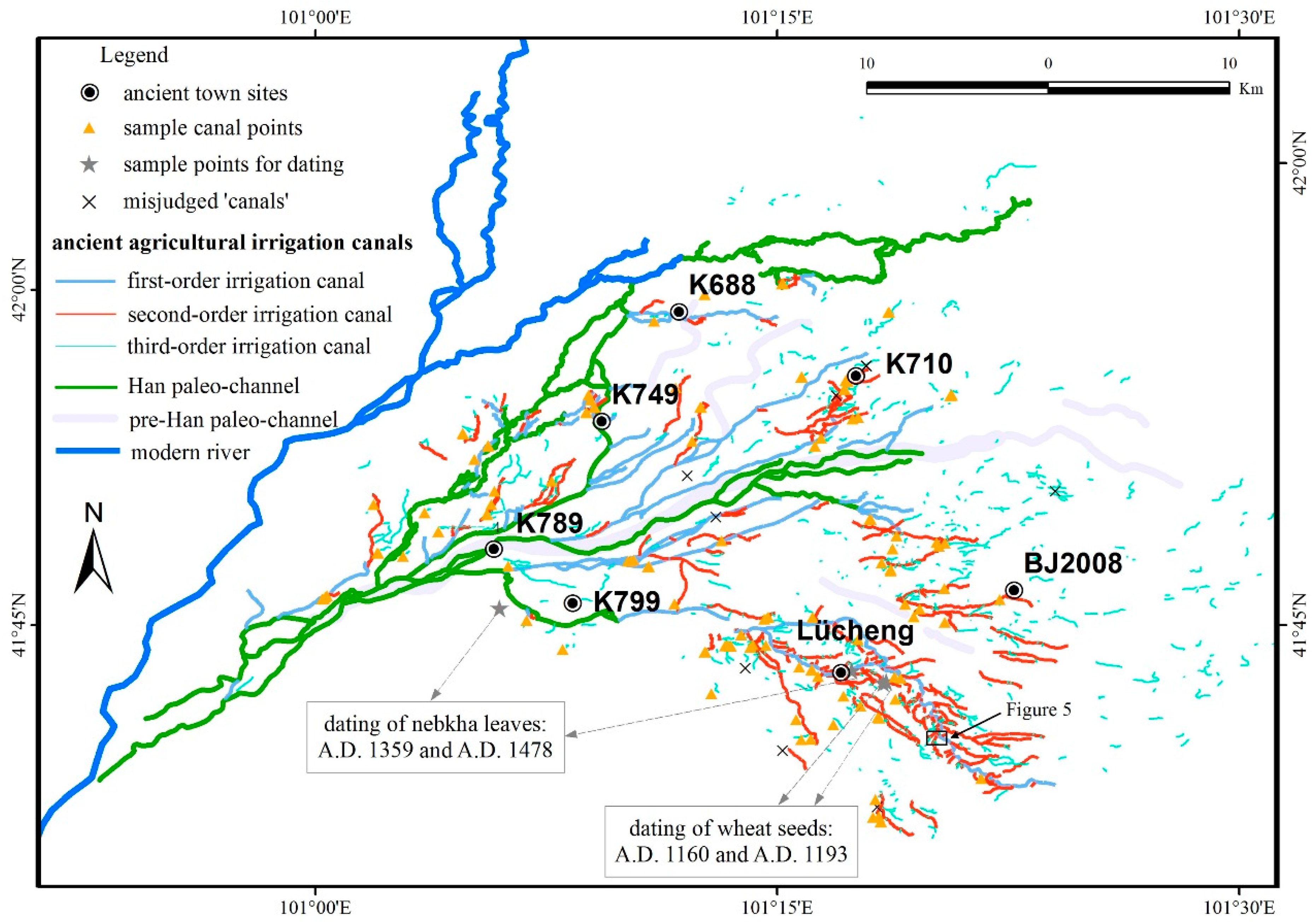
According to the above-mentioned methodologies, a spatial distribution map of the ancient irrigation canals was built in ArcGIS by digital drawing with poly-line features (Figure 4).
The study area can be divided into two regions by the Pre-Han paleochannel distributed in the middle of this oasis, which was the main channel to flow river water into the ancient Juyanze Lake before the Chinese Han Dynasty (before B.C. 202) [25]. According to the spatial distribution of ancient irrigation canals that is shown in Figure 4, the past agricultural irrigation network is distributed on a large scale throughout the ancient oasis. Most of the canals in the northern region are not continuously connected in a single system because of the severe damage of the remaining canals, which primarily consist of intermittent segments. Although most of the canals in the southern region of the oasis can be connected because the entire irrigation system for the remaining canals is in good condition, a subset of these canals are also discontinuous. There are two possible explanations for this difference in the canal appearance between the northern and southern regions of the oasis. On the one hand, the northwest wind is prevalent in the ancient Juyan Oasis [32], which could cause more significant damage to the artificial irrigation canals of the northern region that the canals in the frontier areas were wind-eroded by first. On another hand, changes in the location of human activities at different stages throughout history may have affected the continuity of the irrigation system. Historical documents and archaeological data show that human activities were primarily located in the northern areas during the Han Dynasty (202 BC-AD 220), and this period was the first intensification of agriculture in this oasis, approximately 2000 years ago [30,37]. After that time, most of the southern parts became important areas for human activities in the Western Xia Dynasty (AD 1038–1227) and Yuan Dynasty (AD 1206–1368) less than 1000 years ago. During these periods, many of the farmlands and irrigation canals were abandoned, rebuilt, and reused. After the abandonment of the northern area, the Western Xia Dynasty heralded the expansion of agriculture in the oasis. Furthermore, following the Western Xia Dynasty, there was a continuous expansion of agriculture in the Yuan Dynasty. Differences in time and space may be the major reasons for the differences in the current remaining conditions of the northern and southern irrigation canals in the study area.
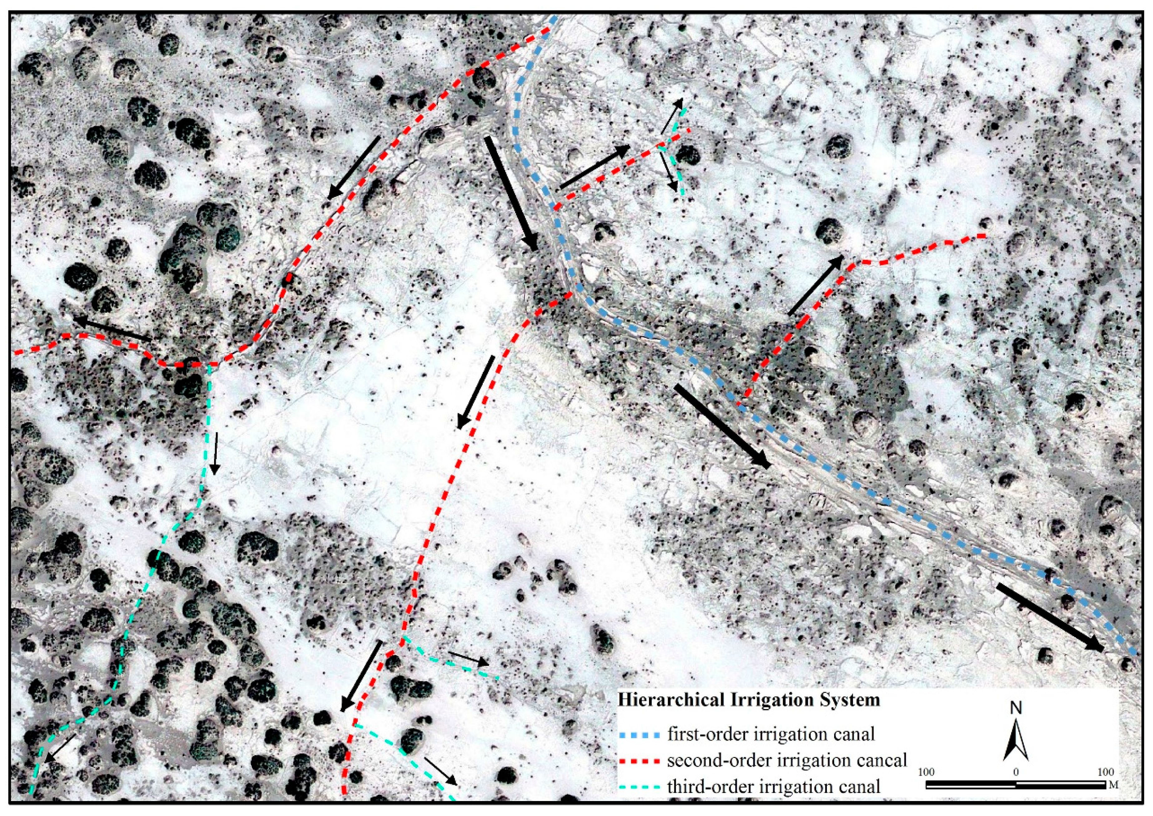
4.2. Organization of the Ancient Irrigation System
The irrigation systems can be characterized in terms of the shape, size, and hydrological position of the canals. Based on the hydrological positions and the relationships among different canals, the canals in the ancient Juyan Oasis represent hierarchical irrigation systems with first-, second-, and third-order irrigation canals (Figure 5). First-order irrigation canals were the widest artificial canals in the irrigation systems, and their hydrological role in the system was the most important to developing agriculture. The widest width of the first-order irrigation canal is about 9.0 m. The principle role of the second-order irrigation canals was to distribute water from the first-order irrigation canals to the surroundings of the ancient town sites. These secondary canals were always used as bridges between the first- and third-order irrigation canals and played a key role in the irrigation network of the agricultural oasis. The construction and distribution of the second-order irrigation canals directly affected the complexity and connectivity of the entire irrigation system. As shown in Figure 4, the distribution of second-order irrigation canals in the study area is very complex, and the total length of these second-order canals is more than 222 km. Particularly for those second-order irrigation canals distributed around the ancient Lvcheng site, they could display the connectivity of the entire irrigation system due to their good current conditions in the study area. According to the field measurements, the width of most of the second-order irrigation canal is between 3.5 and 7.0 m. Third-order irrigation canals usually acted as ‘feeder’ canals that separated blocks of farmland. Most third-order canals branched off from the secondary canals, although a subset were connected to the first-order irrigation canals. Third-order irrigation canals were the narrowest and shallowest in the entire irrigation systems, and the width of most of the third-order irrigation canals was less than 3.0 m.
Generally, the irrigation method can be generalized as the transport of water from natural river channels to blocks of farmland through different levels of artificial canals. Organization of the irrigation system (i.e., river water to first-order irrigation canal to second-order irrigation canal to third-order irrigation canal to blocks of farmland) in the study area was similar to that of modern irrigation systems (i.e., river water to trunk canal to branch canal to lateral canal to field canal to farm canal to blocks of farmland) used in irrigated agricultural districts of the arid regions of China [38]. The construction methods represent the greatest differences between the ancient and modern canals. In historical period, almost all of the canals in the study area were built above the ground surface, whereas ditches are dug and repaired as a type of irrigation canal located below the ground surface in the arid region of China in modern irrigation systems. Plentiful in-truth inspections of the irrigation canals suggest that the canals in the ancient Juyan Oasis were likely constructed above the ground surface.
4.3. The Age of Canals
This paper is focused on the identification of the ancient irrigation canals from remote sensing data and the reconstruction of the spatial distribution of ancient irrigation systems. Although historical records and archaeological data suggest that most of these irrigation canals were built and used in the Han Dynasty, the Western Xia Dynasty, and the Yuan Dynasty [24,39,40], the absolute dates on which each canal was constructed, used, abandoned, reused, and ultimately abandoned were not considered. Several research studies that applied 14C dating of wheat seeds and nebkhas’ leaves in the oasis have been conducted, and certain sampling points are shown in Figure 4. These studies indicated that most of the irrigation canals distributed in the southern region of this oasis were used in the Western Xia and Yuan Dynasties (AD 1038–1368) and abandoned after the Ming Dynasty (AD 1368–1644) [23,31,38]. Additionally, human settlement is highly dependent on irrigation activities in arid regions, and their respective developments are always contemporary. According to the constructive ages and spatial distribution of the archaeological sites in different dynasties [8], most of the irrigation canals distributed in the northern oasis are believed to have been constructed and used during the Han Dynasty (202 BC–AD 220). Due to the large-scale irrigation systems and their complex use in different times throughout history, additional dating information on the canals is needed in future studies.
5. Discussion
5.1. Implications of the Irrigation Canals
Remotely-sensed images reveal that the spatial distribution of the ancient irrigation canals is quite large, and the discovered canals are distributed throughout most of the study area. All of the ancient town sites and nearby farmlands contained irrigation canals for transporting water. Ancient irrigation canals are much narrower than natural river channels, and the width of most canals was approximately 1.5–9.0 m, which was measured during the fieldwork. The length of the canals varied in different hierarchical irrigation canals: the longest canal belonged to the first-order category, with a length greater than 21 km, whereas the shortest canal was only several meters for certain third-order irrigation canals. According to calculations by GIS software, the cumulative length of all the first-order canals is up to 170 km and that of all the second-order canals is more than 222 km. The cumulative length of the former second-order irrigation canals suggests that the scale of irrigated farmland in the study area during the historical period was rather large. Although incomplete, previous studies show that the total area of the ancient farmland was estimated at greater than 4.0 × 10⁴ ha, according to remote sensing images, archaeological remains, and field investigations [8,31]. All of the above evidence suggests that the irrigation techniques of the study area were well developed during historical times. The huge scale of the ancient irrigation system also suggests that the water flow in the downstream of the Heihe River Basin was plentiful enough to support the development of irrigated agriculture in the historical period. In fact, certain studies have also found that there was sufficient river water entering the ancient Juyan Oasis before the Hongwu’s Reign of the Ming Dynasty to support large-scale agricultural development, using dating and estimation methodologies [29,32,33,34,41].
Ancient people understood the principles of gravity and possessed the technological ability to divert river water to the farming areas to irrigate farmlands, where irrigated agriculture developed in the river surroundings [1]. Our reconstruction of the past irrigation canals also implies that ancient people had the ability and techniques to transport river water into the farming areas to develop irrigated agriculture in the ancient Juyan Oasis during historical periods. Furthermore, the hierarchical irrigation systems also suggested that an efficient irrigation method had been used to deliver river water into the farmlands in the study area in the historical period. The ancient irrigation system plays a certain stimulating role in the developing process of the local irrigation activities, including the canal construction styles, the hierarchical organization, and the large-scale dense irrigation project. This knowledge is also potentially valuable to water resources management and usage in the Heihe River Basin, where rapid population increases and extensive expansion of the irrigation area in this drainage region make efficient water management essential. To optimize the utilization of water resources, the construction of irrigation canals should be harder and involve less infiltration, and the organization of the irrigation systems should be more reasonable and efficient. Certain experiences and advice could be gleaned from the irrigation canals and the system that was distinguished and reconstructed in this work, which was developed and used in the historical period. In summary, an efficient irrigation system could be beneficial to the overall conservation and use of limited water resources in arid river basins.
5.2. Validation and Uncertainties
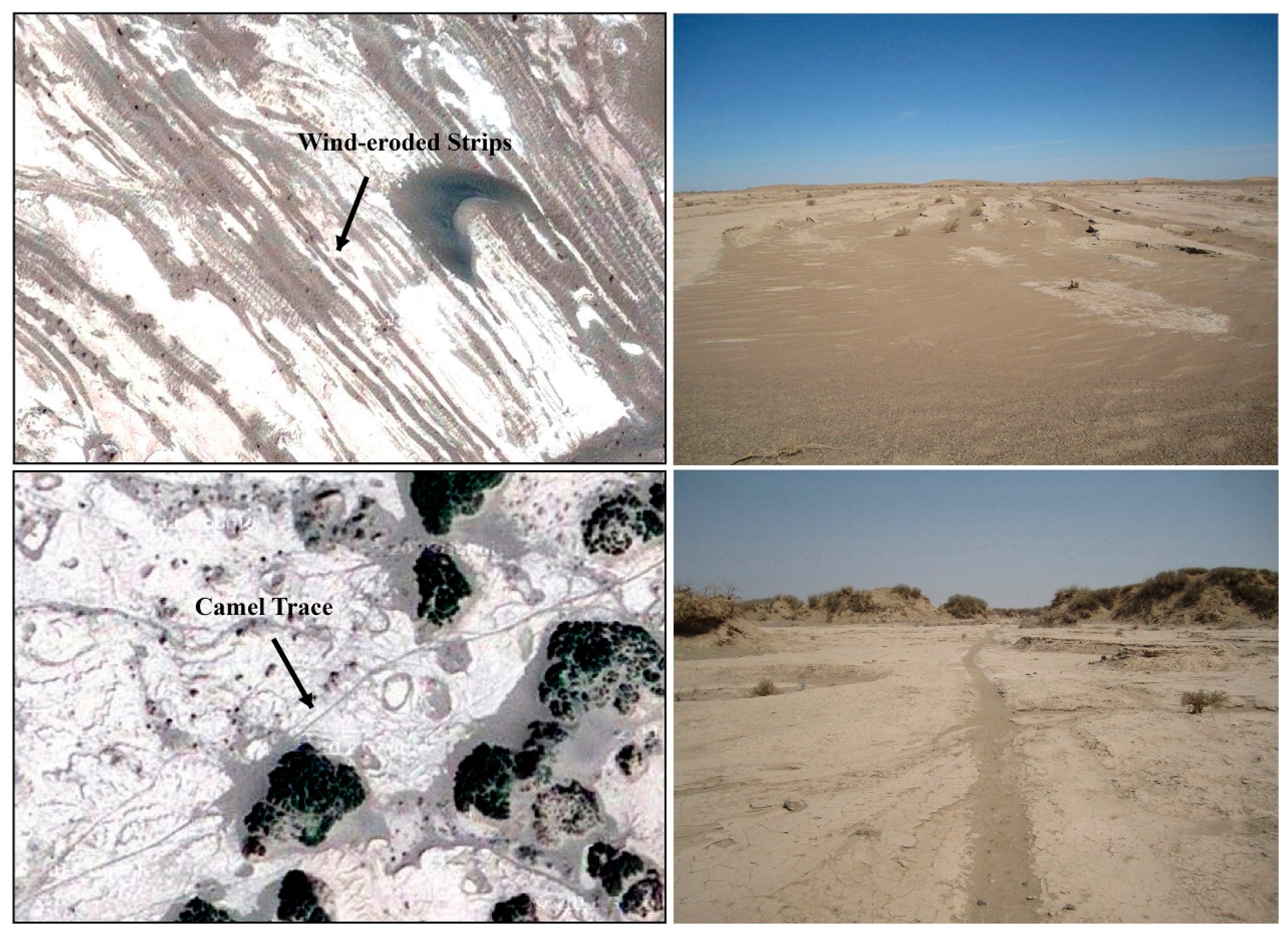
The ancient Juyan Oasis has undergone desertification under the influence of natural factors and human activities [18,31,32,33,37]. Most of the ancient irrigation canals are surrounded or separated by nebkhas and sand dunes. Therefore, the irrigation canals that were identified and extracted from the remote sensing images must be validated. During fieldwork, 114 total sample canal points were carefully inspected, and these points were approximately uniformly distributed throughout the oasis (Figure 4). Compared with the sample canal points, most of the ancient irrigation canals could be well distinguished by combining CORONA with VHR remote sensing data. From this work, it is found that CORONA images can identify much wider canals while VHR can distinguish much narrower canals due to their different spatial resolutions. Also, CORONA data are available to detect early targets because of their earlier imaging. Totally speaking, only a few of the linear shapes were erroneously identified as irrigation canals. Figure 6 shows the ground-truths and image features of these misjudged ‘canals’. The image features of the wind-eroded strips resulting from severe wind erosion and the camel traces from footprints trod by camels in the desert are displayed as linear shapes, which appear similar to that of the irrigation canals. However, the formation of these linear shapes is different than that of the irrigation canals. The width of the camel traces is much narrower than that of the irrigation canals—no greater than 0.5 m, as measured during the fieldwork. According to the information obtained from the field investigations, these misjudged ‘canals’ were removed from the irrigation systems.
Moreover, continuous sand dunes are distributed throughout the northern and eastern parts of the study area due to severe desertification. Certain ancient irrigation canals are severely surrounded and cut into segments by sand dunes and nebkhas, which are difficult to discern using remote sensing images. Particularly for those extensively desertified parts of the study area (i.e., northern K688, eastern K710, and southeastern BJ2008), it is quite difficult to conduct a field investigation and it is impossible to completely distinguish the canals from remotely sensed images in these areas. Only a small number of the remaining segments of the canal-like features can be intermittently identified, and they were categorized as third-order irrigation canals. In future studies, VHR SAR remote sensing data (e.g., Terra-SAR-X, ALOS PALSAR-2) should be obtained to conduct the reconstruction of the buried canals in the sand dunes or nebkhas [42]. Additionally, more chronological evidence should be collected to better estimate the ages of the irrigation canals.
6. Conclusions
Remote sensing has allowed very detailed identification, localization, and extraction of various types of archaeological remains (e.g., dried paleochannels, archaeological sites, and ancient irrigation canals) presented in this study site. The ancient irrigation canals were spatially reconstructed by high-resolution remote sensing data and field inspections. CORONA high-resolution images provide the capacity to discern the ancient, large irrigation canals. The VHR Geoeye images are also effective, especially in the aspect of detecting and extracting small irrigation canals. Moreover, the GPS-based, field-surveyed data in the study area were used to verify and support information of the ancient irrigation canals. This study showed that the earliest CORONA images are very useful for detecting and discerning small archaeological features in arid desertified environments.
The discernment and reconstruction of the ancient irrigation canals in the Juyan Oasis has extended our knowledge of the irrigation systems that were developed and used from 2000 years ago to the 14th century in China’s arid region, comprising more than 392 km of the total length of the first- and second-order-irrigation canals. The spatial reconstruction of these irrigation canals provided new visual and fine-scale quantitative evidence for the presence of irrigated agricultural development over large portions of the study area in the historical period. Despite the presence of uncertainties, these new discoveries could provide intuitive evidence to support the claim that large-scale irrigated agriculture was well developed in the ancient Juyan Oasis. The excavated evidence could also potentially be valuable for the conservation and efficient use of limited water resources in arid river basins.
Acknowledgments
This research was supported by the National Natural Science Foundation of China (NSFC) project “Integrated modeling of the water-ecosystem-economy system in the Heihe River Basin” (No. 91425303 & 91625103), by “the Fundamental Research Funds for the Central Universities” (No. 1301030479), and by “the Natural Science Basic Research Plan in Shaanxi Province of China” (No. 2017JQ4016).
Author Contributions
In this paper, Ningke Hu collected the related data, carried out the interpretation, and wrote the manuscript; Xin Li designed experimental method and revised the paper; Lei Luo and Liwei Zhang gave important advice about the content and writing.
Conflicts of Interest
The authors declare no conflict of interest.
References
- Hadas, G. Ancient agricultural irrigation systems in the oasis of Ein Gedi, Dead Sea, Israel. J. Arid Environ. 2012, 86, 75–81. [Google Scholar] [CrossRef]
- Huckleberry, G.; Hayashida, F.; Hohnson, J. New insights into the evolution of an intervalley prehistoric irrigation canal system, north coastal Peru. Geoarchaeology 2012, 27, 492–520. [Google Scholar] [CrossRef]
- Alizadeh, A.; Kouchoukos, N.; Wilkinson, T.J.; Bauer, A.M.; Mashkour, M. Human-environmental interactions on the upper Khuzestan plains, southwest Iran, recent investigations. Paleorient 2004, 30, 69–88. [Google Scholar]
- Qin, X.G.; Liu, J.Q.; Jia, H.J.; Lu, H.Y.; Xia, X.C.; Zhou, L.P.; Mu, G.J.; Xu, Q.H.; Jiao, Y.X. New evidence of agricultural activity and environmental change associated with the ancient Loulan kingdom, China, around 1500 years ago. Holocene 2012, 22, 53–61. [Google Scholar] [CrossRef]
- Qin, J.M.; Yang, Z.; Zhao, R. Investigation of the dam in the head of the Zhengguo canal of the Qin State, Jingyang, Shaanxi Province. Kaogu 2006, 4, 12–21. (In Chinese) [Google Scholar]
- Zhuang, Y.J. State and irrigation: Archeological and textual evidence of water management in late Bronze Age China. WIREs Water 2017, 4, e1217. [Google Scholar] [CrossRef]
- Nelson, M.C.; Kintigh, K.; Abbott, D.R.; Anderies, J.M. The cross-scale interplay between social and biophysical context and the vulnerability of irrigation-dependent societies: Archaeology’s long-term perspective. Ecol. Soc. 2010, 15, 31. [Google Scholar] [CrossRef]
- Hu, N.K.; Li, X. Spatial distribution of an ancient agricultural oasis in Juyan, northwestern China. Front. Earth Sci. 2014, 8, 338–350. [Google Scholar] [CrossRef]
- Noviello, M.; Ciminale, M.; Pasquale, V.D. Combined application of pansharpening and identification in QuickBird imagery: Two case studies from Apulia, Southern Italy. J. Archaeol. Sci. 2013, 40, 3604–3613. [Google Scholar] [CrossRef]
- McCauley, J.F.; Schaber, G.G.; Breed, C.S.; Grolier, M.J.; Haynes, C.V.; Issawi, B.; Elachi, C.; Blom, R. Subsurface valleys and geoarcheology of the eastern Sahara revealed by shuttle radar. Science 1982, 218, 1004–1020. [Google Scholar] [CrossRef] [PubMed]
- Lasaponara, R.; Masini, N. Detection of archaeological crop marks by using satellites Quickbird multispectral imagery. J. Archaeol. Sci. 2007, 34, 214–221. [Google Scholar] [CrossRef]
- Garrison, T.G.; Houston, S.D.; Golden, C.; Inomata, T.; Nelson, Z.; Munson, J. Evaluating the use of IKONOS satellite imagery in lowland Maya settlement archaeology. J. Archaeol. Sci. 2008, 35, 2770–2777. [Google Scholar] [CrossRef]
- Siart, C.; Eitel, B.; Panagiotopoulos, D. Investigation of past archaeological landscapes using remote sensing and GIS: A multi-method case study from Mount Ida, Crete. J. Archaeol. Sci. 2008, 35, 2918–2926. [Google Scholar] [CrossRef]
- Fowler, M.J.F. Declassified CORONA KH-4B satellite photography of remains from Rome’s desert frontier. Int. J. Remote Sens. 2004, 2518, 3549–3554. [Google Scholar] [CrossRef]
- Ur, J.A. CORONA satellite imagery and ancient near Eastern landscapes. In Mapping Archaeologcal Lanscapes from Space; Comer, D.C., Harrower, M.J., Eds.; Springer Science Business Meida: New York, NY, USA, 2013; pp. 21–32. [Google Scholar]
- Conesa, F.C.; Madella, M.; Galiatsatos, N.; Balbo, A.; Rajesh, S.V.; Ajithprasad, P. CORONA photograhps in Monsoonal Semi-arid environments: Addressing archaeological surveys and historic landscape dynamics over nothe Gujarat, India. Archaeol. Prospect. 2015, 22, 75–90. [Google Scholar] [CrossRef]
- Min, L. Archaeological landscapes of China and the application of CORONA images. In Mapping Archaeologcal Lanscapes from Space; Comer, D.C., Harrower, M.J., Eds.; Springer Science Business Meida: New York, NY, USA, 2013; pp. 44–54. [Google Scholar]
- Yang, X. The oases along the Keriya River in the Taklamakan Desert, China, and their evolution since the end of the last glaciation. Environ. Geol. 2001, 41, 314–320. [Google Scholar]
- Kang, S.Z.; Su, X.L.; Tong, L.; Zhang, J.H.; Zhang, L.; Davies, W.J. A warning from an ancient oasis: Intensive human activities are leading to potential ecological and social catastrophe. Int. J. Sustain. Dev. World Ecol. 2008, 15, 440–447. [Google Scholar] [CrossRef]
- Liu, W.; Cao, S.K.; Xi, H.Y.; Feng, Q. Land use history and status of land desertification in the Heihe River Basin. Natl. Hazards 2010, 53, 273–290. [Google Scholar]
- Li, Y.Y. Manuscripts Unearthed in Khara Khoto (in Chinese Volume); Science Press: Beijing, China, 1991; pp. 16–19. [Google Scholar]
- Ejin Chorography Editing Committee (ECEC). Ejin Chorography; Fangzhi Press: Beijing, China, 1998; pp. 48–50, 239–242, 277, 739–761. [Google Scholar]
- Zhang, F. Cultivation and water conservancy seen from Bamboo Slips in the Han Dynasty. Agric. Hist. China 1988, 3, 45–47. (In Chinese) [Google Scholar]
- Wu, H.Q. Irrigation canals and related issues founded in the Manuscripts unearthed in Khara Khoto. In The First Series of Northwest Ethnic History; Zhou, W.Z., Ed.; China Social Sciences Press: Beijing, China, 2002; pp. 129–145. [Google Scholar]
- Lan, L.; Mu, G.J.; Qi, W.Y.; Hidehiro, S.; Murata, T. Characteristics of paleo-irrigation channels from Han to Xixia Dynasties on remote sensing images and environment changes in ancient Juyan. Quat. Sci. 2009, 29, 241–246. [Google Scholar]
- Cheng, G.D.; Li, X.; Zhao, W.Z.; Xu, Z.M.; Feng, Q.; Xiao, S.C.; Xiao, H.L. Integrated study of the water-ecosystem-economy in the Heihe River Basin. Natl. Sci. Rev. 2014, 1, 413–428. [Google Scholar] [CrossRef]
- Cheng, G.D.; Li, X. Integrated research methods in watershed science. Sci. China Earth Sci. 2015, 58, 1159–1168. [Google Scholar] [CrossRef]
- Wang, G.X.; Cheng, G.D. Water resources development and its influence on the environment in arid areas of China—Case of the Hei River Basin. J. Arid Environ. 1999, 43, 121–131. [Google Scholar]
- Sakai, A.; Inoue, M.; Fujita, K.; Narama, C.; Kubota, J.; Nakawo, M.; Yao, T.D. Variations in discharge from the Qilian mountains, northwest China, and its effect on the agricultural communities of the Heihe Basin, over the last two millennia. Water Hist. 2012, 4, 177–196. [Google Scholar] [CrossRef]
- Wang, B.C. Ancient Juyan road. Hist. Res. 1980, 3, 107–122. (In Chinese) [Google Scholar]
- Zhu, Z.D.; Liu, S.; Gao, Q.Z.; Hu, Z.Y.; Yang, Y.L. The environmenal changes and desertification processes in historical period in the areas of ancient Juyan-Heicheng region in western Inner Mongolia. J. Desert Res. 1983, 3, 1–8. (In Chinese) [Google Scholar]
- Wang, X.M.; Xiao, H.L.; Li, J.C.; Qiang, M.R.; Su, Z.Z. Nebkha development and its relationship to environmental change in the Alaxa Plateau, China. Environ. Geol. 2008, 56, 359–365. [Google Scholar] [CrossRef]
- Wang, X.M.; Zhang, C.X.; Zhang, J.W.; Hua, T.; Lang, L.L.; Zhang, X.Y.; Wang, L. Nebkha formation: Implications for reconstructing environmental changes over the past several centuries in the Ala Shan Plateau, China. Palaeogeogr. Palaeoclimatol. Palaeoecol. 2010, 297, 697–706. [Google Scholar] [CrossRef]
- Qi, W.Y.; Endo, K.; Sohma, H.; Mu, G.J.; Taisuke, M.; Hori, K.; Zheng, X.M.; Nakawo, M. Lake level changes and its cause in historical period based on the pollen analysis in the lowest reaches of Heihe River, China. In Research on Humanities and Environment of Khara Khoto; Shen, W.R., Nakawo, M., Shi, J.B., Eds.; Renmin University Press: Beijing, China, 2007; pp. 253–273. [Google Scholar]
- Ur, J.A. Google Earth and archaeology. SAA Archaeol. Rec. 2006, 6, 35–38. [Google Scholar]
- Myers, A. Fieldwork in the age of digital reproduction: A review of the potentials and limitations of Google Earth for archaeologist. SAA Archaeol. Rec. 2010, 9, 7–11. [Google Scholar]
- Li, B.C. The Study of Desertification in Hexi Corridor in Historical Period; Science Press: Beijing, China, 2003; pp. 32–47, 205. [Google Scholar]
- Hu, X.L.; Lu, L.; Ma, M.G.; Liu, X.J. The irrigation channel system mapping and its structure analysis for the Zhangye oasis in the middle Heihe River Basin. Remote Sens. Technol. Appl. 2008, 23, 208–214. (In Chinese) [Google Scholar]
- Sommarstrom, B. Archaeological Researches in the Edsen-Gol Region Inner Mongolia; Statens Etnografiska Museum: Stockholm, Sweden, 1957. [Google Scholar]
- Stein, S.A. Innermost Asia, Detailed Report of Explorations in Central Asia, Kan-su and Eastern Iran; The Clarendon Press: Oxford, UK, 1928. [Google Scholar]
- Xiao, S.C.; Xiao, H.L.; Si, J.H.; Ji, X.B.; Liu, F.M. Lake level changes recorded by tree rings of lakeshore shrubs: A case study at the Lake West-Juyan, Inner Mongolia, China. J. Integr. Plant Biol. 2005, 47, 1303–1314. [Google Scholar] [CrossRef]
- Linck, R.; Busche, T.; Buckreuss, S.; Fassbinder, J.; Seren, S. Possibilities of archaeological prospection by high-resolution X-band satellite radar—A case study from Syria. Archaeol. Prospect. 2013, 20, 97–108. [Google Scholar] [CrossRef]
Figure 1.
Location of the study area. (a) Heihe River Basin with DEM (Digital Elevation Model) background in northwestern China; (b) Current landscapes around the Juyan Oasis from the box in (a).
Figure 1.
Location of the study area. (a) Heihe River Basin with DEM (Digital Elevation Model) background in northwestern China; (b) Current landscapes around the Juyan Oasis from the box in (a).

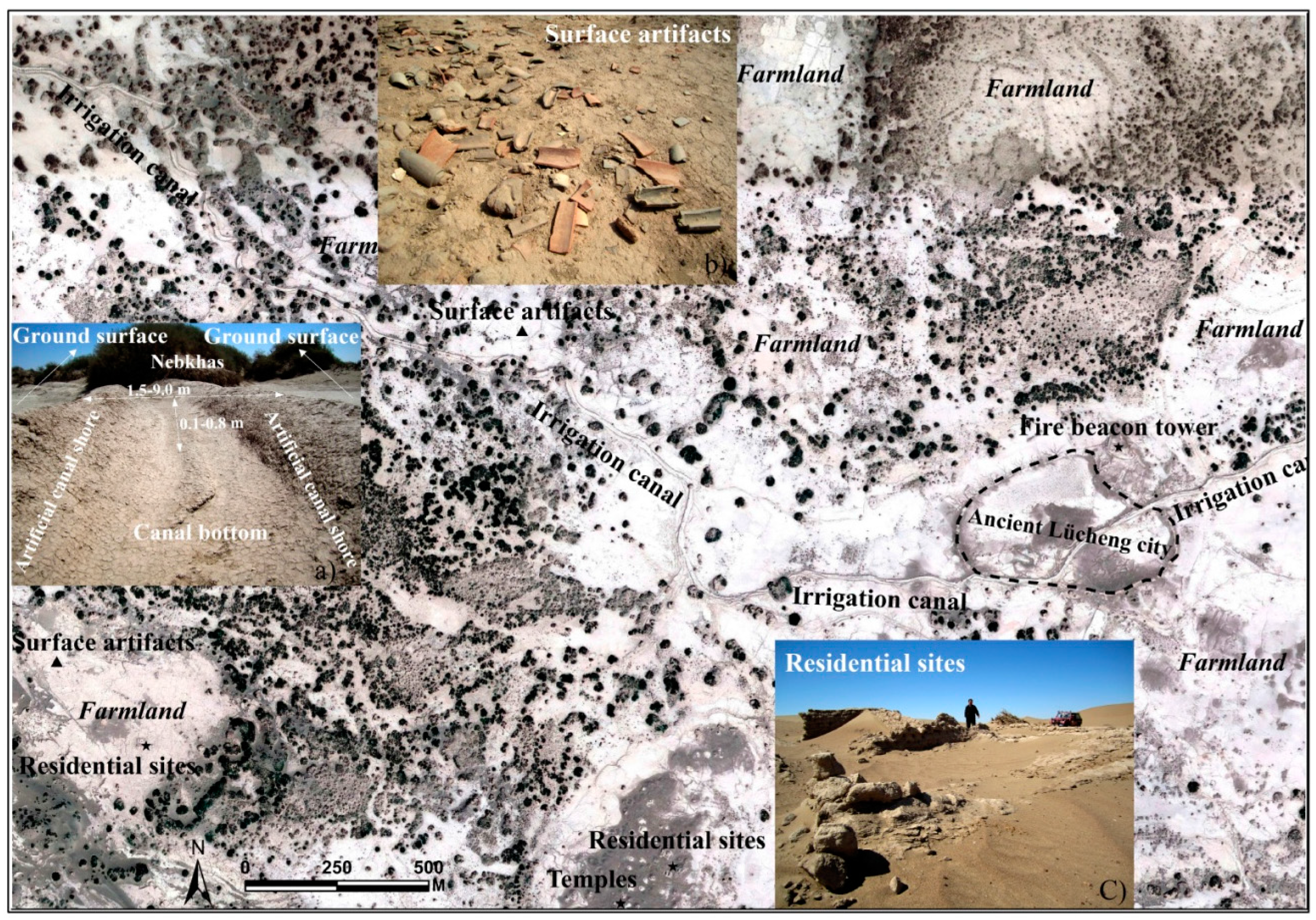
Figure 2.
Ancient irrigation canals and farmlands in the central south of the Juyan Oasis. (a) Ground-truth features of the irrigation canals; (b) Ground surface artifacts; (c) Field photo of the residential sites.
Figure 2.
Ancient irrigation canals and farmlands in the central south of the Juyan Oasis. (a) Ground-truth features of the irrigation canals; (b) Ground surface artifacts; (c) Field photo of the residential sites.

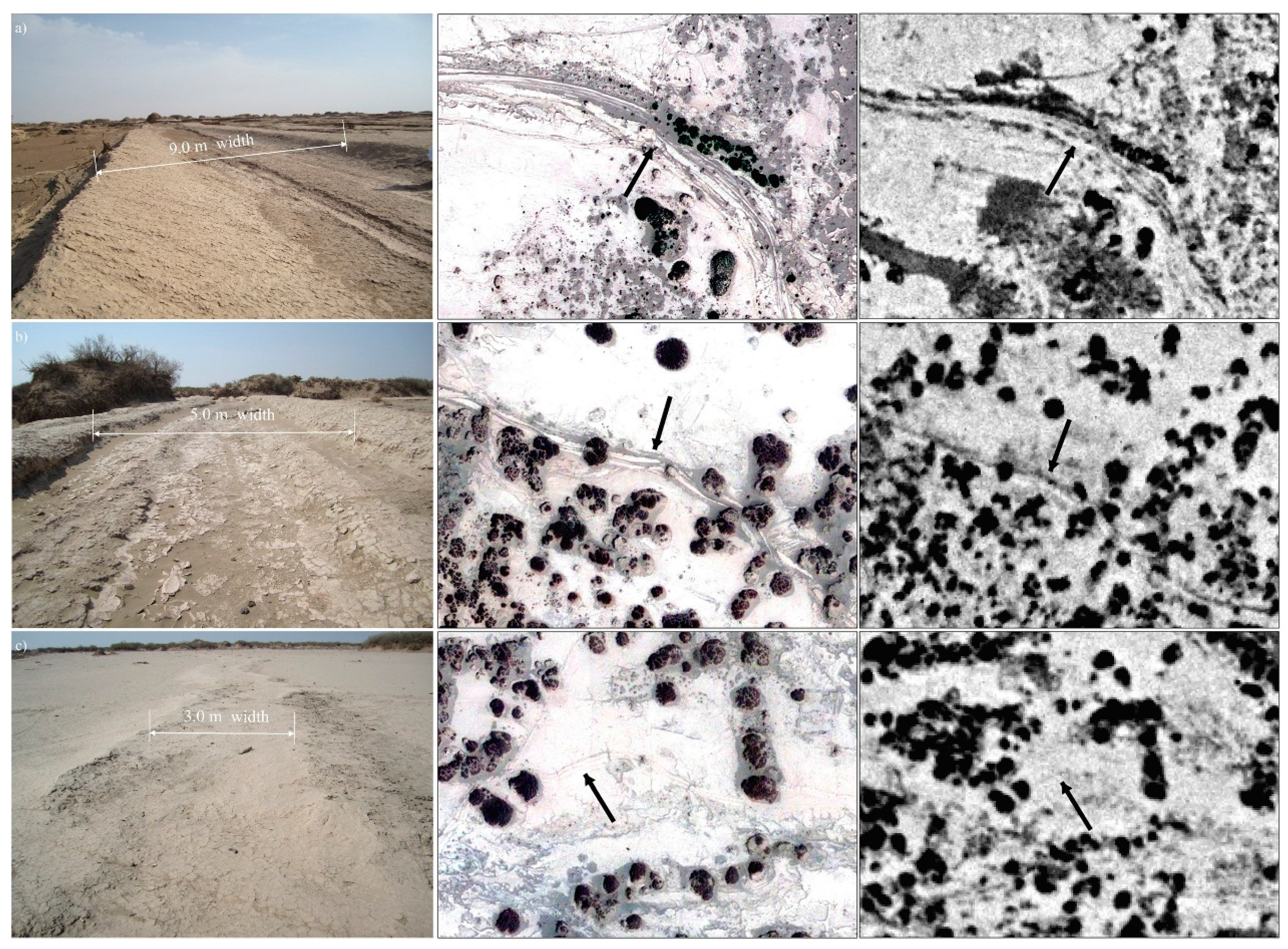
Figure 3.
Image features of the irrigation canals with different widths displayed in different images. The in-situ photos of the irrigation canals are showed on the left. The images in the middle are very high resolution (VHR), and the images on the right are CORONA imagery. (a) The widest large-irrigation canal; (b) A representative moderate-irrigation canal; (c) A typical small-irrigation canal.

Figure 4.
Spatial distribution of the ancient irrigation canals identified using remotely sensed data. The sample canal points and misjudged ‘canal’ were investigated and positioned during fieldwork. The sampling points for dating are obtained from the previous studies [25,32,33,34].

Figure 5.
Hierarchical irrigation systems showing the first-, second-, and third-order irrigation canals. The arrow directions show the direction of water delivery, and the arrow shapes display the canals with different levels.
Figure 5.
Hierarchical irrigation systems showing the first-, second-, and third-order irrigation canals. The arrow directions show the direction of water delivery, and the arrow shapes display the canals with different levels.

Figure 6.
Image features and ground-truths of ‘canals’ that were initially misjudged using the remote sensing data. The images on the left show the canal-like features in VHR images. The photographs on the right show the ground characteristics of the ‘canals’.
Figure 6.
Image features and ground-truths of ‘canals’ that were initially misjudged using the remote sensing data. The images on the left show the canal-like features in VHR images. The photographs on the right show the ground characteristics of the ‘canals’.

© 2017 by the authors. Licensee MDPI, Basel, Switzerland. This article is an open access article distributed under the terms and conditions of the Creative Commons Attribution (CC BY) license (http://creativecommons.org/licenses/by/4.0/).
Share and Cite
MDPI and ACS Style
Hu, N.; Li, X.; Luo, L.; Zhang, L. Ancient Irrigation Canals Mapped from Corona Imageries and Their Implications in Juyan Oasis along the Silk Road. Sustainability 2017, 9, 1283. https://doi.org/10.3390/su9071283
AMA Style
Hu N, Li X, Luo L, Zhang L. Ancient Irrigation Canals Mapped from Corona Imageries and Their Implications in Juyan Oasis along the Silk Road. Sustainability. 2017; 9(7):1283. https://doi.org/10.3390/su9071283
Chicago/Turabian StyleHu, Ningke, Xin Li, Lei Luo, and Liwei Zhang. 2017. "Ancient Irrigation Canals Mapped from Corona Imageries and Their Implications in Juyan Oasis along the Silk Road" Sustainability 9, no. 7: 1283. https://doi.org/10.3390/su9071283
Note that from the first issue of 2016, this journal uses article numbers instead of page numbers. See further details here.