Exploring Flood Resilience Thinking in the Retail Sector under Climate Change: A Case Study of an Estuarine Region of Taipei City


1
Department of Architecture and Urban Design, Chinese Culture University, Taipei 11114, Taiwan
2
Department of Architecture, Tamkang University, New Taipei City 25137, Taiwan
*
Author to whom correspondence should be addressed.
Sustainability 2017, 9(9), 1650; https://doi.org/10.3390/su9091650
Submission received: 29 June 2017
/
Revised: 11 September 2017
/
Accepted: 11 September 2017
/
Published: 17 September 2017
(This article belongs to the Special Issue Physical Geography and Environmental Sustainability)
Abstract
:With predictions of extreme precipitation and sea-level rise under climate change that may induce morphological changes of estuaries, increased estuarine flood risk needs to be considered. The aim of this case study was to contemplate sustainability from the perspective of flood resilience that focuses on environmental problems and solutions. The study provided insights into retailers’ resilience thinking regarding the flood-prone Shetzu Peninsula in Taipei City. It is of concern that the retailers strategically identified potential flood risks and have developed adaptive knowledge, skills, and networks. The Location Quotient (LQ) analysis was conducted to verify that the retail sector of Shetzu Peninsula was considered a basic industry. Further assessments, an interactive visualization model and a consumption intensity map, were provided as supportive data. Based on the results, semi-structured interviews were conducted to explore 15 key retailers’ resilience thinking on how to adapt to floods in terms of risk communication under climate change. This approach is vital to meet the adaptation challenge in the Shetzu Peninsula. As a result, the study indicated that retailers have strategically identified potential weather-related risks and have implemented adaptation plans for each store functions. The study discussed that, in the face of climate change, maladaptation, interactive visualization models for communicating flood risks, and place attachment are key issues to increase flood resilience under climate change. The introduction of adaptation interventions in terms of urban resilience as a part of a comprehensive strategy helps to manage the impacts of climate change towards urban sustainability.
1. Introduction
Climate change is inherently linked to sustainable development issue; adaptation and development are considered as the two major challenges of the 21st century, and the need to tackle them together is a widely accepted discourse [1,2]. Increasing attention is being placed on the role of the private sector to support disaster and climate resilience [3]. According to flood hazard level, recent works on flood-risk assessment have estimated for the global population and found that gross domestic products (GDPs) are at risk to river-flooding exposure in the present climate and under future climatic changes [4,5,6]. Research efforts have also pushed forward the understanding and the mapping of flood risk under present and future climate conditions to better inform people on their adaptability and resilience. However, climatic impacts and uncertainty that are experienced locally [7] are challenging the local sustainable development.
As the retail sector is expected to be influenced the most by flooding [8,9,10], this study sought to explore 15 key retailers’ resilience thinking on how to adapt to floods in terms of risk communication under climate change. It is noted that damages to the retail sector greatly affect communities in terms of jobs, essential goods, and services. The study site is a flat sandbar in the villages of Taipei City, located in an estuarine region at the junction of the Keelung and Tamsui Rivers in Taiwan. The focus was on the retailers’ perceptions of coping with and adapting to floods under climate change [11,12,13]. The study underlined the importance of climate impacts that are closely correlated with the level of attachment that individuals experience around their settlement or place. This concept of place attachment describes one of the three elements: the identity created around a settlement or place, a sense of pride associated with belonging to a village, town, or city, and the friendships and networks that exist within them [14]. Most of the cumulative results of such human–environmental interactions are directly reflected by human adaptability in responding to the environmental impacts [15,16]. The present study underscored the important elements in advancing community flood resilience and sustainability, in particular, local knowledge, skills, and networks of the community and their contribution to the people’s well-being and their quality of life.
In the following section, the study introduces an interactive visualization model and a consumption intensity map to simulate the impact that could be informed by geographic contexts. Furthermore, Location Quotient (LQ) analysis was used to explore the industrial concentration under flood scenarios of both extreme precipitation and sea-level rise. Supported by the visualization model, the consumption intensity map, and the LQ approach, semi-structured interviews were conducted to explore retailers’ responses to climate change and their resilience thinking in terms of sustainability. As a result, the study indicated that retailers have strategically identified potential weather-related risks and have implemented adaptation plans for each store function. In addition, the study discussed that, in the face of climate change: (1) maladaptation often occurs when adaptation measures only focus on short-term objectives; (2) visualization model helps stakeholders communicate flood risks towards resilience; (3) flood resilience denotes reducing flood risk by raising risk perceptions of the community; and (4) place attachment is emerging as an important factor for climate adaptation. The final section summarizes the insights of this paper, and calls for the introduction of adaptation interventions in terms of flood resilience as a part of a comprehensive strategy to manage the impacts of climate change towards urban sustainability.
2. Materials and Methods
2.1. Study Site: A Flat Sandbar of Taipei City
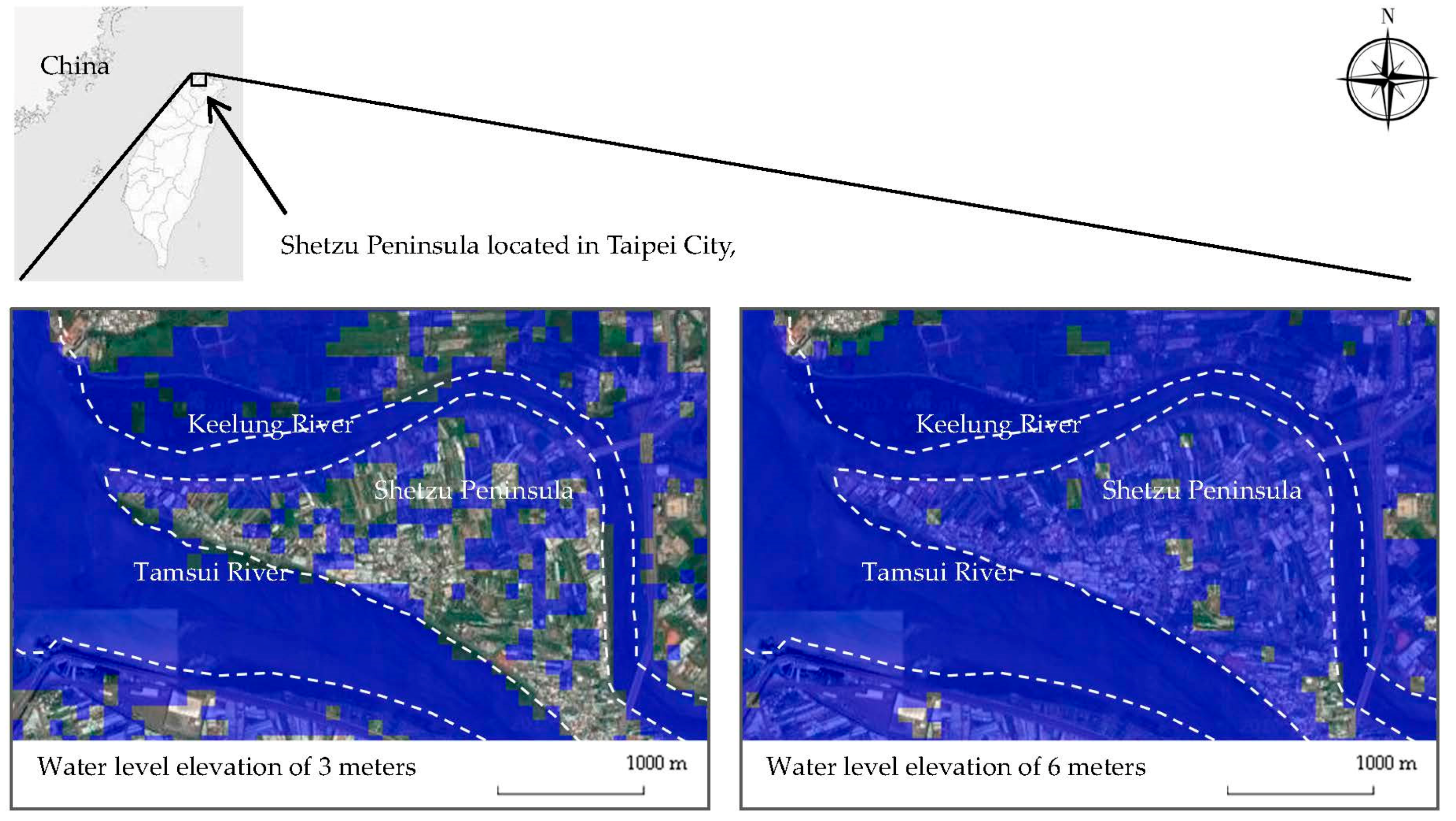
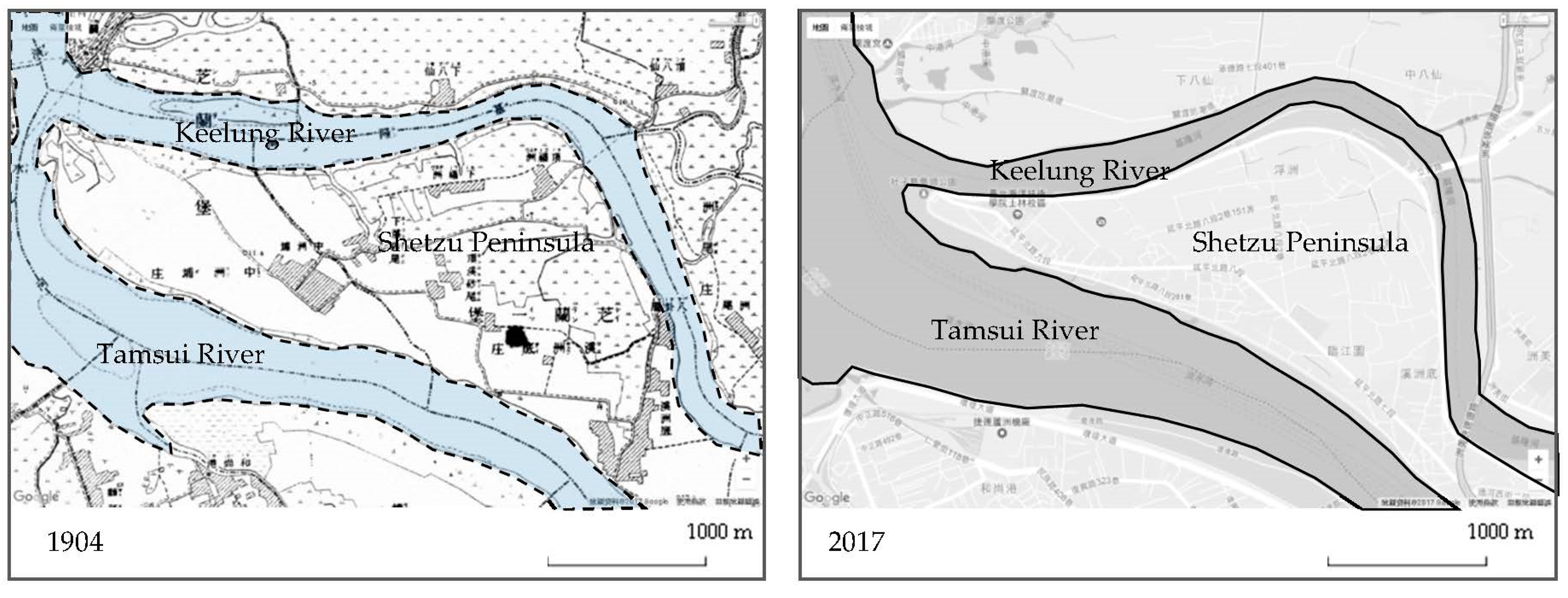
Flooding is considered to be the most immediate risk from climate change to Taipei City that is developed near a river mouth, characterized by flood plain and low-lying topography in a coastal zone [17]. An illustrative case is the Shetzu Peninsula, which is a low-lying and flat sandbar located in an estuarine region at the junction of the Keelung and Tamsui Rivers of Taipei City, Taiwan. Although Taipei is a highly developed city and has completed flood-control projects, it is still very vulnerable to flooding when extreme climate events [17], e.g., sea-level rise, occur (Figure 1). Figure 2 shows the fort map’s contour of Taiwan, which was published in 1904, and aerial photographs taken in 2017 (Google Map) demonstrate the geomorphic changes in the Shetzu Peninsula. In 1963, Typhoon Gloria generated heavy rainfall, which induced a surge of river water, flooding the Shetzu Peninsula. In light of this disaster, the national government began addressing flood risks in Taipei. In 1970, the Taipei Region Flood Control Project was completed, designating the Shetzu Peninsula as a detention basin to reduce flood risks in other parts of Taipei. As the Shetzu Peninsula developed rapidly and the population grew, the government subsequently installed flood-control infrastructure, such as embankments and pumping stations. However, the functionality of the flood detention basin and the embankment in Shetzu Peninsula was the lowest protection height in Taipei. In addition, construction was banned to restrict population growth and land use. Although Shetzu Peninsula has been restricted to low-density development, approximately 10,000 residents, whose families have lived there for generations, have continued to reside in the area. For more than four decades, these residents have lived in settlements and houses that have been banned from major repairs and alterations.
After the embankment was built, Shetzu Peninsula seemed to exhibit the capacity to cope with the magnitude of the flood disembarked by Typhoon Gloria (1963). A close examination of the residents’ environmental and socio-cultural perceptions revealed that the local residents acquired knowledge about the impacts and adaptation to environmental threats based on flood-risk perceptions [20]: people who have experienced related impacts exhibit more knowledge and skills compared to those who have not [21]. However, Shetzu Peninsula residents currently rely entirely on the hard infrastructure for flood control and have grown accustomed to it. Therefore, residents have difficulty imagining flood situations that may happen in the future, and this causes the impact of climate risk to increase [22]. It was argued that flood damages caused by extreme climate and weather events without any adaptive measures could progressively increase, causing damages to the infrastructure and the residents [23]. The Shetzu Peninsula is a flat sandbar in the villages of Taipei City, which is located in an estuarine region that is exposed to flooding; and where additional risks are imminent with climate change and remain unmeasurable.
2.2. Communicating Flood Risks
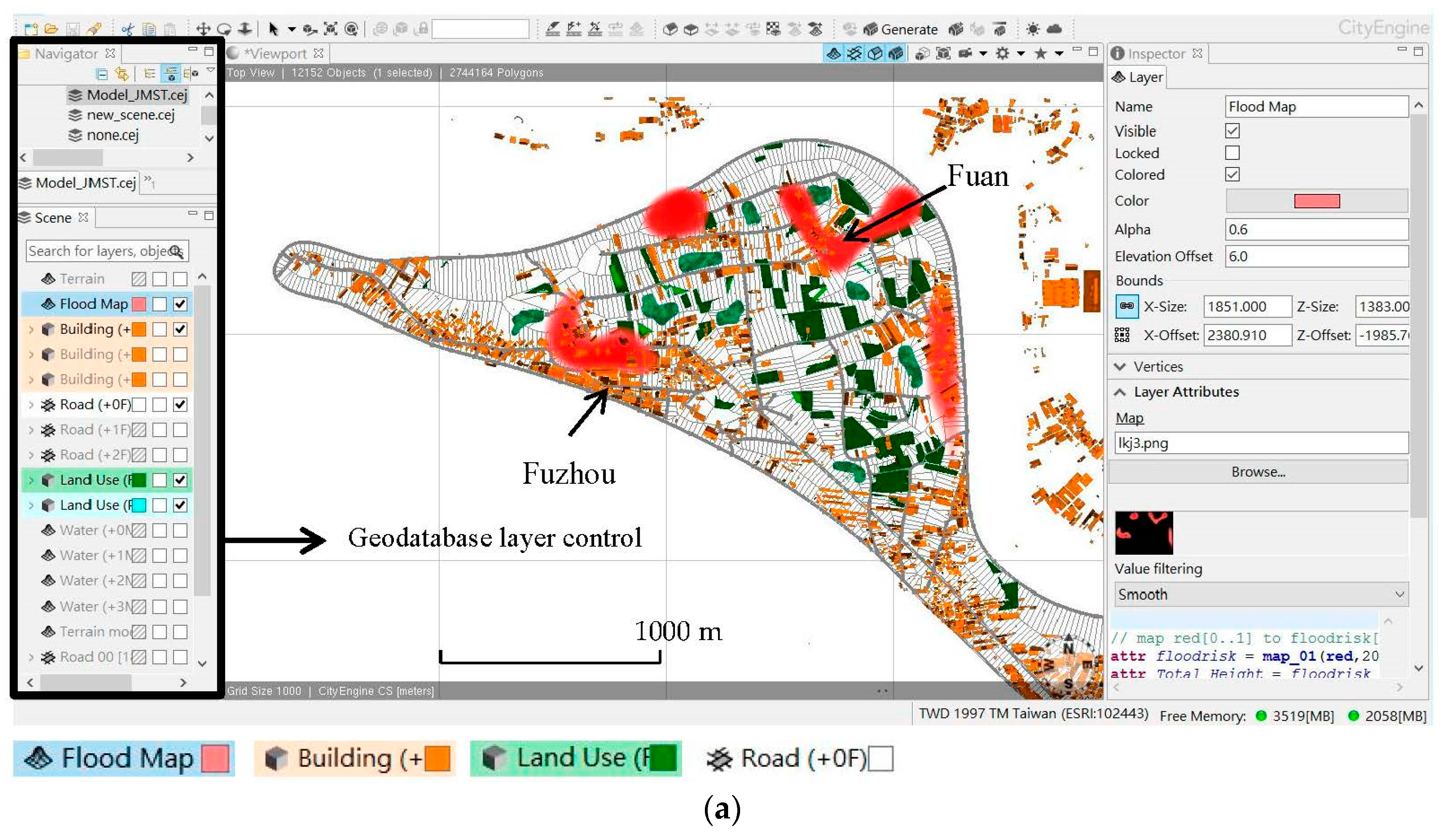
A science-based risk analysis with psychological risk dimensions may not be considered in technical risk assessments for cultural subgroups of society [24]. To help the local residents better understand and respond to the flood risks under climate change, this study used flood potential mapping and a rise in sea level scenario through an interactive visualization model to communicate flood risks with the local residents in the retail sector (Figure 3). It is noted that risk map may fail to represent the information base that is needed by stakeholders for selecting the suitable objectives and designing the appropriate actions for flood risk management [25]. This model focuses on raising awareness throughout presenting information relevant to the interest and location of the end-user [26,27]. It underlines the concept of place attachment that is already well established within sociology and geography, describing the identity created around a settlement or place [14].
The interactive visualization model uses Geodesign techniques to address the design and planning method that tightly couples with the creation of design proposals and the simulation of the impacts pertaining to geographic contexts [28]. It provides a design framework and supporting technology for professionals to manipulate geographical information, emphasizing environmental evidence-based data, design, and decisions. In a typical Geodesign procedure, the opinions and collaborations of the public, designers, decision-makers, and related stakeholders are necessary during the project planning and design stage [29]. The study used the three-dimensional modeling software program designed by Esri CityEngine to create an interactive visualization model. This model is equipped with a procedural modeling approach and a strong online model-sharing service for smoother communication and interaction with stakeholders, such as the local residents and policy-makers [30].
2.3. Identifying Key Industrial Sector
As mentioned above, the retail sector is expected to be the most affected by flooding. The study further conducted Location Quotient (LQ) analysis to verify if the key industrial sector of Shetzu Peninsula is referred to as a retail sector, by focusing on regional sectoral composition and concentrations of cluster activity [32,33]. The LQ technique is based on economic base theory and is the oldest, simplest, and most widely used technique for regional economic analysis [34]. It estimates the share of an economic activity in a spatial unit compared to the corresponding share of this activity in the national or specific denominator region’s economy [35], which, in terms of a variable, in this study, is the employment. The focus was put on the analysis of the economic base in an area to identify key industrial sector and focus groups of the study for formulating appropriate measures to be adapted to local conditions (problems, needs, and potential of the area) [36] in regard to climate change.
The LQ analysis identified the employment concentration by utilizing the data from the government census of the period: 2006–2015 [37,38]. This approach addresses industrial sectors that differ significantly in respect to exposed assets and susceptibility to floods [39]. In addition, LQ analysis determines the highest concentration for sectoral composition for an area, identifying a local measure of geographical concentration of industries by comparing the local share of jobs in a specific industry and in the City. It was noted that (Table 1):
- An LQ greater than 1.0 indicates that an area has proportionately more workers than the larger comparison area employed in a specific industrial sector [40], which implies that the area is producing more products or services than is consumed by area residents, and the excess is available for export outside the area.
- An LQ significantly less than 1.0 indicates that the industry is a non-basic industry for the area, which denotes industries that do not exert significance in the area.
- The rational underlying the LQ as a means of separating basic and non-basic industries is based on two measures: variance and magnitude. Variance reflects the degree of specialization of employment to a specific industry across a number of places. Magnitude of the LQ for a specific industry and place, can be interpreted to indicate that the activity is residentiary (self-sufficient), exported, or imported depending whether the LQ is greater than, less than, or equal to 1.0 [41].
Peripheral places, such as Shetzu Peninsula (compared to Shihlin District and Taipei City) would have smaller LQ deviation since the LQ indices represent the level of sectoral dominance in the regional economies and are to issue economic diversity, size and economic scale. That is, the industry in question may not show large location quotients because the relative importance of the sector is muted with respect to overall economic activity. Therefore, the study neglected to incorporate agglomerating influences and the sectoral distribution in the analysis, simply using LQ to correlate the regional convergence of retail industry within the sectoral distribution and with the relevant allocation of employment at regional level to define whether retail sector is the basic industry for Shetzu Peninsula.
The study took into account that the employment population disaggregated into sectors of manufacturing, electricity, gas and water, construction, retail, communication, finance and insurance, and service sectors. Data that were conducted every five years were gathered from the Industry, Commerce and Service Census of the Directorate General of Budget, and Accounting and Statistics (DGBAS) of Taiwan, and the census numbers from 2006 to 2011 were interpolated and used to extract the employments for 2005, 2007–2010, and 2012–2015, respectively. The census divides the employment data into two-digit sectoral division, where the different sector division categories were used in accordance to the 2001 and 2006 data divisions. It is noted that: (1) data from the industry and commerce census were compared to aggregated data from the Ministry of the Interiors of Taiwan; (2) data included annual demographic data (municipal level and national level), employment, industry and commerce census data in the eight sectors according to the two digit category; and (3) the aggregated ratio for the gap years of each census data (every five years) was used to conduct the LQ analysis. The LQ formula is:
where
- Ei,r is the number of employee jobs in industry i region r;
- Er is the number of employee jobs in region r;
- Ei is the number of employee jobs in industry i; and
- E is the number of employee jobs in Shetzu, Taipei City.
The study focused on the three villages of Fuzhou, Fuan, and Yonglun that are located in Shetzu Peninsula. These areas are identical to the redevelopment areas proposed by Taipei City. The study computed proportionally the employment population from the extrapolated employment in the industry and commerce and services census of 2006 and 2011 from the growth ratio obtained from the annual population census from the Ministry of Interiors; and the results were used to explore the employment population for the other gap years between the two censuses. For the three villages of Fuzhou, Fuan, and Yonglun, the sectoral employment of each neighborhood was computed proportionally with the total employment extrapolated for the Shihlin District. After obtaining the extrapolated employment for the years of 2005–2015, the LQ analysis was conducted.
This approach enabled the observation and analysis of any LQ changes in the three villages and the opportunity to compare the results to that of Shetzu Peninsula and Shihlin District. The LQ approach represents the level of sectoral dominance in the regional economies and is sensitive to issues of economic diversity, size and economic scale. The study neglected to incorporate agglomerating influences and the sectoral distribution in the LQ analysis to correlate the regional convergence of retail industry within the sectoral distribution with the relevant allocation of employment at local level. This helped to understand the changes in the industrial sectors of the studied site and to identify the key industry of the Shetzu Peninsula in the retail sector.
2.4. Semi-Structured Interviews
Supported by the interactive visualization model, the consumption intensity map, and the LQ analysis that identified key industrial sector, a semi-structured interview process was conducted using focus groups. The study underlined that studies that use more than one method require fewer participants, as do studies that use multiple (very in-depth) interviews with the same participant [42,43]. For this reason, only 15 respondents were included in the study. As such, the semi-structured interview process continued until the respondent either repeated the same answers or was not able or willing to answer [44].
It was underscored that the risk events occur in a societal context and that the residents who provide a vital workforce would acquire an understanding of flood risks and have adopted acceptable levels of these risks. It was also argued that the flood-resilient residents are able to tell a “story” about the environmental impacts, and that their response collaborates with researchers [45]. The interview process underlines another aspect that complicates how people perceive, evaluate, and act on climate change risks, namely the concept of social amplification of risk framework [46,47]. That is, social and cultural risk amplification processes modify perceptions of risk in terms of risk communication [48]. It was noted that risks are communicated through different signals, such as images, and these signals can amplify or attenuate the perception of risks and their manageability [49]. That is, the semi-structured interview was used to determine the respondents’ flood-risk perceptions that are related to their flood resilience thinking under climate change. The interview addresses residents’ reactive awareness, their proactive actions in response to climate change, and their inextricable blend of face and feeling, reason and gut reaction, and cognition and intuition [50]. The interview format helped to provide insights into retailers’ resilience thinking in a systematic manner and enabled us to have an open dialogue with residents and explore how risk events interact with psychological, social, and cultural processes [51].
The study underlined that flood risks refer to the local residents’ knowledge, skills, and networks (indices) that organisms accumulate during their developmental processes, which reflect their adaptability to the changing environments; the changing of social relations and the context lead to a change in the meaning of places [52]. The indices of knowledge, skills, and networks are built upon a psychological methodological perspective, and reflect an uncertainty related to the input data and provide emphasis on the qualitative character of the assessment results in terms of potential impacts [13,51]. The study argued that the indices refer to residents’ preferences, values, attitudes, behaviors, and decision models, which the individuals exhibit differently depending on the environments and their perception of these environments. These differences cannot be evaluated using physical geographical data. Therefore, flood resilience in the retail sector was explored based on human adaptability by using the three indices: knowledge, skills, and networks. The study underlined that human adaptability positively influences individual responses to the impacts of climate change. Consequently, the indices were calculated using positive points.
It is noted that human adaptability, which influences risk perceptions, is the key to coping and adapting to changes toward social resilience [52,53]. Human adaptability reflects the influence of various impacts on individuals and is strongly related to individual knowledge and skills, socioeconomic structures, and institutional policies [52]. The learning of new knowledge and skills to reduce vulnerabilities and manage climate change risks also help achieve sustainability [54]. Many studies have also started to focus on the role of social networks, and the frequency with which people talk to or are influenced by close friends and family on the issue of climate change [55,56].
The study conducted semi-structured interview schedules with respondents who were key retailers of the village of Fuzhou. The interview was open-ended, allowing new ideas to be brought up during the interview by the respondents. That is, the interview design allowed us to have open dialogues with the respondents, noting that risk events interact with psychological, social, and cultural processes, which helped to guide the interviewing process towards an understanding of respondents’ resilience thinking in a systematic manner [51]. The respondents were selected to represent age, gender, occupation, and leadership. Interviews took place in their stores. All of the interviews were recorded and transcribed. Interview questions with specific themes included exploring memories and responses to the flood scenario of both extreme precipitation and sea level rise, focusing on their awareness of the potential flood risk in the future climate.
Respondents’ opinions were then arranged according to the aforementioned indices: knowledge, skills, and networks (referred to human adaptability), and the keywords of building, road, land use, and flooding (referred to risk information) based on the interactive visualization model (Figure 3). The categorical values of the respondents’ flood-resilience thinking can, thus, be obtained. Supported by those indices and keywords, the study developed and used an interview guide focused on respondents’ human adaptability and risk information as follows:
- Human adaptability: Have you ever gained any knowledge, used any skills, or shared your knowledge or skills in your neighboring networks? (if referred to one index, note value “1”).
- Risk information: Are you aware of the protection of buildings, roads, and land use against flooding (if referred to one keyword, note value “1”).
This interview guide addressed an informal grouping of topics and questions on how to adapt to floods in terms of risk communication under climate change that the interviewer can ask in different ways for different respondents.
3. Results
3.1. Retail Sector in Adapting to Climate Change
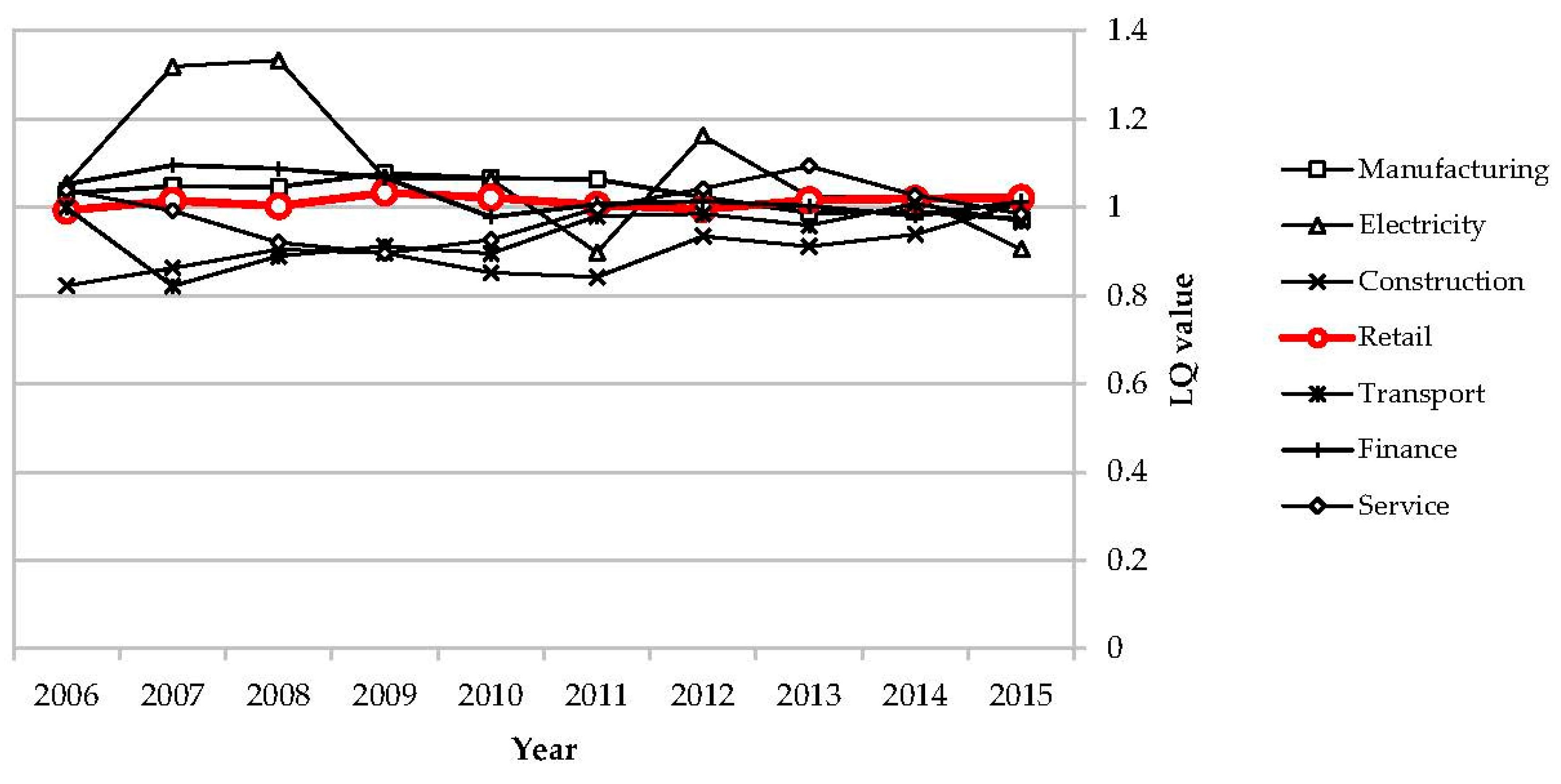
The LQ analysis was conducted for the time period of 2006–2015 (Table 2; Figure 4). The result reflects that retail sector is the basic and residentiary (self-sufficient) industry of Shetzu Peninsula with average LQs above and near 1.0 and with small standard deviation that may determinate a long-term influence of one sector with respect to one another. All three villages in Shetzu Peninsula exhibited similar Location Quotient results, but with the retail sector having the most consistent LQ for most of the years that the analysis was conducted. Among all the industrial sectors that had a LQ > 1.0, this study focused on retail-related businesses, as retail is the consistent basic industry in Shetzu Peninsula. That is, most of the residents in the study site rely on retail for their daily needs, and the adaptability of the retailers is pivotal to substantiate residents’ livelihood.
The study further indicated that: (1) industry sectoral composition remain even in the past few years, having retail, construction, and financial exhibiting an LQ >1.0; (2) urban industries tend to be allocated within Shetzu Peninsula is in accord to Taipei City, since the tertiary industry that provides services to its consumers has taken the lead in concentration; (3) tertiary industry distribution in Shetzu Peninsula is quite dispersed within the urban vein, having a concentration throughout the area; and (4) retail’s LQ performs in accordance with the national trend, and the retail sector was identified as the basic industry for Shetzu Peninsula throughout the study period.
As a result, the study indicated that: (1) the retail sector consistently showed a LQ >1.0 in the time period of 2013–2015; (2) tertiary industry distribution in Shetzu was quite dispersed within the urban vain, having a concentration throughout the area that was in accordance to the residential area along the artery road; and (3) the persistent higher LQ for the retail sector alerted the authors that, if it continues to exhibit the trait of basic industry, then the land use practice, building height, and usable ground floor should consider the floor height practice, as being just above ground level is considered suitable.
3.2. Human Adaptability and Risk Information
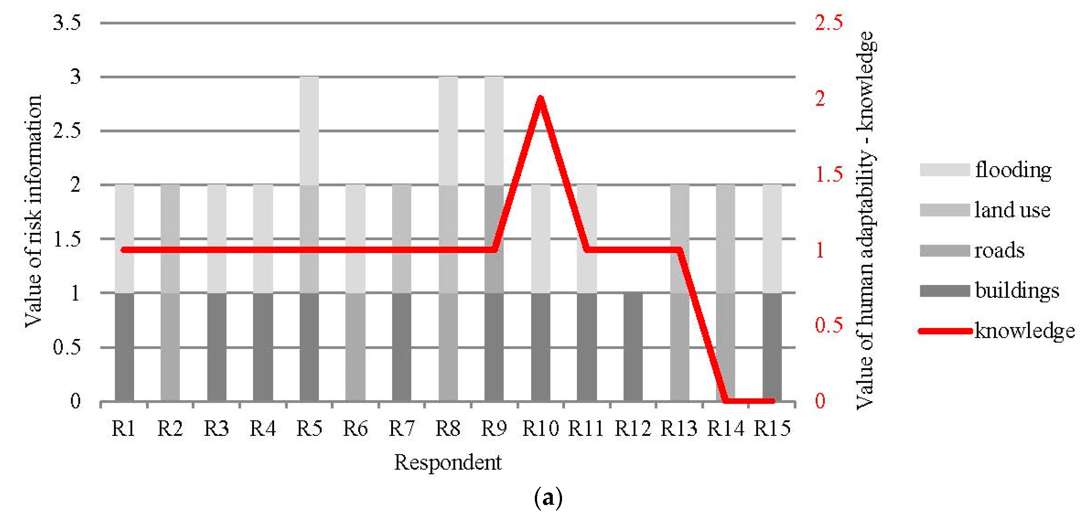
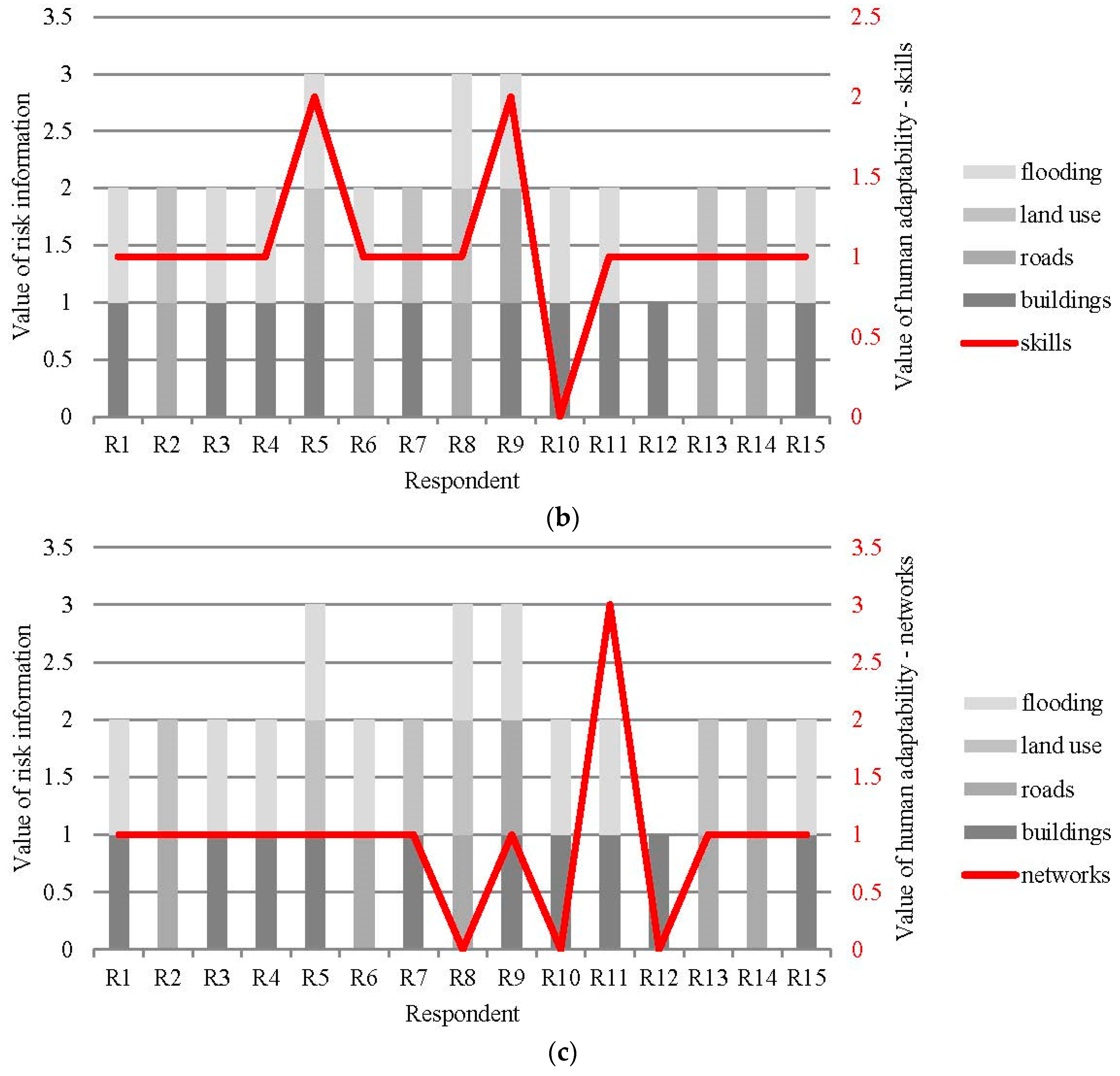
Supported by the visualization model, the consumption intensity map, and the LQ analysis that identified key focus groups of the study, the semi-structured interview process sought to explore key retailers’ resilience-thinking on how to adapt to floods in terms of risk communication under climate change. The interview process was conducted with 15 respondents, who were key retailers of the village of Fuzhou, and continued until no new relevant information could be obtained from respondents. As mentioned above, they either repeated the same answers or were not able or willing to answer. From all 15 respondents (R1–R15), significant messages on their resilience-thinking focused on human adaptability (referred to knowledge, skills, and networks) and risk information (referred to buildings, roads, land use, and flooding) in the retail sector was gained repeatedly as follows:
Knowledge
- R1 and R10: During Herbert Typhoon in 1996, the flood was about 1 m or more and lasted over a week; there was no more flooding after the incident.
- R5, R9, and R12: Many retailers have worked here with their families for over 20 years, and have indicated that there has been no flood ever since.
- R6 and R13: Most of the residents exhibit robust confidence on a future without flooding since nowadays heavy rain only causes rainwater overflow and not a flood.
- R6 and R7: Typhoon Herbert (1996) left the premise with a flooding above 1 m since the location is on the lowest part of the Peninsula.
- R3 and R10: The experience with the flood is most vivid because it was the time that the mayor came to visit them on a boat.
- R4 and R6: The flood only came up to about 30 cm and was manageable; there was no need to do anything else.
- R8, R11, and R13: Flooding is something that no longer exists and should not be a topic at all. Everything is fine in the Shetzu Peninsula.
- R4, R9: Living quality in Shetzu Peninsula far exceeds the quality of downtown and flooding is really non-existent.
Skills
- R3 and R5: Many buildings were renovated and elevated to decrease the risk of flooding.
- R2 and R8: The entire village was flooded, but the residents never moved away because the store is rented and they live in the back of the main street; they still hang on to their businesses.
- R6, R9, and R12: The elevated floor was either an earlier construction or newly elevated; it was elevated prior to their rental of the place.
- R1 and R13: The flooding was just getting the ground floor wet and t the furniture was put back back; it was really nothing serious.
- R1, R3, and R14: The flood is a term in the past for them, since now with the pump station is installed, and the dike really maintains the status quo in the village.
- R5, R7, and R11: Everything turned around after the construction of the connecting bridge, building up the dike, and adding the water pump; no flooding has occurred since then, even in the lowest ground level in Shetzu.
- R5 and R15: Flooding is not an issue in today’s Shetzu Peninsula since the dike was built.
- R7 and R9: The government should not spend money trying to elevate the ground level against flooding.
Networks
- R2, R13, and R14: Most of the retailers have lived here for over two decades and have no will to move away.
- R4 and R11: The local people have been alerted through LINE (an instant messaging application) as there was a risk of flooding.
- R2 and R11: The water came almost to chest level, and the Mayor came on a boat and gave locals food.
- R11 and R15: Rain water just overflowed for a bit and their family has been living there for over three generations; they began working in a tech company in Taipei and are still living there.
As a result, the study indicated that retailers have strategically identified potential weather-related risks and have implemented adaptation plans for each store function. This builds resilience and helps the retailers provide needed goods after natural disasters [57]. The statistic distributions of respondents’ human adaptability on knowledge, skills, and networks in comparison to their risk information on buildings, roads, land use, and flooding can constitute an example of exploring key retailers’ resilience-thinking on how to adapt to floods in terms of risk communication under climate change (Table 3 and Figure 5). The results indicated the different flood resilience-thinking of respondents, and formulated a diverse response system under climate change. It is also of concern that social-science knowledge of individual risk perception may be missing for an integrated urban flood-risk assessment [26,27].
4. Discussions
4.1. Maladaptation
Maladaptation often occurs when adaptation measures do not increase resilience, reduce vulnerability, or merely focus on short-term objectives and overlook long-term and overall considerations [58,59]. Maladaptation describes a situation where the negative impacts caused by adaptation decisions are as serious as the climate impact being avoided [60]. Given the spatial and temporal complexity of climate change problems and responses, it is likely that the actions that are judged by one group as successful adaptations may be judged by other groups, located in a different place and time, as being unsuccessful [61]. That is, some practices may meet the needs of one group, while increasing the vulnerability of others; sometimes, certain practice policies may deter future choices by implementing costly engineering responses [62].
The case of Shetzu Peninsula reflects a planning obstacle that is commonly found in Taiwan, as the focus of the Taipei City government is strengthening hard defenses, such as embankments and pumping stations, and prohibiting construction. Specifically, planning units were disconnected from local expectations; and adaptation measures could not fulfill the needs of urban resilience. When risks arise, the planning units seek to continually enhance infrastructure and fail to adapt strategies according to local needs; the general public lacked related knowledge, rendering a delay in reaching consensus for appropriate development plans and obstructing the improvement of local resilience. The interview results showed that the human adaptability and risk information of the respondents exist, causing the residents and governmental planning units to fail to identify appropriate developmental mechanisms. In respond to flood risks, the governmental approach may be maladaptive, whereas regarding to climate-change risk, the residents exhibited a notable capacity in their knowledge of impacts and adaptation. The planning units developed maladaptation strategies that were inconsistent with the needs of local residents, thus, failing to properly address the impacts referred to flooding. Adaptation strategies should primarily focus on bridging the gaps in these aspects of local needs and implement strategies to solve the skewed asymmetric knowledge within the challenges of the impacts of climate change. The study underscored that adaptation strategies should consider all options, investigate all practices, and screen for possible adverse effects. Maladaptation may increase the vulnerability and risks in a system or a sector of adaptation policies.
4.2. Visualization Model
This visualization model is efficient in achieving rapid results in shared understanding of flood risk issues. The interactive, dynamic and flexible nature of the model, combined with the immediacy with which information is presented by the map and graphic symbols, can facilitate and speed up the process of dissemination and communication among stakeholders [25]. During the interview process, the interactive visualization model was successfully used as an effective communication medium between interviewers and respondents. The development of sea-level rise scenarios in a three-dimensional model helped to raise respondents’ awareness of flood risk and to participate in the interview process. The study underlined risk communication as an evidence-based approach in the process of informing people about potential hazards (high stress, high concern, or controversy) to the residents themselves, their properties, or their community [63]. It was argued that the model can also become a discussion tool in the decision-making process. The model underscores a Geodesign approach to the environmental design profession that tightly couples the creation of design proposals with impact simulations informed by geographic contexts [28]. That is, the Geodesign approach provides a reference platform and supporting technology for professionals and the community to render and exchange geographic information, giving valuable input that can contribute additional information along with the environmental evidence-based data, design criteria, and the decision-making process. The progressive adaptive approaches and actions can be documented and contribute to the understanding of climate impact as well as facilitating the visualization of the changes and the space adaptation in a real-time simulation. That is, the visualization model functions by incorporating people, place, and policy into the decision-making process, which can help improve, implement, and resolve conflicts between stakeholders [64,65]. Eventually, the residents are anticipated to be able to investigate and execute adaptation strategies [66]. For instance, under flood scenarios of both extreme precipitation and sea level rise, environmental factors of Shetzu Peninsula such as embankments, houses, fields, and roads are displayed through the interactive visualization model for better communication with the locals.
4.3. Flood Resilience
The notion of flood resilience in this paper denotes reducing the vulnerability of Shetzu Peninsula that is exposed to flood risk by raising risk perceptions in developing responsive capacity of a changing climate. The study underscored that people’s judgments about risks are influenced by the ease with which relevant events come to mind [67,68]. Experiences of an extreme flood event might make climate risk more cognitively available or salient in people’s minds. A person’s experience with flooding (weather-related phenomena) provides a potentially important route to engagement with climate change [69,70]. While risks are situated within the social experiences and interactions of individuals, groups, and institutions, positive outcome after experiencing such a risk event is viewed as evidence of resilience [21].
Resilience-thinking, therefore, could be sustained and allowed for progressive emulsification. The concept of resilience has been gradually applied to managing risks, analyzing disasters, identifying vulnerability, and enhancing impact resistance [71,72]. In addition to hard defenses, resilience focuses more on a soft approach, such as social capital, economy, resources, and disaster-control policy mechanisms. Resilience through soft defenses is centered on human adaptability because when people are stricken by natural disasters, they rely on social capital to help them rebound and maintain basic living standards. Consequently, risk-control strategies no longer adopt the conventional prevention methods. Current risk-control strategies propose the building of resilience before impacts occur, and the use of these impacts to develop adaptation methods. This progressive approach applauds and assists strategies that emphasize absorptive, adaptive, and transformative capacities [30].
Shetzu Peninsula is a tide-influenced wetland along estuarine and riverine areas in Taipei, at the confluence of the Tamsui and Keelung Rivers, with a comparatively lower water table, sometimes below sea level; early settlers began to congregate along the Tamsui River side, on the higher land section of Shetzu, avoiding the central to northern area with comparatively lower water table. As part of the estuarine area, residents must use boats to move about along the riverside and to transport products to be sold in the nearby markets in Taipei City. This lifestyle proliferated during the time of the Japanese occupation. Even cargo ships discharged cargo in the ferry ports of these villages; with the government building dikes in Shetzu, flooding ceased to be part of the daily life of these residents [73]. Currently, such disaster-control engineering designs in Taiwan focus on single, partial risks or only considering limited factors into the scenario. In Shetzu Peninsula, embankment construction is considered to be the local flood risk solution. It was argued that, if basic facilities were designed with multiple functions from a large-scale perspective, their effects would be substantially enhanced, or if local resilience is considered in the design process, the result may be more tailored and suited for local adaptation. Moreover, public consensus regarding appropriate solutions has been lagging, and the effect of co-design cannot be observed nor tracked. The study suggested that the government incorporates communication and promotion into their policy development, thereby engaging all citizens in the decision-making process and facilitating the urban resilience.
4.4. Place Attachment
Place attachment is emerging as an important factor for climate adaptation is a concept that describes the level of connection that individuals have with the people and the environments in which they live; it is noted that the “place” is closely linked to the location and geographical character, while the people are linked to the local culture and demeanor, and they are closely tied to places [14]. In addition, culture plays a crucial role in generating useful coping strategies and can help communities to mitigate drivers and pressures in a timely and dynamic manner [51,74], which contributes towards the social resilience of neighborhoods. The study revealed that the retailers of Shetzu Peninsula, with a strong attachment to their community, are unwilling to migrate to maintain their income levels because they may be reluctant to leave behind their social and emotional support groups and adapt to a new community [14].
The study further indicated that the prior experience of a hazard in regard to risk perception, can also lead to different behavioral outcomes that are often mediated by other contextual factors [75]. It was also noted that the risk perceptions of the residence address integrated knowledge performance, while awareness refers to information collection [76]. Chamlee-Wright and Storr [77] argued that people’s expectations of the behavior of their neighbors and governments can profoundly affect the recovery strategies that they adopt, and influence that responses to flood risks. It is noted that indigenous knowledge that arose out of continuous experimentation, innovation, and adaptation, is blended into many knowledge systems to solve local problems [78]. Those local knowledge and skills that help decrease or prevent devastating climate change impacts are either location- or community-specific [79]. In addition, people need to forge network connections among rapidly changing communities of decision-makers and researchers to foster the necessary social learning for effective adaptation to climate risks [80]. Experiential learning is facilitated through an emotional response, which heightens the importance of the experience and its subsequent influence on attitudes toward risk [67].
Jointly, local knowledge, skills, and networks affect the local flood resilience and address a system that can be implemented when facing threats, but still retain the same controls of functionality and structure, while maintaining options for further development [81]. In addition, the adaptive actions of retailers toward flood resilience can inform and advance the decision-making process through climate risk perceptions and management [82], and that these actions are always initiated by risk perceptions [83,84].
5. Conclusions
The estuarine Shetzu Peninsula is the living habitat for local residents and provides the needed activity base for the local industries. This study focused on retailer’s flood-adaptive thinking that would enhance their resilience to climate change. Particular practices were documented for each store, in accordance to their perception of risks and practices that help to foster their own resilience when facing flooding risks. The risks of climate change are difficult to predict, and the impact of climate change is diverse [85]. Climate change is predicted to cause sea levels to rise and more extreme weather patterns, which may in turn cause a greater risk of tidal flooding, inland flooding from rivers, and surface water run-off [86]. The necessity for resilience thinking is most directly reflected by the adaptability of residents in responding to environmental impacts [15,16]. Adaptability, in turn, affects the risk perceptions of surroundings and differs among individuals, depending on their upbringing, perceptual experience, and epistemological systems from which subjective environmental images are constructed [87,88]. Climate and environmental changes will further elevate the overall environmental risks, necessitating local residents to familiarize themselves with the government’s coping strategies and learn to respond to such risks.
The study compared the risk perceptions of the retailers who were exposed to the climate risks. It is important to understand that their response to every dimension of climate change is mediated by their local culture and lifestyle. The adaptability assessment was applied in semi-structured interviews to analyze and score risk perceptions of the local retailers and documented their adaptive capacity. It was argued that perceptions influence residents’ opinions and attitudes toward environmental changes. The place where residents reside reflects their reaction and adaptation as most residents have lived in the area for a few decades, allowing for the gathering of a deep understanding of the place. Considerable maladaptation practice is evident in the area, since the government’s adaptation measures merely focuses on short-term objectives and overlook long-term and overall considerations; the local people’s resilient lifestyle and practices, however, encourage the retailers’ flood resiliency.
The policies implemented may be maladaptive, but local residents’ capacity far exceeds the public sector’s assumption. The focus of the Taipei City government on strengthening the hard defenses, such as embankments and pumping stations, prohibiting construction, and maintaining low-density development revealed that these measures may encourage residents’ over-dependency on the embankment and, thus, neglect the potential impacts of future climate-driven flood. It was argued that future urban planning should be conducted on a local scale and an overall consideration basis provided to avoid maladaptation, rather than relying on a certain method alone. In addition, new adaptation strategies should take actions to bridge the gaps and strengthen local resilience. The study indicated that local adaptation methods are related to perceptions and practice methods, which are linked to the local community. It is noted that local adaptation is related to local practice; it is place-specific; and is initiated by risk perceptions.
The insights of this paper conclude with a perspective on flood resilience thinking that is based on risk perceptions among small business owners, and calls for the introduction of adaptation interventions in terms of flood resilience as a part of a comprehensive strategy to manage the impacts of climate change to head towards urban sustainability. Urban industries necessities advance adaptation approaches to moderate potential damages, take advantage of the opportunities and resilient practice, or used to cope with the consequences of climate change that affect people and places; and urban planning should incorporate the practice prior to any further actions. Current building code promotes the proliferation of the tertiary sector in the area, coupled with lower rents, which encourage the migration from the urban core towards the periphery areas in the Shetzu Peninsula. This demographic increase is accelerated by the development of the tertiary sector in the area. The interactive visualization model, through purposeful design, evaluation, decision, and implementation, elaborate on an integrative interface that guides the urban industries toward adaptive development. In turn, the design can assist policy and places to develop effectively. Place attachment describes the level of connection that individuals have with the people and environments in which they live, and may also shape localized adaptive responses. The study underlined the influence of local culture, experiences, and environments on people [52,89] as keys toward a comprehensive strategy to manage the impacts of climate change.
It was underscored that adaptive capacity influences risk perceptions, and perceived risk determines the residents’ responses [53,90]. That is, human risk perceptions and behaviors are inseparable portions of the coupled human–environment system. Resilience thinking offers a promising framework for framing flood risks posed through climate impacts and uncertainties, and the adaptive capacities that enable people to lead meaningful and dignified lives, which are still currently at risk from climate change [14,53]. The study further concluded that the respondents are highly adaptable to climate risks. Adaptive behaviors are the derivatives and embodiments of risk perceptions. The local retailers exhibited resilient perceptions because of their adaptability and resilience thinking that facilitated the formation of their knowledge and skills regarding their attachment to their home in the estuarine area. Place attachment describes the level of connection that individuals have with the people and the environments in which they live, and may also shape adaptive responses [14]. The study argued that the local retailers in this study demonstrated an adaptive neighborhood system that allowed them to absorb and recover from the impact of disruptive events without fundamental changes in the function or structure of their livelihood. The system regulates and guides individual behaviors and also applies resilience thinking as a transitioning model towards social and environmental sustainability.
Author Contributions
Yi-Chang Chiang conceived and designed the study; Yi-Chang Chiang and Tzen-Ying Ling analysed the data, contributed materials/analysis tools, and wrote the paper.
Conflicts of Interest
The authors declare no conflict of interest.
References
- Munasinghe, M. Addressing sustainable development and climate change together using sustainomics. Wiley Interdiscip. Rev. Clim. Chang. 2011, 2, 7–18. [Google Scholar] [CrossRef]
- Lama, A.K. Understanding Institutional Adaptation to Climate Change: Social Resilience and Adaptive Governance Capacities of the Nature Based Tourism Institutions in the Annapurna Conservation Area, Nepal; Würzburg University Press: Würzburg, Germany, 2016; p. 29. [Google Scholar]
- Clarvis, M.H.; Bohensky, E.; Yarime, M. Can resilience thinking inform resilience investments? Learning from resilience principles for disaster risk reduction. Sustainability 2015, 7, 9048–9066. [Google Scholar] [CrossRef]
- Arnell, N.W.; Gosling, S.N. The impacts of climate change on river flood risk at the global scale. Clim. Chang. 2016, 134, 387–401. [Google Scholar] [CrossRef]
- Winsemius, H.C.; Aerts, J.C.J.H.; van Beek, L.P.H.; Bierkens, M.F.P.; Bouwman, A.; Jongman, B.; Kwadijk, J.C.J.; Ligtvoet, W.; Lucas, P.; van Vuuren, D.P.; et al. Global drivers of future river flood risk. Nat. Clim. Chang. 2016, 6, 381–385. [Google Scholar] [CrossRef]
- Ward, P.J.; Jongman, B.; Kummu, M.; Dettinger, M.D.; Weil, F.C.S.; Winsemius, H.C. Strong influence of El Niño Southern Oscillation on flood risk around the world. Proc. Natl. Acad. Sci. USA 2014, 111, 15659–15664. [Google Scholar] [CrossRef] [PubMed]
- Carter, J.G.; Connelly, A.; Handley, J.; Lindley, S. European cities in a changing climate: Exploring climate change hazards, impacts and vulnerabilities; The University of Manchester: Manchester, UK, 2012. [Google Scholar]
- URS. Economic Impacts of Increased Flood Risk Associated with Climate Change in the North West. 2009. Available online: http://www.cumbria.gov.uk/eLibrary/Content/Internet/538/755/1929/421451113.pdf (accessed on 3 February 2017).
- Allianz. Wholesale and Retail—Our Proposition. 2014. Available online: http://www.allianzebroker.co.uk/content/allianzebroker/en_gb/application/content/documents/commercial-products/property-and-casualty/wholesale-and-retail/wholesale-retail-proposition/_jcr_content/documentProperties/currentDocument.res/acom6077-4.pdf (accessed on 3 January 2017).
- Leach, K. Impact of Flooding and Flood Risk on Community Economic Resilience in the Upper Calder Valley. 2015. Available online: http://www.nationalfloodforum.org.uk/wp-content/uploads/Calderdale-flooding-community-economic-resilience-final-Jan-2015.pdf (accessed on 3 January 2017).
- Adger, W.N. Social and ecological resilience: Are they related? Prog. Hum. Geogr. 2000, 24, 347–364. [Google Scholar] [CrossRef]
- Cutter, S.L. Social vulnerability to environmental hazards. Soc. Sci. Q. 2003, 84, 242–261. [Google Scholar] [CrossRef]
- Rannow, S.; Loibl, W.; Greiving, S.; Gruehn, D.; Meyer, B.C. Potential Impacts of Climate Change in Germany—Identifying Regional Priorities for Adaptation Activities in Spatial Planning. Landsc. Urban Plan. 2010, 98, 160–171. [Google Scholar] [CrossRef]
- Adger, W.N.; Barnett, J.; Brown, K.; Marshall, N.; O’Brien, K. Cultural dimensions of climate change impacts and adaptation. Nat. Clim. Chang. 2013, 3, 112–117. [Google Scholar] [CrossRef]
- Intergovernmental Panel on Climate Change (IPCC). AR4 Synthesis Report: Contribution of Working Groups I, II and III to the Fourth Assessment Report of the Intergovernmental Panel on Climate Change; Climate change 2007; Cambridge University Press: Cambridge, UK, 2007. [Google Scholar]
- Engle, N.L. Adaptive capacity and its assessment. Glob. Environ. Chang. 2011, 21, 647–656. [Google Scholar] [CrossRef]
- Chang, L.F.; Seto, K.C.; Huang, S.L. Climate change, urban flood vulnerability, and responsibility in Taipei. In Urbanization and Sustainability; Boone, C.G., Fragkias, M., Eds.; Springer: Cham, Switzerland, 2013. [Google Scholar]
- Burle, S. Flood Map: Water Level Elevation Map (Beta). 2012. Available online: http://www.floodmap.net (accessed on 29 June 2017).
- Academia Sinica. Taiwan FortMap’s Contour. 2017. Available online: http://gissrv5.sinica.edu.tw/GoogleApp/JM20K1904_1.php (accessed on 9 March 2017).
- Michael, D.M.; Nicole, E.H.; Terry, L.R.; Stephen, H.S. Bridging the gap: Linking climate-impacts research with adaptation planning and management. Clim. Chang. 2010, 100, 87–101. [Google Scholar]
- Seery, M.D. Challenge or threat? Cardiovascular indexes of resilience and vulnerability to potential stressing humans. Neurosci. Biobehav. Rev. 2011, 35, 1603–1610. [Google Scholar] [CrossRef] [PubMed]
- Smeets, E.; Weterings, R. Environmental Indicators: Typology and Overview. Technical report 25. European Environmental Agency, 1999. Available online: http://ilm.geogr.uni-jena.de/fileadmin/Geoinformatik/projekte/brahmatwinn/Workshops/FEEM/Indicators/EEA_tech_rep_25_Env_Ind.pdf (accessed on 2 February 2017).
- John, M. A Spatial Computable General Equilibrium Model for the Analysis of Regional Climate Change Impacts and Adaptation Policies. Hamburg Institute of International Economics (HWWI), 2014. Available online: http://www.hwwi.org/uploads/tx_wilpubdb/HWWI-Research-Paper_154_01.pdf (accessed on 22 January 2017).
- Slovic, P. (Ed.) The Perception of Risk; Earthscan: Sterling, VA, USA.
- Albano, R.; Mancusi, L.; Abbate, A. Improving Flood Risk Analysis for effectively supporting the implementation of flood risk management plans: The case study of “Serio” Valley. Environ. Sci. Policy 2017, 75, 158–172. [Google Scholar] [CrossRef]
- Albano, R.; Sole, A.; Adamowski, J. READY: A web-based geographical information system for enhanced flood resilience through raising awareness in citizens. Nat. Hazards Earth Syst. Sci. Discuss. 2015, 15, 1645–1658. [Google Scholar] [CrossRef]
- Kubal, C.; Haase, D.; Meyer, V.; Scheuer, S. Integrated urban flood risk assessment—Adapting a multicriteria approach to a city. Nat. Hazards Earth Syst. Sci. 2009, 9, 1881–1895. [Google Scholar] [CrossRef]
- Flaxman, M. Geodesign: Fundamental Principles and Routes Forward; GeoDesign Summit: Redlands, USA, 2010. [Google Scholar]
- Neuenschwander, N.; Hayek, U.W.; Grêt-Regamey, A. Integrating an urban green space typology into procedural 3D visualization for collaborative planning. Comput. Environ. Urban Syst. 2014, 48, 99–110. [Google Scholar] [CrossRef]
- Chiang, Y.C.; Huang, Y.C. Exploring Social Resilience: Insights Into Climate Change Adaptation Gaps From An Estuarine Region Of Taiwan. J. Mar. Sci. Technol. 2016, 24, 1081–1092. [Google Scholar] [CrossRef]
- MOEA (Ministry of Economic Affairs, Taiwan). Consumption Intensity Map. 2016. Available online: http://moeaegis.carto.com/viz/565b9586–9731–11e5-bb72–0ef7f98ade21/embed_map (accessed on 2 March 2017).
- Billings, S.B.; Johnson, E.B. The location quotient as an estimator of industrial concentration. Reg. Sci. Urban Econ. 2012, 42, 642–647. [Google Scholar] [CrossRef]
- Alhowaish, A.K.; Alsharikh, M.A.; Alasmail, M.A.; Alghamdi, Z.A. Location Quotient Technique and Economy Analysis of Regions: Tabuk Province of Saudi Arabia as a Case Study. Int. J. Sci. Res. 2015, 4. Available online: http://www.ijsr.net/archive/v4i12/NOV152375.pdf (accessed on 11 March 2017).
- Deniz, Z.Ã. Regional Economic Development and Competitiveness: A Study of Leading and Competitive Sectors of Diyarbakir-Sanliurfa Region, Turkey. In ERSA Conference Papers; (No. ersa14p167); European Regional Science Association: Saint Petersburg, Russia, 2014; Available online: http://ideas.repec.org/p/wiw/wiwrsa/ersa14p167.html (accessed on 1 August 2017).
- Christofakis, M.; Gaki, M.E.; LAGOS, D.; Poulaki, P. The Pattern of the Spatial Allocation of Economic Branches in Greece and the Impact of Economic Crisis. 15th Conference ERSA-GR. Available online: http://asrdlf2017.com/asrdlf2017_com/inc/resumes/182.pdf (accessed on 3 August 2017).
- Arafah, W.; Matheos, R.C.D. Determining factors of potential economy sectors of Bantaeng Regency in South Sulawesi Province of Indonesia: An analysis using the location quotient approach. Int. J. Bus. Manag. 2017, 12, 183–191. [Google Scholar] [CrossRef]
- DGBAS (Directorate General of Budget, Accounting and Statistics). Industry, Commerce and Service Census, 7th revised edition. 2011. Available online: http://eng.stat.gov.tw (accessed on 25 January 2017).
- HRO (Household Registration Offices, Shilin District, Taipei City). Demography Census. 2017. Available online: http://slhr.gov.taipei/ct.asp?xItem=132580425&ctNode=85436&mp=102031 (accessed on 5 February 2017).
- FEMA (Federal Emergency Management Agency). HAZUS-MH Technical Manual; Technical Report; Department of Homeland Security, Federal Emergency Management Agency, Mitigation Division: Washington, DC, USA, 2003. Available online: https://www.fema.gov/media-library-data/20130726–1820–25045–8292/hzmh2_1_fl_tm.pdf (accessed on 1 March 2017).
- Incontext. Location Quotients: A Tool for Comparing Regional Industry Compositions. A publication of the Indiana Business Research Center at IU's Kelley School of Business. 2006. Available online: http://www.incontext.indiana.edu/2006/march/1.asp (accessed on 27 January 2017).
- Mark, R.S.; Jacobson, D.S. Core periphery analysis of the European Union: A location quotient approach. J. Reg. Anal. Policy 1996, 26, 3–21. [Google Scholar]
- Mason, M. Sample Size and Saturation in PhD Studies Using Qualitative Interviews. Forum Qual. Soc. Res. 2010, 11. Available online: http://www.qualitative-research.net/index.php/fqs/article/view/1428 (accessed on 27 March 2017).
- Lee, D.T.F.; Woo, J.; Mackenzie, A.E. The cultural context of adjusting to nursing home life: Chinese elders’ perspectives. Gerontologist 2002, 42, 667–675. [Google Scholar] [CrossRef] [PubMed]
- Tools4dev. How to do Semi-Structured Interviews. 2015. Available online: http://www.tools4dev.org/wp-content/uploads/how-to-do-semi-structured-interviews.pdf (accessed on 15 May 2017).
- Kok, K.; Gramberger, M.; Simon, K.H.; Jäger, J.; Omann, I. Report on the New Methodology for Scenario Analysis, Including Guidelines for Its Implementation, and Based on an Analysis of Past Scenario Exercises. 2011. Available online: http://www.climsave.eu/climsave/doc/Report on the Scenario Methodology.pdf (accessed on 3 February 2017).
- Kasperson, R.E.; Renn, R.; Slovic, P.; Brown, H.S.; Emel, J.; Goble, R.; Kasperson, J.X.; Ratick, S. The social amplification of risk: A conceptual framework. Risk Anal. 1988, 8, 177–187. [Google Scholar] [CrossRef]
- Hagen, B. Public Perception of Climate Change: Policy and Communication. Routledge: London, UK, 2015. [Google Scholar]
- APA (American Psychological Association). Psychology and Global Climate Change: Addressing a Multi-faceted Phenomenon and Set of Challenges; American Psychological Association Task Force on the Interface between Psychology and Global Climate Change; American Psychological Association: Washington, DC, USA, 2009. [Google Scholar]
- Hagen, B. Public Perceptions of Climate Change: Risk, Trust, and Policy. Ph.D. Thesis, Arizona State University, Tempe, AZ, USA, 2013. Available online: http://citeseerx.ist.psu.edu/viewdoc/download?doi=10.1.1.659.3377&rep=rep1&type=pdf (accessed on 21 February 2017).
- Ropeik, D. Risk Perception. Nature.com Blogs. 2011. Available online: http://blogs.nature.com/soapboxscience/2011/05/11/risk-perception (accessed on 11 July 2017).
- Chiang, Y.C.; Tsai, F.F.; Chang, H.P.; Chen, C.F.; Huang, Y.C. Adaptive society in a changing environment: Insight into the social resilience of a rural region of Taiwan. Land Use Policy 2014, 36, 510–521. [Google Scholar] [CrossRef]
- Giddens, A. The Politics of Climate Change; Polity Press: Cambridge, UK; Malden, MA, USA, 2009. [Google Scholar]
- Safi, A.S.; Smith, W.J.; Liu, Z. Rural Nevada and climate change: Vulnerability, beliefs, and risk perception. Risk Anal. 2012, 32, 1041–1059. [Google Scholar] [CrossRef] [PubMed]
- Ming Lee, T.; Markowitz, E.M.; Howe, P.D.; Ko, C.-Y.; Leiserowitz, A.A. Predictors of public climate change awareness and risk perception around the world. Nat. Clim. Chang. 2015, 5, 1014–1019. [Google Scholar] [CrossRef]
- Van der Linden, S. Determinants and Measurement of Climate Change Risk Perception, Worry, and Concern. Clim. Chang. Commun. 2017. [Google Scholar] [CrossRef]
- Butts, C.T. Why I know but don’t believe. Science 2016, 354, 286–287. [Google Scholar] [CrossRef] [PubMed]
- PwC (PricewaterhouseCoopers). Building Community Resilience and Shaping Consumer Behavior. 2015. Available online: http://www.pwc.com/us/en/retail-consumer/publications/assets/rc-insights-climate-change.pdf (accessed on 1 February 2017).
- Ford, J.D.; Berrang-Ford, L. Perspectives on Adaptation to Climate Change in Europe. In Climate Change Adaptation in Developed Nations; Springer: Cham, Switzerland, 2011. [Google Scholar]
- Intergovernmental Panel on Climate Change (IPCC). Climate Change 2013: The Physical Science Basis (AR5); Intergovernmental Panel on Climate Change: Cambridge, UK; New York, NY, USA, 2013. [Google Scholar]
- Scheraga, J.D.; Grambsch, A.E. Risks, opportunities, and adaptation to climate. Clim. Res. 1998, 11, 85–95. [Google Scholar] [CrossRef]
- Adger, W.N.; Arnett, N.; Tompkins, E. Successful adaptation to climate change across scales. Glob. Environ. Chang. 2005, 15, 77–86. [Google Scholar] [CrossRef]
- Barnett, J.; O’Neill, S. Maladaptation. Glob. Environ. Chang. 2010, 20, 211–213. [Google Scholar] [CrossRef]
- EPA (United States Environmental Protection Agency). Risk Communication. 2017. Available online: http://www.epa.gov/risk/risk-communication (accessed on 12 March 2017).
- Liu, W.H.; Wu, C.C.; Jhan, H.T.; Ho, C.C. The role of local government in marine spatial planning and management in Taiwan. Mar. Policy 2011, 35, 105–115. [Google Scholar] [CrossRef]
- Chang, Y.; Lin, P.H. Improving marine spatial planning by using an incremental amendment strategy: The case of Anping, Taiwan. Mar. Policy 2016, 68, 30–38. [Google Scholar] [CrossRef]
- Faust, B.B.; Smardon, R.C. Introduction and overview: Environmental knowledge, rights, and ethics: Co-managing with communities. Environ. Sci. Policy 2011, 4, 147–151. [Google Scholar] [CrossRef]
- Keller, C.; Siegrist, M.; Gutscher, H. The role of the affect and availability heuristics in risk communication. Risk Anal. 2006, 26, 631–639. [Google Scholar] [CrossRef] [PubMed]
- Taylor, A.; de Bruin, W.B.; Dessai, S. Climate change beliefs and perceptions of weather-related changes in the United Kingdom. Risk Anal. 2014, 34, 1995–2004. [Google Scholar] [CrossRef] [PubMed]
- McDonald, R.I.; Chai, H.Y.; Newell, B.R. Personal experience and the ‘psychological distance’ of climate change: An integrative review. J. Environ. Psychol. 2015, 44, 109–118. [Google Scholar] [CrossRef]
- Reser, J.P.; Bradley, G.L.; Ellul, M.C. Encountering climate change: ‘seeing’ is more than ‘believing’. Wiley Interdiscip. Rev. Clim. Chang. 2014, 5, 521–537. [Google Scholar] [CrossRef]
- Henley, R. Resilience enhancing psychosocial programmes for youth in different cultural contexts: Evaluation and research. Prog. Dev. Stud. 2010, 10, 295–307. [Google Scholar] [CrossRef]
- Intergovernmental Panel on Climate Change (IPCC). Managing the Risks of Extreme Events and Disasters to Advance Climate Change Adaptation; Intergovernmental Panel on Climate Change: Cambridge, UK; New York, NY, USA, 2012. [Google Scholar]
- Yang, L.L. Through the Past, Exploring the Forgotten First Half of Life Of Shetzu Peninsula. 2016. Available online: https://goo.gl/T7bwxF (accessed on 8 February 2017). (In Chinese).
- Heyd, T.; Brooks, N. Exploring cultural dimensions of adaptation to climate change. In Adapting to Climate Change: Thresholds, Values, Governance; Adger, W.N., Lorenzoni, I., O’Brien, K.L., Eds.; Cambridge University Press: Cambridge, UK, 2009; pp. 269–282. [Google Scholar]
- Kellens, W.; Zaalberg, R.; Neutens, T.; Vanneuville, W.; De Maeyer, P. An Analysis of the Public Perception of Flood Risk on the Belgian Coast. Risk Anal. 2011, 31, 1055–1068. [Google Scholar] [CrossRef] [PubMed] [Green Version]
- McDowell, J.H. Perception as a Capacity for Knowledge; Marquette University Press: Milwaukee, WI, USA, 2011. [Google Scholar]
- Chamlee-Wright, E.; Storr, V.H. (Eds.) The Political Economy of Hurricane Katrina and Community Rebound; New thinking in political economy; Edward Elgar: Cheltenham, UK, 2010. [Google Scholar]
- UNFCCC. Bali Action Plan–UN Framework Convention on Climate Change. UNFCCC, 2003. Available online: http://www.unfcc.int/resources/docs/2008awgica1/englishmisc01.pdf (accessed on 12 May 2017).
- Rashid, M.H.; Afroz, S.; Gaydon, D.; Muttaleb, A.; Poulton, P.; Roth, C.; Abedin, Z. Climate Change Perception and Adaptation Options for Agriculture in Southern Khulna of Bangladesh. Appl. Ecol. Environ. Sci. 2014, 2, 25–31. [Google Scholar] [CrossRef]
- Bidwell, D.; Dietz, T.; Scavia, D. Fostering knowledge networks for climate adaptation. Nat. Clim. Chang. 2013, 3, 610–611. [Google Scholar] [CrossRef]
- Salvia, R.; Quaranta, G. Adaptive Cycle as a Tool to Select Resilient Patterns of Rural Development. Sustainability 2015, 7, 11114–11138. [Google Scholar] [CrossRef]
- Whitten, S.M.; Hertzler, G.; Strunz, S. How real options and ecological resilience thinking can assist in environmental risk management. J. Risk Res. 2012, 15, 331–346. [Google Scholar] [CrossRef]
- Wachinger, G.; Renn, O.; Begg, C.; Kuhlicke, C. The Risk Perception Paradox—Implications for Governance and Communication of Natural Hazards. Risk Anal. 2013, 33, 1049–1065. [Google Scholar] [CrossRef] [PubMed]
- Mase, A.S.; Graming, B.M.; Prokopy, L.S. Climate change beliefs, risk perceptions, and adaptation behavior among Midwestern U.S. crop farmers. Clim. Risk Manag. 2016. [Google Scholar] [CrossRef]
- EPA. Climate Change: Basic Information. 2015. Available online: http://www3.epa.gov/climatechange/basics (accessed on 30 March 2017).
- RIBA. Climate Change Toolkit 07: Designing for Flood Risk; RIBA: London, UK, 2009; Available online: http://www.architecture.com/Files/RIBAHoldings/PolicyAndInternationalRelations/Policy/Environment/2Designing_for_floodrisk.pdf (accessed on 23 January 2017).
- Bickhard, M.H. How does the environment affect the person? In Children’s Development within Social Contexts: Metatheoretical, Theoretical and Methodological Issues; Winegar, L.T., Valsiner, J., Eds.; Erlbaum: Hillsdale, USA, 1992. [Google Scholar]
- Obrist, B.; Pfeiffer, C.; Henley, R. Multi-layered social resilience: A new approach in mitigation research. Prog. Dev. Stud. 2010, 10, 283–293. [Google Scholar] [CrossRef]
- Adger, W.N.; Dessai, S.; Goulden, M.; Hulme, M.; Lorenzoni, I.; Nelson, D.R.; Naess, L.O.; Wolf, J.; Wreford, A. Are there social limits to adaptation to climate change? Clim. Chang. 2009, 93, 335–354. [Google Scholar] [CrossRef]
- Sjöberg, L. Factors in risk perception. Risk Anal. 2000, 20, 1–12. [Google Scholar] [CrossRef] [PubMed]
Figure 1.
Sea level rise scenario of Shetzu Peninsula: A comparison of water level elevation between 3 m and 6 m [18].
Figure 1.
Sea level rise scenario of Shetzu Peninsula: A comparison of water level elevation between 3 m and 6 m [18].

Figure 2.
Development of Shetzu Peninsula: A comparison of the maps between 1904 and 2017 [19].
Figure 2.
Development of Shetzu Peninsula: A comparison of the maps between 1904 and 2017 [19].

Figure 3.
Interactive visualization model generated with Esri CityEngine (a,b) (modified from [30]); and consumption intensity map (c) (modified from [31]) were used to communicate flood risk with the respondents (retailers). (a) With layers of buildings, roads, land use, and flood potential map (red) of an extreme precipitation scenario, the map clearly indicates that the Fuzhou village has the densest concentration of buildings, while the Fuan village is lightly packed with buildings. (b) A rise in sea level scenario (based on Figure 1) in the Fuzhou village: the right side of the panel introduces a shape (an associated parameter list) or a layer (for adding a map using image data or to create mappings of image data for various attributes). (c) A consumption intensity map (low: green; high: red) indicates that the Fuzhou village is one of the two highly intense consumption area.


Figure 4.
LQ analysis results of the study: retail is the consistent basic industry in Shetzu Peninsula.
Figure 4.
LQ analysis results of the study: retail is the consistent basic industry in Shetzu Peninsula.

Figure 5.
Statistic distributions of respondents’ human adaptability on: (a) knowledge; (b) skills; and (c) networks, in comparison to their risk information on buildings, roads, land use, and flooding.
Figure 5.
Statistic distributions of respondents’ human adaptability on: (a) knowledge; (b) skills; and (c) networks, in comparison to their risk information on buildings, roads, land use, and flooding.


Table 1.
Location Quotient (LQ) analysis for Shetzu Peninsula.
| Villages | Basic Industry (LQ > 1.0) | Non-Basic Industry (LQ < 1.0) |
|---|---|---|
| Fuzhou, Fuan, and Yonglun | Disaggregated into seven sectors: manufacturing, electricity, construction, retail, transport, finance, and services. | The industry is deemed non-basic for the area |
Table 2.
LQ analysis conducted for the time period of 2006–2015.
| Manufacturing | Electricity | Construction | Retail | Transport | Finance | Services | |
|---|---|---|---|---|---|---|---|
| 2015 | 0.973397 | 0.904879 | 1.010425 | 1.022034 | 0.9678419 | 1.012693 | 0.985439 |
| 2014 | 0.989884 | 1.022337 | 0.938916 | 1.019645 | 1.0084655 | 0.980845 | 1.027493 |
| 2013 | 0.988068 | 1.024349 | 0.911447 | 1.016331 | 0.9594180 | 1.003050 | 1.093737 |
| 2012 | 1.023043 | 1.162471 | 0.934613 | 0.995891 | 0.9855920 | 1.013610 | 1.042453 |
| 2011 | 1.063601 | 0.897692 | 0.842233 | 1.005497 | 0.9800534 | 1.007144 | 0.998202 |
| 2010 | 1.066507 | 1.064037 | 0.852022 | 1.022298 | 0.8953453 | 0.978248 | 0.926761 |
| 2009 | 1.077299 | 1.066935 | 0.896413 | 1.033301 | 0.9118685 | 1.067363 | 0.896413 |
| 2008 | 1.046234 | 1.333254 | 0.904607 | 1.002916 | 0.8895303 | 1.087798 | 0.920204 |
| 2007 | 1.048020 | 1.319257 | 0.862404 | 1.015257 | 0.8219791 | 1.095546 | 0.992579 |
| 2006 | 1.031857 | 1.053583 | 0.822474 | 0.992867 | 0.9992030 | 1.052358 | 1.038645 |
* The values in bold indicate the industrial sector with LQ >1.0.
Table 3.
Analysis of respondents’ human adaptability and risk information.
| Respondent | Human Adaptability Indices Based on the Psychological Methodological Perspective (see Section 2.4.) | Risk Information Keywords Based on the Interactive Visualization Model (see Section 2.2. and Figure 3) | |||||
|---|---|---|---|---|---|---|---|
| Knowledge | Skill | Network | Building | Road | Land Use | Flooding | |
| R1 | Yes (1) | 1 | 1 | 1 | 0 | 0 | 1 |
| R2 | 1 | 1 | 1 | 0 | 1 | 1 | 0 |
| R3 | 1 | 1 | 1 | 1 | 0 | 0 | 1 |
| R4 | 1 | 1 | 1 | 1 | 0 | 0 | 1 |
| R5 | 1 | 2 * | 1 | 1 | 0 | 1 | 1 |
| R6 | 1 | 1 | 1 | 0 | 1 | 0 | 1 |
| R7 | 1 | 1 | 1 | 1 | 0 | 1 | 0 |
| R8 | 1 | 1 | 0 | 0 | 1 | 1 | 1 |
| R9 | 1 | 2 * | 1 | 1 | 1 | 0 | 1 |
| R10 | 2 * | 0 | 0 | 1 | 0 | 0 | 1 |
| R11 | 1 | 1 | 3 * | 1 | 0 | 0 | 1 |
| R12 | 1 | 1 | 0 | 1 | 0 | 0 | 0 |
| R13 | 1 | 1 | 1 | 0 | 1 | 1 | 0 |
| R14 | 0 | 1 | 1 | 0 | 1 | 1 | 0 |
| R15 | 0 | 1 | 1 | 1 | 0 | 0 | 1 |
* “Knowledge,” “skill,” and “network” were mentioned more than once.
© 2017 by the author. Licensee MDPI, Basel, Switzerland. This article is an open access article distributed under the terms and conditions of the Creative Commons Attribution (CC BY) license (http://creativecommons.org/licenses/by/4.0/).
Share and Cite
MDPI and ACS Style
Chiang, Y.-C.; Ling, T.-Y. Exploring Flood Resilience Thinking in the Retail Sector under Climate Change: A Case Study of an Estuarine Region of Taipei City. Sustainability 2017, 9, 1650. https://doi.org/10.3390/su9091650
AMA Style
Chiang Y-C, Ling T-Y. Exploring Flood Resilience Thinking in the Retail Sector under Climate Change: A Case Study of an Estuarine Region of Taipei City. Sustainability. 2017; 9(9):1650. https://doi.org/10.3390/su9091650
Chicago/Turabian StyleChiang, Yi-Chang, and Tzen-Ying Ling. 2017. "Exploring Flood Resilience Thinking in the Retail Sector under Climate Change: A Case Study of an Estuarine Region of Taipei City" Sustainability 9, no. 9: 1650. https://doi.org/10.3390/su9091650
Note that from the first issue of 2016, this journal uses article numbers instead of page numbers. See further details here.