Collaborative Landscape Planning: Co-Design of Ecosystem-Based Land Management Scenarios


1
Ecological Economics Group, Department of Business Administration, Economics and Law, Carl von Ossietzky University of Oldenburg, 26111 Oldenburg, Germany
2
Landscape Ecology Group, Institute of Biology and Environmental Sciences, Carl von Ossietzky University of Oldenburg, 26111 Oldenburg, Germany
3
COAST—Centre for Environmental and Sustainability Research, Carl von Ossietzky University of Oldenburg, 26111 Oldenburg, Germany
*
Author to whom correspondence should be addressed.
Sustainability 2017, 9(9), 1668; https://doi.org/10.3390/su9091668
Submission received: 1 August 2017
/
Revised: 12 September 2017
/
Accepted: 18 September 2017
/
Published: 20 September 2017
(This article belongs to the Special Issue Sustainable Landscape Management)
Abstract
:Land management in coastal areas has to cope with impacts of climate change and sea level rise. In Germany, landscape plans assess and organize the spatial allocation of land use as an environmental contribution to general spatial planning. Collaborative planning processes are important to develop sustainable and ecosystem-based strategies to make coastal landscapes climate proof. However, there is little experience with collaborative processes in practical planning in Germany, and probably in other countries as well. This paper conducts an empirical case study in the low-lying coastal areas of northwest Germany. During a collaborative landscape planning process, four different ecosystem-based land management scenarios have been co-designed by regional experts and researchers. The participatory and iterative process included the development of scenario narratives to define planning goals, the use of land use elements and their relations to ecosystem services as planning entities in terms of indicators, the art-based illustrations of the different scenarios, and an evaluation and monitoring of the outcomes by regional experts. The decision-maker group decided on the so-called “actor-based” scenario, which contained freshwater retention areas (polders) to prevent potential uncontrolled flooding of the hinterland. This climate adaptation strategy has been implemented in the regional development plan of the county.
1. Introduction
The low-lying North Sea coastal areas have been subject to anthropogenic influences for centuries with events through extensive land reclamation schemes [1] combined with ongoing environmental and societal changes, resulting in competition and conflict concerning space, interests and resources [2,3,4]. Human induced changes in land management increased the vulnerability of the North Sea coastal communities, leading to reduced sediment flows and natural defense structures by building dikes, increased flood risks by building settlements in areas lying under sea level, increased surface water run-off with flash floods on impervious surfaces, or continuous land subsidence by drainage activities [5]. Additionally, climate change and sea level rise may impact land use in the future [6]. The reclaimed coastal lowlands are extremely vulnerable to changes in terrestrial water cycles, rising sea levels and increasing storm surges [7,8]. At the North Sea coast, higher rainfalls are predicted in winter leading to the risk of inland flooding; on the contrary, lower rainfalls and increasing temperatures are expected during summer [7,9,10]. This may reduce fresh groundwater reservoirs in summer and—with a rise in the sea level—increase the risk of salt water intrusion in unconfined coastal aquifers [11]. Altogether, the projected changes question the long-term sustainability of the present land management and may require new ways of spatial planning and political deliberation.
In Germany, spatial planning has a sectoral and hierarchical character. It merges a number of sectoral plans, including landscape plans, as environmental contributions to spatial planning. Landscape plans describe the desired spatial allocation of land uses. In general, they are prepared in a top-down approach by experts in regional or municipal planning authorities, often with the assistance of environmental consultants. City or county councils then decide on the plan [12]. In contrast to this official process, Opdam [13] advocated a collaborative landscape planning process involving land users and other stakeholders, since they are differently affected by changes and differently perceive changes. Such participatory processes lead to improved decision-making by integrating innovative and anticipatory thinking of different stakeholder groups to transfer plans into action [14]. In addition, mutual learning and information exchange processes, power sharing, and joint decision-making enable to pursue an ecosystem-based management of vulnerable coastal regions [15,16,17,18].
Alternative planning options can be expressed as different land management scenarios. They have three main objectives: to cope with socio-ecological and spatio-temporal interactions, to enable stakeholders to deal with complex and unpredictable impacts [19,20], and to provide decision-makers with clearly drafted alternatives which are made spatially explicit. Scenarios may deliver a common ground for shared knowledge, a better understanding of complex relationships between land management and ecosystem functions to provide ecosystem services outputs. Ultimately, the co-production of (local) knowledge supports the selection of the most suitable scenario [21].
Broad assessment reports as the Millennium Ecosystem Assessment [22] or the UK National Ecosystem Assessment [23] use scenarios on a global or countrywide scale to show different pathways of future development. To influence regional spatial planning at the county or state scale, scenario development should consider the regional environmental context and foster collaboration between the different land users [24,25]. In this respect, scenario development can be placed in the ecosystem-based management framework, which Long et al. [26] define as an interdisciplinary approach that harmonizes ecological, social and governance principle as well as different spatial and temporal scales, and includes scientific knowledge.
Ecosystem-based management “recognizes coupled social-ecological systems with stakeholders involved in an integrated and adaptive management process where decisions reflect societal choice” [26] (p. 59). It includes the interactions and management of the entire human-nature system, aiming for sustainable development and focusing on the benefits ecosystems provide for people in terms of ecosystem services [27,28]. Ecosystem services can be distinguished into provisioning services (material output from ecosystems), regulation and maintenance services (mediation of flows and maintenance of ecosystem conditions), and cultural services (non-material outputs of ecosystems related to culture and society) [29].
However, the ecosystem services concept mainly focuses on the relationships between ecosystem functions and land management while neglecting social processes and constraints on land management. Ostrom [30] provides a framework for analyzing social-ecological systems (SES). SES are composed of four subsystems (“resource system”, “resource units”, “governance system” and “users”) that interact with each other and lead to certain outcomes within the social-ecological system. An entire social-ecological system is also interacting with “social, economic and political settings” as well as with “related ecosystems” at larger scales. Resource systems are composed of the environment and land management system, the individual resource units are the components of the system and their spatio-temporal availability, and the governance system regulates extraction and maintenance of the resource units by the users. Although the SES framework and the ecosystem services concept were developed somewhat independently, there are parallels, particularly in the concepts of resource systems and units, which have strong connections with the concept of ecosystem services [27,31]. By using ecosystem services as resource units, the SES framework can be enriched by an ecological component [32].
To further enhance the limited contribution of ecosystem services research on decision-making processes [33,34,35,36,37], this study focuses on a collaborative landscape planning approach to develop a regional climate adaptation strategy. This study uses the SES framework to structure the development of knowledge generation and scenario development with the involved experts. In doing so, this study links to the literature in sustainability science which attempts to use the SES framework to move from theoretical towards empirical and practical research processes through the active engagement with stakeholders [38,39,40]. Specifically, we asked which land management alternatives might be suitable for a sustainable future of low-lying coastal landscapes, how co-design processes could be implemented, and how consensus between experts from various societal sectors could be reached. To answer these questions, we started with the design of two alternative land management scenarios that required a relatively strong change in land management. We described the resource units of Ostrom’s framework [30] by regional land use elements with their ecosystem services outputs. The resource system was displayed by the different land management scenarios, and the governance system and land users were covered by the involved experts. This process led to the co-design of an actor-based scenario that synthesized the former alternatives and the views of the experts. The results of our study were eventually implemented in the formal regional spatial plan of the case study area [41].
2. Collaborative Landscape Planning Using Scenarios
2.1. Case Study Area
The Krummhörn Municipality (159 km2) is located close to the North Sea coastline in East Frisia, northwest Germany (7°2′E, 53°27′N). A dike of 54 km length protects the low-lying community against floods. About one third of the region has an elevation down to 2.5 m below sea level. A network of ditches and channels drains the whole area to enable land use. As a typical agricultural landscape of northwest Germany, the case study region is characterized by fertile marsh soils. The main source of income for the 12,600 inhabitants is dairy and arable farming as well as tourism.
2.2. Methodological Approach
In the Krummhörn Municipality, we cooperated with a group of regional experts to foster a collaborative landscape planning process and to co-design a climate adaptation strategy for the case study region. The group consisted of fourteen local and regional experts representing the societal sectors water management, nature conservation, agriculture, regional and local governmental bodies, and tourism (Table 1). All societal sectors and levels (from administrative to policy) of decision-making in the community of Krummhörn were integrated in the collaborative landscape planning process. The regional group was established to co-design the different land management scenarios. During the four-year co-design, there was no change in the composition of the group, meaning that we worked closely together with the same experts during the whole process.
At the beginning, semi-structured interviews [42] were used to introduce alternative land management options as compared to the present management and obtain each expert’s opinion on these options. Additionally, the ecosystem services concept was introduced and discussed (for an overview of the ecosystem services classification see Supplementary Materials Table S1). The interviews were transcribed and analyzed through qualitative content analysis, especially by identifying expert statements relevant for the collaborative landscape planning process [43]. Additionally, focus group meetings were used to discuss sector specific topics [44]. During annual group meetings, the (intermediate) results were discussed and consensus building processes started [45] to develop a climate adaptation strategy for the case study region. We did not formally analyze the progress of the co-design process because our interest was more on the result than on the process. Instead, we present quotes from the interviews and focus group discussions that illustrate the views of the experts. All quotes underlining our results and discussion were selected from semi-structured interviews conducted at the end of our study in 2015. We specifically asked the participants to reflect on the planning process.
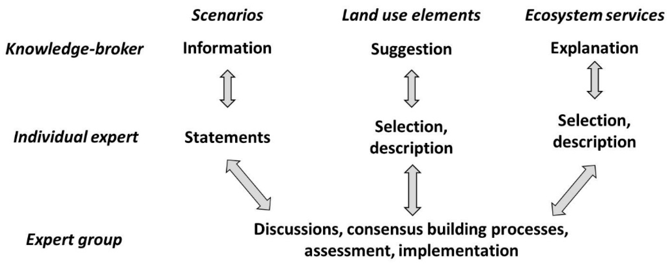
The researchers served as knowledge-broker, providing information on land management scenarios, suggestions of regionally relevant land use elements and explanation of the ecosystem services (Figure 1). Their tasks were to provide context, scientific information and decision-alternatives. Additionally, knowledge brokering included the mediation and interaction between the individual experts and the regional group as a whole, to find solutions among conflicting parties, and to create trust and joint decision-making (capacity building). The experts delivered their opinion to the different land-management scenarios, and were asked to select and describe relevant land use elements as resource units with specific ecosystem service outputs. During the whole co-design in the collaborative landscape planning process, the expert group discussed the different topics, started consensus building processes, performed assessments and implemented intermediate results in the planning process (Figure 2).
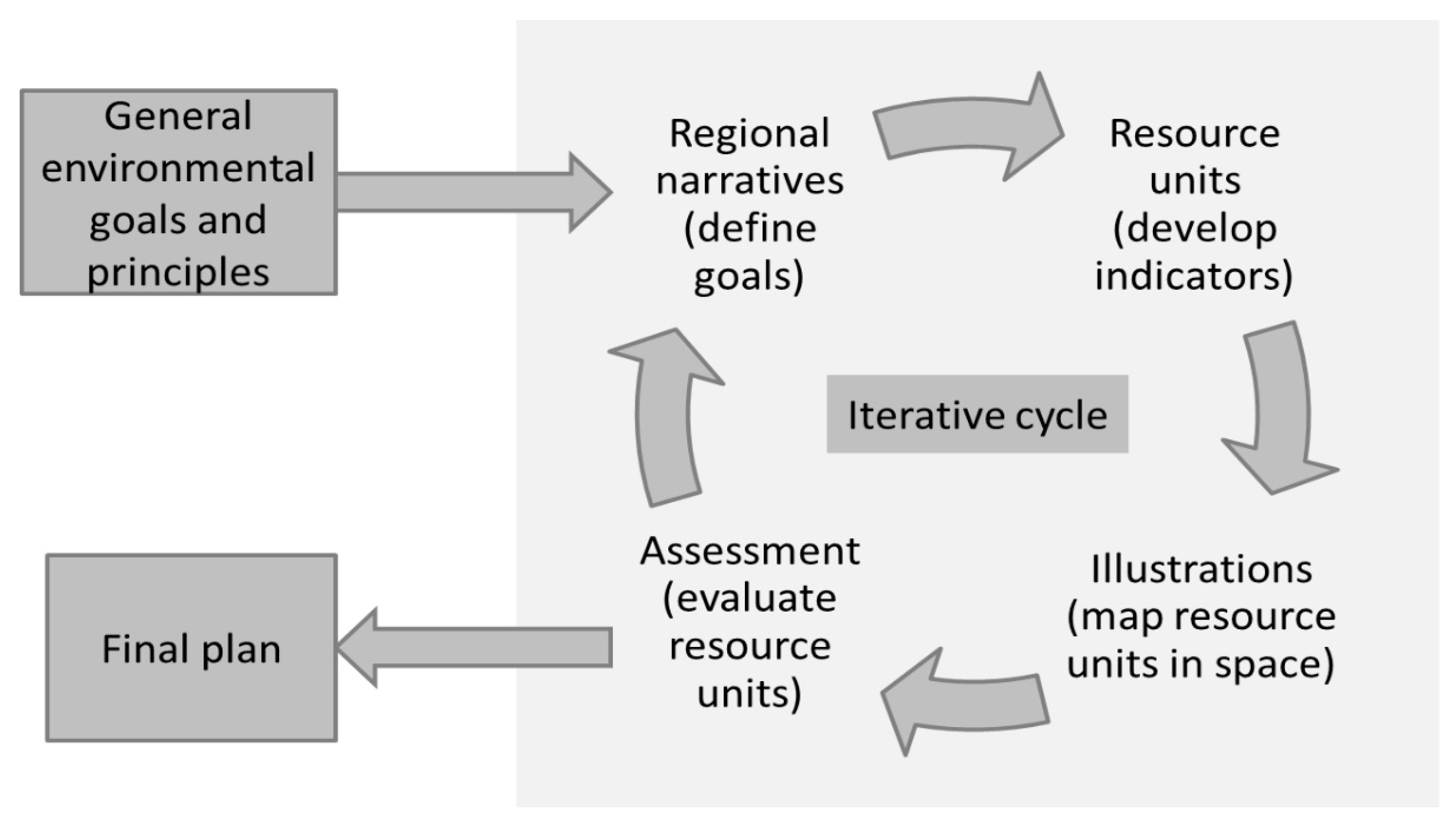
During the collaborative planning process the regional group worked closely together with the knowledge-brokers. The development of a climate adaptation strategy contained four steps iterating towards increasing detail and spatial explicitness: (1) narratives; (2) resource units; (3) illustrating maps of the different scenarios; and (4) an assessment process. These steps were characterized by multiple loops, spiraling towards increasing detail and spatial explicitness until the plan was finalized (Figure 2, for a timeline, see Supplementary Materials Table S2).
The first step in the collaborative process was the development of narratives to identify alternative options for future land management, based on general environmental goals and principles without spatial dimension. Discussing the sustainability of the current land management (“trend” scenario) was important to outline problems of future land management. The knowledge-brokers proposed two alternative land management scenarios (“water management” and “carbon sequestration”) with a focus on water retention and carbon sequestration. These scenarios were spatially explicit and allowed discussion on where to apply which land management. Semi-structured interviews with the individual experts served as a communication platform to introduce these scenarios and to obtain the expert’s opinion on them. A special focus was on the ecosystem service outputs of these scenarios as part of the ecosystem-based approach. Both scenarios were relatively far-reaching in the proposed land use change, provoking rejection among most experts and providing incentives to establish their own scenario which eventually became the final plan (“actor-based” scenario). However, the trend and the alternative scenarios were never dismissed from the planning process, but demonstrated the ideal prioritization of the status quo and of regulatory services, respectively, i.e., water retention and carbon sequestration. The narratives were discussed and mapped in focus groups (consisting of representatives of a single societal sector) and annual workshops with the regional group to guide consensus building processes.
In the second step, resource units were assessed by the experts. Firstly, a consensus list of land use elements (i.e., arable land, grassland or polder areas) was compiled. This list only contained land use elements supposed to change their spatial extension between the proposed scenarios. Likewise, a list of locally relevant ecosystem services was developed together with the regional experts. Often, local experts have only limited prior knowledge about the ecosystem services concept particularly about regulatory services [46,47]. It was the task of the knowledge-brokers to explain the concept and make it applicable. The land use elements served as easily understandable units to explain the connections between land use and ecosystem services. Land use elements and their expected ecosystem service outputs were considered as resource units to design the resource system.
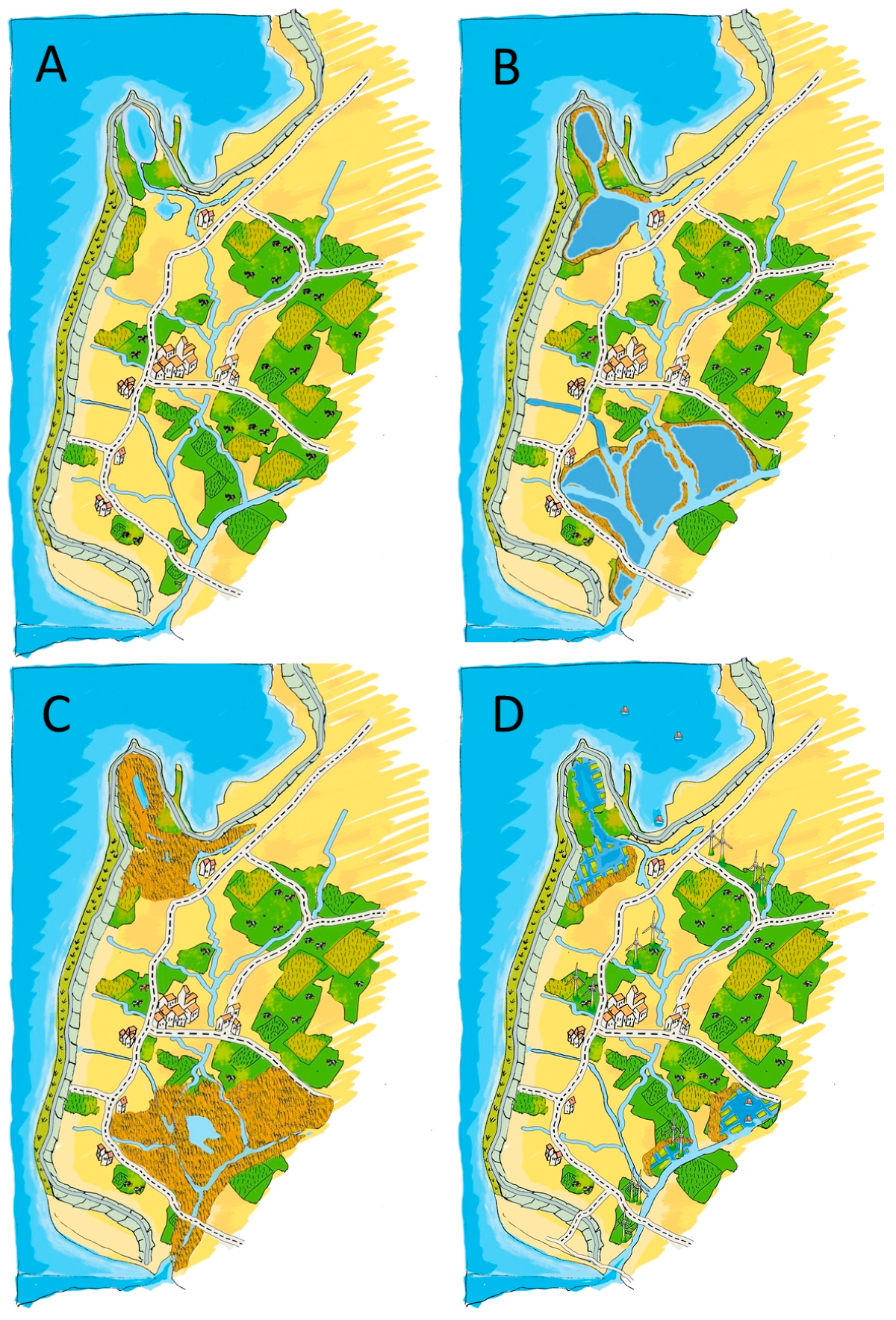
In the third step, art-based illustrations of the proposed landscape were designed to support the imagination of the experts and simplify the understanding of complex issues (Figure 3). Combined with the narratives, they were important to visualize the differences between the scenarios in an easy and well-communicable way [48,49]. Based on visualizations of the “trend”, “water management” and “carbon sequestration” scenarios, the expert group developed the “actor-based” visualization (Figure 3). Thus, the collaborative process involved participatory mapping running from initial sketches on existing topographic maps to illustrations of the main ideas and to the final map (Supplementary Materials S3).
The fourth step consisted of focus groups and workshops, in which the expert group evaluated the final land management scenarios. This interactive process ensured a cross-sectoral exchange and allowed each sector to contribute individually as well as a group. Controversial assumptions, such as the development of large polder areas to store fresh water, were discussed until consensus was reached. As result, the “actor-based” scenario was co-designed, showing consensus-based future land management for the study region.
3. Results
3.1. Collaborative Landscape Planning
Four different ecosystem-based land management scenarios were designed. Beside the “trend” scenario, two alternative land management scenarios “water management” and “carbon sequestration” suggest ecosystem-based alternatives compared to the trend scenario. The expert group designed a fourth “actor-based” scenario, which essentially was a compromise of the other scenarios.
The “trend” scenario projected the current land management into the future (Figure 3A). Food and forage production as well as recreation and tourism were the key ecosystem services generated by this scenario (Table 2). Time periods of natural freshwater discharge into the sea at ebb tide were expected to decrease due to rising sea level. Consequently, more freshwater from this area would have to be pumped into the sea. It was expected that the pumping capacity had to be strongly increased to secure the drainage of the region and to maintain the current agricultural activities. Otherwise, flood events might substantially disrupt the future land use and lead to higher drainage costs and higher economic risks for agricultural production, reducing the ecological and economic viability of this land management scenario under a changing climate. Considering the expected increase in precipitation in winter, the increased discharge needs to be managed. The Director of the Water Board Emden described the problem:
We recognize that we have reached the maximum capacity of our pumping station. The increasing frequency and intensity of rain events and the spread of impervious surfaces lead to faster water run-off. Therefore, we have to pump around the clock as we cannot wait to discharge the water during ebb tide. We experienced extreme situations in the last years. Although we used our whole pumping capacity, the hinterland could not be kept to an appropriate water level. Despite the unprecedented safety of our dike system, our drainage system just barely underwent a critical point.
To prevent the hinterland from drowning in rainwater, large fresh water storage basins (called polders) landwards of the dike were considered as an alternative to expensive investments in pumping stations and infrastructure. The “water management” option focused on water storage, leading to embanked open waters and reed stands within large polder areas (Figure 3B). The primary aim was to restrict floods to the polder areas when the drainage network is no longer capable of discharging excess freshwater. The polders aimed at increasing in particularly two regulating and maintenance services (Table 2). The water storage capacity creates a buffer for regulating natural hazards and polders filled with freshwater can prevent subsurface saltwater intrusion in the area. Nevertheless, the measures taken in this land management scenario are supposed to shift provisioning services. On the one hand, the retained freshwater in the polders might be used during dry summer periods for irrigation and the reed stands can be harvested for renewable energy generation or industrial applications (i.e., roofing material or industrial raw material [50]). On the other hand, the establishment of polder areas leads to a decrease in available land for arable fields and grasslands.
The “carbon sequestration” land management scenario (Figure 3C) is similar to the “water management” option. However, the freshwater polders will mainly be covered by reed fens instead of open water due to lower water levels. The reeds within the polder areas will not be harvested, in order to promote accumulation of organic matter and peat formation. Peat formation in wet marshes belongs to the most efficient natural processes capable of sequestering CO2 from the atmosphere [51]. Furthermore, reed fens dominated the flood-prone regions of the Wadden Sea coast before dike-building started in medieval times [52]. Within the polder, a development towards former natural vegetation is expected. This scenario increased especially regulation and maintenance ecosystem services (Table 2). Nevertheless, it may not promote a carbon-optimized land management because reeds are net sources of CO2 equivalents mainly caused by high CH4 emissions [53].
In the “actor-based” scenario (Figure 3D), the expert group proposed polder areas and a widening and strengthening of the main drainage system to prevent flooding and increase water retention (Table 2). In contrast to the other land management scenarios, they preferred rather small polders on sites without settlements or arable fields. Statements made by Director of the Dike Board Krummhörn and Director of the Water Board Emden underline the position of the group:
The need for polders to attenuate extreme situations is indisputable. We all agree about it; and In the future, we can manage excess rainwater situations with polders to prevent flooding.
Additionally, maintaining regional characteristics was considered essential and the importance of the landscape’s aesthetic values was emphasized. This implied the establishment of a mosaic of different land uses, which should increase the amenity of the region. The expert group preferred a multifunctional landscape consisting of diverse resource units, without large monocultures prioritizing a single unit:
In the future it is not possible to enforce single sided maximum claims. Different forms of land use have to be combined, and multifunctional landscapes will become more and more important.(Administrator Chamber of Agriculture)
As it is very important to find synergies, different forms of land use have to be weighed against each other to avoid conflict situations.(Administrator County of Aurich)
In the actor-based scenario, the performance of key ecosystem services increased compared to the other scenarios (Table 2), because it combined targets of both the water management and the trend scenario. The expert group viewed the carbon sequestration scenario as the least suitable for the case study region. Cultural services such as promotion of recreation, tourism and community identification were seen as essential for the development of new land management options.
3.2. Implementation
The collaborative landscape planning process applied in this case study promoted the development of an adaptation strategy to avoid future uncontrolled flooding of the coastal hinterland. The actor-based scenario represented the expert’s preferred future land management:
Small polder areas contribute to relieve the drainage system. It is definitely wise to think about the usefulness of low lying areas to serve as polders for a manageable threshold level of damage.(Director of the Water Board Emden)
The climate adaptation strategy laid out in the actor-based scenario was of great interest for the regional planning administration of the county, since all relevant societal sectors were part of the expert group that designed this scenario. As an important result of the collaborative landscape planning process, essential elements of the actor-based scenario were implemented in the regional spatial plan of the county (“Regionales Raumordnungsprogramm 2015” [41]). In particular, small polders were included in the plan, representing a strategic shift towards “water storage instead of pumping” in regional water management. The Major of the Krummhörn Municipality and Administrator of the County of Aurich agree:
With the determination of priority areas for flood protection and water storage, the county of Aurich includes the risk of storm surges and dike security, and considers the problems of the drainage system. Nowadays it is already necessary to create polders to store rainwater from extreme events. The designation of such areas took place in close collaboration with all institutions responsible for water management and coastal protection, nature conservation, and the municipality.
4. Discussion
4.1. The Co-Design Process
The complexity between environmental, social, spatial, and temporal interactions was a challenge for the communication process to understand complex social-ecological systems and progress actionable science for sustainability [39,40]. Co-design with representatives of different societal sectors showed that every decision-maker has his or her own special field of activity and individual expertise. Different worldviews, interests, and social contexts had to be considered in the evaluation process. For example, in the beginning, the experts showed little awareness of climate change and related problems such as inland flooding or saltwater intrusion:
Initially, some followed the process rather critically. But over the long term we recognized that we discussed very reasonable issues.(Director Farmer Association East Frisia)
This also became evident during the compilation of the consensus list of landscape elements and their interpretation in terms of ecosystem services. For instance, nature conservationists viewed forage production as related to actual biomass removal, groundwater level and income, whereas farmers focused on the potential of all ecosystems to produce forage, including nature reserves, where mowing and grazing is prohibited. The conservation perception of farmers was related to low land use intensity, whereas the conservationists associated it mainly with endangered meadow birds [47]. Group discussions allowed experts with partly conflicting interests, such as nature conservation and agriculture, to clarify and explain their viewpoints which supported consensus building (examples given in [54]). This issue was emphasized by several participants:
We farmers are willing to incorporate flexible nature conservation measures. Provided it is not considered from one side only, and without exclusively restricted conservation areas.(Chairman Farmer Association East Frisia)
The actor-based scenario is a compromise in terms of a nature conservationist´s viewpoint. However, small scale fragmentation leading to minimum habitats is no option.(Administrator National Park Authority)
According to Clark et al. [55], collaboration between knowledge-brokers and experts is needed to understand complex social-ecological systems. To promote a mutual relationship, cross-sectoral perspectives needed to be considered [13,56]. The experts showed openness and willingness to collectively develop a sustainable future, including compromises. To avoid conflicts, the knowledge-brokers (researchers) helped in terms of awareness raising, education, guidance, and local capacity building regarding future land management. An important task was to focus on the experts’ interests and the planning and management of opportunities [57]. Transparency during the focus groups and workshops was a way to build mutual trust and address community concerns. Working on a common goal combined with mutual learning enabled the experts to explain distinct issues to others, thus increasing mutual learning and acceptance of different world-views and ways of acting:
Every expert in the group delivered an important contribution to the process. The group work promotes a mutual understanding of different viewpoints.(Administrator Lower Nature Conservation Authority)
Designing land use management to be adaptive and sustainable was of interest to every expert in this context. Experts’ increasing awareness that a sustainable development of the community leads to increased well-being of their children, and the recognition that adaptation measures will be necessary to deal with future challenges further motivates them to work on this goal:
The inter- and transdisciplinary collaboration during this process is a precondition for sustainable development.(Administrator Biosphere Reserve Authority)
Co-design is not possible if the contributing stakeholders are not seeing the benefits of the process to participate. The experts offer their time and resources on a voluntary basis, and have to deal with “unusual” issues. Keeping the experts motivated is an important issue, and this is not a gradual process. To keep the expert´s motivation to participate on a high level, the researchers had to constantly give feedback, consider each interest in an equitable manner [34], and provide intermediate research results of scientific investigations in the area (e.g., in [47,53,58,59]). Additionally, the knowledge-brokers had to retain a non-interventionist attitude to allow the experts to take their own decisions autonomously [60]. According to Hering [60] (p. 364), knowledge brokering is an “iterative and bidirectional process of translation, tailoring of information for specific contexts, feedback, and integration”. This statement also applied to our case study. The experts always had the possibility to contribute to the planning process with their specific competences and to modify the adaptation strategy. Additionally, emphasizing that the results are an outcome of the participatory process depending on the expert-knowledge and only guided by the researchers increased the experts’ feeling of responsibility. An emphatic relationship between knowledge-brokers and experts supported the co-design process and created a trustful, creative, communicative, cooperative, participative, informative, flexible, and open-minded process which fostered successful planning [18,34,55,60].
One of the main strengths is that we brought all actors and interests together and discussed taboo topics as well.(Administrator Chamber of Agriculture)
Although it was challenging to get into future scenarios, it was an impressive experience getting the possibility to think about the probable future development of the region. Especially beyond daily business and other means. We had a lot of fun.(Director Tourism Association East Frisia)
By co-designing the ecosystem-based land management scenarios during the iterative collaborative landscape planning process, communication gaps [61] between the different land users represented by the experts from the sectors of water management, agriculture, nature conservation, regional policy and planning authorities, tourism, and science were overcome. Teamwork was essential for the design of the climate adaptation strategy [62]. To facilitate adaptive management, the process integrated research and decision-making [58] to manage change processes in the coastal social-ecological system.
4.2. Comparison of the Land Management Scenarios
Scenario planning was introduced to optimize land use patterns and to focus on the multifunctionality of land use [63]. In this study, the ecosystem-based scenarios relied on narratives from an ecological viewpoint, delivering plausible, dynamic, yet hypothetical pathways to the future. The collaborative planning processes anchored the ecosystem services concept in the SES framework [30,39] with the scenarios as alternative resource systems. Both the ecosystem services and social-ecological system frameworks rely on interactions between social and ecological subsystems [27]. The scenarios were seen as alternative resource systems composed of resource units differing in spatial extent, i.e., land use elements with their provisioning, regulatory and cultural service outputs. The governance system and the regional planning authorities set the legal rules for the individual experts that represented different users in the social-ecological system, namely the water managers, farmers, nature conservationists, and tourists.
According to the classification of the scenario characteristics described by van Notten et al. [64], the water management and carbon sequestration scenarios had an extreme character. They stimulated awareness of the issues addressed, creative thinking, and insights into ecological conditions and relationships in the case study region [64]. By prioritizing regulating services, they also represented a strong contrast to the trend scenario that prioritized agricultural production and (provisioning services). It had a normative character, as it described a preferable future, including sectoral preferences, needs, and expectations, from the perspectives of the experts. During the research process, it became obvious that local thinking and acting in the case study area followed traditional adaptation measures. The transitions from fighting against water towards living with water (see [65,66]), were not yet attained. Nevertheless, the experts recognized that simply following the current trend might increase landscape vulnerability caused by climate change. In the experts’ view, the sustainable use of land is increasingly important and consideration of provisioning ecosystem services such as food, forage and freshwater becomes more important for decision-making processes [67]. Carpenter et al. [68] state that regulating ecosystem services are often not well considered in decision-making processes. As a consequence of the vast changes in the water management expressed in the water management and carbon sequestration scenarios drafted by the researchers, the experts’ attention towards regulating ecosystem services was raised and ultimately considered vital for landscape planning.
The collaborative landscape planning process led to the implementation of the actor-based scenario in the formal regional spatial plan of the county [41]. Such case studies transformed into real plans are important to bridge the gap between science and policy-making [34,35] and strengthen the impact of ecosystem services research [18,33,37]. This study shows a comprehensive stakeholder engagement process bridging the science-policy gap and including an ecosystem-based management in the implementation of planning activities [17,27,36].
5. Conclusions
Our study showed that innovative ways of land management to maintain productive land use and reduce the vulnerability to impacts of climate change and sea level rise can be found in collaborative landscape planning. The collaborative landscape planning process supports decision-making in a regional context to manage land use in a sustainable and adaptive way, and enables experts to deal with the challenges of climate and anthropogenic change processes. The co-design of ecosystem-based land management scenarios illustrated human and nature relationships and enabled the regional group to deal with socio-ecological and spatio-temporal interactions. The iterative and step-wise approach consisted of:
- -
- developing narratives, telling the different stories how the future of the case study region could be designed for the future, and transforming them into spatially explicit scenarios;
- -
- conceiving resource units as land use elements with specific ecosystem service outputs and scenarios as resource systems with characteristic spatial patterns of resource units;
- -
- employing participatory mapping including simple illustrations to foster creativity and understanding; and
- -
- guiding an assessment process to evaluate the outcomes leading to the design of a final landscape plan.
In comparison to the traditional linear planning procedure (screening, inventory, assessment, and planning), the knowledge-brokers mediated and supervised a collaborative process. This process involved multiple feedback loops between knowledge-brokers and regional experts, and evolved from disparate sector-oriented statements towards increasing consensus and spatial detail.
Based on the scenarios, it was possible to define long-term consequences for planning and actions in regional land use management, and raise the awareness of the advantages of an ecosystem-based management. Providing water retention polders currently not established in the case study region could prevent sites below sea level from drowning in rainwater. These polders were proposed as an alternative to expensive investments in pumping capacity and to strengthen regulating services. The iterative collaborative landscape planning process contributed to the implementation of a climate adaptation strategy in formal regional planning. Our case study showed the potential of collaborative landscape planning processes to deal with challenges of spatial planning by transferring informal planning designs into formal ones.
Supplementary Materials
The following are available online at www.mdpi.com/2071-1050/9/9/1668/s1, Table S1: Ecosystem services considered in this study, Table S2: Timeline, Supplementary Materials S3: Example participatory mapping: Development of spatially explicit land management scenarios.
Acknowledgments
The development of the actor-based scenario was only possible with the active participation of the experts. We are thankful for the time and effort they spent during the research process. We would also like to thank Udo Schotten for drawing the land management scenarios (Figure 3). This project was part of the collaborative research project “Sustainable coastal land management: Trade-offs in ecosystem services” (COMTESS), supported by the German Federal Ministry of Education and Research (grant number 01LL0911).
Author Contributions
All authors conceived and designed the study; Leena Karrasch performed the study; Leena Karrasch and Thomas Klenke analyzed the data; Martin Maier and Michael Kleyer contributed data; Leena Karrasch wrote the paper with contributions from all other authors.
Conflicts of Interest
The authors declare no conflict of interest.
References
- Reise, K. Coast of change: Habitat loss and transformations in the Wadden Sea. Helgol. Mar. Res. 2005, 59, 9–21. [Google Scholar] [CrossRef]
- Parker, D.C.; Hessl, A.; Davis, S.C. Complexity, land-use modeling, and the human dimension: Fundamental challenges for mapping unknown outcome spaces. Geoforum 2008, 39, 789–804. [Google Scholar] [CrossRef]
- Viglizzo, E.F.; Paruelo, J.M.; Laterra, P.; Jobbágy, E.G. Ecosystem service evaluation to support land-use policy. Agric. Ecosyst. Environ. 2012, 154, 78–84. [Google Scholar] [CrossRef]
- Kerselaers, E.; Rogge, E.; Vanempten, E.; Lauwers, L.; Van Huylenbroeck, G. Changing land use in the countryside: Stakeholders’ perception of the ongoing rural planning processes in Flanders. Land Use Policy 2013, 32, 197–206. [Google Scholar] [CrossRef]
- Elliott, M.; Cutts, N.D.; Trono, A. A typology of marine and estuarine hazards and risks as vectors of change: A review for vulnerable coasts and their management. Ocean Coast. Manag. 2014, 93, 88–99. [Google Scholar] [CrossRef]
- Pachauri, R.K.; Allen, M.R.; Barros, V.R.; Broome, J.; Cramer, W.; Christ, R.; Church, J.A.; Clarke, L.; Dahe, Q.; Dasgupta, P. Climate Change 2014: Synthesis Report; Contribution of Working Groups I, II and III to the Fifth Assessment Report of the Intergovernmental Panel on Climate Change; IPCC: Geneva, Switzerland, 2014. [Google Scholar]
- Alcamo, J.; Moreno, J.M.; Shvidenko, A. Europe. Climate Change 2007: Impacts, Adaptation and Vulnerability. Available online: https://www.ipcc.ch/pdf/assessment-report/ar4/wg2/ar4-wg2-chapter12.pdf (accessed on 18 September 2017).
- Weisse, R.; Von Storch, H.; Niemeyer, H.D.; Knaack, H. Changing north sea storm surge climate: An increasing hazard? Ocean Coast. Manag. 2012, 68, 58–68. [Google Scholar] [CrossRef]
- Jacob, D.; Göttel, H.; Kotlarski, S.; Lorenz, P.; Sieck, K. Klimaauswirkungen und Anpassung in Deutschland—Phase 1: Erstellung Regionaler Klimaszenarien für Deutschland; Umweltbundesamt: Dessau-Roßlau, Germany, 2008. [Google Scholar]
- Spekat, A.; Enke, W.; Kreienkamp, F. Neuentwicklung von Regional Hoch Aufgelösten Wetterlagen für Deutschland und Bereitstellung Regionaler Klimaszenarios auf der Basis von Globalen Klimasimulationen mit dem Regionalisierungsmodell WETTREG auf der Basis von Globalen Klimasimulationen mit EECHAM5/MPI-OM T63L31 2010 bis 2100 für die SRESSzenarios B1, A1B und A2; Umweltbundesamt: Dessau-Roßlau, Germany, 2007. [Google Scholar]
- Oude Essink, G.H.P.; Van Baaren, E.S.; De Louw, P.G.B. Effects of climate change on coastal groundwater systems: A modeling study in the Netherlands. Water Resour. Res. 2010, 46, 10. [Google Scholar] [CrossRef]
- Blotevogel, H.H.; Danielzyk, R.; Münter, A. Spatial planning in Germany: Institutional inertia and new challenges. In Spatial Planning Systems and Practices in Europe: A Comparative Perspective on Continuity and Changes; Reimer, M., Getimis, P., Blotevogel, H.H., Eds.; Routledge: New York, NY, USA, 2014; pp. 83–108. [Google Scholar]
- Opdam, P. Using ecosystem services in community-based landscape planning: Science is not ready to deliver. In Landscape Ecology for Sustainable Environment and Culture; Springer: Berlin, Germany, 2013; pp. 77–101. [Google Scholar]
- Opdam, P.; Nassauer, J.I.; Wang, Z.; Albert, C.; Bentrup, G.; Castella, J.C.; McAlpine, C.; Liu, J.; Sheppard, S.; Swaffield, S. Science for action at the local landscape scale. Landsc. Ecol. 2013, 28, 1439–1445. [Google Scholar] [CrossRef]
- Carlsson, L.; Berkes, F. Co-management: Concepts and methodological implications. J. Environ. Manag. 2005, 75, 65–76. [Google Scholar] [CrossRef] [PubMed]
- Folke, C.; Hahn, T.; Olsson, P.; Norberg, J. Adaptive governance of social-ecological systems. Ann. Rev. Environ. Resour. 2005, 30, 441–473. [Google Scholar] [CrossRef]
- Fürst, C.; Opdam, P.; Inostroza, L.; Luque, S. Evaluating the role of ecosystem services in participatory land use planning: Proposing a balanced score card. Landsc. Ecol. 2014, 29, 1435–1446. [Google Scholar] [CrossRef]
- Posner, S.M.; McKenzie, E.; Ricketts, T.H. Policy impacts of ecosystem services knowledge. Proc. Natl. Acad. Sci. USA 2016, 113, 1760–1765. [Google Scholar] [CrossRef] [PubMed]
- Rounsevell, M.D.A.; Metzger, M.J. Developing qualitative scenario storylines for environmental change assessment. Wiley Interdiscip. Rev. Clim. Chang. 2010, 1, 606–619. [Google Scholar] [CrossRef]
- Thompson, J.R.; Wiek, A.; Swanson, F.J.; Carpenter, S.R.; Fresco, N.; Hollingsworth, T.; Spies, T.A.; Foster, D.R. Scenario studies as a synthetic and integrative research activity for long-term ecological research. BioScience 2012, 62, 367–376. [Google Scholar] [CrossRef]
- Albert, C.; Aronson, J.; Fürst, C.; Opdam, P. Integrating ecosystem services in landscape planning: Requirements, approaches, and impacts. Landsc. Ecol. 2014, 29, 1277–1285. [Google Scholar] [CrossRef]
- Millennium Ecosystem Assessment. Ecosystems and Human Well-Being: A Framework for Assessment; Island Press: Washington, DC, USA, 2003. [Google Scholar]
- UK National Ecosystem Assessment. The UK National Ecosystem Assessment Follow-On: Synthesis of the Key Findings; UNEP-WCMC: Cambridge, UK, 2014. [Google Scholar]
- Opdam, P.; Coninx, I.; Dewulf, A.; Steingröver, E.; Vos, C.; Van der Wal, M. Framing ecosystem services: Affecting behaviour of actors in collaborative landscape planning? Land Use Policy 2015, 46, 223–231. [Google Scholar] [CrossRef]
- Peterson, G.D.; Cumming, G.S.; Carpenter, S.R. Scenario planning: A tool for conservation in an uncertain world. Conserv. Biol. 2003, 17, 358–366. [Google Scholar] [CrossRef]
- Long, R.D.; Charles, A.; Stephenson, R.L. Key principles of marine ecosystem-based management. Mar. Policy 2015, 57, 53–60. [Google Scholar] [CrossRef]
- Partelow, S.; Winkler, K.J. Interlinking ecosystem services and ostrom’s framework through orientation in sustainability research. Ecol. Soc. 2016, 21, 3. [Google Scholar] [CrossRef]
- Smythe, T.C.; Thompson, R. Conceptualizing coastal ecosystem-based management: A mental models approach. Soc. Nat. Resour. 2014, 28, 38–56. [Google Scholar] [CrossRef]
- Haines-Young, R.; Potschin, M. Consultation on Cices Version 4, August–December 2012. Report to the European Environment Agency, EEA Framework Contract No: EEA/IEA/09/003. Available online: http://unstats.un.org/unsd/envaccounting/seearev/GCComments/CICES_Report.pdf (accessed on 9 August 2013).
- Ostrom, E. A general framework for analyzing sustainability of social-ecological systems. Science 2009, 325, 419–422. [Google Scholar] [CrossRef] [PubMed]
- Grothmann, T.; Petzold, M.; Ndaki, P.; Kakembo, V.; Siebenhüner, B.; Kleyer, M.; Yanda, P.; Ndou, N. Vulnerability assessment in african villages under conditions of land use and climate change: Case studies from Mkomazi and Keiskamma. Sustainability 2017, 9, 976. [Google Scholar] [CrossRef]
- Epstein, G.; Vogt, J.; Mincey, S.; Cox, M.; Fischer, B. Missing ecology: Integrating ecological perspectives with the social-ecological system framework. Int. J. Commons 2013, 7, 432–453. [Google Scholar] [CrossRef]
- De Groot, R.S.; Alkemade, R.; Braat, L.; Hein, L.; Willemen, L. Challenges in integrating the concept of ecosystem services and values in landscape planning, management and decision making. Ecol. Complex. 2010, 7, 260–272. [Google Scholar] [CrossRef]
- Bennett, E.M.; Cramer, W.; Begossi, A.; Cundill, G.; Díaz, S.; Egoh, B.N.; Geijzendorffer, I.R.; Krug, C.B.; Lavorel, S.; Lazos, E. Linking biodiversity, ecosystem services, and human well-being: Three challenges for designing research for sustainability. Curr. Opin. Environ. Sustain. 2015, 14, 76–85. [Google Scholar] [CrossRef]
- Reyers, B.; Biggs, R.; Cumming, G.S.; Elmqvist, T.; Hejnowicz, A.P.; Polasky, S. Getting the measure of ecosystem services: A social—Ecological approach. Front. Ecol. Environ. 2013, 11, 268–273. [Google Scholar] [CrossRef]
- Eppink, F.V.; Werntze, A.; Mäs, S.; Popp, A.; Seppelt, R. Land management and ecosystem services how collaborative research programmes can support better policies. GAIA Ecol. Perspect. Sci. Soc. 2012, 21, 55–63. [Google Scholar] [CrossRef]
- McKenzie, E.; Posner, S.; Tillmann, P.; Bernhardt, J.R.; Howard, K.; Rosenthal, A. Understanding the use of ecosystem service knowledge in decision making: Lessons from international experiences of spatial planning. Environ. Plan. C Gov. Policy 2014, 32, 320–340. [Google Scholar] [CrossRef]
- Miller, T.R.; Wiek, A.; Sarewitz, D.; Robinson, J.; Olsson, L.; Kriebel, D.; Loorbach, D. The future of sustainability science: A solutions-oriented research agenda. Sustain. Sci. 2014, 9, 239–246. [Google Scholar] [CrossRef]
- McGinnis, M.; Ostrom, E. Social-ecological system framework: Initial changes and continuing challenges. Ecol. Soc. 2014, 19, 2. [Google Scholar] [CrossRef]
- Partelow, S. Coevolving ostrom’s social—Ecological systems (ses) framework and sustainability science: Four key co-benefits. Sustain. Sci. 2016, 11, 399–410. [Google Scholar] [CrossRef]
- Landkreis Aurich. Regionales Raumordnungsprogramm 2015: Beschreibende Darstellung—Entwurf; Landkreis Aurich: Lower Saxony, Germany, 2015. [Google Scholar]
- Rabionet, S.E. How I learned to design and conduct semi-structured interviews: An ongoing and continuous journey. Qual. Rep. 2011, 16, 563. [Google Scholar]
- Mayring, P. Qualitative Content Analysis: Theoretical Foundation, Basic Procedures and Software Solution. Available online: http://www.ssoar.info/ssoar/bitstream/handle/document/39517/ssoar-2014-mayring-Qualitative_content_analysis_theoretical_foundation.pdf (accessed on 18 September 2017).
- Colucci, E. “Focus groups can be fun”: The use of activity-oriented questions in focus group discussions. Qual. Health Res. 2007, 17, 1422–1433. [Google Scholar] [CrossRef] [PubMed]
- Innes, J.E.; Booher, D.E. Consensus building and complex adaptive systems: A framework for evaluating collaborative planning. J. Am. Plan. Assoc. 1999, 65, 412–423. [Google Scholar] [CrossRef]
- Karrasch, L.; Klenke, T.; Woltjer, J. Linking the ecosystem services approach to social preferences and needs in integrated coastal land use management—A planning approach. Land Use Policy 2014, 38, 522–532. [Google Scholar] [CrossRef]
- Cebrián-Piqueras, M.A.; Karrasch, L.; Kleyer, M. Coupling stakeholder assessments of ecosystem services with biophysical ecosystem properties reveals importance of social contexts. Ecosyst. Serv. 2017, 23, 108–115. [Google Scholar] [CrossRef]
- Bennett, N.J.; Blythe, J.; Tyler, S.; Ban, N.C. Communities and change in the anthropocene: Understanding social-ecological vulnerability and planning adaptations to multiple interacting exposures. Reg. Environ. Chang. 2015, 16, 907–926. [Google Scholar] [CrossRef]
- Millennium Ecosystem Assessment. Ecosystems and Human Well-Being. Available online: https://islandpress.org/author/millennium-ecosystem-assessment (accessed on 18 September 2017).
- Wichtmann, W. Nutzung von Schilf (phragmites australis). Arch. Naturschutz Landschaftsforsch. 1999, 38, 217–232. [Google Scholar]
- Brix, H.; Sorrell, B.K.; Lorenzen, B. Are phragmites-dominated wetlands a net source or net sink of greenhouse gases? Aquat. Bot. 2001, 69, 313–324. [Google Scholar] [CrossRef]
- Behre, K.E. Coastal development, sea-level change and settlement history during the later holocene in the clay district of lower saxony (niedersachsen), northern Germany. Quat. Int. 2004, 112, 37–53. [Google Scholar] [CrossRef]
- Witte, S.; Giani, L. Greenhouse gas emission and balance of marshes at the southern north sea coast. Wetlands 2016, 36, 121–132. [Google Scholar] [CrossRef]
- Karrasch, L. Matching an ecosystem services approach with social impact assessment. In Handbook on Biodiversity and Ecosystem Services in Impact Assessment; Geneletti, D., Ed.; Edward Elgar Publishing: Cheltenham, UK, 2016; pp. 86–112. [Google Scholar]
- Clark, W.C.; Van Kerkhoff, L.; Lebel, L.; Gallopin, G.C. Crafting usable knowledge for sustainable development. Proc. Natl. Acad. Sci. USA 2016, 113, 4570–4578. [Google Scholar] [CrossRef] [PubMed]
- Cash, D.W.; Clark, W.C.; Alcock, F.; Dickson, N.M.; Eckley, N.; Guston, D.H.; Jäger, J.; Mitchell, R.B. Knowledge systems for sustainable development. Proc. Natl. Acad. Sci. USA 2003, 100, 8086–8091. [Google Scholar] [CrossRef] [PubMed]
- Rijke, J.; Brown, R.; Zevenbergen, C.; Ashley, R.; Farrelly, M.; Morison, P.; van Herk, S. Fit-for-purpose governance: A framework to make adaptive governance operational. Environ. Sci. Policy 2012, 22, 73–84. [Google Scholar] [CrossRef]
- Cebrián-Piqueras, M.A.; Trinogga, J.; Grande, C.; Minden, V.; Maier, M.; Kleyer, M. Interactions between ecosystem properties and land use clarify spatial strategies to optimize trade-offs between agriculture and species conservation. Int. J. Biodivers. Sci. Ecosyst. Serv. Manag. 2017, 13, 53–66. [Google Scholar] [CrossRef]
- Minden, V.; Scherber, C.; Piqueras, M.A.C.; Trinogga, J.; Trenkamp, A.; Mantilla-Contreras, J.; Lienin, P.; Kleyer, M. Consistent drivers of plant biodiversity across managed ecosystems. Philos. Trans. R. Soc. B 2016, 371, 1694. [Google Scholar] [CrossRef] [PubMed]
- Hering, J.G. Do we need “more research” or better implementation through knowledge brokering? Sustain. Sci. 2016, 11, 363–369. [Google Scholar] [CrossRef]
- Sanders, E.B.N.; Stappers, P.J. Co-creation and the new landscapes of design. CoDesign 2008, 4, 5–18. [Google Scholar] [CrossRef]
- Nyberg, J.B. Adaptive Management: Strategies for Coping with Change and Uncertainty. Available online: http://www.eolss.net (accessed on 21 June 2017).
- Seppelt, R.; Lautenbach, S.; Volk, M. Identifying trade-offs between ecosystem services, land use, and biodiversity: A plea for combining scenario analysis and optimization on different spatial scales. Curr. Opin. Environ. Sustain. 2013, 5, 458–463. [Google Scholar] [CrossRef]
- Van Notten, P.W.F.; Rotmans, J.; van Asselt, M.B.A.; Rothman, D.S. An updated scenario typology. Futures 2003, 35, 423–443. [Google Scholar] [CrossRef]
- Stead, D. Urban planning, water management and climate change strategies: Adaptation, mitigation and resilience narratives in the netherlands. Int. J. Sustain. Dev. World Ecol. 2013, 21, 15–27. [Google Scholar] [CrossRef]
- Van der Brugge, R.; Rotmans, J.; Loorbach, D. The transition in dutch water management. Reg. Environ. Chang. 2005, 5, 164–176. [Google Scholar] [CrossRef]
- Malinga, R.; Gordon, L.J.; Lindborg, R.; Jewitt, G. Using participatory scenario planning to identify ecosystem services in changing landscapes. Ecol. Soc. 2013, 18, 4. [Google Scholar] [CrossRef]
- Carpenter, S.; Bennett, E.; Peterson, G. Scenarios for ecosystem services: An overview. Ecol. Soc. 2006, 11, 1. [Google Scholar] [CrossRef]
Figure 1.
Co-design in collaborative landscape planning.

Figure 2.
Iterative collaborative landscape planning process to co-design ecosystem-based land management scenarios.
Figure 2.
Iterative collaborative landscape planning process to co-design ecosystem-based land management scenarios.

Figure 3.
Art-based illustrations of the co-designed land management scenarios: (A) trend; (B); water management; (C) carbon sequestration; and (D) actor-based.
Figure 3.
Art-based illustrations of the co-designed land management scenarios: (A) trend; (B); water management; (C) carbon sequestration; and (D) actor-based.

Table 1.
Composition of the regional group. The 14 experts work on a regional or local level and in different organizations representing the sectors water management, nature conservation, agriculture, policy and tourism.
Table 1.
Composition of the regional group. The 14 experts work on a regional or local level and in different organizations representing the sectors water management, nature conservation, agriculture, policy and tourism.
| Sector | Expert | Organization | Level |
|---|---|---|---|
| Water management | Engineer | Water Board Emden | Autonomous public corporation (local) |
| Director | Water Board Emden | Autonomous public corporation (local) | |
| Director | Dike Board Krummhörn | Autonomous public corporation (local) | |
| Nature conservation | Administrator | National Park Authority, Lower Saxony | State authority (regional) |
| Administrator | Biosphere Reserve Authority, Lower Saxony | State authority (regional) | |
| Administrator | Lower Nature Conservation Authority | Autonomous public corporation (regional) | |
| Agriculture | Director | Farmer Association East Frisia | Registered association (regional) |
| Chairman | Farmer Association East Frisia | Registered association (local) | |
| Administrator | Chamber of Agriculture, Lower Saxony | Autonomous public corporation (regional) | |
| Policy | Major | Krummhörn Municipality | State authority (local) |
| Coordinator | State Estate Agency, Norden | State authority (regional) | |
| Administrator | County of Aurich | Public corporation (regional) | |
| Government administrator | Krummhörn Municipality | Public corporation (regional) | |
| Tourism | Director | Tourism Association East Frisia | Independent limited liability company (local) |
Table 2.
Land management scenarios and associated resource units (land use elements and key ecosystem services; ecosystem services classification according to [29]).
Table 2.
Land management scenarios and associated resource units (land use elements and key ecosystem services; ecosystem services classification according to [29]).
| Land Management Scenario | Land Use Elements | Change in Spatial Distribution | Key Ecosystem Services (Classification) | Land Use Change |
|---|---|---|---|---|
| Trend | Pumping stations | Increase | Food production (provisioning) Forage production (provisioning) Recreation and tourism (cultural) | None |
| Embankments for polder | No embankments | |||
| Arable land | No change | |||
| Grassland, intensive use | Increase | |||
| Drainage system | No change | |||
| Peat areas | No peat areas | |||
| Polder areas | No polder areas | |||
| Water management | Pumping stations | No change | Biomass for energy (provisioning) Freshwater (provisioning) Hazard regulation by water retention (regulation and maintenance) Prevention of saltwater intrusion (regulation and maintenance) | Development of a large freshwater polder |
| Embankments for polder | Increase | |||
| Arable land | Decrease | |||
| Grassland, intensive use | Decrease | |||
| Drainage system | Adaptation with polder areas | |||
| Peat areas | Adaptation with polder areas | |||
| Polder areas | Large polder areas in low-lying areas | |||
| Carbon sequestration | Pumping stations | No change | Reduction of greenhouse gases (regulation and maintenance) Hazard regulation by water retention (regulation and maintenance) Prevention of saltwater intrusion (regulation and maintenance) | Development of a freshwater polder with rich reed stands Development towards natural former vegetation |
| Embankments for polder | Increase | |||
| Arable land | Decrease | |||
| Grassland, intensive use | Decrease | |||
| Drainage system | Adaptation with polder areas | |||
| Peat areas | Large peat areas in low-lying areas | |||
| Polder areas | Peat areas serving as polders | |||
| Actor-based | Pumping stations | No change | Food production (provisioning) Forage production (provisioning) Freshwater (provisioning) Hazard regulation by water retention (regulation and maintenance) Prevention of saltwater intrusion (regulation and maintenance) Recreation and tourism (cultural) Community identification (cultural) | Development of small freshwater polder Multifunctional land use |
| Embankments for polder | Small increase | |||
| Arable land | No change | |||
| Grassland, intensive use | Decrease | |||
| Drainage system | Adaptation with polder areas | |||
| Peat areas | No peat areas | |||
| Polder areas | Small polder areas in low-lying areas |
© 2017 by the authors. Licensee MDPI, Basel, Switzerland. This article is an open access article distributed under the terms and conditions of the Creative Commons Attribution (CC BY) license (http://creativecommons.org/licenses/by/4.0/).
Share and Cite
MDPI and ACS Style
Karrasch, L.; Maier, M.; Kleyer, M.; Klenke, T. Collaborative Landscape Planning: Co-Design of Ecosystem-Based Land Management Scenarios. Sustainability 2017, 9, 1668. https://doi.org/10.3390/su9091668
AMA Style
Karrasch L, Maier M, Kleyer M, Klenke T. Collaborative Landscape Planning: Co-Design of Ecosystem-Based Land Management Scenarios. Sustainability. 2017; 9(9):1668. https://doi.org/10.3390/su9091668
Chicago/Turabian StyleKarrasch, Leena, Martin Maier, Michael Kleyer, and Thomas Klenke. 2017. "Collaborative Landscape Planning: Co-Design of Ecosystem-Based Land Management Scenarios" Sustainability 9, no. 9: 1668. https://doi.org/10.3390/su9091668
Note that from the first issue of 2016, this journal uses article numbers instead of page numbers. See further details here.