Decadal Variations in NDVI and Food Production in India

 ,
, 
Abstract
:1. Introduction
2. Data and Methods
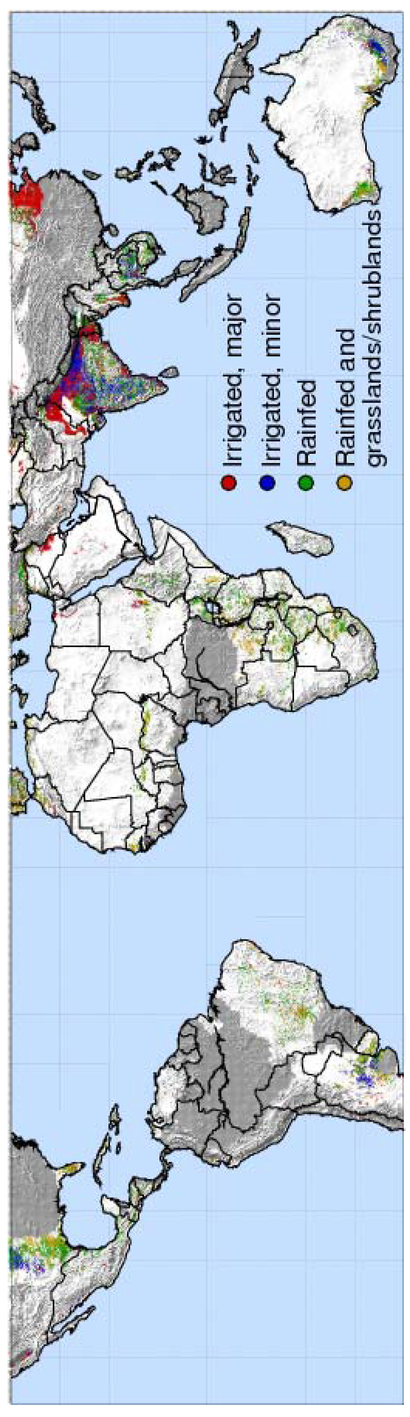
2.1. Study Region
2.2. Food Production Statistics
2.3. Climate Data
2.4. NDVI Data
2.5. Estimation of Relative Increase in Water Consumption Due to Increased Rabi Crop Production
3. Results and Discussion
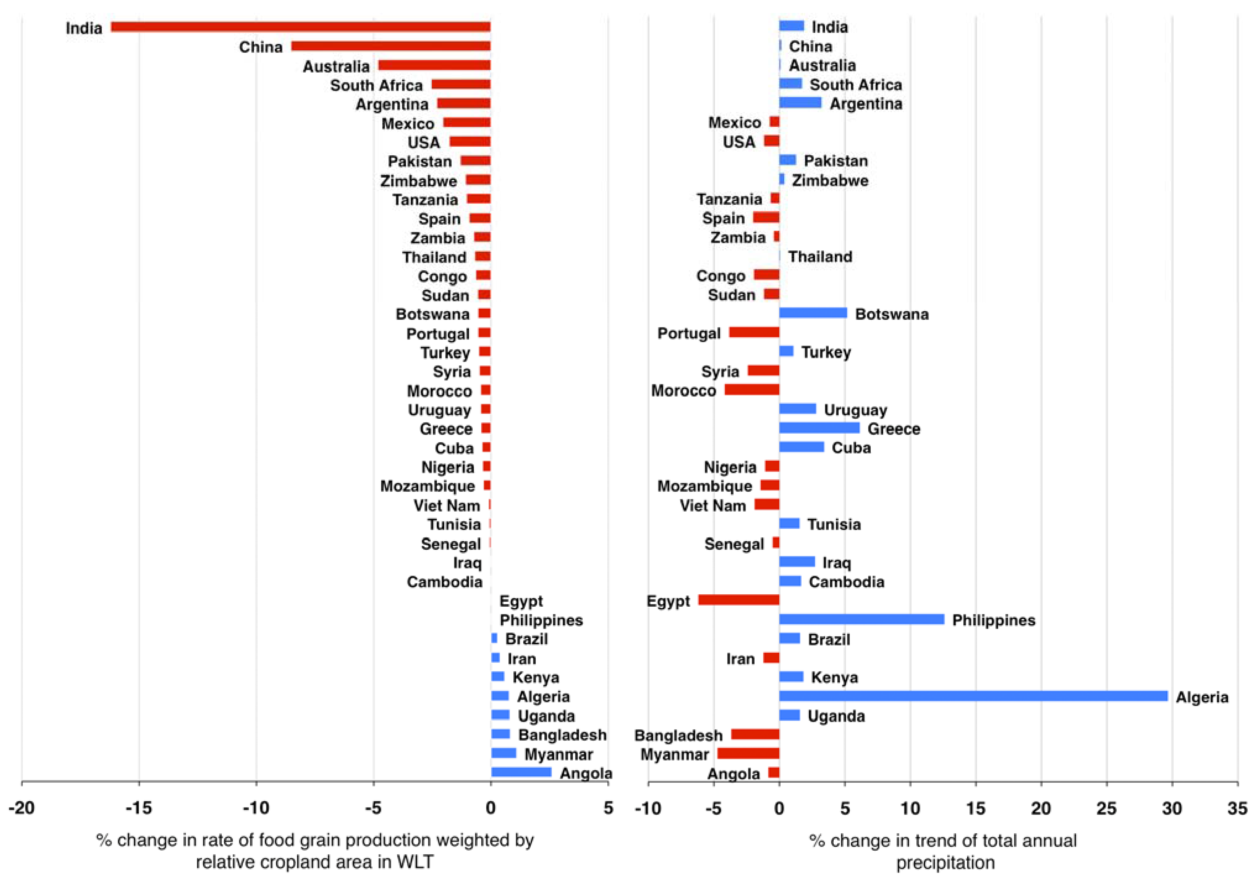
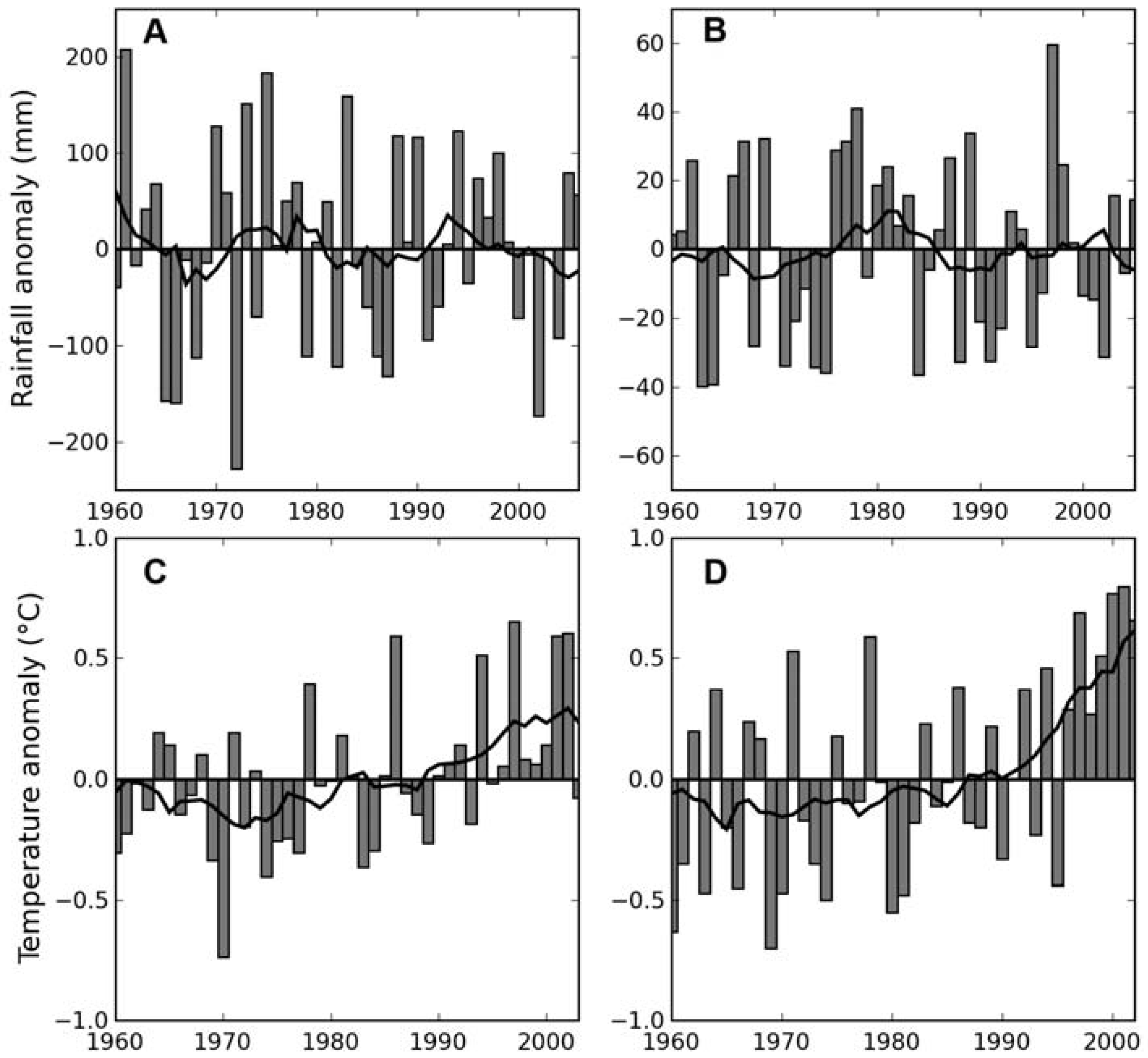
3.1. Patterns of Decline in Food Grain Production Growth Rates in the WLT

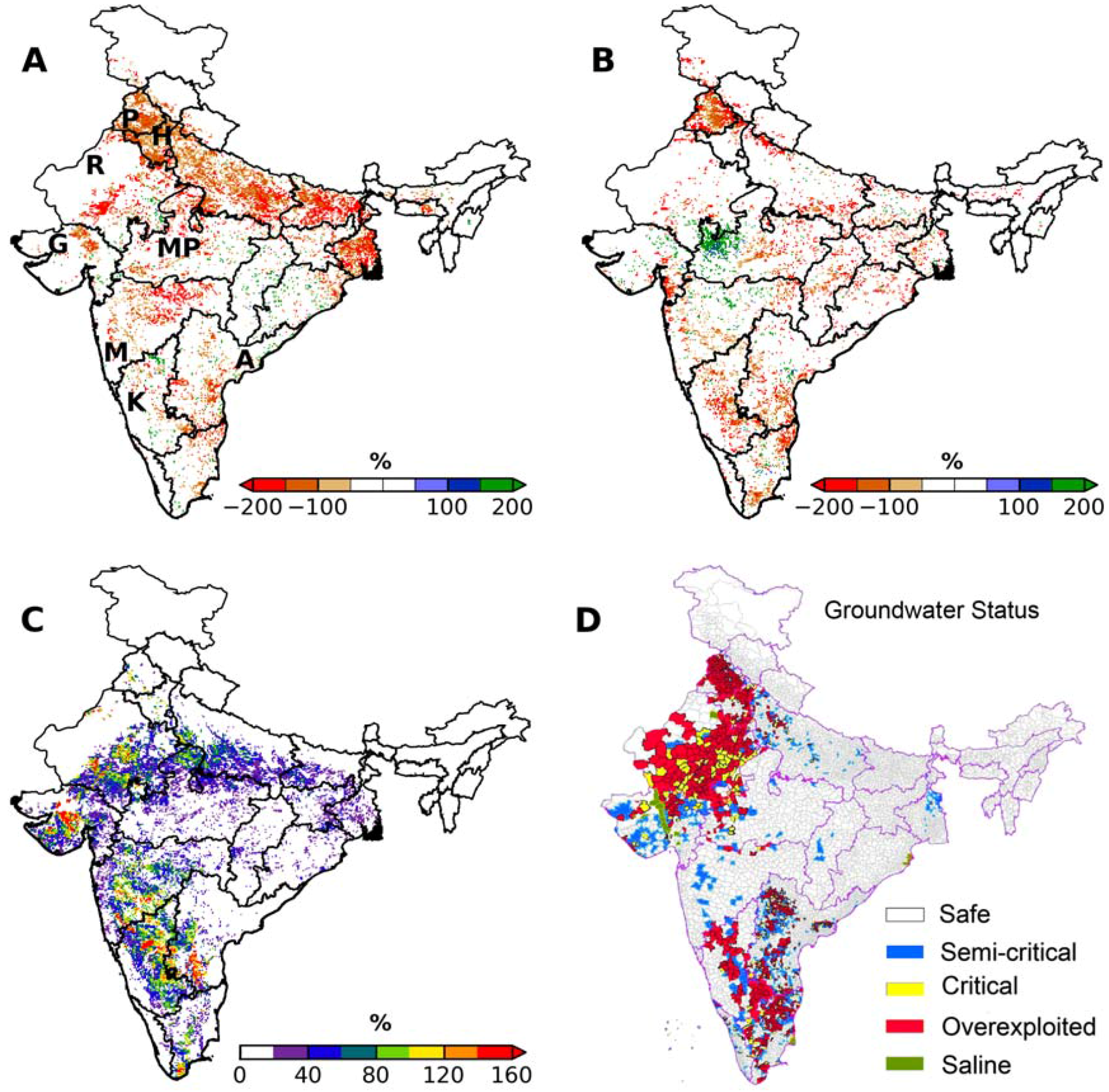
3.2. Decline in Food Grain Production Growth Rates in India


3.3. Climatic and Land Use Drivers of Declining Growth Rates
4. Conclusion
Acknowledgements
References and Notes
- Matson, P.; Parton, W.; Power, A.; Swift, M. Agricultural intensification and ecosystem properties. Science 1997, 277, 504–509. [Google Scholar] [CrossRef] [PubMed]
- WRI. EarthTrends: Land: Irrigated Land, 2007. Available online: http://earthtrends.wri.org/searchable_db/index.php?step=countries&ccID%5B%5D=0&theme=8&variable_ID=195&action=select_years (accessed on 8 August, 2009).
- Cassman, K.G. Ecological intensification of cereal production systems: yield potential, soil quality, and precision agriculture. Proc. Natl. Acad. Sci. U.S.A. 1999, 96, 5952–5959. [Google Scholar] [CrossRef] [PubMed]
- Falkenmark, M.; Rockström, J.; Karlberg, L. Present and future water requirements for feeding humanity. Food Security 2009, 1, 59–69. [Google Scholar] [CrossRef]
- Climate Change 2007: Impacts, Adaptation and Vulnerability; Contribution of Working Group II to the Fourth Assessment Report of the Intergovernmental Panel on Climate Change; Parry, M.L.; Canziani, O.F.; Palutikof, J.P.; van der Linden, P.J.; Hanson, C.E. (Eds.) Cambridge University Press: Cambridge, UK, 2007.
- The World Bank Group. Millennium Development Goals. 2004. Available online: http://ddp-ext.worldbank.org/ext/GMIS/home.do?siteId=2 (accessed on 10 January, 2010).
- FAOSTAT, FAO Statistical Databases; Food and Agriculture Organization of the United Nations: Rome, Italy, 2009; Available online: http://faostat.fao.org. (accessed on 2 March, 2009).
- Funk, C.C.; Brown, M.E. Declining global per capita agricultural production and warming oceans threaten food security. Food Security 2009, 1, 271–289. [Google Scholar] [CrossRef]
- Kumar, M.; Monteith, J. Remote sensing of plant growth. In Plants and the Daylight Spectrum; Smith, H., Ed.; Academic: London, UK, 1982; pp. 133–144. [Google Scholar]
- Kogan, F.N. Global drought watch from space. Bull. Amer. Meteorol. Soc. 1997, 78, 621–636. [Google Scholar] [CrossRef]
- Lobell, D.B.; Asner, G.P.; Ortiz-Monasterio, J.I.; Benning, T.L. Remote sensing of regional crop production in the Yaqui Valley, Mexico: estimates and uncertainties. Agr. Ecosyst. Environ. 2003, 94, 205–220. [Google Scholar] [CrossRef]
- Hatfield, J.L. Remote sensing estimators of potential and actual crop yield. Remote Sens. Environ. 1983, 13, 301–311. [Google Scholar] [CrossRef]
- Quarmby, N.A.; Milnes, M.; Hindle, T.L.; Silleos, N. The use of multi-temporal NDVI measurements from AVHRR data for crop yield estimation and prediction. Int. J. Remote Sens. 1993, 14, 199–210. [Google Scholar] [CrossRef]
- Rouse, J.; Haas, R.; Schell, J.; Deering, D.; Harlan, J. Monitoring the vernal advancement and retrogradation (greenwave effect) of natural vegetation. In NASA/GFSC Type III Final Report; NASA: Greenbelt, MD, USA, 1974. [Google Scholar]
- Hill, M.J.; Donald, G.E. Estimating spatio-temporal patterns of agricultural productivity in fragmented landscapes using AVHRR NDVI time series. Remote Sens. Environ. 2003, 84, 367–384. [Google Scholar] [CrossRef]
- Rasmussen, M.S. Assessment of millet yields and production in northern Burkina Faso using integrated NDVI from the AVHRR. Int. J. Remote Sens. 1992, 13, 3431–3442. [Google Scholar] [CrossRef]
- Hochheim, K.P.; Barber, D.G. Spring wheat yield estimation for Western Canada using NOAA NDVI data. Can. J. Remote Sens. 1988, 24, 17–27. [Google Scholar] [CrossRef]
- Nemani, R.R.; Keeling, C.D.; Hashimoto, H.; Jolly, W.M.; Piper, S.C.; Tucker, C.J.; Myneni, R.B.; Running, S.W. Climate-driven increases in global terrestrial net primary production from 1982 to 1999. Science 2003, 300, 1560–1563. [Google Scholar] [CrossRef] [PubMed]
- Leemans, R.; Cramer, W.P. The IIASA Database for Mean Monthly Values of Temperature, Precipitation and Cloudiness of a Global Terrestrial Grid; IIASA Research Report RR-91-18; International Institute of Applied Systems Analyses: Luxemburg, Austria, 1991; p. 61. [Google Scholar]
- Thenkabail, P.S.; Biradar, C.M.; Noojipady, P.; Dheeravath, V.; Li, Y.J.; Velpuri, M.; Gumma, M.; Reddy, G.P.O.; Turral, H.; Cai, X.L.; Vithanage, J.; Schull, M.; Dutta, R. Global irrigated area map (GIAM), derived from remote sensing, for the end of the last millennium. Int. J. Remote Sens. 2009, 30, 3679–3733. [Google Scholar] [CrossRef]
- Biradar, C.M.; Thenkabail, P.S.; Noojipady, P.; Li, Y.; Dheeravath, V.; Turral, H.; Velpuri, M.; Gumma, M.K.; Gangalakunta, O.R.P.; Cai, X.L.; Xiao, X.; Schull, M.A.; Alankara, R.D.; Gunasinghe, S.; Mohideen, S. A global map of rainfed cropland areas (GMRCA) at the end of last millennium using remote sensing. Int. J. Appl. Earth Obs. Geoinf. 2009, 11, 114–129. [Google Scholar] [CrossRef]
- Season-Wise Area, Production and Yield of Foodgrains from 1966–1967 to 2007–08; Agricultural statistics at a glance 2008; Government of India: India, 2008. Available online: http://dacnet.nic.in/eands/At_Glance_2008/pcrops_new.html (accessed on 10 January, 2010).
- Mitchell, T.D.; Jones, P.D. An improved method of constructing a database of monthly climate observations and associated high-resolution grids. Int. J. Climatol. 2005, 25, 693–712. [Google Scholar] [CrossRef]
- Huffman, G.J.; Adler, R.F.; Bolvin, D.T.; Gu, G.; Nelkin, E.J.; Bowman, K.P.; Hong, Y.; Stocker, E.F.; Wolff, D.B. The TRMM Multisatellite Precipitation Analysis (TMPA): Quasi-global, multiyear, combined-sensor precipitation estimates at fine scales. J. Hydromet. 2007, 8, 38–55. [Google Scholar] [CrossRef]
- Homogeneous Indian Monthly Rainfall Data Sets (1871–2006); Indian Institute of Tropical Meteorology: Maharashtra, India, 2008; Available online: http://www.tropmet.res.in/static_page.php?page_id=53 (accessed on 1 March, 2009).
- Homogeneous Indian Monthly Surface Temperature Data Sets (1901–2003); Indian Institute of Tropical Meteorology: Indian Institute of Tropical Meteorology: Maharashtra, India, 2008; Available online: http://www.tropmet.res.in/static_page.php?page_id=54 (accessed on 1 March, 2009).
- Tucker, C.J.; Pinzon, J.E.; Brown, M.E. Global Inventory Modeling and Mapping Studies; NA94apr15b.n11-VIg, 2.0; Global Land Cover Facility, University of Maryland: College Park, MD, USA, 2004; Available online: glcf.umiacs.umd.edu/data/gimms/ (accessed on 1 March, 2009).
- Er-Raki, S.; Chehbouni, A.; Guemouria, N.; Duchemin, B.; Ezzahar, J.; Hadria, R. Combining FAO-56 model and ground-based remote sensing to estimate water consumptions of wheat crops in a semi-arid region. Agr. Wat. Manag. 2007, 87, 41–54. [Google Scholar] [CrossRef]
- Mid-Term Appraisal of 10th Five Year Plan (2002–2007); Planning Commission: New Delhi, India, 2005; p. 273.
- Nicholson, S.E.; Davenport, M.L.; Malo, A.R. A comparison of the vegetation response to rainfall in the Sahel and East Africa, using normalized difference vegetation index from NOAA AVHRR. Climatic Change 1990, 17, 209–241. [Google Scholar] [CrossRef]
- Land Use Statistics (District-Wise) 1998–1999 to 2005–06; Government of India: India, 2007. Available online: dacnet.nic.in/lus/dt_lus.aspx (accessed on 1 March, 2009).
- Dynamic Ground Water Resources of India (as on March 2004); Central Ground Water Board, Ministry of Water Resources: Faridabad, India, 2006; p. 126.
- State Wise Area Production & Yield Statistics (1996–97 to 2005–06); Government of India, 2008. Available online: http://dacnet.nic.in/eands/APY_96_To_06.htm (accessed on 15 July, 2009).
- Naraynamoorthy, A. Indian irrigation: five decades of development. Water Resour. J. 2002, 212, 1–29. [Google Scholar]
- Shah, T.; Singh, O.; Mukherji, A. Some aspects of South Asia’s groundwater irrigation economy: analyses from a survey in India, Pakistan, Nepal Terai and Bangladesh. Hydrogeol. J. 2006, 14, 286–309. [Google Scholar] [CrossRef]
- Shah, T. Groundwater: A global assessment of scale and significance. In Water for Food, Water for Life; Molden, D., Ed.; Earthscan: London, UK, 2007; pp. 395–423. [Google Scholar]
- Döll, P.; Flörke, M. Global-scale estimation of diffuse groundwater recharge. Frankfurt Hydrology Paper 2005, 3, 26. [Google Scholar]
- Rodell, M.; Velicogna, I.; Famiglietti, J.S. Satellite-based estimates of groundwater depletion in India. Nature 2009, 460, 999–1002. [Google Scholar] [CrossRef] [PubMed]
- Shah, T.; Roy, A.D.; Qureshi, A.; Wang, J. Sustaining Asia’s groundwater boom: an overview of issues and evidence. Natur. Resour. Forum 2003, 27, 130–141. [Google Scholar] [CrossRef]
- Brown, L.R. Outgrowing the Earth: The Food Security Challenge in an Age of Falling Water Tables and Rising Temperatures; W. W. Norton and Company: New York, NY, USA, 2005; p. 239. [Google Scholar]
- Rosegrant, M.W.; Cai, X.; Cline, S.A. World Water and Food to 2025: Dealing with Scarcity; IFPRI: Washington, DC, WA, USA, 2002; p. 322. [Google Scholar]
- Rockström, J.; Falkenmark, M.; Karlberg, L.; Hoff, H.; Rost, S.; Gerten, D. Future water availability for global food production: the potential of green water for increasing resilience to global change. Water Resour. Res. 2009, 45, W00A12. [Google Scholar] [CrossRef]
- Peng, S.; Huang, J.; Sheehy, J.E.; Laza, R.C.; Visperas, R.M.; Zhong, X.; Centeno, G.S.; Khush, G.S.; Cassman, K.G. Rice yields decline with higher night temperature from global warming. Proc. Natl. Acad. Sci. USA 2004, 101, 9971–9975. [Google Scholar] [CrossRef] [PubMed]
- Lobell, D.B.; Field, C.B. Global scale climate-crop yield relationships and the impacts of recent warming. Environ. Res. Lett. 2007, 2, 1–7. [Google Scholar] [CrossRef]
- Funk, C.; Dettinger, M.D.; Michaelsen, J.C.; Verdin, J.P.; Brown, M.E.; Barlow, M.; Hoell, A. Warming of the Indian Ocean threatens eastern and southern African food security but could be mitigated by agricultural development. Proc. Natl. Acad. Sci. USA 2008, 105, 11081–11086. [Google Scholar] [CrossRef] [PubMed]
- Cane, M.A.; Eshel, G.; Buckland, R.W. Forecasting Zimbabwean maize yield using eastern equatorial Pacific sea surface temperature. Nature 1994, 370, 204–205. [Google Scholar] [CrossRef]
- Kumar, K.K.; Rajagopalan, B.; Cane, M.A. On the weakening relationship between the Indian Monsoon and ENSO. Science 1999, 284, 2156–2159. [Google Scholar] [CrossRef] [PubMed]
- Dowall, D.E.; Monkkonen, P. Urban Development and Land Markets in Chennai, India. Int. Real Estate Rev. 2008, 11, 142–165. [Google Scholar]
- Fazal, S. Urban expansion and loss of agricultural land—a GIS based study of Saharanpur City, India. Environ. Urban. 2000, 12, 133–149. [Google Scholar] [CrossRef]
- Pathak, H.; Ladha, J.K.; Aggarwal, P.K.; Peng, S.; Das, S.; Singh, Y.; Singh, B.; Kamra, S.K.; Mishra, B.; Sastri, A.S.R.A.; Aggarwal, H.P.; Das, D.K.; Gupta, R.K. Trends of climatic potential and on-farm yields of rice and wheat in the Indo-Gangetic Plains. Field Crops Res. 2003, 80, 223–234. [Google Scholar] [CrossRef]
- Auffhammer, M.; Ramanathan, V.; Vincent, J.R. Integrated model shows that atmospheric brown clouds and greenhouse gases have reduced rice harvests in India. Proc. Nat. Acad. Sci. USA 2006, 103, 19668–19672. [Google Scholar] [CrossRef] [PubMed]
- Kalra, N.; Aggarwal, P.K.; Chander, S.; Pathak, H.; Choudhary, R.; Chaudhary, S., M; Rai, H.; Soni, U.; Sharma, A.; Jolly, M.; Singh, U.; Ahmed, O.; Hussain, M. Impacts of climate change on agriculture. In Climate Change and India: Vulnerability Assessment and Adaptation; Shukla, P., Sharma, S.K., Ravindranath, N.H., Garg, A., Bhattacharya, S., Eds.; University Press: Hyderabad, India, 2003; pp. 193–226. [Google Scholar]
© 2010 by the authors; licensee Molecular Diversity Preservation International, Basel, Switzerland. This article is an open-access article distributed under the terms and conditions of the Creative Commons Attribution license (http://creativecommons.org/licenses/by/3.0/).
Share and Cite
Milesi, C.; Samanta, A.; Hashimoto, H.; Kumar, K.K.; Ganguly, S.; Thenkabail, P.S.; Srivastava, A.N.; Nemani, R.R.; Myneni, R.B. Decadal Variations in NDVI and Food Production in India. Remote Sens. 2010, 2, 758-776. https://doi.org/10.3390/rs2030758
Milesi C, Samanta A, Hashimoto H, Kumar KK, Ganguly S, Thenkabail PS, Srivastava AN, Nemani RR, Myneni RB. Decadal Variations in NDVI and Food Production in India. Remote Sensing. 2010; 2(3):758-776. https://doi.org/10.3390/rs2030758
Chicago/Turabian StyleMilesi, Cristina, Arindam Samanta, Hirofumi Hashimoto, K. Krishna Kumar, Sangram Ganguly, Prasad S. Thenkabail, Ashok N. Srivastava, Ramakrishna R. Nemani, and Ranga B. Myneni. 2010. "Decadal Variations in NDVI and Food Production in India" Remote Sensing 2, no. 3: 758-776. https://doi.org/10.3390/rs2030758