1. Introduction
The USDA Jornada Range Reserve was formed on 4 May 1912 by Presidential Executive Order in south central New Mexico for the purpose of conducting range investigations, largely in response to a cooperative effort between local rancher C.T. Turney and E.O. Wooton of the New Mexico College of Agriculture and Mechanical Arts (now New Mexico State University). The land set aside for experimentation totals 783 km
2 (302 mi
2). This large area was controlled by C.T. Turney because he had acquired diverse water rights at about a dozen locations within the Jornada basin, totaling about 8.1 km
2 (2,000 acres). Because these water rights were strategically placed, they provided Turney with effective control over the surrounding 783 km
2 (193,484 acres) of public domain. According to Dary [
1], this strategy was repeated frequently as the business of cattle ranching spread from Texas northward across the prairie lands of the west in the decades following the original Homestead Act of 1864. But this time, because of Turney’s partnership with Wooton, it resulted in an area dedicated to research for the past 100 years. The Executive Order of 1912, signed four months after the New Mexico territory was granted statehood, withdrew these lands under Turney’s control from the public domain to create the Jornada Range Reserve. Originally placed within the USDA Bureau of Plant Industries, the Range was transferred within USDA to the Forest Service (USFS) in 1915. In 1927, the name was changed to the Jornada Experimental Range (Jornada), and it was transferred within USDA to the Agricultural Research Service in 1954. The Jornada was established in response to concerns about severe land degradation occurring across the American Southwest in the late 1800s–early 1900s [
2]. Widespread overgrazing by livestock and subsequent shrub invasions into native grassland altered normal grazing practices used in Western American ranching. Semidesert grassland at Jornada is estimated to be representative of 242,811 km
2 of southwestern range forage land in Arizona, New Mexico and Texas [
3,
4] and is also relevant to arid regions globally.
From its beginning in 1912, the Jornada has had a dual heritage, with roots in both western livestock ranching and applied scientific research. Early researchers were pioneers in the development of principles of proper forage utilization, animal distribution, and numerous other management practices. Fortunately, from a historical standpoint, record keeping has been a primary emphasis through the lifespan of the Jornada. A wealth of records and data bases have been archived ranging from files of correspondence letters and detailed files on research projects to ground-based photographs that document everyday life at Jornada as well as special events and research results.
Figure 1,
Figure 2,
Figure 3,
Figure 4 and
Figure 5 illustrate some of the subject matter captured by ground photography at the Jornada. All images were originally sent to the USFS in Washington, DC with one copy retained at the Jornada. Some of the photographs sent to the USFS were retained there, some were forwarded to the National Agricultural Library in Beltsville, MD, and others made their way to the National Archives at College Park, MD. No single collection has all these photos. A complete copy of the Jornada holdings has been scanned by the New Mexico State University Library’s Rio Grande Collection and is available for online searches (
http://archphotos.nmsu.edu/keyword.cfm).
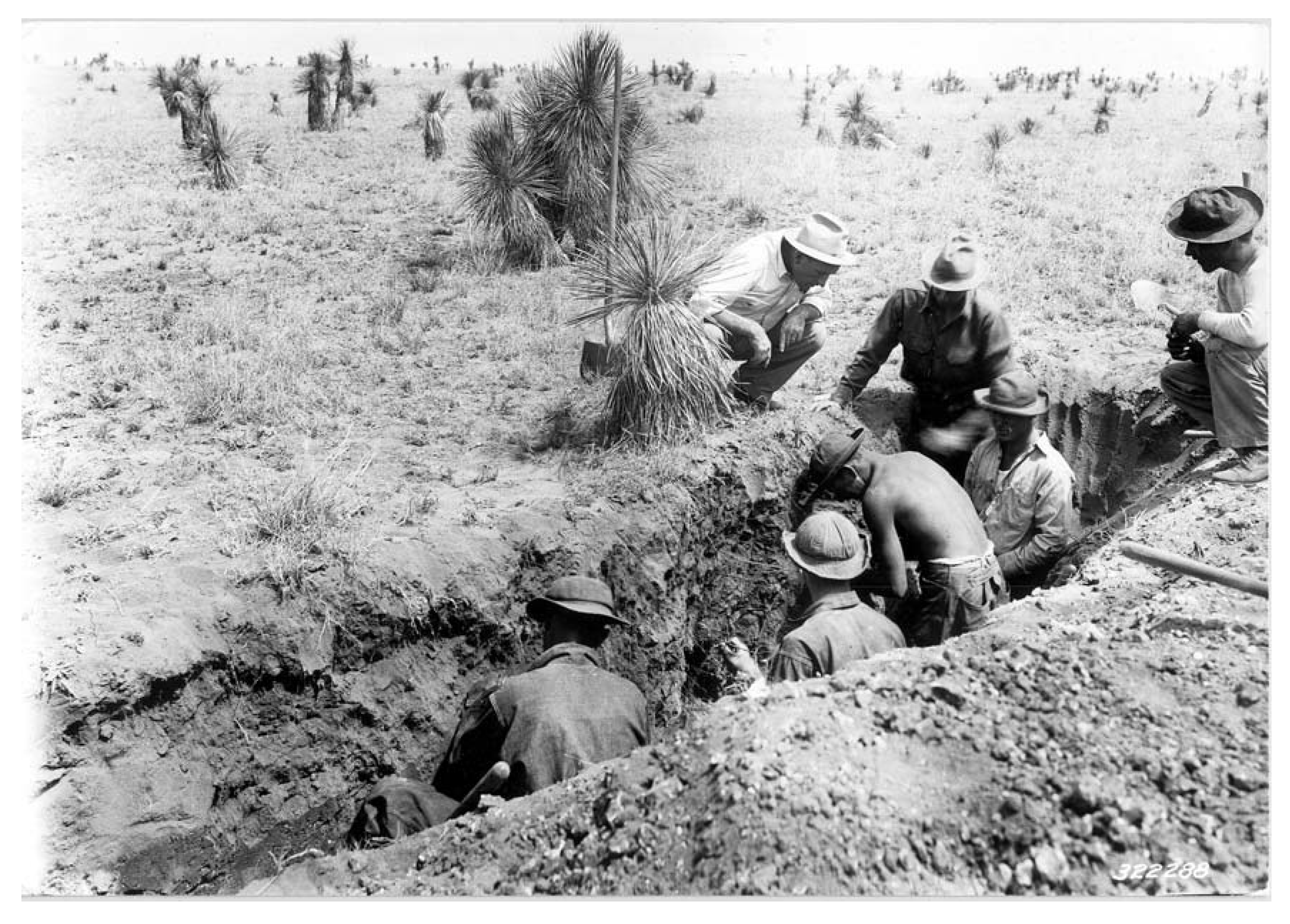
The Civilian Conservation Corps (CCC) had a significant presence on the range from 1933 to 1942. Their work included building stock tanks (
Figure 6), housing, headquarter facilities, and most importantly, establishing infrastructure for implementing various studies (
Figure 7) and experimental treatments under Jornada scientist supervision with the objective of improving rangeland conditions. Several CCC camps were located on the Jornada and the adjacent New Mexico State University’s Chihuahuan Desert Rangeland Research Center (CDRRC), providing a ready and close supply of the manpower required for numerous treatments. The effectiveness of these treatments were evaluated much later using aerial photography [
5].
Figure 1.
Fencing crew on the Jornada Range Reserve in October 1912 on a lunch break while installing boundary fences as established by the US Congress and signed into law by President William Taft on 4 May 1912.
Figure 1.
Fencing crew on the Jornada Range Reserve in October 1912 on a lunch break while installing boundary fences as established by the US Congress and signed into law by President William Taft on 4 May 1912.
The objective of this paper is to show how the culture of Western American ranching at the Jornada has resulted in science addressing traditional questions associated with rangeland management and new approaches to “get the job done” through non-traditional methods and investigations. An example of this dual approach is that we have gone back in time to expand our heritage of data and gone forward to lead the search for new ways to sustain our limited natural resources over vast rangeland areas. For example, going back in time to the 1858 General Land Office (GLO) surveys of southern New Mexico revealed early vegetation conditions at the Jornada [
6]. Along the historic timeline, we have acquired a large data set of aerial photography spanning from 1936 to the present day. Earth resources satellites began supplying imagery data of interest in 1972 with Landsat, and this effort continued to improve with more satellites and increased resolution over the last four decades. Because of the number of secure research areas and measurements that Jornada has available, we have become part of important national networks. One of our more exciting remote sensing advances is the use of Jornada UAVs to acquire imagery at very high resolution over remote rangeland areas for assessing rangeland conditions [
7].
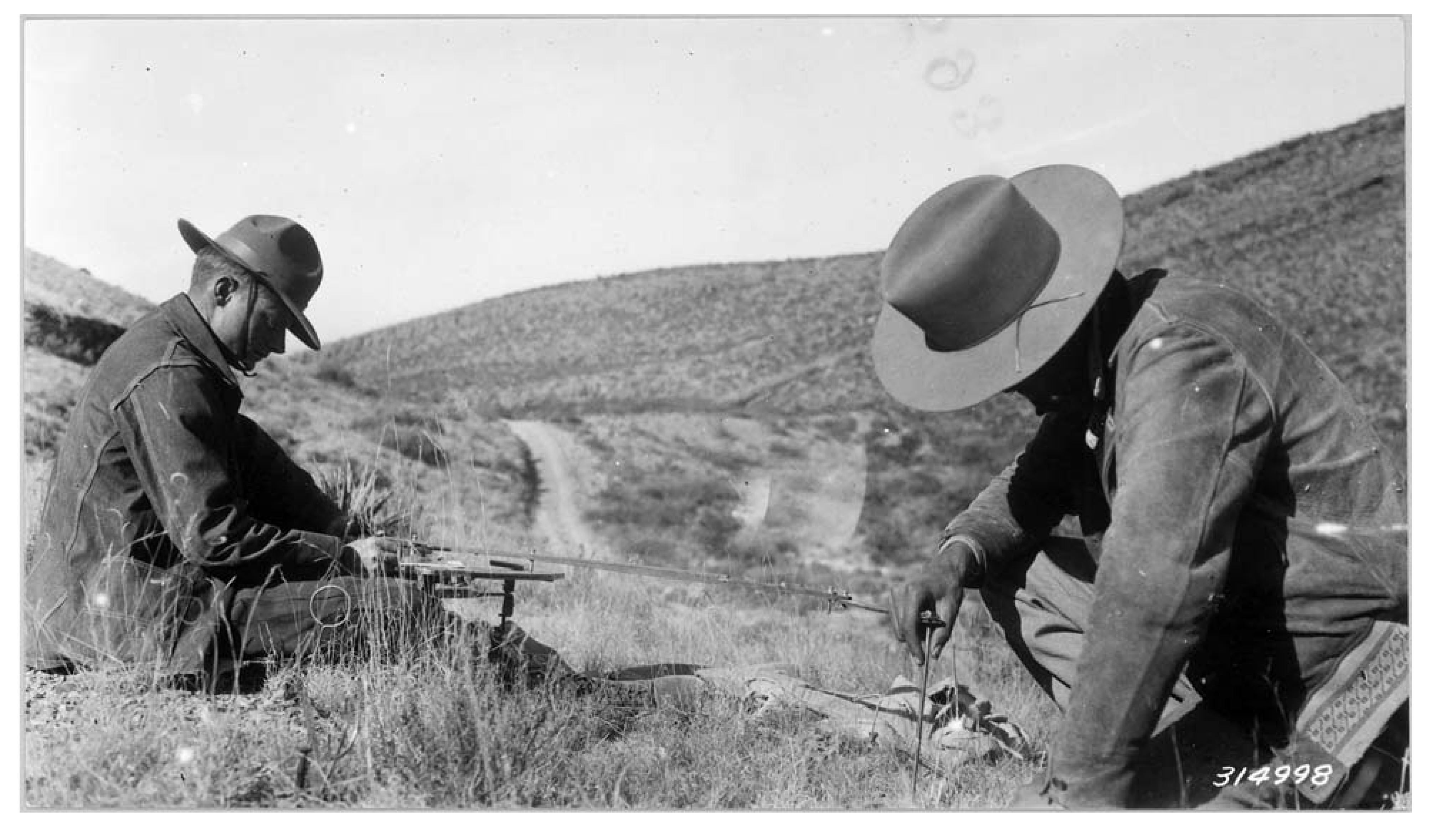
Figure 2.
Field work in the summer of 1930 with Mr. Canfield on the Jornada Experimental Range.
Figure 2.
Field work in the summer of 1930 with Mr. Canfield on the Jornada Experimental Range.
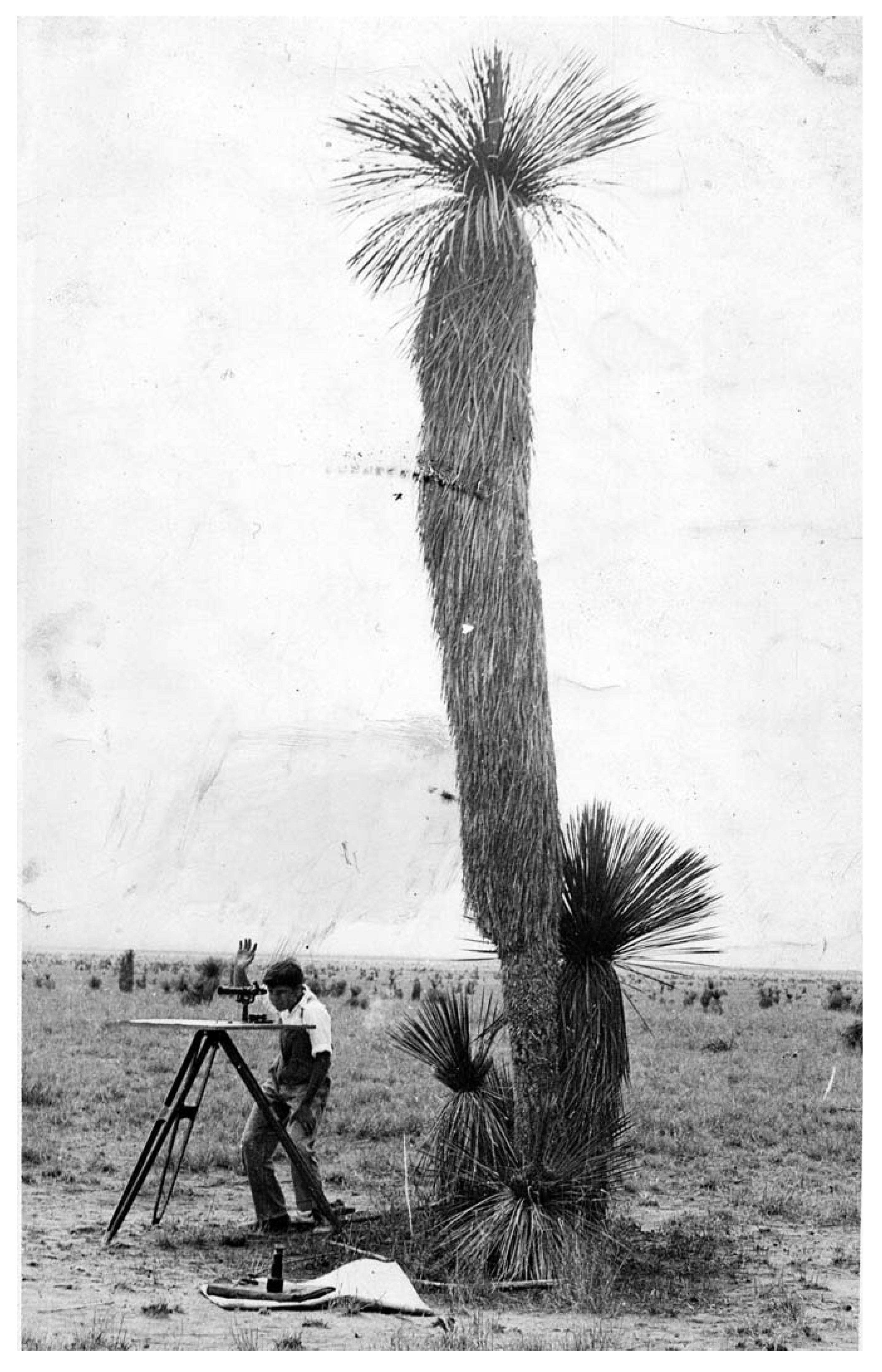
Figure 3.
J.T. Cassady and J.G. Keller charting vegetation Quadrat S-6 looking down Ropes Draw on 27 November 1933.
Figure 3.
J.T. Cassady and J.G. Keller charting vegetation Quadrat S-6 looking down Ropes Draw on 27 November 1933.
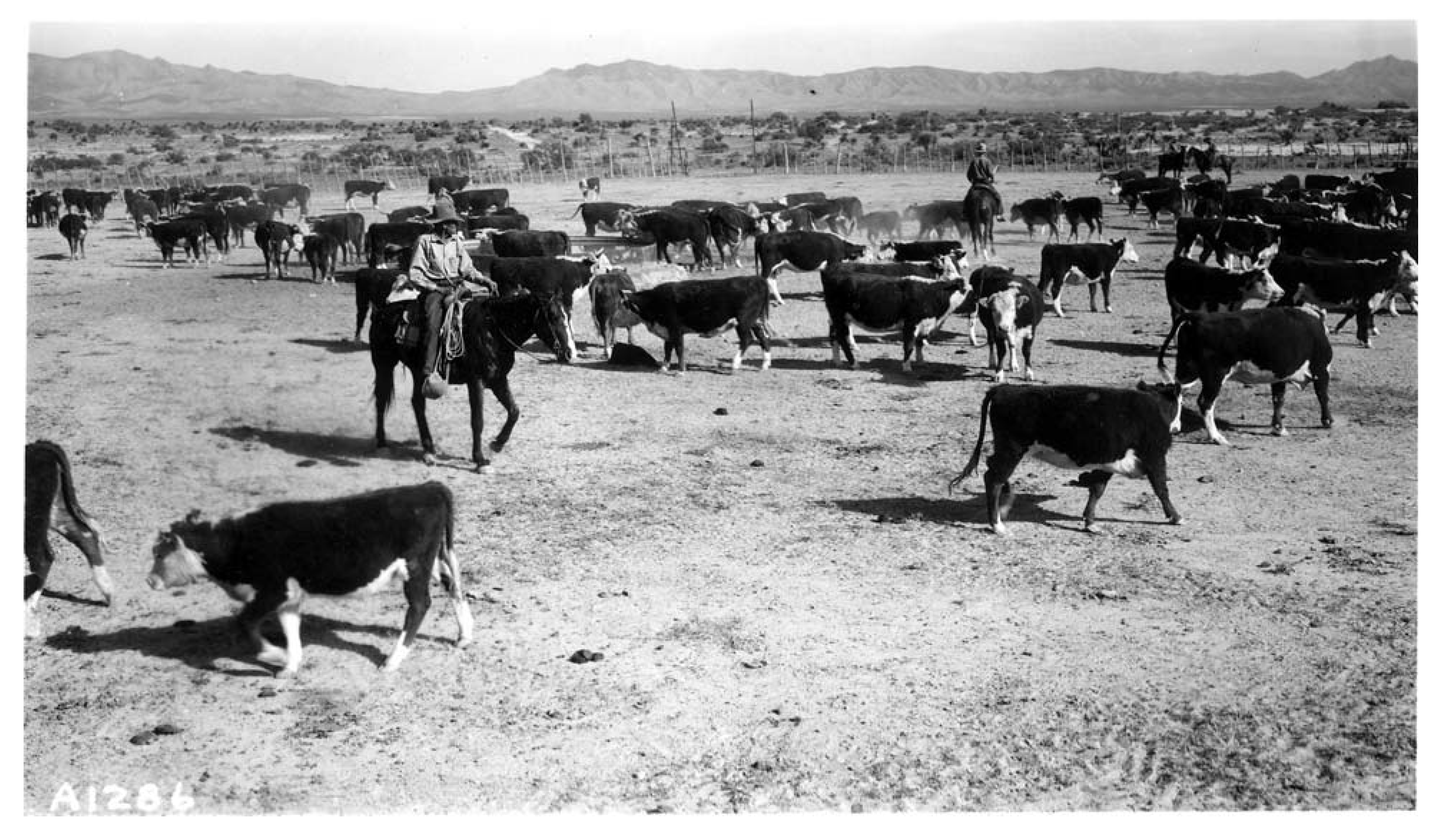
Figure 4.
Roundup of cattle herd from pasture 10 at the Jornada Experimental Range taken in October 1939.
Figure 4.
Roundup of cattle herd from pasture 10 at the Jornada Experimental Range taken in October 1939.
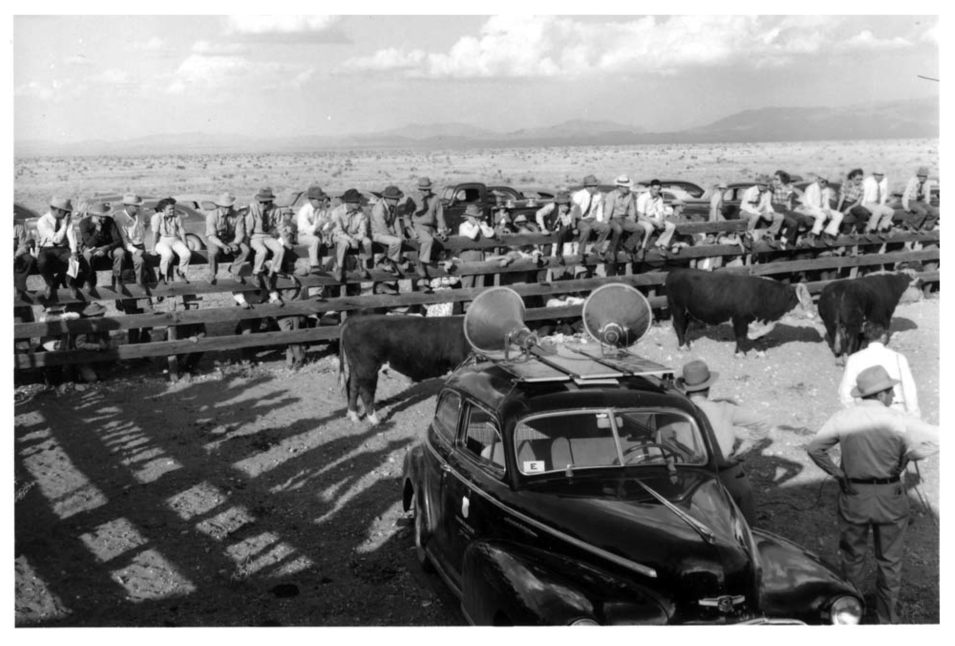
Figure 5.
Presentation of the latest grazing research results during Ranch Day on 14 October 1940 at the Jornada Experimental Range.
Figure 5.
Presentation of the latest grazing research results during Ranch Day on 14 October 1940 at the Jornada Experimental Range.
Figure 6.
Big Meadows stock tank being built by Civilian Conservation Corps at the Jornada Experimental Range on 3 April 1934 using three-horse Fresno teams.
Figure 6.
Big Meadows stock tank being built by Civilian Conservation Corps at the Jornada Experimental Range on 3 April 1934 using three-horse Fresno teams.
Figure 7.
Civilian Conservation Corps crew from Jornada Camp F-39-N digging trench for a root bisect and general soil-plant ecological study at Jornada on 21 April 1936.
Figure 7.
Civilian Conservation Corps crew from Jornada Camp F-39-N digging trench for a root bisect and general soil-plant ecological study at Jornada on 21 April 1936.
This paper will document this duality of efforts with previously acquired results as well as illustrate the groundbreaking approaches in rangeland UAV remote sensing and other geospatial applications. At the same time, we will illustrate why the Jornada is so valuable as a long term data resource open to cooperative remote sensing research with investigators around the globe [
8].
2. Acquisition of Historic Data
2.1. General Land Office Surveys
Soon after establishment of the Jornada, measurements were begun to assess the effects of managed livestock grazing. Formal USDA data sets date to 1912, but Jornada scientists felt that it would aid vegetation studies and change detection analysis if these data could be extended to earlier years when domestic grazing impacts on vegetation were limited (
i.e., prior to the US Civil War). The US federal government has over 6,500 volumes of GLO surveys (containing specific information allowing vegetation to be compiled dating back to 1855) that many fields of study (e.g., range management, ecology, forestry, geography, and archeology) employ to construct landscape descriptions either prior to settlement or before widespread, unregulated use and degradation [
9]. Many of the GLO surveys provide excellent vegetation data that can serve as a baseline. Such data were used by Jornada scientists to establish vegetation types present in 1858 [
6]. Coupling these early baseline data to repeat surveys in 1915, 1928, 1946, 1963, and 1998 [
10] increased the timeframe and our insight into the vegetation dynamics at the Jornada over a 140-year period.
Figure 8 shows the change in vegetation at Jornada beginning with the 1858 GLO survey through four subsequent vegetation surveys ending in 1998. Vegetation changes from one survey date to another (e.g., for grassland) can be attributed to multiple factors such as use of finer resolution aerial photos, recovery from significant climate events like the “1950s drought”, reduced stocking rates, and brush control treatments (e.g., herbicides to control mesquite).
Figure 8.
Broad-scale shift in dominant vegetation over 150 years at the Jornada Experimental Range.
Figure 8.
Broad-scale shift in dominant vegetation over 150 years at the Jornada Experimental Range.
2.2. Precipitation Measurements
The first precipitation measurements were collected at the Jornada in 1915 with US. Weather Bureau standard manual precipitation gauges. The standard rain gauge network has grown to 34 as listed in
Table 1. Manual gauges have been replaced by automated tipping bucket gauges which transmit data in real time to a server at the Jornada headquarters.
Table 1.
Standard Rain Gauges at the Jornada Experimental Range with Starting and Ending Dates.
Table 1.
Standard Rain Gauges at the Jornada Experimental Range with Starting and Ending Dates.
| Gauge name | Established | Terminated | Pasture | Latitude | Longitude | Altitude (m) |
|---|
| (WGS 84) |
|---|
| HEADQUARTERS | 1915 | On Going | HQ COMPLEX | 32.6169763347N | 106.741054547W | 1,318 |
| WEST WELL | 1918 | On Going | 2S | 32.605106317N | 106.845326643W | 1,321 |
| REDLAKE | 1918 | On Going | 3 | 32.7089794901N | 106.821259491W | 1,316 |
| ROPES SPRINGS | 1918 | On Going | MTN | 32.6773500745N | 106.560303012W | 1,725 |
| SOUTH WELL | 1919 | On Going | 11A | 32.5377624217N | 106.746279883W | 1,314 |
| RAGGED | 1922 | On Going | 20B | 32.5671224464N | 106.617387108W | 1,440 |
| DONA ANA | 1926 | On Going | 6 | 32.4872686943N | 106.750926424W | 1,326 |
| MIDDLE WELL | 1926 | On Going | 1B | 32.6915246024N | 106.786851543W | 1,314 |
| ROAD TANK | 1926 | On Going | 19 | 32.6719038925N | 106.657925317W | 1,412 |
| STUART WELL | 1926 | On Going | 6 | 32.4836810991N | 106.733349124W | 1,309 |
| YUCCA | 1926 | On Going | 5A | 32.5735661877N | 106.759559294W | 1,320 |
| ARISTIDA | 1927 | On Going | 2N | 32.6649020322N | 106.840862794W | 1,331 |
| BROWN TANK | 1927 | On Going | 12B | 32.6136589391N | 106.67377373W | 1,357 |
| NEW WELL | 1927 | On Going | 19 | 32.7142718066N | 106.625724442W | 1,487 |
| RABBIT | 1927 | On Going | 8A | 32.6087137764N | 106.796984519W | 1,325 |
| SANDHILL | 1927 | On Going | 1B | 32.7050701566N | 106.713585967W | 1,377 |
| RESTORATION | 1934 | 1997 | 12B | 32.6712840805N | 106.717572229W | 1,348 |
| CO-OP | 1937 | On Going | 8C | 32.5690464334N | 106.811682602W | 1,330 |
| ASH CANYON | 1937 | On Going | MTN | 32.6180698221N | 106.542212128W | 1,740 |
| MESQUITE | 1937 | On Going | 4A | 32.6485584354N | 106.78365364W | 1,320 |
| TAYLOR WELL | 1937 | On Going | 7A | 32.5627592483N | 106.692389047W | 1,332 |
| ANTELOPE | 1938 | On Going | 1B | 32.7196154919N | 106.777083092W | 1,333 |
| PARKER TANK | 1942 | On Going | 20A | 32.640520294N | 106.621408932W | 1,443 |
| EXCL A | 1959 | On Going | 11A | 32.5687514293N | 106.744250036W | 1,320 |
| EXCL B | 1959 | On Going | 8C | 32.5708203282N | 106.801374582W | 1,324 |
| N.E.EXCL | 1959 | On Going | 12C | 32.6679747629N | 106.75257343W | 1,316 |
| S.E. EXCL. | 1959 | 1997 | 6 | 32.4758976394N | 106.723315508W | 1,309 |
| BER | 1961 | 1997 | 9 | 32.5928941988N | 106.839206305W | 1,320 |
| ST. NICHOLAS | 1963 | On Going | MTN | 32.5799552654N | 106.528008531W | 1,867 |
| PASTURE 2 | 1965 | On Going | 2S | 32.6175687032N | 106.869378769W | 1,328 |
| GOAT MTN. | 1967 | On Going | MTN | 32.5577387099N | 106.489789462W | 1,984 |
| LEAD CAMP | 1967 | 1982 | MTN | 32.7298953524N | 106.577557179W | 1,590 |
| SAN ANDRECITO | 1967 | 1976 | MTN | 32.7825585337N | 106.586879251W | 1,585 |
| IBP | 1970 | On Going | 9 | 32.5865549365N | 106.843591997W | 1,324 |
| TURNEY | 1997 | On Going | 12B | 32.6919205458N | 106.706952807W | 1,365 |
| PERM. EXC. 1 | 1997 | On Going | 2S | 32.6469251739N | 106.869530021W | 1,331 |
| PERM. EXC. 6 | 1997 | On Going | 2N | 32.6956966887N | 106.869989362W | 1,336 |
| CROSS TANK | 1997 | On Going | 20A | 32.6018447156N | 106.637082763W | 1,397 |
| WOOTON | 1997 | On Going | 12B | 32.6504758784N | 106.683534689W | 1,382 |
2.3. Permanent Chart Quadrat Data
More than 100 permanent vegetation quadrats (1 m
2) were established at the Jornada in 1915. The vegetation in these quadrats was charted annually from 1915 to 1947 and annually in a subset of these quadrats from 1947 to 1979 to determine the basal area of perennial grasses, canopy cover of shrubs, and the location of other species (annual grasses or forbs). Measurements were renewed in 1996 on all quadrats and have been collected every five years thereafter. All quadrats have been GPSed and exist in ARC/INFO format. Data from the quadrats are being used to relate spatial and temporal variation in vegetation to climate and landscape position [
11].
2.4. Stocking Rate Records
Stocking rate grazing records by pasture by Animal Unit Months were started in 1915 and continue to the present for all pastures at Jornada. These records include horses, cattle, sheep, and goats. These records are available for comparison with precipitation and vegetation data, and for integration into studies examining long term effects of grazing on various parameters.
2.5. Ground-Based Photography
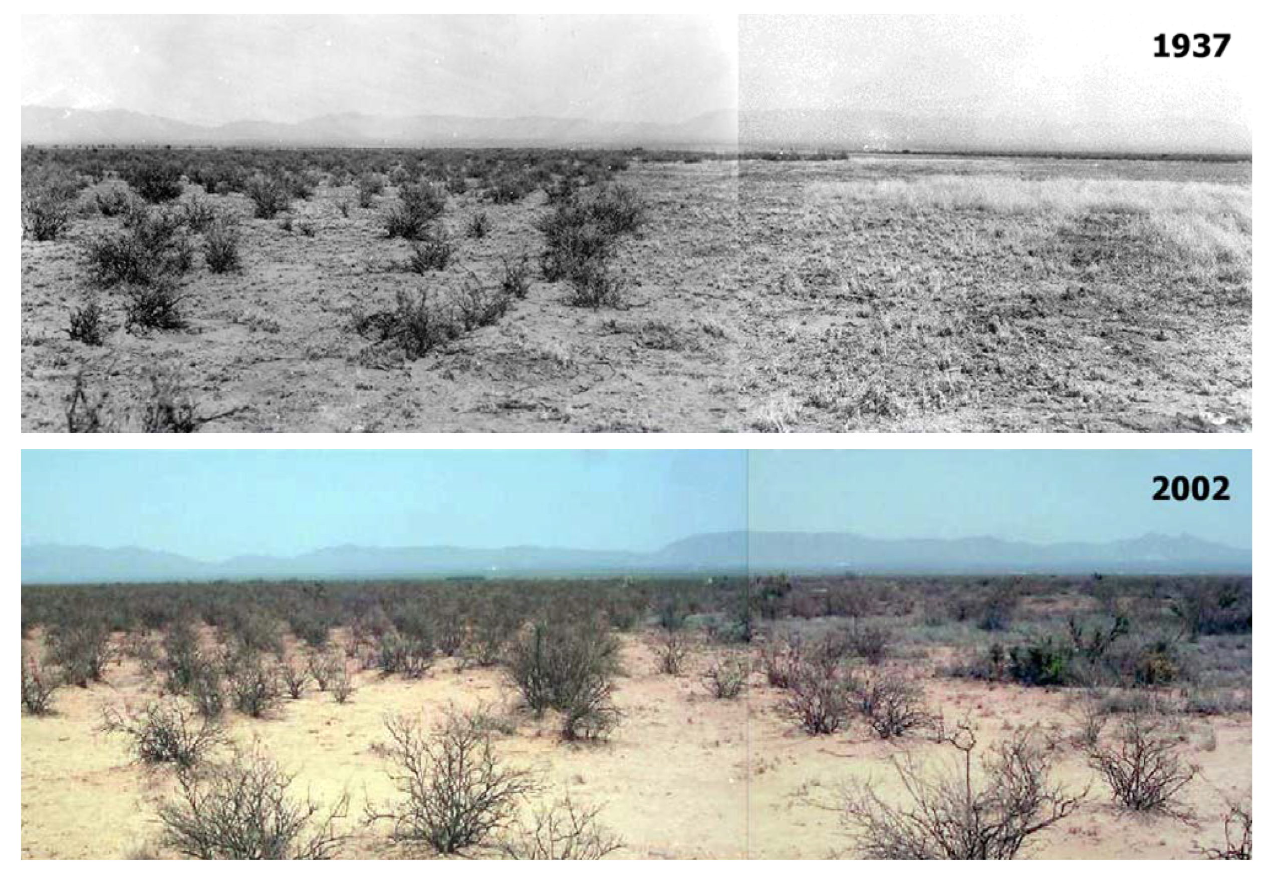
Ground photographs are used not only to document personnel and infrastructure, but can also be used to document vegetation and livestock types, rangeland treatments and their effects, and visual changes in various pastures. These photographs, when positionally documented, can be used for rephotography and change analysis. For example,
Figure 9 shows rephotography of a tarbush grubbing site at Jornada. Comparison of the site after treatment (tarbush removal) on 22 April 1937 to same site on 25 June 2002 documents reinvasion of tarbush [
12]. There are 3,148 ground-based images currently stored in the New Mexico State Library, Rio Grande Collection which can readily be browsed.
Figure 9.
Rephotography of a tarbush grubbing site at the Jornada Experimental Range. The top photo was taken on 22 April 1937, and the bottom photo was taken at the same location on 25 June 2002.
Figure 9.
Rephotography of a tarbush grubbing site at the Jornada Experimental Range. The top photo was taken on 22 April 1937, and the bottom photo was taken at the same location on 25 June 2002.
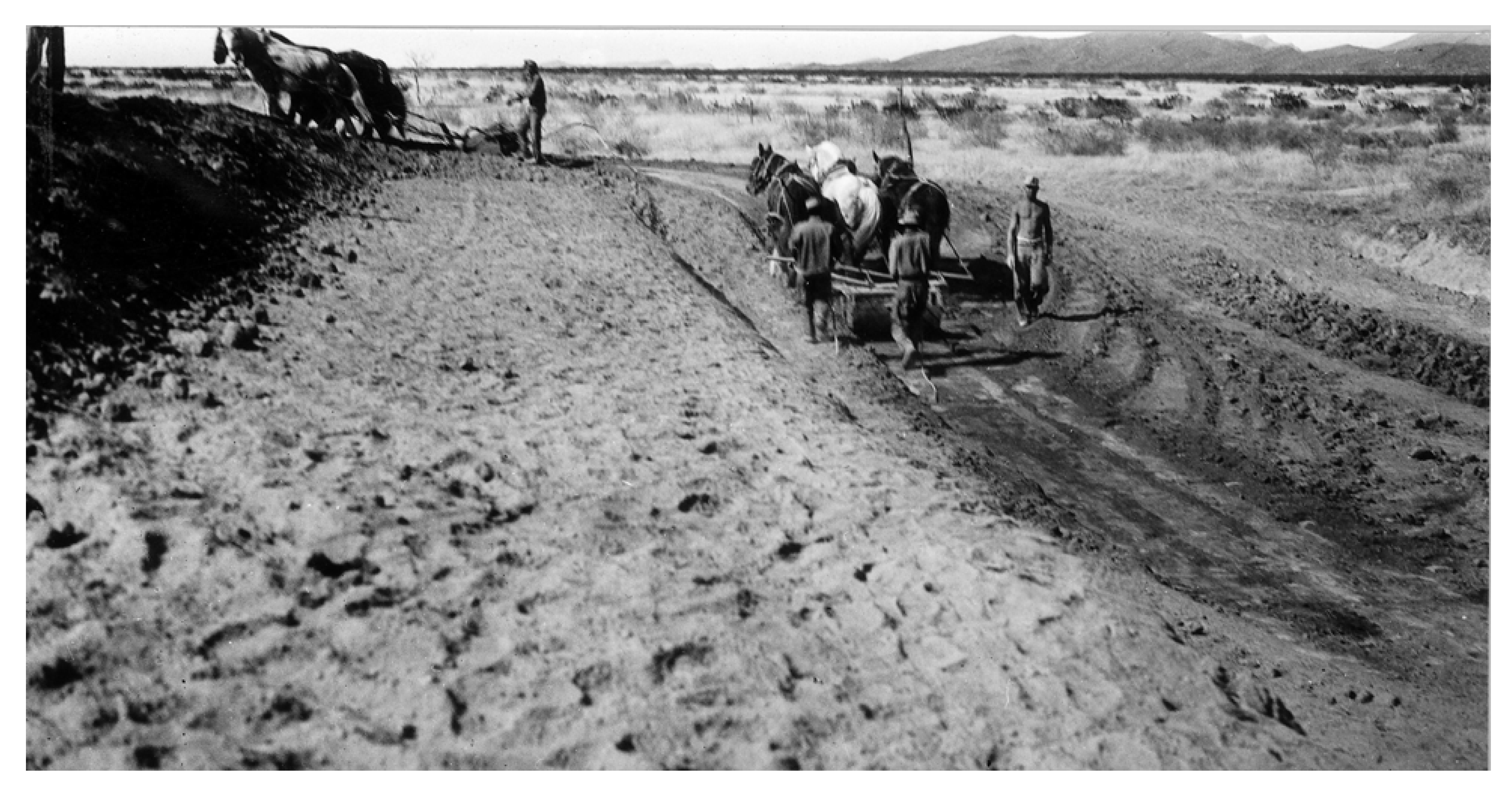
2.6. Soil Movement Measurements
In the 1930s both gridded 2–4 ha plots and a 600 m transect were established to monitor soil surface erosion over time across grassland and shrubland areas of Jornada. These soil surface movement study sites were established to record the physical movement of soil surface particles that is common to the Jornada and desert regions around the world in response to winds. The historical method employed in these early studies required a steel post or pipe to be driven into the ground and a notch permanently marked a set distance above the soil surface at time of establishment. Posts or pipes were placed along grid intersections at a density of 20–75 points/ha and along the transect at ~6/100 m. Direct measures of soil accumulation or loss based on the change in distance between the permanent notch and the resulting soil surface have been recorded periodically in subsequent years [
13]. An array of additional, more sophisticated instruments and experimental designs has further advanced wind erosion research at the Jornada [
14]. The importance of deserts as a source of dust and the role of perennial vegetation cover in reducing dust emissions is widely recognized as an important outcome of these historic studies [
15].
2.7. Establishment of Exclosures
Early in the research history of Jornada, scientists employed small, fenced areas to exclude livestock and protect either instrumented sites or specific, small areas of study from disturbances associated with livestock grazing. The very earliest exclosures were employed beginning in 1915 and were small (<0.405 ha), but provided protected areas for study of normal growth and development of key perennial grasses that provided forage for livestock in the region [
16]. Key principles for managing livestock grazing in these desert environments were derived in part from these exclosure-based studies [
17]. By the 1930s it was recognized that the spatial heterogeneity in this arid environment was substantial, and exclosures needed to be much larger in order to capture larger responses to both management practices and natural disturbances such as drought. During the 1930s four 259 ha exclosures were established in shrubland and grassland sites across the Jornada, and extensive initial measurements of vegetation conditions were collected immediately following their construction. Three of these exclosures remained intact throughout the ensuing decades and have been invaluable in capturing the natural dynamics and resilience of the Chihuahuan desert. These sites have been the basis for numerous studies on an array of subjects ranging from ant foraging habits to zonal transitions of a shrubland-grassland ecotone. The newer generation of exclosures established in recent decades has provided protection for estimates of net primary productivity, inherent species biodiversity, soil moisture dynamics, carbon fluxes, and surface reflectance features that can be remotely sensed. Though a relatively simple experimental methodology, this array of exclosures has had tremendous utility to this field science discipline.
2.8. Historical Aerial Photography
Long-term data sets are important in the fields of ecology, hydrology, rangeland science, and geography. Remote sensing is an especially important component of such studies when spatial and temporal changes are considerations. Although satellites can provide some spatial and temporal data, the spatial resolution of satellites is often insufficient, and, sometimes, the temporal frequency is inadequate. However, aerial photography, which dates back to the 1930s, has relatively high resolution of 1–2 m, but is an often overlooked data source. Even the original Jornada scientists may not have been aware that aerial photos were collected over the Jornada beginning in 1936, even though the aerial photo program was directed by two USDA agencies: the Soil Conservation Service (SCS) and the Agricultural Stabilization and Conservation Service (ASCS). These programs were established in an effort to improve farm income and verify farm program compliance following the Great Depression. For example, the SCS and ASCS arranged repetitive aerial photography to assess compliance by farmers to reduce acreage under cultivation in an effort to control supplies, stabilize crop prices, and increase soil-conserving crops. Both cultivated fields and rangelands were photographed. Although flights conducted by government agencies were not necessarily endorsed by Western American culture, efficient rangeland monitoring and management was of great interest. Because ground photography was an established method of documentation at the Jornada since its formation, the utilization of aerial photos was welcomed as an extension of this documentation.
Because aerial photography flights were flown repetitively, they became one of the best types of long-term spatial rangeland data. The major problem with these data is that they were not stored in a systematic manner in a central archive. Rather, data were maintained in a variety of locations around the country, sometimes in departmental archives of the USDA, US Department of Interior, and in later years, NASA. Some aerial photos were retained by the contractors who acquired the data, some were distributed to state agencies, some were retained by the military, some were transferred to the National Archives, and some eventually made their way to the local agency where the flights took place, (e.g., Jornada). When private aerial photo contractors were sold, the new owners often did not need the historic aerial photos and designated them for disposal. Some aerial photo data awaiting disposal were actually rescued at the last minute by university employees and were placed in small university archives [
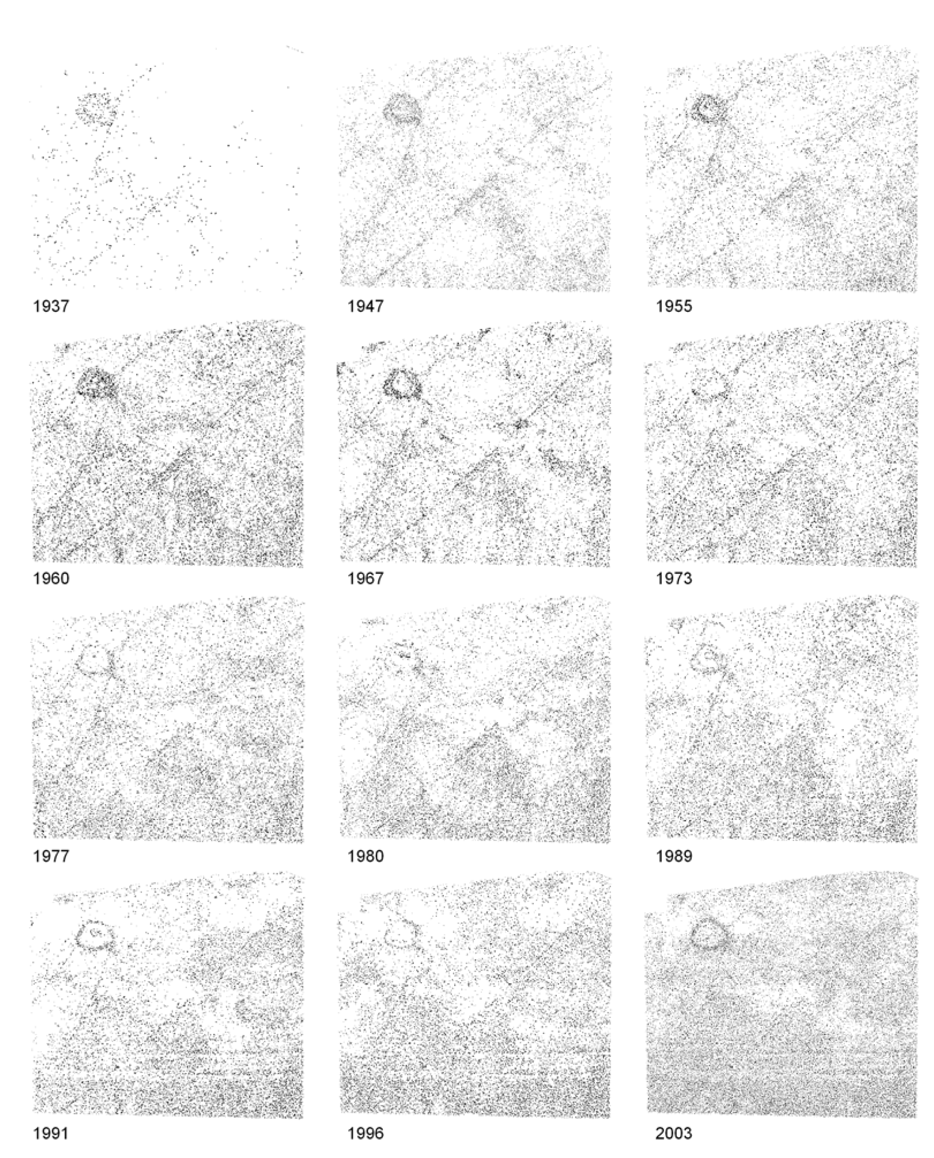
18]. Certainly, some aerial photos were destroyed or simply lost over time. The aerial photography acquired for the Jornada originated from many different archives and now totals approximately 5,700 images. They have been extremely valuable for long-term evaluations of change and for assessing effectiveness of various rangeland treatments. For example,
Figure 10 portrays the increase in shrubs using object-based classification from 1937 to 2003 in pasture 2 of the CDRRC (adjacent to the Jornada) using primarily the aerial photos in the Jornada database [
19]. Many locations at Jornada and CDRRC have aerial photo coverage consisting of at least one image per decade since the mid 1930s, with much greater frequently over certain sites.
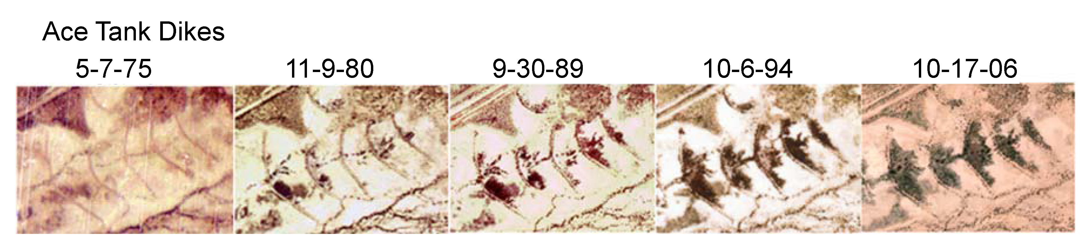
Aerial photography can be used to monitor the success of various land cover treatments. In 1975, shallow water ponding dikes were installed at Jornada.
Figure 11 shows a sequence of vegetation response to increases in soil moisture behind the dikes from 1975 to 2006. The dikes were not checked for many years, but then a scientist noticed the responses shown in
Figure 11. Because of the sporadic nature of rainfall in the Southwest US and other arid and semiarid regions, it may take 10–15 years before overland flow produces a significant vegetation response behind water ponding dikes.
Figure 10.
Shrub cover increase from 1937 to 2003 based on results from an object-based classification of the images on level 1 of the image object hierarchy using aerial photography and some high resolution satellite data.
Figure 10.
Shrub cover increase from 1937 to 2003 based on results from an object-based classification of the images on level 1 of the image object hierarchy using aerial photography and some high resolution satellite data.
Figure 11.
Five aerial photographs of Ace Tank from 1975 to 2006 showing progressive vegetation growth behind shallow water ponding dikes at the Jornada, an effective form of water harvesting in arid and semiarid regions.
Figure 11.
Five aerial photographs of Ace Tank from 1975 to 2006 showing progressive vegetation growth behind shallow water ponding dikes at the Jornada, an effective form of water harvesting in arid and semiarid regions.
2.9. Earth Resources Satellite Data
The first views of Jornada from space actually came from suborbital launches of the V-2 rocket immediately after the end of World War II by the Jornada’s contiguous neighbor to the east, the Department of Defense’s White Sands Missile Range. It was not until 1972 with the launch of Landsat that the resolution from satellites became less than 100 m. Seven consecutive Landsats have continued the program but the last two Landsats (5 and 7) have exceeded their operational lifetimes. There are several reasons to look forward to continued and expanded use of earth resources satellites. First, a follow-on Landsat is scheduled for launch in December 2012 [
20]. Second, a number of high resolution (<1 m) earth resources satellites like QuickBird and WorldView now provide more detailed imaging that is similar in spatial resolution to aerial photos. Third, widespread accessibility and use of Landsat data is increasing due to both regular launches and satellite longevity. A fourth reason is the recent decision by the U.S. Government to make Landsat data available free of charge. Because the desert Southwest has such a high percentage of clear skies, Landsat has high success rates for monitoring arid to semiarid rangelands.
2.10. Repetitive Remote Sensing Field Experiments
Since 1995, The JORNada EXperiment (JORNEX) has been conducted twice yearly at Jornada just before and after the summer monsoon rains. The particular dates each year are chosen to correspond with the Advanced Spaceborne Thermal Emission and Reflection Radiometer (ASTER), the Moderate Resolution Imaging Spectroradiometer (MODIS), and Landsat scheduled overpasses. Ground measurements (line-point intercept of vegetation height and type and radiometer surface temperatures) are collected in each of the major vegetation communities, and any other measurements needed by participating investigators are acquired on the overpass day. The 15-year JORNEX data set is available to scientists and their graduate students for analysis. For certain JORNEX dates, the same ground-based remote sensing instruments that were subsequently flown in space, including MODIS, ASTER, and the Multi-angle Imaging Spectroradiometer (MISR) were integrated with the field instruments being used for repetitive measurements.
3. A New Direction in Rangeland Remote Sensing
One challenge of melding remote sensing and rangeland science at the Jornada has been that although satellite data are generally valuable for studies over large areas, these data are not of sufficient spatial resolution to be useful for detection of important ecological indicators. This shortcoming is sometimes also true of conventional aerial photography with 1–2 m resolution. Specifically, rangeland experts consider spatial resolution of 10 cm or less to be appropriate for applications such as rangeland health determinations for which vegetation type and percent cover, gap sizes between vegetation, and amount of bare soil are important. This degree of resolution is generally only available from low flying piloted aircraft with advanced aerial mapping cameras or from low flying UAVs with low-cost digital cameras. The first approach was ruled out by Jornada scientists because of expense, but the UAV approach has proven more affordable. We purchased a fixed-wing UAV with a consumer grade digital camera in the wing to provide approximately 5 cm spatial resolution images and a video camera in the nose section for real-time video of the area below the UAV flight path. The UAV is a MLB Bat-3 which is catapult launched and flies either autonomously or manually using a gasoline engine. The MLB Bat-3 is classified as a light/mini UAV,
i.e., 5–50 kg in weight.
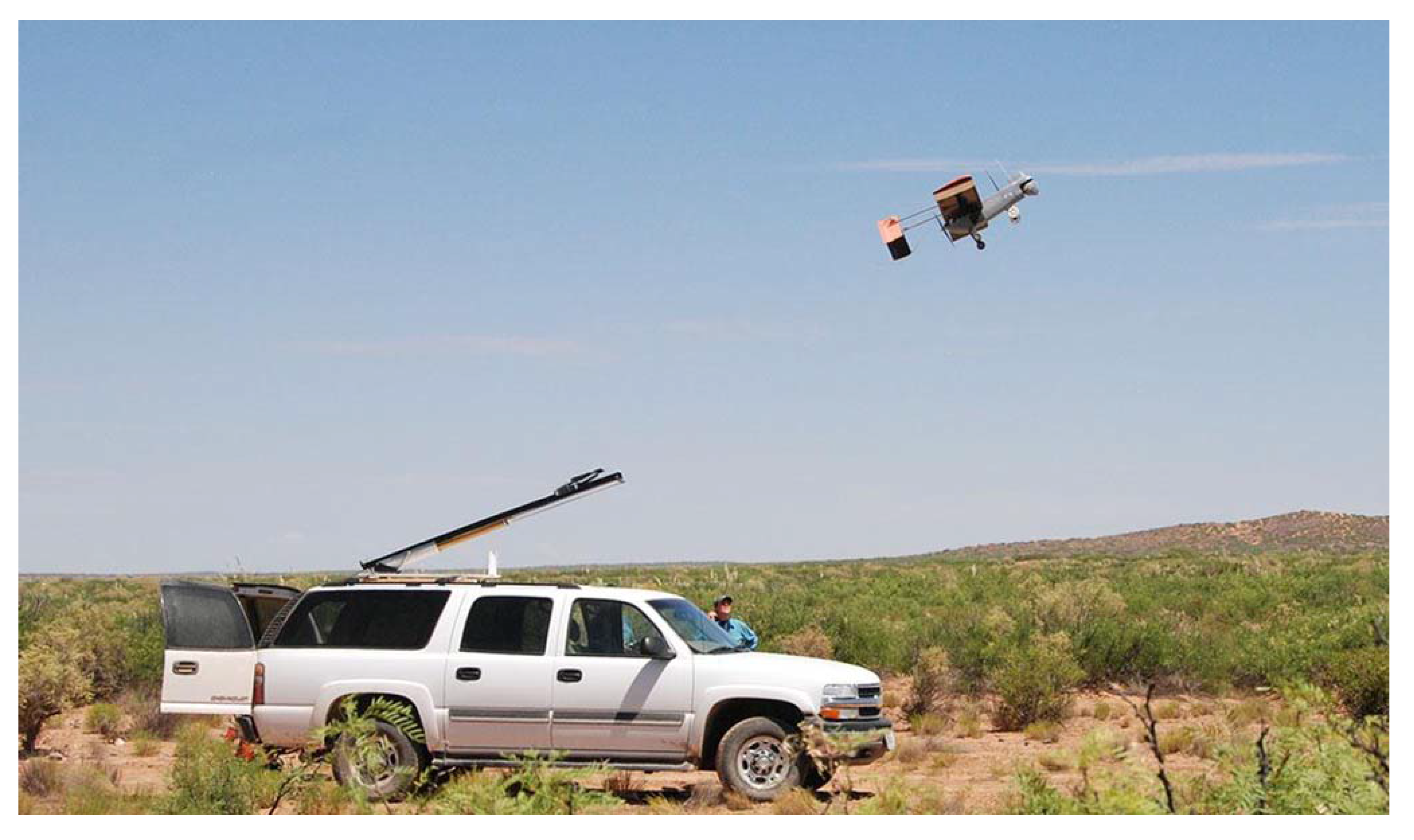
Figure 12 shows a launch of the Bat-3 at Jornada. Landing in rangeland areas usually occurs on a short unimproved runway (See
Figure 13).
Figure 12.
2010 launch of the Bat-3 UAV at Jornada.
Figure 12.
2010 launch of the Bat-3 UAV at Jornada.
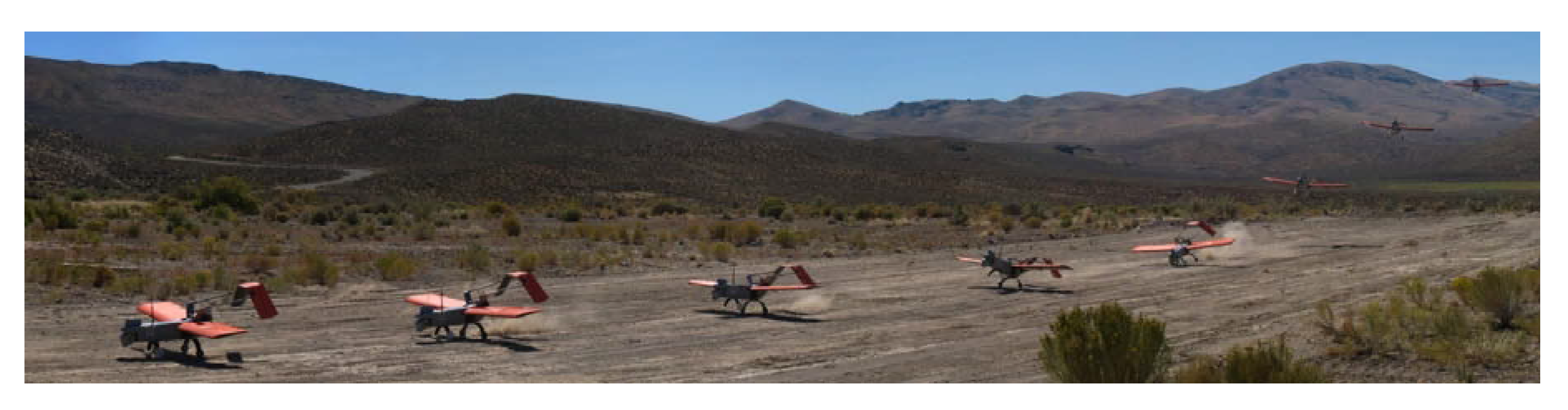
Figure 13.
Time sequence of the Jornada Bat-3 landing at the Reynolds Creek Experimental Watershed in Idaho during 2008.
Figure 13.
Time sequence of the Jornada Bat-3 landing at the Reynolds Creek Experimental Watershed in Idaho during 2008.
Our data are acquired with a Canon 10 MP camera. Flying at an altitude of about 214 m, we acquire images (160 × 213 m) with 70% forward overlap, 40% side overlap, and 5 cm spatial resolution. Because the images cover a relatively small area and the UAV can be affected by thermal turbulence, we have developed our own software to mosaic and georeference the data over large areas [
21]. This process provided us with the data necessary for quantifying rangeland status [
7]. This approach alleviated the need for expensive and labor intensive ground measurements. In comparing the UAV data to ground-based line-point intercept vegetation data, it was concluded that UAV data were comparable to the ground surveys (R
2 = 0.86 to 0.98) and that after measurement of eight plots, the UAV approach was more cost effective than extensive ground surveys [
21]. Other fields of study with similar promise in remote locations include hydrology and archeology.
3.1. Challenges Using the UAV Approach
If UAVs were permitted to fly in the FAA National Airspace System (NAS) according to their original design capabilities, they could efficiently acquire the required data by flying from a central launch, landing, and flight control location out to the study site, perhaps up to 15–25 km away. The UAV would then automatically enter the programmed flight pattern and acquire data, and then autonomously return to the central location to land. Upon landing, data are downloaded and additional flights can be flown, if necessary. Because complete FAA regulations for UAVs have not yet been established, all UAVs are required to fly under line-of-sight restrictions (
i.e., the radio control pilot must always maintain visual contact with the UAV in case the pilot needs to take manual control during an emergency). With most light/mini UAVs the line-of-sight distance is 0.8–1.1 km. This procedure increases the total time required for flights because arrival at the study site involves several steps in which the UAV and the pilot “leap frog” each other to maintain line-of-sight distance [
22].
This approach increases total flight hours by about four fold. However, this procedure allows for legal and safe UAV flights in the NAS and produces cost-efficient data not generally available by other means.
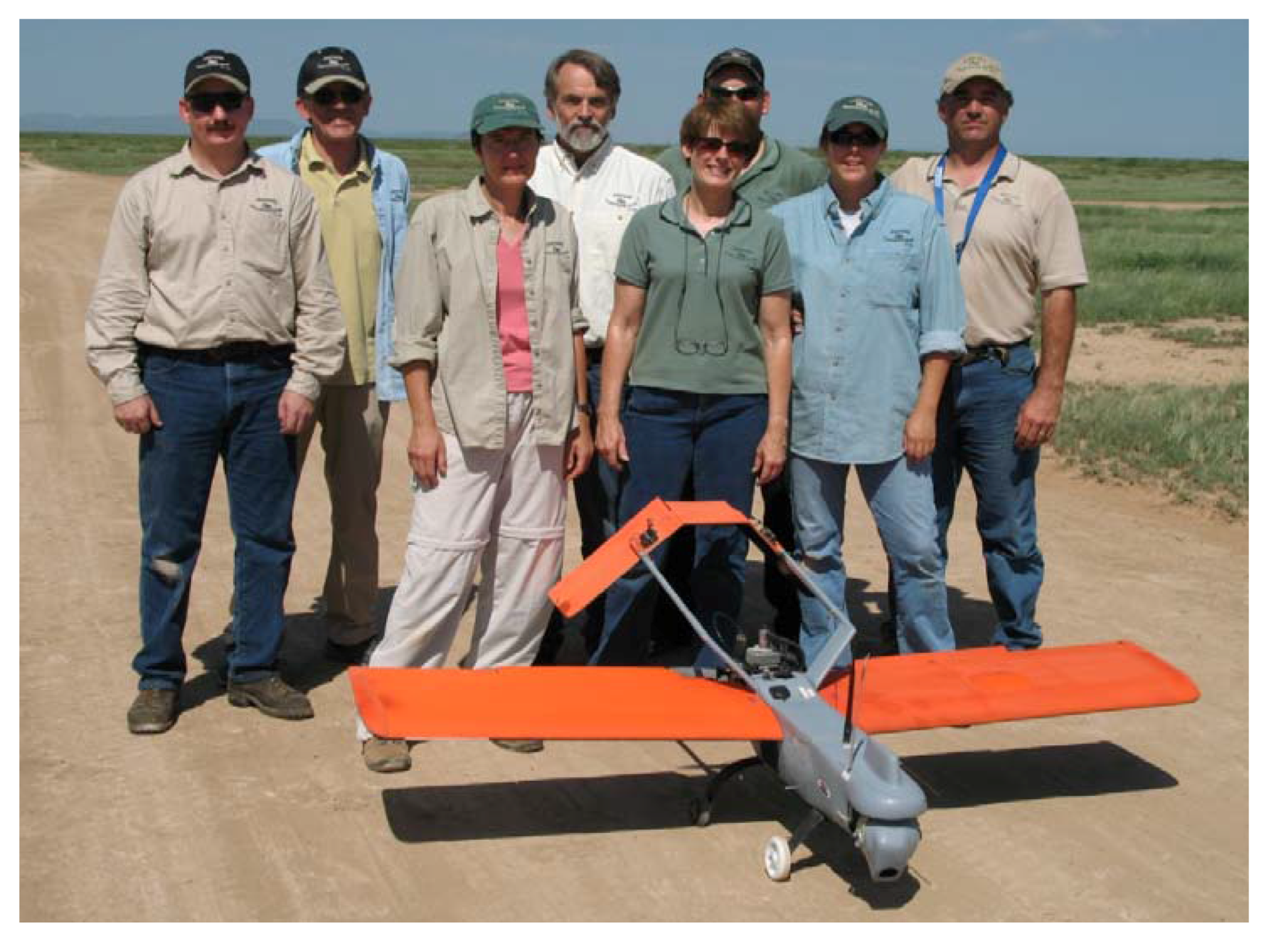
Another challenge is assembling a UAV flight crew that is qualified and self-sufficient. The UAV flight crew members must take and pass FAA Ground School and obtain second-class medical certificates, whether they are internal or external UAV pilots or observers on the mission. This training is time consuming, but it is essential in order to fly legally. Two of the Jornada flight team members have obtained a private pilot’s license in order to make the flight team self sufficient. These individuals are now qualified to serve in any role for the UAV team, including internal or external pilot or as the Pilot-In-Command. The Jornada UAV flight team is shown in
Figure 14. The minimum crew size needed to fly a mission is three to four people. It is important to train members for more than one flight function because not everyone is always available, especially on flight missions away from Jornada.
Figure 14.
The Jornada flight team responsible for UAV rangeland applications.
Figure 14.
The Jornada flight team responsible for UAV rangeland applications.
A final challenge is to georectify images and to construct mosaics. Because this is a new approach, it has been necessary to develop our own software to accomplish this critical task [
21].
3.2. Advantages to Owning Your UAV
The purchase price for the Jornada’s complete UAV system was less than $50,000. The advantage of controlling one’s own UAV for research is operating self-sufficiently independent of remote sensing platforms beyond our control based in distant locations. This versatility is consistent with the spirit of the Western America ranching culture, still existing today, in that it seeks to find out what is happening on the range right now. As long as we have approval from FAA or from agencies controlling restricted military airspace, we can launch missions whenever needed and when weather conditions are optimum.
High resolution data obtained from the UAV can be directly applied to rangeland health, rangeland characterization, or rangeland management. We have a low cost system and a UAV team that is committed to obtaining quality data. The UAV team has base funding assigned by USDA which keeps operating funds to a minimum. Our UAV manufacturer (MLB Co.) works closely with us to keep the UAV current and to troubleshoot problems. The company has recently integrated a new 6-band multispectral camera into the MLB Bat-3, which is currently undergoing flight testing. This new instrument should considerably increase our capability to distinguish vegetation species. We can potentially fly throughout the western US or anywhere in the world because of the excellent Jornada UAV flight team and their “can do” attitude.
We expect the UAV will ultimately replace other more costly and time consuming ground-based methods for monitoring rangelands just as the four-wheel drive vehicle replaced less reliable means of travel in the 1950s. Other methods will continue to be used, but the UAV will likely become a major contributor because it provides a new and efficient way to get needed and reliable data in real time. It can be used almost anywhere in the West except urban areas, it can save money and time, and it also has a certain appeal that can be appreciated by Western American culture.
For future developments, the larger Bat-4 UAV is being acquired because it has increased payload capacity compared to the Bat-3 (13.6 kg vs. 1.8 kg) This increase in payload will allow additional instruments to be used in rangeland applications. Possible future instrumentation for the Bat-4 includes LIDAR, hyperspectral scanners, and thermal infrared radiometers.
5. Discussion and Conclusions
Western American culture influenced the formation of the Jornada in 1912 and still is an important influence at Jornada and a few other research locations across the country. The heritage of the Jornada has always included the need to be aware of new science directions and technologies that would provide answers to rangeland problems and provide a better understanding of the key ecological processes at work. This effort began with the informal partnership of a rancher, C.T. Turney, and a scientist, E.O. Wooton, to cause the US Government to create the Jornada. The intent was to provide descriptive information about events leading to rangeland degradation and to conduct research on methods to restore these degraded rangelands. These efforts have continued for nearly a century through the harvesting and organization of all available information, including geospatial data that has helped the Jornada scientists quantify events from the past.
The assembly of historical data such as aerial photography was of great assistance for rangeland research, especially considering that we did not realize the extensive amount of Jornada data that was in scattered locations across the country (our initial holdings turned out to be the tip of an iceberg). For example, we have been able to use the aerial photographs to evaluate the effectiveness of past treatments from a temporal as well as a spatial perspective. We are gaining a much better understanding of the effectiveness of the different land cover treatments from these past data. The logical extension of this aerial photographic database has resulted in our UAV program. Jornada has taken on this UAV program because it allows us to monitor and manage rangelands more effectively in an independent fashion. The fact that we do not have to go through innumerable channels and wait for remote sensing platforms to become available increases our efficiency. We can view the data quickly and re-fly the target area immediately if the data do not meet quality standards, rather than waiting until the next time the platform becomes available. The accumulation of all past data in one location and the utilization of technological advances applicable to vast rangelands are important for maintaining our natural resources. At the same time, the use of these geospatial techniques allows us to retain our cultural heritage and advance it in a very positive manner. Because we are operating in vast open space as opposed to heavily populated areas, we can use techniques that are generally not applicable in more populated regions of the country.


