Estimation of Mass Balance of the Grosser Aletschgletscher, Swiss Alps, from ICESat Laser Altimetry Data and Digital Elevation Models

Abstract
:1. Introduction
2. Study Area and Data
2.1. Study Area
2.2. Data
2.2.1. ICESat/GLASS Data
2.2.2. SRTM DEM
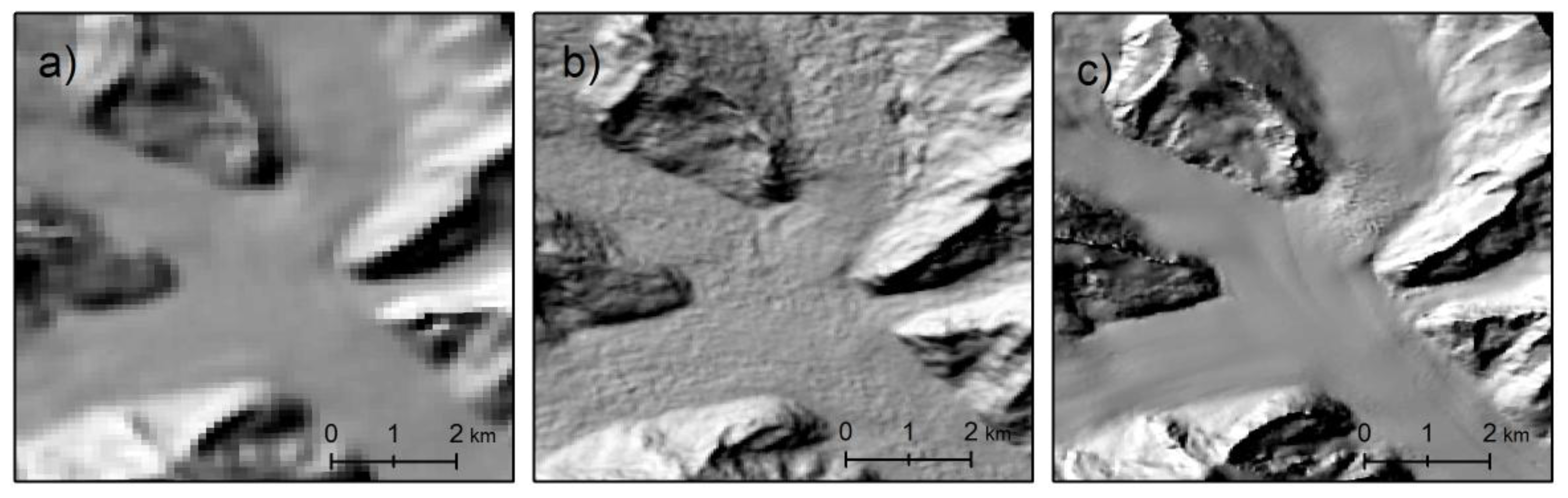
2.2.3. ASTER GDEM
2.2.4. Airphoto DEM
2.2.5. Glacier Outlines
3. Methods
4. Results
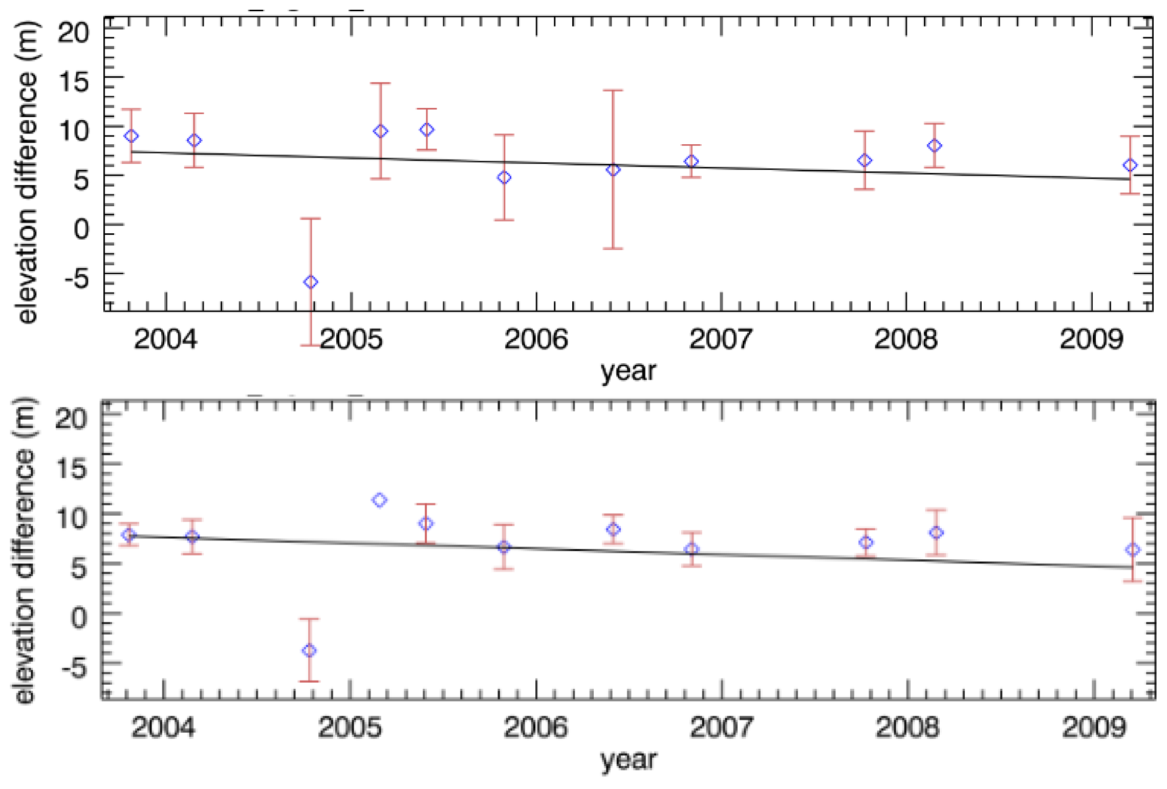
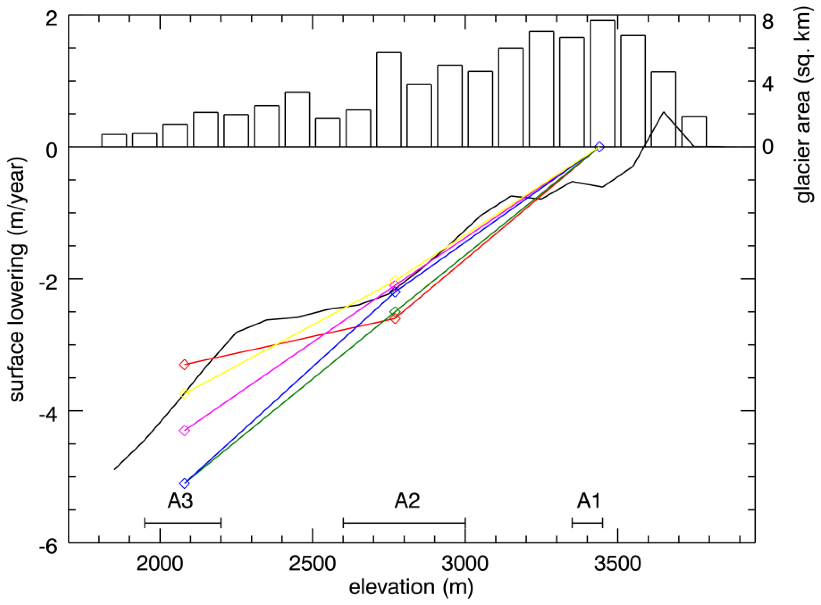
4.1. Trends in the Surface Lowering
4.2. Estimation of Mass Balance
4.3. Validation
5. Discussion
6. Conclusions
Acknowledgments
Conflicts of Interest
- Author ContributionsThe authors contributed to the reported research and writing of this paper as follows Jan Kropáček: 60%, 65%, Niklas Neckel: 25%, 25%, Andreas Bauder: 15%, 10%.
References and Notes
- WGMS, Global Glacier Changes: Facts and Figures; Zemp, M.; Roer, I.; Kääb, A.; Hoelzle, M.; Paul, F.; Haeberli, W. (Eds.) World Glacier Monitoring Service: Zurich, Switzerland, 2008.
- WGMS, Fluctuations of Glaciers 2005–2010; Volume X, Zemp, M.; Frey, H.; Gärtner-Roer, I.; Nussbaumer, S.U.; Hoelzle, M.; Paul, F.; Haeberli, W. (Eds.) World Glacier Monitoring Service: Zurich, Switzerland, 2012.
- Oerlemans, J. Glaciers and Climate Change; CRC Press: Rotterdam, The Netherlands, 2001. [Google Scholar]
- NSIDC. Available online: http://nsidc.org/data/icesat/orbit_grnd_trck.html (accessed on 24 October 2013).
- Howat, I.M.; Smith, B.E.; Joughin, I.; Scambos, T.A. Rates of southeast Greenland ice volume loss from combined ICESat and ASTER observations. Geophys. Res. Lett 2008. [Google Scholar] [CrossRef]
- Slobbe, D.; Lindenbergh, R.; Ditmar, P. Estimation of volume change rates of Greenland’s ice sheet from ICESat data using overlapping footprints. Remote Sens. Environ 2008, 112, 4204–4213. [Google Scholar]
- Moholdt, G.; Nuth, C.; Hagen, J.O.; Kohler, J. Recent elevation changes of Svalbard glaciers derived from ICESat laser altimetry. Remote Sens. Environ 2010, 114, 2756–2767. [Google Scholar]
- Rinne, E.J.; Shepherd, A.; Palmer, S.; van den Broeke, M.R.; Muir, A.; Ettema, J.; Wingham, D. On the recent elevation changes at the Flade Isblink Ice Cap, northern Greenland. J. Geophys. Res.: Earth Surface 2011. [Google Scholar] [CrossRef]
- Sørensen, L.S.; Simonsen, S.B.; Nielsen, K.; Lucas-Picher, P.; Spada, G.; Adalgeirsdottir, G.; Forsberg, R.; Hvidberg, C.S. Mass balance of the Greenland ice sheet (2003–2008) from ICESat data—The impact of interpolation, sampling and firn density. Cryosphere 2011, 5, 173–186. [Google Scholar]
- Brenner, A.C.; DiMarzio, J.P.; Zwally, H.J. Precision and accuracy of satellite radar and LASER altimeter data over the continental ice SHEETS. IEEE Trans. Geosci. Remote Sens 2007, 45, 321–331. [Google Scholar]
- Kääb, A.; Berthier, E.; Nuth, C.; Gardelle, J.; Arnaud, Y. Contrasting patterns of early twenty-first-century glacier mass change in the Himalayas. Nature 2012, 488, 495–498. [Google Scholar]
- Gardner, A.S.; Moholdt, G.; Cogley, J.G.; Wouters, B.; Arendt, A.A.; Wahr, J.; Berthier, E.; Hock, R.; Pfeffer, W.T.; Kaser, G.; et al. A reconciled estimate of glacier contributions to sea level rise: 2003 to 2009. Science 2013, 340, 852–857. [Google Scholar]
- Neckel, N.; Kropáček, J.; Bolch, T.; Hochschild, V. Glacier mass changes on the Tibetan Plateau 2003–2009 derived from ICESat laser altimetry measurements. Environ. Res. Lett 2014. [Google Scholar] [CrossRef]
- Bauder, A.; Funk, M.; Huss, M. Ice-volume changes of selected glaciers in the Swiss Alps since the end of the 19th century. Ann. Glaciol 2007, 46, 145–149. [Google Scholar]
- Holzhauser, H. Die bewegte Vergangenheit des Grossen Aletschgletschers. Blätter aus der Walliser Geschichte 2009, 41, 103–121. [Google Scholar]
- Thyssen, F.; Ahmad, M. Ergebnisse seismischer Messungen auf dem Aletschgletscher. Polarforschung, Bremerhaven, Alfred Wegener Institute for Polar and Marine Research & German Society of Polar Research 1969, 39, 283–293. [Google Scholar]
- Huss, M.; Hock, R.; Bauder, A.; Funk, M. 100-year mass changes in the Swiss Alps linked to the Atlantic Multidecadal Oscillation. Geophys. Res. Lett 2010. [Google Scholar] [CrossRef]
- Huss, M.; Bauder, A.; Funk, M.; Hock, R. Determination of the seasonal mass balance of four Alpine glaciers since 1865. J. Geophys. Res.: Earth Surface 2008. [Google Scholar] [CrossRef]
- Schutz, B.E.; Zwally, H.J.; Shuman, C.A.; Hancock, D.; Di Marzio, J.P. Overview of the ICESat mission. Geophys. Res. Lett 2005. [Google Scholar] [CrossRef]
- Abdalati, W.; Zwally, H.J.; Bindschadler, R.; Csatho, B.; Farrell, S.L.; Fricker, H.A.; Harding, D.; Kwok, R.; Lefsky, M.; Markus, T.; et al. The ICESat-2 laser altimetry mission. Proc. IEEE 2010, 98, 735–751. [Google Scholar]
- Zwally, H.J.; Schutz, R.; Bentley, C.; Bufton, J.; Herring, T.; Minster, J.; Spinhirne, J.; Thomas, R. GLAS/ICESat L2 Global Land Surface Altimetry Data, Version 33; National Snow and Ice Data Center: Boulder, CO, USA, 2003. [Google Scholar]
- Rabus, B.; Eineder, M.; Roth, A.; Bamler, R. The shuttle radar topography mission, a new class of digital elevation models acquired by spaceborne radar. ISPRS J. Photogramm. Remote Sens 2003, 57, 241–262. [Google Scholar]
- Farr, T.G.; Rosen, P.A.; Caro, E.; Crippen, R.; Duren, R.; Hensley, S.; Kobrick, M.; Paller, M.; Rodriguez, E.; Roth, L.; et al. The shuttle radar topography mission. Rev. Geophys 2007. [Google Scholar] [CrossRef]
- Sun, G.; Ranson, K.J.; Kharuk, V.I.; Kovacs, K. Validation of surface height from shuttle radar topography mission using shuttle laser altimeter. Remote Sens. Environ 2003, 88, 401–411. [Google Scholar]
- Hoffman, D.; Walter, J. How complementary are SRTM-X and -C band digital elevation models? Photogramm. Eng. Remote Sens 2006, 72, 261–268. [Google Scholar]
- Gorokhovich, Y.; Voustianiouk, A. Accuracy assessment of the processed SRTM-based elevation data by CGIAR using field data from USA and Thailand and its relation to the terrain characteristics. Remote Sens. Environ 2006, 104, 409–415. [Google Scholar]
- Carabajal, C.C.; Harding, D.J. ICESat validation of SRTM C-band digital elevation models. Geophys. Res. Lett 2005. [Google Scholar] [CrossRef]
- Tachikawa, T.; Kaku, M.; Iwasaki, A.; Gesch, D.; Oimoen, M.; Zhang, Z.; Danielson, J.; Krieger, T.; Curtis, B.; Haase, J.; et al. ASTER Global Digital Elevation Model Version 2—Summary of Validation Results. Available online: http://www.ersdac.or.jp/GDEM/ver2Validation/ (accessed on 1 November 2013).
- Frey, H.; Paul, F. On the suitability of the SRTM DEM and ASTER GDEM for the compilation of topographic parameters in glacier inventories. Int. J. Appl. Earth Observ. Geoinf 2011. [Google Scholar] [CrossRef]
- Armstrong, R.; Raup, B.; Khalsa, S.; Barry, B.; Kargel, J.; Helm, C.; Kieffer, H. GLIMS Glacier Database; National Snow and Ice Data Center: Boulder, CO, USA, 2005. [Google Scholar]
- Nuth, C.; Kääb, A. Co-registration and bias corrections of satellite elevation data sets for quantifying glacier thickness change. Cryosphere 2011, 5, 271–290. [Google Scholar]
- Bhang, K.J.; Schwartz, F.W.; Braun, A. Verification of the vertical error in C-band SRTM DEM using ICESat and Landsat-7, Otter Tail County, MN. IEEE Trans. Geosci. Remote Sens 2007, 45, 36–44. [Google Scholar]
- Wesche, C.; Riedel, S.; Steinhage, D. Precise surface topography of the grounded ice ridges at the Ekströmisen, Antarctica, based on several geophysical data sets. ISPRS J. Photogramm. Remote Sens 2009, 64, 381–386. [Google Scholar]
- Hilbert, C.; Schmullius, C. Influence of surface topography on ICESat/GLAS forest height estimation and waveform shape. Remote Sens 2012, 4, 2210–2235. [Google Scholar]
- Schubert, A.; Faes, A.; Kääb, A.; Meier, E. Glacier surface velocity estimation using repeat TerraSAR-X images: Wavelet- vs. correlation-based image matching. ISPRS J. Photogramm. Remote Sens 2013, 82, 49–62. [Google Scholar]
- Huss, M. Density assumptions for converting geodetic glacier volume change to mass change. Cryosphere 2013, 7, 877–887. [Google Scholar]
- Koblet, T.; Gärtner-Roer, I.; Zemp, M.; Jansson, P.; Thee, P.; Haeberli, W.; Holmlund, P. Reanalysis of multi-temporal aerial images of Storglaciären, Sweden (1959–99)—Part 1: Determination of length, area, and volume changes. Cryosphere 2010, 4, 333–343. [Google Scholar]
- Fischer, A. Comparison of direct and geodetic mass balances on a multi-annual scale. Cryosphere 2011, 5, 107–124. [Google Scholar]
- Berthier, E.; Schiefer, E.; Clarke, G.K.C.; Menounos, B.; Rémy, F. Contribution of Alaskan glaciers to sea-level rise derived from satellite imagery. Nature Geosc 2010. [Google Scholar] [CrossRef] [Green Version]
- Rignot, E.; Echelmeyer, K.A.; Krabill, W. Penetration depth of interferometric synthetic-aperture radar signals in snow and ice. Geophys. Res. Lett 2001, 28, 501–504. [Google Scholar]
- Gardelle, J.; Berthier, E.; Arnaud, Y. Impact of resolution and radar penetration on glacier elevation changes computed from DEM differencing. J. Glaciol 2012, 58, 419–422. [Google Scholar]
- Machguth, H.; Paul, F.; Hoelzle, M. Strong spatial variability of snow accumulation observed with helicopter-borne GPR on two adjacent Alpine glaciers. Geophys. Res. Lett 2006. [Google Scholar] [CrossRef]
- Farinotti, D.; Usselmann, S.; Huss, M.; Bauder, A.; Funk, M. Runoff evolution in the Swiss Alps: Projections for selected high-alpine catchments based on ENSEMBLES scenarios. Hydrol. Process 2012, 26, 1909–1924. [Google Scholar]


| DEM | Horizontal Shift (m) | Azimuth of the Shift (deg.) |
|---|---|---|
| SRTM-C | 70.8 | 124.2 |
| SRTM-X | 40.0 | 72.1 |
| Airphoto DEM | 55.1 | −106.3 |
| ASTER GDEM | 17.1 | 200.6 |
| Elevation Reference | Area | Mean ΔH (m) | σ of ΔH (m) | Mean Surface Lowering (m/a) | f-Value | Canceled Points (%) | Canceled Tracks (No) |
|---|---|---|---|---|---|---|---|
| SRTM-C | A1 | 8.1 | 4.7 | −0.2 ± 0.32 | 0.41 | 55.8 | 1 |
| ASTER GDEM original | A1 | −13.4 | 12.9 | 0.2 ± 1.05 | 0.02 | 76.1 | 2 |
| ASTER GDEM smoothed | A1 | −12.7 | 10.2 | 0.1 ± 0.67 | 0.04 | 58.9 | 1 |
| Airphoto DEM | A1 | 5.5 | 3.9 | −0.0 ± 0.30 | 0.02 | 54.3 | 1 |
| SRTM-C | A2 | −6.1 | 2.8 | −2.5 ± 0.13 | 380.6 | 14.9 | 1 |
| ASTER GDEM original | A2 | −3.8 | 4.2 | −2.2 ± 0.20 | 125.9 | 33.2 | 1 |
| ASTER GDEM smoothed | A2 | −3.3 | 3.5 | −2.1 ± 0.15 | 183.8 | 15.9 | 1 |
| Airphoto DEM | A2 | 10.7 | 1.9 | −2.6 ± 0.10 | 759.8 | 16.8 | 1 |
| DGPS | A2 | 15.0 | 0.9 | −2.6 ± 0.08 | 788.5 | 7.5 | 1 |
| SRTM-C | A3 | −25.6 | 4.4 | −5.1 ± 0.35 | 209.06 | 28.2 | 2 |
| ASTER GDEM original | A3 | −18.2 | 4.6 | −4.3 ± 0.52 | 68.32 | 56.4 | 2 |
| ASTER GDEM smoothed | A3 | −17.1 | 4 | −5.1 ± 0.34 | 217.44 | 30.8 | 2 |
| Airphoto DEM | A3 | 17 | 3.8 | −3.3 ± 0.36 | 84.77 | 39.7 | 2 |
| SRTM-X | A3 | −22.6 | 4.4 | −5.3 ± 0.39 | 189.23 | 33.3 | 2 |
| Tested Change | Area | Surface Lowering | Sigma | f-Value | Mass Balance |
|---|---|---|---|---|---|
| threshold for terrain slope 10° | A1 | 50.0% | 0.0% | 120.5% | 1.74% |
| A2 | 3.2% | −30.8% | 119.7% | ||
| A3 | 0.0% | 9.1% | −15.1% | ||
| snow pack correction | A1 | −15.7% | 2.6% | −33.3% | 0.44% |
| A2 | −1.9% | 22.2% | −33.7% | ||
| A3 | 3.0% | 5.6% | −5.3% | ||
| selection of autumn measurements | A1 | −70.6% | 34.2% | −95.2% | −5.8% |
| A2 | 6.8% | 7.7% | 0.3% | ||
| A3 | −18.9% | 63.6% | −75.4% | ||
| smoothing of ΔH profiles | A1 | 58.8% | −15.8% | 237.3% | −4.8% |
| A2 | −0.4% | −23.1% | 71.0% | ||
| A3 | 0.9% | 60.6% | −59.1% |
| DEM | Mass Balance (m w.e. a−1) |
|---|---|
| Airphoto DEM | −0.92 ± 0.18 |
| SRTM-C | −1.04 ± 0.19 |
| GDEM ASTER original | −0.90 ± 0.17 |
| GDEM ASTER smoothed | −0.94 ± 0.18 |
| subtraction of DEMs | −1.02 ± 0.34 |
© 2014 by the authors; licensee MDPI, Basel, Switzerland This article is an open access article distributed under the terms and conditions of the Creative Commons Attribution license (http://creativecommons.org/licenses/by/3.0/).
Share and Cite
Kropáček, J.; Neckel, N.; Bauder, A. Estimation of Mass Balance of the Grosser Aletschgletscher, Swiss Alps, from ICESat Laser Altimetry Data and Digital Elevation Models. Remote Sens. 2014, 6, 5614-5632. https://doi.org/10.3390/rs6065614
Kropáček J, Neckel N, Bauder A. Estimation of Mass Balance of the Grosser Aletschgletscher, Swiss Alps, from ICESat Laser Altimetry Data and Digital Elevation Models. Remote Sensing. 2014; 6(6):5614-5632. https://doi.org/10.3390/rs6065614
Chicago/Turabian StyleKropáček, Jan, Niklas Neckel, and Andreas Bauder. 2014. "Estimation of Mass Balance of the Grosser Aletschgletscher, Swiss Alps, from ICESat Laser Altimetry Data and Digital Elevation Models" Remote Sensing 6, no. 6: 5614-5632. https://doi.org/10.3390/rs6065614