Article

Citizen Bio-Optical Observations from Coast- and Ocean and Their Compatibility with Ocean Colour Satellite Measurements

1
Institute for Chemistry and Biology of the Marine Environment, University of Oldenburg, Schleusenstraße 1, Wilhelmshaven 26382, Germany
2
Life Sciences and Chemistry, Jacobs University, Campus Ring 1, Bremen 28759, Germany
3
Institue of Marine Sciences, Spanish National Research Council (ICM-CSIC), Passeig Maritim de la Barceloneta, Barcelona 08003, Spain
4
1000001 Labs, Alzina 52, Barcelona 08024, Spain
5
MARIS, Kon. Julianalaan 345A, Voorburg 2273 JJ, The Netherlands
6
Royal Netherlands Institute for Sea Research (NIOZ), P.O. Box 59, Den Burg/Texel 1790 AB, The Netherlands
7
Institute for Environmental Studies (IVM), VU University Amsterdam, De Boelelaan 1087, Amsterdam 1081 HV, The Netherlands
*
Author to whom correspondence should be addressed.
Remote Sens. 2016, 8(11), 879; https://doi.org/10.3390/rs8110879
Submission received: 1 August 2016 / Revised: 30 September 2016 / Accepted: 15 October 2016 / Published: 25 October 2016
(This article belongs to the Special Issue Citizen Science and Earth Observation)

Abstract

:
Marine processes are observed with sensors from both the ground and space over large spatio-temporal scales. Citizen-based contributions can fill observational gaps and increase environmental stewardship amongst the public. For this purpose, tools and methods for citizen science need to (1) complement existing datasets; and (2) be affordable, while appealing to different user and developer groups. In this article, tools and methods developed in the 7th Framework Programme of European Union (EU FP 7) funded project Citclops (citizens’ observatories for coast and ocean optical monitoring) are reviewed. Tools range from a stand-alone smartphone app to devices with Arduino and 3-D printing, and hence are attractive to a diversity of users; from the general public to more specified maker- and open labware movements. Standardization to common water quality parameters and methods allows long-term storage in regular marine data repositories, such as SeaDataNet and EMODnet, thereby providing open data access. Due to the given intercomparability to existing remote sensing datasets, these tools are ready to complement the marine datapool. In the future, such combined satellite and citizen observations may set measurements by the engaged public in a larger context and hence increase their individual meaning. In a wider sense, a synoptic use can support research, management authorities, and societies at large.

Graphical Abstract

1. Introduction

Natural as well as anthropogenic processes can put pressure on the marine environment and result in harmful conditions that affect human society. Bio-optical applications from space, as well as in situ, are in operation to assess such processes and hazardous conditions in coastal and ocean areas over broad spatial and temporal scales [1,2].
The synoptic use of large datasets from different sources with wide spatio-temporal coverage and/or informational resolution is necessary to understand processes in the marine environment. These include phytoplankton dynamics as drivers of the global carbon cycle and climate [3], or the assessment of ecosystem functions and harmful algal blooms on a local scale [2]. An understanding of processes can, in the best case, lead to the prevention of undesired effects, and to a support of the desired ones by management, and societal engagement and action. There is a large potential in opening environmental observations to the general public, to achieve both complementation of environmental datasets (including for monitoring programs) and an increase in environmental awareness and governance amongst the general public [4]. However, how can citizen data be combined with external and often large datasets? How can citizen data collection and data compatibility be supported by technologies? How can technologies per se motivate user groups to get engaged in environmental stewardship?
There is a large potential to combine citizen-based observations with bio-optical space-borne data. This holds true in particular for data from existing and arising platforms of current and upcoming missions, such as Copernicus—which is part of the rationale for this special issue on citizen science in the remote sensing journal. A combination of these particularly different sources (citizens and satellites) for analyses or even calibration/validation actions implies a number of challenges:
Firstly, for a synoptic view on marine environmental processes combined with space-borne data, citizen science observations need to deliver compatible data. The primary product of bio-optical space-borne sensors is the backscattered radiation from the ocean surface, or in other words: ocean colour. This radiance intensity over wavelengths is the basis for a calculation of environmental products, such as phytoplankton biomass indicators or water transparency measures, as outlined in standard protocols from National Aeronautics and Space Administration (NASA) [5] and European Space Agency (ESA) (see e.g., the product information on [6]). Comparable standard historical bio-optical in situ measurements include that of water transparency, which is derived with a Secchi disk, and water colour classifications with a Forel-Ule water colour comparator scale [7,8,9,10]. Additionally, the algal biomass proxy chlorophyll a (Chl a) has been operationally retrieved with fluorometers for decades [11], and it is comparably assessed by bio-optical remote sensing with different algorithms (compare [2]).
Secondly, consistency and common standards of data must be ensured. These include a standardized documentation of data products and sufficient metadata.
SeaDataNet (pan-European infrastructure for ocean and marine data management) is a community for setting European data exchange standards for marine data. Quality and overall coherence of data by different sources is achieved by accurate metadata directories and by common standards for metadata, data formats, and quality control methods. SeaDataNet uses, in the data exchange metadata format (ISO19139 based), common vocabularies of the Natural Environment Research Council (NERC) Vocabulary Server (NVS) 2.0 to describe parameters, parameter classes, and instrument classes in a controlled manner. Data records are commonly exchanged with mandatory information such as Common Data Index (CDI) metadata in XML (Extensible Markup Language) format, with data files attached in ODV (Ocean Data View) ASCII format. When complying with these standards, data can be stored, discovered, and downloaded in SeaDataNet and also in other European infrastructures, such as EMODNet (European Marine Observation and Data Network) and GEOSS (Global Earth Observation System of Systems). By compliance with standard metadata formats as early as possible in the data collection process, citizen data can be easily transferred to these international data discovery and download systems, even as collections marked with a Digital Object Identifier (DOI). The aim is not necessarily to reach the highest sensitivity for measurements, but to reach a consistent quality of citizen science data within datasets, with clear documentation of associated errors or deviations.
An engagement of the general public in scientific endeavors is not new. There are already transparency measurements by means of the Secchi disk for ocean- [12] and lake observations [13,14]. Thermometers for water temperature measurements were also used by citizen scientists and successfully compared to remote sensing data [15,16]. With the rise of mobile devices, new possibilities for citizen based observations were created. Smartphone apps can serve as an electronic log sheet, in which measurements of temperature or Secchi depth can be manually inserted [12,16]. Mobile devices hold a number of sensors, e.g., global positioning systems (GPS) and clocks, and hence can be used to determine the crucial metadata location and time. These data can be acquired automatically by the use of smartphone apps. In addition, smartphones hold many internal sensors that can aid for measurements of environmental parameters of interest and for quality control, such as device orientation perpendicular to the ground (angle from ground), accelerometers (motion-detection instrument) which have been used for earthquake warning [17], or integrated digital cameras, which were used for measurements of air pollution [18]. Smartphones can also be used to record data of external tools, e.g., by connections with microcontrollers, such as an Arduino—an open-source easy to use electronics platform-, or with the headset plugin [19].
With or without the involvement of mobile devices, the development of affordable scientific instrumentation is supported by a number of technology driven citizen’s movements. Amongst these are the Do-It-Yourself (DIY), and the technology-oriented maker-movement, which includes 3-D printing of personal labware in the open labware movement [20]. Examples for marine—yet not specifically citizen science—DIY tools are a sensor for water transparency measurements [21] and a low-cost tool for phytoplankton fluorescence retrieval [22]. These movements thrive within a culture of open access and sharing, which allows for a wide distribution and also a steady improvement of techniques by respective user-groups. Such DIY techniques and their combination with mobile devices hold a variety of possibilities for marine data and metadata collection in citizen science. Such a complement of tools with data and metadata standards is a requirement of citizen science, which was recently identified by Schade and Tsinaraki [23], as these would foster re-usability of data and avoid a confusing accumulation of custom-built solutions. While some kind of norm for data and metadata are encompassed by many European citizen science projects, it is often not clear just how far internationally compatible standards are used [23].
How can techniques deliver data that are comparable to remote sensing observations and ready for long-term archiving, while maintaining the effort for citizen scientists at a passable level? For which user groups and technological movements are such technologies attractive and motivating for participation?
Within the 7th Framework Programme of European Union (EU FP7) funded project Citclops (citizens’ observatories for coast and ocean optical monitoring), tools and infrastructure for standardized measurements of the bio-optical parameters of water colour, transparency, and fluorescence were developed to complement existing marine datasets, and to enhance environmental stewardship [24]. All devices were based on standard remote sensing principles that employ the above-water reflection, underwater vertical or horizontal light attenuation at visual wavelengths, or stimulated fluorescence by algae at red light near 682 nm. These resulted in devices which are affordable for the general public:
(1)
The smartphone app EyeOnWater-Colour to measure water colour [25,26], based on the well described Forel-Ule colour comparator scale [27],
(2)
The KdUINO, which is an underwater buoy-based light chain to measure the attenuation of light throughout the water column [28],
(3)
The TrandiCam (TRANsparency unDerwater Index based on Citizen cAMera pictures) to assess underwater visibility as a measure of water transparency through underwater photographs [29],
(4)
And the SmartFluo as a novel smartphone based fluorometer to measure algal biomass by proxy Chlorophyll a (Chl a) [30].
Based on the experience within the Citclops citizen science project, the aim of this study is to contribute to the formulation of best practices for methods of citizen-based data collection for coastal and ocean observations. Consequently, specific objectives tackled in this paper are to showcase
  • Affordable tools with combined mobile-device applications (apps) for coastal and ocean optical monitoring that are appealing to different user and developer groups
  • Compliance of the measured parameters to datasets from in situ and remote coastal and ocean observations
  • Contextualisation and standardisation of data collected by low-cost tools and mobile devices, to show a best practice example for data treatment and infrastructure towards long-term storage and open accessibility of data.
These new citizen science tools allow the inclusion of citizens to coastal and ocean bio-optical monitoring. The different levels of complexity of the tools addresses different user groups and provides an entranceway to spatial dataset contributions and to ocean-environment literacy. The principles behind these tools are comparable to those of ocean colour Earth observations. Hence, these technologies allow the combined use of satellite and citizen observations to support research, management authorities, and societies at large.

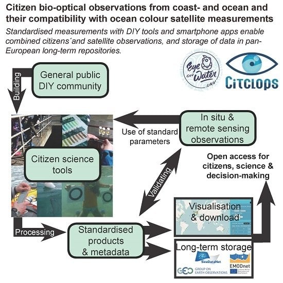
2. Showcase and Results for Coast and Ocean Optical Monitoring in the Citclops Project

2.1. Technologies, Effort, and User Groups

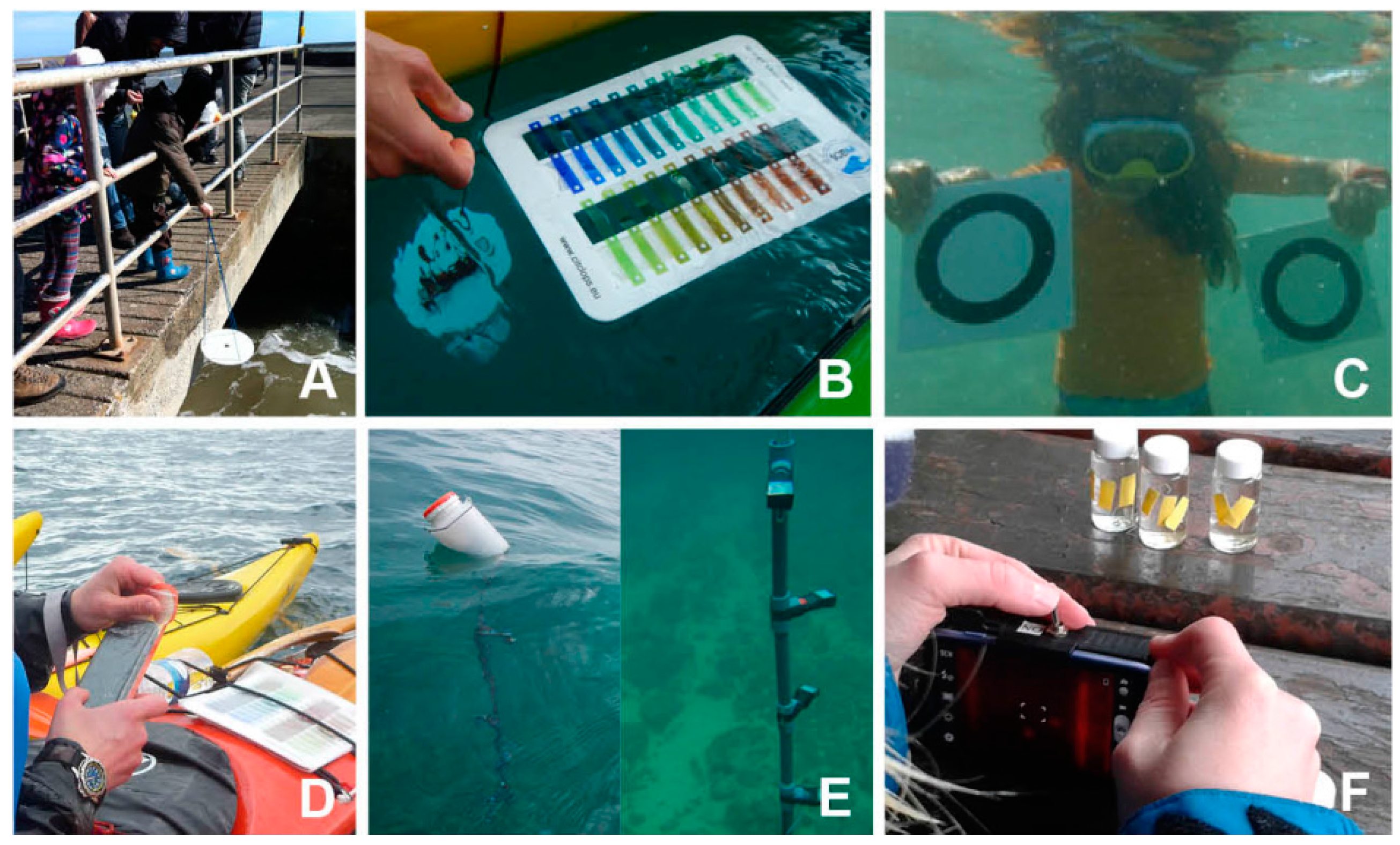
2.1.1. Data Collection with Smartphone App: EyeOnWater-Colour

The EyeOnWater-Colour app was developed for a rapid assessment of surface water colour with smartphones as sensor systems (Table 1, Figure 1). The app guides the user to take an image of the water surface with the integrated smartphone camera by complying with basic quality control issues (flat angle to water surface and correct position of sun for sun-glint minimization). Water colour is assigned to one of 21 colours, which are based on the well-described Forel-Ule water colour comparator scale [27]. Image and colour selection are then uploaded to the EyeOnWater server. Within the Citclops project, a first version of this app (Citclops water colour app) was developed by the inclusion of citizen’s opinions during workshops. After a silent release to the Google Play store and iOS Appstore in April 2014, this app was used and presented to citizen groups during public in September 2015 and has been upgraded since.
Until June 2016 more than 1600 valid datasets, meaning those of the water surface, were taken worldwide and in a constant manner (data accessed at project website [31]). Of these, more than 90% were located within 1 km from the shoreline. No additional tools are necessary to use this app and it is hence widely applicable by persons with access to the ocean, rivers, or lakes.

2.1.2. Data Collection with Tools: Secchi Disk, Revised Forel-Ule Scale, and TrandiCam

During the Citclops project, a choice of measurements between two traditional tools for marine bio-optical observations was offered for the public: The Secchi disk for water transparency measurements (Ø 30 cm, white disk), as well as a newly developed plastic (instead of liquid in glass vials) version of the Forel-Ule water colour comparator scale (Atelier VIX, Amsterdam, The Netherlands) (Table 1, Figure 1). The EyeOnWater-Colour app serves as a digital logsheet for observations with the Secchi disk and the Forel-Ule scale, as it allows manual input of Secchi depth and Forel-Ule colour during the course of regular colour measurements. Both instruments were freely distributed, and used mainly by environmental groups for measurements and educational purposes, as well as by water sports groups and professional sailors. In total, 98 Secchi disk- and 42 Forel-Ule measurements were conducted during and after the Citclops project phase (data accessed at [31]).
A new measurement with equally low technical prerequisites is the TRANsparency unDerwater Index based on Citizen cAMera pictures (TrandiCam), for horizontal water transparency measurements (Table 1, Figure 1). For the TrandiCam, two small white plastic plates (approx. 25 × 25 cm) with a black open circle (Ø 9 cm) and a waterproof camera are needed. Measurements are conducted by taking underwater photos of the two submerged plates which are held at a distance of about 1 m. The calculation of water transparency from the photo is performed in subsequent post-processing [29]. This is currently performed manually by scientists, but a beta version of a public platform is being tested. Hence, this system is well suited for a user group of divers, such as scuba divers or snorkelers, but also swimmers. It has been successfully tested in scientific summer camps with children and in summer scientific guided diving as well as with individual volunteers. Its main advantages are the intuitive concept behind transparency (or visibility) underwater, which is of direct interest for the potential user group as a near real-time transparency index along the coasts is useful for them to decide where to dive. There is a record of 350 measurements with TrandiCam, which were conducted during and after the project phase.

2.1.3. Data Collection with DIY Tools: KdUINO and SmartFluo

The KdUINO buoy was developed for continuous measurements of vertical light attenuation throughout the water column, similar to the standard bio-optical parameter diffuse attenuation coefficient (Kd) (Table 1, Figure 1). It is a moored system with a set of sensors that retrieve the decrease of light over depth in the water column. KdUINO is made as a Do-It-Yourself (DIY) kit with open hardware, firmware, and software (hermetic bottle of approx. 25 × 15 cm and light collector chain of variable length, 50 €) [28]. Its main components are a set of four to six encapsulated low-cost photonic sensors and an Arduino board (an open hardware platform) as interface electronics, with a real-time clock for data acquisition. The instrument was completed with a mobile application which allows for the collection of KdUINO data remotely [28]. When a connection is available, the data are sent to a server. Data from buoys set up in lakes or on the coast for validation and/or data retrieval can be seen in real time on an interactive map [32].
The ease of use of the DIY concept for KdUINO was successfully tested with young children in school classes. Participants of the DIY events were motivated to acquire new skills in the field of technology, and transversally, about the environment and biology. The use of the Arduino and DIY concepts opens two potentially interested large user groups whose members may extend their interest from technology to environmental issues. The KdUINO measurements were conducted at 117 locations, both during and after the project phase.
While the above described tools are used to collect bulk optical parameters of substances in water, fluorescence is a powerful tool for substance specific measurements. In Citclops, a smartphone adapter for fluorescence measurements of the algal pigment Chl a was developed (SmartFluo) (Table 1, Figure 1). The smartphone camera is used as a signal detector. The system can be operated via a smartphone app and delivers an red-green-blue (RGB)-image which is then turned into a numerical value by the newly developed RGB2Fluo algorithm [30]. The integration of the app automatically delivers relevant metadata, such as position, time, and illumination-time of the water sample, while sampling depth (m) is included by the user.
The SmartFluo is an affordable (35 € + 3-D print of approx. 10–50 €) and handy device (dimensions without smartphone: 12.0 × 7.5 × 3.7 cm; weight: 126 g), composed of a 3-D printed plastic housing with optical assets such as a small mirror and LED (Light Emitting Diode), and an electronic operation unit [30]. The housing can be attached to a regular smartphone. DIY instructions on how to build and use the SmartFluo are freely available for the public on the project website [24].
The specificity towards the target substance make the SmartFluo an interesting tool for environmentally engaged groups and water quality monitoring institutes. Different components of the adapter address specific communities, such as the 3-D printing community (open labware- and maker movement) that can adapt the housing to different smartphone types or to additional parameters. The adapter has been used under guided conditions (by researchers) during citizen training events of the project, e.g., at a sea kayak workshop in Llançà, Spain (31 March–1 April 2015), Blue Info Days in Wexford, Ireland (24–26 April 2015), Ocean Sampling Day (21 June 2015), and during scientific research campaigns.

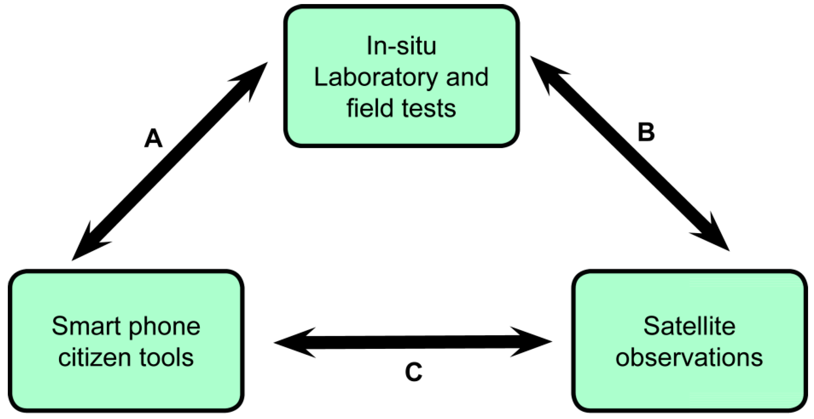
2.2. Quality Control and Compatability to Common Coast and Ocean Remote Sensing Parameters

All described outputs of citizen science tools are directly comparable to products of optical remote sensing sensors (Table 2). The standard products of ocean colour instruments are based on the calculated water leaving radiance or remote sensing reflectance (Rrs) and the derived inherent optical properties of water (IOP) that describe the attenuation by absorption (a), scattering (b), and total attenuation (c = a + b m−1) at each wavelength (λ). These quantities that describe the incoming and outgoing light field are combined in simple blue-green ratio or more complex semi-empirical algorithms to estimate the substance composition in water (Chl a), suspended particulate material (SPM), and coloured dissolved organic matter (CDOM)) [33,34,35,36]. A very short resume of products involved is given in the last column of Table 2.
Product categories to assess substance composition and concentration in Citclops embraced ocean colour, water transparency, and fluorescence. For quality control and validation of these products, three relationships can be established between citizen tools, satellite data, and traditional in situ measurements (Figure 2). Most important for Citclops/EyeOnWater are direct relations of citizen tools to in situ laboratory and field tests (A); similar to those applied to remote sensing products in validation campaigns (B); which allow a direct comparison to satellite observations (C). To explore relation (A), all citizen tools and products were thoroughly tested with standard in situ and laboratory equipment.
Despite the name “ocean colour sensors”, the analysis of satellite data has not yet paid attention to colour as an integral optical property that can also be retrieved from multispectral satellite data. Because colour can be quantified accurately by citizen tools, both by visual comparison with the Forel-Ule scale or directly from digital images [26], research was initiated in the Citclops project to develop a new remote sensing colour product from satellites. Van der Woerd and Wernand [8] demonstrated that colour, expressed mainly by the hue angle (α), can be derived accurately and consistently from Sea-viewing Wide Field-of-view Sensor (SeaWiFS), Moderate Resolution Imaging Spectroradiometer (MODIS), MEdium Resolution Imaging Spectrometer (MERIS), and Ocean and Land Colour Instrument (OLCI) data. The algorithm consisted of a weighted linear sum of the remote sensing reflectance in all visual bands plus a correction term for the specific band-setting of each instrument. Thus a new product was derived that allowed for a direct comparison between satellite data and citizen tools. The very good compliance of in situ data as would be derived by citizens and MERIS data for this parameter was shown in field tests in the Ebro Delta, NW Mediterranean [37]. The hue angle can be directly converted to the Forel-Ule colour [8].
Both hue angle and Forel-Ule colour are a direct result of the use of the EyeOnWater-Colour app. Here, the internal camera of the smartphone functions as the sensor. The primary output of these devices is an RGB image in *.jpg or *.png format, which is converted to the desired parameter by the use of a newly designed algorithm and a user based comparison of water colour with an in-app colour comparison scale. Incoming images are processed on the EyeOnWater server. Water colour, expressed as a Forel-Ule colour classification, is converted from the RGB image by means of the WAter COlor from Digital Images (WACODI) algorithm [26], and is compared with the user-based value. Comparisons with measured (Forel Ule plastic scale) and WACODI calculated images derived by the app by citizens resulted in a very good fit (R² = 0.89) [26]. WACODI includes a range of flags for quality control, gamma correction, and an automated selection of the image fraction which best represents water colour. The conversion of the RGB image to Forel-Ule colour is based on a transversion of the CIE colour spectrum via tri-stimulus values and calculation of the hue angle (α), which is then matched to the respective hue angle range of the Forel-Ule scale. The compliance to such spectral information was demonstrated by a very good fit of the app data to reflectance spectra from in situ sensors (R² = 0.98) [26].
Traditional oceanic measurements with the Secchi disk and the original or plastic Forel-Ule colour comparator scale can be added as an additional value in the expert modus of the EyeOnWater-Colour app, and allows for a direct comparison to described remote sensing products.
One of the oldest observations of light attenuation in water, for scientists and citizens alike, is the Secchi disk depth [38]. The observation is simple, low-cost, and has high accuracy. This observation relies on the human perception and is somewhat dependent on the solar elevation in a clear sky [39] and not on an inherent optical property of water. Additionally, the diffuse downward irradiation attenuation coefficient (Kd) is not an IOP at each (λ) or integrated over the visual wavelengths 400–700 nm (Photosynthetically Available Radiation, PAR). There is a dependency on depth and the spectral and intensity distribution of the incoming light field [40]. Fortunately, standard products have been developed and tested for many aspects of light attenuation, such that for OLCI, the IOPs (a, b, c) are derived, together with Kd, Kd over PAR, and Secchi disk depth [33]. Although the product for Secchi depth is semi-empirical [10], it is clear that this product makes the simplest direct coupling with citizen observations.
Water transparency measurements with the KdUINO are received with a smartphone app, which includes a calibration of the different light collectors towards the strongest signal reached in the measurement [28]. The KdUINO measures the attenuation of diffuse downwelling radiation over a large wavelength range that is not exactly identical to PAR. Bardaji et al. [28] demonstrated that despite aspects of the wavelength dependency of Kd that come into play, a good relation with Kd measurements by the PR-800 Profiling Reflectance Radiometer (Biospherical Instruments Inc., San Diego, CA, USA) was reached (R2 = 0.96) [28]. Additionally, the TrandiCam measurement results in an image, which can be captured with a waterproof smartphone, but also with any other underwater camera. After a manual upload of the image to the project website, transparency is calculated with the novel TrandiCam algorithm [29]. What is special about the Trandicam measurement is that it allows both the measurement of the total attenuation coefficient (c) and the vertical attenuation coefficient (Kd); see Zaneveld and Pegaru [41]. TrandiCam was successfully compared to KdUINO and commercial instruments in a controlled environment and also compared in the sea.
The concentration of Chl a in the water is an indicator of the standing stock of primary producers. Indeed, the incentive to launch ocean colour imagers into space was mainly driven by the quest for the global distribution of algae in the oceans. In the oceans, the pigments of algae are the main colorants, and band-ratio algorithms that use the remote sensing reflectance at blue to green wavelengths are successful with a mean accuracy of around 30% (open ocean) and 70% (coastal areas) [33].
The Smart Fluo instrument detects the fluorescence light around 685 nm. Fluorescence is a relatively weak signal and rest product (1%–3%) of the light harvested in algae. Nevertheless, this signal can be locally and temporarily coupled linearly to the concentration of pigments. That is why commercial in situ measurements are based on fluorescence [1]. However, frequent calibration is always required. In the SmartFluo, the internal camera of the smartphone functions as the sensor. Algal fluorescence pictured on the RGB image is converted to algal concentrations with the novel RGB2Fluo algorithm [30]. Measurements of the target parameter, Chl a concentration (mg·m−3), with the SmartFluo and with an off-the-shelf fluorometer (LS55, PerkinElmer Ltd., Waltham, MA, USA) resulted in a very good comparability (R² = 0.97) [30].
Instruments such as OLCI have a band setting that allows the detection of radiation related to the fluorescence emission. Although some articles have been published that make active use of this signal [42], the interpretation remains problematic due to problems with the atmospheric correction, inaccuracies in the baseline correction, and many effects in the algae themselves that have an impact on the detected signal and correlation with Chl a, e.g., [43]. Therefore, a straightforward comparison of the signal strength detected by the SmartFluo and the fluorescence line height of the OLCI is not simple, and it is proposed to use the concentration of Chl a as the main product that can be compared.
The measurements and smartphone apps are designed in such a way that observations and the follow-up processing are standardized, and independent of the observer. For example, the picture for derivation of the water colour can only be taken when the camera is pointed in the right direction. This results in measurements with compatible quality within a sensor’s dataset.

2.3. Use of Standard Vocabulary

To facilitate the comparability to standard coast and ocean measurements, including that of space-borne data, Citclops tools and methods were designed in compliance with standard vocabularies of the Natural Environment Research Council (NERC) Vocabulary Server (NVS) 2.0. For parameter classification, the controlled terms lists P01 and P02 [44,45] were used (Table 2). Desired adaptation of existing vocabularies to the needs for citizen science data were communicated with SeaDataNet, to include required data from citizen science tools, if necessary. Changes to vocabularies were made for the conversion of RGB images to a Forel-Ule colour comparator digit. Likewise, SeaDataNet device categories (L05) were added, such as 304: ocean colour radiometers [46].
All Citclops/EyeOnWater data are collected in a format that captures data in a standardized way, as required by national and international data centres. To support automated data discovery and visualisation, a metadata format was developed and data flow from the source to the user was implemented in Citclops/EyeOnWater. For the definition of the metadata format, the SeaDataNet ISO19115 compliant CDI (common data index) metadata profile was taken as the basis, as shown for the case of EyeOnWater-Colour app measurements (Table 3). Quality control for metadata, such as latitude in the range −90 to 90, longitude between −190 and 180, or date and time validity, is described in the SeaDataNet quality control procedures [47], and already adopted in the Citclops/EyeOnWater-Clour app. The compliance with metadata and data standard requirements and the use of common vocabularies qualifies Citclops/EyeOnWater data for archiving datacenters connected to European infrastructures, such as SeaDataNet and EMODnet. All metadata that are required for upload to SeaDataNet CDI format are stored in an XML (Extensible Markup Language) file.

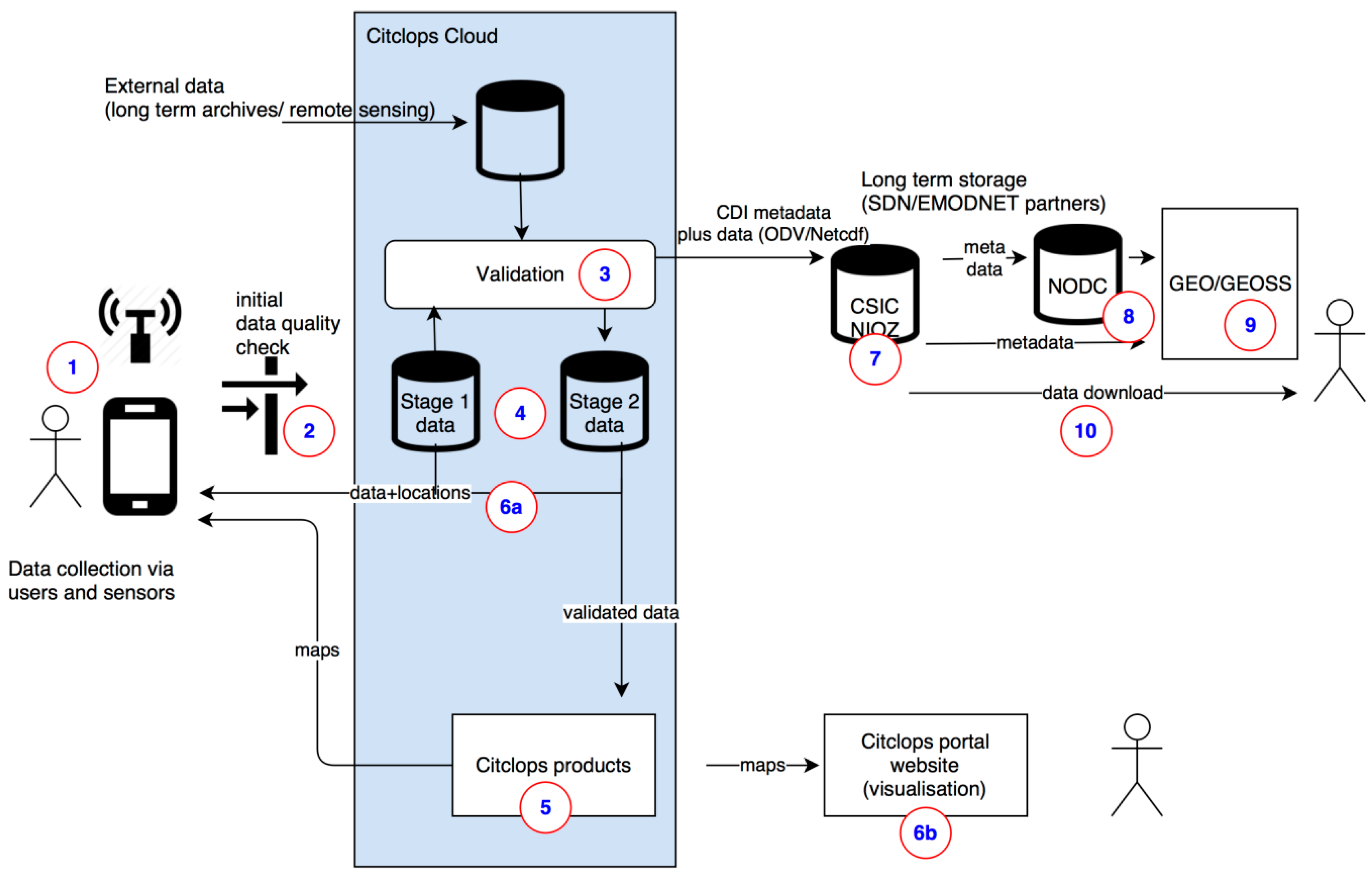
2.4. Data Infrastructure, Visualisation, and Access

Data collected with the tools are sent to the central project server. In the following, the data flow is outlined from data collection to visualization and long-term archiving (Figure 3). Examples of the EyeOnWater-Colour app are provided:
  • Collection of raw data with low-cost tools, including the automatic addition of metadata with apps by use of the standard vocabularies of SeaDataNet. Data are then sent to the project server: RGB image of water surface and metadata file with user selection of water colour.
  • Quality control of the measurements and metadata: if possible with the user’s entry and other sources: Colour is calculated from the RGB image and can be compared to user selection. Other sources may include remote sensing data.
  • Storage of data on central web server. EyeOnWater data are stored at the EyeOnWater server hosted by MARIS.
  • Visualisation of measurements and comparison to other data. The app and processed data are shown on the project websites, and can be compared to historical datasets of water colour [25,31]. Both sites are linked and can be extended for new parameters in the future.
  • Long-term storage and accessibility of the data: Data are stored in a harmonized format that allows upload to international data centres, such as SeaDataNet and EMODnet. EyeOnWater-Colour data are stored in GEOSS.
The import of the data to a central web server is fully automated. The EyeOnWater-Colour data are transferred by the app to the central server as a zip file with the image and metadata XML file. Data are unpacked and uploaded with a PHP batch script. Syntax, as well as content metadata, are parsed and checked. Data are then modeled from the database into maps for geographic representation and this allows for immediate actions by the user on [25]. For immediate free access to the data, users are guided to a download-web-application based on PHP, OpenLayers3, and jQuery. Here, the data can be searched and downloaded for specific selection using geographical, date-time and parameter facets [31] (Figure 4).
Data transfer to data centres can be facilitated by export with the SeaDataNet Mikado software to create CDI entries for new observations. Citclops/EyeOnWater data, as well as the historic Forel-Ule colour comparator datasets were published via WMS/WFS services to the GEO/GEOSS portal (see [48]). Access to data is open and users can download them from the project webpage and from the EMODnet/SeaDataNet or GEOSS portals in a standard format. The presented system is available in any country and, thanks to interoperable standards, easily linked to other communities.

3. Discussion

The rise of affordable tools for coast and ocean investigations, combined with metadata information, opens the door to a new realm of spatial data and services for science and citizen engagement.
By offering different levels of effort and technical complexity, tools become attractive for different user groups. The lowest technical engagement-barrier is certainly provided by easy to use apps that require nothing more than a smartphone with its integrated sensors such as GPS and its camera. Apps such as the EyeOnWater-Colour app are used by very different users, from people with only sporadic access to the sea, up to environmentally engaged groups (e.g., Coastwatch, Ireland). The easy and rapid measurement-process makes this app attractive for people that are not necessarily interested in becoming more engaged in environmental monitoring. This entryway by simple apps can, however, easily lead to an increased interest to broaden environmental knowledge and to use more complex tools. A similar pattern has been observed in the MyOSD (My Ocean Sampling Day) project, in which citizens started to contribute to scientist’s microbial sampling by observations of contextual environmental parameters, and followed by citizen’s demands in the subsequent year by microbial sampling with specialized sampling kits [49].
The use of simple, yet standardised instrumentation poses an increased level of complexity and effort to environmental observations. In Citclops, such tools include the Secchi disk (Ø 30 cm, plain white), plastic Forel-Ule scale (plastic plate with pre-determined colour strips), or TrandiCam (white plates with black open circle Ø 9 cm). While this equipment is neither expensive nor requires technical skills and knowledge, citizens need to acquire or build it, and bring it to the sampling area. In Citclops/EyeOnWater, this increased effort is mirrored by the total number of archived measurements with the EyeOnWater-Colour app, which is with 1600 image uploads much higher than for 98 Secchi depthmeasurements. While the differences in these total numbers are not directly comparable, as the app’s primary purpose is the recording of water colour, it is more than likely that the increased participants’ effort for Secchi measurements plays a major role. Nonetheless, all three medium-effort tools of Citclops are used by the public, as shown by these Secchi and Forel-Ule scale uploads via the app. Of note is the use of tools by members of water sports groups, such as divers in the case of the TrandiCam. Sports- and professional groups are also named as users in other projects, such as sailors, divers, and fishermen in the Secchi disk project [12]. Hence, these medium-effort tools are valuable to not only engage citizens, but also to address different user groups in citizen science.
An even higher obstacle for participation is posed by DIY tools for which participants need to order components to construct instruments themselves, and for which knowledge and technical skills are required. The novel KdUINO and SmartFluo are in a low-cost price range (50–100 EUR depending on the setting), but both are examples of such complex tools. Yet, the challenging DIY concept also holds opportunities to attract users other than already environmentally engaged ones: for the KdUINO, the physical computing platform used, Arduino, has many enthusiasts [50]. The SmartFluo is attractive for a large community that is dedicated to 3-D printing of lab equipment (open labware), and also for the maker movement; a technically oriented portion of the DIY movement [20]. These communities may be purely interested in an adaption of the 3-D printed housing to new smartphone types, or for an inclusion of additional parameters. The files and designs of these movements are shared on 3-D printing [51,52], or open labware and hardware community websites [53,54]. The construction of devices on a DIY basis is an incentive to use them, and thereby to engage in environmental monitoring. In addition, KdUINO and SmartFluo are attractive for scientists or environmentally engaged groups that are interested in specific measurements of Kd or Chl a with low-cost instrumentation.
An increased effort for measurements does apparently not dissuade the public from participation. Indeed, the KdUINO is used by the general public after the Citclops project phase. Another example is the MyOSD project. Here, kits for microbial sampling are distributed to and used by the public, despite an increased effort to take the samples (up to 1–1.5 h of water filtration through syringes) [49]. These findings not only underline the diversity of groups that are motivated to participate by building, applying, and adapting tools for citizen science in open access environments. They also demonstrate that tools with such diverse levels of complexity are used and that an increased effort does not impede citizen engagement.
All techniques developed in Citclops/EyeOnWater are based on basic parameters for coast and ocean remote sensing. Pre-requisites for a relation of citizen data to space-borne remote sensing were accomplished by thorough testing of the relationship of citizen tools to sensitive professional equipment and quality control. This resulted in a very good compliance for water colour (R2 = 0.98), transparency (R2 = 0.96), and fluorescence measurements (R2 = 0.97) [26,28,30]. Quality procedures as applied for Citclops/EyeOnWater tools are implemented in an automated way wherever possible. Nonetheless, errors by the incorrect use of instrumentation are possible, e.g., when images with bottom visibility are taken that corrupt the colour of water with the EyeOnWater-Colour app. Elimination of these images is realized by user detection and subsequent deletion of the images by an expert (compare the “Flag this” option in Figure 4B,C).
All parameters can be connected to established remote sensing products of different missions. The ocean colour type of instruments in space (SeaWiFS, MODIS, MERIS, Sentinel-3) are multispectral sensors with dedicated narrow (10 nm) wavelength bands in the visual and near infrared ranges. The band settings are optimized for atmospheric correction and retrieval of algal pigments (indicated by Chl a), SPM, and CDOM [55].
Four key aspects are discussed to describe the compatibility of satellite ocean colour instruments and citizen observations from coastal waters: products, time series, spatial resolution, and validation.
First, standard (and new in case of the hue angle) satellite products for all types of citizen tools developed in Citclops/EyeOnWater exist (Table 2), and enable a direct comparison and co-use of citizen and satellite data. As an example, the Forel-Ule colour can be calculated from spectral signals of past (SeaWiFS, MERIS) and present (MODIS, OLCI) remote sensing sensors [8]. Comparisons of Forel Ule and hue angle data with MERIS data complied well with in situ data in a recent study, in which the complementarity and potential of combined citizen and satellite observations were also outlined [37].
Second, there is a large spatial complementarity of citizen- and satellite measurements. While optical remote sensing often fails in near-coast environments, due to interferences from land and sea bottom visibility, citizens are most likely to conduct measurements in this zone, as reflected by the global data coverage from 26 months of the Citclops/EyeOnWater-Colour app operation. Here, more than 90% of the 1600 received data were situated within 1 km from the shoreline and reveal the more coastward application of this technology. The spatial complementarity was shown by observations of water colour in shallow near-coast areas, in which point samples succeeded where space borne measurements failed [37]. This pattern was also reflected in other citizen science studies, e.g., the MyOSD, in which nearly 80% of quasi-simultaneously collected temperature data by citizens were not covered by satellite or in situ systems [16].
Third, citizen and satellite data also complement each other well on the temporal axis, as shown by Busch et al. [37], where short term dynamics of water colour were better displayed by ground rather than space-borne measurements. Citizen data can, however, also contribute to long-term time series, as demonstrated by the Secchi Dip-In. At present, the Dip-In database has grown to more than 41,000 records on more than 7000 separate waterbodies, not including different sites, such as along rivers and estuaries [56]. Now it is considered a reference database for monitoring transparency as an essential parameter of water quality. More than 140,000 citizen monitoring Secchi depth values since 1983 aided the identification of water clarity patterns in eight states of the USA [14] and underlined the impact of citizen data for water quality monitoring.
Last, satellite data can be used to cross-check citizen data on the ground, or in contrast, high quality citizen science data can be applied for calibration and validation of remote sensing data. A general feasibility of both methods has been shown for water temperature [15,16]. The in situ validation in complex coastal waters based on citizen science tools could be a new cost-effective way of obtaining and processing reference field data.
Marine observations by citizen science will in most cases not deliver as precise data as those achieved with finely calibrated scientific tools. Nevertheless, it is important to take into account that the number of in situ observations that can be retrieved with citizen science approaches could be much larger than those obtained with scientific instruments. In some cases, particularly for identifying complex patterns, large numbers of inaccurate measurements may provide better characterization than scarce precise observations, as it is shown in Figure 5. A thorough description and record of applied tools, methods, and quality control, sketches possibilities and limitations of citizen’s datasets and possible use scenarios, and hence increases their value.
In Citclops, it was clearly shown how citizen data collection and data compatibility for earth observations can be supported by emerging technologies. First, the use of mobile devices as sensor systems allows for automated quality control measures. This is shown for the EyeOnWater-Colour app that automatically guides users through several quality control steps. Second, an automatic inclusion of basic metadata (location and time) by mobile devices delivers data of validated quality and saves effort for the user. Third, the output of such devices can be prepared in a way that complies with international data standards. The output of Citclops/EyeOnWater devices is already designed with common vocabularies when sent to the project database. These include all necessary measurement- and metadata descriptors and comply with the required format for a direct and facile transfer to international data archives, such as EMODnet, SeaDataNet, and GEOSS. Applying this format allows the seamless uptake of citizen data by the data centres as additional source of research data.
The use of standard vocabularies does not only allow the supply of data and metadata to data centres in a harmonised format, with minimised additional costs for conversion and quality control. It also supports the interoperability and re-usability of data, which is a critical issue for citizen science, as identified during the Citizen Science and Smart Cities Summit [57]. By complying with international standards and by transferring data to international data centres, data availability is secured beyond project lifetimes. Certainly, the use of internationally compatible standards is neither feasible nor desirable for all marine citizen science projects, but it should be evaluated with respect to best practices in data management.
Citclops/EyeOnWater is clearly a best practice example for data standardization by use of international protocols in marine citizen science. One of the few additional examples is MyOSD, which is adapted to the scientific OSD project’s data management procedure. OSD’s oceanographic and microbial sequence data are stored in respective data centers, and (physical) samples are bio-archived in the Smithsonian Institute [58].
Such standardised documentation procedures facilitate interpretation of data and information delivery of marine as well as terrestrial citizen science data. This in turn can lead to a use of citizen based data collections, combined with remote sensing observations, to support policy, research, and society.
What all marine citizen science tools have in common is a link to important background knowledge about coast and ocean ecosystems. By covering different user groups with the applied technologies, knowledge and interest about ocean processes may be raised. With a given comparability, measurements can be set in relation to existing datasets, and the measured parameters can be explained in relation to environmental processes. This awareness may lead to environmental stewardship and trigger the raise of citizen’s own questions.

4. Conclusions

In this article, a review of tools and methods that facilitate the collection of optical characteristics of natural waters by citizens (and scientists) was presented. These tools are based on remote sensing principles that are employed by ocean colour Earth observations, and include measurements of water colour, transparency, and fluorescence.
Before citizen’s observations are accepted and used, it is important to validate these with standard measurements in the lab and in the field, and to publish the results in open peer-reviewed literature. This will increase the awareness of the strong and weak points of these “new” observations and their actual use by scientists and water managers. In the EU Citclops project, this quality control and standardization has been taken as a corner stone, which has resulted in numerous articles with many more in the pipeline [26,27,28,29,30,37], and demonstrates the high quality of data derived with these tools as compared to standard in situ or laboratory measurements (water colour R2 = 0.98; transparency R2 = 0.96; Chlorophyll a fluorescence R2 = 0.97) [26,28,30].
The tools and infrastructures of the Citclops/EyeOnWater project are ready to support global spatial data retrieval with combined space-borne observations. Data management, including automated data quality assurance, is essential, both for the acceptance of citizen contributions as additional sources of research data, as well as for interoperability with other domains. The compliance with international standards allows for long-term storage in international data centers, and hence open accessibility and re-use of the data by citizens, scientists, and decision-makers. Future efforts should be directed to case studies for the applications and amendment of these tools to answer scientific questions, as well as on the complementary use of citizen’s and satellite data. By showing examples and positive results, the uptake of citizen science data to support authoritative data is more likely.
By addressing large communities, such as in the Arduino, DIY-, and open labware movements, the culture of re-use and sharing is also demonstrated for technologies. In addition, new user groups for marine environmental observations are addressed by this approach. Thereby, citizen science tools provide a new means for different groups of the public to be informed and to eventually get engaged in environmental stewardship. These show a broad range of possibilities that citizen science offers to explore the yet unknown but crucial functions of aquatic ecosystems, and to participate in a framework of scientific observations, environmental management, and policy making.

Acknowledgments

The Citclops project received funding by the EC-FP7 Programme, grant agreement No. 308469. In particular, the authors thank all citizens and project supporters for their valuable suggestions on modifications of the tools during workshops and training events.

Author Contributions

The EyeOnWater-Colour app was developed M.W., and P.T., KdUINO by R.B., TrandiCam by C.S., SmartFluo by A.F., J.A.B., and O.Z. Data interoperability and quality control were contributed by J.A.B., P.T., L.C., J.P., and H.J.v.d.W. J.A.B. designed and wrote the paper, with contributions from all authors.

Conflicts of Interest

The authors declare no conflict of interest. The founding sponsors had no role in the design of the study; in the collection, analyses, or interpretation of data; in the writing of the manuscript, and in the decision to publish the results.

Abbreviations

The following abbreviations are used in this manuscript:
BODCBritish Oceanographic Data Centre
Chl aChlorophyll a
CDICommon Data Index: Metadata index for data files used in SeaDataNet
CDOMColoured Dissolved Organic MatterCitclops: citizens’ observatories for coast and ocean optical monitoring
DOIDigital Object Identifier
EMODnetEuropean marine observation and data network
ESAEuropean Space Agency
GEOSSGlobal Earth Observation System of Systems
GPSGlobal Positioning System
IOPInherent Optical Property
LEDlight emitting diode
MERISMEdium Resolution Imaging Spectrometer
MIKADOSeaDataNet software for generating metadata
MODISModerate Resolution Imaging Spectroradiometer
MyOSDMy Ocean Sampling Day
NASANational Aeronautics and Space Administration
NERCNatural Environment Research Council
NVSNERC Vocabulary Server
OLCIOcean and Land Colour Instrument
PARPhotosynthetically Available Radiation
PHPServer-side scripting language designed for web
RGBRed-Green-Blue
SPMSuspended Particulate Matter
SeaWiFSSea-viewing Wide Field-of-view Sensor
TrandiCamTRANsparency unDerwater Index based on Citizen cAMera pictures
WACODIWAter COlor from Digital Images development
WMS/WFSWeb Map Service/Web Feature Service
XMLExtensible Markup Language

References

  1. Zielinski, O.; Busch, J.A.; Cembella, A.D.; Daly, K.L.; Engelbrektsson, J.; Hannides, A.K.; Schmidt, H. Detecting marine hazardous substances and organisms: Sensors for pollutants, toxins, and pathogens. Ocean Sci. 2009, 5, 329–349. [Google Scholar] [CrossRef] [Green Version]
  2. Busch, J.A.; Cembella, A.D.; Zielinski, O. Bio-optical approaches for the operational assessment of harmful algal blooms. In Subsea Optics and Imaging; Watson, J., Zielinski, O., Eds.; Woodhead Publishing: Cambridge, UK, 2013; Volume 46, pp. 171–212. [Google Scholar]
  3. Assmy, P.; Smetacek, V. Algal blooms. In Encyclopedia of Microbiology; Schaechter, M., Ed.; Elsevier: Oxford, UK, 2009; pp. 27–41. [Google Scholar]
  4. Tulloch, A.I.T.; Possingham, H.P.; Joseph, L.N.; Szabo, J.; Martin, T.G. Realising the full potential of citizen science monitoring programs. Biol. Conserv. 2013, 165, 128–138. [Google Scholar] [CrossRef]
  5. Mueller, J.L.; Morel, A.; Frouin, R.; Davis, C.O.; Arnone, R.; Carder, K.L.; Lee, Z.; Stewart, R.G.; Hooker, S.B.; Mobley, C.D.; et al. Radiometric Measurements and Data Analysis Protocols; NASA/TM-2003-211621/Rev4; Mueller, J.L., Fargion, G.S., McClain, C.R., Eds.; NASA Goddard Space Flight Center: Greenbelt, MD, USA, 2003; Volume 3. [Google Scholar]
  6. Sentinel 3 OLCI Document Library. Available online: https://sentinel.esa.int/web/sentinel/user-guides/sentinel-3-olci/document-library/ (accessed on 29 July 2016).
  7. Wernand, M.R.; van der Woerd, H.J.; Gieskes, W.W.C. Trends in ocean colour and chlorophyll concentration from 1889 to 2000, worldwide. PLoS ONE 2013, 8, e63766. [Google Scholar] [CrossRef] [PubMed]
  8. Van der Woerd, H.J.; Wernand, M.R. True colour classification of natural waters with medium-spectral resolution satellites: SeaWiFS, MODIS, MERIS and OLCI. Sensors 2015, 15, 25663–25680. [Google Scholar] [CrossRef] [PubMed]
  9. Stock, A. Satellite mapping of Baltic Sea Secchi depth with multiple regression models. Int. J. Appl. Earth Observ. Geoinform. 2015, 40, 55–64. [Google Scholar] [CrossRef]
  10. Doron, M.; Babin, M.; Hembise, O.; Mangin, A.; Garnesson, P. Ocean transparency from space: Validation of algorithms estimating Secchi depth using MERIS, MODIS and SeaWiFS data. Remote Sens. Environ. 2011, 115, 2986–3001. [Google Scholar] [CrossRef]
  11. Lorenzen, C.J. A method for the continuous measurement of in vivo chlorophyll concentration. Deep Sea Res. 1966, 13, 223–227. [Google Scholar] [CrossRef]
  12. Secchi Disk—The Global Seafarer Study of the Phytoplankton. Available online: http://www.secchidisk.org (accessed on 28 July 2016).
  13. Canfield, D.E.; Brown, C.D.; Bachmann, R.W.; Hoyer, M.V. Volunteer lake monitoring: Testing the reliability of data collected by the Florida lakewatch program. Lake Reserv. Manag. 2002, 18, 1–9. [Google Scholar] [CrossRef]
  14. Lottig, N.R.; Wagner, T.; Norton Henry, E.; Spence Cheruvelil, K.; Webster, K.E.; Downing, J.A.; Stow, C.A. Long-term citizen-collected data reveal geographical patterns and temporal trends in lake water clarity. PLoS ONE 2014, 9, e95769. [Google Scholar] [CrossRef] [PubMed]
  15. Brewin, R.J.W.; de Mora, L.; Jackson, T.; Brewin, T.G.; Shutler, J. On the potential of surfers to monitor environmental indicators in the coastal zone. PLoS ONE 2015, 10, e0127706. [Google Scholar] [CrossRef] [PubMed] [Green Version]
  16. Schnetzer, J.; Kopf, A.; Bietz, M.J.; Buttigieg, P.L.; Fernandez-Guerra, A.; Ristov, A.P.; Glöckner, F.O.; Kottmann, R. Myosd 2014: Evaluating oceanographic measurements contributed by citizen scientists in support of ocean sampling day. J. Microbiol. Biol. Educ. 2016, 17, 163–171. [Google Scholar] [CrossRef] [PubMed]
  17. Myshake. Available online: http://myshake.berkeley.edu (accessed on 28 July 2016).
  18. Ispex-eu 2105. Available online: http://ispex-eu.org/de (accessed on 28 July 2016).
  19. Kuo, Y.-S.; Verma, S.; Schmid, T.; Dutta, P. Hijacking power and bandwidth from the mobile phone’s audio interface. In Proceedings of the First ACM Symposium on Computing for Development, London, UK, 17–18 December 2010.
  20. Baden, T.; Chagas, A.M.; Gage, G.; Marzullo, T.; Prieto-Godino, L.L.; Euler, T. Open labware: 3-D printing your own lab equipment. PLoS Biol. 2015, 13, e1002086. [Google Scholar] [CrossRef] [PubMed]
  21. Kelley, C.D.; Krolick, A.; Brunner, L.; Burklund, A.; Kahn, D.; Ball, W.P.; Weber-Shirk, M. An affordble open-source turbidimeter. Sensors 2014, 14, 7142–7155. [Google Scholar] [CrossRef] [PubMed]
  22. Leeuw, T.; Boss, E.S.; Wright, D.L. In situ measurements of phytoplankton fluorescence using low-cost electronics. Sensors 2013, 13, 7827–7883. [Google Scholar] [CrossRef] [PubMed]
  23. Schade, S.; Tsiinaraki, C. Survey Report: Data Management in Citizen Science Projects; Publication Office of the European Union: Luxembourg, 2016. [Google Scholar] [CrossRef]
  24. CiTCLOPS (Citizens’ Observatory for Coast and Ocean Optical Monitoring). Available online: www.citclops.eu (accessed on 29 July 2016).
  25. Eyeonwater.Org Colour. Available online: www.eyeonwater.org/color (accessed on 28 July 2016).
  26. Novoa, S.; Wernand, M.R.; van der Woerd, H.J. Wacodi: A generic algorithm to derive the intrinsic color of natural waters from digital images. Limnol. Oceanogr. Methods 2015, 13, 697–711. [Google Scholar] [CrossRef]
  27. Novoa, S.; Wernand, M.R.; van der Woerd, H.J. The forel-ule scale revisited spectrally: Preparation protocol, transmission measurements and chromaticity. J. Eur. Opt. Soc. Rapid Publ. 2013, 8, 13057. [Google Scholar] [CrossRef] [Green Version]
  28. Bardaji, R.; Sánchez, A.-M.; Simon, C.; Wernand, M.; Piera, J. Estimating the underwater diffuse attenuation coefficient with a low-cost instrument: The KdUINO DIY buoy. Sensors 2016, 16, 373. [Google Scholar] [CrossRef] [PubMed]
  29. Simon, C.; Bardaji, R.; Piera, J. Underwater Imaging and Citizen Science to Estimate Water Transparency; Blue Potonics 4; European Optical Society: Joensuu, Finland, 2015. [Google Scholar]
  30. Friedrichs, A.; Busch, J.A.; van der Woerd, H.J.; Zielinski, O. Measuring chlorophyll a fluorescence in water by means of smart phones. Limnol. Oceanogr. Methods 2016. submitted. [Google Scholar]
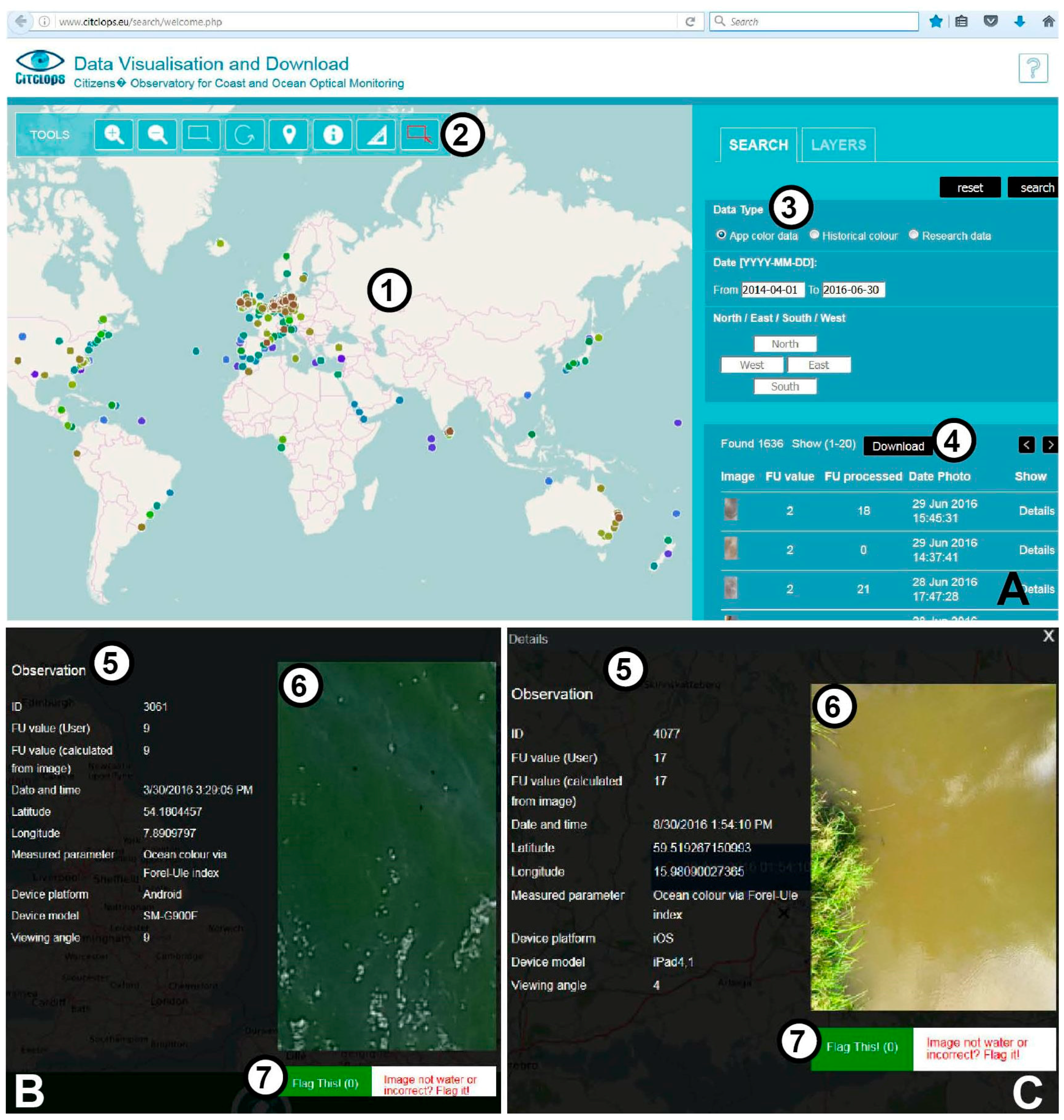
  31. Data Visualisation and Download—Cititzens’ Observatory for Coast and Ocean Optical Monitoring. Available online: http://www.citclops.eu/search/welcome.php (accessed on 28 July 2016).
  32. KdUINOV2 Map of KdUINO Data. Available online: https://bit.ly/kduino (accessed on 25 July 2016).
  33. European Space Agency (ESA). GSC Sentinel-3 PDGS Products Definition; GMES-S3GS-EOPG-TN-12-0004; ESA: Paris, France, 2015; p. 98. [Google Scholar]
  34. Lee, Z.-P.; Darecki, M.; Carder, K.L.; Davis, C.O.; Stramski, D.; Rhea, W.J. Diffuse attenuation coefficient of downwelling irradiance: An evaluation of remote sensing methods. J. Geophys. Res. 2005, 110, C02017. [Google Scholar] [CrossRef]
  35. Van der Woerd, H.J.; Pasterkamp, R. Hydropt: A fast and flexible method to retrieve chlorophyll-a from multispectral satellite observations of optically complex coastal waters. Remote Sens. Environ. 2008, 112, 1795–1807. [Google Scholar] [CrossRef]
  36. Kurekin, A.A.; Miller, P.I.; van der Woerd, H.J. Satellite discrimination of Karenia mikimotoi and Phaeocystis harmful algal blooms in European coastal waters: Merged classification of ocean colour data. Harmful Algae 2014, 31, 163–176. [Google Scholar] [CrossRef]
  37. Busch, J.A.; Price, I.; Jeansou, E.; Zielinski, O.; van der Woerd, H.J. Citizens and satellites: Assessment of phytoplankton dynamics in a nw Mediterranean aquaculture zone. Int. J. Appl. Earth Observ. Geoinform. 2016, 47, 40–49. [Google Scholar] [CrossRef]
  38. Wernand, M.R. On the history of the Secchi disc. J. Eur. Opt. Soc. Rapid Publ. 2010, 5. [Google Scholar] [CrossRef]
  39. Verschuur, G.L. Transparency measurements in Garner Lake, Tennessee: The relationship between Secchi depth and solar altitude and a suggestion for normalization of Secchi depth data. J. Lake Reserv. Manag. 1997, 13, 142–153. [Google Scholar] [CrossRef]
  40. Mobley, C.D. Light and Water: Radiative Transfer in Natural Waters; Academic Press: San Diego, CA, USA, 1994. [Google Scholar]
  41. Zaneveld, R.J.V.; Pegau, W.S. Robust underwater visibility parameter. Opt. Express 2003, 11, 2997–3009. [Google Scholar] [CrossRef] [PubMed]
  42. Behrenfeld, M.J.; Westberry, T.K.; Boss, E.S.; O’Malley, R.T.; Siegel, D.A.; Wiggert, J.D.; Franz, B.A.; McClain, C.R.; Feldman, G.C.; Doney, S.C.; et al. Satellite-detected fluorescence reveals global physiology of ocean phytoplankton. Biogeosciences 2009, 6, 779–794. [Google Scholar] [CrossRef]
  43. Peperzak, L.; van der Woerd, H.J.; Timmermans, K.R. Disparities between in situ and optically derived carbon biomass and growth rates of the prymnesiophyte phaeocystis globosa. Biogeosciences 2015, 12, 1659–1670. [Google Scholar] [CrossRef]
  44. Seadatanet p02—Seadatanet Parameter Discovery Vocabulary. Available online: http://seadatanet.maris2.nl/v_bodc_vocab_v2/search.asp?lib=P02 (accessed on 8 July 2016).
  45. Seadatanet p01—Bodc Parameter Usage Vocabulary. Available online: http://seadatanet.maris2.nl/v_bodc_vocab_v2/search.asp?lib=P01 (accessed on 8 July 2016).
  46. Seadatanet p05—International Standards Organisation ISO19115 Topic Categories. Available online: http://seadatanet.maris2.nl/v_bodc_vocab_v2/search.asp?lib=P05 (accessed on 8 July 2016).
  47. SeaDataNet. Seadatanet Data Quality Control Procedures. 2010. Available online: http://www.seadatanet.org/content/download/18414/119624/file/SeaDataNet_QC_procedures_V2_%28May_2010%29.pdf (accessed on 8 July 2016).
  48. Geoss Resource Details—Citclops Eyeonwater Colour Observations. Available online: http://geossregistries.info/geosspub/resource_details_ns.jsp?compId=urn:geoss:csr:resource:urn:uuid:5dc54869-d8a1-0ee8-d7e6-993a305a310c (accessed on 29 July 2016).
  49. Schnetzer, J. On the Feasibility to Engage Heterogeneous Communities in Data Gathering, Sharing and Enrichment. Ph.D. Thesis, Jacobs University, Bremen, Germany, 2015. [Google Scholar]
  50. Arduino. Available online: https://www.arduino.cc (accessed on 8 July 2016).
  51. Thingiverse. Available online: http://www.thingiverse.com (accessed on 8 July 2016).
  52. Instructables—Share What You Make. Available online: http://www.instructables.com (accessed on 8 July 2016).
  53. Open-Labware.Net 3-D Print Your Own Lab Equipment. Available online: https://open-labware.net (accessed on 8 July 2016).
  54. Plos Collections—Open Source Toolkit: Hardware. Available online: http://collections.plos.org/open-source-toolkit-hardware (accessed on 8 July 2016).
  55. International Ocean-Colour Coordinating Group. Remote Sensing of Ocean Colour in Coastal, and Other Optically-Complex, Waters; IOCCG: Dartmouth, NS, Canada, 2000. [Google Scholar]
  56. The Secchi Dip-in—Volunteers Contributing to Our Understanding of Water Quality. Available online: http://www.secchidipin.org/ (accessed on 26 September 2016).
  57. Craglia, M.; Granell, C. Citizen Science and Smart Cities; European Commission: Luxembourg, 2014; p. 54. [Google Scholar]
  58. Kopf, A.; Bicak, M.; Kottmann, R.; Schnetzer, J.; Kostadinov, I.; Lehmann, K.; Fernandez-Guerra, A.; Jeanthon, C.; Rahav, E.; Ullrich, M.; et al. The ocean sampling day consortium. GigaScience 2015, 4, 27. [Google Scholar] [CrossRef] [PubMed] [Green Version]
Figure 1. Citclops-tools for different user groups as used during public training events. Data collection with (A) Secchi disk in Ireland (A. Friedrichs); (B) Forel-Ule plastic scale in Spain (J. Piera); (C) TrandiCam plates in Spain (C. Simon); (D) Data collection by means of EyeOnWater-Colour app in Spain (J. Piera); (E) Data collection for technically experienced users with KdUINO in Spain (J. Piera); and (F) SmartFluo in Ireland (J. Busch).
Remotesensing 08 00879 g001
Figure 2. Relationships between citizen science tools, in situ measurements with standard equipment, and satellite observations. Citclops/EyeOnWater citizen tools are tested and validated by direct relation to standard in situ- and laboratory measurements (relation A); Which are commonly related to satellite data in big validation campaigns (relation B); By compliance with satellite products, citizen science tools are directly related to satellite observations (relation C), and indirectly via relations A and B.
Remotesensing 08 00879 g002
Figure 3. Data flow to users and external systems for affordable tools developed in Citclops. Data are collected by users with affordable sensors, and are centrally stored in a database for metadata and files. Data are visualized for users in the Citclops/EyeOnWater portal, and then sent to data portals like EMODnet and GEOSS from the Citclops portal or national data centres. Remote sensing data can be integrated as an additional step for validation and/or visualization of the added data.
Remotesensing 08 00879 g003
Figure 4. (A) Affordable tools data visualisation and download website, shown here for EyeOnWater-Colour measurements [31] with a (1) display of data points on a map, (2) spatial data selecion tools, (3) selection of data type (app, historical, research data) and time frame, (4) and a quick view of selected data with download option; (B) Single data points are displayed on mouse click on the EyeOnWater-colour website (screenshot) [25]. (5) Shown observation details include the measured parameter Forel-Ule water colour as determined by the user and calculated from the image, as well as basic metadata, such as sample ID, date, time, location, parameter description, viewing angle and device platform and model, as well as (6) the image of water colour and (7) a Flag this option in case the image is not of water surface; here shown for Android and (C) iOS device.
Remotesensing 08 00879 g004
Figure 5. Example of pattern retrieval of a complex pattern (A) using two different approaches: Based on scientific instruments (B) with high accuracy but low numbers of measurements or based on citizen science approaches (C) with less accuracy but much larger numbers of observations. In this case, the pattern that could be retrieved with citizen science instruments (blue dotted line in (C)) may have better results than the one retrieved with scientific instruments (red dotted line in (B)), taking into account that regression errors from inaccurate measurements would be smaller that interpolation errors from high precision observations.
Remotesensing 08 00879 g005
Table 1. Effort, requirements, and user groups for citizen science tools developed in the project Citclops (Status: 8 July 2016).
Effort and RequirementsProcedureUser Group (Based on Technique)Number of Measurements
Low: EyeOnWater-Colour appTake a photo with the app, compare and select a colour, send data.General public (with smartphone)1600
Medium: Secchi disk (30 cm, white) and smartphoneGet or build Secchi-disk
Submerge Secchi-disk and enter value in EyeOnWater-Colour app
Engaged general public98
Medium: Forel-Ule scale, Secchi disk and smartphoneGet Forel-Ule scale and Secchi disk
Compare water colour of Forel-Ule scale to half-submerged Secchi disk. Enter value in EyeOnWater-Colour app
Engaged general public42
Medium: TrandiCam: two white plastic plates with black pattern and underwater cameraPrepare white disks with black pattern
Hold disks in water and take an underwater photo. Note location and depth. Upload photo.
Engaged divers, snorkelers, swimmers350
High: KdUINO: Several building elements, Knowledge on Arduino, technical skillsOrder elements
Build the KdUINO
Install in water
Return to receive data with a smartphone app.
DIY community
Arduino community
117 (locations with multiple measurements)
High: SmartFluo: Smartphone app, several building elements, knowledge and access to 3-D printerOrder elements
3-D print housing
Build SmartFluo
Fill water in a cuvette and measure fluorescence with a smartphone app. Automated calculation is in development.
Maker movement (3-D printing community)scientist testing only
Table 2. Citizen science tools and standardized vocabulary for EU FP7 Citclops project parameters and their optical remote sensing counterparts.
Citizen Science Tool and ProductP01 (British Oceanographic Data Centre (BODC) Parameter Usage Vocabulary) P02 (SeaDataNet Parameter Discovery Vocabulary)Remote Sensing Reflectance (Spectral Information) Converted to Standard Oceanographic Parameter
EyeOnWater- colour app:
User selected Forel-Ule true colour on RGB-image, converted to hue angle and Forel-Ule classification (by WAter COlor from Digital Images (WACODI) algorithm [26])
P02: R410: Ocean colour and earth-leaving visible waveband spectral radiation
P01: CLFORULE Colour of the water body by visual estimation and conversion to a number on the Forel-Ule scale
Wavelengths → hue angle → Forel-Ule colour [8,37]
Secchi disk & Forel-Ule plastic scale:
White Secchi disk is submerged in water and depth is noted when no longer visible. At half Secchi depth, water colour on white disk is compared to colour comparator scale (Forel-Ule)
Water transparency
P02: SECC: Secchi disk depth
P01: SECCSDNX: Visibility in the water body by Secchi disk
P01: CLFORULE
Wavelengths → Empirical and semi-analytical algorithms → Secchi depth (compare [9,10])
KdUINO
Light availability at different depths on three channels (RGB), converted to light attenuation throughout the water column
Water transparency
(approximate diffuse attenuation coefficient (Kd))
P01: ATTNTZ01: Attenuation (unspecified wavelength) per unit length of the water body by 30 cm path length transparency meter
Wavelength ratio → Kd
Wavelength ratio → Chl → Kd
Wavelength ratio → absorption & scattering → Kd [34]
Secchi depth (vertical transparency) (compare [10])
TrandiCam
RGB image of two white plates with black pattern, converted to distance of plates and horizontal transparency of water on three channels (RGB)
Water transparency
P01: SECCSDNX
Secchi depth (vertical transparency) (compare [10])
SmartFluo
RGB image of red Chl a fluorescence, converted to Chl a concentration (µg·L−1) by RGB2Fluo algorithm.
P02: CMFL: Variable fluorescence parametersWavelengths → Chl a fluorescence by various algorithms (compare [2]).
Table 3. Metadata that are automatically added to Citclops/EyeOnWater measurements to facilitate ease of uploading to international data repositories.
MetadataExample for EyeOnWater-Colour App
Dataset_name3954
Date_time (ISO8601: YYYY-MM-DDThh:mm:ss)2016-06-21T14:55:25
Datum_coordinate_systemWGS84
Measuring_area_typePoint
Location_lat_lon (Latitude/Longitude—decimal degrees, Mercator projection53.3117212, 5.1701031
Parameters measured (P01, P02)CLFORULE
Abstract (short description of measurement)FU measurement via smartphone using Eyeonwater app
Platform_type (L061)71:Human
Device type (L05)311: Cameras
Station name (device model)ALE-L2
Data Format (L241)PNG
Contextual data for each measurementviewing angle of measurement

