Article

Telecouplings in the East–West Economic Corridor within Borders and Across

by
Stephen J. Leisz
1,*,
Eric Rounds
1,
Ngo The An
2,
Nguyen Thi Bich Yen
2,
Tran Nguyen Bang
2,
Souvanthone Douangphachanh
3 and
Bounheuang Ninchaleune
3
1
Department of Anthropology, Colorado State University, Fort Collins, CO 80523, USA
2
Faculty of Environment, Vietnam National University of Agriculture, Ngo Xuan Quang Street, Trauquy, Gialam, Hanoi 100000, Vietnam
3
Faculty of Agriculture and Environment, Savannakhet University, Naxeng Campus, Kaysonephomvihane District, Savannakhet Province, Lao PDR
*
Author to whom correspondence should be addressed.
Remote Sens. 2016, 8(12), 1012; https://doi.org/10.3390/rs8121012
Submission received: 31 July 2016 / Revised: 22 November 2016 / Accepted: 2 December 2016 / Published: 11 December 2016

Abstract

:
In recent years, the concepts of teleconnections and telecoupling have been introduced into land-use and land-cover change literature as frameworks that seek to explain connections between areas that are not in close physical proximity to each other. The conceptual frameworks of teleconnections and telecoupling seek to explicitly link land changes in one place, or in a number of places, to distant, usually non-physically connected locations. These conceptual frameworks are offered as new ways of understanding land changes; rather than viewing land-use and land-cover change through discrete land classifications that have been based on the idea of land-use as seen through rural–urban dichotomies, path dependencies and sequential land transitions, and place-based relationships. Focusing on the land-use and land-cover changes taking place along the East–West Economic Corridor that runs from Dong Ha City in Quang Tri, Vietnam, through Sepon District, Savannakhet, Lao PDR, into Thailand this paper makes use of data gathered from fieldwork and remote sensing analysis to examine telecouplings between sending, receiving and spill-over systems on both sides of the Vietnam-Lao PDR border. Findings are that the telecouplings are driving changes in rural village and urban systems on both sides of the border, and are enabled by a policy environment that has sought to facilitate the cross-border transportation of goods within the region.

1. Introduction

1.1. Background

The East–West Economic Corridor (EWEC) was first discussed in a planning session between representatives from the Asian Development Bank (ADB), Myanmar, Thailand, Lao PDR, and Vietnam in 1998 [1,2,3]. The EWEC was envisioned as a project that would upgrade the transportation infrastructure and simplify border controls along a corridor stretching from Da Nang, Vietnam, through Lao PDR and northeast Thailand (Figure 1) to Mawlamyine, Myanmar, and by doing this improve the connectivity within the corridor and reduce poverty and inequality in the region [1]. The aim of constructing the corridor was to connect two deep water seaports on the Pacific and Indian Oceans, and simultaneously give land locked areas of some of the poorest regions of the participating countries road access to these seaports [1,3]. Besides infrastructure upgrades, a key provision of the project was to simplify the border crossing procedures in order to facilitate the shipment of goods along the corridor [1].
There is a rich literature arguing that building roads to connect remote areas to markets can promote economic development [4,5,6]. This has been documented for Malaysia [7], Thailand [8] and Lao PDR, where building roads into rural areas has been shown to be an effective policy to reduce rural poverty [9,10]. However, studies have also noted some negative developments from building roads into previously isolated areas, including the cultural impacts [11], land-use/cover changes (LUCC) [12,13], and environmental degradation [14,15,16,17,18,19]. Specific to this study with regards to the EWEC, the two main international funders, the ADB and the Japan International Cooperation Agency (JICA), wanted to increase the market connectivity of the remote areas of Quang Tri, Vietnam, and Savannakhet, Lao PDR, and through this increase the economic development and decrease the poverty rate of the region [1]. The corridor was officially opened in 2006 and initial road upgrades were completed in the area between Da Nang, Vietnam and Mukdahan, Thailand, in 2007.
Some of the poorest regions of the EWEC are the mountainous western districts of Quang Tri Province in Vietnam and the eastern districts of Savannakhet Province in Lao PDR. These districts share many commonalities including the ethnicities of the people who live there, the farming systems that are practiced, the low level of development relative to other regions of their respective countries, and historical events including years of war during the 1960s and 1970s. Most recently, the districts share the experience of infrastructure development associated with the opening of the EWEC and the initial completion of road construction that is part of the corridor’s development plan.
This paper focuses on the LUCC taking place in the border districts of Quang Tri and Savannakhet Provinces and identifying the drivers of these changes. The hypothesis at the heart of the research is that the development associated with the EWEC is driving LUCC within the corridor. The research questions investigated are: what are the LUCCs taking place in the rural areas of the EWEC along the Lao PDR/Vietnam border? Are similar changes taking place on both sides of the border? What are the drivers of these changes? Is there evidence of telecouplings between urban and rural areas within this part of the corridor?

1.2. Land Change, Teleconnections and Telecouplings
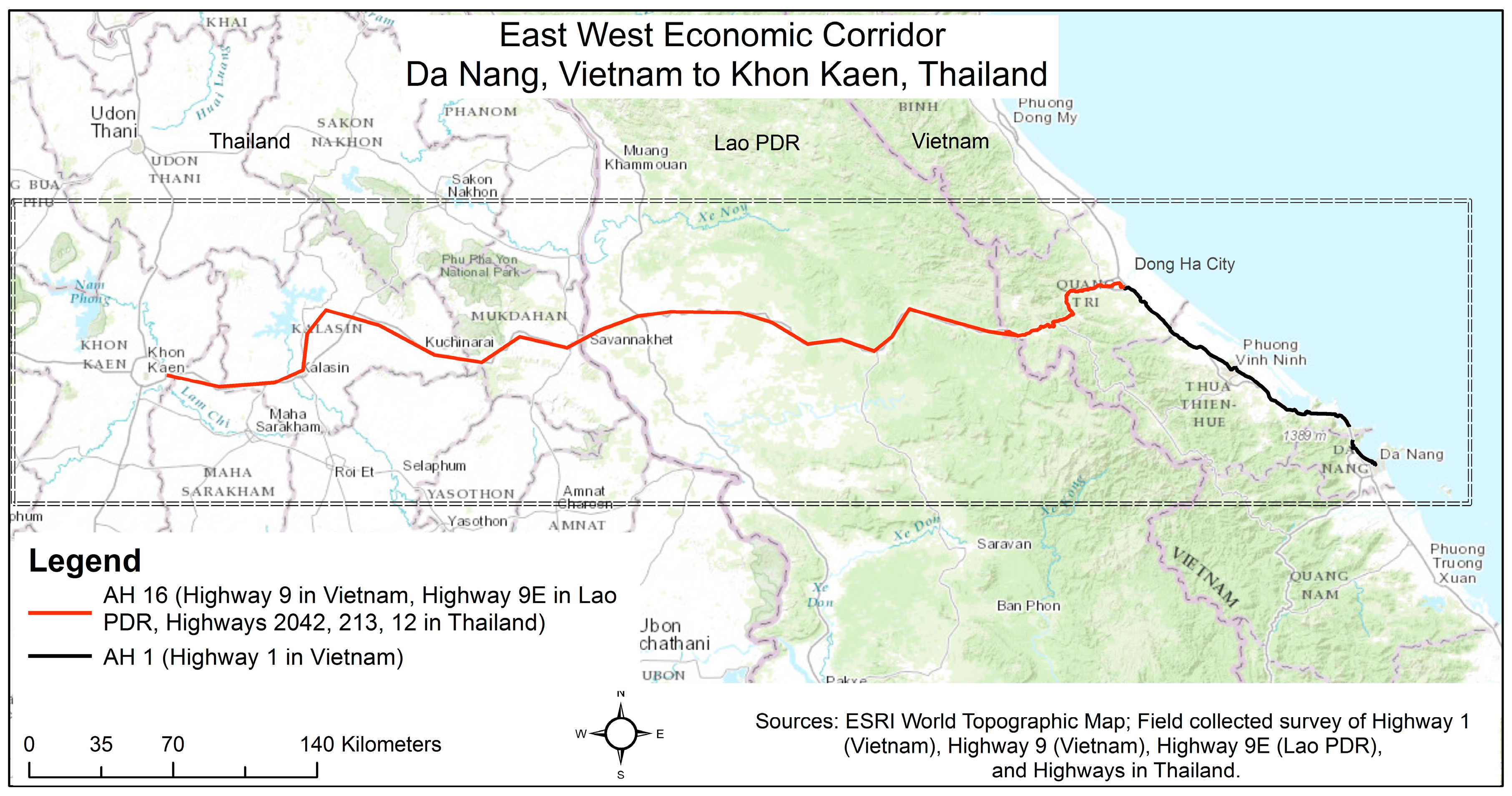
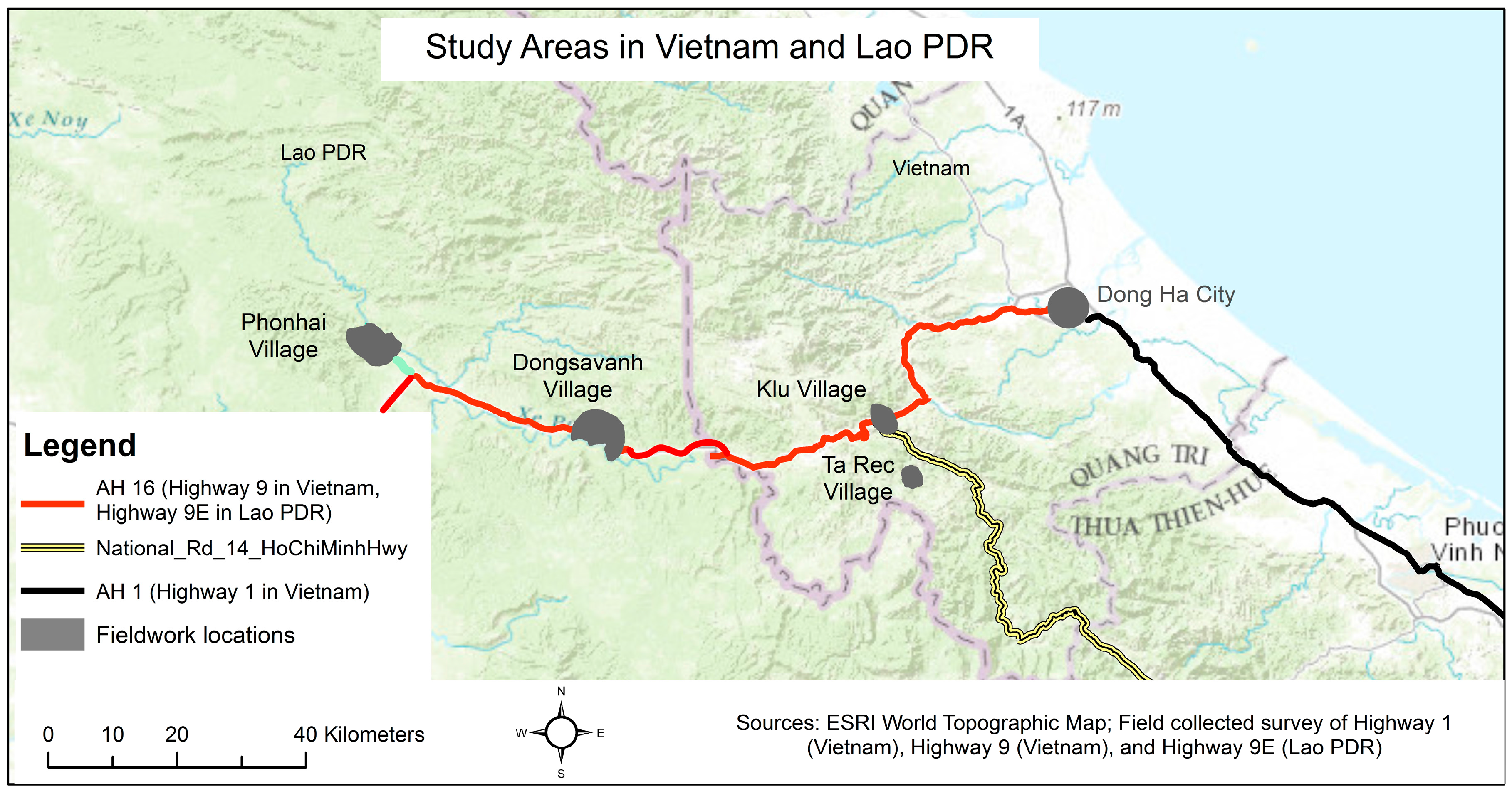
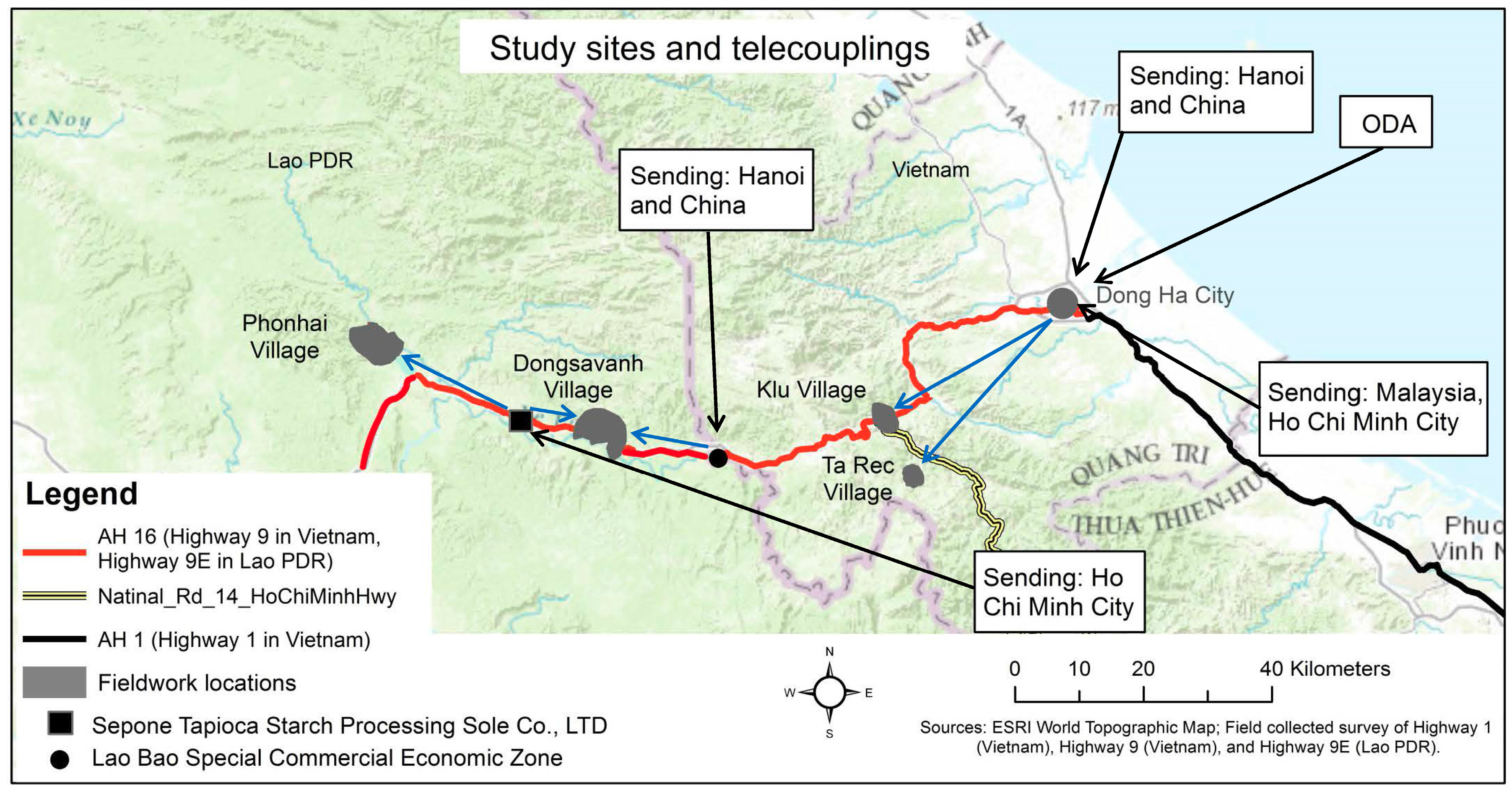
The analytical framework introduced by Geist and Lambin [13,20] that analyzes land change through an examination of proximate and underlying drivers versus more distant and indirect drivers has been at the heart of LUCC research for many years. The framework looks at the causes of LUCC by examining the local drivers and how they are connected to more distant or underlying drivers of change. The drivers are examined in terms of their temporality and distance from where the change takes place as well as their spatial immediacy to the location of LUCC. The framework also holds that while proximate drivers are more immediate in space and time, e.g., agricultural activities, forestry activities, and construction of infrastructure, the distant, or underlying, drivers, which operate from a distance such as government policy, market forces, or technological demands, are the drivers that are often ultimately responsible for the changes that are observed [20].
The concept of teleconnections which was recently introduced to land change studies from atmospheric science builds on this framework [21,22,23,24]. In atmospheric science, teleconnections refer to how climatic variations or weather anomalies in one geographic region impact on other geographic regions that are often at great distances from where the anomaly or variation started [25,26]. The teleconnections framework is used in land change studies to conceptualize the linkage of a local land-use change and the related land-cover change to geographically distant events [22]. Seto et al. [23] discuss teleconnections in terms of flows of people, economic goods and services, between urban and rural areas that drive land-use change in rural areas, in response to urban growth in distant areas. Teleconnections can be over short distances or long distances, and can be comprised of single linkages or multiple linkages between urban and rural areas [27]. Examples of teleconnections that have been studied include the link between rising incomes in urban areas and the protection of certain environmental services in rural areas; the link being the willingness of urban residents to pay for the services [27]; and the linkage between urban markets for beef in Europe and China and deforestation in Amazonia due to the increased soy and cattle production in Brazil that supplies these markets [28].
Similar to the concept of teleconnections is telecoupling. Telecoupling also examines linkages between disparate geographic regions, but adds an analysis of the feedback between the location where LUCC is taking place, the location(s) where the driver(s) originated and the multi-directional flows of goods and services that characterize interactions between land systems [29,30]. Two main proponents of this idea are Eakin et al. [31] and Liu et al. [32]. Both propose analyses that involve five stages, but the stages differ between the two. Eakin et al. [31] outline a process that involves a trigger, direct impact, indirect impact, feedback, and institutional change. In one study, they look at examples of small holder farmers’ responses to fluctuating global coffee markets and their impact on land-use/cover in Vietnam and Mexico ([31,33]). Liu et al.’s [32] five key components of analysis are systems, agents, flows, causes, and effects. Liu et al. discuss how the telecoupled system is influenced by within and across level interactions and how the telecoupled systems can be characterized as sending, receiving or spillover systems [34]. The structured framework proposed by Liu et al. has been applied to analyzing cases of invasive species and transnational land deals [32] and also to the multiple telecoupling processes between the Wolong Nature Reserve and the rest of the world [35]. Baird and Fox [36] apply a telecoupling framework to examine both transnational and intra-country labor telecouplings. They point out that in some cases telecouplings can be rural-to-rural as well as urban-to-rural, and urban-to-urban.

1.3. Study Area

The study area for this research encompasses the EWEC from Dong Ha City in Quang Tri Province, Vietnam, to Sepon District, Savannakhet Province, Lao PDR (Figure 2). Dong Ha City is the capital of Quang Tri Province. It is located at the intersection of Vietnam’s National Highway 1, which runs north–south between Hanoi and Ho Chi Minh City, and Vietnam’s National Highway 9, which originates at the coast, east of Dong Ha City and goes westward into Lao PDR. In Lao PDR, it becomes Highway 9E and continues to Savannakhet City ending at the Mekong River. Dong Ha City became the capital of Quang Tri Province in the 1990s, when the capital of the province was moved there from Quang Tri town. From interviews it is clear that the move was made to take advantage of the major road intersection between National Highway 1 and National Highway 9 at Dong Ha. Klu village and Ta Rec village are both located in Da Krong District, Quang Tri Province, Vietnam, and Dongsavanh village and Phonhai village are located in Sepon District, Savannakhet Province, Lao PDR.
National Highway 9 passes through Klu 40 km west of Dong Ha City and 15 km from the border with Lao PDR (Figure 2). The population of the village when this study was done was 617 people living in 134 households. Of these, 131 households belong to the Van Kieu ethnic group, and three households are of the majority Kinh (Viet) ethnicity. Before the EWEC was implemented the livelihood system in Klu was based on semi-subsistence agricultural production, mostly upland rice with various other crops grown in small areas, or on the edge, of the swidden fields, and small and large animal husbandry, e.g., chickens, ducks, pigs, and a few cattle and buffalo were raised. Since the opening of the EWEC and the upgrading of Highway 9 in 2007 the livelihood system has diversified as the village has started to produce agricultural products for the market and some small shops and services have opened within the village near the highway providing employment for villagers.
Ta Rec is located around 5 km from the Ho Chi Minh Highway in Quang Tri Province, and within 10 km of Klu (Figure 2). The village had a population of 440 people, living in 80 households when fieldwork was done. All the people who live in Ta Rec belong to the Van Kieu ethnic group. Before the opening of the EWEC and the construction of the Ho Chi Minh Highway, just east of the village from 2005 to 2007, and the construction of secondary roads between the Ho Chi Minh highway and the village in 2005 and 2006, the village was very isolated and there was no direct road access. The livelihood system in the village was based on subsistence agriculture, mostly swidden rice with a small amount of permanent wet rice grown in flat areas near the river. Chickens, ducks, and pigs, along with a few cows and buffalo were raised. Interviewees reported that no agricultural products were sold to outside markets during this time. Since the village has gained road access the livelihood system has been augmented by the introduction of cash crops.
Lao PDR National Highway 9E passes through Dongsavanh (Figure 2). At the time fieldwork was carried out the population of the village was 1242 people living in 213 households. The villagers are mainly of the Tri and Makong ethnicities (70%) and Phouthay (20%). Ten percent of the villagers are of Lao ethnicity (Lao Lum). The village is located 20 km from the border with Vietnam where it was reestablished following the second Indochina War (the Vietnam War). During the war, the villagers reported that they had been forced by fighting and bombing to live scattered in the hills to the south of the village’s present day location, often digging caves and bunkers by hand to live in. Before the implementation of the EWEC, the villagers’ livelihood system was based on the growing of swidden rice and the cultivation of some minor crops for subsistence purposes, with interviewees reporting that little was sold outside the village. Since the opening of the EWEC, the livelihood system has expanded to include the cultivation of crops specifically for sale outside the village. Some animal husbandry is practiced in the village, but the animals raised are for subsistence.
Phonhai is located 7 km from National Highway 9E and 37 km west of Dongsavanh (Figure 2). When fieldwork was done, the village population was 1811 people living in 299 households. The population is made up of people from the Phouthay ethnic group (40%), Makong and Tri ethnic groups (34%) and Lao (Lao Lum) ethnic group (26%). The village sits at the intersection of two secondary roads, one is oriented north–south and connects the village to National Highway 9E and the other is oriented east–west and interviewees said it is possible to reach Vietnam via this road. Until 2008, with the completion of the EWEC road upgrades in the area, the roads were unpaved, deeply rutted, and filled with holes and low spots. The eastern part of the village was not connected to the main road as the secondary road to Vietnam was cut by the Namkok River, which runs northwest to southeast through the village. In 2008, a bridge over the Namkok River was completed connecting the two parts of the village. In 2008, upgrades of both roads were completed as part of the EWEC project; at the time of this study roads were still unpaved, but they had been graded and widened, making travel over them easier. Before the bridge construction and road upgrades, the livelihood system in the village was based on wet rice and upland swidden rice agriculture, with households raising chickens, ducks, and pigs as well as some cattle.

2. Materials and Methods

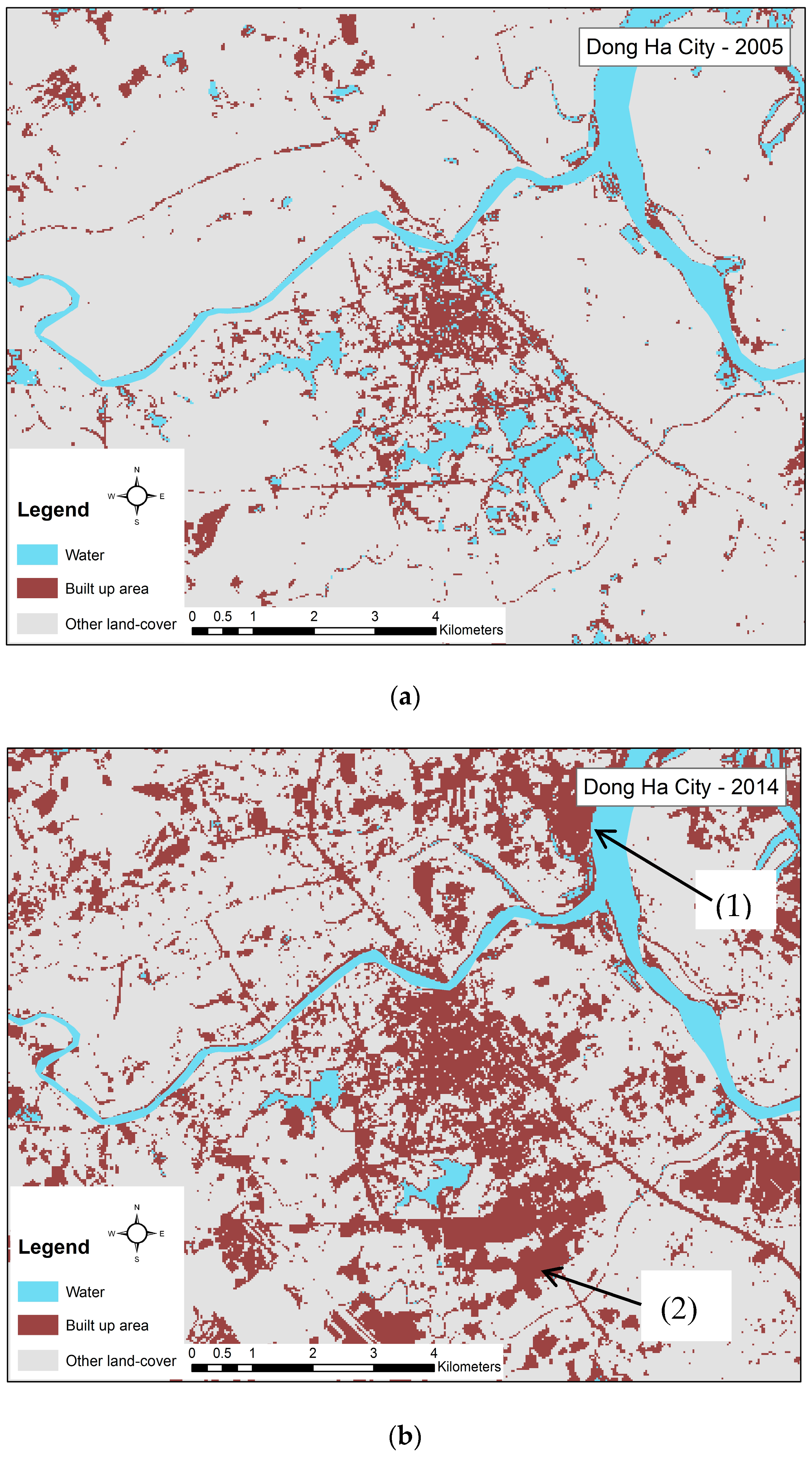
2.1. Urban Change Data Collection in Dong Ha City

In January 2014, a team of researchers from Vietnam National University of Agriculture (VNUA) and Colorado State University (CSU) spent five days in Dong Ha City, Quang Tri Province. During this time, they completed an initial set of interviews with key government policy makers and planners. Semi-structured group interviews were organized with officials from the People’s Committees of each district within the city, as well as the People’s Committee for the City and for the Province. Semi-structured interviews were completed with key personnel from the Department of Planning and Investment (DPI), the Department of Natural Resources and Environment (DONRE), and the Department of Agriculture and Rural Development (DARD) for both Dong Ha City and Quang Tri Province. A series of semi-structured interviews were carried out with key personnel from Quang Tri Province’s Department of Foreign Affairs over a two day period of time. All interviews were conducted in Vietnamese. Interviews focused on economic growth in the city and province over the past 20 years, planning for development in the city and province, historical growth patterns and LUCC in the city over the past 20 years, growth of the economy by sector (agriculture, industry, and services), demographic growth, and foreign investments.
In July 2014, the research team from VNUA and CSU had a one-day follow-up meeting with key personnel from Dong Ha City and Quang Tri Province’s Departments of Planning and Investment and Foreign Affairs as well as representatives of the Province’s and City’s Peoples Committees. The research team presented their initial findings on urban changes that have taken place in Dong Ha City as well as in rural areas of Quang Tri. Findings were discussed with the officials and questions that the researchers and the officials had were discussed. As further questions arose during the analysis of the data, follow-up interviews with the Director of Quang Tri Province’s Department of Foreign Affairs were done via email and telephone between August 2014 and December 2015.

2.2. Village Livelihood System and Land-Use/Cover Data Collection

In July and August of 2014, a multi-disciplinary research team of four men and two women researchers from VNUA and CSU with training in geography, anthropology, soil science, agronomy, agro-climatology and forestry, interviewed government officials at the District and Commune level and spent one week in each village where research took place in Quang Tri Province, Vietnam. In January 2015, a multi-disciplinary research team of three men and two women researchers from Savannakhet University (SKU) and CSU with training in geography, soil science, agronomy, and forestry, spent six days in each village where research took place in Savannakhet Province, Lao PDR. In Vietnam, the team carried out semi-structured interviews with District and Commune DARD and DONRE extension agents, as well as with the Vice-President of the District’s People’s Committee, and the President of the Commune’s People’s Committee. The semi-structured interviews focused on economic, natural resource management and demographic changes at the district and commune levels over the previous 20 years. While the District officials in Savannakhet were visited to obtain permission to do village level research, the SKU research team did not have the time to do in-depth interviews with District officials. The time spent in the villages was limited by the permissions obtained from the village and district level officials.
Qualitative research was carried out in all the villages based on rapid rural appraisal methods similar to those described by Chambers [37], Schoonmaker-Freudenberg [38] and Arnold and Fernandez-Gimenez [39]. Cross-checking and triangulation of all information gathered was done following methods suggested by Chambers [37] and Schoonmaker-Freudenberger [38]. Specific qualitative information gathering methods used in each village were semi-structured interviews, historical interviews, focus group interviews, transect walks, agricultural activity and cropping calendars, and participatory village mapping. The teams were careful to interview men and women, younger members of the village, but not children, as well as older villagers. Interviews were only undertaken after the interviewee had granted permission for the interview to take place. Information collected focused on livelihood activities, including farming practices, demographic information, natural resource management practices, and LUCC information. Historical interviews were carried out with the oldest men and women in each village to gain a qualitative understanding of change over time. Transects were walked in each village to observe actual land-use practices and to collect ground truth points for use in later satellite image interpretation and validation. While walking transects, interviews were carried out with the local guides and opportunistic interviews were carried out with villagers that were met. Four transects were walked per village, each going in a different direction from the village center to the village boundary as recognized by the transect guide. A GPS point was taken at the boundary of the village and the boundary was mapped using the GPS in both directions from that initial point to the extent possible. It is recognized that the boundaries described by the local informants are not official boundaries and it was not possible to validate them with neighboring villages. However, in Vietnam the Government did undertake to survey all village boundaries in the country in the early 2000s [40], but this information has not been published on national maps. All boundary information was cross-checked against the results of the participatory sketch mapping exercise. In each village, a group of villagers participated in a facilitated interview and drew a sketch map of their village. They labeled the different parts of the village, explained the village boundaries, detailed the major land-uses and land-cover of their village area, and explained how land-use and land-cover had changed over time. A minimum of 50 villagers were interviewed in each village. At least 20 of the villagers interviewed were women.

2.3. Satellite Image Interpretation

Landsat TM, ETM+, and OLI surface reflectance high level data [41,42,43] were ordered from United States Geological Survey (USGS) and downloaded for the years 1996, 2002, 2004, 2006, 2007, 2010 and 2014 for the Vietnamese villages and Dong Ha City. Landsat TM, ETM+ and OLI surface reflectance high level data [41,42,43] were downloaded for the years 1994, 1998, 2003, 2008, 2009 and 2014 for the villages in Lao PDR. Surface reflectance high level data products are generated by USGS using specialized software developed by NASA to radiometrically and atmospherically correct Landsat Level-1 data. Once obtained, surface reflectance high level data products can be directly used in calculating vegetation indices without any further corrections [41,42,43]. The selection of available imagery was limited by the presence of cloud cover throughout much of the year and gaps in the data due to satellite errors (Landsat7 ETM+ scan line corrector error). Scenes were downloaded for the months of March–July in order to best identify swidden agriculture fields that are cleared and burned between February and April each year in the villages in Vietnam (from agricultural activity calendars provided by village informants (July 2014)), and February and March each year in the villages in Lao PDR (from agricultural activity calendars provided by village informants (January 2015)) and are identifiable as bare ground on imagery between March and July. The Normalized Burn Ratio (NBR) [44] was selected as one index for this analysis because it has been shown to successfully delineate swidden agriculture areas, especially if images are captured soon after the land is cleared and burned; this is due in large part to the characteristic way short-wave infrared wavelengths interact with bare ground and burned surfaces [44]. The Normalized Difference Vegetation Index (NDVI) was used in conjunction with NBR to further assist in the discrimination between vegetated and non-vegetated land-cover. A stack of the 16 NBR and NDVI products from near cloud-free satellite images (8 dates, 1 NBR and 1 NDVI per date) for the Vietnamese villages and of the 14 NBR and NDVI products from near cloud-free satellite images (7 dates, 1 NBR and 1 NDVI per date) for the villages in Lao PDR corresponding with the aforementioned years were successfully identified and utilized for analysis.
Spatial data, such as shapefiles, for administrative boundaries acquired from the governments of Vietnam and Lao PDR are only available down to the commune level (in Vietnam) and District level in Lao PDR. Village boundaries were thus identified during the participatory data gathering exercises and transects described in the previous section. This information was used in conjunction with 30-m Shuttle Radar Topography Mission data, downloaded from USGS Earth Explorer, to delineate the village study areas before the image interpretation was done. Heads up digitizing in Google Earth was used to create an overlapping vector layer of existing roads and rivers for use in the display of the results.
A binary mask of each study area was created. Using this binary mask to limit the study area, an unsupervised ISODATA classification was carried out in ENVI utilizing the 16 or 14 image NBR/NDVI stack. The input settings for the unsupervised classification were: 50 classes, 2 percent change threshold, and 25 iterations. The resulting unsupervised classification was interpreted using the temporal NBR and NDVI signatures of each output class to identify year-to-year land-cover change. Interpretations were supplemented by ground truth data collected during fieldwork, Google Earth historical imagery, and visual interpretation of true color Landsat images. Classes that included swidden agriculture fields (i.e., cleared and burned areas) were the primary focus for this interpretation, but other land-cover changes linked with infrastructure expansion were also detected. The other changes are not reported here as they are not the focus of the article. The cleared field (active swidden agriculture) versus fallow/secondary forest land-cover accuracy was assessed using the participatory mapping results, interviews carried out during the transect walks, and ground truth points/pictures obtained using global positioning system (GPS) receivers and cameras (reported accuracy ± 10 m).
Urban area change analysis was done using the TM, ETM+ and OLI images for Vietnam. Thresholding of the NDVI output for each year of imagery analyzed was done to separate areas where new building had taken place in and around Dong Ha City. The output was ground truthed by referring to the interview data from city officials who described when building took place in each part of the city; visual analysis of high resolution imagery displayed in Google Earth for corresponding years; and visual interpretation of true color Landsat images. The initial output was presented to city officials during the follow-up meeting in July 2014 and revised according to their critique.

2.4. Analysis of Upland Agricultural Field Placement

The output of the previously described image analysis was converted to ESRI shapefiles. Upland areas cleared for agriculture were extracted as a separate class and corresponding area statistics were calculated for each year. In order to analyze if field placement near roads increased by year, a buffer was created around the roads in the villages and the total amount of upland agriculture fields within the buffer were compared by year over the time-series. The change in the percent of the total upland agriculture fields in the village that were within the buffered area for each year was also compared. The buffer for each village corresponds to the distance from the road to the nearest mountain top, hill top, or ridge top. These topographic features were used to limit the buffers since villagers explained that it is easiest to transport heavy and bulky crops like cassava to the road if they are grown on sloping land near the road, and ease of transport is necessary in order for villagers to grow crops like cassava. The buffer analysis facilitated the determination of whether field clearing near roads had increased or decreased over the study period. For Klu the buffer is 600 m, for Ta Rec it is 350 m, and for Dongsavanh, and Phonhai villages the buffer is held at 600 m.

3. Results

3.1. Growth of Dong Ha City

Analysis of the Landsat data in conjunction with the interview data identify the way that Dong Ha City’s open areas are being built up as well as the geographical direction the change is following in areas where urban growth is extending beyond the previously built up areas. The interviews with Dong Ha City and Quang Tri Province officials provided details regarding the growth that has taken place; specifically, the creation of Quang Ngang Industrial Park to the northeast of the city and of Dong Ha South Industrial Park just to the south of the city in 2009, and the types of factories that have been built in these zones, including textile, wood processing, specifically medium density fiberboard (MDF) processing, and cassava processing factories. The interviewees also explained that investment in the two industrial zones originates from China, Malaysia, and Hanoi and Ho Chi Minh City from within Vietnam. Along with the development of the two industrial zones, previously open areas near the center of Dong Ha City have been filled with new buildings, both residential and commercial. New urban residential growth is extending from the city center to the south, following major roads. In places this led to the filling in of water bodies. Figure 3a,b illustrates details of this growth by comparing the area of Dong Ha City before the EWEC was completed and after its completion.
City and province officials identify three drivers of urban growth in Dong Ha City: the industrial parks and domestic and foreign investment in new industries, growth of government departments, and the real estate market. These three drivers are also evident in other instances of urban expansion and LUCC in urban areas in Asia [45,46,47,48] and worldwide [49].
Domestic and foreign investments in agro-industries in the new industrial parks are responsible for the growth of the city in these areas. Factories that have been built in the industrial zones include a cassava starch processing plant, the Thi Ong Joint Stock Company, and a MDF wood processing plant, Geruco Quang Tri MDF Wood Factory. Investment in these industries is from domestic sources, but in response to foreign and domestic demand. The cassava starch produced is sent to Hanoi and Ho Chi Minh City where it is used in the food processing and animal feed industry and to China where it is also used in food processing. MDF wood processed in Dong Ha City is used by manufacturers in Hanoi and Ho Chi Minh City. The wood used in the MDF factories is softwood, such as acacia, and is reported to come from upland areas of Quang Tri province, such as the two villages where research was done for this study. The MDF products are also exported to Malaysia.
The Government of Vietnam (GOV) has expanded government services in Quang Tri Province, directly leading to an increase of government employees in Dong Ha City. This has led to growth both in the physical infrastructure of the city (buildings, roads, etc.) and to demand for more residential buildings to house the increase in personnel and their families. The real estate market in Dong Ha City is jointly guided by both the government and private sectors. The government clears the land, rezones it to urban, and sells it into the private market in order to derive funds for local government use; the private companies who buy the land then develop and resell it. This driver is hinted at in interviews with government officials and was clearly explained in discussions with a local regional planner and also in informal opportunistic interviews with local residents in Dong Ha City.

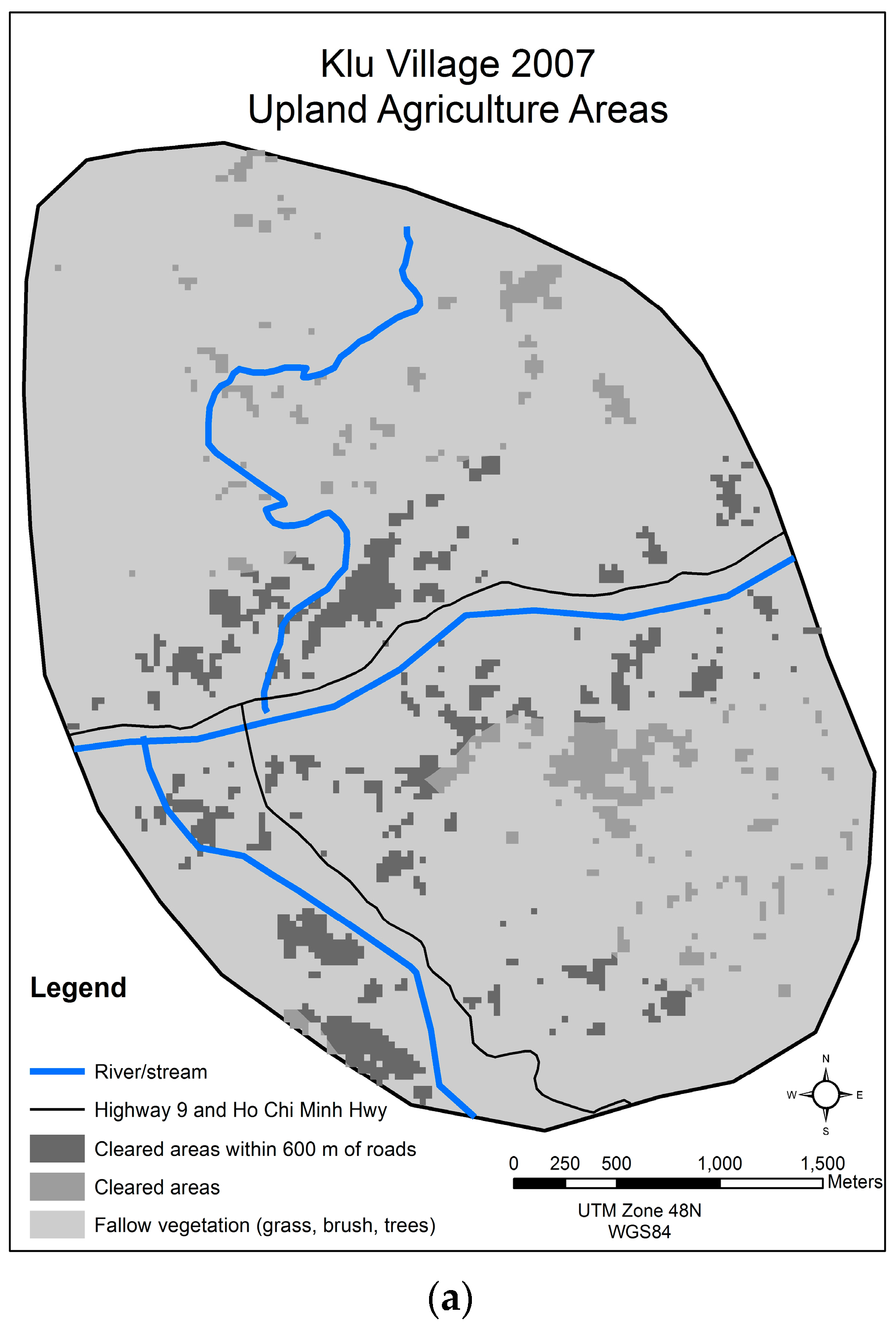
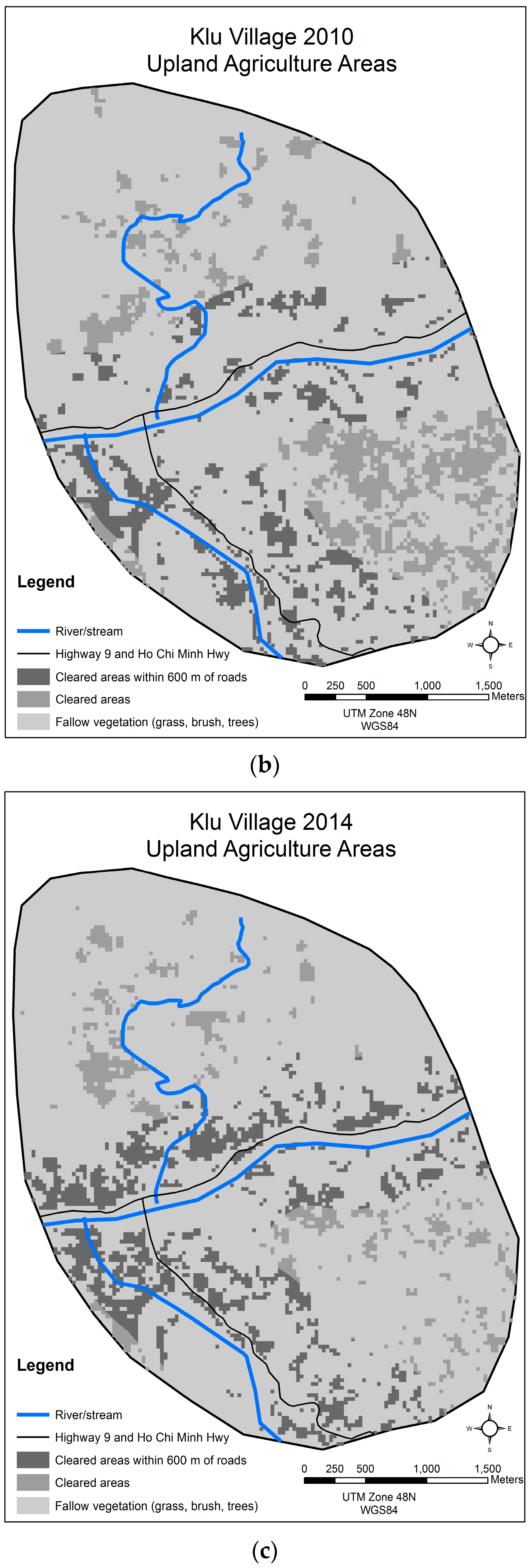
3.2. Klu, Da Krong District, Quang Tri Province

Interviewees discussed Klu’s history and said that Klu has been located near National Highway 9 since 1975. They explained that even though Klu has been located on a main highway, access to markets was not good prior to the EWEC project as the road was barely passable in places, only one-lane and not completely paved. In July 2006, Highway 9 was upgraded and the Ho Chi Minh Highway was completed, intersecting with Highway 9 near the village. With these improvements, road access markedly improved. Multiple villagers recall that in 2010 and 2011 people who they thought were extension workers associated with the cassava processing factory in Dong Ha City visited Klu promoting hybrid cassava for production and promising that the cassava processing factory would buy the harvest. Even though some villagers noted that hybrid cassava was initially grown in the village as early as 2006, all interviewees stated that the villagers only started growing large amounts of hybrid cassava after these visits. Villagers also said that they grew the hybrid cassava near the newly improved Highway 9 after 2010 and that they decreased the cultivation of upland areas farther from the road. Upland areas farther from the road had previously been used to cultivate upland rice. Observations from transects the research team walked corroborate that this is still the case. The interview data corroborates the image analysis and area statistics shown in Figure 4a–c and Table 1.
Shortly after Highway 9 was upgraded as part of the EWEC project, district forestry agents promoted the planting of acacia trees in Klu. This promotion of acacia trees accords with what DARD, DONRE, and DPI officials at both the province level and district level explained are national re-greening policies. A DPI official also explained that acacia is the main softwood variety used in MDF processing. Interviewed villagers explained how they have integrated acacia trees into their fallow rotation and plant them on previously cultivated upland areas farther from the village and road. Areas of four to six year old acacia were observed on transect walks and some villagers said they are preparing to harvest and sell their trees. From interview data, complemented by our observations, it is clear that the introduction of hybrid cassava and acacia in the village are the main proximate drivers of the changes in the village’s landscape patterns that is shown in the image analysis results, e.g., the clustering of upland agriculture fields near the newly renovated Highway 9 and the decrease in the use of upland fields more distant from the roads. The interview data also indicate that it is possible that there is an increase of tree cover in areas further from the road, and the image analysis shows this taking place between 2010 and 2014.

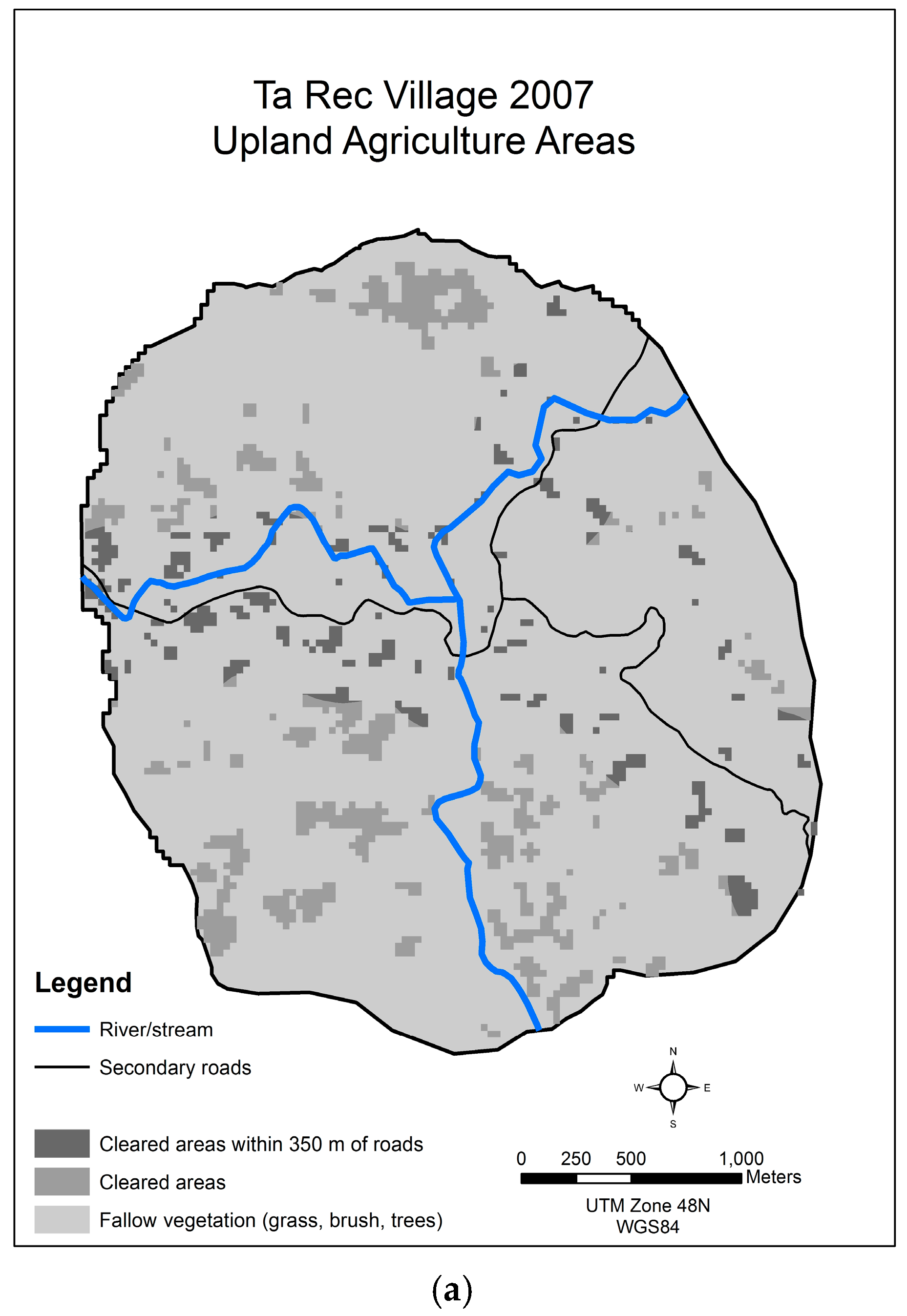
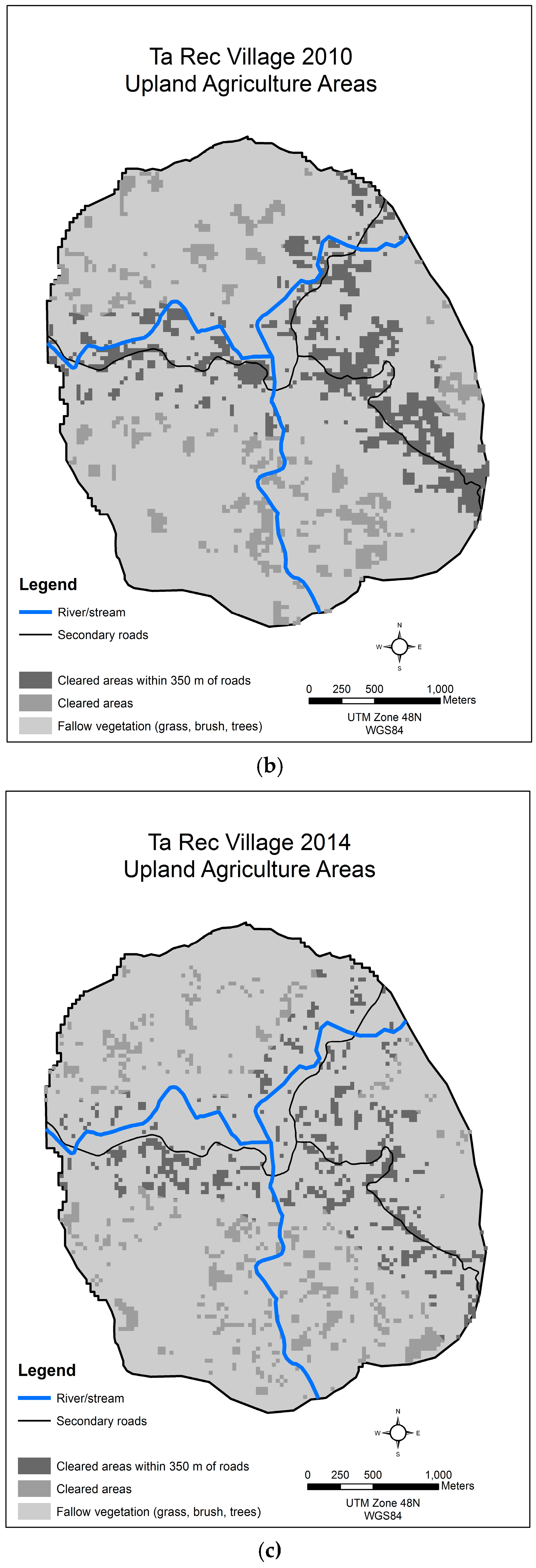
3.3. Ta Rec, Da Krong District, Quang Tri Province

Villagers interviewed recalled that livelihood systems started to change in Ta Rec in 2005 and 2006 with the completion of a secondary road linking their village to the Ho Chi Minh Highway, which was then nearing completion. At this time, a few new shops opened in the village, a health clinic was opened, and villagers started to travel out of the village more frequently. Interviewees said that they learned that they could grow maize and cassava to sell in the market and that there was a demand for acacia trees. Interviewees also reported that some villagers started to cultivate these crops in their swidden fields and to integrate acacia trees into their fields. Land-use and cover has continued to change since then. Villagers consistently said that in 2009 and 2010 middlemen came to the village and informed villagers that if they grew hybrid cassava the middlemen would return and buy the crop. Since then, the villagers reported that the middlemen have been coming on a yearly basis and buying the hybrid cassava that they produce. Interviewees also said, and our observation confirmed, that the graded and paved secondary road network continued to expand in the village as the government extended the network to go to military posts on the border with Lao PDR. The most recent road in the village was completed in 2010. Interviewees explained that the village expanded fields on which to plant cassava near the newly constructed secondary roads in the village because it is difficult to carry the heavy and bulky cassava roots from distant fields to the roadside where middlemen are willing to come to collect the crop. Villagers said that they have continued to grow rice, jackfruit trees, mango trees, banana and some maize in swidden fields farther from the road. Overall villagers said that cultivated fields at first expanded in the village in 2010 in response to their expanding the number fields on which to grow hybrid cassava, then their swidden field area decreased as it was hard for families to keep that many dispersed fields cultivated. Figure 5a–c shows the distribution of areas cleared for agriculture on a yearly basis. Table 2 shows the area of upland crops on a yearly basis and the area of fields near the roads and further from them.
The results of the image analysis and the results in Table 2 illustrate what the villagers of Ta Rec explained. Prior to 2007, upland fields were scattered throughout the village. In 2010, there was a clustering of fields near the two new secondary roads, while a similar amount of upland fields were still scattered throughout more distant areas of the village. In 2014, there was a decrease in the number and area of upland fields compared to 2010, but not compared to years previous to that. However, there was still a clustering of a large number of these fields (43 of 90 hectares or 48% of all the fields) near the secondary roads. As noted by the villagers, a field near the road is the preferred location for growing hybrid cassava. The villagers explained that while they had known of hybrid cassava before 2009, the expansion of the growing of hybrid cassava that followed improved road access to the village and the arrival of middlemen, and they indicated that these two events were the drivers of changes in their land-use.

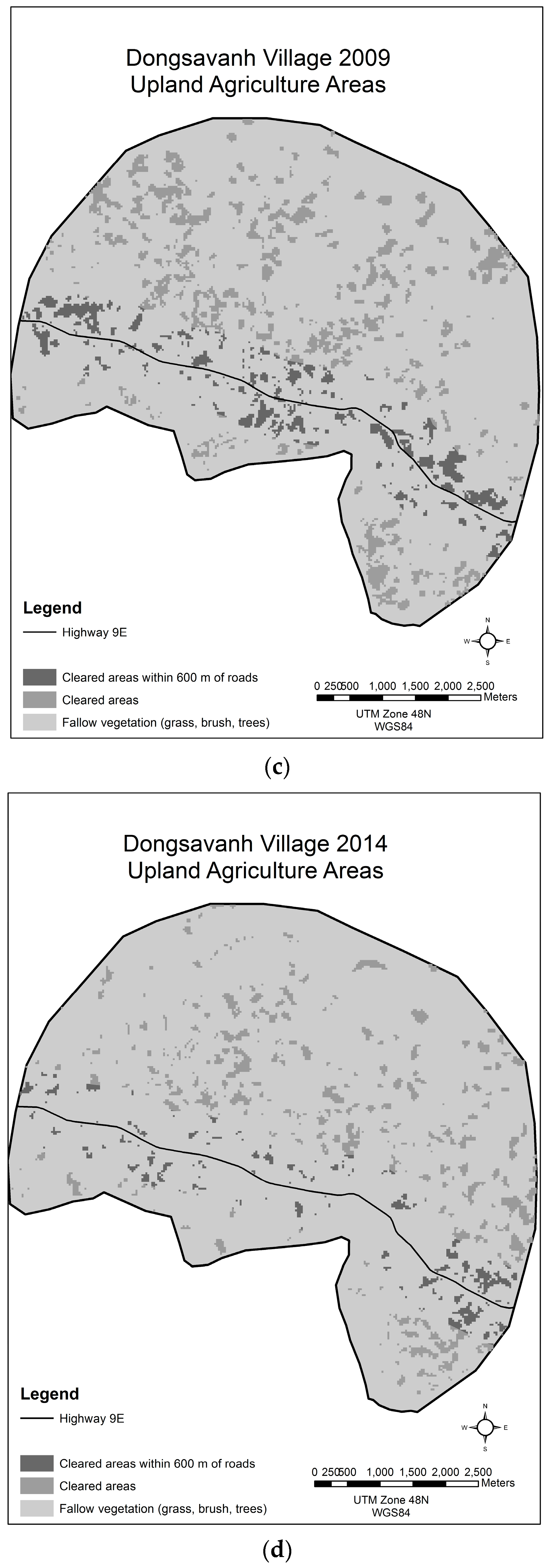
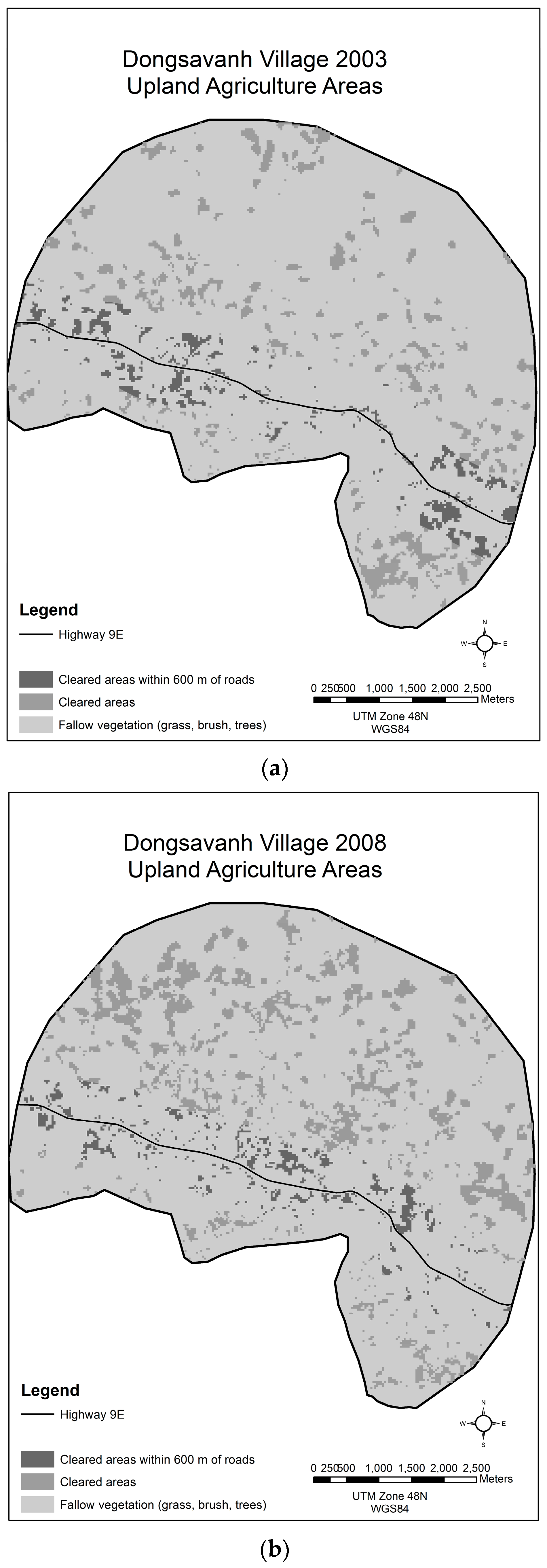
3.4. Dongsavanh, Sepon District, Savannakhet Province

Villagers in Dongsavanh explained that until the implementation of the EWEC and the upgrading of Highway 9E in 2007, the road through their village was little more than an unpaved track. In 2007, as part of the EWEC project the road was paved, widened, and generally upgraded, and border crossing protocols were simplified at the Dansavan-Lao Bao border post 20 km away [3]. Changes in the border crossing regulations are still being phased in [1,3] and interviewees in Dongsavanh say it is much easier to cross the border at the official border post today than it was prior to the EWEC project. Villagers interviewed also explain that since 2007 the livelihood system of Dongsavanh has changed. Villagers said that they heard about the demand for hybrid cassava from the cassava processing factory in Dong Ha City, Quang Tri, Vietnam and for bananas from the food processing factories in Lao Bao Special Commercial Economic Zone (LBZ) in Vietnam from middlemen who travel back and forth across the border on a daily basis. Interviewees explained that because of this information they expanded planting hybrid cassava and bananas in their fields. Observations by the research team confirm that these two crops have been integrated into the local farming system and land-cover in the area has correspondingly changed.
This finding is similar to reports of other cross-border information flows promoting the adoption of new or novel types of crops for sale to middlemen in Lao PDR. Zeigler et al. [50] and Friis et al. [51] discuss how rubber was promoted in Northern Lao PDR via cross-border information flows from China and Friis et al. [52] document how banana has more recently been promoted in Northern Lao PDR. One difference between the observed cross-border adoption of cassava and banana in Dongsavanh and the adoption of rubber and banana in northern Lao PDR is that in Northern Lao PDR the local inhabitants lost control of their land to migrants from other places who gained rights to land in order to grow the promoted crops [51,52,53], while in Dongsavanh the villagers explained that they have retained control of their land and plant the new crops themselves for sale to middlemen. In 2009, a new cassava starch processing factory, the Sepone Tapioca Starch Processing Sole Co., LTD, was built seven kilometers west of Dongsavanh. Interviewees said that after this they no longer sold their cassava to middlemen for transport over the border; rather they now sell cassava directly to the new factory. Table 3 shows the year-to-year changes in the land cleared for upland agriculture fields in the village and Figure 6a–d show the spatial distribution of these fields.
There is an increase in land cleared for agriculture in 2008 and 2009 corresponding with the completion of the improvements to Highway 9E and with the initial changes to the border crossing regulations. Villagers said that this was the period when they expanded hybrid cassava and started to plant bananas on large areas of land. The decrease in cleared upland agriculture fields between 2009 and 2014 correspond with the continuous cultivation of bananas on agricultural land in the village, which was reported in interviews and confirmed by observation. Once banana plants are growing, there is no need to clear the land again. Banana plants are managed so that a replacement plant is nurtured from the many shoots that a plant sends up. Once the main banana stalk has flowered and fruited, it dies, but the replacement is there to grow in its place, so reclearing the land is not needed. The result of this type of land-use is that the land will be classified as covered with vegetation, since it is continuously covered, and not show up as cleared land in an analysis of satellite imagery of the area.

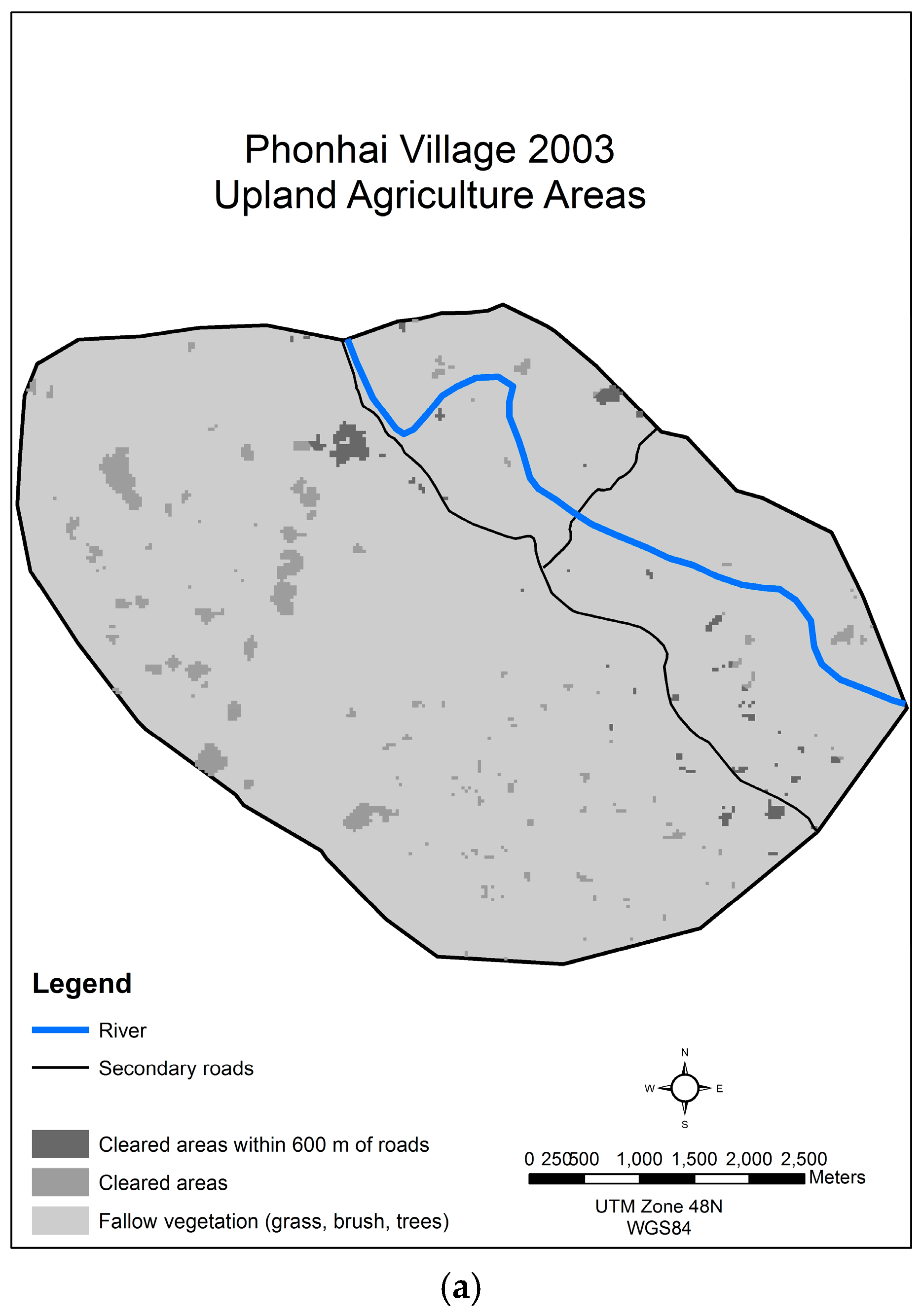
3.5. Phonhai, Sepon District, Savannakhet Province

As described in Section 1.3, improvements to the two secondary roads in Phonhai and the building of a bridge across the Namkok River were completed in 2008 as part of the overall EWEC project. After 2008, the village’s livelihood system changed. Villagers said that they started to produce crops for the market and to sell some cattle to middlemen from Vietnam who started to come to the village each year. However, interviews with villagers make it clear that neither of these changes have been widespread in the village. Beginning in 2013, villagers told us that men associated with Sepone Tapioca Starch Processing Sole Co., LTD on Highway 9E visited the village and promoted the production of hybrid cassava. Farmers had already grown small amounts of this in their fields, but after the first visit, some farmers started to grow this crop east of the river in areas now made easily accessible by the bridge. Villagers report that 30 hectares are now devoted to growing hybrid cassava for sale. The villagers also explained that soon after the construction of the bridge, traders began to visit the village on a yearly basis using the secondary road that connects them to Vietnam. These traders offered to buy their cattle. The villagers said that initially they only sold one or two head of cattle at a time. In 2014, the village is reported to have sold five cattle to the traders from Vietnam. The village leader believes that these cattle are taken to Vietnam. Table 4 shows the amount of area cleared yearly for upland agriculture as well as the area of these fields which are within 600 m of the two roads that pass through the village. Figure 7a–d illustrate the spatial distribution of these fields for the four most recent years in the time-series.
While there was more land cleared for upland agriculture in 2008, 2009 and 2014 than in 2003, the cleared upland agriculture area is smaller than in 1998. This corroborates interviews with villagers who say that while there is some change to the livelihood system, the changes are small. Small numbers of cattle are now being sold to Vietnamese traders, and some farmers are starting to grow cassava. The remote sensing land-cover analysis corresponds to the information gathered through the interviews; there is no overall increase in land cleared for agriculture even though in 2009, after the eastern part of the village was connected to the main village via a bridge, there was an increase in land-used for upland agriculture in that section of the village.

3.6. Validation

The classification of urban growth was qualitatively validated against the descriptions of growth and other information provided by city and province officials during the follow-up meetings in July 2014. In general, the patterns and expansion of growth in and around the cities that is documented in the land-cover assessments in this study mirror that described by the informants. Village land-use/cover patterns and changes were validated qualitatively against village interview data including interviews that took place during participatory mapping exercises and in the field against GPS location data and the interviews done with farmers regarding LUCC at those specific locations. To quantitatively validate the results, 50 random points per village were generated and compared to the land-cover found on high resolution historical imagery from Google Earth for years that coincide with the study’s Landsat data. Where this imagery is available, an agreement of at least 90% was found between the study’s categories of ‘cleared’ and ‘not-cleared’ land and the visual interpretation of those categories on the high-resolution imagery. Other studies [54,55,56,57] have used similar assessment methods to investigate accuracies in classifying forest clearings using Landsat data. Similar levels of accuracy in classifying cleared upland areas in Southeast Asia by using NDVI alone or in combination with other vegetation indices to separate land cleared for swidden agriculture from land covered with different types of vegetation have also been found [54].

4. Discussion: The Multiple Telecoupled Systems within the EWEC in Quang Tri Province, Vietnam, and Sepon District, Savannakhet Province, Lao PDR

This study identifies multiple telecoupled systems at different scales within the study area. The situation within the EWEC lends itself to an analysis of the interconnected telecouplings similar to Liu et al.’s analysis of the multiple telecouplings of the Wolong Nature Reserve [35]. This discussion focuses on the telecoupling processes, the receiving, sending, and spillover systems, that are identified within the study area and the interrelationships between them (Figure 8). Along with identifying these systems, the agents, flows, causes and effects of each telecoupled system are discussed.

4.1. Dong Ha City

The Dong Ha City urban area has experienced growth since it was designated the capitol of Quang Tri Province. As a receiving system in the study area, there are three sending systems that drive its growth. The first of these sending systems is the GOV. The GOV’s policies are responsible for Dong Ha City becoming the capitol of the province, but more importantly, the GOV’s policies are responsible for the changes in the economy which have led to increased foreign investment in Dong Ha City. International and domestic financial systems are the second sending system. Finance from China and Malaysia, and from Hanoi and Ho Chi Minh City, are the main investors in the two industrial parks in the city. Overseas Development Aid (ODA) is the third sending system. Along with the previous two sending systems, the ADB and JICA’s policies on and investment in the EWEC are guiding the building and upgrading of infrastructure in Dong Ha City’s urban area. Spillover systems related to Dong Ha City are evident in the rural areas of the EWEC. These spillover systems are the villages both in Vietnam and Lao PDR where the agents from the industrial parks, or who are associated with them, have promoted growing hybrid cassava and acacia for purchase and use by factories in the industrial parks.
The agents of the sending systems are the international and domestic investors who provide the funding for the factories found in the two industrial parks. The receiving system agents are the factory owners, managers and workers within the industrial parks. The governmental officials within Dong Ha City are receiving system agents; they implement economic and development policies that are decided upon at the central government level. The extension agents and middlemen, whether originating from the industrial park factories or the government extension services, are agents of the receiving system who travel to rural areas and interact with the spillover system agents, the farmers who have adopted the new crops promoted by the factory and extension services.
The main flows of this telecoupling are the GOV policies transmitted from Hanoi; the external financial investments into the industrial parks and the city; and the information flows from the industrial park and Dong Ha City into the rural areas of the EWEC. The causes of these flows can be traced back to the Doi Moi (directly translated as renovation or reconstruction) reforms and policies that were initiated in Vietnam after 1986. The Doi Moi policies encouraged the opening up of the country to foreign investment and the integration of the country into the world market system [58,59,60]. Without these initial changes, the policies that guided the changes in Dong Ha City and the EWEC would not have been initiated and the financial flows into the EWEC in Vietnam would not have happened. The effects of the flows so far in Dong Ha City are the development of the two industrial parks and the urban growth and urban area LUCC that are documented in Section 3.1, as well as the spillover effects that have led to LUCC in rural areas of the EWEC.

4.2. Lao Bao Special Commercial Economic Zone System

Lao Bao Special Commercial Economic Zone (LBZ) is the receiving system on the border between Vietnam and Lao PDR. It was created by the GOV as part of the development of the EWEC [3]. The sending systems to the LBZ are the GOV, international and domestic financial systems, and ODA. The GOV policies guided the creation of the LBZ and continue to support it [61,62,63]; domestic financial systems invested in the industries that have been opened within the LBZ, but the exports from the LBZ respond to demand from Hanoi, Ho Chi Minh City, and China [61]; and ODA policies and money guided the development of the infrastructure within the EWEC and the cross border transport agreements (CBTA) have simplified border crossing policies at the Lao Bao border gate [63]. Spillover systems are rural areas on both sides of the border where new crops have been introduced to provide raw materials for the food processing factories in the LBZ [64].
The agents involved in the sending systems are the GOV policymakers who continue to guide the development of the LBZ [61,63] and domestic investors who provide funding for the factories that are found in the LBZ. The receiving system agents are the factory owners, managers and workers within the LBZ. Extension agents and middlemen, originating from the LBZ’s factories and the government are agents of the receiving system who travel to rural areas and interact with the spillover system agents, the farmers, who have adopted the new crops. Middlemen who are based in the LBZ are agents who cross the border and promote new crops to the spillover systems in Lao PDR. The flows of this telecoupling are the GOV policies that originate from Hanoi; the financial investments into the LBZ; and the information flows from the LBZ into the rural areas of the EWEC on both sides of the border. As described in the Dong Ha City telecoupled system, the ultimate cause of these flows is traced back to the Doi Moi policies of Vietnam that were initiated in 1986. However, the cause of the immediate flows are the initial policies that led to the development of the EWEC, specifically the decisions made to implement more efficient border crossing protocols through the development of CBTAs and upgrade the infrastructure at the border. The effect of the policies has been the development of the LBZ, increased cross-border flows of information and goods, and LUCC in the spillover systems found in both Vietnam and Lao PDR.

4.3. Sepone Tapioca Starch Processing Sole Co., LTD

The Sepone Tapioca Starch Processing Sole Co., LTD, located 20 kilometers west of the Lao PDR-Vietnam border in Savannakhet Province, is the receiving system. The sending system associated with this is finance from Ho Chi Minh City, where the investment for the factory originated. The spillover systems are the villages near the processing factory where the hybrid cassava that the factory processes is grown. The sending system agents are the NTD Starch Company who financed the construction of the receiving system. Investment, information, and people flow between the sending, receiving, and spillover systems. Investments flowed from Ho Chi Minh City to the receiving system to construct the factory. Flows of workers to the factory come from Vietnam, and flows of information from the factory to the local villages promote the growing of hybrid cassava to supply the processing factory. Besides the Doi Moi policies noted above, the initial cause of the flows between the systems were the multi-government policies that led to the creation of the EWEC and allowed for the cross-border financial flows that built the tapioca processing factory and for workers from Vietnam to enter Lao PDR to staff the factory. The immediate cause is the ODA policy of the ADB and JICA that provided financial assistance for upgrading the EWEC infrastructure and the CBTAs. The first of these led to easy transport of cassava between rural villages and the tapioca processing factory; the second facilitated export of products out of Lao PDR to other countries along the EWEC. The effect of this telecoupled system and its spillover systems has been a change in the rural livelihoods and LUCC in the border area of Savannakhet Province.

4.4. Rural Village Spillover Systems

When starting from the scale of urban and industrial areas and analyzing the telecouplings within the EWEC in Quang Tri, Vietnam, and Sepon District, Savannakhet, Lao PDR, the rural villages are categorized as spillover systems, as they fit the description of spillover systems defined by Liu et al. [32,34,35]. However, if the purpose of the study goes beyond the understanding of the higher level telecoupling processes, and includes a focus on rural LUCC that is taking place, then a reorientation of the analytical starting point for the telecoupling analysis needs to take place. This need to potentially analyze telecouplings at different scales and from different starting points is pointed out by Friis et al. [30] when they note that “[t] he categorization of systems depend to a large extent on the analytical entry point, the scale of analysis and the defined flow of interest in the analysis” [30] (p. 138). In order to understand the drivers of LUCC at the village level, the four case studies for which results are presented in Section 3.2, Section 3.3, Section 3.4 and Section 3.5 are examined from the starting point of these cases being receiving systems. This change of scale and starting point is needed to provide insight into how LUCC is taking place within the EWEC in rural areas; analysis that may be hidden if the focus is only on the higher level telecoupled systems in the broader EWEC context.
When considering Klu and Ta Rec as two separate receiving systems, the sending system for both is Dong Ha City with its two industrial parks where hybrid cassava is processed and MDF is produced. The way the sending system operates is described in more detail as the receiving system–spillover system interactions in Section 4.1. In the cases of Klu and Ta Rec as receiving systems, the spillover systems are other rural areas that produce similar products for the factories and locations worldwide where the products made by these factories are purchased. The agents are the farmers who have adopted growing hybrid cassava on their fields and integrated acacia into their fallow lands. Other agents include the traders who transport the products to the factories. The spillover system agents are those who ultimately consume these products and farmers in locations distant from these villages who are now affected by changing market prices due to the production of hybrid cassava and acacia by the farmers of Klu and Ta Rec.
The main flows between the sending, receiving, and spillover systems are the initial information brought from Dong Ha City’s industrial parks to the villages; the flow of cassava and acacia from the villages to the two industrial parks’ factories; and the flow of products to domestic and international locations for sale to consumers. Other flows can also be identified, such as flows of money via the middlemen to the farmers of the villages; flows of consumer goods from the urban areas of Vietnam, some of which come via the markets of Dong Ha City, to the villages; and flows of processed foods from the LBZ via local traders which villagers in both Klu and Ta Rec described. The causes of the telecoupling of these two villages can be traced back to the Doi Moi policies of Vietnam described in Section 4.1. However, the immediate causes of these villages becoming local receiving systems are the upgrading of the EWEC road infrastructure and the building of new paved roads as part of this project. Respondents in both villages explained that hybrid cassava was already grown in small amounts in their villages before the road upgrades, and that they knew about acacia trees before 2010. However, it was the flow of information from the industrial parks in Dong Ha City that middlemen brought to the villages after the EWEC road upgrades that are credited by the villagers as the reason that they expanded growing hybrid cassava in upland agriculture fields and expanded the planting of acacia in their fallow fields. The effects of these two changes are reported in Section 3.2 and Section 3.3. The livelihood systems of both villages have become more market oriented and more consumer goods are bought in the villages. The landscape of the villages has also changed as upland agriculture fields are now placed closer to roads, and less land is cleared for agriculture further from roads. There is evidence in the remote sensing analysis that this change in how upland agriculture is practiced is leading to longer fallows further from the roads. With villagers explaining that they are planting more acacia in fields distant from roads, this could lead to a feedback response as more trees are grown in areas of both villages which are farther from roads. However, at this point in time, this feedback is conjecture since the changes documented have only taken place in the past six years or less.
The village systems on the Lao PDR side of the border can also be analyzed as receiving systems. When considering Dongsavanh as a receiving system, the two systems of the LBZ and the Sepone Tapioca Starch Processing Sole Co., LTD, are identified as the sending systems. However, villagers in Dongsavanh said that initially they were influenced to grow hybrid cassava by the cross-border traders from Vietnam, an indication that Dong Ha City’s two industrial parks may have been an earlier sending system. The ways that these three sending systems interact with the receiving system are described in more detail as the receiving system-spillover system interactions in Section 4.1, Section 4.2 and Section 4.3. The spillover systems from Dongsavanh village are other rural areas that produce banana and hybrid cassava for the sending systems and also locations worldwide where the products made by these factories are purchased. The Dongsavanh farmers who have adopted growing hybrid cassava and banana are the agents. Other agents include the traders who transport the products to the LBZ and to the Sepone Tapioca Starch Processing Sole Co., LTD. The spillover systems’ agents include those who ultimately consume the products made from Dongsavanh’s cassava and bananas and farmers in other villages whose products compete with Dongsavanh’s products. These include farmers in Sepon District who grow hybrid cassava for sale to Sepone Tapioca Starch Processing Sole Co., LTD, and farmers who grow bananas in both Sepon District and on the Vietnam side of the border [64].
The main flows between the sending, receiving, and spillover systems are the information brought from the LBZ and the Sepone Tapioca Starch Processing Sole Co., LTD to the village; the flow of cassava from Dongsavanh to the Sepone Tapioca Starch Processing Sole Co., LTD, and bananas to the LBZ; and the flow of products to locations in Vietnam and Lao PDR, and more distant international locations, for sale to consumers. Other flows can also be seen, such as flows of money via the middlemen to villagers in Dongsavanh, flows of consumer goods from the urban areas in the EWEC, including Savannakhet City, Dong Ha City, and locations in Thailand to Dongsavanh, and flows of processed foods from the LBZ and Savannakhet City via local traders which Dongsavanh villagers described. The causes of the telecoupling of this village can be traced back to the original decision by Lao PDR and Vietnam to participate in the EWEC project and to the decisions by ODA providers to fund the project. The immediate causes of Dongsavanh village becoming a receiving system are the upgrading of the EWEC road infrastructure, the CBTA that facilitates the easy and efficient crossing of the border at Lao Bao by traders, and the development of the Sepone Tapioca Starch Processing Sole Co., LTD, by the NTD Starch Company. The effects of the local changes are reported in Section 3.4. The livelihood system is now more market oriented and more consumer goods are bought in the village. The landscape of the village has also changed as cassava fields have replaced rice fields, and permanent fields of banana have been planted in the village replacing large amounts of cleared agriculture fields (Table 3 and Section 3.4).
Phonhai can also be examined as a receiving system. In this case there are two sending systems. The most recent sending system is identified as the Sepone Tapioca Starch Processing Sole Co., LTD. The older sending system is not immediately clear to the villagers, as they only interact with traders from this system, but is understood to be the urban areas of Vietnam where the demand for beef cattle originates. The operation of the Sepone Tapioca Starch Processing Sole Co., LTD sending system in relation to the receiving system is described in more detail as the receiving system–spillover system interaction in Section 4.3. The feedlots near the urban areas of Vietnam operate as a sending system to Phonhai in the following way: first with increased purchasing power, urban beef consumption in Vietnam has increased [65,66,67], second, this demand for beef is reaching distant locations such as Phonhai through traders who act as cattle buyers and then drive the cattle to the feedlots. The spillover systems from Phonhai are other rural areas that produce cassava and cattle for the sending systems, locations worldwide where the cassava products made by the Sepone Tapioca Starch Processing Sole Co., LTD are purchased, and consumers in urban areas of Vietnam who consume the beef. The agents in the Phonhai system are the farmers who have adopted the growing of hybrid cassava on their fields and the villagers who raise cattle. Other agents include the traders who transport the cassava to the Sepone Tapioca Starch Processing Sole Co., LTD, and the middlemen who purchase and drive the cattle from Phonhai to Vietnam. The spillover systems’ agents are those who ultimately consume these products as well as farmers in other villages in Sepon District who grow hybrid cassava for sale to Sepone Tapioca Starch Processing Sole Co., LTD, and villagers in other places who sell cattle to feedlots in Vietnam.
The main flows between the sending, receiving, and spillover systems are the information brought from the Sepone Tapioca Starch Processing Sole Co., LTD to the village; the information about the cattle market in Vietnam brought to the village by cross-border traders; the flow of cassava to the Sepone Tapioca Starch Processing Sole Co., LTD; the flow of cattle to feedlots in Vietnam; and the flow of beef products to urban areas in Vietnam and cassava products to locations in Vietnam, Lao PDR, and other countries. There are other flows to Phonhai such as the flow of money via the middlemen and cattle traders to the villagers in Phonhai, flows of consumer goods from the urban areas in the EWEC, including Savannakhet City, Dong Ha City, and locations in Thailand, to Phonhai, and flows of processed foods to Phonhai via local traders. All of these flows were described by Phonhai villagers. The causes of the telecoupling can be traced back to the decision by Lao PDR and Vietnam to participate in the EWEC project and the decisions by ODA providers to fund the upgrading of secondary roads in Savannakhet Province, so that villages distant from Highway 9E can access the main road and the markets in the corridor. The immediate cause of Phonhai becoming a receiving system, though, is the building of the bridge across the Namkok River and the upgrading of the two secondary roads through the village described in Section 3.5. The bridge provided Vietnamese traders access to the village, and the roads provided middlemen associated with the Sepone Tapioca Starch Processing Sole Co., LTD easy access to the village. The effects of these changes are reported in Section 3.5. The main effect is that the village’s livelihood system is now more market oriented than it previously was and more consumer goods are brought to the village over the improved road. Unlike the other three rural receiving systems looked at in this paper, the remote sensing analysis shows that the landscape of the village has not changed. While villagers are selling a few more cattle than before and raising a few more, the increase has not been large enough to lead to designated pasture areas in the village and the impact of growing hybrid cassava has not led to an increase in agricultural fields or in changes in the locations of agricultural fields.

5. Conclusions

To return to the four questions that guided this research, the following is clear. Four rural cases are examined to determine what LUCC is taking place in rural areas of the EWEC and if the changes are equivalent on both sides of the Lao PDR/Vietnam border. Analysis of both the interview data and the remote sensing data shows that LUCC is taking place in the rural areas on both sides of the border. However, the changes are not equivalent. In the two villages located on the Vietnamese side of the border, villagers said that their land-use has changed, they grow more hybrid cassava and they are planting more acacia in their distant fallow areas. The remote sensing analysis of the most recent years’ images confirms this change in the land-cover, that agricultural fields where cassava is grown have moved closer to roads and the cleared areas further from the road have decreased. In one village in Lao PDR, the villagers report that they have changed their land-use, introducing bananas into their system on a large scale, and also increasing the amount of hybrid cassava that they are growing. The remote sensing analysis shows these changes reflected in the land-cover, with the most recent year’s imagery showing a decrease in cleared fields, which is what is expected given that banana is now a major crop in the village. However, in the second village in Lao PDR, the villagers report that there are few changes in their land-use, and the remote sensing analysis confirms this, showing no real change in land cover.
The drivers of the rural LUCCs are linked to the telecouplings identified between sending systems outside the corridor, urban and industrial locations within the corridor and the rural areas of the corridor. The telecouplings are taking place on multiple levels. At the highest level, there are telecouplings between the urban and industrial locations of the EWEC, including Dong Ha City, the LBZ and the Sepone Tapioca Starch Processing Sole Co., LTD, and external areas that are financing these locations and receiving products from them. At a local level there are telecouplings between the urban and industrial locations and rural villages within the EWEC. These lower level telecouplings are driving the LUCC in the rural areas. However, the evidence from this study and the four cases focused on is that the telecoupling is only accomplished when a route over which flows of information and goods can travel is available. In the cases looked at, here that route was provided by the upgrading of the road infrastructure to the rural villages. All of the villages were introduced to hybrid cassava, and the two villages in Vietnam were introduced to acacia, before the road infrastructure was improved and villagers in each village said that they were aware of the market possibilities of these crops years before they started to widely cultivate them. However, it was only after the telecoupling connection via the improved roads was made that the three villages of Klu, Ta Rec, and Dongsavanh expanded the cultivation of hybrid cassava, acacia, and, in the case of Dongsavanh, banana. The improved connectivity between the sending and receiving systems, facilitated by the road upgrades and construction, led to the telecouplings identified here and ultimately drives the LUCC. Without that improved connectivity, LUCC does not take place.
A final point that should be made is that the rural LUCC found in this part of the EWEC is not unidirectional. While three of the rural receiving systems exhibit LUCC, the land-cover changes are not in a uniform direction. In the case of Klu, there is evidence that the telecoupling driven changes result in more trees on the landscape as swidden areas are left fallow for longer periods of time. Discussions with villagers indicate that this is the case and the most recent remote sensing evidence shows this LUCC is taking place in areas distant from the road. In Ta Rec, the initial LUCC following the introduction of the new roads and the improved connections to sending systems was an increase in the clearing of land for agriculture. However, in the following years, the area cleared for agriculture was reported to decrease and image analysis confirmed this. However, unlike in Klu, the decrease in cleared land between 2010 and 2014 is near the roads. Thus, the signal for Ta Rec is not clear regarding whether LUCC in the village will ultimately lead to more or less agricultural field clearing per year and where that clearing will take place. In Dongsavanh, the signal is complicated by the growing of bananas. As explained in Section 3.4, fields where bananas are grown only need to be cleared once, then the banana can be managed so that the field remains covered with vegetation. In this case, evidence suggests that the long-term trend will be a decrease in tree cover in the area as agriculture land is used for hybrid cassava, bananas and rice growing, but given the banana fields on the landscape, confirming this will be more difficult via the analysis of remotely sensed data than in the cases of Klu and Ta Rec where fields of banana plants are not grown.

Acknowledgments

This research was supported by the National Aeronautics and Space Administration’s (NASA) Land-Cover and Land-Use Change Program (LCLUC) Grant #NNX13AC51G to Colorado State University. We thank NASA’s LCLUC Program for its support. We greatly appreciate the many insightful comments made by the anonymous reviewers. We also wish to acknowledge and thank all of our local collaborators who provided assistance and the villagers who made us welcome during our fieldwork.

Author Contributions

Stephen J. Leisz conceived of and designed the study; Stephen J. Leisz, Eric Rounds, Ngo The An, Nguyen Thi Bich Yen and Tran Nguyen Bang organized and carried out the fieldwork in Vietnam; Ngo The An, Nguyen Thi Bich Yen and Tran Nguyen Bang contributed insights to analysis of Vietnam specific data; Souvanthone Douangphachanh and Bounheuang Ninchaleune organized fieldwork in Lao PDR and contributed insights to analysis of Lao PDR specific data; Stephen J. Leisz and Eric Rounds analyzed the data and wrote the paper.

Conflicts of Interest

The authors declare no conflict of interest.

References

  1. Asian Development Bank. Strategy and Action Plan for the Greater Mekong Subregion East-West Economic Corridor; Asian Development Bank: Manila, Philippines, 2010. [Google Scholar]
  2. Taillard, C. The continental grid of economic corridors in the Greater Mekong Subregion towards transnational ntegration. In Transnational Dynamics in Southeast Asia: The Greater Mekong Subregion and Malacca Straits Economic Corridors; Nathalie, F., Sirivanh, K., Christian, T., Eds.; ISEAS Publishing: Singapore, 2014; pp. 23–52. [Google Scholar]
  3. Pholsena, V. There is more to road: Modernity, memory and economic corridors in Huong Hoa-Sepon Lao-Veitnamese border area. In Transnational Dynamics in Southeast Asia: The Greater Mekong Subregion and Malacca Straits Economic Corridors; Nathalie, F., Sirivanh, K., Christian, T., Eds.; ISEAS Publishing: Singapore, 2014; pp. 379–398. [Google Scholar]
  4. Binswanger, H.P.; Khandker, S.R. How infrastructure and financial institutions affect agricultural output and investment in India. J. Dev. Econ. 1993, 41, 337–366. [Google Scholar] [CrossRef]
  5. Jacoby, H.G. Access to markets and the benefits of rural roads. Econ. J. 2000, 110, 713–737. [Google Scholar] [CrossRef]
  6. Walle, D.V.D. Choosing rural road investments to help reduce poverty. World Dev. 2002, 30, 575–589. [Google Scholar] [CrossRef]
  7. Windle, J.; Cramb, R.A. Remoteness and rural development: Economic impacts of rural roads on upland farmers in Sarawak, Malaysia. Asia Pac. Viewp. 1997, 38, 37–53. [Google Scholar] [CrossRef]
  8. Patarasuk, R.; Binford, M.W. Longitudinal analysis of the road network development and land-cover change in Lop Buri province, Thailand, 1989–2006. Appl. Geogr. 2012, 32, 228–239. [Google Scholar] [CrossRef]
  9. Warr, P. How road improvement reduces poverty: The case of Laos. Agric. Econ. 2008, 39, 269–279. [Google Scholar] [CrossRef]
  10. Warr, P. Roads and poverty in rural Laos: An econometric analysis. Pac. Econ. Rev. 2010, 14, 152–169. [Google Scholar] [CrossRef]
  11. Nishizaki, Y. Suphanburi in the fast lane: Roads, prestige, and domination in provincial Thailand. J. Asian Stud. 2008, 67, 433–467. [Google Scholar] [CrossRef]
  12. Vickerman, R.; Spiekermann, K.; Wegener, M. Accessibility and economic development in Europe. Reg. Stud. 1999, 33, 1–15. [Google Scholar] [CrossRef]
  13. Geist, H.J.; Lambin, E.F. Proximate causes and underlying driving forces of tropical deforestation. Bioscience 2002, 52, 143–150. [Google Scholar] [CrossRef]
  14. Forman, R.T.T.; Alexander, L.E. Roads and their major ecological effects. Annu. Rev. Ecol. Syst. 1998, 29, 207–231. [Google Scholar] [CrossRef]
  15. Alves, D.S.; Pereira, J.L.G.; de Sousa, C.L.; Soares, J.V.; Yamaguchi, F. Characterizing landscape changes in central Rondonia using Landsat TM imagery. Int. J. Remote Sens. 1999, 20, 2877–2882. [Google Scholar] [CrossRef]
  16. Soares-Filho, B.; Alencar, A.; Nepstad, D.; Cerqueira, G.; del Carmen, M.; Diaz, V.; Rivero, S.; Solarzano, L.; Voll, E. Simulating the response of land-cover changes to road paving and governance along a major Amazon highway: The Santarem-Cuiaba corridor. Glob. Chang. Biol. 2004, 10, 745–764. [Google Scholar] [CrossRef]
  17. Stone, T.A.; Brown, I.F.; Woodwell, G.M. Estimation, by remote sensing, of deforestation in central Rondonia, Brazil. For. Ecol. Manag. 1991, 38, 291–304. [Google Scholar] [CrossRef]
  18. Cropper, M.; Puri, J.; Griffiths, C. Predicting the location of deforestation: The role of roads and protected areas in North Thailand. Land Econ. 2001, 77, 172–186. [Google Scholar] [CrossRef]
  19. Chomitz, K.M.; Gray, D.A. Roads, land use, and deforestation: A spatial model applied to Belize. World Bank Econ. Rev. 1996, 10, 487–512. [Google Scholar] [CrossRef]
  20. Geist, H.; McConnell, W.; Lambin, E.E.; Moran, E.; Digenese, A.; Rudel, T. Causes and trajectories of land-use/cover change. In Land-Use and Land-Cover Change, Local Processes and Global Impacts; Global Change—the IGBP Series; Eric, F., Lambin, H.J.G., Eds.; Springer: Berlin, Germany, 2006; pp. 41–70. [Google Scholar]
  21. Adger, W.N.; Eakin, H.; Winkels, A. Nested and teleconnected vulnerabilities to environmental change. Front. Ecol. Environ. 2009, 7, 150–157. [Google Scholar] [CrossRef]
  22. Haberl, H.; Erb, K.; Krausmann, F.; Berecz, S.; Ludwiczek, N.; Martinez-Alier, J.; Musel, A.; Schaffartzik, A. Using embodied HANPP to analyze teleconnections in the global land system: Conceptual considerations. Geogr. Tidsskr. Dan. J. Geogr. 2013, 109, 119–130. [Google Scholar] [CrossRef]
  23. Seto, K.C.; Reenberg, A.; Boone, C.G.; Fragkias, M.; Haase, D.; Langanke, T.; Marcotullio, P.; Munroe, D.K.; Olah, B.; Simon, D. Urban land teleconnections and sustainability. Proc. Natl. Acad. Sci. USA 2012, 109, 7687–7692. [Google Scholar] [CrossRef] [PubMed]
  24. Yu, Y.; Feng, K.; Hubacek, K. Tele-connecting local consumption to global land use. Glob. Environ. Chang. 2013, 23, 1178–1186. [Google Scholar] [CrossRef]
  25. Wallace, J.M.; Gutzler, D.S. Teleconnections in the geopotential height field during the northern hemisphere winter. Mon. Weather Rev. 1981, 109, 784–812. [Google Scholar] [CrossRef]
  26. Steffen, W. The arctic in an earth system context: From brake to accelerator of change. AMBIO 2006, 35, 153–159. [Google Scholar] [CrossRef]
  27. Guneralp, B.; Seto, K.C.; Ramachandran, M. Evidence of urban land teleconnections and impacts on hinterlands. Curr. Opin. Environ. Sustain. 2013, 5, 445–451. [Google Scholar] [CrossRef]
  28. Nepstad, D.C.; Stickler, C.M.; Almeida, O.T. Globalization of the Amazon soy and beef industries: Opportunities for conservation. Conserv. Biol. 2006, 20, 1595–1603. [Google Scholar] [CrossRef] [PubMed]
  29. Friis, C.; Nielsen, J.O. Exploring the Potential of the Telecoupling Framework for Understanding Land Change; THESys Discussion Paper No.1; Integrative Research Institute: Berlin, Germany, 2014. [Google Scholar]
  30. Friis, C.; Nielson, J.O.; Otero, I.; Haberl, H.; Niewohner, J.; Hostert, P. From teleconnection to telecoupling: Taking stock of an emerging framework in land system science. J. Land Use 2016, 11, 131–153. [Google Scholar] [CrossRef]
  31. Eakin, H.; DeFries, R.; Kerr, S.; Lambin, E.F.; Liu, J.; Marcotullio, P.J.; Messerl, P.; Rueda, X.; Swaffield, S.R.; Wicke, B.; et al. Significance of telecoupling for exploration of land-use change. In Rethinking Global Land Use in an Urban Era; Karen, C.S., Anette, R., Eds.; MIT Press: Boston, MA, USA, 2014; pp. 141–161. [Google Scholar]
  32. Liu, J.; Hull, V.; Moran, E.; Nagendra, H.; Swaffield, S.R.; Turner, B.L. Applications of the telecoupling framework to land-change science. In Rethinking Global Land Use in an Urban Era; Karen, C.S., Anette, R., Eds.; MIT Press: Boston, MA, USA, 2014; pp. 119–140. [Google Scholar]
  33. Eakin, H.; Winkels, A.; Jan, S. Nested vulnerability: Exploring cross-scale linkages and vulnerability teleconnections in Mexican and Vietnamese coffee systems. Environ. Sci. Policy 2009, 12, 398–412. [Google Scholar] [CrossRef]
  34. Liu, J.; Hull, V.; Batistella, M.; DeFries, R.; Dietz, T.; Fu, F.; Hertel, T.W.; Izaurralde, C.R.; Lambin, E.F.; Li, S.; et al. Framing sustainability in a telecoupled world. Ecol. Soc. 2013, 18, 26. [Google Scholar] [CrossRef]
  35. Liu, J.; Hull, V.; Luo, J.; Yang, W.; Liu, W.; Vina, A.; Vogt, C.; Xu, Z.; Yang, H.; Zhang, J.; et al. Multiple telecouplings and their complex interrelationships. Ecol. Soc. 2015, 20, 44. [Google Scholar] [CrossRef]
  36. Baird, I.; Fox, J. How land concessions affect places elsewhere: Telecoupling, political ecology, and large-scale plantations in Southern Laos and Northeastern Cambodia. Land 2015, 4, 436–453. [Google Scholar] [CrossRef]
  37. Chambers, R. Rapid rural appraisal: Rationale and repertoire. Public Adm. Dev. 1981, 1, 95–106. [Google Scholar] [CrossRef]
  38. Schoonmaker-Freudenberger, K. Rapid Rural Appraisal (RRA) and Participatory Rural Appraisal (PRA): A Manual for CRS Field Workers and Partners; Catholic Relief Services: Baltimore, MD, USA, 1999. [Google Scholar]
  39. Arnold, J.S.; Fernandez-Gimenez, M.E. Engaging communities through participatory research. In Forest Community Connections: Implications for Research, Management, Governance; Donaghue, E.M., Sturtevant, V.S., Eds.; Resources for the Future: Washington, DC, USA, 2008; pp. 66–87. [Google Scholar]
  40. Leisz, S.J. Reinterpreting the Uplands of Vietnam: Towards Understanding and Correcting a Misreading of Its Land Cover, Land Use, and Resource Management Systems. Ph.D. Thesis, Institute of Geography, University of Copenhagen, Copenhagen, Denmark, 2007. [Google Scholar]
  41. U.S. Geological Survey. Product Guide: Landsat 4–7 Climate Data Record (CDR) Surface Reflectance; Version 6.8.; Department of Interior, U.S. Geological Survey: Washington, DC, USA, 2016.
  42. U.S. Geological Survey. Product Guide: Provisional Landsat 8 Surface Reflectance Code (LaSRC) Product; Version 3.2.; Department of Interior, U.S. Geological Survey: Washington, DC, USA, 2016.
  43. U.S. Geological Survey. Landsat Surface Reflectance High Level Data Products. Available online: http://landsat.usgs.gov/CDR_LSR.php (accessed on 18 September 2016).
  44. Li, P.; Genf, Z.; Jiang, L.; Liao, C.; Zhang, J. A review of swidden agriculture in Southeast Asia. Remote Sens. 2014, 6, 1654–1683. [Google Scholar] [CrossRef]
  45. Byomkesh, T.; Nakagoshi, N.; Dewan, A.M. Urbanization and green space dynamics in Greater Dhaka, Bangladesh. Landsc. Ecol. Eng. 2012, 8, 45–58. [Google Scholar] [CrossRef]
  46. Dewan, A.M.; Yamaguchi, Y. Land use and land cover in Greater Dhaka, Bangladesh: Using remote sensing to promote sustainable urbanization. Appl. Geogr. 2009, 29, 390–401. [Google Scholar] [CrossRef]
  47. Bhatta, B. Analysis of urban growth pattern using remote sensing and GIS: A case study of Kolkata, India. Int. J. Remote Sens. 2009, 30, 4733–4746. [Google Scholar] [CrossRef]
  48. Dewan, A.M.; Yamaguchi, Y.; Rahman, M.Z. Dynamics of land use/cover changes and the analysis of landscape fragmentation in Dhaka Metropolitan, Bangladesh. GeoJ. 2012, 77, 315–330. [Google Scholar] [CrossRef]
  49. Meyfroidt, P.; Lambin, E.F.; Erb, K.; Hertel, T.W. Globalization of land use: Distant drivers of land change and geographic displacement of land use. Curr. Opin. Environ. Sustain. 2013, 5, 438–444. [Google Scholar] [CrossRef]
  50. Ziegler, A.D.; Fox, J.M.; Xu, J. The rubber juggernaut. Science 2009, 324, 1024–1025. [Google Scholar] [CrossRef] [PubMed]
  51. Friis, C.; Reenberg, A.; Heinimann, A.; Schonweger, O. Changing local land systems: Implications of a Chinese rubber plantation in Nambak District, Lao PDR. Singap. J. Trop. Geogr. 2016, 37, 25–42. [Google Scholar] [CrossRef]
  52. Friis, C.; Nielsen, J.O. Small-scale land acquisition, large scale implications: Exploring the case of Chinese banana investments in Northern Laos. Land Use Policy 2016, 57, 117–129. [Google Scholar] [CrossRef]
  53. Fox, J.; Casella, J. Expansion of rubber (Hevea brasiliensis) in Mainland Southeast Asia: What are the prospects for smallholders? J. Peasant Stud. 2013, 40, 155–170. [Google Scholar] [CrossRef]
  54. Leisz, S.J.; Rasmussen, M.S. Mapping fallow lands in Vietnam’s north central mountains using yearly Landsat imagery and a land-cover succession model. Int. J. Remote Sens. 2012, 33, 6281–6303. [Google Scholar] [CrossRef]
  55. Sader, S.A.; Bertran, M.; Wilson, E.H. Satellite change detection of forest harvest patterns on an industrial forest landscape. For. Sci. 2003, 49, 341–353. [Google Scholar]
  56. Wilson, E.H.; Sader, S.A. Detection of forest harvest type using multiple dates of Landsat TM imagery. Remote Sens. Environ. 2002, 80, 385–396. [Google Scholar] [CrossRef]
  57. Cohen, W.B.; Fiorella, M.; Gray, J.; Helmer, E.; Anderson, K. An efficient and accurate method for mapping forest clearcuts in the Pacific Northwest using Landsat imagery. Photogramm. Eng. Remote Sens. 1998, 64, 293–300. [Google Scholar]
  58. Edwards, V.; Phan, A. Managers and Management in Vietnam: 25 Years of Economic Renovation (Doi Moi); Routledge: New York, NY, USA, 2013; p. 130. [Google Scholar]
  59. Fortier, F.; Trang, T.T.T. Agricultural modernization and climate change in Vietnam’s post-socialist transition. Dev. Chang. 2013, 44, 81–99. [Google Scholar] [CrossRef]
  60. Hiep, L. Performance-based legitimacy: The case of the Communist Party of Vietnam and Doi Moi. Contemp. Southeast Asia 2012, 34, 145–172. [Google Scholar] [CrossRef]
  61. Vietnam Trade and Promotion Agency. Economic Zones and Industrial Parks in Quang Tri Province—Part 1. Available online: http://www.vietrade.gov.vn/en/index.php?option=com_content&view=article&id=2020:economic-zones-and-industrial-parks-in-quang-tri-province-part-1&catid=272:investment-opportunities&Itemid=250 (accessed on 21 August 2016).
  62. Japan International Cooperation Agency; ALMEC Corporation. The Research on the Cross-border Transportation Infrastructure: Phase 2 Final Report; Japan International Cooperation Agency: Tokyo, Japan, 2007.
  63. Ishida, M. Special economic zones and economic corridors. In Research on Development Strategies for CLMV Countries; ERIA Research Project Report 2008-5; Kuchiki, A., Uchikawa, S., Eds.; ERIA: Chiba, Japan, 2009; pp. 33–52. [Google Scholar]
  64. Viet Nam News. Switch to Banana Farming Bears Fruit for Commune. 27 October 2013. Available online: http://vietnamnews.vn/sunday/features/246822/switch-to-banana-farming-bears-fruit-for-commune.html (accessed on 28 September 2015).
  65. Thang, N.M.; Popkin, B.M. Patterns of food consumption in Vietnam: Effects on socioeconomic groups during an era of economic growth. Eur. J. Clin. Nutr. 2004, 58, 145–153. [Google Scholar] [CrossRef] [PubMed]
  66. Hop, L.; Mai, L.; Khan, N.C. Trends in food production and food consumption in Vietnam during the period 1980-2000. Malays. J. Nutr. 2003, 9, 1–5. [Google Scholar]
  67. Dung, D.V.; Ba, N.X.; Van, N.H.; Phung, L.; Ngoan, L.; Cuong, V.C.; Yao, W. Practice on improving fattening local cattle production in Vietnam by increasing crude protein level in concentrate and concentrate level. Trop. Anim. Health Prod. 2013, 45, 1619–1626. [Google Scholar] [CrossRef] [PubMed]
Figure 1. The East–West Economic Corridor (EWEC) from Da Nang, Vietnam, to Khon Kaen Thailand. The study area focused on in this paper is included in this section of the EWEC.
Remotesensing 08 01012 g001
Figure 2. Location of the study areas within the EWEC and their proximity to Highway 9 in Vietnam and Highway 9E in Lao PDR.
Remotesensing 08 01012 g002
Figure 3. (a) Extent of Dong Ha City built up area prior to the completion of the EWEC; (b) Extent of Dong Ha City built up area after the completion of the EWEC and construction of two industrial zones in the greater urban area: (1) Quang Ngang Industrial Park, (2) Dong Ha South Industrial Park.
Remotesensing 08 01012 g003
Figure 4. (a) Cleared upland agriculture fields in Klu in 2007; (b) Cleared upland agriculture fields in Klu in 2010; (c) Cleared upland agriculture fields in Klu in 2014.
Remotesensing 08 01012 g004aRemotesensing 08 01012 g004b
Figure 5. (a) Cleared upland agriculture fields in Ta Rec in 2007; (b) Cleared upland agriculture fields in Ta Rec in 2010; (c) Cleared upland agriculture fields in Ta Rec in 2014.
Remotesensing 08 01012 g005aRemotesensing 08 01012 g005b
Figure 6. (a) Cleared upland agriculture fields in Dongsavanh in 2003; (b) Cleared upland agriculture fields in Dongsavanh in 2008; (c) Cleared upland agriculture fields in Dongsavanh in 2009; (d) Cleared upland agriculture fields in Dongsavanh in 2014.
Remotesensing 08 01012 g006aRemotesensing 08 01012 g006b
Figure 7. (a) Cleared upland agriculture fields in Phonhai in 2003; (b) Cleared upland agriculture fields in Phonhai in 2008; (c) Cleared upland agriculture fields in Phonhai in 2009; (d) Cleared upland agriculture fields in Phonhai in 2014.
Remotesensing 08 01012 g007aRemotesensing 08 01012 g007bRemotesensing 08 01012 g007c
Figure 8. The receiving systems (Dong Ha City, Lao Bao Special Commercial Economic Zone, and Sepone Tapioca Starch Processing Sole Co., LTD) which receive direct financial investments from sending systems outside the EWEC, the sending systems, and spillover systems ( ) in the EWEC within Quang Tri Province, Vietnam, and Sepon District, Savannakhet, Lao PDR.
Remotesensing 08 01012 g008
Table 1. Area of upland cleared for agriculture by year in Klu Village (hectares).
YearAll Cleared Land for Upland AgricultureCleared Land for Upland Agriculture within 600 m of HighwayCleared Land for Upland Agriculture >600 m from Highway
199685.7724.0361.74
2002122.5819.53103.05
2004169.5622.14147.42
2006139.8652.2987.57
2007139.8651.2188.65
2010263.5250.40213.12
2014229.0592.07136.98
Table 2. Cleared upland agriculture land by year in Ta Rec (hectares).
YearAll Cleared Land for Upland AgricultureCleared Land for Upland Agriculture within 350 m of Secondary RoadsCleared Land for Upland Agriculture >350 m from Secondary Roads
199627.90027.90
200244.28044.28
200460.93060.93
200662.4626.4636.00
200752.1110.2641.85
2010105.4857.6947.79
201489.2842.7546.53
Table 3. Cleared upland agriculture land by year in Dongsavanh (hectares).
YearCleared Land for Upland AgricultureCleared Land for Upland Agriculture within 600 m of HighwayCleared Land for Upland Agriculture >600 m from Highway
1994214.5658.86155.70
1998475.92105.03370.89
2003411.21110.61300.60
2008557.2894.23463.05
2009538.02150.84387.18
2014324.2766.87257.40
Table 4. Cleared upland agriculture land by year in Phonhai (hectares).
YearAll Cleared Land for Upland AgricultureCleared Land for Upland Agriculture within 600 m of RoadsCleared Land for Upland Agriculture >600 m from Roads
1994213.574.48189.09
1998351.6360.03291.60
2003114.3021.6992.61
2008151.2049.68101.52
2009242.7364.26178.47
2014218.3450.40167.94

