Article

A Prior Knowledge-Based Method to Derivate High-Resolution Leaf Area Index Maps with Limited Field Measurements

1
State Key Laboratory of Remote Sensing Science, Research Center for Remote Sensing and GIS, School of Geography, Beijing Normal University, Beijing 100875, China
2
Beijing Key Laboratory for Remote Sensing of Environment and Digital Cities, Beijing Normal University, Beijing 100875, China
*
Author to whom correspondence should be addressed.
Remote Sens. 2017, 9(1), 13; https://doi.org/10.3390/rs9010013
Submission received: 14 July 2016 / Revised: 27 November 2016 / Accepted: 21 December 2016 / Published: 27 December 2016

Abstract

:
High-resolution leaf area index (LAI) maps from remote sensing data largely depend on empirical models, which link field LAI measurements to the vegetation index. The existing empirical methods often require the field measurements to be sufficient for constructing a reliable model. However, in many regions of the world, there are limited field measurements available. This paper presents a prior knowledge-based (PKB) method to derivate LAI with limited field measurements, in an effort to improve the accuracy of empirical model. Based on the assumption that the experimental sites with the same vegetation type can be represented by similar models, a priori knowledge for crops was extracted from the published models in various cropland sites. The knowledge, composed of an initial guess of each model parameter with the associated uncertainty, was then combined with the local field measurements to determine a semi-empirical model using the Bayesian inversion method. The proposed method was evaluated at a cropland site in the Huailai region of Hebei Province, China. Compared with the regression method, the proposed PKB method can effectively improve the accuracy of empirical model and LAI estimation, when the field measurements were limited. The results demonstrate that a priori knowledge extracted from the universal sites can provide important auxiliary information to improve the representativeness of the empirical model in a given study area.

Graphical Abstract

1. Introduction

The leaf area index (LAI), defined as half the total developed area of green leaves per unit ground horizontal surface area [1], is an essential vegetation parameter [2,3]. It describes the size of the interface available for energy and mass exchange between the canopy and atmosphere, which governs the photosynthesis, transpiration, and rain interception processes [4,5,6,7,8]. LAI maps estimated from high-resolution satellite imagery provide valuable information for the climate, ecological, and crop models [9,10,11,12], as well as estimating crop vegetation status, biomass production, and yield [13,14,15]. In addition, the high-resolution LAI map plays an important role in the on-going validation of medium-resolution LAI products [16,17,18].
Two kinds of methods have been developed to estimate LAI using optical remote sensing data: the empirical method and the physical method by inverting physical models [19,20]. Most LAI mapping studies are based upon empirical models, which depict the relationship between LAI and the vegetation index (VI) [21,22,23,24,25,26,27,28,29,30,31,32,33,34,35,36,37,38,39,40,41,42,43]. Among a large number of empirical models, a semi-empirical model is designed to ease the difficulties of inverting physical models by approximating some original physics [32,33,34,35]. This model is created based on Beer's law and provides a universal function for the LAI-VI relationship. The potential of the semi-empirical model for LAI estimation has been theoretically evaluated and statistically demonstrated through field experiments [36,37,38,39,40,41,42,43]. The vegetation indices combining the information in visible and near infrared reflectance are commonly used for LAI estimation [21,30,33,36], such as the normalized difference vegetation index (NDVI), the simple ratio (SR), the enhanced vegetation index (EVI), and the soil-adjusted vegetation index (SAVI). So far, NDVI was the most widely used index for LAI estimation in the literature [21,24,25,26,27,28,29,30,31,33,34,35,36,37,38,39,40,41,42], which was used in our study.
In fact, vegetation indices not only depend on LAI but also other factors [33]. Vegetation indices are sensitive to canopy architecture, leaf optical properties, chlorophyll content, dry mass, and water content. They are also sensitive to soil optical properties, and affected by the sun’s position and the atmospheric components. The uncertainties caused by these factors determine that canopy biophysical parameter retrieval is an ill-posed problem [36]. The use of field LAI measurements in an empirical model potentially reduces uncertainties and improves LAI estimation. The majority of the LAI-VI empirical models are derived from the field LAI measurements and remote sensing data using various methods, such as the regression method, reduced the major axis and canonical correlation analysis [21,22,23]. However, it is generally necessary to collect sufficient measurements to represent the entire study area, which may ensure the construction of a reliable LAI estimation function for the study area [26,27].
However, in practice it is difficult to collect sufficient measurements in a study area. Due to high costs of field experiments [44,45], the amount of LAI measurements actually collected are usually limited in a particular study area. The positioning errors and limited expertise of surveyors can cause biases in measurements. The field LAI measurements without synchronous or quasi-synchronous remote sensing observations cannot be used to build the empirical relationship [45]. Furthermore, remote sensing observations are sometimes contaminated with clouds [13]. Those constraints decrease the amount of data pairs (each pair comprising one LAI measurement value and one corresponding NDVI value). When the usable data pairs are not enough, the modeling accuracy of the LAI-VI empirical model might be reduced for the study area.
To ensure the modeling accuracy with only limited data pairs, it should be helpful to introduce the prior knowledge of the model parameters in the modeling process. Since the prior knowledge has been recognized as important auxiliary information to support the canopy biophysical variable derivation from remote sensing data [46,47,48,49,50]. Here, the prior knowledge stands for the partial information on the model parameters which we know before we retrieve the parameters by using new observations [46]. Such knowledge has been used in physical model inversion by different methods, such as the Bayesian inversion method [48,49,50], look-up tables [48], and neural networks [48]. The Bayesian inversion method presents a classical strategy to solve the inverse problem as searching for the maximum a posteriori probability density of model parameters, relating it to a priori probability. In this paper, we intend to use the prior knowledge in empirical modeling, when there is no enough field measurements in the study area. The semi-empirical model was used and referred to as an empirical model in this study.
The prior knowledge can be provided by the experimental data and associated published articles [48]. The field experiments have been conducted in different regions of the world, with the aim of validating medium-resolution LAI products [16,17,18]. These experiments have acquired a comprehensive amount of data over a large area, including field measurements, airborne observations, and high-resolution satellite data. Many studies have been conducted with the intent to explore LAI relationships using field data [21,22,23,24,36,37,38,39]. The data and results from these studies create an opportunity to extract a priori knowledge, and use this information to improve the empirical model, when only limited field measurements are available in a study area.
This paper aims to present a prior knowledge-based (PKB) method to derivate high-resolution LAI maps when only limited field measurements are usable. The basic idea of a PKB method is to improve the modeling accuracy of the LAI-NDVI semi-empirical model for a given study area by integrating a priori knowledge of the model parameters. For our selected model format, such a priori knowledge is extracted from accumulated materials in various sites with same vegetation type, and presented as the initial guess and its uncertainty of each model parameter. Based on this knowledge, the limited local field measurements are then used to calibrate the semi-empirical model parameters using Bayesian inversion method. Subsequently, the high-resolution LAI maps can be estimated from remote sensing observations in the study area by using the model. Taken the field measurements and remote sensing dataset of a cropland site as an example, we evaluated the efficiency of the PKB method.

2. Materials

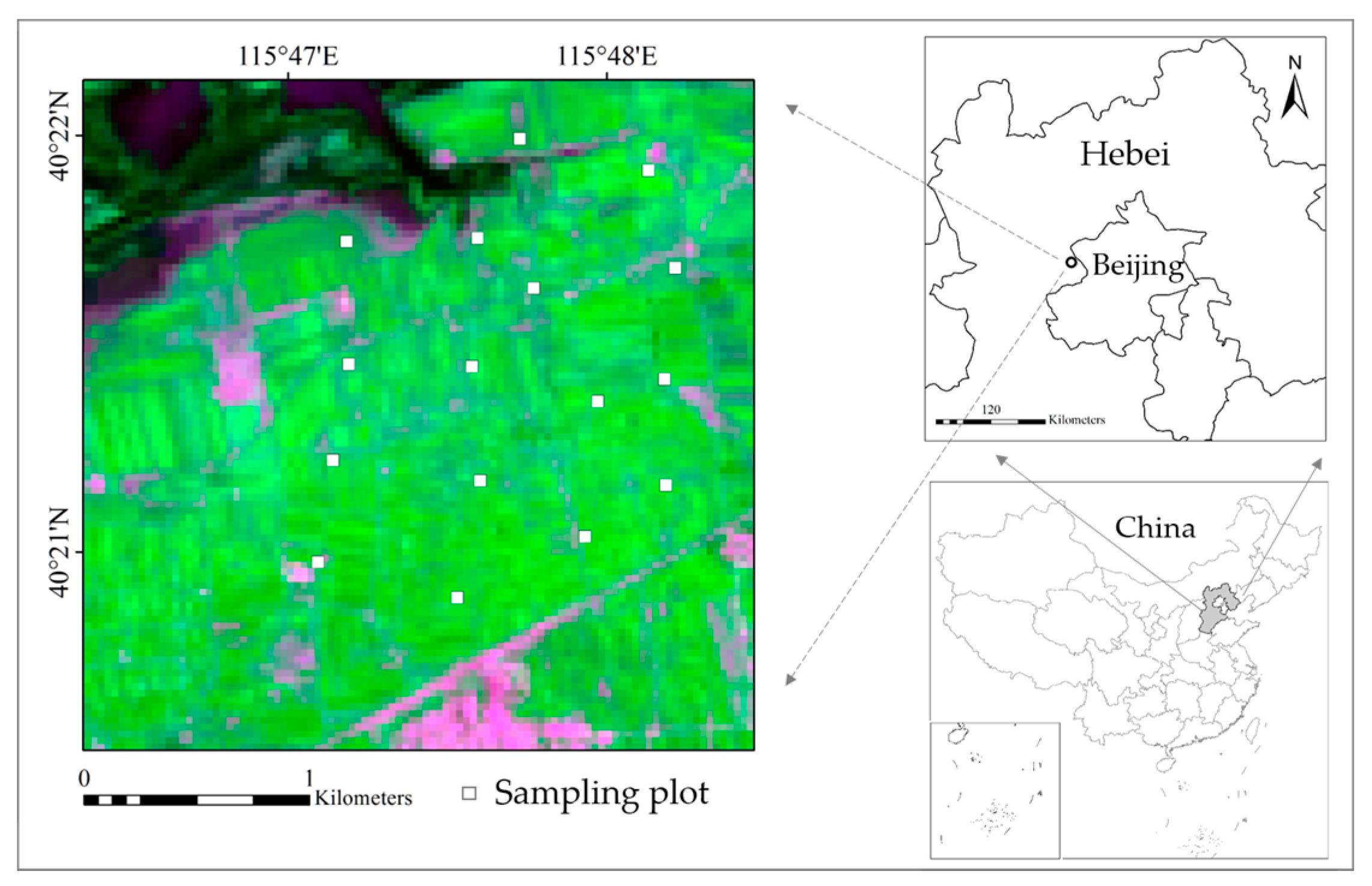
2.1. Study Area and Field LAI Measurements

The field experiment was conducted in a cropland site at Huailai of Hebei Province, China (115.77°E, 40.37°N, Figure 1) in 2013. The site was predominantly cultivated with maize (green region in Figure 1), but included numerous non-vegetation land cover types, such as a water area in the northwest corner, bare soil, and roads. As a crop typically grown in rows, maize was planted in late May and harvested in early October. We applied the nested spatial series method to conduct the spatial sampling, which was widely used in the field experiments [16]. As shown in Figure 1, there were 15 plots with a size of 30 m × 30 m over a 3 km × 3 km study area, where the LAI was measured in five sampling points per plot. The measurements from the five sampling points were averaged to provide a single value for each plot.
In the study area, a LAINet observation system [45] containing five measurement nodes for each plot was used to measure LAI between 3 July and 13 September. Each measurement node of the LAINet system automatically collected the multi–angle transmittance of the vegetation canopy during the day, and the LAI could then be calculated based on a direct light transmittance algorithm [45,51]. Although the maize grew normally, not all field measurements were valid, due to low battery levels and unexpected weather conditions. To better describe the vegetation growth characteristics, an aggregating window of eight days was used to smooth the valid LAI data. Hence, ten measurements at 15 plots were available (Table 1).
The LAI measurement from optical instruments corresponds to the effective plant area index that partially accounts for clumping effects [52]. In this study, we measured LAI during the period that the green LAI was dominant. In this experiment, two groups of LAI were simultaneously measured by the direct harvest method and LAINet system in a specially designed plot, with a size of 20 m × 20 m, and were used to calculate the ratio of effective LAI to true LAI. The ratio was 0.83 in our study, which was generally consistent with previous studies [40,52].

2.2. Landsat 8 Data

Landsat 8 Operational Land Imager (OLI) imagery was used to calculate the vegetation index to support the investigation of our proposed method. Three high-quality images were acquired on 6 July, 31 July, and 23 August, which corresponded to the field measurements on 3 July, 27 July, and 20 August, respectively (Table 1). The surface reflectance images, with nine bands (0.433–2.3 μm) at a spatial resolution of 30 m were downloaded from the United States Geological Survey (USGS) Earth Explorer [53] in Universal Transverse Mercator (UTM: WGS84) projection.

3. Methods

The PKB method to derivate high-resolution LAI maps with limited field measurements consists of four general steps (Figure 2): (1) constructing the prior knowledge base; (2) extracting a priori knowledge of the semi-empirical model parameters; (3) determining a semi-empirical model using the Bayesian inversion method; and (4) estimating high-resolution LAI maps from remote sensing data. Since accurate LAI estimation is largely dependent on a reliable model, we focus our efforts on the first three steps in this study.
Figure 2 shows that the prior knowledge is initially sourced from the published models and shared datasets in the universal sites, and finally present an initial guess and its uncertainty of each model parameter. The site used to extract a priori knowledge is called the universal site, to distinguish it from the study area to use this knowledge. This knowledge is combined with the local field measurements to calibrate the semi-empirical model. With the help of the auxiliary information provided by prior knowledge, even the local field measurements are limited in the study area, the modeling accuracy of empirical model can be improved by using the PKB method. This distinguishes the PKB method from the mostly other regression method to develop an empirical model. In the PKB method, the models are determined by a priori knowledge of model parameters and local field measurements, while in other regression method, the models are obtained based only on the local field measurements.

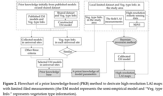
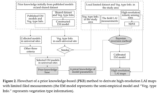
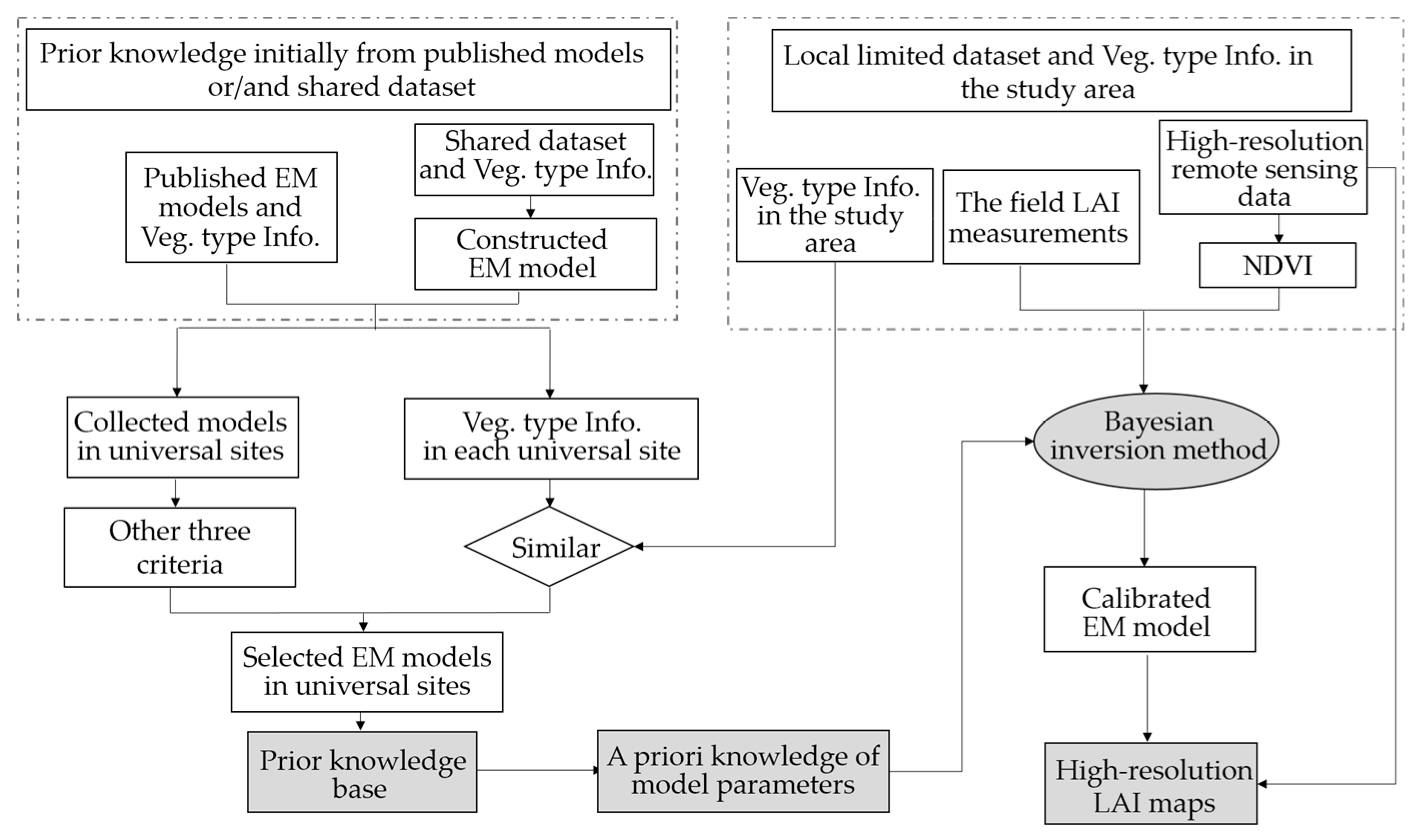
3.1. Extraction of a Priori Knowledge Regarding Model Parameters

3.1.1. The Semi-Empirical Model

The semi-empirical model [33] represents the relationships between LAI and vegetation index as:
V I = V I ( V I V I m i n ) × exp ( K V I × L A I )
where V I m i n is the vegetation index corresponding to that of bare soil; V I is the asymptotic value of VI when the LAI tends toward infinity; and K V I is the extinction coefficient according to the classical Beer's law, where the extinction coefficient describes the relative increase in VI due to an elementary increase in the LAI.
In this study, we used the NDVI to link LAI. The choice of vegetation index mainly depends on two aspects. First, this vegetation index is sensitive to LAI. The most commonly used vegetation indices for LAI estimation combine the information in visible and near infrared reflectance [21,30,33,36]. Since the visible domain reduces the perturbation of background soil, and the canopy reflectance in the near-infrared region is larger. Second, the collected semi-empirical models based on this vegetation index in the universal sites need to be as more as possible to support the extraction of prior knowledge. So far, NDVI is the most widely used vegetation index for LAI estimation in the literature. When the semi-empirical model is determined by LAI measurements and the corresponding Landsat NDVI, the LAI can be estimated from remote sensing data in a straight-forward manner using this model. If measurements are sufficient in the study area, a reliable model can be determined using regression method. However, if the measurements are limited, the accuracy of the model would be decreased, or there may not even be a least squares solution. In such a case, the a priori knowledge should be applied.

3.1.2. Construction of the Prior Knowledge Base

Figure 2 shows the process to extract a priori knowledge of model parameters, and a prior knowledge base is primarily constructed. The knowledge base is initially from the collected models from universal sites, including the published models in the articles and the constructed models using the shared dataset. When the collected model in the universal sites were used to extract prior knowledge, they should satisfy four criteria. First, the environmental conditions between the universal site and the study area should be similar. Since the environmental conditions can be used to represent the impact factors of the semi-empirical model, including canopy architecture, leaf optical properties, soil properties, and the solar/viewing direction [20,26,27,31,32,33]. The environmental conditions mainly contain the types of vegetation, phenology, geographical location, climate conditions, and soil status. However, we also need to consider the accessibility of the environmental conditions and the amount of the prior knowledge sources. In this study, only the vegetation type is used to select the appropriate sites for the construction of the prior knowledge base. This is because the vegetation type is not only a key variable influencing the empirical model, but also is a kind of accessible information.
Additionally, the model in the universal site should be satisfied other three criteria. Second, the semi-empirical model, given as Equation (1), is used to represent the relationship between the LAI and NDVI. Third, the land surface reflectance observations are acquired by remote sensing methods. Fourth, the local model is evaluated by the field measurements and is determined to have a highly credible performance.
Based on the above four criteria, we ultimately identified six published articles to establish the a priori knowledge base for crops, which can be used in our cropland site. Table 2 shows the parameter values of each model together with the essential details, such as crop types, time, and the location of the field experiments. The models were collected from different regions of the world, however, they all constructed the relationship between LAI and NDVI at cropland sites.

3.1.3. Extraction of a Priori Knowledge

When a knowledge base is built, the selected models are used to derive a priori knowledge, which is presented as an initial guess of each model parameter with the associated uncertainty. The initial guess of each parameter is obtained by averaging the parameter values of the selected models. The uncertainty of the initial guess of each model parameter is expressed as the standard deviation of parameter values of the selected published models. When the prior knowledge of model parameters is extracted, it is combined with the field measurements to calibrate a semi-empirical model by the Bayesian inversion method as discussed below.

3.2. Bayesian Inversion Method

Based on the Bayesian theorem, the inverse problem can be solved by searching the maximum posteriori probability ( ρ M ) of model parameters, which is related to the a priori probability:
P ( x | y o b s ) = P ( y o b s | x ) P ( x ) / P ( y o b s )
where x represents model parameters; yobs represents the actual observations; P(x) is the a priori probability of x; P ( y o b s ) = M P ( y o b s | x ) P ( x ) d x where M represents the model space of x and P(yobs|x) represents the conditional probability for yobs given x. The posteriori distribution P(x|yobs) represents all of the information after inversion from both a priori knowledge and observations. When all of the errors in the observation, model, and a priori knowledge are Gaussian, Tarantola (1987) gave the posteriori probability density of x as [54]:
ρ M ( x ) exp { 1 2 [ ( f ( x ) y o b s ) T C D 1 ( f ( x ) y o b s ) + ( x x p r i o r ) T C M 1 ( x x p r i o r ) ] }
where f(x) represents the simulated observations; xprior is the initial guess of the model parameters; CD is the covariance operator describing model and observation uncertainties; and CM is the covariance operator describing the uncertainties of xprior. Note that the first part in the square bracket of Equation (3) corresponds to the distance between the actual and simulated observations. The second part corresponds to the distance between the values of the determined parameters and those of the a priori knowledge. The inversion process is to search for an x to obtain the maximum value of a posteriori probability density to ensure the cost function J(x) is a minimum:
J ( x ) = 1 2 [ ( f ( x ) y o b s ) T C D 1 ( f ( x ) y o b s ) + ( x x p r i o r ) T C M 1 ( x x p r i o r ) ]
However, the covariance matrix of observations and a priori knowledge is difficult to obtain. The covariance matrix is usually considered to be diagonal, based on the assumption that the model parameters and observations are independent with each other. Then the cost function is as follows:
J ( x ) = 1 2 { i = 1 n [ f i ( x ) y i o b s σ i D ] 2 + j = 1 k [ x j x j p r i o r σ j M ] 2 }
where y i o b s and f i ( x ) are the ith actual and simulated observation, respectively; σ i D and σ j M are the standard deviation for the ith observation and a priori distribution of jth model parameter, respectively; x j is the determined result of the jth parameter; and x j p r i o r is the initial guess of the jth model parameter; n is the number of observations; and k is the number of parameters.
In this study, we obtained NDVI observations (yobs) from remote sensing data and the simulated NDVI values (f(x)) from the semi-empirical model, with LAI measurements as an input. The standard deviation of NDVI ( σ D) was set as 10% of the maximum NDVI value. The number of observations (n) was determined by the available field measurements and was usually limited in the study area as mentioned above. We aimed to determine the values of three model parameters (k = 3: K, N D V I and ND V I m i n ), which enabled a semi-empirical model for the study area to be constructed. The prior knowledge of the model parameters could be extracted as presented in Section 3.1.2. The cost function was constructed by combining the initial guess of the model parameter with associated uncertainty, and the limited field measurements, and was then iteratively minimized by the Shuffled Complex Evolution (SCE–UA) algorithm in MATLAB (The MathWorks, Inc., Natick, MA, USA) to calculate the model parameters [55]. The boundaries of semi-empirical model parameters used in SCE–UA algorithm were defined based on the NDVI statistics of the images and the published models listed in Table 2. When the semi-empirical model was determined, the LAI map could then be obtained from the remote sensing observations.

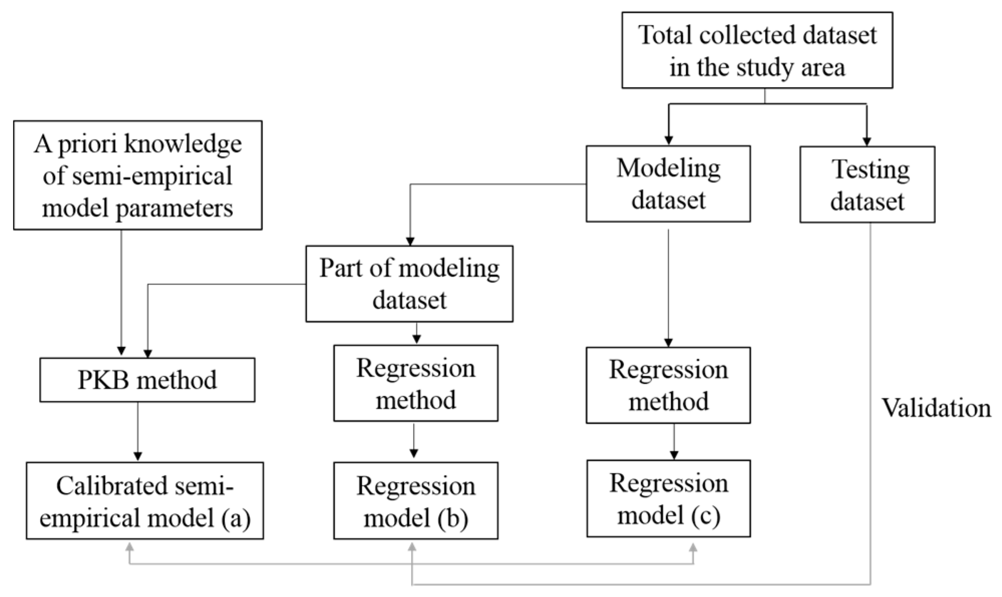
3.3. Evaluation Process and Statistical Metrics
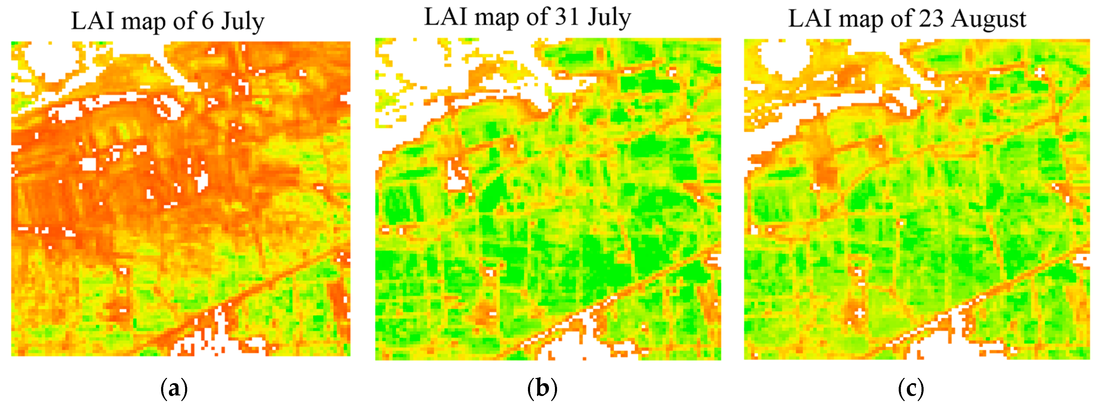
Figure 3 shows the process to evaluate the effectiveness of PKB method to improve the model accuracy under the “limited measurements” situations, compared with the performance of regression method. To assess the PKB method with the “limited measurements” situations, this situation should be defined. As discussed in the introduction section, the limited measurements are difficult to represent the entire study area and, thus, reduce the model accuracy based on the regression method. We used the local part dataset of different sample sizes to evaluate the effectiveness of the PKB method. In this study, we divided the total collected dataset into two subsets: 65% of the data was taken as the modeling dataset and the remainder for the independent testing dataset. Figure 3 shows that the part of modeling dataset was combined with a priori knowledge of model parameters to calibrate the semi-empirical model based on PKB method. The performance of this model was then compared with the model produced by the regression method for this part dataset, to test whether the PKB method can improve the model accuracy. Meanwhile, the model based on the modeling dataset, taken as the best result, was used to compare with the model produced by the PKB method for the part dataset.
According to the above statement, overall, we primarily evaluated the effectiveness of the PKB method under “limited measurements” situations by analyzing the performance of the PKB method with different local sample sizes. We then selected a typical group of the limited dataset from the modeling dataset to further evaluated PKB method. The testing dataset was applied to evaluate each model.
The root mean square error (RMSE) was used to quantify the deviation between two datasets:
RMSE = 1 N × i = 1 N ( y i y ^ i ) 2
where N is the number of samples used for the comparison; and y i and y ^ i are the reference and comparison data, respectively.
To quantify the performance of the model, we calculated the RMSE and bias between the measured and estimated LAI from the testing dataset. The correlation coefficient (r) and range error ratio (RER) were also used to assess the practical efficiency of the model [56,57]. Essentially, empirical thresholds have been defined based on RER, because models with an RER of less than 3 have little practical utility, while values between 3 and 10 indicate a limited practical utility, and values above 10 show that the model has a high utility value:
RER = y m a x y m i n RMSE
where y m a x and y m i n are the maximum and minimum LAI measurements, respectively. The RMSE was derived from the testing dataset values for the measured and estimated LAI values.

4. Results

4.1. A Priori Knowledge for Crops

Based on the extraction method of a priori knowledge as shown in Section 3.1, we obtained a priori knowledge of model parameters for crops from the six published models in different cropland sites listed in Table 2. Table 3 shows the initial guessed values and uncertainty of semi-empirical model parameters, which were then used to determine the model for our study area combined with the local field measurements based on our proposed PKB method.

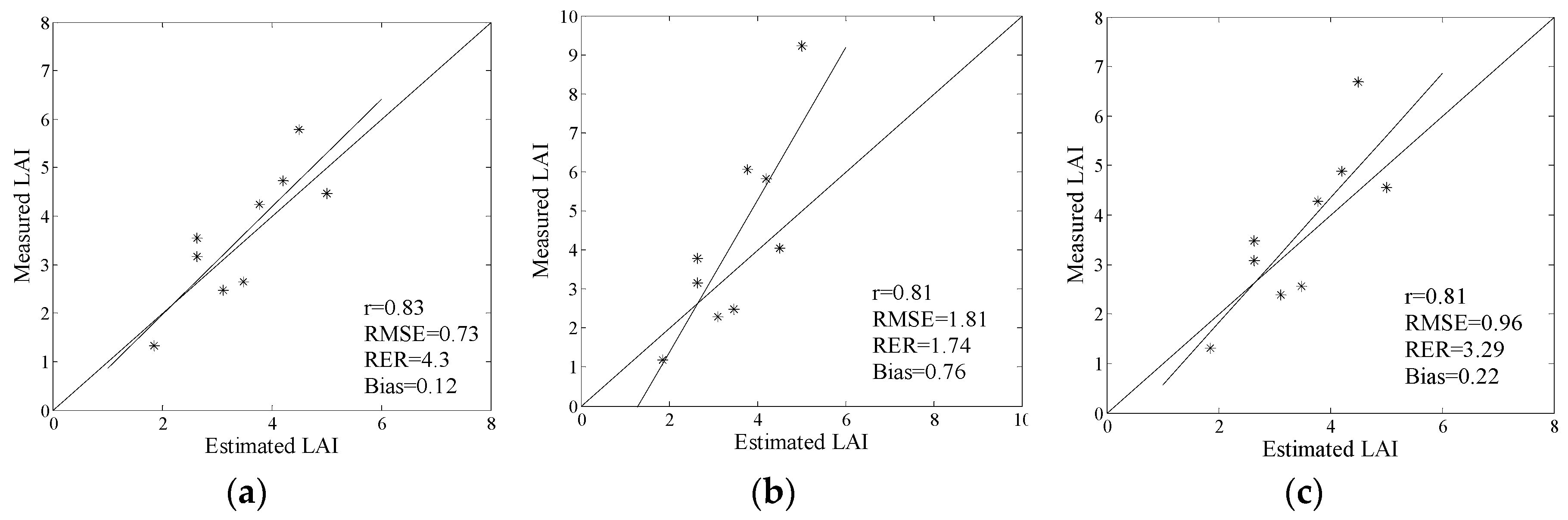
4.2. Evaluation of Our Method

In our study, the field LAI measurements for maize were collected during several growing seasons over 15 plots. However, not all field measurements were complete, and only a few Landsat images were acquired during the study period due to clouds and other acquisition issues. Nevertheless, we collated the available NDVI from Landsat with field LAI measurements and, in total, collected 28 pairs of data available (each pair comprising one NDVI value and one corresponding LAI value roughly equivalent to a single Landsat pixel). A 65% subset of the data (19 pairs) was used as modeling dataset, with the remaining data (nine pairs) used to validate the results.
We evaluated the effectiveness of PKB method integrating a priori knowledge of model parameters to improve the model accuracy under “limited measurements” situations according to the process depicted in Section 3.3. We primarily analyzed the sensitivity of PKB method with the local sample size to evaluate the overall effectiveness of the PKB method under different ‘limited measurements’ situations. We then further evaluated the PKB method using a typical group of the limited dataset. The model from PKB method was compared with performance of model based on the regression method.

4.2.1. Impact of the Local Sample Size

We analyzed the impact of local sample size on the PKB methods to evaluate the effectiveness of this method under the ‘limited measurements’ situations. To assess this impact, each sample size (5–19) was repeatedly and randomly sampled from the modeling dataset. Each group of the dataset was then applied to update the initial guessed values of the model parameters to reduce the uncertainty of the prior knowledge. The calibrated semi-empirical model was evaluated by the testing data and RMSE was calculated as shown in Figure 4. The regression method was also applied to each dataset to obtain the semi-empirical model, which was then evaluated by the testing data.
Figure 4 shows that, although the local sample size decreased from 19 to five, the PKB method produced almost consistently low mean RMSE values (around 0.72). However, the local sample size had a significant influence on the regression method, with a sharp increase in mean RMSE values from 0.96 to 1.73 and with larger uncertainties as sample size decreased. This indicates that the PKB method can effectively improve the model accuracy when the collected dataset is not enough in the study area, such as, only five or six data pairs available.

4.2.2. Evaluation Using the Limited Dataset Case

In this section, we further evaluated the effectiveness of the PKB method in the form of limited dataset case. We selected a typical group of seven data pairs from the modeling dataset, which was difficult to represent the entire study area. The PKB method integrated the initial guessed values of the model parameters with the related uncertainty of the model parameters, and this limited dataset determined a semi-empirical model. The testing data was used to evaluate the model and the RMSE was determined. The performance of the PKB method for this limited dataset was compared with that of the regression method for this limited dataset and the modeling dataset.
Table 4 shows the statistics of the LAI measurements and NDVI in the limited, modeling, total collected, and testing datasets. It can be seen that the distribution of the limited dataset deviated from that of the total dataset in the study area, while the distribution of the dataset and testing dataset generally matched that of the total data.
Figure 5a,b shows that, with the limited dataset, the PKB method produced a better LAI estimation accuracy (0.73 for RMSE and 0.12 for bias) than the regression method (1.81 for RMSE and 0.76 for bias). The model practical utility from regression method was low (RER = 1.74), but this was improved by using the PKB method (RER = 4.3). Figure 5b shows that the LAI estimation was obviously incorrect, especially in the higher value region (LAI > 3.5). This was because the limited dataset was insufficient to represent the entire study area, which reduced the model accuracy based on the regression method. However, the proposed PKB method can make full use of the extracted prior knowledge of model parameters for crops to make up data deficiencies and improve model accuracy for our cropland site. The importance of prior knowledge to improve the model accuracy can also be clearly identified by the comparison of results as shown in Figure 5a,c. The PKB method combing prior knowledge of model parameters with the seven data pairs, producing a better LAI estimation accuracy than the regression method using 19 data pairs (0.96 for RMSE and 0.22 for bias).
The results show that even with the limited dataset, the PKB method produced a more accurate model for our Huailai cropland site ( V I = 0.9, V I m i n = 0.05 and K = 0.53). The prior knowledge derived from the six published models at different cropland sites provided representative initial guessed values of model parameters for our cropland site ( V I = 0.92, V I m i n = 0.08 and K = 0.58), which were used in the PKB method. However, an accurate model could not be obtained ( V I = 0.82, V I m i n = 0.0 and K = 0.74) based on the regression method for the limited dataset. The results of the case study indicate that the extracted prior knowledge of model parameters for crops can increase the effective information to improve the representativeness of the empirical model by using PKB, when limited field measurements were available in the study area.
Figure 6 shows the estimated high-resolution LAI maps from three OLI images using the model based on the PKB method for the limited dataset. The evaluated result of this model is represented in Figure 5a and explained above. The LAI maps presented the temporal-spatial pattern of maize LAI in this study area. With regard to the temporal pattern, the maps show that LAI maintained a dramatically-increasing trend in July and then declined toward the end of August. In terms of the spatial pattern, the maize dominant area generally had a larger LAI than regions with a mixture of non-vegetation class land cover types.

5. Discussion

High-resolution LAI maps can provide important information for the ecological and crop growth studies, as well as the validation of LAI products [9,10,11,12,13,14,15,16,17,18]. Existing empirical methods often require enough measurements to represent the LAI-VI relationship throughout the study area. However, obtaining enough samples still remains challenging. This is often the case if only legacy measurements are available, or if field work is too expensive or difficult to collect fully representative data [16,17,18,44,45]. In this study, a novel method named PKB method was proposed to relax the requirements regarding the amount of field measurements using existing empirical methods. The method was evaluated using the dataset over a cropland site in Hebei Province, China. The results indicated that this method presented a promising potential to improve the accuracy of models, when the local measurements were limited. High-resolution LAI maps can then be estimated from remote sensing observations in the study area.
The empirical method has various advantages fostering its widespread use, such as explicit expression, fast process, and efficient computation [27,28]. Our study thus concentrated on this kind of method to estimate LAI from remote sensing images. To determine an empirical model, the proposed PKB method makes full use of a priori knowledge, which distinguishes it from the existing empirical methods that only depend on local field measurements. The prior knowledge can provide important auxiliary information to determine empirical model, which ensures the suitability of PKB method in “limited measurements” situations. The result shows that, compared with regression method, the PKB method effectively improved the model accuracy with limited field measurements. The case study shows that the PKB method produced a better estimation accuracy (RMSE = 0.73) than the regression method (RMSE = 1.81), when only seven data pairs were used.
While being successful in many studies, the empirical method suffers from drawbacks, as well [27,28]. For example, a developed empirical model based on the local field measurements in one area often does not work well when applied in other areas. Since the model is sensitive to the various factors such as environmental conditions, canopy characteristics and sun/viewing geometry [3,20,29,30]. In this aspect, our proposed method may provide a way to use the existing models to improve the accuracy of empirical model in a given study area based on the form of a priori knowledge, rather than directly using the published model to estimate LAI in the other areas. The prior knowledge is derived from the published models or shared dataset in the universal sites, and presents an initial guess of each model parameter with the associated uncertainty. This is consistent with the conclusion of previous studies that a priori knowledge provides more reliable, consistent, and generally applicable information for successful inversions [46,47,48,49,50]. As well, our developed semi-empirical model in this study can be used to extend the prior knowledge base for crops.
It is clear that the representativeness of a prior knowledge base is the key to the success of the PKB method. As described above, the prior knowledge is impacted by various factors, since this knowledge is extracted from collected models under different measurement conditions [20,26,27,31,32,33]. When regarding the impact factors characterized by environmental conditions, our ultimate goal is to describe the similarity of models between a universal site and a given study area, and all environmental conditions should be considered. However, we also need to consider the accessibility of the environmental conditions and the amount of the prior knowledge sources. In our study, only the vegetation type was used to select the appropriate sites for a priori knowledge extraction. This was because the vegetation type was not only a key variable influencing the empirical model, but was also a kind of accessible information. The results show that the extracted prior knowledge from the published models at cropland sites greatly reduced the influence of the shortcomings of limited field measurements on the accuracy of empirical models. With the increased field experiments, more vegetation types and environmental conditions would be used, such as the geographical location and climate conditions.
A large number of empirical models have been established and evaluated, and a wide range of deviations (0.28 < RMSE < 0.77) between estimated and measured LAI were found [28,29,36,37,38,39]. Even all modeling dataset was used (N = 19), a lower LAI estimation accuracy (RMSE = 0.96) was produced by regression method. One way to improve model accuracy is to acquire more data in the study area, but this way is often high-cost [44,45]. This study represented another way is the use of prior knowledge of model parameters in improving the model accuracy. Based on our dataset, we can have the basic conclusion that the proposed PKB method can improve the modeling accuracy of the empirical model with limited field measurements, comparing with other regression methods (RMSE = 0.7, N = 19).

6. Conclusions

This study is primarily motivated by the deficiencies in the existing empirical methods for constructing reliable empirical models, when field measurements are limited. This study developed a PKB method to address this issue. In this method, the collected models in universal sites are selected to construct an a priori knowledge base for the study area. A priori knowledge of the semi-empirical model parameters is extracted based on selected models in the base, and then combined with local data to calibrate a semi-empirical model using the Bayesian inversion method.
The proposed method was evaluated in a cropland area, and results show that the proposed PKB can significantly improve the accuracy of an empirical model when limited measurements were available in the study area. The limited dataset case study shows that the PKB method produced more accurate LAI estimation (RMSE = 0.73) than the regression method (RMSE = 1.81), when only seven data pairs were used to obtain the relationship between LAI and NDVI. A priori knowledge for crops extracted from published models in the universal sites can increase the effective information to determine the empirical model in our study area.
In this study, we investigated the effectiveness of a PKB method at a cropland site. In the future, we intend to build a more representative a priori knowledge base for different vegetation types based on further field experiments.

Acknowledgments

This research was supported by the National Basic Research Program of China under grant No. 2013CB733403, and the National Natural Science Foundation of China under grant No. 41171263.

Author Contributions

Yuechan Shi designed the framework of this research work and wrote the manuscript; Jindi Wang proposed the main idea and gave important guidance on the work and checked the writing; Jian Wang contributed materials; and Yonghua Qu provided the field data.

Conflicts of Interest

The authors declare no conflict of interest.

References

  1. Chen, J.M.; Black, T.A. Defining leaf area index for non-flat leaves. Plant Cell Environ. 1992, 15, 421–429. [Google Scholar] [CrossRef]
  2. Abuelgasim, A.A.; Fernandes, R.A.; Leblanc, S.G. Evaluation of national and global LAI products derived from optical remote sensing instruments over Canada. IEEE Trans. Geosci. Remote Sens. 2006, 44, 1872–1884. [Google Scholar] [CrossRef]
  3. Verrelst, J.; Camps-Valls, G.; Muñoz-Marí, J.; Rivera, J.P.; Veroustraete, F.; Cleversc, J.P.W.; Moreno, J. Optical remote sensing and the retrieval of terrestrial vegetation bio-geophysical properties—A review. ISPRS J. Photogramm. Remote Sens. 2015, 108, 273–290. [Google Scholar] [CrossRef]
  4. Curnel, Y.; de Wit, A.J.; Duveiller, G.; Defourny, P. Potential performances of remote sensing LAI assimilation in WOFOST model based on an OSS Experiment. Agric. For. Meteorol. 2011, 151, 1843–1855. [Google Scholar] [CrossRef]
  5. Yuan, H.; Dai, Y.; Xiao, Z.; Ji, D.; Shang guan, W. Reprocessing the MODIS leaf area index products for land surface and climate modelling. Remote Sens. Environ. 2011, 115, 1171–1187. [Google Scholar] [CrossRef]
  6. Baret, F.; Weiss, M.; Lacaze, R.; Camacho, F.; Makhmara, H.; Pacholcyzk, P.; Smets, B. GEOV1: LAI and FAPAR essential climate variables and FCOVER global time series capitalizing over existing products. Part1: Principles of development and production. Remote Sens. Environ. 2013, 137, 299–309. [Google Scholar] [CrossRef]
  7. Barr, A.G.; Black, T.A.; Hogg, E.H.; Kljun, N.; Morgenstern, K.; Nesic, Z. Inter-annual variability in the leaf area index of a boreal aspen-hazelnut forest in relation to net ecosystem production. Agric. For. Meteorol. 2004, 126, 237–255. [Google Scholar] [CrossRef]
  8. Song, C.; Dickinson, M.B. Extracting forest canopy structure from spatial information of high resolution optical imagery: Tree crown size versus leaf area index. Int. J. Remote Sens. 2008, 29, 5605–5622. [Google Scholar] [CrossRef]
  9. Anderson, M.C.; Kustas, W.P.; Alfieri, J.G.; Gao, F.; Hain, C.; Prueger, J.H.; Evett, S.; Colaizzi, P.; Howell, T.; Chavez, J.L. Mapping daily evapotranspiration at Landsat spatial scales during the BEAREX’08 field campaign. Adv. Water Resour. 2012, 50, 162–177. [Google Scholar] [CrossRef]
  10. Duveiller, G.; Baret, F.; Defourny, P. Remote sensing green area index for winter wheat crop monitoring: 10-year assessment at regional scale over a fragmented landscape. Agric. For. Meteorol. 2012, 152, 156–168. [Google Scholar] [CrossRef]
  11. Gitelson, A.A.; Peng, Y.; Arkebauer, T.J.; Schepers, J. Relationships between gross primary production, green LAI, and canopy chlorophyll content in maize: Implications for remote sensing of primary production. Remote Sens. Environ. 2014, 144, 65–72. [Google Scholar] [CrossRef]
  12. Dorigo, W.A.; Zurita-Milla, R.; de Wit, A.J.W.; Brazile, J.; Singh, R.; Schaepman, M.E. A review on reflective remote sensing and data assimilation techniques for enhanced agroecosystem modeling. Int. J. Appl. Earth Obs. Geoinf. 2007, 9, 165–193. [Google Scholar] [CrossRef]
  13. Houborg, R.; McCabe, M.F.; Gao, F. A Spatio-Temporal Enhancement Method for medium resolution LAI (STEM-LAI). Int. J. Appl. Earth Obs. Geoinf. 2016, 47, 15–29. [Google Scholar] [CrossRef]
  14. Dusseux, P.; Hubert-Moy, L.; Corpetti, T.; Vertès, F. Evaluation of SPOT imagery for the estimation of grassland biomass. Int. J. Appl. Earth Obs. Geoinf. 2015, 38, 72–77. [Google Scholar] [CrossRef]
  15. Ganguly, S.; Nemani, R.R.; Zhang, G.; Hashimoto, H.; Milesi, C.; Michaelis, A.; Wang, W.; Votava, P.; Samanta, A.; Melton, F.; et al. Generating global leaf area index from Landsat: Algorithm formulation and demonstration. Remote Sens. Environ. 2012, 122, 185–202. [Google Scholar] [CrossRef]
  16. Morisette, J.T.; Baret, F.; Privette, J.L.; Myneni, R.B.; Nickeson, J.E.; Garrigues, S.; Shabanov, N.V.; Weiss, M.; Fernandes, R.A.; Leblanc, S.G.; et al. Validation of global medium-resolution LAI Products: A framework proposed within the CEOS Land Product Validation subgroup. IEEE Trans. Geosci. Remote Sens. 2006, 44, 1804–1817. [Google Scholar] [CrossRef]
  17. Weiss, M.; Baret, F.; Block, T.; Koetz, B.; Burini, A.; Scholze, B.; Lecharpentier, P.; Brockmann, C.; Fernandes, R.; Plummer, S.; et al. On Line Validation Exercise (OLIVE): A web based service for the validation of medium resolution land products. Application to FAPAR products. Remote Sens. 2014, 6, 4190–4216. [Google Scholar] [CrossRef]
  18. Fernandes, R.; Plummer, S.; Nightingale, J.; Baret, F.; Camacho, F.; Fang, H.; Garrigues, S.; Gobron, N.; Lang, M.; Lacaze, R.; et al. Global leaf area index product validation good practices. CEOS Working Group on Calibration and Validation-Land Product Validation Sub-Group, 2nd ed. Available online: http://lpvs.gsfc.nasa.gov/LAI_home.html (accessed on 22 December 2016).
  19. Baret, F.; Buis, S. Estimating canopy characteristics from remote sensing observations: Review of methods and associated problems. In Advances in Land Remote Sensing: System, Modeling, Inversion and Application; Liang, S., Ed.; Springer Science and Business Media B.V.: Dordrecht, The Netherlands, 2008; pp. 173–201. [Google Scholar]
  20. Rivera, J.P.; Verrelst, J.; Delegido, J.; Veroustraete, F.; Moreno, J. On the semi-automatic retrieval of biophysical parameters based on spectral index optimization. Remote Sens. 2014, 6, 4927–4951. [Google Scholar] [CrossRef]
  21. Chen, J.M.; Pavlic, G.; Brown, L.; Cihlar, J.; Leblanc, S.G.; White, H.P.; Hall, R.J.; Peddle, D.R.; King, D.J.; Trofymow, J.A.; et al. Derivation and validation of Canada-wide coarse-resolution leaf area index maps using high-resolution satellite imagery and ground measurements. Remote Sens. Environ. 2002, 80, 165–184. [Google Scholar] [CrossRef]
  22. Cohen, W.B.; Maiersperger, T.K.; Gower, S.T.; Turner, D.P. An improved strategy for regression of biophysical variables and Landsat ETM+ data. Remote Sens. Environ. 2003, 84, 561–571. [Google Scholar] [CrossRef]
  23. Martinez, B.; García-Haro, F.J.; Camacho-de Coca, F. Derivation of high-resolution leaf area index maps in support of validation activities: Application to the cropland Barrax site. Agric. For. Meteorol. 2009, 149, 130–145. [Google Scholar] [CrossRef]
  24. Shi, Y.C.; Wang, J.D.; Qin, J.; Qu, Y. An upscaling algorithm to obtain the representative ground truth of LAI time series in heterogeneous land surface. Remote Sens. 2015, 7, 12887–12908. [Google Scholar] [CrossRef]
  25. Le Maire, G.; François, C.; Soudani, K.; Berveiller, D.; Pontailler, J.Y.; Bréda, N.; Genet, H.; Davi, H.; Dufrêne, E. Calibration and validation of hyperspectral indices for the estimation of broadleaved forest leaf chlorophyll content, leaf mass per area, leaf area index and leaf canopy biomass. Remote Sens. Environ. 2008, 112, 3846–3864. [Google Scholar] [CrossRef]
  26. Aparicio, N.; Villegas, D.; Araus, J.L.; Casadesus, J.; Royo, C. Relationship between growth traits and spectral vegetation indices in durum wheat. Crop Sci. 2002, 42, 1547–1555. [Google Scholar] [CrossRef]
  27. Atzberger, C.; Darvishzadeh, R.; Immitzer, M.; Schlerf, M.; Skidmore, A.; le Maire, G. Comparative analysis of different retrieval methods for mapping grassland leaf area index using airborne imaging spectroscopy. Int. J. Appl. Earth Obs. Geoinf. 2015, 43, 19–31. [Google Scholar] [CrossRef]
  28. Verrelst, J.; Rivera, J.P.; Veroustraete, F.; Muñoz-Marí, J.; Clevers, j.P.W.; Camps-Valls, G.; Morenoa, J. Experimental Sentinel-2 LAI estimation using parametric, non-parametric and physical retrieval methods–A comparison. ISPRS J. Photogramm. Remote Sens. 2015, 108, 260–272. [Google Scholar] [CrossRef]
  29. Haboudane, D.; Miller, J.; Pattey, E.; Zarco-Tejada, P.; Strachan, I. Hyperspectral vegetation indices and novel algorithms for predicting green LAI of crop canopies: Modeling and validation in the context of precision agriculture. Remote Sens. Environ. 2004, 90, 337–352. [Google Scholar] [CrossRef]
  30. Li, X.; Zhang, Y.; Luo, J.; Jin, X.; Xu, Y.; Yang, W. Quantification winter wheat LAI with HJ-1CCD image features over multiple growing seasons. Int. J. Appl. Earth Obs. Geoinf. 2016, 44, 104–112. [Google Scholar] [CrossRef]
  31. Delegido, J.; Verrelst, J.; Alonso, L.; Moreno, J. Evaluation of sentinel-2 red edge bands for empirical estimation of green LAI and chlorophyll content. Sensors 2011, 11, 7063–7081. [Google Scholar] [CrossRef] [PubMed]
  32. Ross, J. The Radiation Regime and Architecture of Plant Stands; Dr. W. Junk: London, UK, 1981. [Google Scholar]
  33. Baret, F.; Guyot, G. Potentials and limits of vegetation indices for LAI and FAPAR assessment. Remote Sens. Environ. 1991, 35, 161–173. [Google Scholar] [CrossRef]
  34. Nilson, T. A theoretical analysis of the frequency of gaps in plant stands. Agric. Meteorol. 1971, 8, 25–38. [Google Scholar] [CrossRef]
  35. Carlson, T.N.; Ripley, D.A. On the relation between NDVI, fractional vegetation cover, and leaf area index. Remote Sens. Environ. 1997, 62, 241–252. [Google Scholar] [CrossRef]
  36. Liu, J.; Pattey, E.; Jégo, G. Assessment of vegetation indices for regional crop green LAI estimation from Landsat images over multiple growing seasons. Remote Sens. Environ. 2012, 123, 347–358. [Google Scholar] [CrossRef]
  37. Bsaibes, A.; Courault, D.; Baret, F.; Weiss, M.; Olioso, A.; Jacob, F.; Kzemipour, F. Albedo and LAI estimates from FORMOSAT-2 data for crop monitoring. Remote Sens. Environ. 2009, 113, 716–729. [Google Scholar] [CrossRef]
  38. Verger, A.; Baret, F.; Camacho, F. Optimal modalities for radiative transfer-neural network estimation of canopy biophysical characteristics: Evaluation over an agricultural area with CHRIS/PROBA observations. Remote Sens. Environ. 2011, 115, 415–426. [Google Scholar] [CrossRef]
  39. Weiss, M.; Baret, F.; Leroy, M.; Hautecoeur, O.; Bacour, C.; Prevol, L.; Bruguier, N. Validation of neural net techniques to estimate canopy biophysical variables from remote sensing data. Agronomie 2002, 22, 547–554. [Google Scholar] [CrossRef]
  40. Liu, Y.; Wang, J.D.; Zhou, H.M.; Xue, H.Z. LAI measuring data processing, analysis and spatial scaling in the middle reaches of heihe experimental research region. Remote Sens. Technol. Appl. 2010, 18, 1189–1198. [Google Scholar]
  41. Zhang, R.H. Quantitative Thermal Infrared Remote Sensing Model and Ground Experimental Base; Science Press: Beijing, China, 2013; Chapter 4; pp. 172–174. (In Chinese) [Google Scholar]
  42. Walthall, C. A comparison of empirical and neural network approaches for estimating maize and soybean leaf area index from Landsat ETM+ imagery. Remote Sens. Environ. 2004, 92, 465–474. [Google Scholar] [CrossRef]
  43. Wilson, T.B.; Meyers, T.P. Determining vegetation indices from solar and photosynthetically active radiation fluxes. Agric. For. Meteorol. 2007, 144, 160–179. [Google Scholar] [CrossRef]
  44. Fang, H.; Li, W.; Wei, S.; Jiang, C. Seasonal variation of leaf area index (LAI) over paddy rice fields in NE China: Intercomparison of destructive sampling, LAI-2200, digital hemispherical photography (DHP), and AccuPAR methods. Agric. For. Meteorol. 2014, 198, 126–141. [Google Scholar] [CrossRef]
  45. Qu, Y.H.; Zhu, Y.Q.; Han, W.C.; Wang, J.D.; Ma, M.G. Crop leaf area index observations with a wireless sensor network and its potential for validating remote sensing products. IEEE J. Sel. Top. Appl. Earth Obs. Remote Sens. 2014, 7, 431–444. [Google Scholar] [CrossRef]
  46. Li, X.; Wang, J.; Hu, B.; Strahler, A. On utilization of prior knowledge in inversion 556 of remote sensing models. Sci. China Ser. D 1998, 580–586. [Google Scholar] [CrossRef]
  47. Li, X.; Gao, F.; Wang, J.; Strahler, A. A priori knowledge accumulation and its application to linear BRDF model inversion. J. Geophys. Res. Atmos. 2001, 106, 11925–11935. [Google Scholar] [CrossRef]
  48. Combal, B.; Baret, F.; Weiss, M.; Trubuil, A.; Mace, D.; Pragnere, A.; Wang, L. Retrieval of canopy biophysical variables from bidirectional reflectance: Using prior information to solve the ill-posed inverse problem. Remote Sens. Environ. 2003, 84, 1–15. [Google Scholar] [CrossRef]
  49. Yan, G.; Mu, X.; Ma, Y.; Li, Z.L. A strategy to integrate a priori knowledge for an improved inversion of the LAI from BRDF modelling. Int. J. Remote Sens. 2008, 29, 4927–4941. [Google Scholar] [CrossRef]
  50. Wang, J.; Li, X. The spectrum knowledge base of typical objects and remote sensing inversion of land surface parameters. J. Remote Sens. 2004, 8, 4–7. [Google Scholar]
  51. Qu, Y.H.; Wang, J.D.; Dong, J.; Jiang, F.B. Design and experiment of crop structural parameters automatic measurement system. Trans. CSAE 2012, 28, 160–165. (In Chinese) [Google Scholar]
  52. Ryu, Y.; Nilson, T.; Kobayashi, H.; Sonnentag, O.; Law, B.E.; Baldocchi, D.D. On the correct estimation of effective leaf area index: Does it reveal information on clumping effects? Remote Sens. Environ. 2010, 150, 463–472. [Google Scholar] [CrossRef]
  53. Earth Explorer. Available online: http://earthexplorer.usgs.gov/ (accessed on 6 July 2015).
  54. Tarantola, A. Inverse Problem Theory: Methods for Data Fitting and Model Parameter Estimation; Elsevier Science: New York, NY, USA, 1987. [Google Scholar]
  55. Duan, Q.Y.; Sorooshian, S.; Gupta, V.K. Effective and efficient global optimization for conceptual rainfall-runoff models. Water Resour. Res. 1992, 28, 1015–1031. [Google Scholar] [CrossRef]
  56. De, G.A.; Lippolis, V.; Nordkvist, E.; Visconti, A. Rapid and non-invasive analysis of deoxynivalenol in durum and common wheat by Fourier-transform near infrared (FT-NIR) spectroscopy. Food Addit. Contam. 2009, 26, 907–917. [Google Scholar]
  57. Páscoa, R.N.M.J.; Machado, S.; Magalhães, L.M.; João, A.L. Value adding to red grape pomace exploiting eco-friendly FT-NIR spectroscopy technique. Food Bioprocess Technol. 2015, 8, 865–874. [Google Scholar] [CrossRef]
Figure 1. Location of the study area (false color composite Landsat 8 image acquired on 31 July 2013, R/G/B vs. band2/band5/band3), and sampling plots distributed in 3 km × 3 km area.
Remotesensing 09 00013 g001
Figure 2. Flowchart of a prior knowledge-based (PKB) method to derivate high-resolution LAI maps with limited filed measurements (the EM model represents the semi-empirical model and “Veg. type Info.” represents vegetation type information).
Remotesensing 09 00013 g002
Figure 3. Process to evaluate whether the PKB method integrating a priori knowledge of model parameters can improve the model accuracy with the limited dataset, compared with the regression method.
Remotesensing 09 00013 g003
Figure 4. Accuracy (RMSE) of LAI estimates using PKB method and regression method. For each sample size, fifty replicates were randomly selected to construct the empirical model and then evaluated by the testing data. The gray area indicates the standard deviation of accuracy around the mean RMSE (black dash line) obtained by PKB method. The cyan area indicates the standard deviation of accuracy around the mean RMSE (blue solid line) obtained by regression method.
Remotesensing 09 00013 g004
Figure 5. Evaluation of the models constructed from (a) the PKB method for the limited dataset; (b) the regression method for the limited dataset; and (c) the regression method for modeling dataset.
Remotesensing 09 00013 g005
Figure 6. The estimated high-resolution LAI maps using the model based on PKB method for the limited dataset: (a) on 6 July; (b) 31 July; and (c) 23 August 2013.
Remotesensing 09 00013 g006
Table 1. Landsat data corresponding to field leaf area index (LAI) measurement dates.
Field LAI3 July11 July19 July27 July4 August12 August20 August28 August5 September13 September
Landsat6 July 31 July 23 August
Table 2. A priori knowledge base for crops consisting of six published models.
ReferenceCrop TypeField ExperimentAcquired MethodsModel Parameters
TimeLocationLAI Meas.ObservationK N D V I N D V I m i n
Liu et al. [36]Mixed1999–2006Ottawa, CanadaLAI2000Landsat0.650.980.07
Bsaibes et al. [37]Mixed2006Southeast, FranceDHPFormosat20.710.890.10
Verger et al. [38]Mixed2009Barrax, SpainDHP/LAI2000PROBA0.600.910.12
Weiss et al. [39]Mixed2001Alpilles, FranceHarvestPolder0.670.960.13
Liu et al. [40]Maize2008Gansu, ChinaDHP/LAI2000ASTER/Landsat0.360.800.05
Zhang et al. [41]Mixed1987–1991Shandong, ChinaHarvestTower0.501.000.00
DHP is digital hemispherical photographs.
Table 3. A priori knowledge of model parameters for crops.
Component of the Prior KnowledgeK N D V I N D V I m i n
Initial guess0.580.920.08
Uncertainty0.130.0740.049
Table 4. Statistics of the LAI and normalized difference vegetation index (NDVI) in the limited, modeling, and testing dataset, compared with the total collected dataset in the study area.
Data SetsNo.LAINDVI
MinMaxMedianMean σ MinMaxMedianMean σ
Limited dataset71.925.964.364.151.460.570.8900.760.760.10
Modeling dataset191.335.963.173.451.320.370.890.770.730.14
Testing dataset91.855.013.483.471.010.480.860.770.740.12
Total dataset281.335.963.193.461.210.370.890.770.740.13

