Article

Remote Sensing-Based Assessment of the 2005–2011 Bamboo Reproductive Event in the Arakan Mountain Range and Its Relation with Wildfires

1
International Livestock Research Institute, P.O. Box 30709, Nairobi 00100, Kenya
2
Remote Sensing of Environmental Dynamics Lab., Dept. of Earth and Environmental Sciences, University of Milano-Bicocca, Piazza della Scienza 1, Milano 20126, Italy
*
Author to whom correspondence should be addressed.
Remote Sens. 2017, 9(1), 85; https://doi.org/10.3390/rs9010085
Submission received: 26 July 2016 / Revised: 28 November 2016 / Accepted: 11 January 2017 / Published: 18 January 2017

Abstract

:
Pulse ecological events have major impacts on regional and global biogeochemical cycles, potentially inducing a vast set of cascading ecological effects. This study analyzes the widespread reproductive event of bamboo (Melocanna baccifera) that occurred in the Arakan Mountains (Southeast Asia) from 2005 to 2011, and investigates the possible relationship between massive fuel loading due to bamboo synchronous mortality over large areas and wildfire regime. Multiple remote sensing data products are used to map the areal extent of the bamboo-dominated forest. MODIS NDVI time series are then analyzed to detect the spatiotemporal patterns of the reproductive event. Finally, MODIS Active Fire and Burned Area Products are used to investigate the distribution and extension of wildfires before and after the reproductive event. Bamboo dominates about 62,000 km2 of forest in Arakan. Over 65% of the region shows evidence of synchronous bamboo flowering, fruiting, and mortality over large areas, with wave-like spatiotemporal dynamics. A significant change in the regime of wildfires is observed, with total burned area doubling in the bamboo-dominated forest area and reaching almost 16,000 km2. Wildfires also severely affect the remnant patches of the evergreen forest adjacent to the bamboo forest. These results demonstrate a clear interconnection between the 2005–2011 bamboo reproductive event and the wildfires spreading in the region, with potential relevant socio-economic and environmental impacts.

Graphical Abstract

1. Introduction

The important role of pulse ecological events, defined as infrequent, large-magnitude, and short-duration events of increased resource availability, on regional and global biogeochemical cycles has been increasingly acknowledged in recent literature [1]. In this context, mast flowering, the massive and synchronized flowering and fruiting of a plant species across large areas, can be considered a typical pulse event, potentially inducing a vast set of cascading ecological effects [2]. Most masting plant species are iteroparous (i.e., they flower several times during their life cycle), and have a relatively short intermast interval (3–7 years) [3]. A noticeable exception is represented by several woody bamboo species distributed in subtropical and temperate evergreen or deciduous forests [4], which are semelparous (i.e., they flower once and die) and have typical intermast intervals between 20 and 60 years [5]. These bamboo species are characterized by aggressive rhizomatous growth and develop large clonal clumps that may cover hundreds of square meters [6].
A large-scale mast flowering event of the bamboo species Melocanna baccifera has been reported starting from 2005 in the Arakan mountain range, which spans about 1000 km parallel to the eastern edge of the Bengali gulf in Mainland Southeast Asia. Widespread and synchronous bamboo flowering was described in several locations in Mizoram and Manipur (India), East Chittagong (Bangladesh), Chin and Rakhine (Myanmar). Following the bamboo flowering and fruiting, there were extensive reports of rodent outbreaks (also known as “rat floods”), causing serious damage to rice and other crops, and leading to food insecurity across the region [7,8]. Similar events, locally called “mautam”, were already documented in 1863, 1911, and 1959, with an approximate repeating cycle of 48 years [9].
Despite the wide environmental and food security significance of this event, most scientific and public media attention has been addressed towards the rodent outbreak dynamics and impacts, while studies on the spatial and temporal patterns of the reproductive events and other possible large scale ecological consequences have been lacking. Considering the socio-economic centrality of the tropical and sub-tropical forests for extremely vulnerable local communities [8], as well as their high value for biodiversity conservation [10], a full understanding of the impacts of this pulse event is essential for future land management and conservation planning.
Previous research suggested that the mass mortality of bamboo after fruiting could favor fire ignition and propagation as a result of synchronous and widespread fuel load [11,12]. This consideration was also one of the major arguments to sustain an explanation, known as ‘fire-cycle hypothesis’, for the highly specific reproductive strategy of mast flowering and semelparity in bamboos [11]. This hypothesis stimulated a strong debate [13,14], but only a few studies addressed the possible linkage between mast flowering events and fire using empirical data, and most of them were only at the local scale [15,16,17].
Long time series of satellite remote sensing data are now widely available for regional and continental scale vegetation monitoring, and recent studies have demonstrated their potential for mapping bamboo flowering, fruiting, and mortality in the Amazon [18]. In addition, a number of algorithms and operational remote sensing products are now available for regional monitoring of active fires and burned area dynamics [19,20]. This opens a unique opportunity to study the interaction between bamboo mast flowering and wildfires during regional scale pulse events. Based on these considerations, this study aims at analyzing time series of satellite data and derived burned area/active fire products in the Arakan region to assess the spatial and temporal patterns of the bamboo reproductive event, and to investigate possible impacts on wildfire regime. Specifically, the following scientific questions are addressed:
(a)
What is the extent and geographic distribution of the bamboo-dominated forest in Arakan?
(b)
Which spatial and temporal dynamics characterized the bamboo reproductive event?
(c)
Was the wildfire regime impacted by the bamboo reproductive event?
Given the reported dramatic effects on food security associated with the rodent outbreaks, which followed this reproductive event, the production of regional maps of the bamboo-dominated forest and of the dynamics of the reproductive event would provide key information not only to understand the ecology of the event, but also for planning and coordinating future interventions to support local communities and policy makers in adopting strategies to prevent crop damage and food shortage. Moreover, under the hypothesis that wildfires could increase because of the enormous fuel load generated by the synchronous mortality of bamboo, this could represent another important consequence of the masting event, which so far has been poorly documented but poses a serious threat to local populations and to ecosystems of high conservational value.

2. Materials and Methods

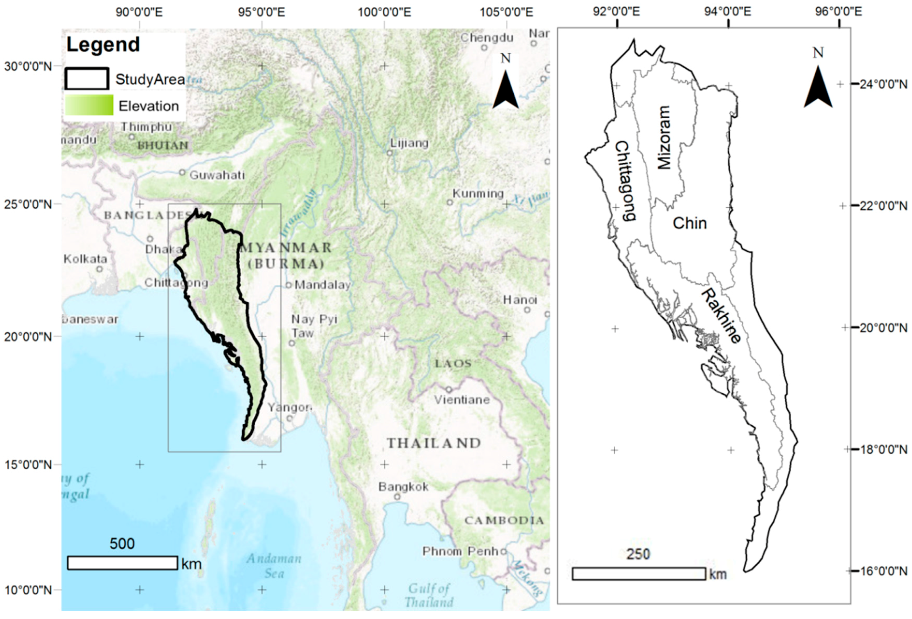
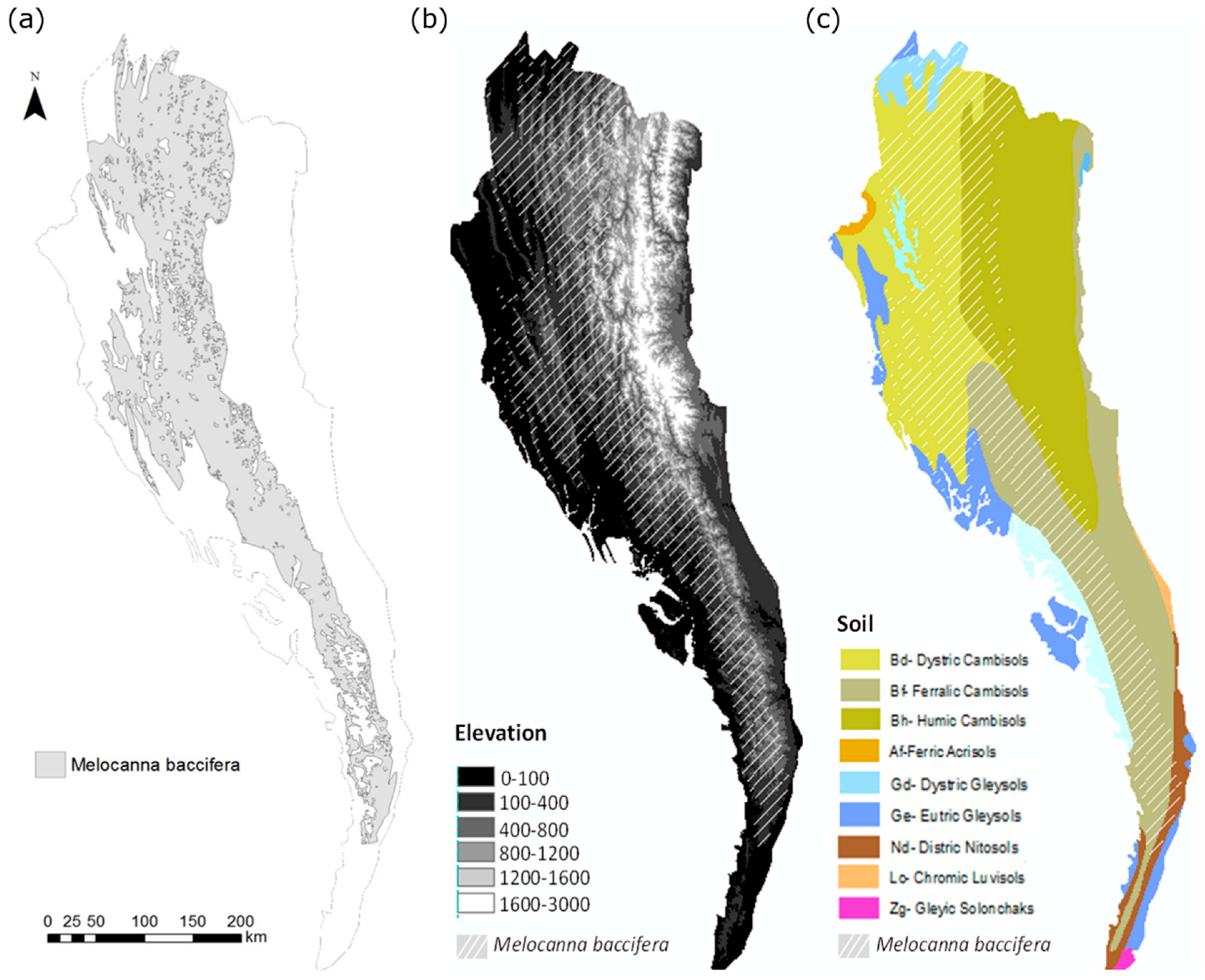
2.1. Study Area and Field Survey

The study area is located in the Arakan mountain range, which spans for about 1000 km parallel to the eastern edge of the Bengali gulf from Cape Negrais, west of the Irrawaddy Delta, and the southern Manipur State of India, touching Myanmar (Rakhine and Chin), Bangladesh (Chittagong), and India (Mizoram and Manipur) (Figure 1). Geologically, the Arakan mountain region belongs to the northern portion of the Burmese-Java arc of the Himalaian system of folding, and it is characterized by Cretaceous-Tertiary flysch sediments with basalt and ultramafic deposits and metamorphic rocks. The terrain of the region is rugged, with steep slopes and elevation reaching over 3000 m (Mt. Victoria). The region is characterized by a tropical monsoon climate, with precipitation concentrated between the months of May and October. The mountains act as a barrier for the southwest monsoon rains, generating a strong rainfall gradient between the western (over 3000 mm) and eastern (1000–3000 mm) slopes. This gradient is also reflected in the vegetation distribution, which shifts from tropical evergreen forest in the west to moist upper deciduous forest in the center and dry deciduous forests in the east. Anthropic activities and intensive agriculture exert strong pressure on the environment, especially on the east side of the region. At the same time, shifting cultivation is common everywhere.
Bamboo species, such as Melocanna baccifera, Bambusa polimorpha, and Bambusa tulda, are widespread in the study area. Bamboo-dominated forests have not been mapped as an independent class in previous land cover maps of the region (e.g., [21,22,23,24,25]), as they are generally included in broader forest cover classes. Although bamboo can be associated with other species in degraded forests or as part of the deciduous and evergreen forest understory, very large and almost pure Melocanna baccifera stands are common in the Arakan Mountains, especially in the southern portion of the area (Chin and Rakhine) [26].
To support satellite image analysis and interpretation, a field survey was carried out in 2013 in Southern Rakhine (i.e., Rakhine Yoma Elephant range) to collect ground information on bamboo-dominated forest areas. The remoteness of the area did not allow a systematic validation study, but qualitative observations along transects crossing the mountain range provided evidence of very large areas dominated by young Melocanna baccifera plants with scattered trees, which could be easily discriminated as an independent vegetation cover class. In addition, in all bamboo-dominated areas that were directly surveyed, the reproductive event was reported and evidence of recent fires was found (i.e., burned bamboo stubbles) below the young bamboo canopy. This was confirmed further by interviews with local farmers, reporting the bamboo reproductive event and subsequent large fires.

2.2. Bamboo Forest Mapping

The identification of forests dominated by Melocanna baccifera, as well as other land cover typologies, has been performed by integrating different cartographic products and satellite imagery. The forest map of South East Asia [21,22], obtained from classification of SPOT VEGETATION images acquired between 1998 and 2000 with 1 km geometric resolution, was used as a reference for the forest type classification of the study area before the bamboo reproductive event. Since the forest map legend includes bamboo forest in a broader class (i.e., “Evergreen wood and shrubland and regrowth mosaics”), the Landsat GEOCOVER mosaic 2000 product [27] was used to refine the bamboo-dominated forest classification by visual interpretation of the mosaic at 1:250,000, exploiting the distinct spectral features of bamboo mature forests [18] (cf. Figure S1). Finally, the potential distribution map of the bamboo species [28,29] was used to define the border for the area dominated by Melocanna baccifera. Overall, four vegetation cover classes were used for the purposes of this study: bamboo-dominated forest, tropical evergreen forest (merging evergreen mountain forests and evergreen lowland forests classes of [22]), deciduous forest (merging deciduous forests and deciduous wood and shrubland and regrowth mosaics of [22]), and crops (other land class of [22]).

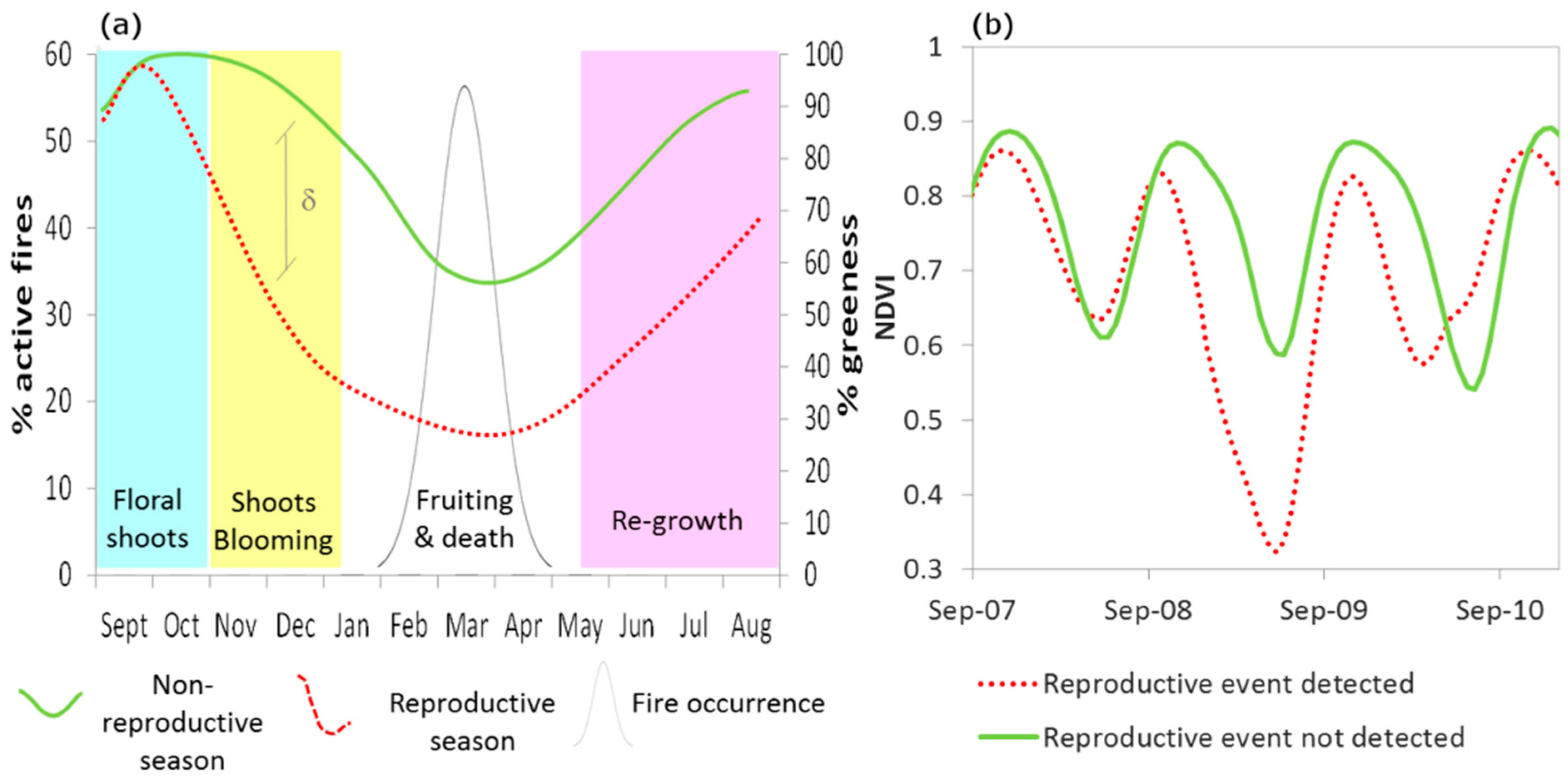
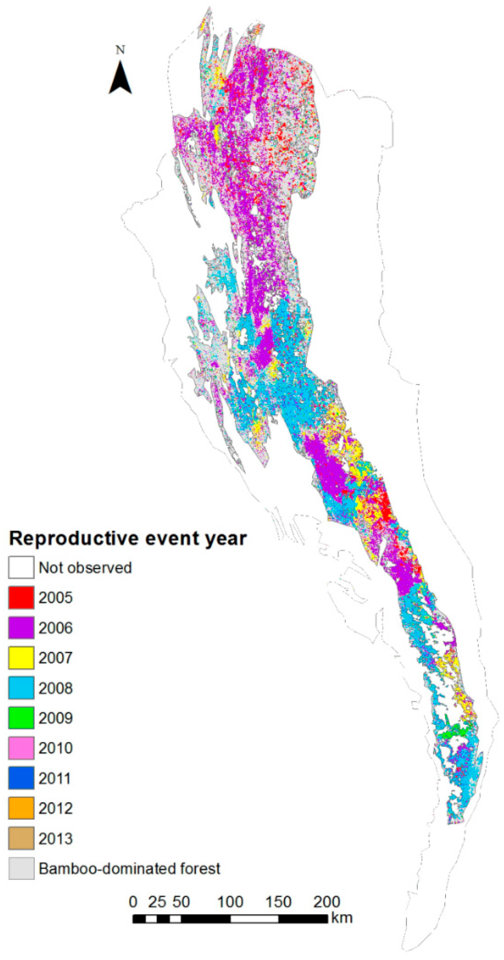
2.3. Bamboo Reproductive Event Detection

Previous studies demonstrated that different bamboo life stages determine clear spectral reflectance variations, which allow their detection from MODIS and LANDSAT TM/ETM multispectral imagery [18]. In this study, MODIS Normalized Difference Vegetation Index (NDVI) images were used to detect the spatial and temporal dynamics of the bamboo reproductive event. Specifically, NDVI time series between 2000 and 2014 generated by the BOKU (University of Natural Resources and Life Sciences, Vienna, Austria) data service platform (http://ivfl-info.boku.ac.at/, accessed on 1 July 2016) [30] were used. Among the options offered by the service, the combined MODIS TERRA/AQUA (MOD13 and MYD13) smoothed NDVI time series with 16-day temporal frequency and 250 m spatial resolution was selected for the study region. For smoothing and gap filling, the BOKU service applies the Whittaker method, deemed accurate and computationally efficient for global-scale NDVI analyses [31,32,33].
Mapping the bamboo reproductive event (i.e., flowering, fruiting, and mortality) was based on the analysis of the phenological behavior of Melocanna baccifera forests during the reproductive season [9] and on the consequent greenness variations. Figure 2 schematically illustrates the expected (Figure 2a) and an example of the observed (Figure 2b) trajectories of greenness/NDVI during a non-reproductive and a reproductive season. In addition, the seasonal frequency distribution of wildfires is shown in Figure 2a. According to this conceptual model and observed NDVI time series, the presence of a significant November/December NDVI negative anomaly, with respect to previous years, was selected as an indicator of the ongoing reproductive event. This is the period when observed anomalies could be clearly associated to the ongoing bamboo reproduction, with minimal expected impact of wildfires on the signal.
Based on this assumption, the following steps were performed on the MODIS NDVI time series to detect the reproductive event:
(i)
Computation of November-December mean NDVI (NDVIND).
(ii)
Starting from the year 2005 (as no bamboo flowering was reported before 2005 [7,8,9], a t-test was applied to identify statistically significant anomalies (p < 0.001) between NDVIND of the year i and mean and standard deviation of NDVIND for the period 2000—year i − 1. These seasons were marked as ‘reproductive seasons’.
As mentioned in Section 2.1, logistic constraints did not allow collection of sufficient ground truth data for a quantitative accuracy assessment of the map at a regional scale. However, to qualitatively check the consistency of the reproductive event map with an independent data source, a dataset of Landsat TM images acquired during the main reproductive years (i.e., 36 cloud-free images, path/row 133/48, 134/46–47, 135/44–45, acquired between November and February from 2005 to 2011) was visually analyzed at 1:300,000 scale, following [18]. Despite the different scale of analysis (i.e., the visual interpretation allow a lower detail in the detection of the reproductive patches), a very good agreement was found in the extent, timing, and spatial patterns of the reproductive event.

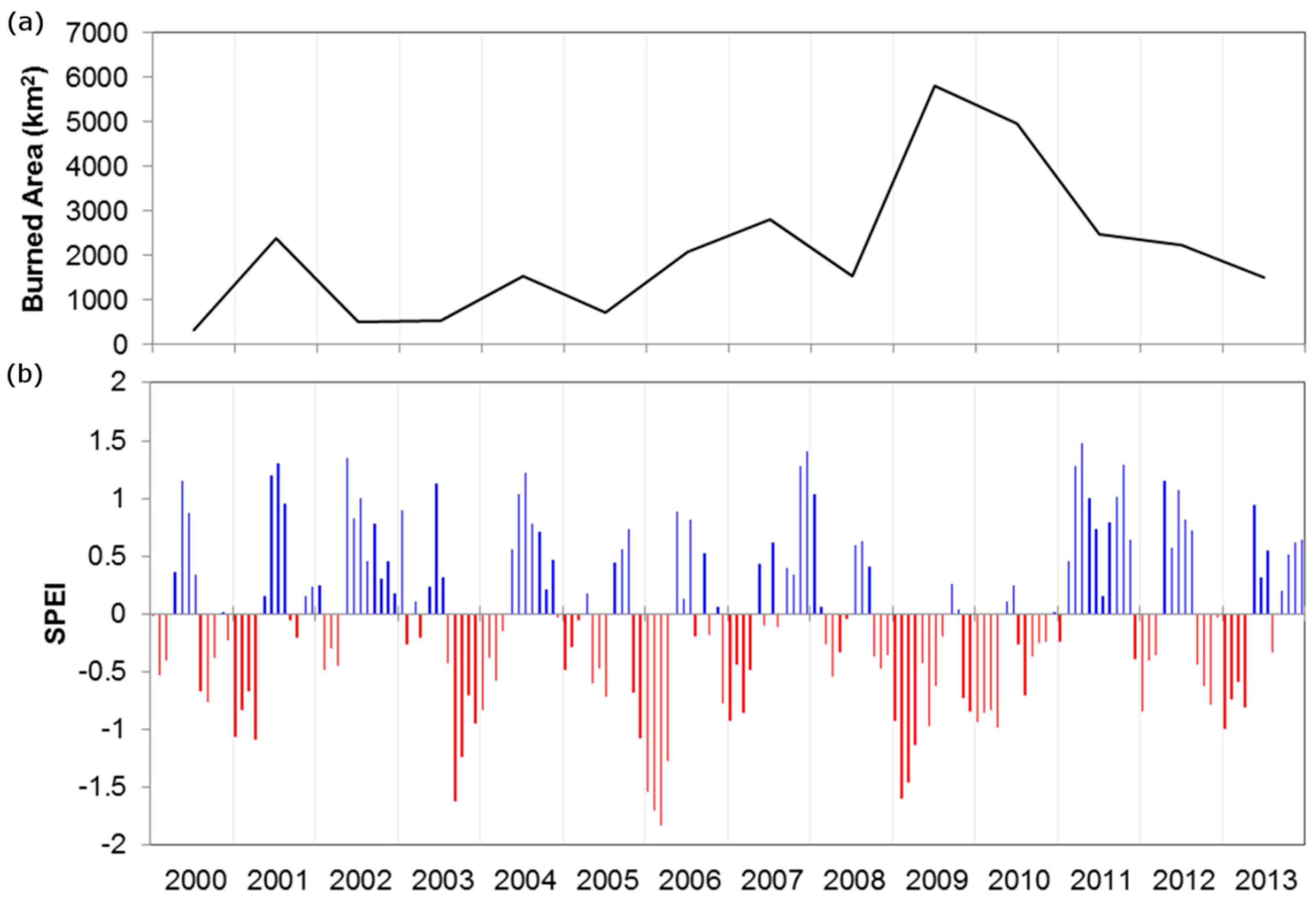
2.4. Evaluation of Wildfire Temporal and Spatial Patterns

To investigate the spatial and temporal dynamics of wildfires before, during, and after the reproductive event, the MODIS burned area (MCD45A1) [34] and active fire [35] products were used. The burned area product provides monthly estimates of area burned at 500 m geometric resolution by identifying rapid changes in daily surface reflectance associated to deposits of charcoal and ash, reduction of vegetation cover, and vegetation structure modification [34]. The full-time series between 2000 and 2014 was analyzed.
The MODIS active fire products (MOD14 and MYD14) uses middle-infrared and thermal bands to detect changes in brightness temperature associated with fire presence [35] at daily time intervals and 1 km spatial resolution. Specifically, in this study, the global fire location product (MCD14ML) in vector format was used to gather information on fire frequency and to provide further support to results provided by the burned area product.
For the analysis of burned area patterns across different land covers, the generated land cover raster layers were first converted to vector format and then overlaid to the MODIS burned area image time series for spatial statistics’ computation. A similar approach was used for the active fire products, but the latter being in vector format, the analysis was performed by selecting data point subsets based on the spatial location and ‘year/month’ attributes. The different spatial resolutions of the data products used (i.e., from 250 m to 1 km) did not represent a major constraint for this analysis, as the size of the reproductive event and burned area patches was much larger than the data spatial resolution.

3. Results and Discussion

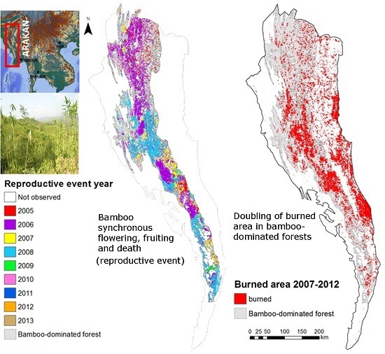
3.1. Bamboo Forest Extent and Reproductive Event Dynamics

The use of multiple imaging products and of the Melocanna baccifera potential distribution map allows for identification of the bamboo-dominated forest’s areal extent. According to this classification, bamboo forests cover approximately 63,000 km2 in the Arakan mountain range (Figure 3a). The central and southern parts of the region, which are mainly composed of Rakhine and Chin, are characterized by large continuous bamboo-dominated forests locally alternated with dense evergreen forest patches and shifting cultivations. The northern part of the region, located in Chittagong and Manipur, is more fragmented, especially in the northeastern portion. Bamboo forests are mainly located on the western slopes of the mountain range, at elevations ranging approximately from 50 to 1050 m a.s.l. (Figure 3b). This is the wetter side of the range due to the orographic effect, with rainfall ranging from 2000 to over 4000 mm per year [36,37]. The entire region is characterized by Cambisols: Dystric Cambisols in the Chittagong Hill region and Western Mizoram, Humic Cambisols in Easter Mizoram and Chin, and Ferralic Cambisols in Rakhine [38] (Figure 3c). These soils are moderately fertile, but they are also prone to severe soil erosion, especially when located over steep slopes [39].
The spatial and temporal patterns of the reproductive event, as derived from the MODIS NDVI analysis, are reported in Figure 4. First detectable flowering episodes occurred in 2005 in the northeast corner of Manipur and in northern Rakhine. Then, between 2006 and 2009, widespread flowering took place all over the region. In 2010 and 2011 the last large bamboo patches flowered in the southernmost portion of Arakan, mainly in Rakhine. Over these years, the large scale reproductive event affected about 65% of the mapped bamboo area. These patterns are fully consistent with the ones evidenced by local scale studies, which mainly focused on rodent outbreaks, reporting general information about bamboo flowering in different areas [9]. The main region where there is no evidence of the occurrence of the bamboo reproductive event is located in the northeastern portion of the study region. In this area, the bamboo-dominated forest is more fragmented and may include different vegetation types affecting the NDVI seasonal trajectory and hampering the detection of the event.
Reproductive events occurred synchronously (i.e., during the same season) over rather homogeneous patches (Figure 4). Patch size was highly variable across the region and shows a power-law distribution (cf. Figure S3). A few large patches (i.e., over 100 km2) represent over 60% of the area, and the largest patch reaches over 3000 km2. The borders among adjacent patches were generally sharp and well defined, similar to the results reported by [18], suggesting that populations may be spatially exclusive. The spatial distribution of the reproductive event patches across elevation does not show any regular temporal pattern (cf. Figure S4). Nevertheless, on average, 60% of patches flowered in contiguous years, suggesting the possibility of a non-random distribution [18]. Although the methodology applied in this study is not intended to map single bamboo populations, but only the regional spatial patterns of the reproductive event, these results seems consistent with the flowering wave hypothesis [40] to explain bamboo’s gregarious flowering spatial and temporal dynamics over large regions. Nevertheless, the event did not show any clear unidirectional spreading dynamic, but followed more complex spatial patterns [18,40].

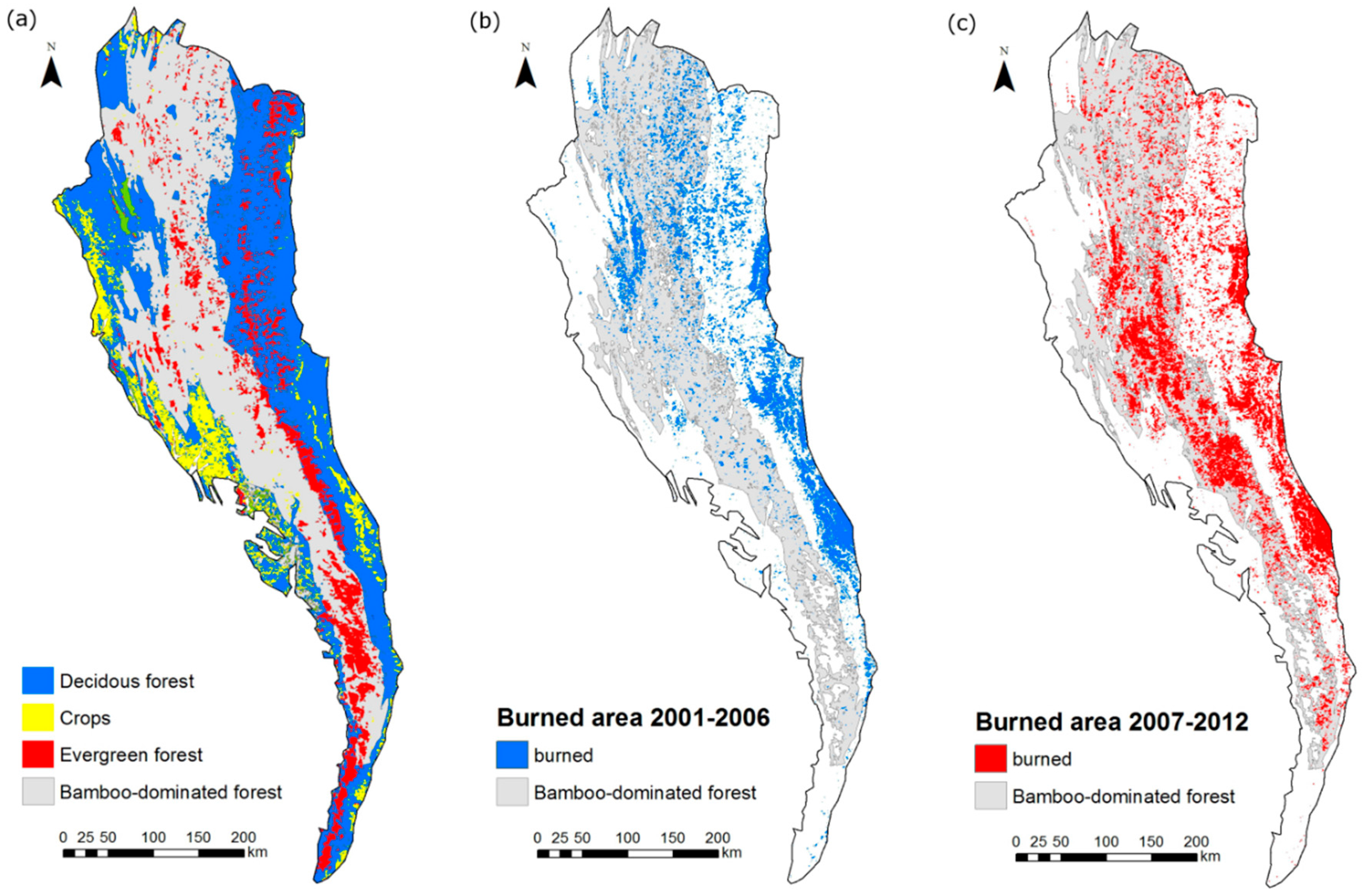
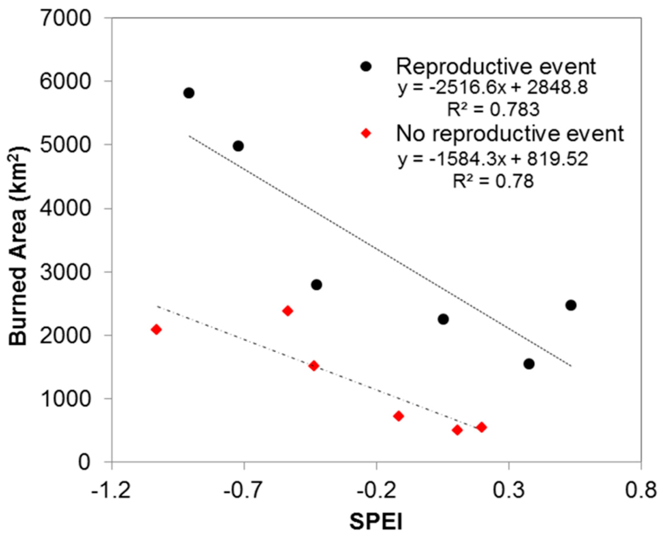
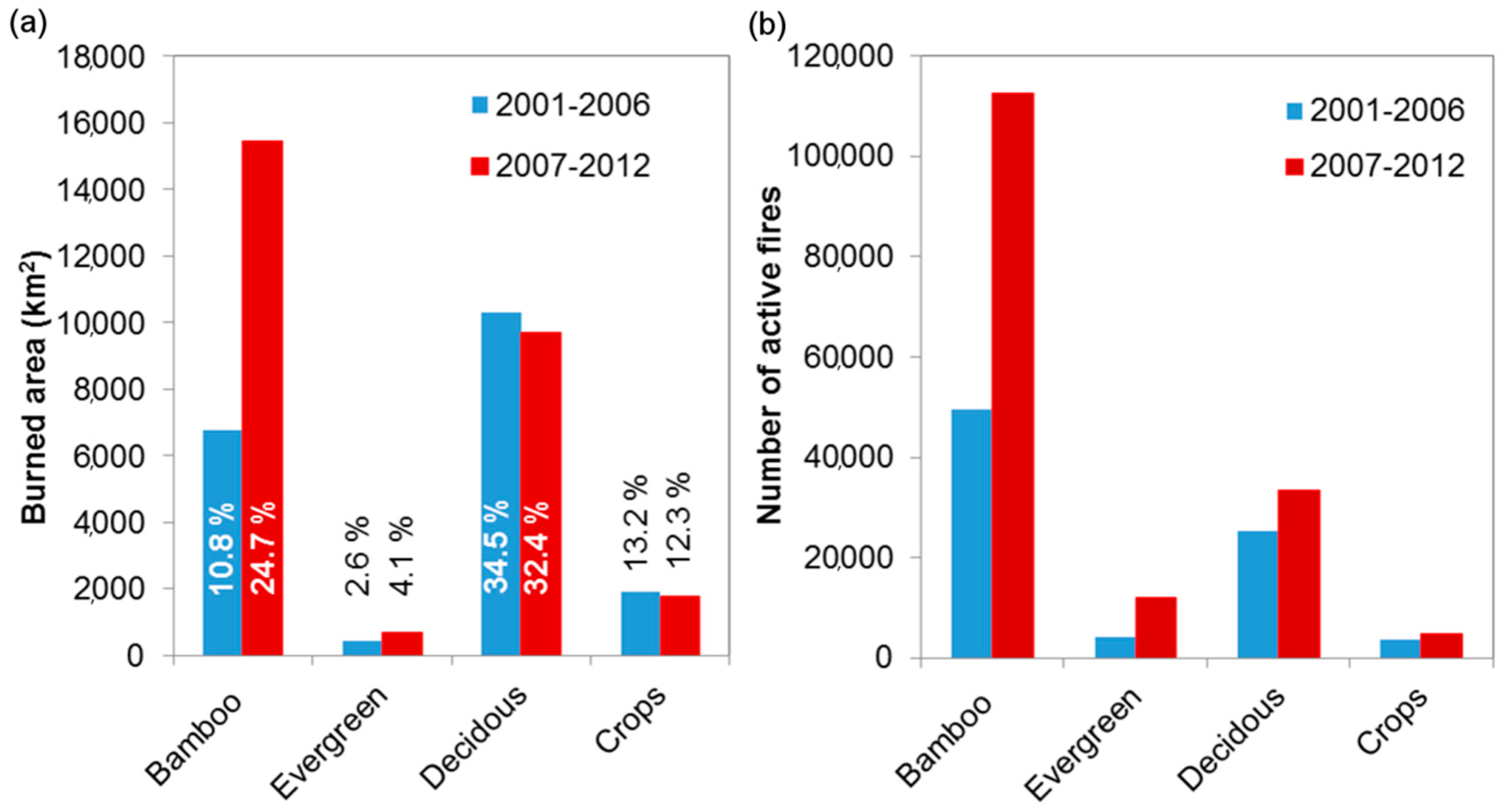
3.2. Analysis of Wildfire Dynamics

The total burned area before and during the reproductive event is reported in Figure 5. Overall, the total burned area almost doubled during the years 2007–2011 (i.e., following the main reproductive event periods, which mainly occurred from late 2006 to 2011) compared to previous years (2001–2006), with total burned area reaching almost 16,000 km2 (i.e., 25% of the total bamboo forest cover).
The analysis of the inter-annual dynamics of burned area in bamboo-dominated forests confirms that a strong increase in burned area took place concurrently with the reproductive event period, with peaks in 2009 and 2010 (Figure 6a). From 2011 onward, yearly burned area gradually decreased to values comparable to years before the reproductive event. However, increasing burned area during this period might be also the consequence of factors other than the reproductive event, primarily drought at regional scale. To test this hypothesis, the Standardized Precipitation and Evapotraspiration Index (SPEI) [41] was used to evaluate if major drought episodes occurred concurrently with the burned area increase. SPEI time series averaged over the study area highlighted two drought episodes during the peak years (Figure 6b), suggesting that drought could also have been a key determinant of the burned area increase in the region. Figure 7 shows the relationship between SPEI and burned area before and during the reproductive event period. The two regression models have similar slopes, but during the reproductive years a significantly higher intercept was observed (p < 0.001, cf. Table S1), resulting on average in an over two to three-fold increase in burned area during the event for comparable SPEI values. This indicates a strong effect of the reproductive event on wildfires dynamics and supports the hypothesis that the massive fuel load generated by the reproductive event created the conditions for large wildfires’ occurrence and propagation.
Figure 8 reports the burned area and the number of active fires for different land covers before and during the reproductive event. It is worth noting that the number of active fires and the burned area only moderately increased in both crop and deciduous forest, further supporting the specificity of the result obtained for bamboo-dominated forests. However, a relevant increase of burned area was detected also within the evergreen forest class (from 2.6% to 4.1% of the total evergreen forest area). Evergreen forest patches are often located within or adjacent to the bamboo-dominated area, suggesting a possible indirect connection with the reproductive event. This hypothesis was tested by calculating the relative contribution to the increase of burned area of evergreen forest patches sharing (EGs) and not-sharing (EGns) a border with bamboo-dominated forest. Burned area within EG patches increased from 125 to 369 km2 (+195%) during reproductive years, while only a limited increase from 313 km2 to 320 km2 (+2.4%) occurred for EGns during the same period. These patterns clearly show a side effect of the reproductive event on the last remaining dense evergreen forest stands of the region.
A close examination of the spatial patterns of burned areas in bamboo-dominated forests at the regional scale shows evidence that increases in burned area are not ubiquitous (Figure 5): a strong increase was mainly observed in the bamboo-dominated forest of Chin and Rakhine. These areas were mostly unaffected by large size wildfires before the bamboo reproductive event. However, similar patterns were not evident in Manipur and Chittagong Hills, which are characterized by more fragmented bamboo cover and higher fire occurrence before the event, often associated with shifting cultivations. Two hypotheses could explain this result. First, the larger pure bamboo forest patches, which characterize Chin and Rakhine, favored ignition and propagation of very large wildfires, while the more fragmented landscapes of Mizoram and Chittagong limited the fire propagation. Second, both India and Bangladesh may have been successful in implementing policy plans to manage the forecasted bamboo reproductive event and related food security crisis, including fire management and suppression [42,43].
Overall, these results provide evidence that the regional scale bamboo mortality promoted the occurrence of large wildfires in the area, with potentially strong ecological impacts over the region other than rodent outbreaks, such as damage to human settlements; fire emissions; disturbance to high conservation value ecosystems, including remnant patches of dense evergreen forests; and direct or indirect impacts on fauna resident of bamboo-dominated habitats. So far, several studies have highlighted that wildfires could facilitate bamboo invasion [12,17], but none have evidenced an interconnection between bamboo reproduction and wildfires at regional scale.
In addition, these analyses provide some level of support to the fire-cycle hypothesis [11], as a clear change in fire regime was associated with the flowering event, especially in regions with large bamboo forest patches where natural fire propagation dynamics can develop [44], including protected areas. Nevertheless, other evidence, such as testing for charcoal in soil profiles and colluvial sediments, should be collected to verify if similar fire dynamics occurred during past reproductive events, and to fully understand if fires effectively could be key determinants of a competitive advantage for bamboo [45].

3.3. Possible Limitations of the Proposed Approach

The assessment of the bamboo forest’s extension is based on the analysis of different mapping products and visual interpretation of the Landsat GeoCover mosaic. Although the reflectance signature of bamboo has distinct features compared to other vegetation typologies and other recent studies successfully used this approach for bamboo forest classification [17,18], more complex approaches might be required to identify understory bamboos or bamboo forest patches within mixed forest areas in fragmented landscapes [46]. However, in the Arakan region Melocanna baccifera generally forms large and nearly pure stands [44], which makes its identification easier and the expected accuracy compatible with a regional scale analysis.
Similar arguments are used to support the validity of the methodological approach used on MODIS NDVI time series for identifying the reproductive event timing and spatial dynamics. The large extension of the bamboo-dominated forest and the consistent spatial patterns of NDVI change during the expected reproductive years allowed us to simplify and make more objective the otherwise extremely time consuming process of visual image interpretation, throughout the automatic identification of the bamboo reproductive event patterns.. Nonetheless, it should be noted that the proposed approach is designed for regional level analysis and it is based on empirical observations and assumptions which are valid only for the specific geographic and ecological context. As such, it should be tested with caution in different geographic areas and/or with other bamboo species and/or for more fragmented landscapes or mixed forests.
A dramatic increase in the burned area and fire frequency was observed during the years of the bamboo reproductive event, with matching spatial and temporal patterns between wildfires and bamboo reproduction dynamics. This finding evidences that the increase of standing dead biomass due to bamboo synchronous mortality favored fire propagation also in areas where large size fires were not common, with potentially relevant environmental impacts. Nothing, however, could be said about the anthropic or natural origin of wildfires and fire ignition processes. Non-scientific reports and interviews with local farmers during the field survey indicated fire as a strategy to control rodent outbreaks during the bamboo reproductive event. However, the extent of this practice is unknown and the vastness of the burned patches in a single season suggests uncontrolled fire propagation, at least in regions such as Chin and Rakhine. This remains an open question to be clarified in order to fully understand the ecology of this event, as well as to support future policy planning to reduce food and environmental insecurity in the area.
Despite the above-mentioned potential sources of inaccuracy recommending caution in the interpretation of the final mapping products, especially for local scale analyses, this study demonstrates consistent spatial and temporal patterns in different satellite data products (i.e., Landsat TM/ETM+, MODIS NDVI, MODIS Burned Area, and MODIS Active Fire), all supporting the large extension of the bamboo reproductive event and a clear change in wildfire regime, and provides the first regional scale assessment for future land policy planning.

4. Conclusions

This study generated the first map of bamboo-dominated forest and describes, for the first time, the spatial and temporal dynamics of the 2005–2011 bamboo reproductive event that occurred in the Arakan mountain range. The results provide evidence of a clear connection between flowering, fruiting, and mortality of the bamboo species Melocanna baccifera and a strong increase in fire occurrence and burned area extent after the reproductive event, offering, to some extent, empirical support to the fire-cycle hypothesis about the bamboo reproductive strategy of mast flowering and semelparity.
The steady increase of burned area during the reproductive event, particularly in Myanmar, suggests that wildfires could have represented a major factor of environmental and food insecurity for local communities in the region, together with the widely reported rodent outbreaks. It also marks a potential threat for the conservation of important ecosystems, such as the remaining evergreen forest patches.
These results emphasize the regional relevance of this pulse event, calling for integrated and coordinated management strategies between the involved states, international institutions, and non-governmental organizations. The generated mapping products of bamboo forest extension and reproductive event dynamics may offer a baseline for supporting a better understanding of bamboo ecology in the region, as well as for planning mitigation strategies to reduce the impact of the next reproductive event.
Finally, this study also highlights the potential role and impact of pulse ecological events in South East Asia, especially in the framework of monitoring and assessment studies based on Earth observation data. The rapidness, relevance, and significant impacts of this event suggests the need for using multiple-scale satellite data products in order to detect rapid landscape changes, as well as the importance of a better understanding of forest ecology dynamics at a sub-continent scale.

Supplementary Materials

The following are available online at www.mdpi.com/2072-4292/9/1/85/s1, Figure S1: Bamboo-dominated forest map; Figure S2: Z-score NDVI time series; Figure S3: Patch-size distribution; Figure S4: Patch elevation distribution; Table S1: Burned area vs. SPEI relationship.

Acknowledgments

This study was funded by Istituto Oikos Onlus (Italy). We are extremely grateful to the Myanmar team of Istituto Oikos, and, in particular, to Milo Todeschini, Lara Beffasti, U Aye Cho, and Maung Maung Pyone for their support during the field survey in Myanmar. We also wish to thank Nathaniel Jensen, Rupsha Banerjee, and the anonymous reviewers for the useful comments and suggestions.

Author Contributions

The general conception of the study was shared between Francesco Fava and Roberto Colombo. Both authors also participated to fieldwork activities. Data processing and analyses have been mainly done by Francesco Fava. Both authors contributed to the paper writing. Overall, authors contributed equally to this study.

Conflicts of Interest

The authors declare no conflict of interest.

References

  1. Yang, L.H.; Edwards, K.F.; Byrnes, J.E.; Bastow, J.L.; Wright, A.N.; Spence, K.O. A meta-analysis of resource pulse–consumer interactions. Ecol. Monogr. 2010, 80, 125–151. [Google Scholar] [CrossRef]
  2. Yang, L.H.; Bastow, J.L.; Spence, K.O.; Wright, A.N. What can we learn from resource pulses? Ecology 2008, 89, 621–634. [Google Scholar] [CrossRef] [PubMed]
  3. Silvertown, J.W. The evolutionary ecology of mast seeding trees. Biol. J. Linn. Soc. 1980, 14, 235–250. [Google Scholar] [CrossRef]
  4. Soderstrom, T.R.; Calderon, C.E. A commentary on the bamboos (Poaceae: Bambusoideae). Biotropica 1979, 11, 161–172. [Google Scholar] [CrossRef]
  5. Janzen, D.H. Why bamboos wait so long to flower? Annu. Rev. Ecol. Syst. 1976, 7, 347–391. [Google Scholar] [CrossRef]
  6. Blatter, E. The flowering of bamboos. J. Bombay Nat. Hist. Soc. 1930, 34, 135–141. [Google Scholar]
  7. Normile, D. Holding back a torrent of rats. Science 2010, 327, 806–807. [Google Scholar] [CrossRef] [PubMed]
  8. Singleton, G.R.; Belmain, S.; Brown, P.R.; Aplin, K.; Htwe, N.M. Impacts of rodent outbreaks on food security in Asia. Wildlife Res. 2010, 37, 355–359. [Google Scholar] [CrossRef]
  9. Singleton, G.R. Rodent Outbreaks: Ecology and Impacts; International Rice Research Institute: Los Banos, Philippines, 2010. [Google Scholar]
  10. Rao, M.; Htun, S.; Platt, S.G.; Tizard, R.; Poole, C.; Myint, T.; Watson, J.E.M. Biodiversity conservation in a changing climate: A review of threats and implications for conservation planning in Myanmar. AMBIO 2013, 42, 789–804. [Google Scholar] [CrossRef] [PubMed]
  11. Keeley, J.E.; Bond, W.J. Mast flowering and semelparity in bamboos: The bamboo fire cycle hypothesis. Am. Nat. 1999, 154, 383–391. [Google Scholar] [CrossRef] [PubMed]
  12. Smith, M.; Nelson, B.W. Fire favours expansion of bamboo-dominated forests in the south-west Amazon. J. Trop. Ecol. 2011, 27, 59–64. [Google Scholar] [CrossRef]
  13. Saha, S.; Howe, H.F. The bamboo fire cycle hypothesis: A comment. Am. Nat. 2001, 158, 659–663. [Google Scholar] [CrossRef] [PubMed]
  14. Keeley, J.E.; Bond, W.J. On incorporating fire into our thinking about natural ecosystems: A response to Saha and Howe. Am. Nat. 2001, 158, 664–670. [Google Scholar] [CrossRef] [PubMed]
  15. Barlow, J.; Silveira, J.M.; Mestre, L.A.; Andrade, R.B.; D’Andrea, G.C.; Louzada, J.; Vaz-de-Mello, F.Z.; Numata, I.; Lacau, S.; Cochrane, M.A. Wildfires in bamboo-dominated Amazonian forest: Impacts on above-ground biomass and biodiversity. PLoS ONE 2012, 7, e33373. [Google Scholar] [CrossRef]
  16. Franklin, D.C.; Prior, L.D.; Hogarth, N.J.; McMahon, C.R. Bamboo, fire and flood: Consequences of disturbance for the vegetative growth of a clumping, clonal plant. Plant Ecol. 2010, 208, 319–332. [Google Scholar] [CrossRef]
  17. McMichael, C.H.; Bush, M.B.; Silman, M.R.; Piperno, D.R.; Raczka, M.; Lobato, L.C.; Zimmerman, M.; Hagen, S.; Palace, M. Historical fire and bamboo dynamics in western Amazonia. J. Biogeogr. 2013, 40, 299–309. [Google Scholar] [CrossRef]
  18. De Carvalho, A.L.; Nelson, B.W.; Bianchini, M.C.; Plagnol, D.; Kuplich, T.M.; Daly, D.C. Bamboo-dominated forests of the southwest Amazon: Detection, spatial extent, life cycle length and flowering waves. PLoS ONE 2013, 8, e54852. [Google Scholar] [CrossRef] [PubMed]
  19. Mouillot, F.; Schultz, M.G.; Yue, C.; Cadule, P.; Tansey, K.; Ciais, P.; Chuvieco, E. Ten years of global burned area products from spaceborne remote sensing—A review: Analysis of user needs and recommendations for future developments. Int. J. Appl. Earth Obs. 2014, 26, 64–79. [Google Scholar] [CrossRef]
  20. Giglio, L.; Loboda, T.; Roy, D.P.; Quayle, B.; Justice, C.O. An active-fire based burned area mapping algorithm for the MODIS sensor. Remote Sens. Environ. 2009, 113, 408–420. [Google Scholar] [CrossRef]
  21. Stibig, H.J.; Achard, F.; Fritz, S. A new forest cover map of continental Southeast Asia derived from SPOT-VEGETATION satellite imagery. Appl. Veg. Sci. 2004, 7, 153–162. [Google Scholar] [CrossRef]
  22. Stibig, H.J.; Belward, A.S.; Roy, P.S.; Rosalina-Wasrin, U.; Agrawal, S.; Joshi, P.K.; Beuchle, R.; Fritz, S.; Mubareka, S.; Giri, C. A land-cover map for South and Southeast Asia derived from SPOT-VEGETATION data. J. Biogeogr. 2007, 34, 625–637. [Google Scholar] [CrossRef]
  23. Giri, C.; Defourny, P.; Shrestha, S. Land cover characterization and mapping of continental Southeast Asia using multi-resolution satellite sensor data. Int. J. Remote Sens. 2003, 24, 4181–4196. [Google Scholar] [CrossRef]
  24. Food and Agriculture Organization. Global Forest Resources Assessment 2015. Available online: http://www.fao.org/forest-resources-assessment/en/ (accessed on 20 July 2016).
  25. Giri, C.; Pradhan, D.; Ofren, R.S.; Kratzschmar, E. Land Use/Land Cover Change in South and South-East Asia; UNEP Environment Assessment Programme for Asia and the Pacific: Bangkok, Thailand, 1998. [Google Scholar]
  26. Rao, A.N.; Ramanatha Rao, V. Bamboo-Conservation, diversity, ecogeography, germplasm, resource utilization and taxonomy. In Proceedings of the Training Course Cum Workshop, Kunming and Xishuanbanna, Yunnan, China, 10–17 May 1998.
  27. Landsat Orthorectified Dataset (January 2005–December 2011). The Global Land Cover Facility 2005. Available online: http://www.glovis.org (accessed on 31 December 2015).
  28. Bystriakova, N.; Kapos, V.; Stapleton, C.M.A.; Lysenko, I. Bamboo Biodiversity; UNEP-WCMC: Cambridge, UK, 2003. [Google Scholar]
  29. Bystriakova, N.; Kapos, V.; Lysenko, I.; Stapleton, C.M.A. Distribution and conservation status of forest bamboo biodiversity in the Asia-Pacific Region. Biodivers. Conserv. 2003, 12, 1833–1841. [Google Scholar] [CrossRef]
  30. Vuolo, F.; Mattiuzzi, M.; Klisch, A.; Atzberger, C. Data service platform for MODIS vegetation indices time series processing at BOKU Vienna: Current status and future perspectives. Proc. SPIE 2012. [Google Scholar] [CrossRef]
  31. Atzberger, C.; Eilers, P.H.C. Evaluating the effectiveness of smoothing algorithms in the absence of ground reference measurements. Int. J. Remote Sens. 2011, 32, 3689–3709. [Google Scholar] [CrossRef]
  32. Atkinson, P.M.; Jeganathan, C.; Dash, J.; Atzberger, C. Intercomparison of four models for smoothing satellite sensor time-series data to estimate vegetation phenology. Remote Sens. Environ. 2012, 123, 400–417. [Google Scholar] [CrossRef]
  33. Eilers, P.H.C. A perfect smoother. Anal. Chem. 2003, 75, 3631–3636. [Google Scholar] [CrossRef] [PubMed]
  34. Roy, D.P.; Jin, Y.; Lewis, P.E.; Justice, C.O. Prototyping a global algorithm for systematic fire-affected area mapping using MODIS time series data. Remote Sens. Environ. 2005, 97, 137–162. [Google Scholar] [CrossRef]
  35. Giglio, L.; Descloitres, J.; Justice, C.O.; Kaufman, Y.J. An enhanced contextual fire detection algorithm for MODIS. Remote Sens. Environ. 2003, 87, 273–282. [Google Scholar] [CrossRef]
  36. FAO. Agricultural Atlas of the Union of Myanmar-Agricultural Year 2001–2002. Available online: http://dwms.fao.org/atlases/myanmar/index_en.htm (accessed on 20 July 2016).
  37. Attri, S.D.; Tyagi, A. Climate profile of India. Met. Monogr. Environ. Meteorol. 2010, 1, 1–122. [Google Scholar]
  38. FAO. Digital Soil Map of the World 2007. Available online: http://www.fao.org/geonetwork/srv/en/metadata.show?id=14116 (accessed on 10 July 2016).
  39. Dudal, R. Soils of Southeast Asia. In The Physical Geography of Southeast Asia, 1st ed.; Gupta, A., Ed.; Oxford University Press: Oxford, UK, 2005; pp. 94–104. [Google Scholar]
  40. Franklin, D.C. Synchrony and asynchrony: Observations and hypotheses for the flowering wave in a long-lived semelparous bamboo. J. Biogeogr. 2004, 31, 773–786. [Google Scholar] [CrossRef]
  41. Vicente-Serrano, S.M.; Beguería, S.; López-Moreno, J.I. A multi-scalar drought index sensitive to global warming: The standardized precipitation evapotranspiration index. J. Clim. 2010, 23, 1696–1718. [Google Scholar] [CrossRef]
  42. Planning & Programme Implementation Department, Government of Mizoram. Government of Mizoram Comprehensive Action Plan for Bamboo Flowering and Famine Combat Schemes (BAFFACOS) (2004–2005 to 2008–2009). Available online: http://mizoram.nic.in/dept/planning/baffacos.htm (accessed on 20 July 2016).
  43. United Nations Development Program, Bangladesh. Scientific Report on Bamboo Flowering, Rodent Outbreaks and Food Security: Rodent Ecology, Pest Management, and Socio-Economic Impact in the Chittagong Hill Tracts. 2008. Available online: http://projects.nri.org/bandicoot/docs/bamboo.pdf (accessed on 20 July 2016).
  44. Platt, S.G.; Ko, W.K.; Myo, K.M.; Khaing, L.L.; Platt, K.; Maung, A.; Rainwater, T.R. Notes on Melocanna baccifera and bamboo brakes in the Rakhine hills of western Myanmar. Bamboo Sci. Cult. 2010, 23, 1–12. [Google Scholar]
  45. Rayle, C.M.; Franklin, S.B.; Lu, Z. Fire occurrence in relation to bamboo dominance in the Qinling Mountains of China: Evidence from phytolith and charcoal records in Holocene sediments. Sci. China Earth Sci. 2015, 58, 1182–1190. [Google Scholar] [CrossRef]
  46. Linderman, M.; Liu, J.; Qi, J.; An, L.; Ouyang, Z.; Yang, J.; Tan, Y. Using artificial neural networks to map the spatial distribution of understorey bamboo from remote sensing data. Int. J. Remote Sens. 2004, 25, 1685–1700. [Google Scholar] [CrossRef]
Figure 1. Study area. On the left, the study area border is evidenced on the mainland South East Asia topographic map. On the right, the main administrative regions included in the study area are reported (i.e., Rakhine and Chin-Myanmar, Chittagong-Bangladesh, Mizoram-India).
Remotesensing 09 00085 g001
Figure 2. (a) Conceptual model of the expected variations in greenness during reproductive and non-reproductive seasons. Wildfire monthly frequency distribution assessed from the active fire MODIS product over the study area (see next paragraph) is also reported. δ indicates the expected November/December difference in NDVI during the reproductive season, the indicator used to detect the event; (b) Examples of MODIS NDVI time series of bamboo-dominated forests in the case of detected (red) and not detected (green) reproductive events. In the example, the detected reproductive event occurred in late 2008/beginning 2009.
Remotesensing 09 00085 g002
Figure 3. Distribution of Melocanna baccifera (a) superimposed (white stripes) to the elevation map (b) and the soil map (c) of the study region.
Remotesensing 09 00085 g003
Figure 4. Map of the estimated year of occurrence of the bamboo reproductive event. For the main reproductive seasons (i.e., 2006–2010) the NDVIND temporal trend is reported in Figure S2.
Remotesensing 09 00085 g004
Figure 5. (a) Main land covers of the study area; (b) total burned area before (2000–2006); and (c) during (2006–2012) the bamboo reproductive event.
Remotesensing 09 00085 g005
Figure 6. (a) 2000–2013 time series of burned area in bamboo-dominated forests; and (b) of Standardized Precipitation and Evapotraspiration Index (SPEI) (three-month timescale) averaged over the study area. Blue columns evidence positive SPEI values, red columns negative SPEI values.
Remotesensing 09 00085 g006
Figure 7. Ordinary Regression models between mean November-May SPEI (i.e., dry season SPEI) and Burned Area before the reproductive event (2001–2006) and during the reproductive event (2007–2012).
Remotesensing 09 00085 g007
Figure 8. (a) Burned area before and during the reproductive event. The burned area percent with respect to the total cover is also reported; (b) Number of active fires detected before and during the reproductive event.
Remotesensing 09 00085 g008

