Precise Orbit Determination of BeiDou Satellites with Contributions from Chinese National Continuous Operating Reference Stations

 ,
,
Abstract
:
1. Introduction
2. Materials and Methods
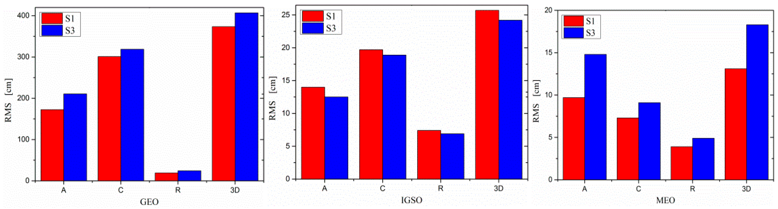
3. Results
3.1. Impact of CNCORS on BDS/GPS Joint POD
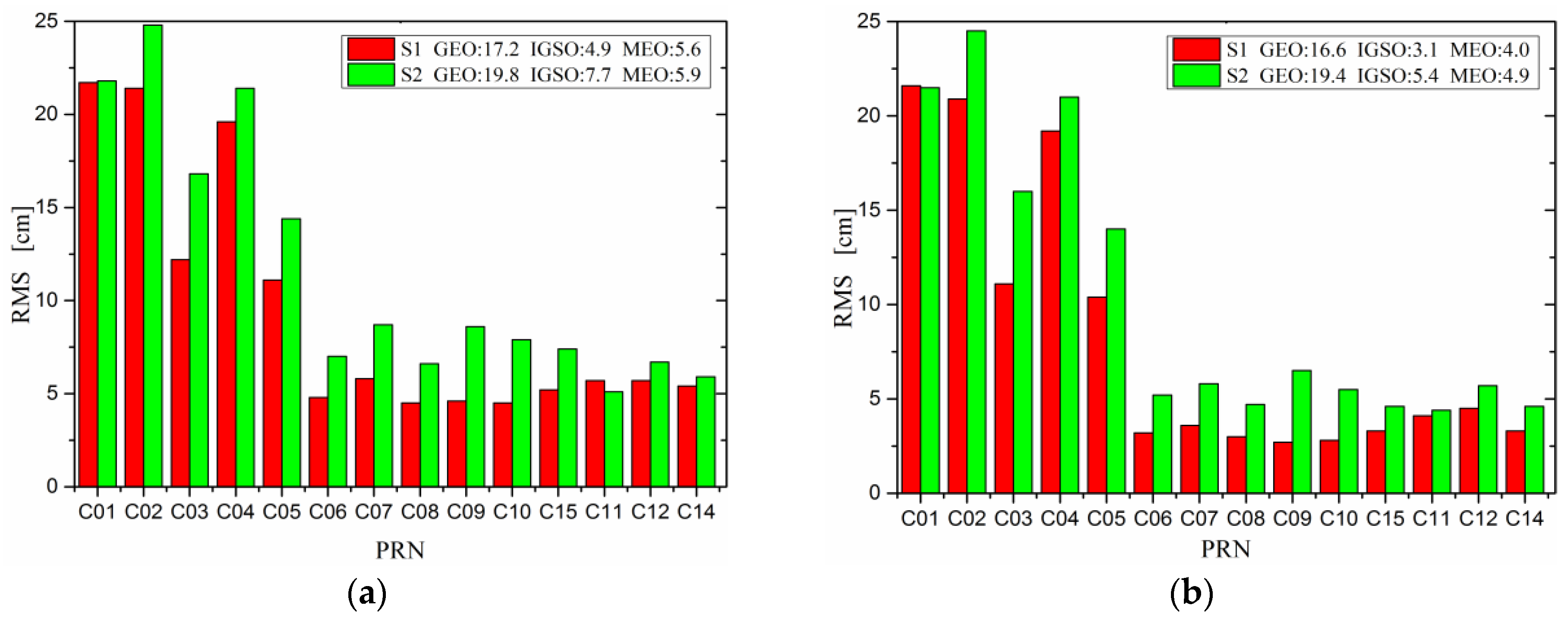
3.1.1. Overlapping Arcs Precision
3.1.2. Comparison with GBM Orbit
3.1.3. SLR Assessment
3.1.4. Orbit Dilution of Precision Analysis
3.2. Impact of CNCORS on BDS Single-System POD
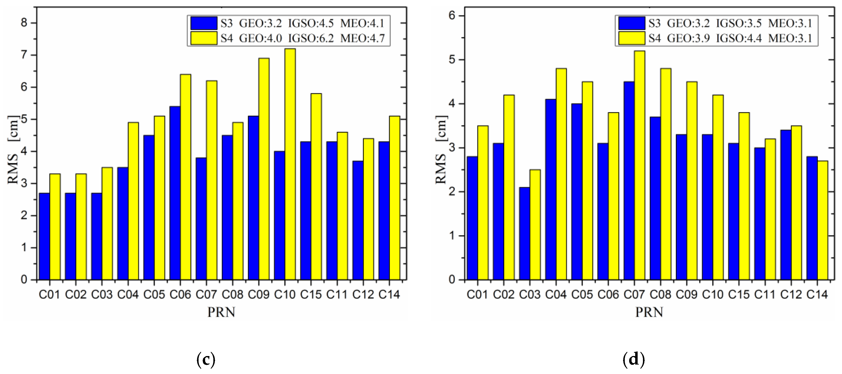
3.2.1. Overlapping Arcs Precision
3.2.2. Comparisons with GBM Orbit
3.2.3. SLR Assessment
3.3. Comparison between BDS Single-System and Joint POD
3.3.1. Overlapping Arcs Precision
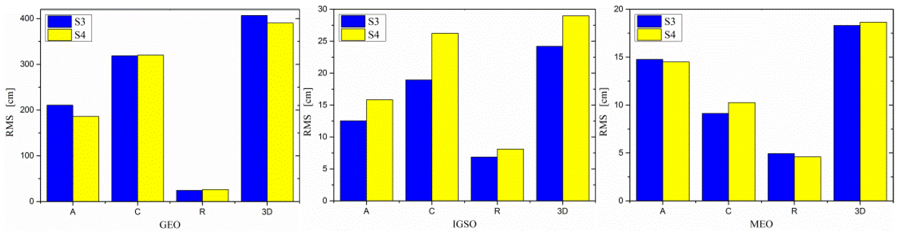
3.3.2. Comparison with GBM Orbit
3.3.3. SLR Assessment
4. Discussion
5. Conclusions
Acknowledgments
Author Contributions
Conflicts of Interest
References
- Yang, Y.X. Progress, contribution and challenges of Compass/Beidou satellite navigation system. Acta Geod. Cartogr. Sin. 2010, 39, 1–6. [Google Scholar]
- Ge, M.R.; Zhang, H.P.; Jia, X.L.; Song, S.L.; Wickert, J. What is achievable with the current compass constellation. GPS World 2012, 11, 29–34. [Google Scholar]
- Shi, C.; Zhao, Q.L.; Li, M.; Tang, W.M.; Hu, Z.G.; Lou, Y.D.; Zhang, H.P.; Niu, X.J.; Liu, J.N. Precise orbit determination of Beidou Satellites with precise positioning. Sci. China Earth Sci. 2012, 55, 1079–1086. [Google Scholar] [CrossRef]
- Montenbruck, O.; Hauschild, A.; Steigenberger, P.; Hugentobler, U.; Teunissen, P.; Nakamura, S. Initial assessment of the COMPASS/BeiDou-2 regional navigation satellite system. GPS Solut. 2013, 17, 211–222. [Google Scholar] [CrossRef]
- Zhao, Q.; Guo, J.; Li, M.; Liu, J.N. Initial results of precise orbit and clock determination for COMPASS navigation satellite system. J. Geod. 2013, 87, 475–486. [Google Scholar] [CrossRef]
- Steigenberger, P.; Hugentobler, U.; Hauschild, A.; Montenbruck, O. Orbit and clock analysis of Compass GEO and IGSO satellites. J. Geod. 2013, 87, 515–525. [Google Scholar] [CrossRef]
- Zhou, S.S.; Hu, X.G.; Zhou, J.H.; Chen, J.P.; Gong, X.; Tang, C.; Wu, B.; Liu, L.; Guo, R.; He, F.; et al. Accuracy analyses of precise orbit determination and timing for COMPASS/Beidou-2 4GEO/5IGSO/4MEO constellation. Lect. Notes Electr. Eng. 2013, 245, 89–102. [Google Scholar] [CrossRef]
- Liu, Y.; Lou, Y.; Shi, C.; Zheng, F.; Yin, Q. BeiDou regional navigation system network solution and precision analysis. Lect. Notes Electr. Eng. 2013, 245, 173–186. [Google Scholar] [CrossRef]
- He, L.N.; Ge, M.R.; Wang, J.X.; Wickert, J.; Schuh, H. Experimental study on the precise orbit determination of the BeiDou navigation satellite system. Sensors 2013, 13, 2911–2928. [Google Scholar] [CrossRef] [PubMed]
- Lou, Y.D.; Liu, Y.; Shi, C.; Yao, X.G.; Zheng, F. Precise orbit determination of BeiDou constellation based on BETS and MGEX network. Sci. Rep. 2014, 4, 4692. [Google Scholar] [CrossRef] [PubMed]
- Lou, Y.D.; Liu, Y.; Shi, C.; Wang, B.; Yao, X.G.; Zheng, F. Precise orbit determination of BeiDou constellation: Method comparison. GPS Solut. 2016, 20, 259–268. [Google Scholar] [CrossRef]
- Zhang, R.; Zhang, Q.; Huang, G.; Wang, L.; Qu, W. Impact of tracking station distribution structure on BeiDou satellite orbit determination. Adv. Space Res. 2015, 56, 2177–2187. [Google Scholar] [CrossRef]
- Deng, Z.; Fritsche, M.; Uhlemann, M.; Wickert, J.; Schuh, H. Reprocessing of GFZ Multi-GNSS product GBM. In Proceedings of the IGS Workshop, Sydney, Australia, 8–12 February 2016. [Google Scholar]
- Liu, J.H.; Gu, D.F.; Ju, B.; Shen, Z.; Lai, Y.W.; Yi, D.Y. A new empirical solar radiation pressure model for BeiDou GEO satellites. Adv. Space Res. 2016, 57, 234–244. [Google Scholar] [CrossRef]
- Tan, B.F.; Yuan, Y.B.; Zhang, B.C.; Hsu, H.Z.; Ou, J.K. A new analytical solar radiation pressure model for current BeiDou satellites: IGGBSPM. Sci. Rep. 2016, 6, 32967. [Google Scholar] [CrossRef] [PubMed]
- Guo, J.; Chen, G.; Zhao, Q.L.; Liu, J.N.; Liu, X.L. Comparison of solar radiation pressure models for BDS IGSO and MEO satellites with emphasis on improving orbit quality. GPS Solut. 2017, 21, 511–522. [Google Scholar] [CrossRef]
- Capuano, V.; Shehaj, E.; Blunt, P.; Botteron, C.; Farine, P.-A. High accuracy GNSS based navigation in GEO. Acta Astronaut. 2017, 136, 332–341. [Google Scholar] [CrossRef]
- Wang, W.; Chen, G.C.; Guo, S.R.; Song, X.Y.; Zhao, Q.L. A study on the Beidou IGSO/MEO satellite orbit determination and prediction of the different yaw control mode. Lect. Notes Electr. Eng. 2013, 245, 31–40. [Google Scholar] [CrossRef]
- Guo, J.; Zhao, Q.L.; Geng, T.; Su, X.; Liu, J.N. Precise orbit determination for COMPASS IGSO satellites during yaw maneuvers. Lect. Notes Electr. Eng. 2013, 245, 41–53. [Google Scholar] [CrossRef]
- Dai, X.L.; Ge, M.R.; Lou, Y.D.; Shi, C.; Wickert, J.; Schuh, H. Estimating the yaw-attitude of BDS IGSO and MEO satellites. J. Geod. 2015, 89, 1005–1018. [Google Scholar] [CrossRef]
- Fan, L.; Jiang, C.; Hu, M. Ground track maintenance for BeiDou IGSO satellites subject to tesseral resonances and the luni-solar perturbations. Adv. Space Res. 2017, 59, 753–761. [Google Scholar] [CrossRef]
- Dilssner, F.; Springer, T.; Schönemann, E.; Enderle, W. Estimation of satellite antenna phase center corrections for BeiDou. In Proceedings of the IGS Workshop, Pasadena, CA, USA, 23–27 June 2014. [Google Scholar]
- Montenbruck, O.; Steigenberger, P.; Prange, L.; Deng, Z.G.; Zhao, Q.L.; Perosanz, F.; Romero, I.; Noll, C.; Stürze, A.; Weber, G.; et al. The Multi-GNSS Experiment (MGEX) of the International GNSS Service (IGS)—Achievements, prospects and challenges. Adv. Space Res. 2017, 59, 1671–1697. [Google Scholar] [CrossRef]
- Chen, J.Y.; Zhang, P.; Wu, J.L.; Zhang, Q.D. On Chinese national continuous operating reference station system of GNSS. Acta Geod. Cartog. Sin. 2007, 36, 366–369. [Google Scholar]
- Liu, J.N.; Ge, M.R. PANDA software and its preliminary result of positioning and orbit determination. Wuhan Univ. J. Nat. Sci. 2003, 8, 603–609. [Google Scholar] [CrossRef]
- Boehm, J.; Heinkelmann, R.; Schuh, H. Short note: A global model of pressure and temperature for geodetic applications. J. Geod. 2007, 81, 679–683. [Google Scholar] [CrossRef]
- Boehm, J.; Niell, A.; Tregoning, P.; Schuh, H. Global Mapping Function (GMF): A new empirical mapping function based on numerical weather model data. Geophys. Res. Lett. 2006, 33. [Google Scholar] [CrossRef]
- Beutler, G.; Bockmann, E.; Gurtner, W.; Huobler, U.; Mervart, L. Extended orbit modeling techniques at the CODE processing center of the International GPS Service for geodynamics (IGS): Theory and initial results. Eur. Respir. J. 1994, 7, 1350–1364. [Google Scholar]
- Wessel, P.; Smith, W.H.F. New, improved version of generic mapping tools released. EOS Trans. AGU 2006, 79, 579. [Google Scholar] [CrossRef]
- Sośnica, K.; Thaller, D.; Dach, R.; Steigenberger, P.; Beutler, G.; Arnold, D.; Jäggi, A. Satellite laser ranging to GPS and GLONASS. J. Geod. 2015, 89, 725–743. [Google Scholar] [CrossRef] [Green Version]
- Pearlman, M.R.; Degnan, J.J.; Bosworth, J.M. The International Laser Ranging Service. Adv. Space Res. 2002, 30, 135–143. [Google Scholar] [CrossRef]
- Phillips, A.H. Geometrical Determination of PDOP. Navigation 1984, 31, 329–337. [Google Scholar] [CrossRef]
- Parkinson, B.W.; Enge, P.; Axelrad, P.; Spilker, J.J., Jr. Global Positioning System: Theory and Applications, Volume II. AIAA 1996, 38, 99–102. [Google Scholar]
- Wen, Y.L.; Liu, Q.X.; Zhu, J.; Liao, Y. The effect of TT&C deployment on the regional satellite navigation system. J. Natl. Univ. Def. Technol. 2007, 1, 1–6. [Google Scholar] [CrossRef]
- Yang, Y.X.; Wen, Y.L. Synthetically Adaptive Robust Filtering for Satellite Orbit Determination. Sci. China Earth Sci. 2004, 47, 585–592. [Google Scholar] [CrossRef]
- Zhang, L.P.; Dang, Y.M.; Xue, S.Q.; Wang, H.; Gu, S.Z.; Wang, C.Y. The Optimal Distribution Strategy of BeiDou Monitoring Stations for GEO Precise Orbit Determination. Lect. Notes Electr. Eng. 2015, 340, 153–161. [Google Scholar]
- Arnold, D.; Meindl, M.; Beutler, G.; Dach, R.; Schaer, S.; Lutz, S.; Prange, L.; Sośnica, K.; Mervart, L.; Jäggi, A. CODE’s new solar radiation pressure model for GNSS orbit determination. J. Geod. 2015, 89, 775–791. [Google Scholar] [CrossRef] [Green Version]
- Zhang, X.H.; He, X.Y. Performance analysis of triple-frequency ambiguity resolution with BeiDou observations. GPS Solut. 2016, 20, 1–13. [Google Scholar] [CrossRef]
- Paziewski, J.; Sieradzki, R. Integrated GPS+BDS instantaneous medium baseline RTK positioning: Signal analysis, methodology and performance assessment. Adv. Space Res. 2017. [Google Scholar] [CrossRef]
- Odolinski, R.; Teunissen, P.J.G. Single-frequency, dual-GNSS versus dual-frequency, single-GNSS: A low-cost and high-grade receivers GPS-BDS RTK analysis. J. Geod. 2016, 90, 1255–1278. [Google Scholar] [CrossRef]
- Odijk, D.; Nadarajah, N.; Zaminpardaz, S.; Teunissen, P.J.G. GPS, Galileo, QZSS and IRNSS differential ISBs: Estimation and application. GPS Solut. 2016, 21, 439–450. [Google Scholar] [CrossRef]
- Paziewski, J.; Sieradzki, R.; Wielgosz, P. Selected properties of GPS and Galileo-IOV receiver intersystem biases in multi-GNSS data processing. Meas. Sci. Technol. 2015, 26, 095008. [Google Scholar] [CrossRef]


| Parameter | Model |
|---|---|
| Preprocessing | Automatic edition of single-station data |
| Observation data | Undifferenced iono-free code and phase combination of L1/L2 and B1/B2, higher-order ionospheric delay not considered |
| Sample rate | 300 s |
| Cutoff elevation angle | 7° |
| Weight | Priori precision of 0.01 cycle phase and 0.5 m code. When the elevation angle is >30°, the weight is 1; otherwise 2 × sin(E) |
| Phase windup | Considered |
| Inter-system bias | Constant parameters estimated using the zero mean datum constraint conditions |
| Phase center model | igs08.atx |
| Tropospheric delay | GPT model [26], GMF mapping function [27], 2-hourly wet delay estimation |
| Satellite and receiver clock | White noise |
| Station coordinates | Fixed to GPS precise point positioning |
| ERP | Estimate the polar motion x, y components and its rates; fix UT1 and estimate its rate. |
| Name | Model |
|---|---|
| Earth Gravity | EGM2008 up to 12 × 12 |
| N-body gravitation | Sun, moon, and other planets (DE405) |
| Tides | Solid tide, ocean tide, polar tide |
| Solar radiation pressure | ECOM five parameters [28] |
| Relativity effect | IERS Convention 2010 |
| Albedo and antenna thrust model | Considered for GPS only |
| No. | Receiver Type | Number |
|---|---|---|
| 1 | Trimble NETR9 | 86 |
| 2 | Septentrio POLARX4TR | 7 |
| 3 | Septentrio POLARX4 | 9 |
| 4 | Septentrio POLARX3/XS | 2 |
| 5 | LEICA GR25 | 10 |
| 6 | LEICA GR10 | 6 |
| 7 | LEICA GRX1200+ | 1 |
| 8 | JAVAD TRE_G3TH DELTA | 3 |
| Sum | 124 | |
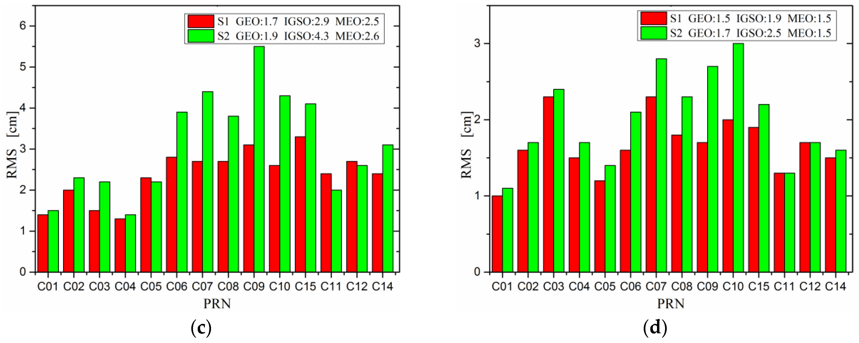
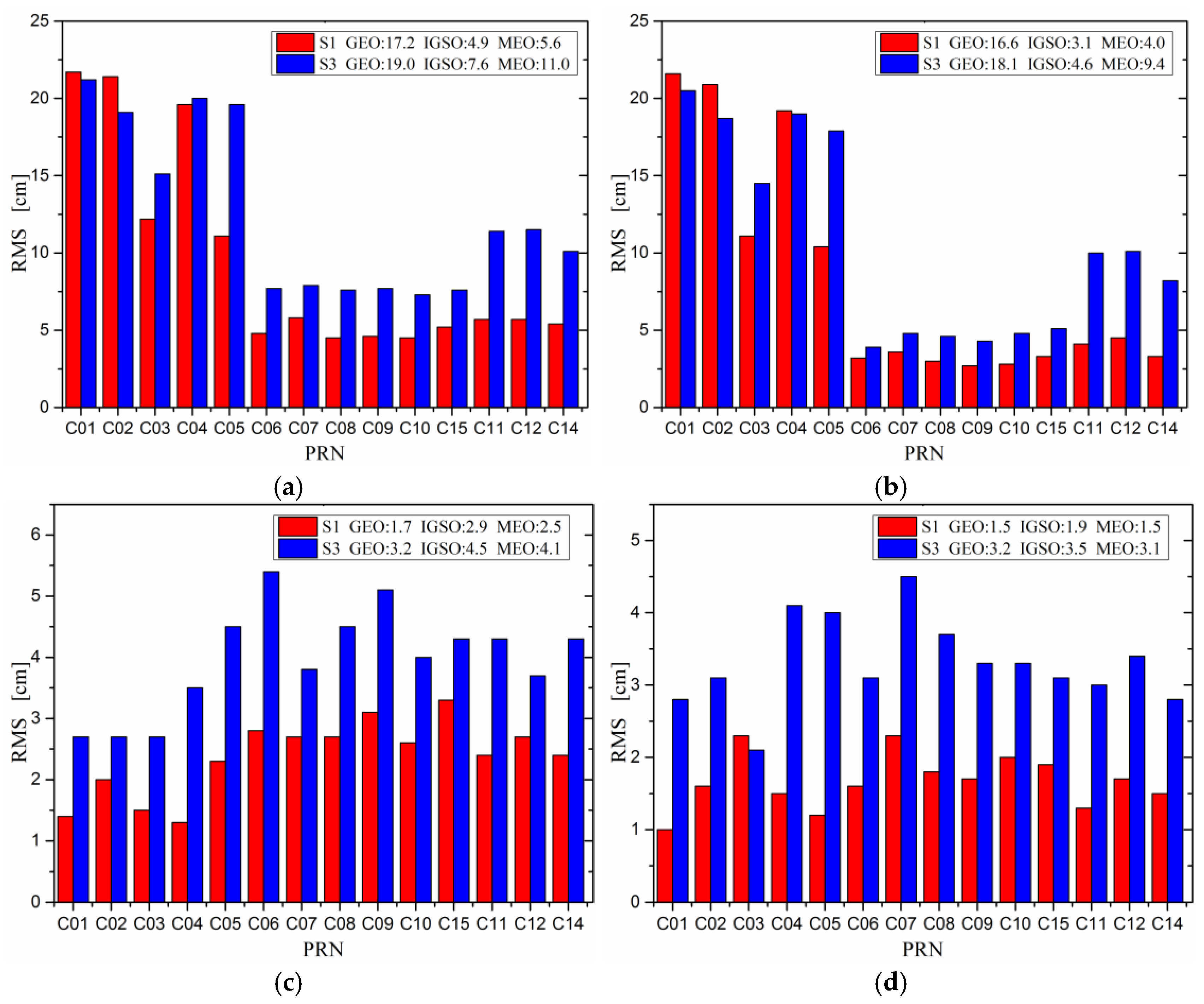
| Satellite Type | PRN | Along-Track | Cross-Track | Radial | 3D | ||||
|---|---|---|---|---|---|---|---|---|---|
| S1 | S2 | S1 | S2 | S1 | S2 | S1 | S2 | ||
| GEO | C01 | 21.6 | 21.5 | 1.4 | 1.5 | 1.0 | 1.1 | 21.7 | 21.8 |
| C02 | 20.9 | 24.5 | 2.0 | 2.3 | 1.6 | 1.7 | 21.4 | 24.8 | |
| C03 | 11.1 | 16.0 | 1.5 | 2.2 | 2.3 | 2.4 | 12.2 | 16.8 | |
| C04 | 19.2 | 21.0 | 1.3 | 1.4 | 1.5 | 1.7 | 19.6 | 21.4 | |
| C05 | 10.4 | 14.0 | 2.3 | 2.2 | 1.2 | 1.4 | 11.1 | 14.4 | |
| Mean | 16.6 | 19.4 | 1.7 | 1.9 | 1.5 | 1.7 | 17.2 | 19.8 | |
| IGSO | C06 | 3.2 | 5.2 | 2.8 | 3.9 | 1.6 | 2.1 | 4.8 | 7.0 |
| C07 | 3.6 | 5.8 | 2.7 | 4.4 | 2.3 | 2.8 | 5.8 | 8.7 | |
| C08 | 3.0 | 4.7 | 2.7 | 3.8 | 1.8 | 2.3 | 4.5 | 6.6 | |
| C09 | 2.7 | 6.5 | 3.1 | 5.5 | 1.7 | 2.7 | 4.6 | 8.6 | |
| C10 | 2.8 | 5.5 | 2.6 | 4.3 | 2.0 | 3.0 | 4.5 | 7.9 | |
| C15 | 3.3 | 4.6 | 3.3 | 4.1 | 1.9 | 2.2 | 5.2 | 7.4 | |
| Mean | 3.1 | 5.4 | 2.9 | 4.3 | 1.9 | 2.5 | 4.9 | 7.7 | |
| MEO | C11 | 4.1 | 4.4 | 2.4 | 2.0 | 1.3 | 1.3 | 5.7 | 5.1 |
| C12 | 4.5 | 5.7 | 2.7 | 2.6 | 1.7 | 1.7 | 5.7 | 6.7 | |
| C14 | 3.3 | 4.6 | 2.4 | 3.1 | 1.5 | 1.6 | 5.4 | 5.9 | |
| Mean | 4.0 | 4.9 | 2.5 | 2.6 | 1.5 | 1.5 | 5.6 | 5.9 | |
| Satellite Type | PRN | Along-Track | Cross-Track | Radial | 3D | ||||
|---|---|---|---|---|---|---|---|---|---|
| S1 | S2 | S1 | S2 | S1 | S2 | S1 | S2 | ||
| GEO | C01 | 217.5 | 227 | 287.3 | 287.8 | 11.5 | 10.8 | 369.6 | 376.8 |
| C02 | 256.7 | 169.3 | 367.4 | 366.1 | 13.8 | 13.5 | 455.8 | 410.1 | |
| C03 | 61.7 | 108.1 | 430.3 | 430.7 | 22.0 | 22.1 | 443.8 | 456.1 | |
| C04 | 182.7 | 122.4 | 67.6 | 89.7 | 34.8 | 37.1 | 200.3 | 172.4 | |
| C05 | 144.1 | 123.1 | 351.5 | 348.9 | 13.7 | 14.1 | 397.6 | 385.6 | |
| mean | 172.5 | 150.0 | 300.8 | 304.6 | 19.2 | 19.5 | 373.4 | 360.2 | |
| IGSO | C06 | 11.7 | 8.9 | 20.4 | 17.1 | 6.4 | 7.1 | 24.5 | 20.0 |
| C07 | 10.7 | 12.4 | 21.7 | 18.1 | 10.7 | 11.2 | 26.6 | 24.7 | |
| C08 | 14.3 | 12.2 | 19.6 | 18.6 | 7.6 | 9.8 | 25.6 | 23.9 | |
| C09 | 13.5 | 15.5 | 19.3 | 17.9 | 5.9 | 7.8 | 24.5 | 25.3 | |
| C10 | 17.2 | 20.4 | 21.0 | 19.8 | 8.8 | 9.2 | 28.8 | 32.7 | |
| C15 | 16.6 | 12.3 | 16.3 | 15.2 | 5.1 | 5.5 | 24.0 | 23.1 | |
| mean | 14.0 | 13.6 | 19.7 | 17.8 | 7.4 | 8.4 | 25.7 | 25.0 | |
| MEO | C11 | 10.2 | 8.1 | 5.9 | 5.5 | 3.9 | 3.1 | 12.4 | 9.9 |
| C12 | 10.8 | 8.5 | 6.2 | 5.9 | 4.2 | 3.7 | 13.2 | 11.2 | |
| C14 | 8.3 | 8.5 | 9.9 | 9.2 | 3.8 | 4.4 | 13.7 | 11.8 | |
| mean | 9.8 | 8.4 | 7.3 | 6.9 | 4.0 | 3.7 | 13.1 | 11.0 | |
| Result | Normal Points | MEAN | STD | RMS | ||||
|---|---|---|---|---|---|---|---|---|
| PRN | S1 | S2 | S1 | S2 | S1 | S2 | ||
| C01 | 69 | −63.7 | −63.1 | 17.0 | 17.7 | 65.9 | 65.6 | |
| C08 | 20 | 1.0 | 0.4 | 1.4 | 2.4 | 1.7 | 2.4 | |
| C10 | 33 | −0.3 | −3.1 | 5.3 | 5.4 | 5.3 | 6.2 | |
| C11 | 65 | −1.8 | −1.4 | 2.8 | 3.2 | 3.3 | 3.5 | |
| PRN | C01 | C02 | C03 | C04 | C05 | C06 | C07 | C08 | C09 | C10 | C15 | C11 | C12 | C14 | |
|---|---|---|---|---|---|---|---|---|---|---|---|---|---|---|---|
| Strategies | |||||||||||||||
| S1/S3 | 51.5 | 44.7 | 38.4 | 53.7 | 45.2 | 38.0 | 37.8 | 39.5 | 40.2 | 40.6 | 42.1 | 25.2 | 26.8 | 28.1 | |
| S2/S4 | 65.2 | 51.3 | 44.8 | 60.0 | 51.3 | 45.0 | 44.9 | 46.4 | 46.4 | 47.2 | 48.6 | 26.9 | 28.1 | 29.8 | |
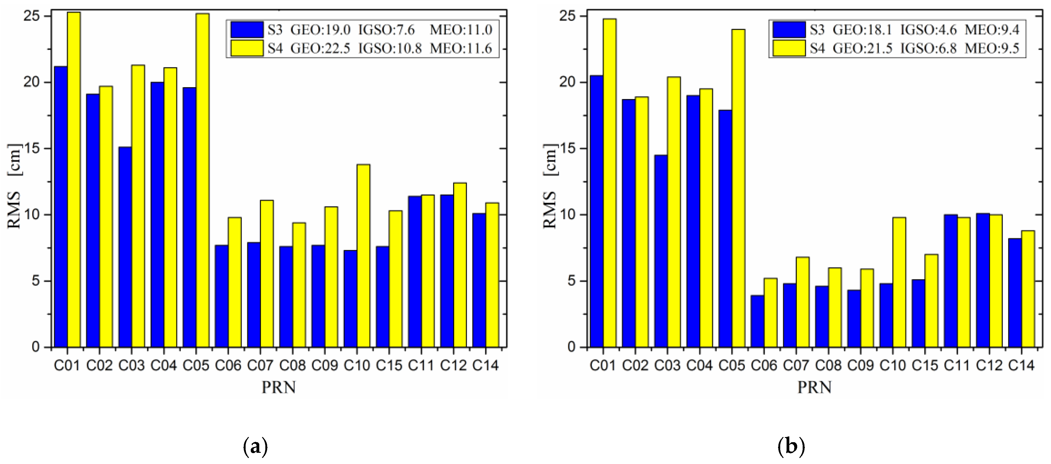
| Satellite Type | PRN | Along-Track | Cross-Track | Radial | 3D | ||||
|---|---|---|---|---|---|---|---|---|---|
| S3 | S4 | S3 | S4 | S3 | S4 | S3 | S4 | ||
| GEO | C01 | 20.5 | 24.8 | 2.7 | 3.3 | 2.8 | 3.5 | 21.2 | 25.3 |
| C02 | 18.7 | 18.9 | 2.7 | 3.3 | 3.1 | 4.2 | 19.1 | 19.7 | |
| C03 | 14.5 | 20.4 | 2.7 | 3.5 | 2.1 | 2.5 | 15.1 | 21.3 | |
| C04 | 19.0 | 19.5 | 3.5 | 4.9 | 4.1 | 4.8 | 20.0 | 21.1 | |
| C05 | 17.9 | 24.0 | 4.5 | 5.1 | 4.0 | 4.5 | 19.6 | 25.2 | |
| mean | 18.1 | 21.5 | 3.2 | 4.0 | 3.2 | 3.9 | 19.0 | 22.5 | |
| IGSO | C06 | 3.9 | 5.2 | 5.4 | 6.4 | 3.1 | 3.8 | 7.7 | 9.8 |
| C07 | 4.8 | 6.8 | 3.8 | 6.2 | 4.5 | 5.2 | 7.9 | 11.1 | |
| C08 | 4.6 | 6.0 | 4.5 | 4.9 | 3.7 | 4.8 | 7.6 | 9.4 | |
| C09 | 4.3 | 5.9 | 5.1 | 6.9 | 3.3 | 4.5 | 7.7 | 10.6 | |
| C10 | 4.8 | 9.8 | 4.0 | 7.2 | 3.3 | 4.2 | 7.3 | 13.8 | |
| C15 | 5.1 | 7.0 | 4.3 | 5.8 | 3.1 | 3.8 | 7.6 | 10.3 | |
| mean | 4.6 | 6.8 | 4.5 | 6.2 | 3.5 | 4.4 | 7.6 | 10.8 | |
| MEO | C11 | 10.0 | 9.8 | 4.3 | 4.6 | 3.0 | 3.2 | 11.4 | 11.5 |
| C12 | 10.1 | 10.0 | 3.7 | 4.4 | 3.4 | 3.5 | 11.5 | 12.4 | |
| C14 | 8.2 | 8.8 | 4.3 | 5.1 | 2.8 | 2.7 | 10.1 | 10.9 | |
| mean | 9.4 | 9.5 | 4.1 | 4.7 | 3.1 | 3.1 | 11.0 | 11.6 | |
| Strategy | Along-Track | Cross-Track | Radial | 3D | ||||
|---|---|---|---|---|---|---|---|---|
| S3 | S4 | S3 | S4 | S3 | S4 | S3 | S4 | |
| C01 | 214.2 | 228.7 | 288.4 | 290.6 | 13.1 | 13.7 | 368.6 | 380.4 |
| C02 | 355.7 | 269.8 | 386.5 | 391.8 | 16.1 | 15.6 | 551.3 | 483.3 |
| C03 | 149.9 | 152.6 | 442.4 | 455.2 | 38.4 | 47.2 | 477.8 | 492.6 |
| C04 | 190.2 | 152.6 | 112.9 | 120.9 | 37.8 | 38.1 | 228.9 | 194.7 |
| C05 | 143.1 | 125.8 | 363.0 | 341.3 | 15.8 | 16.6 | 407.8 | 401.1 |
| Mean | 210.6 | 185.9 | 318.6 | 320.0 | 24.2 | 26.2 | 406.9 | 390.4 |
| C06 | 10.3 | 12.1 | 20.4 | 44.1 | 6.5 | 7.2 | 24.0 | 23.3 |
| C07 | 10.2 | 13.1 | 18.8 | 22.2 | 9.5 | 12.2 | 23.5 | 29.4 |
| C08 | 12.8 | 10.0 | 19.6 | 24.7 | 6.3 | 7.2 | 24.9 | 27.5 |
| C09 | 11.9 | 17.2 | 21.0 | 22.0 | 5.6 | 7.6 | 25.0 | 29.3 |
| C10 | 14.0 | 27.9 | 18.4 | 24.8 | 7.7 | 8.6 | 24.7 | 39.0 |
| C15 | 15.9 | 14.6 | 15.4 | 19.6 | 5.6 | 5.9 | 23.1 | 25.4 |
| Mean | 12.5 | 15.8 | 18.9 | 26.2 | 6.9 | 8.1 | 24.2 | 29.0 |
| C11 | 14.5 | 13.1 | 7.9 | 9.7 | 4.9 | 4.2 | 17.3 | 17.1 |
| C12 | 16.1 | 15.6 | 8.4 | 10.6 | 5.2 | 4.8 | 19.0 | 19.6 |
| C14 | 13.7 | 14.8 | 11.2 | 10.5 | 4.7 | 4.7 | 18.6 | 19.2 |
| Mean | 14.8 | 14.5 | 9.1 | 10.3 | 4.9 | 4.6 | 18.3 | 18.6 |
| PRN | Normal Points | MEAN | STD | RMS | |||
|---|---|---|---|---|---|---|---|
| S3 | S4 | S3 | S4 | S3 | S4 | ||
| C01 | 69 | −65.1 | −64.5 | 18.3 | 17.7 | 67.6 | 66.9 |
| C08 | 20 | 0.9 | 1.4 | 4.6 | 6.0 | 4.6 | 6.1 |
| C10 | 33 | −3.1 | −9.4 | 13.2 | 13.9 | 13.4 | 16.6 |
| C11 | 65 | −0.7 | 1.0 | 4.7 | 5.5 | 4.8 | 5.6 |
| Precision | Along-Track | Cross-Track | Radial | 3D | |||||
|---|---|---|---|---|---|---|---|---|---|
| Type | S1 | S3 | S1 | S3 | S1 | S3 | S1 | S3 | |
| GEO | 16.6 | 18.1 | 1.7 | 3.2 | 1.5 | 3.2 | 17.2 | 19.0 | |
| IGSO | 3.1 | 4.6 | 2.9 | 4.5 | 1.9 | 3.5 | 4.9 | 7.6 | |
| MEO | 4.0 | 9.4 | 2.5 | 4.1 | 1.5 | 3.1 | 5.6 | 11.0 | |
© 2017 by the authors. Licensee MDPI, Basel, Switzerland. This article is an open access article distributed under the terms and conditions of the Creative Commons Attribution (CC BY) license (http://creativecommons.org/licenses/by/4.0/).
Share and Cite
Chen, M.; Liu, Y.; Guo, J.; Song, W.; Zhang, P.; Wu, J.; Zhang, D. Precise Orbit Determination of BeiDou Satellites with Contributions from Chinese National Continuous Operating Reference Stations. Remote Sens. 2017, 9, 810. https://doi.org/10.3390/rs9080810
Chen M, Liu Y, Guo J, Song W, Zhang P, Wu J, Zhang D. Precise Orbit Determination of BeiDou Satellites with Contributions from Chinese National Continuous Operating Reference Stations. Remote Sensing. 2017; 9(8):810. https://doi.org/10.3390/rs9080810
Chicago/Turabian StyleChen, Ming, Yang Liu, Jiming Guo, Weiwei Song, Peng Zhang, Junli Wu, and Di Zhang. 2017. "Precise Orbit Determination of BeiDou Satellites with Contributions from Chinese National Continuous Operating Reference Stations" Remote Sensing 9, no. 8: 810. https://doi.org/10.3390/rs9080810