Assessing Impacts of Land Use Changes on the Hydrology of a Lowland Rainforest Catchment in Ghana, West Africa


1
Department of Geomatics Engineering, University of Mines and Technology, P.O. Box 237, Tarkwa, Ghana
2
Centre for Water Resources Research, University of KwaZulu-Natal, PBAG x01, Scottsville 3209, Pietermaritzburg, South Africa
3
School of Engineering, University of KwaZulu-Natal, PBAG x01, Scottsville 3209, Durban, South Africa
4
South African Environmental Observation Network, Grasslands-Wetlands-Forests Node, P.O. Box 13053, Cascades 3202, Pietermaritzburg, South Africa
*
Author to whom correspondence should be addressed.
Water 2018, 10(1), 9; https://doi.org/10.3390/w10010009
Submission received: 29 September 2017
/
Revised: 1 November 2017
/
Accepted: 28 November 2017
/
Published: 23 December 2017
Abstract
:Impact assessments of actual and potential land use (LU) changes on hydrology are vital in land use planning, which is a prerequisite for effective water resources management. In this study, impacts of actual, as well as potential, LU changes on the hydrology of the Bonsa catchment (1482 km2), Ghana, West Africa, were assessed using the Agricultural Catchments Research Unit (ACRU) hydrological model. Baseline, current and potential future LU maps for three scenarios, namely, business-as-usual (BAU), economic growth (EG) and economic growth and reforestation (EGR), driven by observed climate between 1990 and 2009, were used for the study. The results indicate that peak and dry season streamflows between 1991 and 2011 have increased by 21% and 37%, respectively, under the current land use in comparison to the baseline due to a decrease in evergreen and secondary forests by 18% and 39%, respectively, and an increase in settlements, mining areas and shrubs/farms by 81%, 310% and 343%, respectively. The potential future LU scenarios suggest that there may be further increases in streamflows, but the historical land use changes between 1991 and 2011 were so substantial that they will continue to impact streamflow changes in any of the future land use scenarios. The study also showed that variability of streamflow changes at the catchment scale was lower than at the subcatchment scale. For the scenarios of potential future LU changes, the BAU shows the highest increases in streamflows, while the EGR shows the least. Policy interventions for effective management of the catchment are recommended.
1. Introduction
Rapid population growth, rural-urban migration, urbanization, agricultural intensification and extensification, as well as expansion in surface mining, are some of the major causes of land use (LU) changes in West Africa [1,2,3,4]. According to FAO [1], about 32 million ha of forest were converted to other land uses between 1990 and 2010 in West and Central Africa. Land use changes modify the partitioning of precipitation between the components of the hydrological cycle, which can impact negatively on the environment and socioeconomic wellbeing of people. To effectively manage water resources in a catchment, the historical and present, as well as the potential future impacts of land use changes need to be assessed [5]. These results are vital in efficient land use planning, which is a prerequisite for effective water resources management.
The impacts of land cover/land use changes on hydrology have been assessed over the past several decades, using (i) field-based data-driven statistical methods, based on single catchments or paired catchments [6,7] and (ii) hydrological modelling [8,9,10,11,12,13]. Hydrological modelling using physically based tools are reported to provide reasonable representation of observed hydrological processes for large areas, and also enable rapid evaluation of catchment development scenarios [14], using relatively less time and resources than field studies. Modelling also allows extrapolation of field measurements over large areas and the projection of future hydrological conditions. Therefore, for regions with less data in addition to challenges with financial and technical resources, the use of physically based tools to derive maximum information from limited data has been recommended [15]. Thus, hydrological models, which link model parameters to physically measurable catchment parameters to assess impacts of land use changes on hydrology, have received much attention in the literature [16,17,18,19,20,21]. The use of physically based models is underpinned by the fact that the models integrate the heterogeneity of landscape processes, which has been found to be useful in the simulation of hydrological components for ungauged basins [22].
In West Africa, both field-based studies and hydrological modelling has been used to assess impacts of land use changes on hydrology at various scales [14,17,23,24,25,26,27]. However, in the rainforest regions of the south, where the majority of West African population live, there remains a lack of knowledge on the hydrological impacts of land use changes at the local scale, despite land use changes being significant over the past three decades [1,28]. Previous land use change impact studies on hydrology in West Africa have been mainly undertaken in the semi-arid areas and the Sahel parts of the region [14,17,19,20,23,24,25,26,27,29]. These regions have vastly different vegetation and climate compared to the rainforest regions of the south. Previous studies in the savannah and Sahel regions [14] also relied on limited data, including extreme and unrealistic land use scenarios (e.g., 100% deforestation/afforestation). Thus, there is a need for studies that use plausible land use scenarios that account for simultaneous removal and regeneration of vegetation, as well as gradual changes in impervious surface areas, for both historical and future time slices. Beyond this, the literature provides evidence of the importance of locally relevant studies. For example, several studies [17,21,30,31] have shown that impacts of land use change on hydrology depend on a variety of local factors including climate, vegetation and the location of the land use within a catchment, making it unrealistic to arrive at generalized conclusions about land use change impacts on hydrology.
In the southern rainforest Bonsa catchment of the Ankobra River basin in Ghana, West Africa, land uses have changed significantly over the past three decades. Mining areas have increased over twofold, while settlements and shrubs/farms increased more than three- and fourfold, respectively, leading to overall annual deforestation rates of 0.3% between 1986 and 1991, 0.7% between 1991 and 2002, and 2% between 2002 and 2011 [28]. It is also expected that in the near future, rates of land use changes may be substantially higher than the current rates. There is lack of understanding of the impacts of these land use changes and potential future changes on the hydrological regimes. Prior studies have mainly focused on impacts of mining on water quality [32,33,34] and pollution by airborne particulate matter [35]. With the substantial land use changes in the past and the potential for higher rates in the future, it is important to understand how these changes will impact on the local hydrology to allow for effective land use planning, environmental management, as well as sustainable utilization of the natural resources. Conclusions of such a study will be useful to understanding impacts of similar lowland rainforest catchments of West Africa, informing further studies, as well as the management and development of those catchments.
Thus this study seeks to understand how lowland rainforest catchments in West Africa have responded hydrologically to historical land use changes and how they will respond to land use changes in the future under three development scenarios, using the Bonsa catchment of Ghana as a representative study site. In addition to a baseline (1991) and current (2011) land use scenarios, three future land use scenarios developed in a previous study [36], namely: (i) the business-as-usual (BAU); (ii) the economic-growth (EG), and; (iii) the economic growth and reforestation (EGR) scenarios, were used. This study builds on a companion paper [37], which has demonstrated that the Agricultural Catchments Research Unit (ACRU) hydrological model [38] is a suitable tool for modelling the hydrology of Bonsa catchment. Several studies have also applied the ACRU model successfully to assess the impacts of land use changes on the hydrology of catchments with diverse land uses and climates [21,39], demonstrating the sensitivity of the model to land uses and changes thereof. The study investigates the hydrological impacts on the environment. Unlike previous studies in West Africa, this study analyzes a wide range of streamflow parameters, using flow duration curves and seasonal and annual streamflows, to account for both extreme and median flow conditions, as these are important for water supply management, flood protection, and environmental protection. The study also investigates the spatial variability of streamflow changes in response to land use changes, which has been ignored in all but one previous study [29] in West Africa.
2. Materials and Methods
2.1. Study Area Description
The Bonsa catchment of the Ankobra River basin in Ghana, West Africa (Figure 1), is located between longitudes 1°41′ and 2°13′ W and latitudes 5°4′ and 5°43′ N. The Bonsa River, which provides many local communities with water for domestic as well as industrial purposes, flows in a southwesterly direction to join the Ankobra River, which flows in a north-south direction and joins the Atlantic Ocean at Axim. The population of the large towns in the catchment, such as Tarkwa and Abosso, has more than doubled in the past 30 years, with an annual growth rate of approximately 2% [40]. The catchment has a low relief, with the elevations ranging between 30 and 340 m above mean sea level, and drains an area of approximately 1482 km2. The catchment has a convective rainfall regime [41] with two peak rainfall seasons, the major peak is from March/April to July and the minor peak is from August/September to November (Figure 1). The mean rainfall ranges between 1500 mm and 2150 mm per annum [42], while the annual average minimum and maximum temperatures are 23 °C and 31 °C, respectively. Dominant land cover consists of evergreen and secondary forests, shrub lands and farms, while the geology is mostly Birimian and Tarkwaian rock systems [32] and the soil is mostly Ferric Acrisols. The economic activities in the catchment include open-pit gold mining (small and large scale), rubber plantations (small and large scale) and cocoa and food crop cultivation.
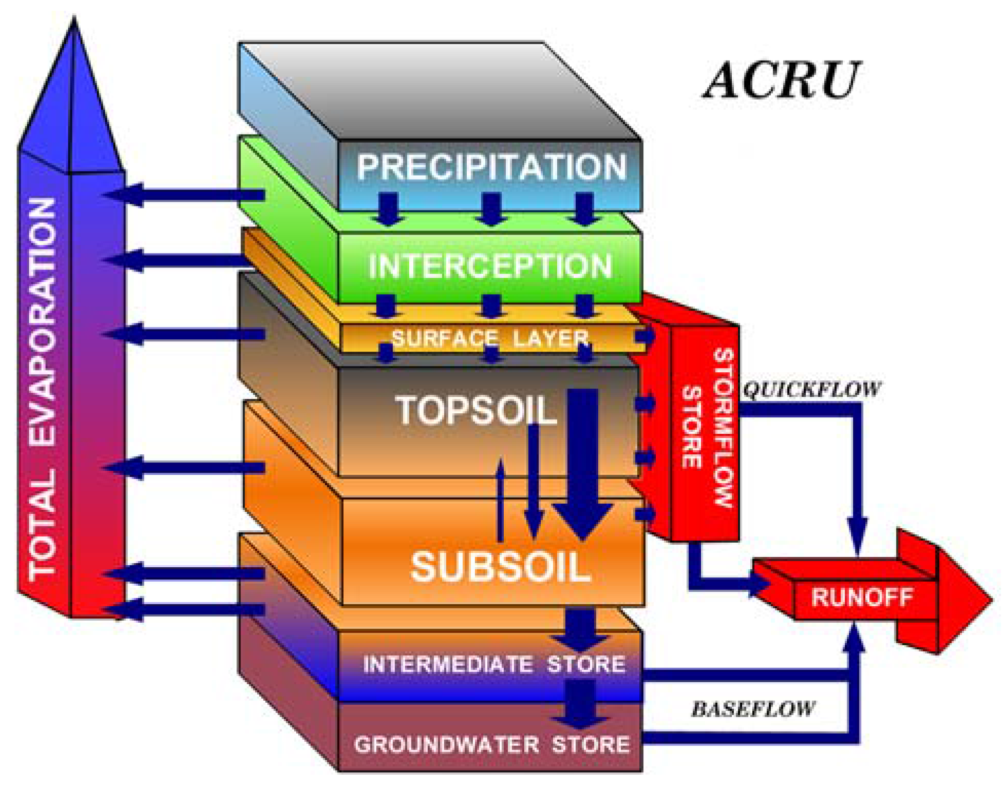
2.2. The ACRU Hydrological Model
The Agricultural Catchments Research Unit (ACRU) Model [38] is a daily time step physical-conceptual agro-hydrological model developed in the former School of Bioresources Engineering and Environmental Hydrology of the University of KwaZulu-Natal, South Africa, to simulate catchment hydrological responses to land management. It is a multi-purpose model (Figure 2) that can be used for catchment water resources assessment, design floods, irrigation water planning, assessment of land use change and climate change impacts [38]. A detailed description of the model is available in Schulze [38]. The ACRU model has previously been applied in the catchment with a Nash-Sutcliffe efficiency (NSE) index of 0.6 and 0.5, and R2 of 0.8 and 0.7, for calibration and validation of monthly flows, respectively [37]. This study builds on this application, as well as knowledge gained through several applications of the model in a variety of catchments [13,43,44], with a wide range of climates and land uses.
2.3. Data Acquisition and Model Configuration
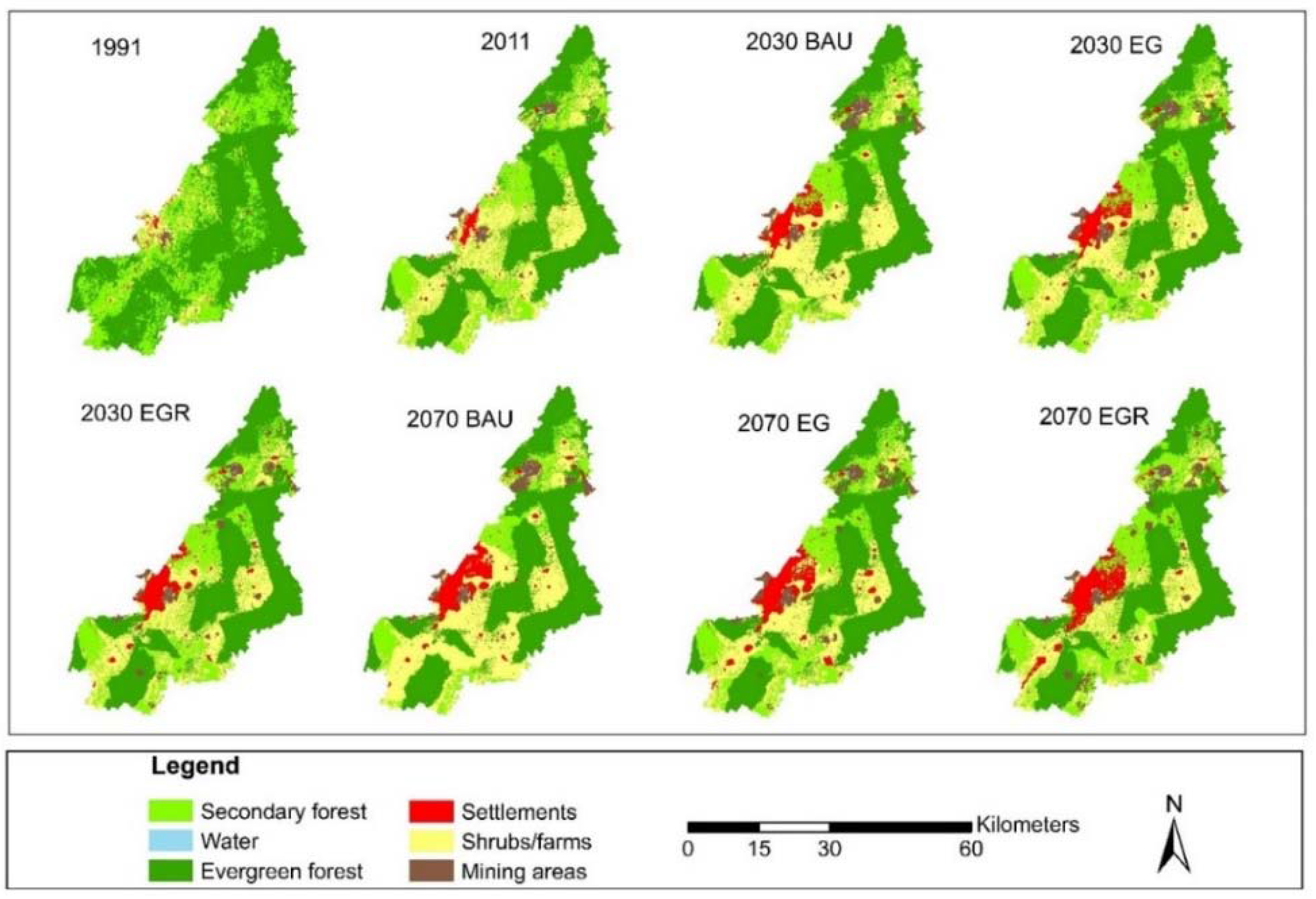
The Bonsa catchment was delineated and subdivided into 103 subcatchments using digitized river courses and contour maps obtained from the Survey of Ghana (SOG). The subcatchments were further subdivided into hydrological response units (HRUs), based on the catchment land uses (Figure 3), in order to provide a more homogeneous land use area for hydrological simulation. The subcatchments and HRUs were configured such that their streamflows cascade (route) into each other in a logical sequence representative of river flow. An example of the flow sequence of subcatchments is shown in Figure 4. The land use parameters used in this study were the same as those used in the calibration and validation study [37], which were obtained after a sensitivity analysis in the Bonsa catchment. The assumption made was that the land use types remained the same, however, the area and distribution changed depending on land use scenario (Figure 3; Table 1). The streamflow simulation control variables, which determine the amount of rainfall that becomes groundwater and streamflow during a day, were also the same as those applied in the calibration and validation study.
Similarly, the soils information and parameters were those used in the calibration and validation study, which were obtained from a generalized soil map from the Soil Research Institute (SRI) of Ghana and Dwomo and Dedzoe [45], as well as computation of soil water content at permanent wilting point and drained upper limit, using their clay proportions in the pedotransfer equations developed by Schulze [38]. Climate records were obtained from the Ghana Meteorological Agency (GMA) for the period of 1980 to 2011. Due to data gaps and outliers in the rainfall records, the data was preprocessed [37] before using it in the ACRU model. Reference potential evaporation was calculated using the Hargreaves and Samani method [46].
To determine the impacts of land use changes on hydrology, the calibrated ACRU model was used to simulate the streamflow for the Bonsa catchment using the 1991 land use map and climate records from 1990 to 2009. This was considered the baseline scenario against which the simulated streamflows under the current (2011) and future (2030, 2070) land use scenarios (Figure 3) were compared.
The 1991 land use was selected as the baseline land use as it represents a period prior to substantial land use changes in the catchment. It is assumed to be close to the natural land use conditions of the Bonsa catchment, and thus that the streamflows simulated under the 1991 land use are relatively close to the natural flow regime of the Bonsa River. The future land use scenarios were derived in [36] using Dynamic Conversion of Land Use and its Effects modelling framework (Dyna-CLUE) model [47]. After validating the Dyna-CLUE model for the historical land use simulation, the three potential future scenarios of land use changes were created to simulate potential land use in the Bonsa catchment. The land use scenarios were: (i) the business-as-usual (BAU), where the current economic development objectives persist; (ii) the economic growth (EG), where economic development is promoted through expansion in mining operations as well as increased rubber production, and; (iii) the economic growth and reforestation (EGR), which is similar to the EG, but prescribes higher rates of reforestation into the future.
In order to attribute hydrological responses to changes in land uses the climate records from 1990 to 2009 were used for the hydrological simulation of each of the land use scenarios, and the soils and the streamflow control variables were held constant. The method of assessing land use change impacts on hydrology, used in this study, was adapted from several studies including Li, Coe, Ramankutty and De Jong [14], Park, Park, Joh, Shin, Kwon, Srinivasan and Kim [9], Cornelissen, Diekkrueger and Giertz [19] and Bossa, Diekkrueger and Agbossou [29].
3. Results
The temporal changes in streamflows across the selected land use scenarios are described using tables and figures, while maps are used to explore the spatial variability of streamflow responses to the current, as well as future land use (LU) scenarios.
3.1. Temporal Analysis of Impacts of Current and Future Land Use Changes
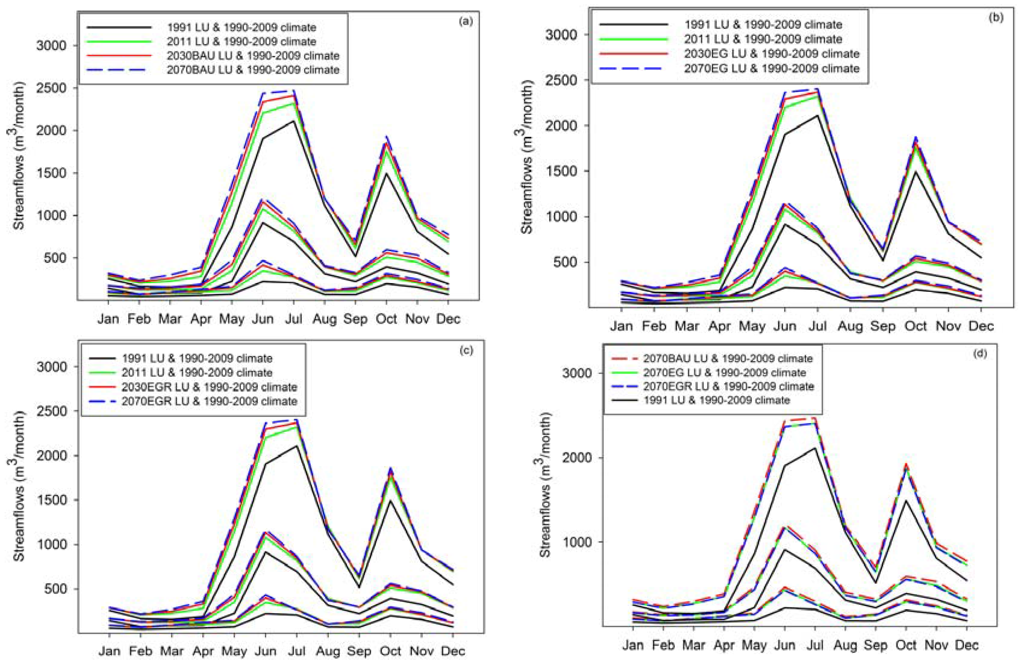
LU changes between 1991 and 2011, in the form of deforestation and urbanization, in the Bonsa catchment have resulted in increased inter-annual, dry season, major and minor peak season streamflows (Table 2). The highest increase in streamflows of 37% (i.e., an increase from 590 m3 to 808 m3) occurred in the dry season, while the major peak season had the lowest increase of 21% (i.e., 2524 m3–3055 m3). The current (2011) LU changes also resulted in increased high, median and low simulated flows (Figure 5 and Figure 6). The streamflows simulated under the potential future LU change scenarios (BAU, EG and EGR) followed the same trend as those for the current (2011) LU, but with higher magnitudes of change, which increased with time. The dry season streamflows showed the highest increases regardless of the LU scenario or time slice (Table 2). The high, median and low flows also increased under the future LU scenarios (Figure 5 and Figure 6). The differences between streamflows simulated under the different future LU scenarios were, however, small, but the streamflow increases simulated under the BAU LU scenarios were the highest, while those of the EGR were the lowest, irrespective of the time slice. Under all the land use scenarios (current and potential future), streamflow increases for the low flows were relatively higher than the increases in the high flows (Figure 6).
The simulated increases in streamflows between 1991 and 2011 may be attributable to the extensive deforestation which occurred during the period, where evergreen and secondary forests reduced by 18% (from 917 to 755 km2) and 39% (from 457 to 280 km2), respectively. During the same period settlements areas increased by 81%, while shrubs/farms (from 90 to 399 km2) and mining areas (from 6 to 24 km2) increased three fold. The substantial increase in streamflows in the current (2011) scenario is largely because of the over 300% increase in shrubs/farms area between 1991 and 2011. The conversion of evergreen forests with higher crop coefficients (CAY) and interception loss by vegetation (VEGINT) [37] to land uses with lower values of the parameters led to the increased streamflows.
Streamflows simulated under the potential future land use scenarios were higher than those of the baseline and current land uses because of a further land use changes. For example, mining, shrubs/farms and settlements in the BAU scenario increased eightfold (from 6 to 53 km2), fourfold (from 90 to 482 km2) and sixfold (from 12 to 91 km2) between 1991 and 2070 (Table 1), respectively, while the evergreen and secondary forests reduced drastically. However, although streamflows have generally increased with time, their seasonal pattern have not changed (Figure 5).
Streamflow responses simulated under the future land uses were generally similar because the proportion of land uses in the scenarios were relatively similar. Nonetheless, the slightly lower streamflows for the EG and the EGR scenarios, compared to the BAU land uses, is because of the higher overall forested areas (secondary and evergreen forest), lower shrubs/farm areas and higher mining areas in the EG and EGR scenarios (Table 1).
3.2. Spatial Analysis of the Hydrological Impacts of Land Use Changes
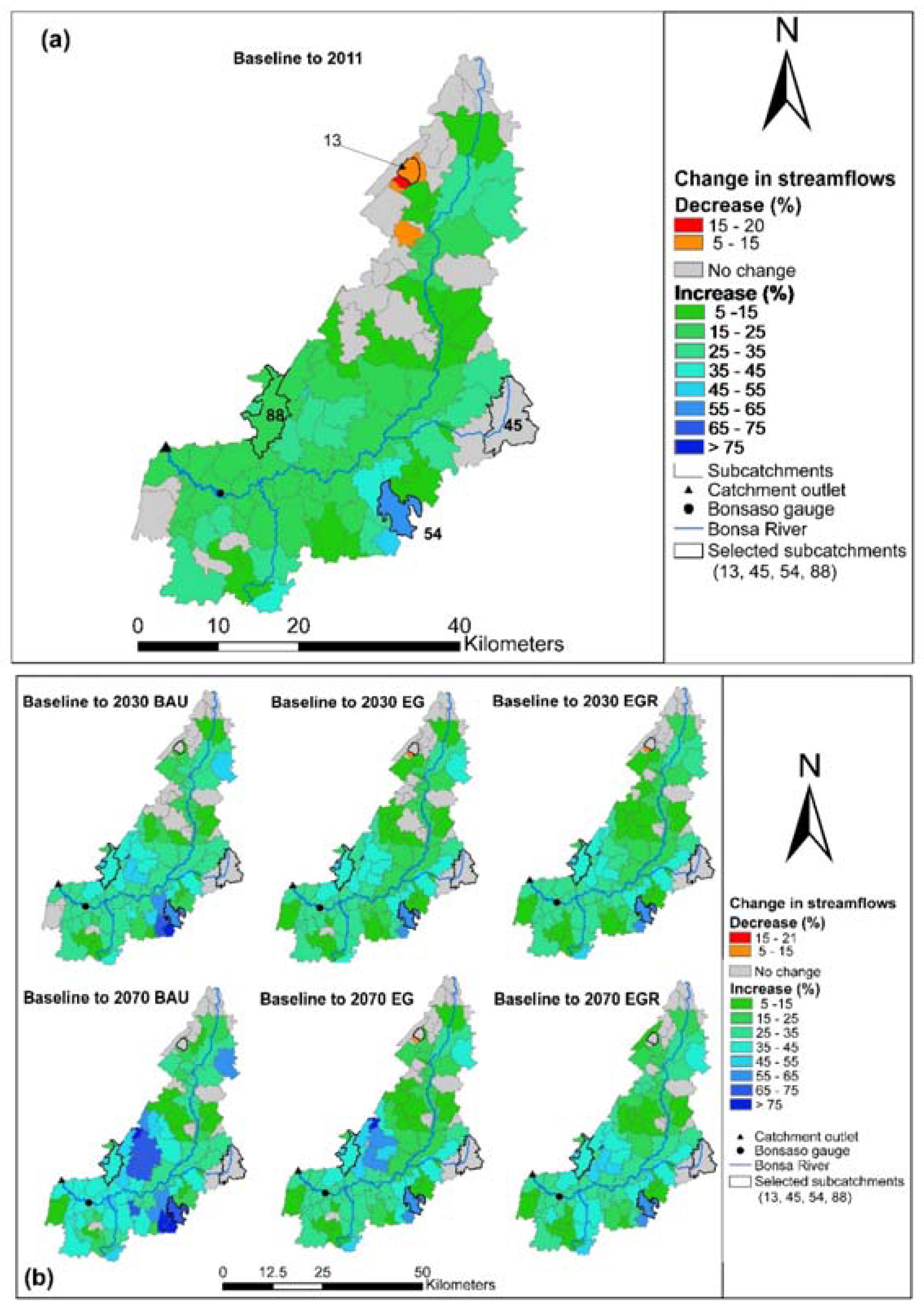
The spatial pattern of changes in streamflows due to land use change is similar across the land use scenarios, however, the magnitude of change in streamflow varies (Figure 7). Due to the conversion of mainly secondary forests in 1991 to shrubs/farms in 2011, subcatchments along the main stem of the river showed increases in streamflow of between 15% and 25% (Figure 7a), while the subcatchments in the northern, southwestern and the eastern part of the Bonsa catchment, which have remained evergreen forests between 1991 and 2011, showed no changes in streamflows. The highest increases in streamflows (45–65%) between the baseline and current land use scenario occurred in the southeastern part of Bonsa (subcatchment 54 and surrounding areas) due to the reduction of evergreen and secondary forests in 2011, increased settlement area and the introduction of shrubs/farms. The only decreases in streamflows (5–20%) were those that occurred in the subcatchments on the outskirts of Damang in the northwest. These decreases are due to the maturation of secondary to evergreen forests between 1991 and 2011, and the conversion of patches of shrubs/farms to secondary forests (Figure 3). This conversion is possibly due to the abandonment of farms when mining leases were granted to mining companies in the early 1990s.
Under the 2030 land use scenarios (Figure 7b), changes of between 25% and 35% in streamflow relative to the baseline were evident for subcatchments along the main stem of the Bonsa River for the BAU scenario. Under the EG and EGR scenarios the streamflow increases were lower towards the northern part of the main stem (between 15 and 25%), while in the southeastern part of the main stem the streamflow increases (between 25% and 35%) were similar to those under the BAU scenario. These increases are attributable to the predominantly secondary forests along the main river stem in 1991 being converted to shrubs/farms, mining areas and settlements in the future scenarios (Figure 3). The lower increases in streamflows in the north under the EG and EGR scenarios in comparison to the BAU scenario are due to the larger areas of shrubs/farms in BAU scenario. In the west central part of the Bonsa catchment increases in streamflow were evident in all future 2030 scenarios with larger increases evident under the BAU LU scenario. These increases were due to increasing areas of settlements, shrubs/farms and mining areas. The largest increases in streamflow under the 2030 land use scenarios were evident in subcatchment 54 and its surrounding subcatchments to the northwest and southwest (Figure 7b), with increases of 55–75% under the BAU scenario and increases of 55–65% under the EG and EGR scenarios. These changes were due to the conversion of mainly evergreen and secondary forests in 1991 to shrubs/farms, mining and settlement areas in the future LU scenarios (Figure 3), with the conversion to shrubs/farms being greatest in the BAU scenario. For those subcatchments in the northern, middle and the eastern part of Bonsa catchment, where the evergreen forest remained under the future LU scenarios, no changes in streamflows were evident.
Under the 2070 LU scenarios, the streamflow changes followed the same trend as those simulated under the 2030 LU scenarios, except that the magnitude of increases was greater (Figure 7b) due to the larger mining, settlement and shrubs/farms areas (Figure 3). For example, in the west central subcatchments near Tarkwa, the streamflow increases ranged from 35 to more than 75% for the 2070 LU scenarios, while under the 2030 LU scenarios the increases were below 35%.
4. Discussion
4.1. Historical and Potential Future Land Use Change Impacts on Hydrology
The results of the study have shown that the hydrology of the Bonsa catchment has been altered (Figure 5 and Figure 6) from the selected baseline hydrological regime. The land use of the Bonsa catchment prior to the implementation of the economic liberalization programs of the Ghana government in the late 1980s and early 1990s was mainly evergreen forests, but currently (2011) only 51% of it remains [28]. Although the study shows a substantial alteration of the hydrology between the baseline (1991) and current (2011) land use (LU) scenarios, the seasonal patterns of the high and low flows have been maintained. However, the current hydrological regime (i.e., 2011 land use scenario), shows significantly higher peak and dry season flows relative to the baseline flows. The higher flows in the current hydrological regime is because of deforestation and urbanization, as well as expansion in surface mines [28].
Deforestation has been the result of many activities including timber logging and increasing farming activities by the local people, as well as the felling of trees for fuelwood. The creation of new and the expansion of existing mines in the eastern and the northern part of the study area also contributed to the increased streamflows. The mines are located close to the main stem and tributaries of the Bonsa River, thereby affecting the streamflows directly. The almost 81% increase in settlement areas between 1991 and 2011, especially around the town of Tarkwa, which also has streams that link directly to the Bonsa River, and the threefold increase in shrubs/farms and mining areas together with the reduction of secondary forest by 39% (Table 1), contributed to the increased streamflows at the catchment outlet for the current (2011) land use scenario. However, the threefold increase in shrubs/farms from 1991 to 2011 and the relatively lower crop coefficient and interception loss for the LU, compared to evergreen forests, which previously dominated the catchment, were the main reasons why streamflows in 2011 were substantially higher than those in 1991.
The study has further shown that under future land use scenarios, simulated streamflows were higher relative to the baseline and their magnitudes increased with time. However, the difference between the outlet streamflows of the future land uses was minor due to the relatively similar proportion of different land use areas. The slightly higher streamflows for the BAU scenarios, compared to the EG and the EGR scenarios, is because of the slightly smaller and larger areas occupied by shrubs/farms and forests, respectively, in those scenarios. The low difference between outlet streamflows of the future land use scenarios implies that striving towards any one of them for planning may not significantly influence the streamflow responses at the catchment outlet. This may be because the catchment has already undergone significant land use changes (e.g., over 300% increase in shrubs/farms between 1991 and 2011).
The spatial pattern of streamflow increases is similar across all land use scenarios, but the increases become greater and more evident with time. The increases in streamflows were greatest in the central part of the catchment in and around Tarkwa, where there are settlements, shrubs/farms and mining areas. The increases in streamflows were, however, dampened towards the catchment outlet due to streamflow contributions from more forested areas. Overall, the variability of streamflow changes was highest for the BAU land use, while that of the EGR scenario was lowest. Catchment management under changing land uses may therefore be enhanced by taking into account outlet streamflows, as well as streamflows in the interior parts.
4.2. Dealing with Uncertainties in Land Use Change Impact Assessments
Several studies [9,21,48,49] have applied distributed models to study impacts of land use changes on hydrology as the models are intended to simulate the physical reality of the hydrological cycle, spatially and temporally, which is vital for effective land use planning and water management. The use of physically based semi-distributed model such as ACRU reduces the data requirements that would have been necessary for a fully distributed model, and justifies its application in a data-scarce region such as the Bonsa catchment in Ghana, West Africa.
The poor spatial resolution (scale: 1:250,000) of the applied soil map and the pragmatism of the land use parameters required by the ACRU model, determined specifically for the Bonsa catchment, has contributed to reducing the simulation accuracies in the study. Shortcomings of this study also include the use of single streamflow gauge, as well as few rain gauges for ACRU model simulation. Model calibration and validation would have been more robust if several streamflow [50] and rainfall gauges were available, as the streamflows in the Bonsa catchment are more variable at the subcatchment than at the catchment scale. The abovementioned uncertainties were minimized by using physically meaningful sensitivity analysis of the ACRU model parameters in a companion paper [37] for the Bonsa catchment.
The utilization of actual land use data, as well as multiple land use scenarios generated from land use modelling for determining impacts on hydrology, is intended to produce simulated responses representative of likely land use change scenarios. Land use models generate land use distributions for each scenario, based on statistically significant socioeconomic and biophysical driving factors, and allows the incorporation of gradual changes and the regeneration of land use types at different locations within a catchment, simultaneously. The challenge with modelled land use scenarios used in this study was the lack of adequate input data for estimation of the historical land use model parameters, which resulted in only a moderate land use simulation accuracy [51]. To account for these uncertainties, this study used three land use scenarios (BAU, EG and EGR) based on three development pathways. The BAU scenario was based on recent historical (2002–2011) trends of land use changes and the EG scenario assumed increasing secondary forest area through rubber plantations. For the EGR land use scenario, the Ghana Forestry Commission (2013) policy to reforest 200 km2/year of forest in the country were implemented.
Land use impacts are also affected by climate changes [52,53] and their joint impacts are nonlinear [15], but this study is focused on the analysis of exploratory scenarios to better understand how land use change scenarios impact streamflows under the historical climate. However, in order to fully comprehend the magnitudes and reasons for future hydrological changes in the Bonsa catchment in Ghana, West Africa, further studies which include climate change scenarios are needed.
4.3. Management of Bonsa and Similar Catchments in West Africa
As the major finding in this study is that streamflows increase in both the current (2011) and the potential future hydrological regimes, it is suggested that an integrated and adaptive approach [54,55] should be adopted to manage the Bonsa and similar catchments in West Africa. Thus, in the current land use scenario, effective storm water management such as increasing infiltration in settlement, shrubs/farms and mining areas are needed, and going into the future intensive rather than extensive farming should be investigated to assess the potential costs and benefits. Reforestation should also be targeted in areas dominated by shrub lands. Installation of additional streamflow and rain gauges and continuous environmental monitoring and evaluation should also be planned to assist in addressing data shortages.
5. Conclusions
The objectives of this study were to quantitatively assess the impacts of land use changes from the historical period to potential future in the Bonsa catchment of Ghana, West Africa. The study used historical, current and potential future land use maps as inputs to a calibrated ACRU hydrological model to simulate hydrological regime for each land use scenario. The study shows that current (2011) land use changes relative to the baseline (1991) land use have significantly increased peak and dry season flows. It has also been revealed that the potential future land use changes may increase total streamflows, although the seasonal patterns are not expected to change. The variability of streamflow changes has been shown to be higher at the subcatchment than at the catchment scale. The BAU and the EGR scenarios are expected to generate the highest and the lowest streamflow increases, respectively. In order to manage the Bonsa catchment effectively, adaptive catchment-wide management strategies, including installation of equipment and data capturing, research, reforestation, implementation of ecologically friendly and effective storm water management strategies for urbanized, farms and mining areas and conducting monitoring and evaluation of restoration efforts, are required.
Acknowledgments
The authors wish to thank the University of KwaZulu Natal (UKZN) for the financial support to publish this paper and the anonymous reviewers for their comments.
Author Contributions
Michael S. Aduah conceived and designed the experiments with technical advice from Graham P.W. Jewitt and Michele L.W Toucher. Michael S. Aduah performed the experiments, analyzed the results and wrote the paper with technical and editorial advice from supervisors (Graham P.W. Jewitt and Michele L.W. Toucher).
Conflicts of Interest
The authors declare no conflict of interest.
References
- Food and Agriculture Organization (FAO). Global Forest Resources Assessment 2010: Main Report; Food and Agriculture Organization of the United Nations: Rome, Italy, 2010; p. 378. [Google Scholar]
- Schueler, V.; Kuemmerle, T.; Schroeder, H. Impacts of surface gold mining on land use systems in Western Ghana. Ambio 2011, 40, 528–539. [Google Scholar] [CrossRef] [PubMed]
- Kusimi, J.M. Assessing land use and land cover change in the Wassa West District of Ghana using remote sensing. GeoJournal 2008, 71, 249–259. [Google Scholar] [CrossRef]
- Braimoh, A.K.; Vlek, P.L.G. Land-cover change trajectories in northern Ghana. Environ. Manag. 2005, 36, 356–373. [Google Scholar] [CrossRef] [PubMed]
- Choi, J.; Engel, B.A.; Muthukrishnan, S.; Harbor, J. Gis based long term hydrologic impact evaluation for watershed urbanization. J. Am. Water Resour. Assoc. 2003, 39, 623–635. [Google Scholar] [CrossRef]
- Brown, A.E.; Zhang, L.; McMahon, T.A.; Western, A.W.; Vertessy, R.A. A review of paired catchment studies for determining changes in water yield resulting from alterations in vegetation. J. Hydrol. 2005, 310, 28–61. [Google Scholar] [CrossRef]
- Lane, P.N.J.; Best, A.E.; Hickel, K.; Zhang, L. The response of flow duration curves to afforestation. J. Hydrol. 2005, 310, 253–265. [Google Scholar] [CrossRef]
- Chu, H.-J.; Lin, Y.-P.; Huang, C.-W.; Hsu, C.-Y.; Chen, H.-Y. Modelling the hydrologic effects of dynamic land-use change using a distributed hydrologic model and a spatial land-use allocation model. Hydrol. Process. 2010, 24, 2538–2554. [Google Scholar] [CrossRef]
- Park, J.Y.; Park, M.J.; Joh, H.K.; Shin, H.J.; Kwon, H.J.; Srinivasan, R.; Kim, S.J. Assessment of MIROC3.2 hires climate and CLUE-s land use change impacts on watershed hydrology using SWAT. Trans. Asabe 2011, 54, 1713–1724. [Google Scholar] [CrossRef]
- Tong, S.T.Y.; Sun, Y.; Ranatunga, T.; He, J.; Yang, Y.J. Predicting plausible impacts of sets of climate and land use change scenarios on water resources. Appl. Geogr. 2012, 32, 477–489. [Google Scholar] [CrossRef]
- Gosling, S.N.; Taylor, R.G.; Arnell, N.W.; Todd, M.C. A comparative analysis of projected impacts of climate change on river runoff from global and catchment-scale hydrological models. Hydrol. Earth Syst. Sci. 2011, 15, 279–294. [Google Scholar] [CrossRef]
- Moradkhani, H.; Baird, R.G.; Wherry, S.A. Assessment of climate change impact on floodplain and hydrologic ecotones. J. Hydrol. 2010, 395, 264–278. [Google Scholar] [CrossRef]
- Warburton, M.L.; Schulze, R.E.; Jewitt, G.P.W. Confirmation of acru model results for applications in land use and climate change studies. Hydrol. Earth Syst. Sci. 2010, 14, 2399–2414. [Google Scholar] [CrossRef]
- Li, K.Y.; Coe, M.T.; Ramankutty, N.; De Jong, R. Modeling the hydrological impact of land-use change in West Africa. J. Hydrol. 2007, 337, 258–268. [Google Scholar] [CrossRef]
- Li, Z.; Liu, W.; Zhang, X.; Zheng, F. Impacts of land use change and climate variability on hydrology in an agricultural catchment on the loess plateau of China. J. Hydrol. 2009, 377, 35–42. [Google Scholar] [CrossRef]
- Legesse, D.; Vallet-Coulomb, C.; Gasse, F. Hydrological response of a catchment to climate and land use changes in Tropical Africa: Case study South Central Ethiopia. J. Hydrol. 2003, 275, 67–85. [Google Scholar] [CrossRef]
- Mahe, G.; Paturel, J.E.; Servat, E.; Conway, D.; Dezetter, A. The impact of land use change on soil water holding capacity and river flow modelling in the Nakambe River, Burkina-Faso. J. Hydrol. 2005, 300, 33–43. [Google Scholar] [CrossRef]
- Seguis, L.; Cappelaere, B.; Milesi, G.; Peugeot, C.; Massuel, S.; Favreau, G. Simulated impacts of climate change and land-clearing on runoff from a small sahelian catchment. Hydrol. Process. 2004, 18, 3401–3413. [Google Scholar] [CrossRef]
- Cornelissen, T.; Diekkrueger, B.; Giertz, S. A comparison of hydrological models for assessing the impact of land use and climate change on discharge in a tropical catchment. J. Hydrol. 2013, 498, 221–236. [Google Scholar] [CrossRef]
- Bossa, A.Y.; Diekkrueger, B.; Giertz, S.; Steup, G.; Sintondji, L.O.; Agbossou, E.K.; Hiepe, C. Modeling the effects of crop patterns and management scenarios on N and P loads to surface water and groundwater in a semi-humid catchment (West Africa). Agric. Water Manag. 2012, 115, 20–37. [Google Scholar] [CrossRef]
- Warburton, M.L.; Schulze, R.E.; Jewitt, G.P.W. Hydrological impacts of land use change in three diverse South African catchments. J. Hydrol. 2012, 414–415, 118–135. [Google Scholar] [CrossRef]
- Hrachowitz, M.; Savenije, H.H.G.; Bloeschl, G.; McDonnell, J.J.; Sivapalan, M.; Pomeroy, J.W.; Arheimer, B.; Blume, T.; Clark, M.P.; Ehret, U.; et al. A decade of Predictions in Ungauged Basins (PUB)—A review. Hydrol. Sci. J. 2013, 58, 1198–1255. [Google Scholar] [CrossRef]
- Giertz, S.; Diekkruger, B. Analysis of the hydrological processes in a small headwater catchment in Benin (West Africa). Phys. Chem. Earth 2003, 28, 1333–1341. [Google Scholar] [CrossRef]
- Giertz, S.; Junge, B.; Diekkrüger, B. Assessing the effects of land use change on soil physical properties and hydrological processes in the sub-humid tropical environment of West Africa. Phys. Chem. Earth Parts A B C 2005, 30, 485–496. [Google Scholar] [CrossRef]
- Van de Giesen, N.; Stomph, T.-J.; Ajayi, A.E.; Bagayoko, F. Scale effects in hortonian surface runoff on agricultural slopes in West Africa: Field data and models. Agric. Ecosyst. Environ. 2011, 142, 95–101. [Google Scholar] [CrossRef]
- Leblanc, M.J.; Favreau, G.; Massuel, S.; Tweed, S.O.; Loireau, M.; Cappelaere, B. Land clearance and hydrological change in the Sahel: SW Niger. Glob. Planet. Chang. 2008, 61, 135–150. [Google Scholar] [CrossRef]
- Valentin, C.; Rajot, J.L.; Mitja, D. Responses of soil crusting, runoff and erosion to fallowing in the sub-humid and semi-arid regions of West Africa. Agric. Ecosyst. Environ. 2004, 104, 287–302. [Google Scholar] [CrossRef]
- Aduah, M.S.; Warburton, M.L.; Jewitt, G. Analysis of land cover changes in the Bonsa Catchment, Ankobra basin, Ghana. Appl. Ecol. Environ. Res. 2015, 13, 935–955. [Google Scholar] [CrossRef]
- Bossa, A.Y.; Diekkrueger, B.; Agbossou, E.K. Scenario-based impacts of land use and climate change on land and water degradation from the Meso to Regional Scale. Water 2014, 6, 3152–3181. [Google Scholar] [CrossRef]
- Boulain, N.; Cappelaere, B.; Séguis, L.; Favreau, G.; Gignoux, J. Water balance and vegetation change in the Sahel: A case study at the watershed scale with an eco-hydrological model. J. Arid Environ. 2009, 73, 1125–1135. [Google Scholar] [CrossRef]
- Klocking, B.; Haberlandt, U. Impact of land use changes on water dynamics—A case study in temperate meso and macroscale river basins. Phys. Chem. Earth 2002, 27, 619–629. [Google Scholar] [CrossRef]
- Akabzaa, T.M.; Jamieson, H.E.; Jorgenson, N.; Nyame, K. The combined impact of mine drainage in the Ankobra River Basin, SW Ghana. Mine Water Environ. 2009, 28, 50–64. [Google Scholar] [CrossRef]
- Armah, F.A.; Luginaah, I.; Ason, B. Water quality index in the Tarkwa gold mining area in Ghana. J. Transdiscipl. Environ. Stud. (TES) 2012, 11, 1–15. [Google Scholar]
- Kortatsi, B.K. Acidifcation of groundwater and its implication on rural water supply in the Ankobra basin, Ghana. West Afr. J. Appl. Ecol. 2003, 4, 35–47. [Google Scholar]
- Bansah, K.J.; Amegbey, N. Ambient particulate matter monitoring—A case study at Tarkwa. Res. J. Environ. Earth Sci. 2012, 4, 419–423. [Google Scholar]
- Aduah, M.S.; Toucher, M.L.; Jewitt, G.P.W. Estimating potential future land use in the bonsa catchment, Ghana, West Africa. S. Afr. J. Geomat. under review.
- Aduah, M.S.; Jewitt, G.P.W.; Toucher, M.L.W. Assessing suitability of the ACRU hydrological model in a rainforest catchment in Ghana, West Africa. Water Sci. 2017, accepted, in press. [Google Scholar] [CrossRef]
- Schulze, R.E. Hydrology and Agrohydrology: A Text to Accompany the ACRU 3.00 Agrohydrological Modelling System; Report TT69/95; Water Research Commission: Pretoria, South Africa, 1995. [Google Scholar]
- Schulze, R.E. Modelling hydrological responses to land use and climate change: A Southern African perspective. Ambio 2000, 29, 12–22. [Google Scholar] [CrossRef]
- Ghana Statistical Service. 2010 Population & Housing Census, National Analytical Report; Ghana Statistical Service: Accra, Ghana, 2013; p. 430.
- Jackson, B.; Nicholson, S.E.; Klotter, D. Mesoscale convective systems over Western Equatorial Africa and their relationship to large-scale circulation. Mon. Weather Rev. 2009, 137, 1272–1294. [Google Scholar] [CrossRef]
- Yidana, S.M.; Ophori, D.; Banoeng-Yakubo, B. Irrigation water resource management for sustainable agriculture—The Ankobra basin, Ghana. J. Irrig. Drain. Eng. ASCE 2007, 133, 609–615. [Google Scholar] [CrossRef]
- Forbes, K.A.; Kienzle, S.W.; Coburn, C.A.; Byrne, J.M.; Rasmussen, J. Simulating the hydrological response to predicted climate change on a watershed in southern Alberta, Canada. Clim. Chang. 2011, 105, 555–576. [Google Scholar] [CrossRef]
- Ghile, Y.B. An Adaptation of the SCS-ACRU Hydrograph Generating Technique for Application in Eritrea. Master’s Thesis, University of Natal, Durban, South Africa, 2004. [Google Scholar]
- Dwomo, O.; Dedzoe, C.D. Oxisol (ferralsol) development in two agro-ecological zones of ghana: A preliminary evaluation of some profiles. J. Sci. Technol. Kwame Nkrumah Univ. Sci. Technol. (KNUST) 2010, 30, 11–28. [Google Scholar] [CrossRef]
- Hargreaves, G.; Hargreaves, G.; Riley, J. Agricultural benefits for Senegal River Basin. J. Irrig. Drain. Eng. 1985, 111, 113–124. [Google Scholar] [CrossRef]
- Verburg, P.; Veldkamp, A. Projecting land use transitions at forest fringes in the philippines at two spatial scales. Landsc. Ecol. 2004, 19, 77–98. [Google Scholar] [CrossRef]
- Legesse, D.; Abiye, T.A.; Vallet-Coulomb, C.; Abate, H. Stream flow sensitivity to climate and land cover changes: Meki River, Ethiopia. Hydrol. Earth Syst. Sci. 2010, 14, 2277–2287. [Google Scholar] [CrossRef] [Green Version]
- Breuer, L.; Huisman, J.A.; Willems, P.; Bormann, H.; Bronstert, A.; Croke, B.F.W.; Frede, H.G.; Gräff, T.; Hubrechts, L.; Jakeman, A.J.; et al. Assessing the impact of land use change on hydrology by ensemble modeling (LUCHEM). I: Model intercomparison with current land use. Adv. Water Resour. 2009, 32, 129–146. [Google Scholar] [CrossRef]
- Wi, S.; Yang, Y.C.E.; Steinschneider, S.; Khalil, A.; Brown, C.M. Calibration approaches for distributed hydrologic models in poorly gaged basins: Implication for streamflow projections under climate change. Hydrol. Earth Syst. Sci. 2015, 19, 857–876. [Google Scholar] [CrossRef]
- Aduah, M.S. Impacts of Global Changes on a Lowland Rainforest Region of West Africa; University of KwaZulu-Natal: Pietermaritzburg, South Africa, 2016. [Google Scholar]
- Dale, V.H. The relationship between land-use change and climate change. Ecol. Appl. 1997, 7, 753–769. [Google Scholar] [CrossRef]
- D’Orgeval, T.; Polcher, J. Impacts of precipitation events and land-use changes on West African river discharges during the years 1951–2000. Clim. Dyn. 2008, 31, 249–262. [Google Scholar] [CrossRef]
- Homa, E.S.; Brown, C.; McGarigal, K.; Compton, B.W.; Jackson, S.D. Estimating hydrologic alteration from basin characteristics in massachusetts. J. Hydrol. 2013, 503, 196–208. [Google Scholar] [CrossRef]
- Richter, B.D.; Baumgartner, J.V.; Wigington, R.; Braun, D.P. How much water does a river need? Freshw. Biol. 1997, 37, 231–249. [Google Scholar] [CrossRef]
Figure 1.
Map of the Bonsa catchment in the Ankobra basin of Ghana (top) and a graph showing mean monthly climate between 1990 and 2009 for Tarkwa (bottom).
Figure 1.
Map of the Bonsa catchment in the Ankobra basin of Ghana (top) and a graph showing mean monthly climate between 1990 and 2009 for Tarkwa (bottom).
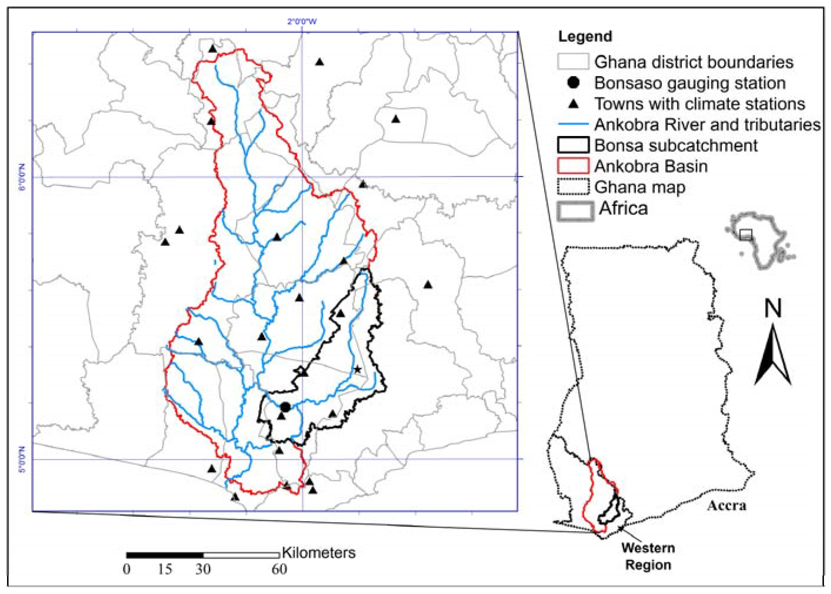
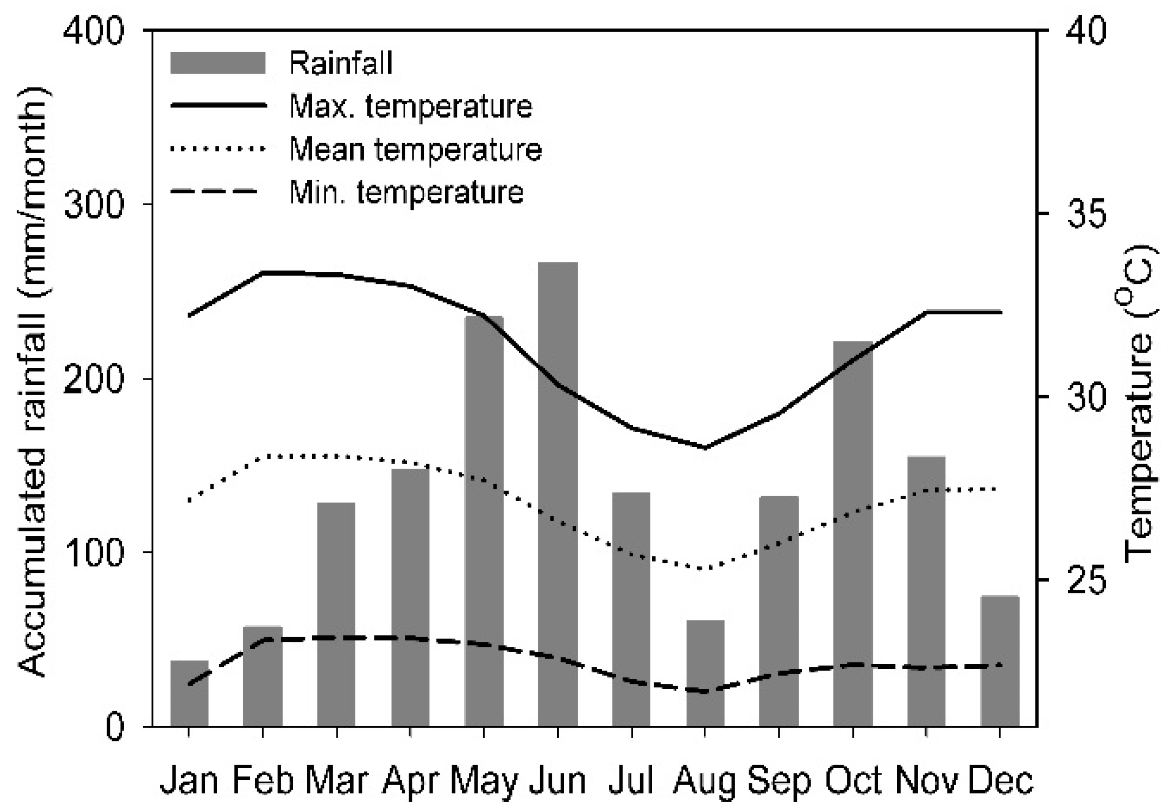
Figure 2.
Representation of hydrological processes in the Agricultural Catchments Research Unit (ACRU) model (Schulze, 1995).
Figure 2.
Representation of hydrological processes in the Agricultural Catchments Research Unit (ACRU) model (Schulze, 1995).

Figure 3.
Maps for baseline land use (1991), current (2011) land use and future land use scenarios in the Bonsa catchment, generated from mapping and land use simulation [37].
Figure 3.
Maps for baseline land use (1991), current (2011) land use and future land use scenarios in the Bonsa catchment, generated from mapping and land use simulation [37].

Figure 4.
Example of subcatchment (a) and hydrological response unit (HRU) streamflow configuration (b) for the Bonsa catchment, showing the cascading of water flow from HRUs to subcatchments.
Figure 4.
Example of subcatchment (a) and hydrological response unit (HRU) streamflow configuration (b) for the Bonsa catchment, showing the cascading of water flow from HRUs to subcatchments.
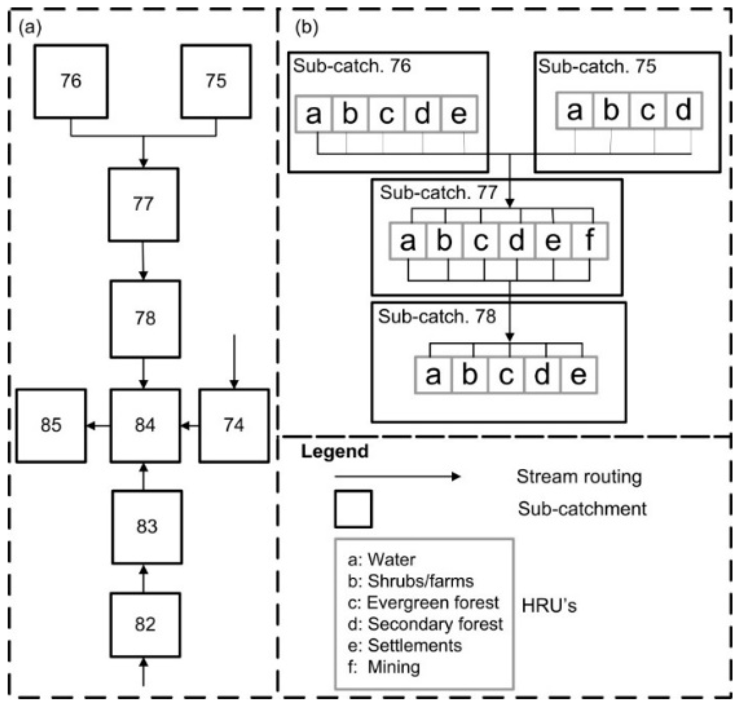
Figure 5.
Monthly 90th (1-in-10-year high), 50th (median flows) and 10th (1-in-10-year low) percentile streamflows for baseline, 2011 land use and (a) BAU; (b) EG; (c) EGR, and; (d) 2070 BAU, EG and EGR land uses.
Figure 5.
Monthly 90th (1-in-10-year high), 50th (median flows) and 10th (1-in-10-year low) percentile streamflows for baseline, 2011 land use and (a) BAU; (b) EG; (c) EGR, and; (d) 2070 BAU, EG and EGR land uses.

Figure 6.
Flow duration curves (FDCs) for 2070 future, baseline (1991) and current (2011) land use scenarios.
Figure 6.
Flow duration curves (FDCs) for 2070 future, baseline (1991) and current (2011) land use scenarios.
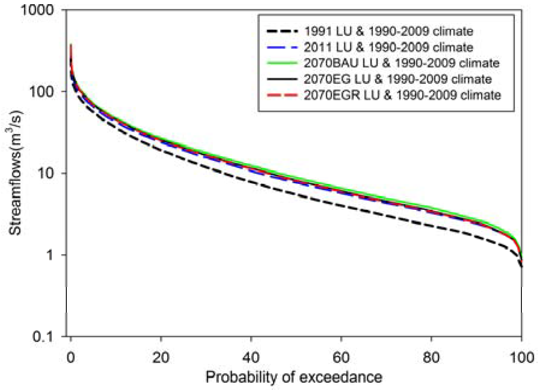
Figure 7.
Changes in mean annual accumulated streamflows relative to the baseline (1991 land use) streamflows for (a) 2011 land use, as well as (b) the potential future land use scenarios. Numbers in maps represents subcatchments.
Figure 7.
Changes in mean annual accumulated streamflows relative to the baseline (1991 land use) streamflows for (a) 2011 land use, as well as (b) the potential future land use scenarios. Numbers in maps represents subcatchments.

Table 1.
Land uses for the Bonsa catchment for the baseline (1991), current (2011) and future scenarios (2030 and 2070).
Table 1.
Land uses for the Bonsa catchment for the baseline (1991), current (2011) and future scenarios (2030 and 2070).
| Scenario/Time Slice | Land Cover (km2) | Total | |||||
|---|---|---|---|---|---|---|---|
| Secondary Forest | Water | Evergreen Forest | Settlements | Shrubs/Farms | Mining Areas | ||
| Baseline | 457.3 (30.8) | 0.2 (0.1) | 916.5 (61.8) | 12.4 (0.8) | 90.0 (6.1) | 5.9 (0.4) | 1482.3 |
| Current | 280.3 (18.9) | 1.4 (0.1) | 754.6 (50.9) | 22.4 (1.5) | 399.4 (26.9) | 24.2 (1.6) | 1482.3 |
| BAU: 2030 | 215.5 (14.5) | 1.4 (0.1) | 728.1 (49.1) | 63.7 (4.3) | 425.3 (28.7) | 48.3 (3.3) | 1482.2 |
| BAU: 2070 | 171.0 (11.5) | 1.4 (0.1) | 683.6 (46.1) | 91.3 (6.2) | 482.1 (32.5) | 52.8 (3.6) | 1482.2 |
| EG: 2030 | 283.9 (19.2) | 1.4 (0.1) | 733.6 (49.5) | 68.8 (4.6) | 340.1 (22.9) | 54.3 (3.7) | 1482.1 |
| EG: 2070 | 294.7 (19.9) | 1.4 (0.1) | 689.4 (46.5) | 95.7 (6.5) | 335.0 (22.6) | 66.0 (4.5) | 1482.2 |
| EGR: 2030 | 303.8 (20.5) | 1.4 (0.1) | 716.0 (48.3) | 66.6 (4.5) | 340.2 (22.9) | 54.3 (3.7) | 1482.2 |
| EGR: 2070 | 350.1 (23.6) | 1.4 (0.1) | 667.7 (45.0) | 100.6 (6.8) | 295.4 (19.9) | 67.2 (4.5) | 1482.2 |
Note: Numbers in brackets are percentages (%).Business-as-usual (BAU); economic growth (EG); economic growth and reforestation (EGR).
Table 2.
Increases in total streamflows relative to the baseline (1991 land use) scenario for the current (2011) and three future land use scenarios (BAU, EG and EGR).
Table 2.
Increases in total streamflows relative to the baseline (1991 land use) scenario for the current (2011) and three future land use scenarios (BAU, EG and EGR).
| Scenario | Annual (%) | Dry Season (%) | Major Peak Season (%) | Minor Peak Season (%) | |
|---|---|---|---|---|---|
| 2011 | 23.3 | 36.9 | 21.0 | 23.9 | |
| BAU | |||||
| 2030 | 32.1 | 48.0 | 30.1 | 33.1 | |
| 2070 | 39.0 | 57.9 | 36.8 | 40.2 | |
| EG | |||||
| 2030 | 27.9 | 40.7 | 26.7 | 28.9 | |
| 2070 | 32.2 | 46.1 | 31.3 | 33.4 | |
| EGR | |||||
| 2030 | 28.1 | 41.2 | 26.8 | 28.9 | |
| 2070 | 31.2 | 44.0 | 30.5 | 32.3 | |
© 2017 by the authors. Licensee MDPI, Basel, Switzerland. This article is an open access article distributed under the terms and conditions of the Creative Commons Attribution (CC BY) license (http://creativecommons.org/licenses/by/4.0/).
Share and Cite
MDPI and ACS Style
Aduah, M.S.; Jewitt, G.P.W.; Toucher, M.L.W. Assessing Impacts of Land Use Changes on the Hydrology of a Lowland Rainforest Catchment in Ghana, West Africa. Water 2018, 10, 9. https://doi.org/10.3390/w10010009
AMA Style
Aduah MS, Jewitt GPW, Toucher MLW. Assessing Impacts of Land Use Changes on the Hydrology of a Lowland Rainforest Catchment in Ghana, West Africa. Water. 2018; 10(1):9. https://doi.org/10.3390/w10010009
Chicago/Turabian StyleAduah, Michael S., Graham P. W. Jewitt, and Michele L. W. Toucher. 2018. "Assessing Impacts of Land Use Changes on the Hydrology of a Lowland Rainforest Catchment in Ghana, West Africa" Water 10, no. 1: 9. https://doi.org/10.3390/w10010009
Note that from the first issue of 2016, this journal uses article numbers instead of page numbers. See further details here.