Urban Floods and Climate Change Adaptation: The Potential of Public Space Design When Accommodating Natural Processes


CIAUD, Centro de Investigação em Arquitetura, Urbanismo e Design, Faculdade de Arquitetura, Universidade de Lisboa, Rua Sá Nogueira, Pólo Universitário do Alto da Ajuda, 1349-063 Lisboa, Portugal
*
Author to whom correspondence should be addressed.
Water 2018, 10(2), 180; https://doi.org/10.3390/w10020180
Submission received: 28 December 2017
/
Revised: 28 January 2018
/
Accepted: 7 February 2018
/
Published: 9 February 2018
(This article belongs to the Special Issue Urban Water Cycle Modelling and Management)
Abstract
:Urban public space is extraordinarily adaptable under a pattern of relatively stable changes. However, when facing unprecedented and potentially extreme climatic changes, public spaces may not have the same adaptation capacity. In this context, planned adaptation gains strength against “business as usual”. While public spaces are among the most vulnerable areas to climatic hazards, they entail relevant characteristics for adaptation efforts. As such, public space design can lead to effective adaptation undertakings, explicitly influencing urban design practices as we know them. Amongst its different intrinsic roles and benefits, such as being a civic common gathering place of social and economic exchanges, public space may have found an enhanced protagonism under the climate change adaptation perspective. In light of the conducted empirical analysis, which gathered existing examples of public spaces with flood adaptation purposes, specific public space potentialities for the application of flood adaptation measures are here identified and characterized. Overall, this research questions the specific social potentiality of public space adaptation in the processes of vulnerability tackling, namely considering the need of alternatives in current flood management practices. Through literature review and case study analysis, it is here argued that: people and communities can be perceived as more than susceptible targets and rather be professed as active agents in the process of managing urban vulnerability; that climate change literacy, through the design of a public space, may endorse an increased common need for action and the pursuit of suitable solutions; and that local know-how and locally-driven design can be considered as a service with added value for adaptation endeavors.
1. Introduction
The idea of public space may be apprehended by a set of two meanings: (1) a conceptual meaning commonly used in political and social science, in which public space, “brings together all the processes that configure the opinion and collective will” as characterized by Innerarity, ([1], p. 10) (author’s translation) and (2) a physical meaning, commonly used in urban planning and design, regarding where and how previous actions are developed [2,3]. More specifically, a space that enables and promotes community life, such as streets, sidewalks, plazas, coffee shops, parks or museums, and that potentially offers services with wide-ranging benefits with tangible and intangible values. Other authors have additionally highlighted pubic space as multidimensional space, with a central social, political and cultural significance [4]. In regards to its physical characteristics, it has been particularly argued on the long-lasting permanence of public space as a structuring urban space [5,6] of interdisciplinary nature [7,8]. Overall, public space may be defined by Hanna Arendt’s communal table: it “gathers us together and yet prevents our falling over each other, so to speak.” ([9], p. 52). In the present article, all these previously mentioned facets of public space are embraced and its specific role in urban adaptation processes is furthermore discussed, namely by arguing that through the application of effective measures in public spaces, communities are facilitated to comprehend, learn, engage and mobilize for climate action.
As highlighted in previous publications [10,11], the distinctiveness of urban territories as major centers of communication, commerce, culture and innovation may empower successful processes and outcomes in the climate change adaptation agenda, due to “interchange processes of products, services and ideas that are processed and expressed in their public spaces” ([2], p. 120, author’s translation). As Jane Jacobs pointed out, in a pioneering critical criticism on modern urbanism orthodoxy that quickly became mainstream faith, “lively, diverse, intense cities contain the seeds of their own regeneration, with energy enough to carry over for problems and needs, outside themselves” ([12], p. 448). What is regularly overlooked in large scale planning and policy—often guided by questionable interests—is a community’s inherent resilience. Not only do people want to be the main actors in the urban space, but also want to be at the center of space design concerns. The currently ongoing project “PSSS—Public Space Service System” [13] acknowledges this recognition of public space potential roles, and is working on new critical concepts for public space assessment, with new criteria within a systemic logic focusing on service and value creation, which is useful for actions calling for urban adaptability.
Concerning the recurrent phenomenon of urban flooding, climate change research has been warning to the fact that traditional flood management practices must be reassessed, namely if projected impacts are to be managed, such as the likely increased frequency and greater intensity of storms (precipitation and storm surges) together with a rise in sea level. This is an increasing threat that affects all the people in a community, particularly the most vulnerable (elderly, children, poor, among others). Indeed, it is possible to verify an emerging change from the conventional focus on reducing the probability to experience floods to the aim to reduce society’s vulnerabilities. This former notion inevitably promoted the emergence of new flood management approaches that started to integrate risk and uncertainty in its practice, notably by fully acknowledging and welcoming the processes of the natural water cycle. Among others, Best Management Practices (BMPs), Green Infrastructure (GI), Integrated Urban Water Management (IUWM), Low Impact Development (LID) or Sustainable Urban Drainage Systems (SUDS) [14] are well representative of these new approaches. All of which implies changes in the relationship between the city and (its) water.
Considering public space as a communal space system that develops spatial services [15], as a collective entity of shared concerns, a new claim for climate change adaptation is presented: the claim that public space may additionally serve as a social beacon for change. In light with Pelling’s findings, people and communities are not only targets but also active agents in the management of vulnerability [16]. Ulrich Beck also highlighted that “what was made by people can also be changed by people” ([17], p. 157). Correspondingly, not only it is in the public space where hazards become tangible to a community, but it may also be where adaptation initiatives may strive. It therefore comes as no surprise that a new variety of insurgent citizenship is arising within public spaces as the urgent matter of climate change adaptation is recognized among our societies. Regardless, bearing in mind the potential severity of the projected impacts that are expected to become increasingly more unavoidable, many authors agree that our society is still not responding accordingly [18].
Some societies have shown to be reluctant of the need to face impending threats of climate change due to an absence of common understanding of what is the “common good”. Hesitant communities may be driven by the fact that climate change is still a much-politicized issue or by the fact that adaptation is still a fairly recent strategy of response. Regardless of the causes in climate change suspicions, some cases provide evidence of an inclination to prioritize other values. Even within developed countries that have suffered direct consequences of severe climate impacts, some communities, such as the case of New Orleans local society [19], have rejected initiatives towards a more adapted urban environment. Other communities, in other situations, also did not initially welcome adaptation actions. This is namely the case of the first attempt to implement the currently internationally recognized concept of the Water Plaza, which can be briefly characterized by being a low-lying square that is submerged only during storm events. Despite a promising start—with an idea that had won the first prize of the 2005 Rotterdam Biennale competition—the first pilot project failed. Risks, such as of children drowning, triggered strong emotional reactions from local citizens who started naming the idea as the “drowning plaza” ([20], pp. 121–122). Having wisely learned from the encountered barriers that prevented the implementation of the first project, the second pilot project had not only a new location, but, more importantly, a new approach towards technical criteria and social participation and is currently considered an exemplary case of concrete climate change adaptation in a highly urbanized area.
Cases like these evidence that social, cultural and emotional factors can be more valued and respected than the need of physical safety or ecological services of public spaces. This fact is one that strengthens the importance of continual community evolvement alongside additional and distinct methods for the dissemination of scientific knowledge with within the agenda of climatic adaptation. According to Van Der Linden, persuasive communication about climate change is only successful when based on an integrated acknowledgement of the psychological processes that control pro-environmental behavior [21]. However, public spaces seem to offer what Van Der Linden considered as fundamental for climate change adaptation engagement: through public spaces and public space design, local aspects of climate change can be made visible and thus meaningful for citizens and their livelihoods.
Furthermore, public spaces provide a source of knowledge and information (besides the mainstreamed sources of science and media) that may be apprehended as an autonomous and independent process. A process with direct learning experiences, based on deep-rooted traditional experience and know-how, in a public domain that is naturally subject to social control. In other words, public spaces may provide extended opportunities for experiential learning that are influenced by specific contexts and social pressures. Through a medium that is closer to people, “climate change literacy” may more likely endorse a common need to search for solutions. As highlighted by CABE (Commission for Architecture and the Built Environment) adaptation of cities to climate-driven threats is strongly dependent on “well-designed, flexible public spaces”([22], p. 2).
When integrating local expertise as well as scientific and technical knowledge in a flexible and clear-cut design, public spaces are not only able to promote adaptation action and reduce risk of disaster, but also improve awareness on climate change. The physical and the social components combined make public spaces favored interfaces for adaptation action. In public spaces, people may “be” as well as “become” both producers and managers of adaptation action. People may “be” producers and managers of adaptation through autonomous, individual or collective involvements—from art manifestations to community-based projects. In addition, people may also “become” both producers and managers of adaptation when awareness is raised through direct consequence of the formerly mentioned processes or through institutional endeavors, by the message of public art and other participative or deliberative actions evolved in public space design. In this line of reasoning, the design of public space sees itself enhanced in the face of impending weather events, being here considered as a determinant for the adaptation of urban territories when facing climate change.
Underlying this assessment lies the argument that public spaces support the new emerging tendency on urban flood management [23], where the precedent goal to effectively and rapidly avoid or convey stormflows is being gradually replaced by the goal to incorporate storm water within the city and through the enhancement of the whole natural water cycle. In other words, that public space helps promote a change of paradigm for more flood-adapted cities that aim to reduce vulnerabilities while integrating environmental, social and economic concerns.
2. Methodology
Climate change adaptation initiatives are still faced with numerous challenges. Most common barriers to adaptation can be associated with “short term thinking of politicians and long term impacts of climate change”, “little finance reserved/available for implementation”, “conflicting interests between involved actors”, “more urgent policy issues need short term attention” or “unclear social costs and benefits of adaptation measures” ([20], p. 139). However, every day successful adaptation examples grow in number, and, as argued by Howe and Mitchell, it is increasingly important to see more empirical studies of adaptation examples rather than just dwell on the barriers to change [24]. New and innovative adaptation projects can be exploited as a creative laboratory, which can serve to propose, assess and monitor solutions through an ongoing learning process that may serve to inform future decisions and reduce generalized hindering constraints.
This research advances from an empirical analysis, which gathered existing examples of public spaces with flood adaptation purposes, and is targeted at identifying and characterizing specific public space potentialities for the application of flood adaptation measures. The presented analysis is based on comprehensive case studies highlighted in research projects, bibliographical reviews, interviews with specialists, networking or in site visits. Besides including main or secondary functions related to flood vulnerability reduction, the chosen range of examples also aimed to select “good quality” cases among a comprehensive group of public space typologies. This research approach is named here “Portfolio Screening”.
For Jan Jacob Trip, public space may be the element of urban development that is most difficult to plan and design as it relates to so many intangible qualities inherent to the quality of place itself [25]. Difficulties in this purpose arise for there is no consensual formula that would define the quality of public space design. Although it is commonly accepted that good design must develop from a sensible understanding of its situation and all its encompassing contexts (environmental, cultural, social, economic and political) [26], and therefore is likely to result in a place that is valued “in general”, a rational may be required in the assessment of adaptation practices.
Based on an exhaustive evaluation of thousands of public spaces worldwide, the non-profit organization Project for Public Spaces (PPS) provides evidence that “great places” generally share four principal attributes, namely: sociability, uses and activities, access and linkages and comfort and image. One may anyhow presume that public spaces that entail flood adaptation measures are likely to include at least one of PPS’s intangible qualities of being “vital”, “useful”, “sustainable” or “safe”.
The Portfolio Screening, i.e., the range of empirically collected examples, is therefore based on the abovementioned references and emphasized attributes. It further encompasses a comprehensive range of public space typologies. For this purpose, the typology of public spaces identified by Brandão was used, namely the differentiation regarding “Layout spaces” (plazas, streets, avenues), “Landscape spaces” (gardens, parks, belvederes, viewpoints), “Itinerating spaces” (stations, interfaces, train-lines, highways, parking lots, silos), “Memory spaces” (cemeteries, memory and monumental spaces), “Commercial spaces” (markets, shopping malls, arcades, temporary markers, kiosks, canopies) and “Generated spaces” (churchyard, passage, gallery, patio, cultural, sports, religious, children’s, lighting, furniture, communication, art) ([27], p. 35). The range of presented examples in the Portfolio Screening therefore covers all the aforementioned types of public spaces.
The gathered range of cases aimed to further provide a geographically representative scope, yet, inevitably, projects with greater dissemination and improved access to information were privileged. The examples presented in the Portfolio Screening specifically involve 19 countries and 72 cities. Together, they are not meant to offer an exhaustive collection but rather a significant sample of designed solutions that endorse further reliable research and decision-making.
3. Public Space Potentialities for the Application of Flood Adaptation Measures
Table 1 advances the conducted empirical analysis, which gathered existing examples of public spaces with flood adaptation purposes, together with the identification of public space potentialities for the application of flood adaptation measures for each presented example.
In several of the examples that enabled this analysis, adaptation measures were unrecognized as such. The existing functional qualities of some cases were rather associated to other, more prevailing, conceptual approaches such as sustainability or flood protection. However, in light of the previous findings, namely in regard to the concept of adaptation [28], all presented examples are considered as adaptation measures. Not only do all examples entail the transposition of uncertainty, and its apparent impediments, into public spaces of multifunctional qualities, but also all examples serve as solid grounds for the assessment of adaptation action.
In light of the examples presented in the Portfolio Screening, it was possible to identify six public space potentialities specifically directed towards the application of flood adaptation measures, namely: (1) the favoring of interdisciplinary design; (2) the possibility to embrace multiple purposes; (3) the promotion of community awareness and engagement and interaction; (4) the comprehension within an extensive physical structure; (5) the possibility to expose and share value and (6) the opportunity to diversify and monitor flood risk. Each of these features will be analyzed in the following pages and further reinforced by the association particular cases from the Portfolio Screening.
3.1. Interdisciplinary Design of Public Spaces
Acknowledging that public space ethics concept may be interpreted as “it is of everyone”, its design therefore is “not a matter of one sole profession, entity or interest group” ([26], p.19, author’s translation). Likewise, Madanipour argues that public spaces should be created by different professionals from different disciplines of the built, natural and social environments or by any professional with multi-disciplinary concerns and awareness [7]. As Lefébvre acutely states, “ultimate illusion: to consider the architects, urbanists or urban planners as experts in space, the greatest judges of spatiality...” ([30], p. 30, author’s translation).
Recalling Horacio Capel’s argument, since the nineteenth century, the subject of urbanism has been excessively controlled by a fierce competition between engineers on the one side and architects on the other. While the first would define and design major infrastructures, the latter would define and design interventions in streets, buildings or green areas. However, as the author highlights, “all this should be at the service of social needs” ([31], p. 92, author’s translation).
Back in the 1870s, Frederick Law Olmsted designed Boston’s Emerald Necklace (#30) (Henceforth, the mentioned examples will be additionally identified with their corresponding number presented in Table 1 to facilitate the access to further information. Emerald Necklace, for example, is number 30 and so it is identified within the text by #30.) with the goal to resolve engineering problems of drainage and flood control together with the fulfilment of the increasing social needs for leisure and recreation opportunities in a growing population. Simply put, Olmsted demonstrated that it was possible to integrate complex connections between natural and technical processes together with and improvement on the quality of life of the surrounding populations. For Cynthia Zaitzevsky, “Olmsted foresaw that such a comprehensive approach embraced planning, engineering and architecture and that, to bring the disciplines together to create the best solution, needed the unifying instincts of the new profession of landscape architecture” ([32], p. 43). Today, Emerald Necklace parks include land and water features, engineering structures, public buildings and ecological designs that are merged together in a rational and balanced design.
Further examples of interdisciplinary public space designs can be namely seen in the city of Barcelona. It was likely due to Barcelona’s urban regeneration grounding ideals from the 1980s that, in the beginning of the twenty first century, the city decided to integrate the infrastructural construction of underground reservoirs underneath different types of public spaces (#20, #21). An interdisciplinary approach that required for multiple professional areas to share their expertise throughout all procedural planning stages. By contrast, other municipalities have chosen to solely focus on one technical discipline. As a result, similar infrastructures were designed as isolated monofunctional facilities fenced from its surroundings [33]. Through Barcelona’s integrated approach, it was further possible to enclose parallel advantages from a grand urban intervention, namely the creation of more public spaces. Putting it simply, Barcelona turned the constraint of a required great drainage improvement into the opportunity to build more public spaces for its citizens and all its potential succeeding side-benefits.
Other successful public spaces, particularly known for its interdisciplinary design that further entailed multiple purposes, is Postdamer Platz in Berlin (#22). Situated in an important area of the city, near the Berliner Philharmonie and the Berlin State Library, Postdamer Platz has an approximate area of 1.2 hectares. Its design, composed of a series of urban pools, reveals an integrated approach between ecological, aesthetical and civil engineering functions. The large water features are fed uniquely by rainwater. In summer, water surfaces lower the ambient temperature and improve microclimates. Roofs from the surrounding buildings capture rainwater and store it in underground cisterns. The collected water is then used for topping up the pools, flushing toilets and for irrigating green areas [34].
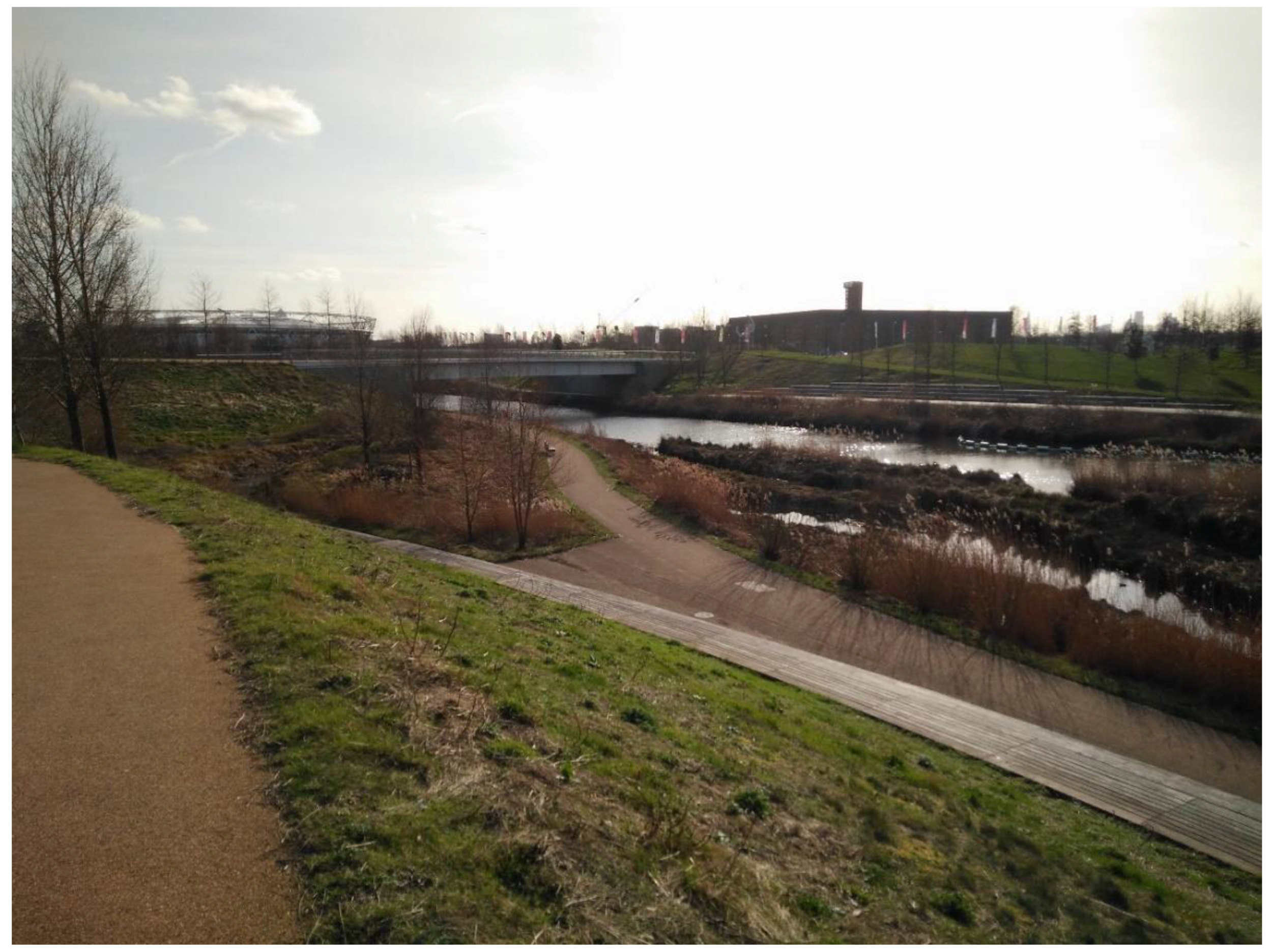
One can further provide evidence of a growing tendency for interdisciplinary design, specifically when interventions consider the need for climate change adaptation. One of the most recent examples of urban realm to have been created in light of the disseminated climate change projections is the Olympic Park (#75), or more precisely “Queen Elizabeth Olympic Park” in London (Figure 1). In brief, the Park’s landscape design priorities included “Great amenity; Improved micro-climate; Biodiversity; Integrated water management; Energy generation; Resource management; Waste management and minimization; Local food production; …” ([35], p. 1), among others. Priorities that involved the inclusion of additional and uncommon disciplines to be actively involved in the design process.
Among other challenges, the adaptation to new environments created by climate change requires a new integrated and interdisciplinary approach [36]. Solutions arising from interdisciplinary designs are very diverse and combine the use of a wide range of approaches such as technical, social, economic, ecological, among others. With regards to adaptation, there is much we can learn from our civilizational past, which has surpassed other great turbulences. We must also humbly accept that the impending future will require new outsets and new paradigms. New ideas that will most likely arise from a common effort of multiple, shared and applied expertise. Public spaces, as spaces that particularly favor interdisciplinary convergence, may serve to promote and explore technological reinventions or innovations. A continuing learning process that, in face of climate change, searches for new design solutions that increase adaptability and reduce vulnerability.
3.2. Multiple Purpose Public Space
All the examples highlighted in the presented table entail multiple purposes for the basic fact that all were gathered following the basic premise of being a public space with flood adaptation capacities, and as such already encompass both the purpose of being a common space for community encounters as well as an infrastructural space for the management of flood waters.
Indeed, the resulting combination of an interdisciplinary design that integrates flood adaptation functions with public space design offers side purposes among other sectorial needs such as recreation, microclimatic melioration or energy use and efficiency. The more interdisciplinary design is, the more adjacent functions the resulting public space will comprise.
Traditional drainage infrastructure, for instance, such as large-scale underground retention chambers disconnected from public space, is only useful occasionally during the year, namely during heavy rainfall. In contrast, other source control measures, such as green walls, bioretention basins or rain gardens, when applied within public spaces, may not only serve its prime infrastructural function, but may also serve to improve local environment and quality of life as well as vulnerability reduction and local awareness [37]. The side benefits that result from reconfiguring drainage infrastructure within public space design thus generally gathers recurring advantages all year long.
“The Circle”, in a Roundabout at Uptown Normal, Illinois (#26) serves to provide evidence of this argument. It is a green water square in a roundabout that collects, stores and purifies storm water runoff from the nearby streets. Besides the aesthetical and leisure characteristics, the water feature masks surrounding traffic noise while purified water is used to spray nearby streets and thus lessen heat stress [34]. The square is further used as a meeting place situated near a multimodal transportation centre and a children’s museum.
The previously mentioned ‘Queen Elizabeth Olympic Park’ in London (#75) is one other example of an interdisciplinary design that consequently embraced multiple purposes. That is namely the case of the included treatment process that turn Londoner’s wastewater from an outfall sewer into water suitable for irrigation, flushing toilets and as a coolant in the Park’s energy centre [38].
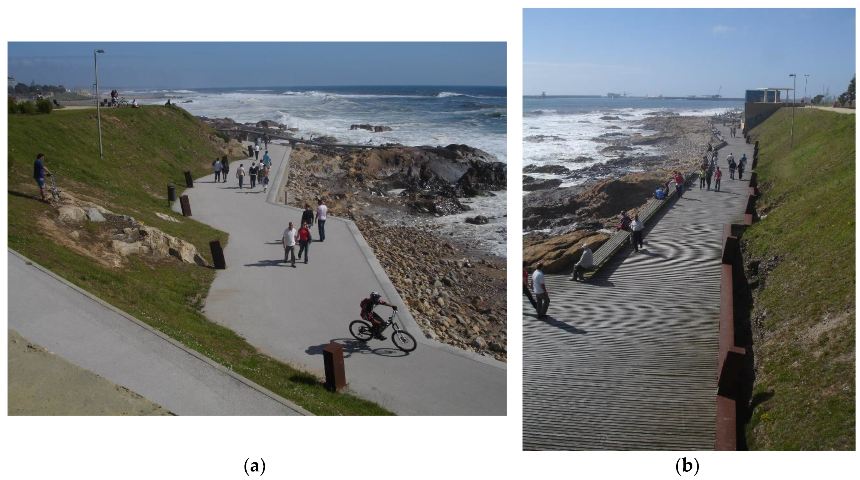
In addition, some breakwaters or wave-breakers, such as the one existing at the Zona de Banys del Fòrum in Barcelona (#99), are here understood as a multi-purpose public spaces, as they not only entail the infrastructural function to ease the power of waves but also include the possibility to be used as a sightseeing route—two encompassing functions that are additionally combined in a sculptural design that is aesthetically appealing (Figure 2).
3.3. Public Space for Actor’s Awareness and Engagement
Social and political engagements are a particularly important factor in the success of adaptation endeavors, namely when acknowledging that adaptation is a learning process of continued assessment. Indeed, benefits may be gained from a multifaceted approach that includes social enquiry and stakeholder engagement [39]. Moreover, community engagement may be reached through community involvement, emotional connection and a design that makes visible the invisible. When adaptation actions are applied within a public space, where design can make visible certain intangibles, endeavors are no longer an abstract phenomenon for people and communities. Community engagement practices in public space design and management gain, therefore, a new dimension.
Considering flood events, which are expected to increase in light of future climatic extremes, the roughly intangible water cycle can be made visible through design. Particularly through the design of public spaces that, due to their inherent values, provide the opportunity to approximate and connect people with water and thus potentially raise awareness and overall engagement. Indeed, as it is for Ashley et al., the challenge of appropriate drainage systems for a changing climate is as much sociological as it is technological [40].
The Benthemplein square (#18) (Figure 3) and Tanner Springs Park (#19) may serve as examples that corroborate the argument that public spaces are rarely “mute” and may serve to connect people with water. Both cases encompass the concept of a “water plaza” previously mentioned, which intentionally unveils part of the urban water cycle dynamics for the citizens that use that public space. As mentioned in the Rotterdam Climate Proof report “Water disarms and binds people. In adaptation projects in the city, citizens and different cultures come together. This can reinforce social ties and the sense of safety” ([41], p. 7).
In regard to the case of Tanner Springs Park in Portland, its design comprised the restoration of a wetland into the setting of an urban context. Inspired by the area’s original natural state, the park is composed of a pond at its lowest point, to which rainwater from the surroundings is conveyed. The design therefore combined several objectives among the fields of ecology, water management, art and participation. Some of its main characteristics include reintroduced groundwater, water features, appropriate vegetation and site-specific artwork that provides evidence of the biological beings from the former wetland.
To promote community engagement, it is further important to highlight the need to create places that people can value and connect emotionally too. Likewise, the success of community engagement processes is strongly related with the development and value of local identity. In this sense, the presence of water in urban design, and more specifically in the design of public spaces, has particular symbolic dimensions (emotional, aesthetic, and cultural) that should not be overlooked.
One of the oldest representations of water is Genesis’ description of the Garden of Eden and its four structuring rivers that give life to this mythical space ([42], Gn 2:10–14). However, as we are all aware of, water is not only the source of life, but it is also a permanent threat. In addition, the fear of water is also tattooed onto our civilizations worldwide. Genesis’s flood narrative in the Bible is one of many flood myths found in our cultures.
Water’s symbolic dimensions should therefore be enhanced in a public space design that aims to connect people with water. This exercise is particularly evident in the works of Atelier Dreiseitl, here represented by the examples #19, #22, #49, #61, #64, #73 and #76. Atelier Dreiseitl is an office that recurrently uses water beyond its decorative features. Through their designs, water is rather integrated with other systems and other functions, always bearing in mind the final purpose of aesthetic appreciation and public perception of the value of water as a resource.
Another way to promote community engagement on the urging need to adapt our urban spaces in the face of climate change is through direct community involvement and interaction—specifically because adaptation is not one in a lifetime project. On the contrary, adaptation processes require ongoing collaborations and organization between and among government, institutions and its citizens.
Greenfield Elementary in Philadelphia (#54) is a good example of the fruitful results that may arise from collaborative design among stakeholders. More specifically, parents, teachers, students, school administrators, designers from Community Design Collaborative and the Philadelphia School District. More importantly, the all planning stages of the project until its end result worked as a living laboratory that teaches anyone who passes by about overall features of environmental processes. The plan aimed to convert the school yard, used previously as a parking lot, into a green space with sustainable concerns. The improvements included the installation of a flood management system with indigenous vegetation, the removal of impervious pavement, a permeable recycled play surface, an agriculture zone as well as solar shading. A storm water bioretention area with a rain garden was also installed.
Communal management also occurred in New Orleans after the destruction and desolation of Hurricane Katrina. More precisely, an “extraordinary new level of civic and community engagement” ([43], p. 61) helped the city towards recovery and rebuilding, through a process that retained a strong connection to the cities’ history while also looking forward in addressing future challenges such as climate change.
In accordance with the report developed by the Institute for Sustainable Communities (ISC) in partnership with the Center for Clean Air Policy, the community embraced the idea that the best approach to endure future climatic extremes is to become a greener city that, consequently, promotes safety and enriches attractiveness for business and residents [43]. One of the implemented projects aimed to transform the constraint of having more than 60,000 vacant lost lots in the city, transforming some of them into a network of urban farms and public gardens.
Furthermore, it is important to provide evidence that, in New Orleans’ recovery, governments’ investments alone would have had a reduced impact. The city was able to recover, and it is able to take forward its strategic plans, because of a creative and energized community, because of public and private partnerships and because of a comprehensive cooperation among national and international experts [44].
3.4. Public Space as an Extensive Physical Structure and System
Reflecting upon the perception of public space as a structuring element of the urban form [5,6], additional reasons promptly lead to further conclude that these are particularly favorable places for the implementation of flood adaptation measures.
Public spaces have a fundamental role in city life as they enable formal and environmental continuity, accessibility and legibility, contributing to the reinforcement of social and economic centralities [45]. In the series of lectures “O Urbano e a Urbanística ou os tempos das formas” [46], Nuno Portas highlighted that, in the history of cities, public spaces are more durable than buildings; that buildings are stable elements, but not durable elements; and that, after public spaces, the most durable elements are the buildings that are transformed into monuments, i.e., transformed into public spaces. Indeed, public spaces are determinant elements in the form and identity of a city.
Public space, as a structuring layer of urban form, is organized in a systemic way, and can be seen as performing two complementary roles: as hardware, it provides a physical setting, making connections and furthering an infrastructural base for urban functions; as software, it incorporates relations and interactions that make urban life—a social-cultural dimension representing its society or community—as a space for expression and sharing. According to Borja, “The fact that public space is the determining element of the urban form is enough to attribute it the role of structurer of urbanism and, firstly, its urban fabric” ([2], p. 137, author’s translation). One can thus claim that public spaces are not only the means of social, economic and cultural dynamics, but are also a physical structuring element of the urban fabric. A structuring network that is able to construct a “recognizable and lasting image of an individual unity, which arises from a system of complementary parts, as various and as unorganized as they may be” ([6], p. 17, author’s translation).
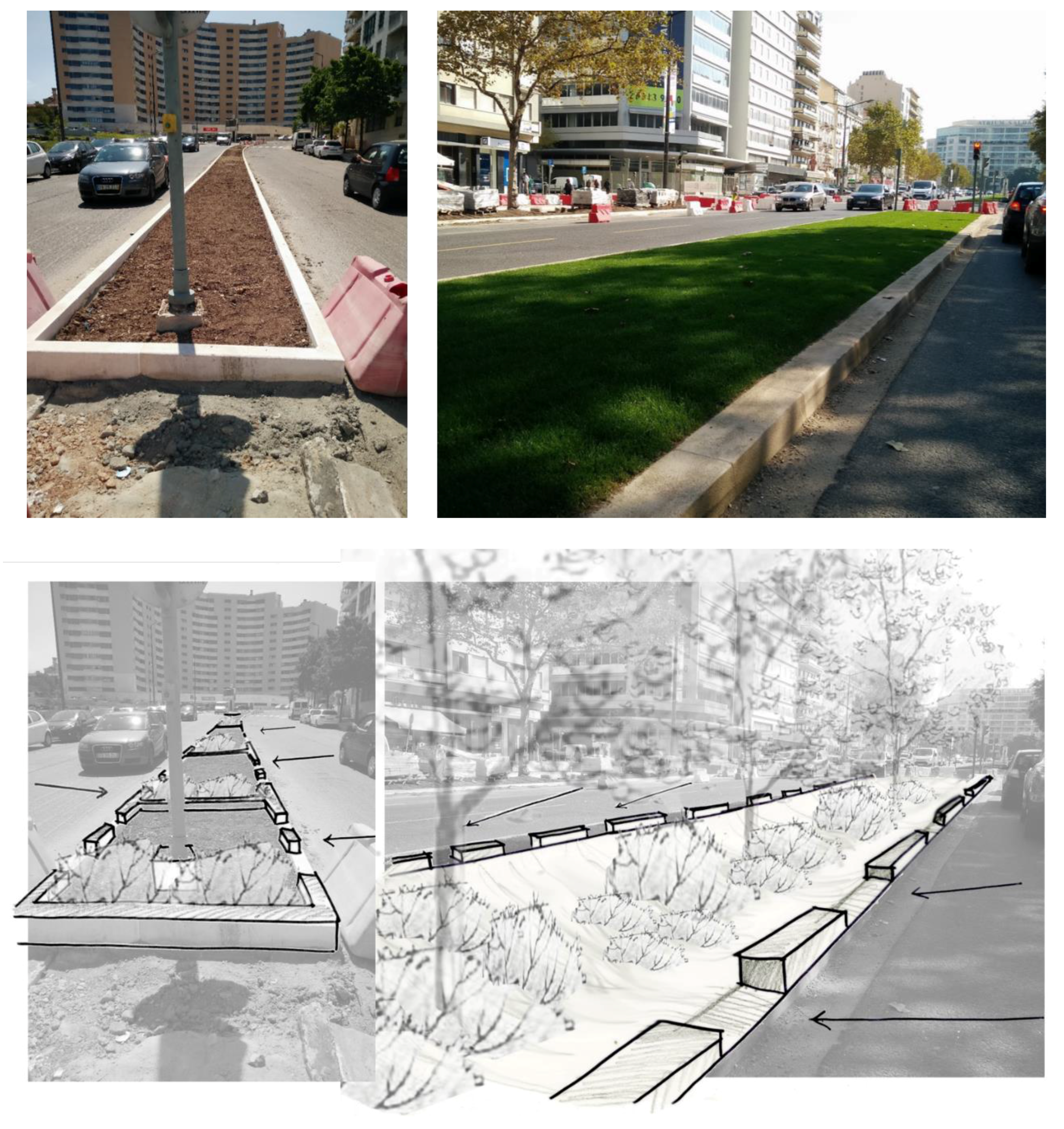
By conforming a structural network based on the local scale, public space offers a decentralized and expansive means to tackle flood management. An approach that strongly contrasts with the traditional method that tends to be linear and centralized. This distinction, together with an assessment of exploratory nature regarding the adaptation measure’s infrastructural efficiency, was particularly emphasized in the article “Urban Flood Adaptation through Public Space Retrofits: The Case of Lisbon (Portugal)” [37].
Moreover, public spaces offer a network that not only supports the urban fabric, but also connects its different urban spaces, from buildings and infrastructures to natural structures such as the ecological network. For Portas, this communicating network of public spaces “cannot be reduced to a simplistic addition of segments, unconnected streets, detached to the territories they cross, more or less urbanized” ([6], p. 17, author’s translation). In other words, public spaces must not be understood by its individual elements, but rather as a “coherent structure that encompasses different territorial scales (from the neighborhood to the metropolitan city)” ([47], p. 1). The same can be said about hydrographic basins and other structures that support dispersed urban settlements. Indeed, one of the main causes of urban floods is related to the manipulation of natural watersheds through forced interruptions or divisions into smaller parts. These approaches do not consider the fact that their effective functioning is highly dependable on a system that is comprehensive by nature.
It is therefore equitable to conceive water systems equally converged within the network of public spaces. One can easily identify episodes were water systems’ networks have met with public spaces. However, most of the time, it is an event that is neither planned nor wanted. Considering, for instance, drainage overflows resulting from heavy rainfall, in this situation, storm water generally flows along the next available spaces, generally “open” spaces and mostly public spaces. If this “encounter” could be looked upon through a different perspective, one that would capitalize from the inherent values of public space, the excess of water could be integrated within designs as an opportunity to potentiate a comprehensive adaptation in an extensive and decentralized network (Figure 4).
A representative undergoing example that takes advantage of the benefits offered by the extensive physical structure of public spaces is probably New York’s Green Infrastructure plan launched in 2010. In brief, this plan aimed to offer a more sustainable alternative to the conventional “grey” infrastructure by proposing integrated structure that combined solutions such as: rooftop detention, green roofs, subsurface detention and infiltration, swales; street trees, permeable pavement, rain gardens, engineered wetlands, among others.
While New York’s program is illustrated by the example of Elmhurst parking lot (#34), many other examples fit within its overall approach. More specifically, examples such as the bioretention planters on Ribblesdale Road in Nottingham, United Kingdom (#39), the open drainage system in Trabrennbahn Farmsen residential area in Hamburg (#33), Germany or the drainage systems of the Ecocity Augustenborg in Malmö, Sweden (#35).
The bioretention planters of Ribblesdale Road in Nottingham were a pilot retrofit project of sustainable urban drainage. They were therefore created for its design and construction to be documented and evaluated in order to assess its comprehensive application. A total of 148 m2 of bioretention planters were implemented within an existing urban road setting. Among the main objectives of this intervention, it is worth mentioning the following: (1) maximize surface water interception, attenuation and infiltration; (2) encourage participation from local residents in the design and future management of the rain gardens; and (3) evaluate the effectiveness of the scheme as an engagement tool around the sources of urban diffuse pollution and flood risk [48].
Trabrennbahn Farmsen is an example of a newly built residential area that comprised the application of a particularly interesting open drainage system. Because its implementation area has little infiltration capacity, designers chose to implement an open water system that would retain and convey rainwater. In accordance, storm water is collected from surrounding streets as well as from the building’s roofs. Overall, the system is composed of grassed swales, storm water channels and two retention ponds [49]. The greatest highlight of this example is the autonomy of this natural system to manage all storm water from the Trabrennbahn Farmsen residential area on-site, providing evidence of a reduced importance of underground sewers for rainwater.
3.5. Expose and Share Value through Public Space
By integrating infrastructure in the design of a public space, instead of camouflaging it underground or in an isolated impenetrable area, a public investment is exposed and shared with a community. A shared value that may instigate further opportunities such as amenity or environmental quality. For example, while in the common mainstream urban drainage approach investments are camouflaged underground, frequently encompassing a sole function and use for storm water alone; investments on urban drainage could be applied in infrastructure that is integrated within the public space itself. In the second option, value is not only exposed to all, but also shared among everyone using that space. Sustainable Urban Drainage systems (SUDs) clearly illustrate and make the case.
Through dispersed, yet extensive, small-scale investments within public space design, urban amenities may be further created while taking advantage of ecological and economic opportunities along the way. While buried culverts may be a missed opportunity for the enhancement of the quality of public space, obsolete and no longer necessary flood walls may likewise hide valuable water assets [50]. Indeed, there are many opportunities for infrastructure renovation and necessary landscape improvements throughout urban areas: from the need to provide alternatives to reduce the load of obsolete drainage infrastructure to vacant lots that can be used to store water. Bearing in mind the ever exceeding costs of traditional infrastructure repair alongside expected climate change extreme projections, a wide range of literature argues that established methods are no longer affordable nor sustainable, such as [51,52,53]. As such, new alternatives, supportive of an integrated water management, should be considered not only as a necessary immediate investment, but, more importantly, as an investment in our future.
Uncovering small scale storm water drainage systems, such as in Banyoles, Girona (#70) or in the 13th century Freiburg Bächle (#71), is one way of exposing and sharing the expressed value of water in an urban environment.
In brief, the regeneration of the old city center of Banyoles, designed by Miàs Arquitectes, envisaged two main purposes: (1) to repave the town center and define a new pedestrian area and (2) to reclaim the irrigation canals that used to feed medieval private gardens. These waterways used to run in open channels from the lake and throughout the town. With the loss of these gardens, the canals were progressively covered and water quality worsened. The resulting public space offers a new main square and adjoining streets composed by linear travertine paving stones that are “cut-off” by open channels, which undercover the presence of the water.
Projects that “bring into light” buried pre-existing water lines are another example of adaptation measures that aim to expose and share value. This is the case of Westersingel channel (#66) and the Soestbach River neat Soest (#69), besides the representative example of the Cheonggyecheon river (#68) previously analyzed.
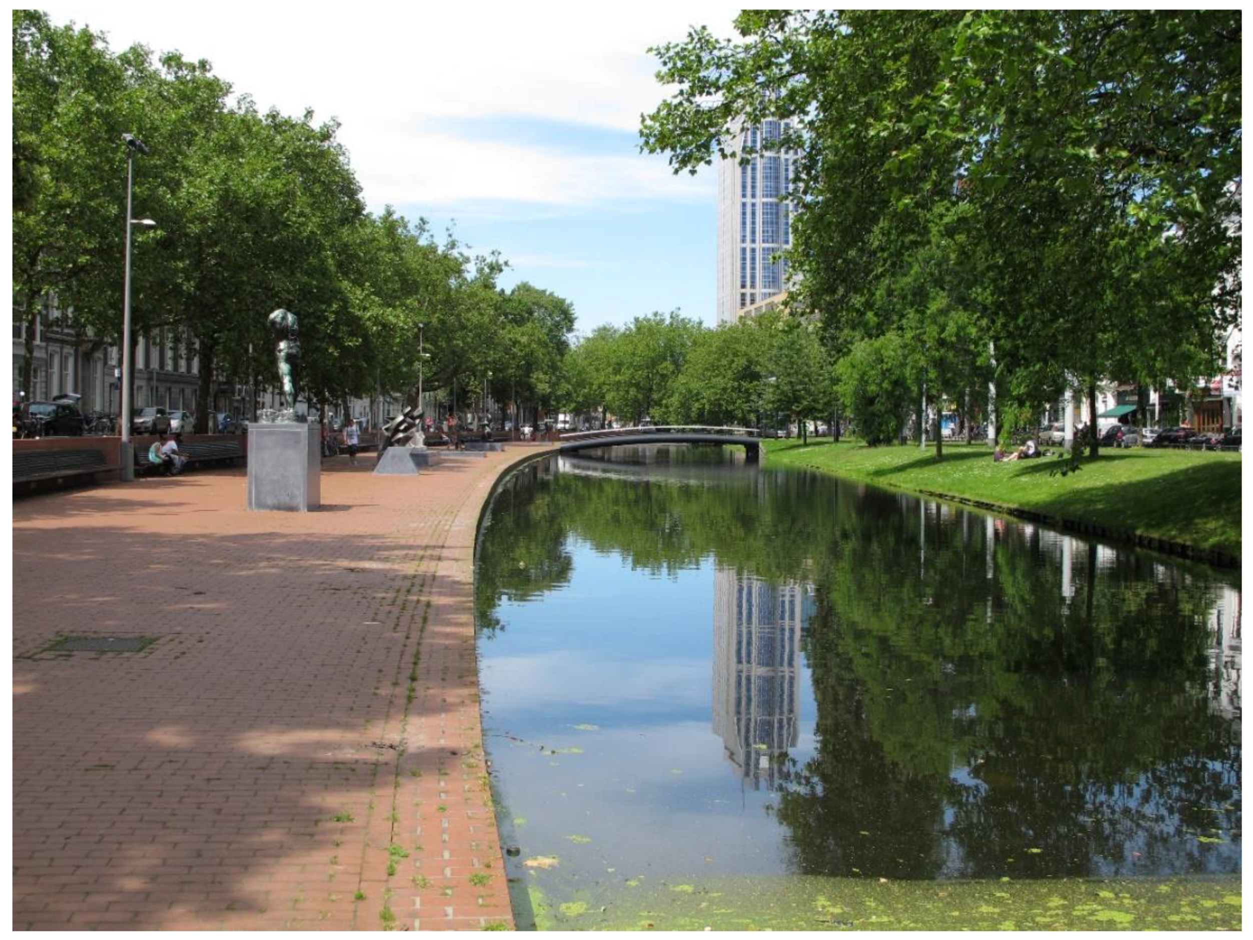
Rotterdam’s Westersingel channel, which had been formerly sunken, was redesigned by Dirk van Peijpe from the De Urbanisten office. The resulting promenade almost disguises its capacity to sustain and retain excesses of water when needed (Figure 5). Its banks are mostly made of brick as well as grass and trees. All materials, including urban equipment such as benches and lamps, are designed to endure occasional overloads of the canal. Currently, this public space is enriched with sculptures by well-known artists such as Rodin, Carel Visser, Joel Shapiro and Umberto Mastroianni.
3.6. Public Spaces as a Means to Diversify and Monitor Flood Risk
According to the Intergovernmental Panel on Climate Change (IPCC), “The main challenge for local adaptation to climate extremes is to apply a balanced portfolio of approaches, as a one-size-fits-all strategy may prove limiting for some places and stakeholders” ([54], p. 291). In other words, in light of climate change, the sole investment in one isolated infrastructure is not recommended, built to fulfill only its particular purpose. If plan A fails, the risk will be great and generalized. However, if investments are diversified, risk is dissipated through the reliance on parallel plans.
In addition, when massive infrastructures are kept out of site, people do not remember their existence and thus will not expect their failure. This unpreparedness, led by a false sense of safety that is usually termed “levee-effect”, may further exacerbate vulnerability and increment potential impacts. Contrastingly, if approaches are implemented within public spaces, some risks are more closely acknowledged and thus less unexpected.
Regardless, research aimed at analyzing the social construction of risk or social risk perception is rather complex. As made evident by Sergi Valera [55], social theories of risk namely suggest that the causes and consequences of risk are mediated by the subjective criteria of individual processes (or psychological), social (psychosocial) behaviors and culture. The same way the design of a public space may reduce or exacerbate a risk through “rational and scientific” processes, it may also reduce or exacerbate the perception of that risk through “subjective-social” processes. It is further important to note that the social construction of a risk may influence the degree of the risk itself, minimizing or maximizing it. Risk perception is thus a very important factor that must be taken into consideration, namely in the design process of a public space with flood adaptation purposes, so that the resulting outcome does not contradict the initial purpose.
As argued by Evers, Höllermann et al., one must focus on a pluralistic approach in order to incorporate Human–Water relations [56]. Through the diversification of risk, by investing in more than one great mono-functional strategy, the communal management among government, institutions, communities and private companies is also promoted; unlike traditional management that is essentially based on government’s actions on behalf of communities. As a result of communal management, risk is further shared and communities are more likely involved in the management and monitoring of implemented infrastructures. In addition, local knowhow is explored, citizens are empowered to act before the need for safety and the identity of vulnerable places is reinforced.
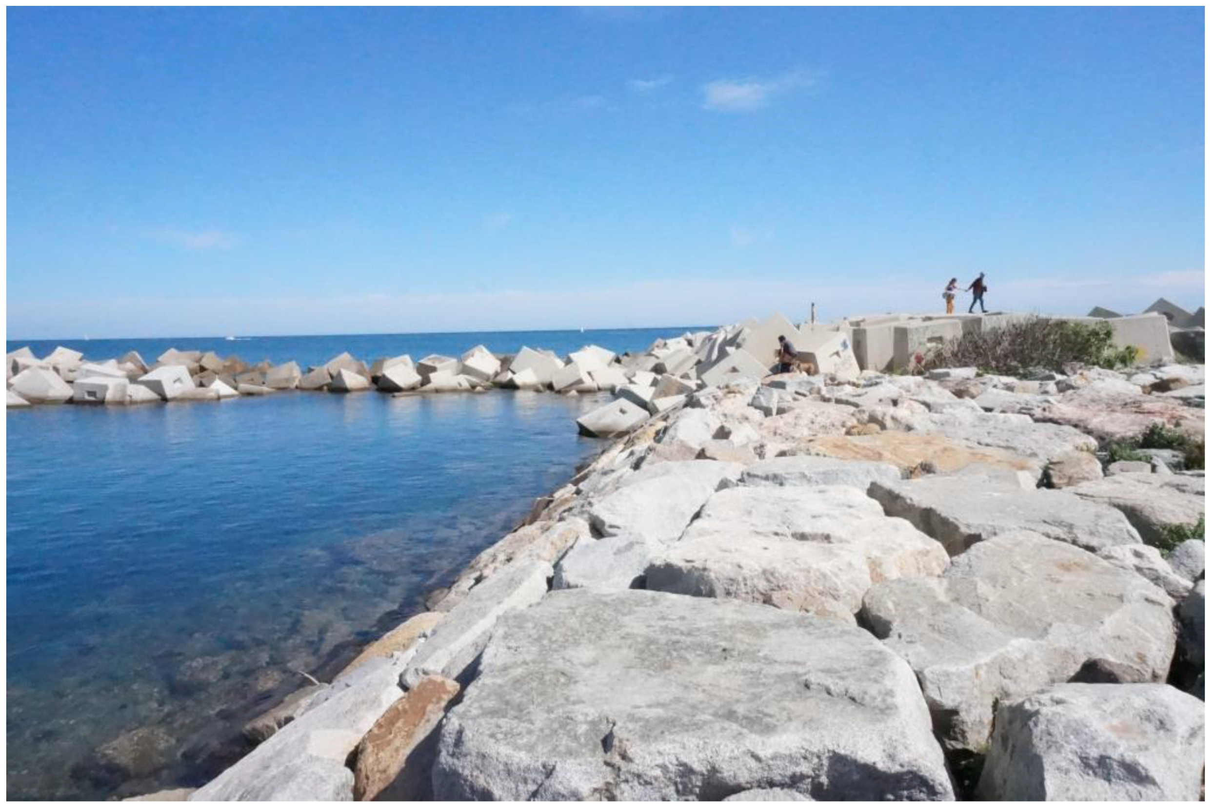
One illustrative example is the Passeio Atlântico at Porto designed by Manuel de Solà-Morales and others. This submergible pathway, which develops between Montevideu Avenue and the Atlantic coast, encompassing both submergible boardwalks as well as submergible concrete pathways, demonstrates how a storm surge defense slope, may be integrated within the design of a multifunctional public space (Figure 6).
Through this project, people are more connected to the intense coastal water dynamics and thus more aware of its nature. By sharing the value of the infrastructure through its common use as a public space, not only is the awareness of the power of nature promoted, but also a certain sense of responsibility and appropriation is reinforced. While the first aspect may lead to the respect and willingness to adapt, the second aspect may lead to active management and monitoring of the infrastructure itself.
Comprised of three levels of parallel and undulating waterfront boulevard, this space offers more than its functional requirement to protect The Hauge from coastal floods. More specifically, it articulates other programs such as coastal life and recreation (bars and restaurants), public and private circulation (bicycles and cars) and connections with the urban fabric [57].
4. Discussion
While the most attractive adaptation strategies are usually those that offer development benefits in the short term and reductions of vulnerabilities in the long term, extensive literature has been highlighting that not all adaptation responses are benign. Among others, the IPCC in its report “Managing the Risks of Extreme Events and Disasters to Advance Climate Change Adaptation” states that “there are trade-offs, potentials for negative outcomes, competing interests, different types of knowledge, and winners and losers inherent in adaptation responses” ([58], p. 443). Selecting the optimal adaptation strategy or measure for a particular situation is therefore neither easy nor straightforward. This determining process is particularly complicated given the specific ramifications and secondary impacts related to adaptation processes. In some cases, results can be critical, namely when adaptation does not fulfil its designated objective and ultimately leads to increased vulnerability. This phenomenon is generally called Maladaptation, which can be described as “action taken ostensibly to avoid or reduce vulnerability to climate change that impacts adversely on, or increases the vulnerability of other systems, sectors or social groups” ([59], p. 211). For example, a bioswale with the right combination of phytopurification plants that are placed in the wrong location, may not only be an unnecessary expenditure, a lesser effect is that they may give rise to stagnant water that can be very dangerous to public health (namely through exposed untreated contaminants and mosquito breeding).
However, maladaptation cannot be considered as a hindering factor supporting “business as usual” as uncertainties can be minimized through the ongoing adjustments of continuous assessment. Facing an unprecedented area of action, concepts, paradigms or structures are expected to change overtime, as are the functions, appearance and complexities of public spaces with flood adaptation measures. The design of these spaces must therefore encompass an ongoing process that is fundamentally grounded on the need to learn, reflecting upon mistakes and generating experience while dealing with change [60]. In the words of Jordi Borja, today we must “Accept the challenges with the intent to provide answers and with the modesty of providing them with uncertainty, with the audacity to experiment and with the humility to admit mistakes” ([2], p. 140, author’s translation).
It is furthermore essential to highlight that, while the analyzed initiatives have counterbalanced the inevitable uncertainties of global models and the generalized “top-down” policies, local action must be connected to the global scientific findings and its encompassing strategies. Otherwise, applied adaptation measures may get lost in scale, lose its value, and thus fail its purpose. While local scale action is presently acknowledged as a fundamental element for effective urban climate change adaptation, its greater challenge therefore relies on finding the balance and exploring the benefits from the arising synergies between local collective actions and national and international strategies. The same way local adaptation strategies must not be dissociated from global adaptation strategies, so too do the processes of public space design, which must follow objectives and strategies of regional and national levels, otherwise “…actions will not contribute, in an effective way, to the achievement of community expectations in the safeguard public interests and collective resources” ([26], p. 19, author’s translation). Through the inclusion of flood adaptation measures within public space design, new challenges arise before contemporary urbanism and urban design practices. Likewise, although this research is specifically focused upon adaptation measures applied in public spaces, there are several other areas of opportunity that may additionally provide significant contributions in the development of flood adapted cities. More specifically, disciplines such as building design, governance or landscape architecture have been extending their literature regarding this specific subject matter, suggesting further developments namely on floating buildings, transdisciplinary and transboundary consortiums or in blue and green corridors.
Sustained by an empirical analysis based on specific examples, this article emphasizes the particular advantages offered by public space itself as a means where flood adaptation measures can be implemented. However, it is important to note that the presented findings are unintended to serve as restrictive boundaries. It is not here advocated that flood adaptation endeavors can only be considered as such if comprising all the mentioned potential advantages offered by public space, nor that they are only successful if comprising all these mentioned advantages. What is argued is that the above-mentioned characteristics are only potential and are considered as an additional asset either alone or combined. Ultimately, it is reasoned that public space is an ideal interface for adaptation action. Consequently, it is further questioned whether the evaluation of adaptation initiatives should consider: (1) if the design of a public space comprises adaptation measures and, on a reverse perspective, (2) if the application of adaptation measures comprises the design of a public space.
Nuno Portas in [61] reflected about different phases of urban projects that have led to different ways on how public spaces were produced. In the described first phase, most interventions were held in heritage areas, entailing projects such as the pedestrianisation of historic centers or creation of public spaces as a replacement of old industrial uses. The second phase entailed urban projects that were induced by events such as the Olympic Games, Capital of Culture or International Exhibitions. These projects had in common the aim to generate new facilities suited for leisure, culture or sports as flag/brand attracting projects. Proposing a further prospective discussion, a final question arises: are we at the fringe of a third phase, in which, in a changing climate, urban projects of diverse territorial nature will also aim to produce public spaces that are prepared to adapt to future impending weather events?
5. Conclusions
Within the multi-scaled scope of adaptation action, local scale, from the bottom-up, adaptation is particularly relevant, not only because it very likely influences global climate, but also because it entails immediate repercussions on the reduction of society’s vulnerability. Not only are hazards more acutely felt at the local level, but it is also within local communities that have the most know-how and experience to promptly deal with existing vulnerabilities. Competent and politically autonomous municipalities that are close with its citizens are therefore more likely to conduct effective adaptation action with wide ranging positive repercussions. In this line of reasoning, and bearing in mind the particular advantages of local scale adaptation, it is argued that the quality of our future cities will be influenced by the quality of future adaptation measures in public spaces.
Public space enables and promotes community life. It further potentially offers wide-ranging benefits such as place-making, sense of place or local identity. As a civic space, with communal and shared, a new variety of insurgent citizenship is arising within public spaces as the urgent matter of climate change adaptation is now broadly recognized. Furthermore, as emphasized, social, cultural and emotional factors can be more valued and respected within a community than the need of physical safety or ecological services.
Through public spaces and public space design, local climate change can be made visible and consequently meaningful for citizens and their livelihoods. Public spaces additionally provide a different source of knowledge and information, besides the mainstreamed sources of science and media, which may be apprehended an autonomous and independent process. Accordingly, public spaces provide extended opportunities for experiential learning inherent to adaptation processes.
In this line of reasoning, the design of public space sees itself enhanced in the face of impending weather events, being considered as a key factor in the adaptation of urban territories when facing climate change, and flood events in particular.
The examples here evidenced enabled the reasoning that, besides providing the means to include flood adaptation features, public spaces per se entail further specific connotations that are advantageous in adaptation endeavors. As evidenced by the analyzed examples, potential benefits may specifically arise from the characteristics of public space to:
- –
- Favor interdisciplinary design—in places founded through interdisciplinary means, innovative thinking more easily emerges;
- –
- Embrace multiple purposes—by combining flood adaptation measures with public space design, adjacent purposes arise among other sectorial needs such as water depuration, recreation or microclimatic melioration;
- –
- Promote community awareness and engagement—by engaging the community in the design and use of a public space, not only awareness about climate change may be promoted but also the self-determining willingness for adaptation action is enhanced.
- –
- Be supported by an extensive physical structure and system—by conforming a communicating structural network, public space offers the advantage of a decentralized and expansive means to tackle flood management;
- –
- Expose and share value—by integrating flood management infrastructure in a public space design, instead of camouflaging it underground or in an isolated impenetrable area, a public investment is exposed and shared. A shared value that may instigate further opportunities such as amenity or environmental improvements.
- –
- Promote risk diversification and communal monitoring—by investing in flood adaption measures applied in public space in addition to the conventional approaches, risk is dissipated and diversified and thus reduced. Moreover, through the diversification of risk, communal management among varied stakeholders is promoted. This way, communities are more involved, and the sense of responsibility and appropriation is stimulated, thus potentially leading to autonomous management and monitoring of shared implemented infrastructures.
People and communities can thus be perceived as more than susceptible targets and rather be professed as active agents in the process of managing urban vulnerability; climate change literacy, through the design of a public space, may endorse an increased common need for action and the pursuit of suitable solutions; and local know-how and locally-driven design can be considered as an added value for adaptation endeavors.
Acknowledgments
This research was supported by the Portuguese Foundation for Science and Technology funded by ‘Quadro de Referência Estratégico Nacional—Programa Operacional Potencial Humano (QREN–POPH), Tipologia 4.1–Formação Avançada, comparticipado pelo Fundo Social Europeu e por fundos nacionais do Ministério da Ciência, Tecnologia e Ensino Superior (MCTES)’, under the research project (CIAUD_UID/EAT/04008/2013) from the Research Centre for Architecture, Urbanism and Design (CIAUD), University of Lisbon, Portugal.
Author Contributions
Maria Matos Silva conceived and designed the research concept, research questions, data collection, data analysis, writing the manuscript and selecting the references. João Pedro Costa contributed to results analysis. The disclosed article introduces content that is developed in the doctoral thesis of Maria Matos Silva, with the title “Public space design and flooding: facing the challenges presented by climate change”.
Conflicts of Interest
The authors declare no conflict of interest. The founding sponsors had no role in the design of the study; in the collection, analyses, or interpretation of data; in the writing of the manuscript, and in the decision to publish the results.
References
- Innerarity, D. El Nuevo Espacio Público; Espasa Calpe: Madrid, Spain, 2006. (In Spanish) [Google Scholar]
- Borja, J. La Ciudad Conquistada; Alianza Editorial: Madrid, Spain, 2003. (In Spanish) [Google Scholar]
- Cowan, R. The Dictionary of Urbanism; Streetwise Press: Chicago, IL, USA, 2005. [Google Scholar]
- Ricart, N.; Remesar, A. Reflexiones Sobre el Espacio Publico. 2013. Available online: http://repositorio.pucp.edu.pe/index/bitstream/handle/123456789/11961/reflexiones_espacio_Saenz.pdf?sequence=1&isAllowed=y (accessed on 8 February 2018). (In Spanish).
- Martin, L. The grid as generator. In Urban Design Reader; Carmona, M., Tiesdell, S., Eds.; Architectural Press: Oxford, UK, 2007; pp. 70–82. [Google Scholar]
- Portas, N. Espaço público e a cidade emergente-os novos desafios. In Design de Espaço Público: Deslocação e Proximidade; Brandão, P., Remesar, A., Eds.; Centro Português de Design: Lisboa, Portugal, 2003; pp. 16–19. (In Portuguese) [Google Scholar]
- Madanipour, A. Ambiguities of urban design. Town Plan. Rev. 1997, 68, 363–383. [Google Scholar] [CrossRef]
- Brandão, P. Tica e Profissões, no Design Urbano. Convicção, Responsabilidade e Interdisciplinaridade. Traços da Identidade Profissional no Desenho da Cidade; Universitat de Barcelona: Barcelona, Spain, 2004; Available online: http://hdl.handle.net/2445/35424 (accessed on 7 September 2010).
- Arendt, H. The Human Condition, 2nd ed.; University of Chicago Press: Chicago, IL, USA, 1998. [Google Scholar]
- Costa, J.P.; Sousa, J.F.D.; Matos Silva, M.; Nouri, A. Climate change adaptation and urbanism: A developing agenda for lisbon within the twenty-first century. Urban Des. Int. 2014, 19, 77–91. [Google Scholar] [CrossRef]
- Matos Silva, M. Public Space Design for Flooding: Facing the Challenges Presented by Climate Change Adaptation. Ph.D. Thesis, Universitat de Barcelona, Barcelona, Spain, 2016. [Google Scholar]
- Jacobs, J. The Death and Life of Great American Cities; Random House: New York, NY, USA, 1992; 458p. [Google Scholar]
- Pedro Brandão (Coordinator). Research Project “Psss—public space service system” ptdc/ecm-urb/2162/2014. Funded by FEDER through the Operational Competitiveness Programme-COMPETE and by National Funds through FCT-Portuguese Foundation for Science and Technology: Universidade de Lisboa, Instituto Superior Técnico, CERIS, Investigação e Inovação em Engenharia Civil para a Sustentabilidade, 2016.
- Fletcher, T.D.; Shuster, W.; Hunt, W.F.; Ashley, R.; Butler, D.; Arthur, S.; Trowsdale, S.; Barraud, S.; Semadeni-Davies, A.; Bertrand-Krajewski, J.L.; et al. Suds, lid, bmps, wsud and more—The evolution and application of terminology surrounding urban drainage. Urban Water J. 2015, 12, 525–542. [Google Scholar] [CrossRef]
- Brandão, P.; Brandão, A.; Ferreira, A.; Travasso, N.; Remesar, A. What Is Public Space’s Service Value? Some Relevant Research Questions. Available online: http://aesop2017.pt/images/Congresso/proceedings/Book of Proceedings 20170926.pdf (accessed on 7 December 2017).
- Pelling, M. What determines vulnerability to floods; a case study in georgetown, guyana. Environ. Urban. 1997, 9, 203–226. [Google Scholar] [CrossRef]
- Beck, U. Risk Society: Towards a New Modernity; SAGE Publications: Thousand Oaks, CA, USA, 1992. [Google Scholar]
- Intergovernmental Panel on Climate Change (IPCC). Summary for Policymakers. In Climate Change 2014: Impacts, Adaptation, and Vulnerability. Part A: Global and Sectoral Aspects; Contribution of Working Group Ii to the Fifth Assessment Report of the Intergovernmental Panel on Climate Change; Cambridge University Press: Cambridge, UK; New York, NY, USA, 2014; 32p. [Google Scholar]
- Couzin, J. Living in the danger zone. Science 2008, 319, 748–749. [Google Scholar] [CrossRef] [PubMed]
- Biesbroek, G.R. Challenging Barriers in the Governance of Climate Change Adaptation; Wageningen University: Wageningen, The Netherlands, 2014. [Google Scholar]
- Van Der Linden, S. Towards a new model for communicating climate change. In Understanding and Governing Sustainable Tourism Mobility: Psychological and Behavioural Approaches; Cohen, S.A., Higham, J.E.S., Stefan, G., Peeters, P., Eds.; Routledge, Taylor and Francis Group: Oxfordshire, UK, 2014; pp. 243–275. [Google Scholar]
- Commission for Architecture and the Built Environment (CABE). Public Space Lessons—Adapting Public Space to Climate Change; CABE Space: London, UK, 2008; 8p. [Google Scholar]
- Matos Silva, M.; Costa, J. Flood adaptation measures applicable in the design of urban public spaces: Proposal for a conceptual framework. Water 2016, 8, 284. [Google Scholar] [CrossRef]
- Howe, C.; Mitchell, C. Water Sensitive Cities; IWA Publishing: London, UK, 2012. [Google Scholar]
- Trip, J.J. What Makes a City? Planning for 'Quality of Place'. The Case of High-Speed Train Station Area Redevelopment; IOS Press: Amsterdam, The Netherlands; Delft University Press: Delft, The Netherlands, 2007. [Google Scholar]
- Brandão, P.; Carrelo, M.; Águas, S. O Chão da Cidade. Guia de Avaliação do Design de Espaço Publico; Centro Português de Design: Lisboa, Portugal, 2002; 199p. (In Portuguese) [Google Scholar]
- Brandão, P. O Sentido da Cidade. Ensaios Sobre o Mito da Imagem Como Arquitectura; Livros Horizonte: Lisboa, Portugal, 2011. (In Portuguese) [Google Scholar]
- Nouri, A.S.; Matos Silva, M. Climate change adaptation and strategies: An overview. In Green Design, Materials and Manufacturing Processes; Bártolo, H., Bartolo, P.J.D., Alves, N.M.F., Mateus, A.J., Almeida, H.A., Lemos, A.C.S., Craveiro, F., Ramos, C., Reis, I., Durão, L., et al., Eds.; Taylor and Francis: Lisbon, Portugal, 2013; pp. 501–507. [Google Scholar]
- Brandão, P. La Imagen de la Ciudad: Estrategias de Identidad y Comunicación; Publicacions i Edicions de la Universitat de Barcelona: Barcelona, Spain, 2011. (In Spanish) [Google Scholar]
- Brandão, P. Entrevista. ArqA—Arquitectura e Arte; Novas Colectividades: Lisboa, Portugal, 2013; pp. 28–30. [Google Scholar]
- Capel, H. El Modelo Barcelona: Un Examen Crítico; Ediciones del Serbal: Barcelona, Spain, 2005. (In Spanish) [Google Scholar]
- Zaitzevsky, C. The “emerald necklace”: An historic perspective. In Emerald Necklace Parks: Master Plan; Walmsley, T., Pressley, M., Eds.; Commonwealth of Massachusetts, Department of Environmental Management: Boston, MA, USA, 2001; pp. 27–42. [Google Scholar]
- Matos Silva, M. El Modelo Barcelona de Espacio Público y Diseño Urbano: Public Space and Flood Management/Dipòsits D’aigües Pluvials. Universitat de Barcelona: Spain, 2011. Available online: http://hdl.handle.net/2445/17762 (accessed on 8 February 2018).
- Pötz, H.; Bleuzé, P. Urban Green-Blue Grids for Sustainable and Dynamic Cities; Coop for Life: Delft, The Netherlands, 2012. [Google Scholar]
- London Legacy Development Corporation (LLDC). Landscaping the Park. Available online: http://queenelizabetholympicpark.co.uk/ (accessed on 22 January 2016).
- Malano, H.; Maheshwari, B.; Singh, V.P.; Purohit, R.; Amerasinghe, P. Challenges and opportunities for peri-urban futures. In The Security of Water, Food, Energy and Liveability of Cities: Challenges and Opportunities for Peri-Urban Futures; Maheshwari, B., Purohit, R., Malano, H., Singh, V.P., Amerasinghe, P., Eds.; Springer: Dordrecht, The Netherlands, 2014; pp. 3–10. [Google Scholar]
- Matos Silva, M.; Costa, J.P. Urban flood adaptation through public space retrofits: The case of lisbon (portugal). Sustainability 2017, 9, 816. [Google Scholar] [CrossRef]
- European Environment Agency (EEA). Towards Efficient Use of Water Resources in Europe; Report No. 1/2012; European Environment Agency: Copenhagen, Denmark, 2012; 70p. [Google Scholar]
- Sharma, A.; Pezzaniti, D.; Myers, B.; Cook, S.; Tjandraatmadja, G.; Chacko, P.; Chavoshi, S.; Kemp, D.; Leonard, R.; Koth, B.; et al. Water sensitive urban design: An investigation of current systems, implementation drivers, community perceptions and potential to supplement urban water services. Water 2016, 8, 272. [Google Scholar] [CrossRef]
- Ashley, R.M.; Faram, M.G.; Chatfield, P.R.; Gersonius, B.; Andoh, R.Y.G. Appropriate drainage systems for a changing climate in the water sensitive city. In Low Impact Development 2010: Redefining Water in the City; ASCE: Listeria, VA, USA, 2010. [Google Scholar]
- Rotterdam Climate Initiative (RCI). Rotterdam Climate Proof Adaptation Programme. The Rotterdam Challenge on Water and Climate Adaptation; Rotterdam Climate Initiative: City of Rotterdam, The Netherlands, 2009; 22p. [Google Scholar]
- Bíblia Sagrada, 5th ed.; Difusora Bíblica: Lisboa, Portugal, 1991. (in Portuguese)
- Institute for Sustainable Communities (ISC). Promising Practices in Adaptation & Resilience. A Resource Guide for Local Leaders; Institute for Sustainable Communities, Produced in Partnership with Center for Clean Air Policy: Washington, DC, USA, 2010; 98p. [Google Scholar]
- Dutch Dialogues. About Dutch ‘Dialogues’. Available online: www.dutchdialogues.com (accessed on 2 April 2011).
- Pinto, A.J. Coesão Urbana: O Papel das Redes de Espaço Público. Universitat de Barcelona: Spain, 2015. Available online: http://hdl.handle.net/2445/67852 (accessed on 5 April 2011). (In Portuguese).
- Portas, N. O urbano e a Urbanística ou os Tempos das Formas. Available online: http://www.culturgest.pt/actual/01/01-nunoportas.html (accessed on 29 January 2012).
- Pinto, A.J.; Remesar, A.; Brandão, P. Networks and Anchors: From Morphology to the Strategy of Urban Cohesion. In Proceedings of the 1st Conference of the Portuguese Network of Urban Morphology “Urban Morphology in Portugal: Approaches and Perspectives”, Lisbon, Portugal, 8 June 2011; International Seminar on Urban Form, Ed.; pp. 1–3. [Google Scholar]
- Susdrain. Susdrain Case Studies. Available online: http://www.susdrain.org/case-studies (accessed on 14 April 2016).
- Howe, C.A.; Butterworth, J.; Smout, I.K.; Duffy, A.M.; Vairavamoorthy, K. Sustainable Water Management in the City of the Future; Findings from the SWITCH Project 2006–2011, Ed.; UNESCO-IHE: Delft, The Netherlands, 2011. [Google Scholar]
- Papacharalambous, M.; Davis, M.S.; Marshall, W.; Weems, P.; Rothenberg, R. Greater New Orleans Urban Water Plan: Implementation; Waggonner & Ball Architects: New Orleans, LA, USA, 2013; 225p. [Google Scholar]
- White, I.; Howe, J. The mismanagement of surface water. Appl. Geogr. 2004, 24, 261–280. [Google Scholar] [CrossRef]
- Hartmann, T.; Driessen, P. The flood risk management plan: Towards spatial water governance. J. Flood Risk Manag. 2013, 1–10. [Google Scholar] [CrossRef]
- Lennon, M.; Scott, M.; O’Neill, E. Urban design and adapting to flood risk: The role of green infrastructure. J. Urban Des. 2014, 19, 745–758. [Google Scholar] [CrossRef]
- Intergovernmental Panel on Climate Change (IPCC). Managing the Risks of Extreme Events and Disasters to Advance Climate Change Adaptation; Cambridge University Press: Cambridge, UK; New York, NY, USA, 2012; 582p. [Google Scholar]
- Valera, S. La percepció del risc. In Com “Sentim” el Risc; Mir, N., Ed.; Beta Editorial: Barcelona, Spain, 2001; pp. 235–261. [Google Scholar]
- Evers, M.; Höllermann, B.; Almoradie, A.; Garcia Santos, G.; Taft, L. The pluralistic water research concept: A new human-water system research approach. Water 2017, 9, 933. [Google Scholar] [CrossRef]
- Solà-Morales, M.D. Scheveningen Den Haag, 2006–2012. Available online: http://manueldesola-morales.com (accessed on 26 January 2016).
- Intergovernmental Panel on Climate Change (IPCC). Managing the Risks of Extreme Events and Disasters to Advance Climate Change Adaptation—Summary for Policymakers; IPCC: Cambridge, UK; New York, NY, USA, 2012; 19p. [Google Scholar]
- Barnett, J.; O’Neill, S. Maladaptation. Glob. Environ. Chang. 2010, 20, 211–213. [Google Scholar] [CrossRef]
- Berkes, F.; Colding, J.; Folke, C. Navigating Social-Ecological Systems. Building Resilience for Complexity and Change; Cambridge University Press: Cambridge, UK, 2003. [Google Scholar]
- Brandão, P.; Remesar, A. Design de Espaço Público: Deslocação e Proximidade; Centro Português de Design: Lisboa, Portugal, 2003. [Google Scholar]
Figure 1.
Olympic Park, London. Image credits: Maria Matos Silva, 2 March 2017.

Figure 2.
Wave-breakers designed by Beth Gali, Architect, at the Zona de Banys del Fòrum in Barcelona. Image credits: Maria Matos Silva, 26 April 2014.
Figure 2.
Wave-breakers designed by Beth Gali, Architect, at the Zona de Banys del Fòrum in Barcelona. Image credits: Maria Matos Silva, 26 April 2014.

Figure 3.
Benthemplein square, Rotterdam. Image credits: Maria Matos Silva, 14 June 2014.

Figure 4.
This example aims to highlight how significant benefits could have been gained, with little added investment, if municipal undertakings, such as the Lisbon’s Municipality public space rehabilitation programmes of “Pavimentar Lisboa 2015–2020” or “Uma Praça em cada Bairro, would have considered including flood adaptation measures in their design, such as “check dams” (on the left) or “bioswales” (on the right). For more information regarding the implementation of each of these measures, please consult the preliminary design studies developed in [37]. Although they do not correspond to the same areas of intervention, their design encompasses many similarities, such as the potential depth and materiality of the soil and storage layers, the necessary inclusion of an outlet drainage tube or specifications regarding appropriate native vegetation. Image credits: Maria Matos Silva, 26 November 2017.

Figure 5.
Rotterdam’s Westersingel channel. Image credits: Maria Matos Silva, 13 June 2014.

Figure 6.
Submergible pathway at the Passeio Atlântico in Porto, Portugal: (a) submergible concrete pathway; (b) submergible boardwalks. Image credits: Maria Matos Silva, 1 July 2007.
Figure 6.
Submergible pathway at the Passeio Atlântico in Porto, Portugal: (a) submergible concrete pathway; (b) submergible boardwalks. Image credits: Maria Matos Silva, 1 July 2007.

Table 1.
Portfolio Screening: Public space potentialities for the application of flood adaptation measures.
Table 1.
Portfolio Screening: Public space potentialities for the application of flood adaptation measures.
| Project Name | Location | Construction | Public Space Typologies 1 | Interdisciplinary Design | Multiple Purposes | Community Engagement and Interaction | Extensive Physical Structure | Expose and Share Value | Diversify and Monitor Risk | |
|---|---|---|---|---|---|---|---|---|---|---|
| 1 | Caixa Forum plaza | Madrid | 2006 | L, I, M, G | X | X | ||||
| 2 | Westblaak’ car park silo | Rotterdam | 2010 | I | X | X | ||||
| 3 | Woolworths Shopping playgr. | Walkerville | 2013–2014 | C, G | X | X | X | |||
| 4 | North Road | Preston | 2009 | C, G | X | X | ||||
| 5 | Expo Boulevard | Shanghai | 2010 | L, G | X | X | ||||
| 6 | Jawaharlal Planetarium Park | Karnataka | 2013 | Ld, G | X | X | ||||
| 7 | ‘Water Table/Water Glass’ | Washington | 2001 | L, G | X | X | X | X | ||
| 8 | Whole Flow’ | California | 2009 | L, I | X | X | X | X | ||
| 9 | Dakpark | Rotterdam | 2009–2014 | I, C, G | X | X | ||||
| 10 | Promenade Plantée | Paris | 1993 | Ld, I, M, G | X | X | X | |||
| 11 | European Patent Office | Rijswijk | 2001 | Ld | X | X | X | X | X | |
| 12 | Womans University campus | Seoul | 2008 | L, Ld, G | X | X | X | |||
| 13 | High Line Park | New York | 2006–2009 | L, Ld, I, M | X | X | X | |||
| 14 | Waltebos Complex | Apeldoorn | 2000–2007 | Ld, C | X | X | X | X | ||
| 15 | Stephen Epler Hall | Portland | 2001–2003 | Ld, I, G | X | X | X | X | X | |
| 16 | Parc de Diagonal Mar | Barcelona | 2002 | L, Ld, I, M, G | X | X | X | X | X | |
| 17 | Parc del Poblenou | Barcelona | 1992 | L, G | X | X | X | X | ||
| 18 | Benthemplein square | Rotterdam | 2012–2013 | L, Ld, G | X | X | X | X | X | |
| 19 | Tanner Springs Park | Portland | 2005 | L, Ld, G | X | X | X | X | X | |
| 20 | Parc de Joan Miró | Barcelona | 2003 | L, Ld, I, C | X | X | ||||
| 21 | Escola Industrial | Barcelona | 1999 | Ld, G | X | X | ||||
| 22 | Potsdamer Platz | Berlin | 1994–1998 | L, I, C, G | X | X | ||||
| 23 | Museumpark car park | Rotterdam | 2011 | Ld, I, G | X | X | ||||
| 24 | Place Flagey | Brussels | 2005–2009 | L, I | X | X | X | |||
| 25 | Stata Center | Massachusetts | 2004 | L, Ld, I, C | X | X | X | |||
| 26 | The Circle | Illinois | 2010 | L, Ld, I, G | X | X | ||||
| 27 | Georgia Street | Indianapolis | 2010–2012 | L, I, C, G | X | X | X | |||
| 28 | Parque Oeste | Lisbon | 2005–2007 | Ld | X | X | X | X | X | |
| 29 | Qunli park | Haerbin | 2009–2010 | Ld | X | X | X | X | ||
| 30 | Emerald Necklace | Boston | 1860s | Ld, M, C, G | X | X | X | X | ||
| 31 | Quinta da Granja | Lisbon | 2011 | L, Ld, C | X | X | X | X | ||
| 32 | Parque da Cidade | Porto | 1993 | L, Ld, C, G | X | X | X | X | ||
| 33 | Trabrennbahn Farmsen | Hamburg | 1995–2000 | L, Ld, I, M, C, G | X | X | X | X | X | X |
| 34 | Elmhurst parking lot | New York | 2010 | L, I | X | X | X | |||
| 35 | Ecocity Augustenborg | Malmö | 1997–2002 | L, Ld, G | X | X | X | X | X | X |
| 36 | Museum of Science | Portland | 1990–1992 | L, G | X | X | X | |||
| 37 | High Point 30th Ave | Seattle | 2001–2010 | I | X | X | X | X | X | X |
| 38 | Moor Park | Blackpool | 2008 | Ld, I, G | X | X | X | X | X | X |
| 39 | Ribblesdale Road | Nottingham | 2013 | L, Ld, I, C, G | X | X | X | X | X | X |
| 40 | South Australian Museum | Adelaide | 2005 | L, Ld, I, G | X | X | X | X | X | |
| 41 | Columbus Square | Philadelphia | 2010 | L, Ld, I | X | X | X | X | X | |
| 42 | Derbyshire Street | London | 2014 | L, Ld, I, C, G | X | X | X | |||
| 43 | Onondaga County | New York | 2010 | L, Ld, I | X | X | X | X | X | |
| 44 | Edinburgh Gardens | Melbourne | 2011–2012 | Ld, I, G | X | X | X | X | ||
| 45 | Taasinge Square | Copenhagen | 2014 | L, Ld, G | X | X | X | X | ||
| 46 | Australia Road | London | 2013–2015 | L, Ld, G | X | X | X | |||
| 47 | East Liberty Town Square | Pittsburgh | 2013–2014 | L, M, G | X | X | X | |||
| 48 | Can Caralleu | Barcelona | 2006 | L, Ld, I, C, G | X | |||||
| 49 | Zollhallen Plaza | Freiburg | 2011 | L, I, C | X | X | X | X | X | |
| 50 | Green park of Mondego | Coimbra | 2000–2004 | Ld, G | X | X | X | |||
| 51 | Bakery Square 2.0 | Pittsburgh | 2015 | L, Ld, I | X | X | X | X | X | |
| 52 | Praça do Comércio | Lisbon | 2010 | L, Ld, I, M, C, G | X | X | ||||
| 53 | Percy Street | Philadelphia | 2011 | L | X | X | ||||
| 54 | Greenfield Elementary | Philadelphia | 2009–2010 | G | X | X | X | |||
| 55 | Etna Butler Street | Pittsburgh | 2014 | L, Ld, I, C, G | X | X | X | X | ||
| 56 | Community College | Philadelphia | 2005 | Ld, G | X | X | X | X | X | |
| 57 | Elmer Avenue Neighbourhood | Los Angeles | 2010 | L, Ld | X | X | X | X | X | X |
| 58 | Green gutter | Philadelphia | 2016 | L, Ld, I | X | X | X | X | ||
| 59 | Ribeira das Jardas | Sintra | 2001–2008 | L, Ld | X | X | X | X | X | X |
| 60 | Ahna | Kassel | 2003–2004 | L, Ld | X | X | X | |||
| 61 | River Volme | Hagen | 2006 | L | X | X | X | |||
| 62 | Promenada | Velenje | 2014 | L | X | X | X | X | X | |
| 63 | Catharina Amalia Park | Apeldoorn | 2013 | L, Ld, C | X | X | X | X | X | |
| 64 | Kallang River | Bishan Park | 2009–2012 | Ld, I | X | X | X | X | X | X |
| 65 | Alb | Karlsruhe | 1989–2004 | Ld, I | X | X | X | X | X | |
| 66 | Westersingel | Rotterdam | 2012 | L, Ld, I | X | X | X | |||
| 67 | Thornton Creek | Seattle | 2003–2009 | Ld, G | X | X | X | X | X | X |
| 68 | Cheonggyecheon River | Seoul | 2003–2005 | L, Ld, I, M, G | X | X | X | X | X | X |
| 69 | Soestbach | Soest | 1992–2004 | L, Ld | X | X | X | |||
| 70 | Banyoles | Girona | 1998–2008 | L, I, M | X | X | X | X | ||
| 71 | Freiburg Bächle | Freiburg | 13th century | L, I, M, C, G | X | X | X | X | ||
| 72 | Roombeek | Enschede | 2003–2005 | L, Ld | X | X | ||||
| 73 | Solar City streets | Linz | 2004–2006 | L | X | X | X | X | X | X |
| 74 | Pier Head | Liverpool | 2009 | I, M | X | X | ||||
| 75 | Olympic park | London | 2012 | L, Ld, I | X | X | ||||
| 76 | Kronsberg | Hannover | 1998–2000 | L, Ld, I | X | X | X | X | X | |
| 77 | Renaissance Park | Tennessee | 2006 | Ld, M | X | X | ||||
| 78 | 21st Street | Paso Robles | 2010–2011 | L | X | X | X | X | X | X |
| 79 | West India Quay | London | 1996 | L, Ld, I, G | X | |||||
| 80 | Ravelijn Bridge | Bergen op Zom | 2013–2014 | L, G | X | X | X | |||
| 81 | Yongning River Park | Taizhou | 2002–2004 | Ld | X | X | X | X | ||
| 82 | Landungsbrücken pier | Hamburg | 1980? | L, I, C | X | X | X | |||
| 83 | Spree Bathing Ship | Berlin | 2004 | G | X | X | X | |||
| 84 | Leine Suite | Hannover | 2009 | G | X | X | X | |||
| 85 | Rhone River Banks | Lyon | 2004–2007 | Ld | X | |||||
| 86 | Parque fluvial del Gallego | Zuera | 2000–2001 | Ld | X | X | X | X | X | X |
| 87 | Rio Besòs River Park | Barcelona | 1996–1999 | Ld, I | X | X | X | X | X | X |
| 88 | Buffalo Bayou Park | Houston | 2006 | Ld | X | X | X | X | X | X |
| 89 | Parc de la Seille | Metz | 1999 | L, Ld, G | X | X | X | X | X | |
| 90 | Park Van Luna | Heerhugowaard | 1997–2003 | Ld | X | X | ||||
| 91 | Passeio Atlântico | Porto | 2001–2002 | L, Ld, G | X | X | X | X | ||
| 92 | Quai des Gondoles | Choisy-le-Roi | 2009 | I, G | X | X | X | X | ||
| 93 | Elster Millraces | Leipzig | 1996 | L, Ld, I, M | X | X | X | X | ||
| 94 | Terreiro do Rato | Covilhã | 2003–2004 | L, Ld, G | X | X | X | |||
| 95 | Waterfront promenade | Bilbao | ? | L | X | X | ||||
| 96 | Tagus Linear Park | Póv. de Sta. Iria | 2013 | Ld | X | X | X | X | ||
| 97 | Elbe promenade | Hamburg | 2006–2012 | L, Ld, I, M | X | X | X | X | X | |
| 98 | Dike of ‘Boompjes’ | Rotterdam | 2000–2001 | L, Ld | X | X | X | |||
| 99 | Zona de Banys del Fòrum | Barcelona | 2004 | L, Ld, I, M, G | X | X | X | X | X | |
| 100 | Molhe da Barra do Douro | Porto | 2004–2007 | Ld, M | X | X | X | X | X | |
| 101 | Jack Evans Harbour | Tweed Heads | 2011 | Ld | X | X | X | |||
| 102 | Schevenigen | The Hauge | 2006–2009 | L, Ld, I, M, C | X | X | X | |||
| 103 | Sea organ | Zadar | 2005 | L, Ld, M | X | X | X | X | ||
| 104 | Main riverside | Miltenberg | 2009 | L, Ld, I, C | X | X | X | X | ||
| 105 | Blackpool Seafront | Blackpool | 2002–2008 | L, Ld, M | X | X | X | |||
| 106 | Westhoven | Cologne | 2006 | Ld | X | X | X | X | X | |
| 107 | Waalkade promenade | Zaltbommel | 1998 | L, Ld | X | X | ||||
| 108 | Kampen waterfront | Kampen | 2001–2003 | L, G | X | X | X | |||
| 109 | Landungsbrücken building | Hamburg | 2009? | M, G | X | X | ||||
| 110 | Corktown Common | Toronto | 2006–2014 | Ld, I | X | X | X | |||
| 111 | Westzeedijk | Rotterdam | 12th century | L, Ld, I, M | X | |||||
| 112 | Anfiteatro Colina de Camões | Coimbra | 2008 | Ld, M, G | X | X | X | X |
1 Public Space Typologies according to [29]: L—Layout spaces; Ld—Landscape spaces; I—Itinerating spaces; M—Memory spaces; C—Commercial spaces; G—Generated spaces; Highlighted in bold is the most evident applicable public space typology.
© 2018 by the authors. Licensee MDPI, Basel, Switzerland. This article is an open access article distributed under the terms and conditions of the Creative Commons Attribution (CC BY) license (http://creativecommons.org/licenses/by/4.0/).
Share and Cite
MDPI and ACS Style
Silva, M.M.; Costa, J.P. Urban Floods and Climate Change Adaptation: The Potential of Public Space Design When Accommodating Natural Processes. Water 2018, 10, 180. https://doi.org/10.3390/w10020180
AMA Style
Silva MM, Costa JP. Urban Floods and Climate Change Adaptation: The Potential of Public Space Design When Accommodating Natural Processes. Water. 2018; 10(2):180. https://doi.org/10.3390/w10020180
Chicago/Turabian StyleSilva, Maria Matos, and João Pedro Costa. 2018. "Urban Floods and Climate Change Adaptation: The Potential of Public Space Design When Accommodating Natural Processes" Water 10, no. 2: 180. https://doi.org/10.3390/w10020180
Note that from the first issue of 2016, this journal uses article numbers instead of page numbers. See further details here.