Why and How Do We Study Sediment Transport? Focus on Coastal Zones and Ongoing Methods


LEGOS, Université de Toulouse, IRD, CNES, CNRS, UPS, 14 Avenue Edouard Belin, 31400 Toulouse, France
Water 2018, 10(4), 390; https://doi.org/10.3390/w10040390
Submission received: 22 February 2018
/
Revised: 19 March 2018
/
Accepted: 22 March 2018
/
Published: 27 March 2018
(This article belongs to the Special Issue Sediment Transport in Coastal Waters)
Abstract
:Scientific research on sediment dynamics in the coastal zone and along the littoral zone has evolved considerably over the last four decades. It benefits from a technological revolution that provides the community with cheaper or free tools for in situ study (e.g., sensors, gliders), remote sensing (satellite data, video cameras, drones) or modelling (open source models). These changes favour the transfer of developed methods to monitoring and management services. On the other hand, scientific research is increasingly targeted by public authorities towards finalized studies in relation to societal issues. Shoreline vulnerability is an object of concern that grows after each marine submersion or intense erosion event. Thus, during the last four decades, the production of knowledge on coastal sediment dynamics has evolved considerably, and is in tune with the needs of society. This editorial aims at synthesizing the current revolution in the scientific research related to coastal and littoral hydrosedimentary dynamics, putting into perspective connections between coasts and other geomorphological entities concerned by sediment transport, showing the links between many fragmented approaches of the topic, and introducing the papers published in the special issue of Water on “Sediment transport in coastal waters”.
1. Introduction
On a global scale and over long periods, dissolved and particulate elemental fluxes are essential to improve our knowledge of geochemical cycles [1,2,3,4], in particular the carbon cycle, which plays a major role for the climate. Coastal areas bury 80% of continental organic carbon [5] and account for one quarter of global ocean primary production [6]. At a local or regional scale, the geomorphodynamics of river basins and coastal zones resulting from erosion, transport and deposition of particles, and the associated transport of nutrients and contaminants, require investigating sediment transport [7,8,9,10,11]. The interface of 440,000 km long coastline in the world is subject to global change, with an increasing human pressure (land use, buildings, sand mining, dredging) and increasing population. Improving our knowledge on involved mechanisms and processes, monitoring the evolution of sedimentary stocks and anticipating changes in littoral and coastal zones is essential for this purpose.
Particles are essentially grains of rocks detached from their matrix by the action of climate by air and water, or by tectonic movements, or particles of biogenic origin (calcareous tests, shells, corals, etc.) or from marine origin such as calcarenites [12,13,14]. Cohesive sediments (able to flocculate with each other, <20–30 μm in size, see [15,16]) have properties that coarser, non-cohesive sediments do not have (as reminder, mud is made of particles <62.5 μm or 1/16 mm in diameter and sand of particles between 62.5 μm and 2 mm in diameter). Cohesive sediments and biological material may stick and form aggregates, widely spread in estuaries and coastal environments. The spatial distribution of sediments, available for motion, strongly depends on the locally dominant energy source. Globally, wave energy delivered to the coast (2.5 × 10⁹ kW) is in the order of tidal energy (2.2 × 10⁹ kW) [17]. Fine sediments accumulate in tidal-dominating coasts, while wave-dominating coasts are mostly sandy or rocky. Coastal sediment dynamics that occur in estuaries and on continental shelves under multiple forcing (river, tide, wind, waves) may be distinguished from the littoral sediment dynamics, where the particles motion mainly results from the wave action, i.e., at depths less than their half-wavelength. Particle flows, which are irreversible in fluvial environments (from upstream to downstream), can be directed to the land or to the sea in estuaries and along the littoral.
The scientific questions associated with sediment transport are of three types: how much? how? what are the consequences? The first aims to improve the balances between geomorphological entities or compartments from the sources to the sinks. The second aims to better understand the mechanisms and processes involved in these movements and in successive transport phases, with some area-specific or sediment type-specific processes. The third crosses and extends the first two; its purpose is to quantify or even to anticipate the impacts of sediment dynamics on environments and ecosystems. These questions arise from upstream to downstream, with some variations, from continental sources (mostly bedrock) to the abyss, through the alluvial plains, deltas, coasts, continental shelves. Additionally, sediment transport in coastal waters must be studied with consideration of other domains for closure purpose.
The approach of these questions has recently evolved on two levels (which we will review): tools and methods, and societal emergency. Sediment transport, for a long time considered for civil engineering (polders, ports), has now very sensitive issues for society, by the growing needs for sand resources, for environmental issues (e.g., turbidity), or for safety, through extreme events that violently affect inhabited coastlines. Land less than 100 km from the coast represents 20% of the land area, home 60% of the major cities and 41% of the world population. Among the domains affected by erosion and transport, the societal concern about coastlines is therefore keen. Social issues lead to political awareness, funding, targeting of researcher profiles and thematic conversion of some researchers. As research funding is increasingly driven by policy (through project funding, distributed by state agencies or supranational as in Europe), sediment dynamics has become a field of finalized research, which can benefit from this new economy of knowledge.
Ultimately, scientific research in this area is constantly evolving in its objectives, methods, approaches, and relationship to society. In such context of very rapid evolution, this paper reviews recent changes to put into perspective connections between coasts and other geomorphological entities concerned by sediment transport, past and current research tracks, new methods and new tools. It aims to show the links between many fragmented approaches of the same scientific field. It finally introduces the 12 papers published in the special issue of Water devoted to this theme in 2016–2017.
2. Sediment Balances and Their Consequences
2.1. Sediment Routing and Forcing
Erosion and transport of unconsolidated sediments match energetic forcing. Rocks and soil breakdown results from physical weathering due to heat, water, frost and pressure, and to chemical weathering, then particles are eroded, i.e., removed, and transported. While rainfall and surface runoff are driving soil erosion, the fluvial stream (characterised by bottom shear and turbulence level) is driving stream erosion and is the main transport agent of all collected material. Along the sediment routing or “source-to-sink” systems, from mountains to abysses [18], fragments and grains of rocks undergo many episodes of resuspension, transport and deposition. From the basin head to the estuary, the decreasing slope of the watercourses induces a grain sorting which limits the transport to finer particles. Where tidal influence starts, particles enter the estuary or the delta. The “littoral” is classically considered as the coastal area where the wave action is sensitive. From the distributed and deposited particles on the continental shelf, the fraction brought back to the coast under the action of waves and currents design the shoreline (beaches, mudflats, delta, etc.), while another will be evacuated towards the abyss through canyons during intense energetic episodes. In the end, rocks deposited at the bottom become remineralised by diagenesis, are lithified and reintegrate the sediment rocks likely to undergo a new cycle (the rock cycle: transformation into metamorphic rocks under the action of temperature and pressure, or into igneous rocks, before being subjected again, after tectonic displacements, to weathering and erosion).
Six main domains of transport may be distinguished in this continuum by their dominant forcing (Figure 1): (I) watersheds where the flow is dominated by the balance between gravity and friction; (II) estuaries and deltas, where river flow is increasingly influenced by tidal propagation and/or intrusion of marine water (a typology of estuarine filters of river inputs is proposed by [19]); (III) the estuary-littoral transition on the shelf, which includes river plumes, bottom nepheloid layers and ROFIs (regions of freshwater influence, [20])—a mixing zone influenced by river flows, tides, waves, wind and the Coriolis force; (IV) the littoral zone, the earth-ocean interface zone governed locally by wave, wind and tidal forcing; (V) continental shelves beyond the littoral fringe, governed by dynamic processes such as the intrusion of mesoscale eddies, storms, cascading of dense water, etc.; and (VI) canyons that open out into the deep sea. Establishing sediment balances consists in estimating fluxes between these compartments or within these compartments and analysing their spatial and temporal variability at scales that vary over several orders of magnitude.
Estuaries and deltas have been grouped in this general scheme but may be distinguished. In its downstream part affected by tides, a river with enough sediment load can develop a delta, a delta being defined by high morphologic dynamics, with lobes formation and rapid changes of mouths and morphology of the subaerial delta [21,22]. While a delta is qualified by river, wave or tide dominance [23,24], the river influence is less in an estuary which is dominated by wave or tide processes [25]. These classifications are based on long term evolution of the system. At shorter scale, the dominant processes on a same site can vary seasonally or interannually, under the double alternation dry season/rainy season and dry year/wet year, and the decline of sediment load of anthropogenic origin. While sediment are mainly deposited in the prodelta and coastal zone in the wet season, estuarine processes develop when the river influence decreases and favour estuarine deposition and consolidation in the dry season. In tropical areas, mangroves play an important role in filtering energy and matter between the river and the ocean, and buffer extreme events on these coastal areas.
It is clear that the major climatic variations—the alternation of ice ages and warmer, interglacial periods, with sea level variations of several tens of meters—impact all the land-ocean interface zones and control sedimentary plains, deltas and coastlines. With a 120-m sea level rise between −17,000 and −5000 BC at a rate of about one meter per century [26], the bed of old rivers became canyon (e.g., [27]), sedimentary plains and new deltas have formed, while melting glaciers tore up tremendous quantities of particles, transported downstream.
Geomorphological modelling is certainly a primary objective for the decades to come, to better understand and be able to consider the future of deltas and coastal zones under the effect of dynamic forcing. Models already exist (e.g., [28]), which take into account processes, in the state of our current knowledge. They are expected to be improved by integrating progressively more complex processes, expanded particle sizes, better represented forcing, etc. The main difficulty lies in building modelling capacity for multi-scale, integrative scenarios, to get realistic sedimentary balances. Over long periods of time, as wrote Hinderer [29] in his review, “the quantitative understanding of global sediment cycling over historic and geologic time and its response to allogenic forcing is still in its infancy and further research is needed towards a holistic view of sediment routing systems at various temporal and spatial scales and their coupling with global biogeochemical cycles”.
The shortest time scales are also extremely important in sediment dynamics, since they determine turbulent fluctuations, and thus the small turbulent eddies without which there would be no transport in suspension—the action of turbulence acting against the gravity-driven particle settling.
Any sediment dynamics assessment therefore focuses on estimating particle fluxes between compartments or within a domain at scales and under forcing that must be specified because, in the Earth history, forcing endlessly change, and because human action profoundly impacts the situation [30,31,32]. Sediment transport also has other consequences than morphodynamics, which we review briefly.
2.2. Sediment Balances and Morphodynamic Evolution
On a global scale, the flux of particles from rivers to the sea (between domains I and II) is estimated at 20 billion tonnes of sediments per year [33,34,35,36], i.e., 630 tonnes per second, which correspond on average to a net denudation of a ~6.2 cm thick layer on all soils every 1000 years [17,37]. This flux is of the order of 13 to 40% of the particles eroded in watersheds (I: total soil loss estimated between 40 and 75 × 109 t yr−1), the difference being explained by the massive downslope deposition of particles eroded within basins prior to their arrival at the marine interface, which is shaping landscapes [37,38,39,40].
Some of the eroded particles are deposited in the estuary or delta (within compartment II) while others form the river plume or the bottom nepheloid layer (III) which spread particles over the shelf (IV) and (V), a fraction of which are remineralised and another fraction reach the deep ocean (VI) by canyons. Export by canyons is triggered by sediment failure, river flooding, or dense shelf water cascading events [41,42,43]. On the example of the Ganges-Brahmaputra-Meghna—one of the two basins that bring the highest solid load to the ocean with the Amazon River, the sediment flow of about 1 × 10⁹ t yr−1 is distributed between about 30% of deposit in the plains and deltaic wetlands, 40% to the subaqueous delta (continental shelf and littoral zone), and 30% that reach the Swatch of no Ground (canyon) where they are either stored or expelled to the deep-sea fan [44,45].
A very singular dynamic takes place between the estuary or the delta (II) and the shelf (III) with a bidirectional sediment transport regime. Sediment flow can be positive from the shelf to the estuary, especially in the dry season (e.g., [46,47,48,49,50,51]). In the Red River, for example, some of the sediments deposited in the subaqueous delta during the rainy season return in the dry season by tidal pumping to the estuary and deltaic wetlands, where deposition is three times greater than in the rainy season [52].
The littoral zone (IV) benefits from four major sources: fluvial allochthonous inputs, coastal erosion and cliff erosion along the shore, biogenic production (limestone tests, foraminifera, corals, etc.), and marine erosion. The shoreline change depends on the balance between inputs, exports, and the net subsidence (or uplift) attributed to tectonics, compaction, sedimentation and anthropogenic causes [53]. Apart from net subsidence and sand mining, the shoreline evolution reacts to the cross-shore redistribution of sands between the beach and the littoral zone (down-sizing beaches in winter, reconstitution in summer, see [54]), and longshore transport induced by oblique swells. Longshore net transport following an oblique wave can be very important; along the coast of Benin, it is estimated between 1.5 × 10⁶ m3 yr−1 [55] and 500,000 m3 yr−1 [56] of sand per year; along the Senegal coast near Saint-Louis at 600–700,000 m3 yr−1 [57]. Accretion and erosion on tidal flats are strongly dynamic as well. An example: while the intertidal zone of Haiphong Bay (one of the distributary of the Red-Thai Binh River system) has increased by 35 × 106 m3 in 25 years (1989–2014), the area just north of the delta has lost 36 × 106 m3 of sediment in the same period [58].
Issues associated with sediment transport may depend on the area of interest. The next section briefly reviews them.
2.3. Issues Associated with Environments and Ecosystems
Erosion, transfer and deposition of particles shape landscapes, alter the budget of geochemical cycles, move nutrients and affect the ecosystem health by their associated contaminants. Accumulation of particles (and associated nutrients and contaminants) in reservoirs reduces downstream export, limits reservoir storage capacity, and raises many challenges in management at medium to long term.
Particulate nutrients (particulate organic carbon, nitrogen, phosphorus) and other key elements for fertilization (like Fe) highly influence the ecology and biogeochemistry of aquatic environments by controlling the availability of dissolved nutrients, affecting light availability, influencing phytoplankton stocks, growth, grazing rates, and community structure, and affecting food webs [9,59,60,61,62]. Coastal or lagoon waters may become eutrophic. Amongst the consequences of eutrophication, harmful algae blooms may occur and poison ecosystems [63]. Finally, the nature of macro-aggregates, which include mineral particles, phytoplankton, transparent exopolymer particles (TEPs), among others, could contribute to the decrease in oxygen concentration and pH in the bottom estuarine layer by respiration/remineralisation processes [64]. Sediment dynamics should then be considered in an enlarged perspective aiming at ecosystem recovery and restoration [65].
The level of suspended particulate matter (SPM) concentration is not the only important factor: the duration of their exposure is important as well for the health of aquatic biota [66], and the control of light attenuation (turbidity induced) impact on primary production [60,61]. The residence time of water masses and associated SPM is also a key factor in the fate of the microbial compartment, and coupling a sedimentological study with a dynamic analysis (which provides residence time) is a way to estimate their impact on ecosystems.
Organic or metal contamination is a very sensitive concern in the hydrographic network, because water is withdrawn for consumption or irrigation of agriculture areas. This contamination also affects coastal waters, their ecosystems and their resources. Coastal contamination may be caused by mining activities (e.g., [67]) or results from industrial or urban influences (e.g., [68,69,70]). The physicochemical processes involved and their consequences on the contaminant deposition are themselves research topics, such as organic and inorganic matter chemistry in a salinity gradient (e.g., [71,72]). The final step in studying the fate of contaminants is to quantify their impact on living organisms (plants, animal tissues), which is the vast scientific field of ecotoxicology.
Coastal sediment dynamics also have major ecological consequences which are evident in the case of mangrove forests. Not only mangroves protect the coast from extreme events, but abundant flora and fauna develop there, and they serve as fish nurseries. The role of mangroves in the emission and pumping of greenhouse gases is also the subject of climate studies [73,74].
2.4. Global Issues Related to Climate and/or Anthropogenic Activities
The balance of chemical elements allows us to assess the recycling of continental crust and estimate the denudation rates of soils [4]. Continental erosion consumes CO2 [75]. In particular, silicate weathering represents a critical step in long-term climate moderation [76]. However, at the geological time scale, oxidation of petrogenic organic carbon (derived from rocks weathering) releases atmospheric carbon [77]. The carbon budget associated with continental erosion thus depends on the balance between sinks (sequestration of POC from the terrestrial biosphere) and sources (release of atmospheric carbon) [18].
While changes in continental erosion affect the climate at geological scale, climate change has a rapid impact on erosion and particulate transport through changes in the hydrological regime and/or vegetation cover [78,79,80]. Example: the increase in rainfall variability and the earlier arrival of summer rains in northern Algeria have almost doubled the particulate flux every 10 years in the basin, during the last four decades [81]. The intensification of the water cycle as a result of global warming [82,83] should impact accordingly erosion and sediment transport.
At the coast, sea level rise increases risk of flooding [84,85]. Very recent work shows that the sea level rise may be higher at the coast than in the deep-sea ocean by a factor of 2 in the vicinity of Hong Kong [86]. The low frequency contribution of wave setups and runups is also a factor in sea level rise at the coast, so far largely underestimated, especially at decadal and centennial scales [87]. This process contributes to increase the shoreline vulnerability.
Land use also highly affect particle fluxes in all compartments. Half of the sediment supplies are trapped in reservoirs on basins with dams, on average. Vörösmarty, et al. [88] estimated the resulting decrease in particle flux at the coast to 25%, in 2003. Volumes of mud dredged in harbours and channels may be known from port authorities. On the other hand, sand mining, which is very high and more or less controlled, is hard to quantify. In 2000, Hooke [89] estimated that the volume of land displaced was on average 6 t yr−1 per capita, corresponding to 35 × 109 t yr−1 (e.g., around twice the sediment flux to the sea).
Changes in ecosystems fertilization is another stake related to sediment transport at global scale. The associated transport of nutrients is a key feature for fertilization or loss of fertile topsoil [59], and the global levels of biogeochemical flows (for Phosphorus and, above it, for Nitrogen) were identified amongst the most destabilizing effect of the Earth system [90].
3. Specific Hydrosedimentary Processes along the Sediment Pathways
3.1. Specific Processes per Study Area
The sediment flow from land to sea comes mainly from rivers (about 20 × 109 t yr−1), secondarily from lands eroded by the sea (about 0.4 × 10⁹ t yr−1) [91]. Sediment routing encompasses particle fragmentation and sorting as the slope decreases, and particles are often deposited and stored for very long periods in valleys, flood plains, wetlands (e.g., [92]).
Basic mechanisms involved in transport are common to all compartments (start of motion, erosion, transport, flocculation, aggregation, settling in homogeneous or stratified waters, damping of turbulence by high concentrations, deposition). Some processes are specific to the study areas, such as tidal pumping and formation of the estuarine turbidity maximum (II), shelf distribution through the plume and bottom nepheloid layer dynamics (III), sediment transport induced by swash or uprush, or sandbar migrations (IV), turbidites (or underwater avalanches) in canyons (V > VI). Each study of one of these processes always closely associates hydrodynamics and sediment dynamics. Given the diversity of processes, researchers have focused on one type of sediment (cohesive or non-cohesive); however, more and more researchers focus on describing and modelling processes in the presence of mixed sediments.
3.2. Littoral and Coastal Hydrosedimentary Processes
Coastal sediment transport involves two main environments that largely depend on dominant energy forcing. Where swell and waves dominate, the available energy is such that the finest sediments are constantly maintained into suspension or resuspended, and only the coarse ones may deposit: these are sandy coasts, pebble beaches, cliffs or rocky areas. Wave power (which depends on their length and height) varies with their origin and their fetch, and is modulated by friction on the continental shelf. Their propagation angle is the driver of the littoral drift and thus determines if transport dominates along-shore or cross-shore. Where coasts are sheltered from waves and mainly forced by tides, as in semi-closed seas where the fetch is reduced, in wide continental shelf, or at the head of bays (e.g., Bay of Bengal), bottom shear stresses are weaker and allow fine particles to settle and consolidate, making them muddy environments.
Different dominant forcing in a cross-shore direction may induce reversed natures of soft bottoms from a region to another: in the microtidal Gulf of Lions (North-Western Mediterranean Sea) fed by the Rhône River, where waves dominate nearshore, coasts are sandy and mud particles are deposited at 30–40 m depth, while in the meso- to macro-tidal Gulf of Tonkin facing the Red River where tides dominate, mud is deposited and transported along the coast, while bottoms at 30–40 m depth are sandy.
75% of world coasts are neither beaches nor mudflats but hard rock cliffs [93]. Coastal cliff erosion is also a research topic related to long-term coastline evolution (e.g., [93,94]).
Nature of bottoms and dominant processes locally depend on sediment sources and forcing, in the short term (waves-current interactions, response to intense events such as cyclones, storms, floods, surges) and long-term (sea level rise, modification of the continental water cycle, subsidence and uplift [53,95]. Process studies must be able to explain and reconcile time and space scales associated with sediment transport.
We propose hereafter to review some important processes that set up as many research topics, to illustrate their large diversity. The reader is invited to complete it according to his field of interest with reviews as, for example, Nittrouer and Wright [96] and Brink [97] for transport on the continental shelves, Horner-Devine et al. [98] in coastal plumes, Syvitski et al. [99] for dynamics of coastal zone, or books by Dyer [100], Nielsen [101], Soulsby [102], Dean and Dalrymple [103], the Coastal Engineering Manual [104], Dronkers [105], Winterwerp and van Kesteren [106], van Rijn [107], Uncles and Mitchell [108], Mehta [109], amongst others.
3.2.1. Non Cohesive Sediments
The morphology of most sandy beaches is changing under wave conditions and is generally highly variable at the seasonal scale, with winter erosion and summer accretion. Wave conditions can be modulated by tides during spring-neap cycles. Except from mean seasonal forcing, the other key time scale for beach dynamics is the storm occurrence. Wave angles determine the main direction of transport (cross-shore or longshore), and the panel of their direction, strength, return periods, requests more in-depth analysis of basic mechanisms and processes (see [110,111,112,113]). Our knowledge has recently developed very fast on topics such as rip currents [114], beach cusps [115], sandbars and beachface evolution [116], double bars [117], swash [118,119,120], etc. A better understanding requires to study in parallel fundamental hydrodynamics processes, such as shoaling, wave runup, overwash, storm surges, rip curls, and fundamental sediment processes, such as bed load size distribution [121], armoring, and bed formation.
Sediment dynamics is also fast in sandy tidal inlets, which connect back-barrier lagoon to the open ocean. Specific hydrodynamical processes develop there, such as tidal transmission with phase lags and impact on flood-ebb asymmetry. Wave-current interactions and their effects on the wave setup in the inlet or at its mouth are also determinant in their dynamics [122,123].
Assessing the impact of extreme events is a hot topic in sediment dynamics [124,125]. Cutting-edge technologies enabled scientists to monitor the quick dynamics of sand beaches during the highly energetic winter 2013–2014 in Western Europe, study the involved processes and the beach recovery [117,126]. Storm-induced marine flooding is important as well (see a review in [125]). In winter 2013–2014, large overwash events were shown to be driven by infra gravity waves combined with high tides, and the sequence of steps was analysed in terms of sedimentation [127]. Washover deposits is amongst the main processes that need to be studied to interpret with better accuracy sediment records. Such analysis deserves different time scales involved, from event to paleoenvironment. As climate controls the rate of weathering and export of associated sediments over glacial-interglacial timescales (e.g., [128]), there is a climatic signature of sediment export to coasts and continental margins. Combined with extreme events such as tsunamis or storms, and affected by tectonic changes, they govern the sediment budget at long-term and the formation of beaches or lidos.
Processes are specific to some environments, such as sand spits, tombolos or barrier islands formation [129]. This is the case at river mouths, where the interaction between fluvial and coastal processes is responsible for ultimate sedimentary architecture such as tidal sand bars [130]. This is also the case in coral reef lagoons [131], where the transformation of waves over barrier reefs, wave setups and energy balances [132,133] govern sediment dynamics and sediment disturbances on corals [134,135].
3.2.2. Cohesive Sediments
Fine suspended particles—clay and fine silt—aggregate during their pathways under physical (collision, shear), chemical (electrochemical interaction) and microbiological effects (presence of sticking organic matter gluing particles together) [14,136].
In the water column, flocculation and deflocculation alter the particle size distribution, excess density, and aggregate settling velocity [137,138,139,140,141,142]. The influence of organic matter on aggregation is a specific topic [143,144,145,146,147]. Aggregation is one of the most complex processes in sediment transport since it requires deepening the interactions between physics, chemistry and biology, and developing the analysis of coupled mechanisms, such as the role of shear on the production of organic matter [148].
At the bottom, erodibility or erosion of cohesive sediments, which has been studied for a long time [149], remains difficult to assess and predict [150]. Bioturbation or biostabilisation due to the presence of macrophytes [151], seagrasses [152], biofilms or animals such as polychaete worms alter the seabed erodibility [153,154]. Finally, to better understand the hydrosedimentary processes in muddy environments, it is essential to improve our knowledge of sediment properties such as viscous and viscoelastic properties of mud (e.g., [155]), wave–mud interactions [156], and specific hydrodynamic processes, such as estuarine dynamics.
In meso- or macro-tidal estuaries, the tidal asymmetry in the estuary (with shorter and more energetic flows during flood tide than during ebb tide) may generate a tidal pumping which participates to the estuarine turbidity maximum zone formation. Sediments are then brought back from the sea to the estuary near the bottom, even in the absence of density circulation, and settle and consolidate under the control of spring-neap tide cycles. This process, described in the 1970s [46], is still under study (see [51,142]). This key mechanism of delta geomorphodynamics is very sensitive to changes in flows, and river water regulation induced by dams is enough to move the estuarine turbidity zone and cause the silting up of navigation channels and river ports, as on the Red River [157].
Wave action in estuaries may be important as well, since waves may fluidize subtidal seabeds and change bed erodibility. As stated by Green and Coco [158], “estuarine intertidal flats are excellent natural laboratories that offer opportunities for working on a number of fundamental problems in sediment transport”. Fluidization of marine mud by waves [159] is a key factor for fluid mud dynamics and for the formation and migration of mud banks (e.g., [160,161,162]). Studies focus as well on hydrosedimentary processes in mangroves, which play a key role in wave attenuation and sediment trapping in muddy coasts [163]. Mangroves, natural filters of energy and matter, have many consequences on ecosystems and climate (by greenhouse gases balance).
Another series of hydrosedimentary processes relate to river plume dispersion and to the ROFI and continental shelf dynamics. However, if the river plume hydrodynamics has been studied in details for ~30–40 years (see a review in [98]), few studies were dedicated to the suspended matter characteristics (grain size distribution, excess of density, organic content, mixing processes at the interfaces) and their behaviour in the plume or at its boundaries, and in the bottom nepheloid layer (such as [164,165]).
3.2.3. Mixed Sediment
The integration of sediment heterogeneity in sediment transport modelling is still a challenge, due to the rapidly changing sediment characteristics in some coastal areas [166].
Natural environments often consist of mixed sediments—sand and mud—especially in the deposition areas at the land-ocean interface as estuary, delta, and mangrove forests. Studying specific processes with large particle size distributions are necessary to better understand and simulate sediment dynamics there, such as bed armouring or erodibility of mixed sediments [167,168,169,170,171]. Models of mixed sediment transport now enable us to study sorting dynamics of cohesive and non-cohesive sediments and to reproduce processes such as, for example, the landward fining of surficial sediment on intertidal mudflats, or the convexity of intertidal zones with respect to the mixing [171].
4. A Targeted Research Too
The era seems far away when the credo of scientists was “science for science”, as Henri Poincaré stated. In 1945, after the bombing of Hiroshima and the disruption it induced in outlooks, the societal factor entered the minds of researchers. It then appeared that “pure science is now in direct contact with material reality”, in a word: “science proposes, and humanity disposes” [174]. National research efforts in developed countries during the 1950s and 1960s have been resolutely turned towards technologies (energy, transport, medicine). In Europe, research funding took a further step towards policy-oriented research when the Lisbon process was adopted in 2000, which in the following years would generalize project financing and thus targeted research.
Whether through public or private funding, it is now easier to find support for targeted research. Sediment transport is a topic in the mood, particularly well-suited as anthropogenic impacts predated those of the current climate change on sediment routing. Sediment budgets have been strongly constrained by human settlements and other activities since man settled in the Neolithic [89,175,176]. Human activities have both increased soil erosion [177,178], and decreased sediment supply to the oceans due to dam retention [176,179]. The decrease in river particulate discharges due to reservoirs exceeds 95% locally (like on the Nile and Ebro rivers), and is estimated at 25–30% of the total or 4–5 Gt yr−1 at global scale [88]. The Anthropocene has not only changed the sediment, carbon, nitrogen and phosphorus cycles over the past centuries but has introduced new man-made materials such as plastics or concrete which are now mixed with deposited sediments [180]. Locally, the deepening and narrowing of small and narrow estuaries has caused tidal amplification, enhancing risks towards hyper-turbid regimes, with many ecological and economic consequences [181]. Sand mining for building, glass, foundry and hydraulic fracturing or “fracking” is another growing pressure (196 million tons of sands in 2014 worldwide, according to the U.S. Geological Survey, with an estimated present rise of 5.5% per year according to a study by Freedonia Group, 2014 [182]). The production of sand for fracking wells was 19 times higher in 2013 than a decade earlier, according to the USGS. Sand is now the second most used natural resource in the world after water. The effects of sand mining in the mid/long term on geomorphology remain to be quantified. Trawling is another human activity which highly impact sediment dynamics and marine habitats. A related task is to assess the ecological impact of all these environmental changes, including the resilience capabilities of ecosystems [65]. Finally, coastal erosion, which is increasing due to the decrease in river sediment inputs and storms, tsunamis, surges whose effects are amplified over regions with increasing populations [88,183], and impacted by anthropogenic activities, make this scientific topic become social issues. Natural processes of sediment transport must be considered in connection with dam impoundments, climate change (on sea level, temperature, precipitation, hydrologic and meteorological regimes) [184,185], land subsidence or uplift, salt intrusion, to estimate resiliency of deltas and their ability to cope with future impacts [183,186].
Sediment dynamics are still involved in several fields of application. In civil engineering, dimensioning of coastal protection structures like groynes (submerged/emerged, at 90° or at an angle, etc.) or breakwaters must be optimized, and the impact of any other coastal development (sand bypassing, artificial river mouths, jetties, sand nourishment, etc.) assessed (e.g., [187,188]). New nature-based approaches, in this area, are reworking hydraulic engineering and coastal protection towards more sustainable and adaptable designs [189,190,191,192,193]. Sediment transport is also involved in areas where renewable energy production from tidal stream or wave power is foreseen [194,195].
Research in sediment transport, which both improves our knowledge and provides diagnoses to decision makers, is what our time has been asking for. Initially developed for civil engineering, this topic has been recognized as a full scientific field. Science to serve society must make it possible to better assess hazards and vulnerability of environments, to identify early warning signs of critical transitions, and the general society should perceive sediment dynamics as a critical matter requiring attention [185]. It is therefore necessary to continue efforts to better understand the involved processes, to monitor and analyse the evolution of sediment budgets in order to better adapt the information to be transferred to decision makers in suitable forms for planning purpose.
5. Old Topic, Emerging Questions and New Methods
5.1. A Science Field that Evolves with Technology
The progress of knowledge is strongly constrained by available means.
Following Philipp Forchheimer’s pioneering hydraulic manual in 1914, renowned scientists such as Albert Shields, Hans Albert Einstein, Hunter Rouse, Ralph Alger Bagnold, Eugen Meyer-Peter, Ray Krone, Emmanuel Partheniades, Claude Migniot laid in the 1930s to 1960s the foundation on which engineers have dealt with practical problems. Mechanisms and hydrosedimentary processes were then mainly addressed on dimensional analyses, theoretical and/or statistical developments, and experiments in channels. Many concepts or basic formulations then issued entered into a common use as the Shields critical shear stress for transport (1936) [196], the Rouse’s similarity of vertical profiles (1937) [197], bedload estimate from the excess of shear stress of Meyer-Peter and Müller (1948) [198] or on the basis of a probabilistic model of Einstein (1950) [199], the introduction of the current power concept by Bagnold (1966) [200], the deposition formula by Krone (1962) [201], the erosion formula of consolidated beds by Partheniades (1965) [202], the total transport models of Engelund and Hansen (1967) [203] or Ackers and White (1973) [204], etc. Resulting formulations for estimating or modelling bedload or suspension transport are still used or have been used as a basis for improved versions (e.g., [205,206,207,208,209,210,211]).
In the 1970s to 1990s, their successors broadened the field of study to coastal and littoral zones: (i) by undertaking large campaigns to study in situ coastal processes from physical, sedimentological and geological measurements using new sensors and technologies (current meters, CTD probes, turbidimeters or optical backscattering sensors, Pb-210 geochronology); (ii) developing large scale field or laboratory studies for littoral processes; (iii) taking advantage of the computer boom to develop process studies based on numerical models, and to generalize the use of numerical models in site studies; (iv) benefiting from first spatial images to monitor the Suspended Particulate Matter (SPM) distribution.
- (i)
- Major technological and instrumental developments in the 1970s enabled researchers and engineers focused on sediment transport to introduce and adapt new approaches while contributing to improve them. It was the case in the measurement of suspended solids, particle size distribution (e.g., [212]), in sediment geochemical dating (e.g., [213]); flocculation/deflocculation was described and explained from observations [136]. And major campaigns were initiated (e.g., [214,215,216]).
- (ii)
- In littoral zone, the knowledge of processes benefited from the conjunction of field analyses [110,207,208,209,217,218] and laboratory studies in oscillatory flow channels, in particular taking advantage of new methods such as the particle imaging velocimetry (PIV) [219,220,221]. A review of the progresses done from the 1980s to the 2000s was proposed by van Rijn et al. [113].
- (iii)
- Numerical models both gained an acceptable level of representativeness to be involved in process studies [222], and their use became more widespread with cheaper computers with highly increasing capabilities. Numerical models became embedded in most projects. At that time, significant improvements were proposed in basic formulations (e.g., [102,223]), and new models for cohesive sediment transport (e.g., [210,224]), for sandy beach dynamics, either for longshore or cross-shore processes (e.g., [219,222,225,226]) and for large-scale geomorphological evolution analysis [220,227] became more and more realistic.
- (iv)
- Spatial data of water colour started also to be considered in the 1970s and 1980s to monitor the dynamics of surface SPM in river plumes and coastal areas, or to determine shallow water bathymetry [228]. The contours and patterns of river plumes from remote sensing (mainly satellite observations) were initially compared to numerical simulations. SPM concentrations started to be quantified and mapped in the 80s–90s at the surface (e.g., [229,230,231], see a review in Acker et al. [232]), or even along a subsurface depth-profile under some conditions [233].
Since the 1990s–2000s and even more recently, tools available to researchers have evolved considerably: (i) an increasingly precise, miniaturized and cheaper instrumentation has appeared; (ii) the integration of numerical models into process studies including field or laboratory data has become widespread; (iii) free or cheap satellite data have become increasingly adapted, accurate and plentiful. These years have thus resulted in a convergence of tools. As many works have not ceased to emphasize for 40 years the high level of interactions between physics, chemistry, geochemistry and biology in the processes of suspended matter transformation, transport and fate, specialists of different disciplines have begun to strengthen their collaborations on this common topic, and multi-skilled researchers have become increasingly sought after by laboratories. Let us summarize the three major evolutionary aspects of these 1990s and 2000s:
- (i)
- new sensors have revolutionised in situ measurement. A new generation of measurement instruments became available, with smaller and more accurate turbidimeters [234,235,236,237] that made it possible to design erodimeters and sea carousels [151,170], and multi-instrumented pilots for studying flocculation [137,138,143,238]; instruments to characterize cohesive sediments [239,240]; in situ grain size meters [241,242]; numerous acoustic instruments (ADCP to measure the suspended sediment flux; ADV, Altus, ABS) and optical sensors (including hyperspectral field radiometers to measure water colour at low cost) (e.g., [243,244,245,246,247]).This instrumentation and researcher ingenuity have made leaps on flocculation studies [138,140,141] and on bed erodibility [170] in the 1990s–2000s. Aggregate characterization in lagoons was performed as well [248]. The phenomenal development of marine optics made it possible to determine SPM parameters from multi- or hyperspectral measurements such as their refractive index [249], the shape of their size distribution [250], their inherent optical properties [251] from which other parameters of nature or size are deduced.Sandy littoral morphodynamics benefited from process studies in channels [252]. Field studies relied first on the use of echo sounders. The use of airborne images to map bathymetry and determine the beach slope (initiated during the Second World War) faced expensive image acquisition. Since the 90s and especially 2000s, the use of cheaper instrumentation such as video cameras has revolutionised the monitoring of high frequency evolution of beach dynamics with access to wave parameters, bathymetry and sandbar locations (see [253,254,255]). Temporal methods and spectral methods have been developed in parallel. X-band radar images can be used as well to infer shallow water bathymetry [256,257]. In the field, the accuracy of measurements was considerably improved by D-GPS and their acquisition time considerably reduced using quads in the intertidal zone and boats or scooters in the subtidal area.
- (ii)
- In the 90s and 2000s, 2D and 3D models became sufficiently realistic—taking a free surface into account—to numerically study complex processes, such as the formation and dynamics of estuarine turbidity maximum [48,258], 3D transport of non-cohesive sediments in nonequilibrium situations [259], littoral morphodynamics [260,261], or particle dynamics in the presence of mixed sediments [262]. Models adapted to different classes of problems became available, some of them for free [263], and tools were proposed to evaluate their capacity (e.g., [264]). Many kinds of models are now available, for simulating the shoreline change such as GENESIS [225]; for simulating the 2D beach profile evolution such as XBeach [265]; for simulating the horizontal 2D or 3D coastal sediment transport at different scales such as SHORECIRC, ROMS, SELFE, Delft3D, MARS3D, SYMPHONIE, SWASH, amongst others. Most of local or regional hydrosedimentary models are now coupled to or forced by wave models such as SWAN or WAVEWATCH III, while coupling of coastline and fluvial dynamics models wears on (e.g., [266]). These available new methods make it possible to consider abandoning old simple methods such as the Brunn rule [267], a very simplified 2D model of shoreline response to sea level extensively used for over forty years [268,269].
- (iii)
- Since the late 1990s and early 2000s, optical measurements over shallow waters are used to infer the water depth [270], and SPM maps derived from spatial data are used in calibration and validation of models, for analysis purpose, without data assimilation [271,272,273,274], or with assimilation [275,276,277].
Where are we now? How have the latest technological developments shifted our research?
In the 2010s, the novelty came from highly mobile vectors such as gliders (and other AUVs, Autonomous Underwater Vehicles), and drones or UAVs (Unmanned Aerial Vehicles). Gliders enable quick profiling along transects facing mouths, equipped with sensors such as CTD probes, turbidimeter, bio-optical sensors and, soon, in situ laser grain size meters (like the LISST 200-X). Many et al. [164] have recently documented sections of suspended matter in the surface plume and in the bottom nepheloid opposite the Rhône River mouth. Stereo restitution, which is adapted to build Digital Elevation Model (DEM) over sandy environments, may fail over mudflats which hold back residual tidal water. However, drones, equipped with a lidar or other, make it possible to map beaches or intertidal areas accurately, quickly and at a very low cost [278], and to observe the diachronic evolution from repeated surveys, using a GIS, at unprecedented temporal resolution. Coastal cliff erosion as well, which was used to be studied from stereographic aerial photographs, benefits now from lidar measurements by planes or drones, in addition to terrestrial laser scanning [93]. Most of these new techniques are costly effective and provide fast-scanning data at previously unobtainable precision. Furthermore, the possible high-frequency enables us to document strong spatial and temporal dynamics we could not measure one or a few decades ago (like the bathymetry changes during a storm from video).
Technological development even seems to be accelerating. Not only do satellite archives become long enough to distinguish between climatology and inter-annual variability of river plumes (e.g., [279,280]), but the number of satellites is increasing, with different characteristics in terms of spatial definition and revisit period: geostationary satellites (GOCI, with the ability to get eight scenes per day with a 1 h-temporal resolution, with 500 m spatial resolution); hyperspectral sensors with medium spatial resolution (such as MODIS with revisit every day and 200–1000 m resolution, Landsat8 with 30 m resolution and revisit every 16 days, or Sentinel-2 with 10–20 m resolution and revisit every 5 days); multispectral sensors at very high spatial resolution (such as Pleiades with 2 m resolution and daily revisit ability). Fusion methods are sometimes used to combine advantages of two sensors, one at high frequency and one with higher spatial definition (e.g., [281]). Time series of sufficiently resolved spatial images (such as Landsat) are also increasingly used to monitor shoreline evolution [282,283,284,285,286,287]. Other methods using a lidar or X-band radar may be used [257,288]. Drones are also equipped with multi- or hyperspectral sensors to map water colour and water quality parameters at high definition [289]. The potential of an instrument such as the LISST 100-X since its commercialization (about fifteen years) has not yet been encompassed that a second generation of instrument is available using holograms (LISST-HOLO, [290]), then a third generation (LISST-200X) to better measure larger particles and benefit from more robust optics. New sensors are regularly introduced, applied and compared to older ones: infrared laser turbidimeter adapted to very turbid water [291], comparison of acoustic and optical backscatter sensors in cohesive suspension [292,293], etc.
Most numerical models are now open-access. Old models are combining and transforming, like SCHISM from SELFE [294]. Numerical simulations are based on evolving models, and on refined preprocessing and postprocessing tools. New tools are emerging as well in the digitization of shorelines at high spatial definition on Google Earth. Global DEMs are available online (such as WorldDEM, at 12-m, from TandDEM-X and TerraSAR-X data). New methods are being developed and implemented to establish accurate DEMs of intertidal flats from images such as Landsat data. Their implementation at several years or decades intervals makes it possible to evaluate the erosion and accretion budgets (e.g., [58]).
Sediment transport models are steadily improving. While classical instrumentation is improving as well (see, e.g., [295] for bedload measurements), more accurate formulations are proposed to account for various mechanisms such as, for example, recently: the bedload grain size distribution [121]; the alternative approach, referred to as the “entrainment flux method” for quantifying the erosion properties of surficial sediments [173]; the integration of multiple classes in 3D models [296]; or new probabilistic formulations for bedload [297]. New types of models are developed, tested and evaluated on simple configurations to improve knowledge of basic mechanisms at a fine scale, e.g., direct numerical simulation of bedform evolution and/or sediment transport [298,299], emerging methods of smoothed particle hydrodynamics for fluid-flow interaction [194]. In-depth theoretical analysis is also ongoing on bedload (e.g., [300,301]), on bedforms [302], on the transition from bedload to suspended load [303,304], on the granular flow rheology in bedload transport [305], amongst others. These works, not yet adapted to the study of natural environments, precede the models evolution and move forward our knowledge of the involved mechanisms.
Finally, we note the increasing use of statistical methods of artificial intelligence or approaching them, adapted to process a growing amount of data: neural networks for the interpretation of concentration and turbulence profiles (e.g., to derive floc sizes and promote the use of artificial neural network to study flocculation, [306]) or in the analysis of sediment transport in water basins [307,308]; fuzzy logic; fusion methods and machine learning (e.g., in the concurrent analysis of forcing parameters, suspended sediment profiles and sediment concentration at the surface provided by remote sensing, [309]); Random Forest for classifications (e.g., to determine a mineralogical classification of suspended sediments in rivers after using scanning electron microscopy, [310,311]); support vector regression methods in satellite data analysis (e.g., [312], this Special Issue), etc.
All of these technological and scientific advances lead to very fast progress in monitoring sediment transport and in the knowledge of involved processes (e.g., [120]).
In the end, the information on sediment transport, which was based 30 or 40 years ago mainly on point measuring stations such as benthic stations, has become largely spatialised with technological development, notably through the use of GIS and the integration of spatial data (satellite, airborne, video or UAV) in studies, for model calibration or validation purposes. The increasingly frequent integration of spatial data in environmental or geophysical studies and their comparison with field data benefit from many recent tools such as data interpolation/spatialisation methods [313], bio-optical algorithms to accurately derive suspended sediment concentration from remote sensing [280,314,315,316,317], coupling of GIS and erosion model in water basins [318], and new metrics to analyse long time series of images (like centroids, north-south-east-westernmost points or skeleton of river plumes, see Gangloff et al. [319]).
Young researchers have always embraced cutting-edge technologies with ease and dexterity. Those who, among them, will adapt these new tools to our topic, with the support of senior colleagues and the vigour of their youth, will allow us to clear other aspects of sediment transport processes and monitoring. And there is not a month that goes without innovative works showing us changes in progress. The future upheaval could well be crowdfunding, with the emergence of easy-to-use applications on smartphones, such as HydroColor to measure a 3-band remote sensing reflectance and turbidity [320].
Finally, future improvements in our capabilities to understand, replicate and forecast sediment dynamics will arise not only from coupled hydrosedimentary process studies, but also from better monitoring of coastal oceanography. Among the future tools is the Surface Water Ocean Topography mission (SWOT) satellite, which will bring about a revolution in altimetry in 2021, since it will no longer provide nadir data along tracks, but altimetry maps, useful for oceanographic modelling. These data will enable us to calibrate/validate the friction coefficient (or roughness height) distribution in coastal zones, for example, and then improve the performance of hydrosedimentary models. These data should pave the way for an expanded use of data assimilation technique in coastal hydrosedimentary studies.
5.2. A Topic that Moves Forward through Interdisciplinary Approaches
Due to technological developments specific to each discipline, new knowledge in sediment transport have remained disciplinary for a long time, in hydraulics, fluid mechanics, geochemistry, microbiology, marine optics, remote sensing, modelling, etc. In parallel, while interdisciplinarity was encouraged during the 1970s and 1980s to account for complex phenomena, i.e., connections between objects of study [321], national or European funding has encouraged specialists from several disciplines to pool their respective know-how to address common scientific issues. Sediment dynamics is concerned, because of strong interactions between physics, chemistry, and biology in the particle transformation and fate in estuaries and coastal environments.
Synergy between disciplines multiplies opportunities for development and addresses complex issues. The practice of interdisciplinarity allows us to specify together what synergy can authorize beyond our respective results. Hydrologists, oceanographers, geomorphologists are concerned, and sedimentologists and geochemists as well, sharing their knowledge of sediment bottoms distribution, residence times and particle origins. The use of radionuclides, for example, enable to trace the variations in sediment dynamics and origin throughout an erosion/deposition episode such as a flood in a catchment, and determine the percentage of freshly formed particles from land erosion as compared to remobilized ones (e.g., [322]). Sediment source fingerprinting is an efficient tool in a source-to-sink perspective, of potential aid in catchment management [323,324,325]. At larger time scales, combining advanced provenance techniques with sediment budgets allows to reconstruct ancient systems [29].
Let us extend the spectrum of collaboration between earth sciences and life sciences, on the example of marine snow [212,326]. In coastal areas, as in the deep-sea ocean, particles fall as aggregates consisting of detritus, living organisms (notably microbial community) and inorganic matter [14]. In their pioneering paper, Alldredge and Silver [327] wrote “The greatest challenge to the study of marine snow at present is the development of appropriate technology to measure abundances and characteristics of aggregates in situ”. These developments have come and allow for major steps in the aggregate characterization and in the determination of their settling velocity in estuaries and coastal areas. Transparent Exopolymer Particles (TEPs), a sticky organic matter resulting from the coagulation of colloids or secreted by living organisms (fish, algae, etc.), constitute a sticky matrix on which debris from rocks, silt, clays, and other suspended elements adhere [145,146,147]. The younger the organic matter, the more dense and sticky it is. Old organic matter gives less dense aggregates that can have a positive buoyancy, which may explain residual turbidity of bottom bays or harbours, with very high residence or renewal times (see, e.g., [328]). Microbial control on aggregate geometry, which affects particle settlement, can be quantified [329]. Bioturbation is another subject that calls for coupled physico-chemico-biological studies. Seabed erodibility is largely affected by algae, seagrasses, polychaete worms or cyanobacteria [152,330,331,332,333]. In addition, there are many examples of coastal ecosystem-based management (see [334]) where interdisciplinarity is requested.
Finally, integration of different scales into a systemic approach necessarily requires a multidisciplinary approach:
- integration of time scales to better understand the dynamics of extreme events at the coast [125] and anticipate the coastal impact of sea-level rise [84,87,335]. As Woodroffe and Murray-Wallace [95] explained, “coastal scientists presently have a relatively good understanding of coastal behaviour at millennial timescales, and process operation at contemporary timescale. However, there is a less certainty about how coasts change on decadal to century timescales”;
- integration of spatial scales via the source-to-sink continuum (watershed-estuary-coastal zone, a version of the river continuum concept [336] enlarged to coastal zones, see, e.g., [18]). Such integration requires to develop monitoring, understanding and management tools adapted at this scale for, e.g., protection or restoration purposes [337]. For a long time, hydrologists and oceanographers have stayed at a distance around the estuary, this no-man’s land, which is no longer the river but not yet the ocean. The needs of natural environment managers go beyond these divisions because it would be nonsense to fight coastal erosion without also acting upstream in the watershed. Integrated source-to-sink studies where models of hydrologists and oceanographers interact are still scarce but they are just starting (see, e.g., [338,339]);
Now, interdisciplinary approach is expanding beyond nature and life sciences when their topic join societal concerns. In littoral and coastal zones, in the context of global change and growing population, it gives integrated coastal management (e.g., [343]). Risk and vulnerability analysis has become an important interdisciplinary domain linking Earth system and socio-system analysis from around 20 years [175]. The gap between Earth science and water resource management join as well in the composition of ecosphere and anthroposphere components and in the valuation of environmental services [175].
6. Highlights of Research Papers
Since “coasts are the nexus of the Anthropocene” [344], reviews [125,158,345] or special issues (e.g., [344,346,347]) are now frequently edited on their monitoring, processes, dynamics and vulnerability.
The papers published in this special issue reflect the diversity of concerns on which research in coastal sediment transport is based, and current trends—topics and preferred methods—to address them.
Two papers deal with two fundamental processes: erosion and aggregation. Their concerns already integrate the natural complexity since Mengual et al. [348] relate to erosion of sand–mud mixtures, and Fettweis and Lee [349] to the biological influence on aggregation in coastal waters.
Mengual et al. [348] propose a mathematical formulation of erosion suitable for all types of soft bottom, composed of sand, mud, or a mixture of sand and mud. This formulation is tested on 3D numerical simulations of sediment transport in the Bay of Biscay and compared to measurements made by acoustic profiler. Below a first critical fraction of mud (10–20%, corresponding to 3–6% of clay), pure sand erosion is prescribed. Above another critical fraction, a pure mud erosion law is applied. Several transition laws were tested and an abrupt exponential transition was shown to perform best, in agreement with experimental results from literature.
Fettweis and Lee [349] analyse the variability of aggregates measured in the Belgian coastal waters from 2004 to 2011. Here “aggregate” is preferred to “floc”, following the recommendation of Milliman [350] who writes that “flocculation” suggests an electrochemical process and denies biological influences. The biological influence is there significant, since, as shown by the authors, SPM in the Turbidity Maximum Zone is sediment-enriched, dense, and made of settleable biomineral aggregates, while SPM in the offshore zone is a biomass-enriched, less dense and less settleable marine snow.
This special issue also contains works whose purpose is to quantify volumes of sediments transiting between morphological domains (estuary, beaches, spit, shelf) or which are redistributed between adjacent compartments, and which shape the coast at seasonal and interannual scales. Several illustrations concern sandy coasts in Senegal [57], Benin [351], Australia [352] and Vietnam [353], and one illustration concerns a muddy environment along the Mekong Delta [354]. Volumes of transported sediments serve as a basis for studying processes and for sensitivity analysis of shoreline changes under different forcing.
Shoreline changes on the wave-influenced Senegal River Delta in West Africa is highly dynamic. Abundant sand supply and strong wave-induced longshore drift have favoured the construction of a sand spit, which buffers wave energy and protect the back-barrier wetlands and lagoons, and is important in the regulation of the freshwater-saltwater balance and ecology of these areas. Sadio et al. [57] examined the spit dynamics from aerial photographs and satellite data between 1954 and 2015 and, using the longshore sediment transport rates they calculated from 1984 to 2015 via the re-analysis hindcast wave data, they analysed the mechanisms and processes behind these changes. Their study typically integrate field surveys, time-series of aerial and satellite data, and products of reanalysis, to enable us to better understand the impact of human action in this sand spit dynamics. Such scientific results are important in planning of future shoreline management and decision-making, between coastal protection and flooding of the lower delta plain of the Senegal River.
The morphological storm-event impact, seasonal cycles, trends of wave forcing, and beach’s response along the Grand Popo beach in Benin by Abessolo Ondoa et al. [351] is based on three years and half of video data calibrated during a 10-day experiment, and on wave hindcast data. The alongshore shoreline position is affected seasonally, modulated by the wave height, and by winter storms, with 12 storms of averaged duration 1.6 days, mean erosion 3.1 m, and mean recovery duration of 15 days. Wave climate may amplify the impact of storms. This paper illustrates the use of video systems to monitor shoreline change and assess its dynamics at different scales, from events to seasons, at rather low cost, and prefigure long-term monitoring over sensitive beaches.
Mortlock et al. [352] analyse the impact of a storm along the Eastern Coast of Australia where beaches experienced one of their worst erosion in 40 years. They show that the obliquity of waves focused wave energy on coastal sections not equilibrated with such wave exposure under the prevailing south-easterly wave climate, and question the consequences of climate change on the regional wave climate, both for the mean state and extreme events.
Sandy beaches in Southeast Asia are affected both by paroxysmal but short storms such as cyclones (called typhoons there) and by atmospheric cold intrusions in winter (the “winter monsoon”) responsible for 3-days to 3-weeks long strong persistent swell events. Almar et al. [353] investigated the shoreline response to a sequence of typhoon and monsoon events along the sandy beach of Nha Trang in Vietnam during a particularly active 2013–2014 season which encompassed the category 5 Haiyan typhoon. From continuous video monitoring, they show that long-lasting monsoon events have more persistent impact (longer beach recovery phase) than the typhoon. Using a shoreline equilibrium model, the seasonal shoreline behaviour is shown to be driven by the envelope of intra-seasonal events rather than monthly-averaged waves.
Vinh et al. [354] used the 3D numerical model Delft3D to study the fate of fine sediments in the estuaries and along the Mekong River delta. The model was calibrated and validated from 4 field campaigns. 50 scenarios corresponding to different wave and river discharge conditions enabled them to estimate the sediment dispersal and the longshore budget all along the delta, considering the occurrence of each condition. Such analysis of local vulnerability along a delta caused by typical forcing may serve as a scientific support to envisage protection measures in the most affected areas.
This special issue contains further illustrations of developments related to the spatialisation of data.
Quang et al. [355], on the example of the Cam Ranh Bay and Thuy Trieu lagoon, documented the spatio-temporal variations of turbidity from Landsat OLI data (at 30-m resolution) and analysed their dynamics from in situ data and from the distribution of bed shear stress obtained from a wave model. This work is an illustration of integrated studies, which combine satellite data, numerical models and field measurements to better assess sediment dynamics and its variability. Bottom reflectance was not an obstacle to the use of an empirical relationship to map turbidity from the remote sensing reflectance in the red band in their study.
Such a method was not applicable to the very shallow and oligotrophic waters of the lagoon of New Caledonia, where the environmental problem is not related to the amount of suspended sediments, but to their high toxicity. In their study, Wattelez et al. [312] introduced a Support Vector Regression (SVR) method and tested its capacity to map the turbidity distribution in a part of this coral reef lagoon. The model was trained with a large dataset of in situ turbidity, on coincident reflectance values from MODIS and on two other explanatory parameters: bathymetry and bottom colour. A comparison is done with a standard empirical inversion, which fail over such clear waters because of the bottom reflection of downwelling light. This paper illustrates the recent introduction of artificial intelligence and approaching methods in data processing, in the field of sediment dynamics, and the need to test and compare these tools with “classical” methods, to delineate their mutual advantages and drawbacks.
Zettam, et al. [356] use a coupled hydrological-erosion-transport model within a watershed (SWAT) to evaluate the contribution of different sub-basins to surface water and sediment flux, the dam’s impact on water and sediment storage, and fluxes to the estuary, necessary for forcing estuarine and coastal studies. In their model, erosion is estimated using the modified universal soil loss equation (MUSLE) and sediment routing is based on a modified sediment transport equation from Bagnold. Since source-to-sink studies are expected to develop, it seemed important to us to include such a paper on sediment dynamics modelling at the watershed scale in this special issue.
Ohta, et al. [357] use a spatialized database on the size and geochemical composition of sediments in a watershed and adjacent coastal areas, and statistical analyses, to examine the transfer of particles from land to sea, and within coastal environment. The elemental concentrations of marine sediments are shown to vary with particle size. Geochemical features of silts and fine sands near the coasts reflect those of sediments in adjacent streams, while gravels and coarse sand do not, likely due to denudation of old basement rocks (Miocene-Pliocene siltstone) in a distant area of the Pacific Ocean (~100 km away) and to a strong bottom tidal current associated with the Kuroshio Current. This paper illustrates the information on particles origin provided by geochemistry, that are available to the oceanographers in the perspective of large integrated hydro-sedimentary studies.
Fernandez, et al. [358] offer another illustration of multidisciplinary approaches in sediment transport, combining geochemistry, dynamics and mineralogical analysis. They analysed vertical fluxes of particles and their composition (particle size distribution, geochemistry, mineralogy) in three bays impacted to varying degrees by nickel mining in the dry season. This enabled them to explain the main factors locally responsible for sediment transport (wind versus tide) and to show that particle aggregation led to a reduction in the metal concentration in the SPM, as identified by the decline in the metal solid-water distribution (or partition) coefficient Kd. This study illustrates that transport and associated processes may affect the composition of suspended matter, and underlines the benefit of integrating hydro-sedimentary dynamics, geochemistry and mineralogy in coastal environments.
7. Conclusions
The scientific research in coastal sediment dynamics is undergoing a profound current change. Two main factors, as we have seen, have encouraged the revolution of approaches: (1) a technological and instrumental development, so rapid that all the available tools renew almost completely in one or two decades, i.e., in a period shorter than the researcher’s period of activity (with its corollary: the one who does not follow technological evolution is marginalized); (2) its applications concern growing societal concerns [359], which gives access to targeted founding. The interest related to its societal consequences adds to avowed or unacknowledged motivations of researchers (child dreams, will to understand, wish to venture on unknown territories of constantly evolving scientific questions). Let the scientific community take advantage of it and take the opportunity to show that this technological and mental boom is capable of improving knowledge, and consolidating the scientific foundation necessary for better management of coastal areas.
In terms of our practice, let us also remember the challenge of comprehensiveness, as stated by Edgard Morin [360]: “the increasingly wide, deep and serious imbalance between fragmented knowledge in the disciplines, on one hand, and multidimensional, comprehensive, transnational and global realities, and increasingly cross-cutting, polydisciplinary and even transdisciplinary problems, on the other hand”. We are thus encouraged to develop research in sediment dynamics in two dimensions: personal work on selected specific issues, and a regular expansion of our knowledge and scientific culture beyond these issues, to understand the whole domain and possible interactions with other disciplines, to be able to always better situate our personal activity in the context and to follow the state of the art.
Everything moves in sciences and different approaches on a same topic develop in parallel, sometimes with differentiated speeds, where some dazzling acceleration move alongside more modest steps. “There are two kinds of science, applied and not yet applied” said George Porter, former President of the Royal Society of London. This encourages us, echoing Edgard Morin, to look after instrumental and analytical developments, the analysis of processes, modelling, and new approaches. Each of us is invited to balance its role as active participant, watch over its disciplinary field, and provide its practise in an expanded framework.
A last word because this new, multi-disciplinary and interdisciplinary scientific topic, previously abandoned to engineers, still bears no name other than that of its object of study: sediment transport and its consequences. How could we name it? “Particulate transportology”—from Latin roots: trans beyond, portare porter, particula small part, and Greek logos word, discourse, science—is neither practical, nor attractive, and would mix Latin and Greek roots. Would one dare to suggest “metapheroclastology”—from the Greek metaphero, I carry; klastos, broken, fragment, and logos? Metapheroclastology, what else? Don’t hesitate to propose other options to our communities in the following years...
To conclude on another note, let us appreciate this special issue, very open to the scientific communities of the South and the North who have worked together. I thank our colleagues for sharing their results with the entire international community. Societal problems related to sediment dynamics, due to inland and coastal developments, concern the whole world. All countries with a maritime boundary are affected and have to deal with crisis situations, in industrialized, emerging, and developing countries. Scientific issues are common, and digital communication has allowed researchers to multiply worldwide collaborations, disrupting the production of knowledge. This special issue thus reflects the ongoing international cooperation between northern and southern countries on sensitive topics of common interest, thanks to the support of scientific research organizations such as the Institute of Research for Development in France, or through dedicated projects [57,351,353,354,355,356].
I thank the contributors, editors, reviewers and the staff of Water. I hope that the articles in this issue will give us food for thought. Happy reading, and good success in your respective projects!
Acknowledgments
For what they brought me in their approach to sediment dynamics, I warmly thank all the colleagues with whom I had the chance to collaborate since the end of the 1980s, starting with Jean Gruat and Benoît Le Guennec who were the first to teach me this topic and shared their passion with their students. This editorial is dedicated to them. I thank the Institut de Recherche pour le Développement for its continuous support. Finally, I thank two anonymous reviewers for their valuable comments and suggestions on the initial version of this paper.
Conflicts of Interest
The author declares no conflict of interest.
References
- Martin, J.M.; Meybeck, M. Elemental mass-balance of material carried by major world rivers. Mar. Chem. 1979, 7, 173–206. [Google Scholar] [CrossRef]
- Hedges, J.I.; Keil, R.G.; Benner, R. What happens to terrestrial organic matter in the ocean? Org. Geochem. 1997, 27, 195–212. [Google Scholar] [CrossRef]
- Dupré, B.; Dessert, C.; Oliva, P.; Goddéris, Y.; Viers, J.; François, L.; Millot, R.; Gaillardet, J. Rivers, chemical weathering and Earth’s climate. C. R. Geosci. 2003, 335, 1141–1160. [Google Scholar] [CrossRef]
- Viers, J.; Dupré, B.; Gaillardet, J. Chemical composition of suspended sediments in World Rivers: New insights from a new database. Sci. Total Environ. 2009, 407, 853–868. [Google Scholar] [CrossRef] [PubMed]
- Hedges, J.I.; Keil, R.G. Sedimentary organic matter preservation: An assessment and speculative synthesis. Mar. Chem. 1995, 49, 81–115. [Google Scholar] [CrossRef]
- Smith, S.; Hollibaugh, J. Coastal metabolism and the oceanic organic carbon balance. Rev. Geophys. 1993, 31, 75–89. [Google Scholar] [CrossRef]
- Foster, I.D.L.; Charlesworth, S.M. Heavy metals in the hydrological cycle: Trends and explanation. Hydrol. Proc. 1996, 10, 227–261. [Google Scholar] [CrossRef]
- Ouillon, S. Erosion et transport solide: Ampleur et enjeux. La Houille Blanche 1998, 2, 52–58. [Google Scholar] [CrossRef]
- Doney, S.C. The growing human footprint on coastal and open-ocean biogeochemistry. Science 2010, 328, 1512–1516. [Google Scholar] [CrossRef] [PubMed]
- Vercruysse, K.; Grabowski, R.C.; Rickson, R.J. Suspended sediment transport dynamics in rivers: Multi-scale drivers of temporal variation. Earth-Sci. Rev. 2017, 166, 38–52. [Google Scholar] [CrossRef]
- Zhou, Z.; Coco, G.; Townend, I.; Olabarrieta, M.; van der Wegen, M.; Gong, Z.; d’Alpaos, A.; Gao, S.; Jaffe, B.E.; Gelfenbaum, G.; et al. Is “Morphodynamic Equilibrium” an oxymoron? Earth-Sci. Rev. 2017, 165, 257–267. [Google Scholar] [CrossRef]
- Chevillon, C. Skeletal composition of modern lagoon sediments in New Caledonia: Coral, a minor constituent. Coral Reefs 1996, 15, 199–207. [Google Scholar] [CrossRef]
- Short, A.D. The distribution and impacts of carbonate sands on southern Australia beach-dune systems. In Carbonate Beaches 2000; Magoon, O.T., Robbins, L.L., Ewing, L., Eds.; ASCE: Reston, VA, USA, 2002; pp. 236–250. [Google Scholar] [CrossRef]
- Droppo, I.G. Rethinking what constitutes suspended sediment. Hydrol. Proc. 2001, 15, 1551–1564. [Google Scholar] [CrossRef]
- Migniot, C. Etude des propriétés physiques de différents sédiments très fins et de leur comportement sous des actions hydrodynamiques. La Houille Blanche 1968, 7, 591–620. [Google Scholar] [CrossRef]
- Mehta, A.J. On estuarine cohesive sediment suspension behavior. J. Geophys. Res. 1989, 94, 14303–14314. [Google Scholar] [CrossRef]
- Inman, D.L.; Jenkins, S.A. Energy and sediment budgets of the global coastal zone. In Encyclopedia of Coastal Science; Encyclopedia of Earth Science Series; Schwartz, M., Ed.; Springer: Dordrecht, The Netherland, 2005. [Google Scholar]
- Leithold, E.L.; Blair, N.E.; Wegmann, K.W. Source-to-sink sedimentary systems and global carbon burial: A river runs through it. Earth-Sci. Rev. 2016, 153, 30–42. [Google Scholar] [CrossRef]
- Dürr, H.H.; Laruelle, G.G.; van Kempen, C.M.; Slomp, C.P.; Meybeck, M.; Middelkoop, H. Worldwide typology of nearshore coastal systems: Defining the estuarine filter of river inputs to the Ocean. Estuaries Coasts 2011, 34, 441–458. [Google Scholar] [CrossRef]
- Simpson, J.H. Physical processes in the ROFI regime. J. Mar. Syst. 1997, 12, 3–15. [Google Scholar] [CrossRef]
- Coleman, J.M.; Gagliano, S.M. Cyclic sedimentation in the Mississippi river deltaic plain. Gulf Coast Assoc. Geol. Soc. Trans. 1964, 14, 67–80. [Google Scholar]
- Allen, G.P.; Laurier, D.; Thouvenin, J.P. Étude sédimentologique du delta de la Mahakam; Notes Mem. 15, Total; Compagnies Française des Pétroles: Paris, France, 1979; p. 156. [Google Scholar]
- Galloway, W.E. Process framework for describing the morphologic and stratigraphic evolution of deltaic depositional systems. In Deltas, Models for Exploration; Broussard, M.L., Ed.; Houston Geological Society: Houston, TX, USA, 1975; pp. 87–98. [Google Scholar]
- Boyd, R.; Dalrymple, R.W.; Zaitlin, B.A. Classification of clastic coastal depositional environments. Sediment. Geol. 1992, 80, 139–150. [Google Scholar] [CrossRef]
- Dalrymple, R.W.; Zaitlin, B.A.; Boyd, R. Estuarine facies models: Conceptual basis and stratigraphic implications: Perspective. J. Sediment. Petrol. 1992, 62, 1130–1146. [Google Scholar] [CrossRef]
- Fleming, K.; Johnston, P.; Zwartz, D.; Yokoyama, Y.; Lambeck, K.; Chappell, J. Refining the eustatic sea-level curve since the Last Glacial Maximum using far- and intermediate-field sites. Earth Planet. Sci. Lett. 1998, 163, 327–342. [Google Scholar] [CrossRef]
- Wetzel, A.; Szczygielski, A.; Unverricht, D.; Stattegger, K. Sedimentological and ichnological implications of rapid Holocene flooding of a gently sloping mud-dominated incised valley—An example from the Red River (Gulf of Tonkin). Sedimentology 2017, 64, 1173–1202. [Google Scholar] [CrossRef]
- Syvitski, J.P.M.; Smith, J.N.; Calabrese, E.A.; Boudreau, B.P. Basin sedimentation and the growth of prograding deltas. J. Geophys. Res. 1988, 93, 6895–6908. [Google Scholar] [CrossRef]
- Hinderer, M. From gullies to mountain belts: A review of sediment budgets at various scales. Sediment. Geol. 2012, 280, 21–59. [Google Scholar] [CrossRef]
- Walling, D.E. Human impact on land-ocean sediment transfer by the world’s rivers. Geomorphology 2006, 79, 192–216. [Google Scholar] [CrossRef]
- Syvitski, J.P.M.; Milliman, J.D. Geology, geography, and humans battle for dominance over the delivery of fluvial sediment to the coastal ocean. J. Geol. 2007, 115, 1–19. [Google Scholar] [CrossRef]
- Walling, D.E. The Impact of Global Change on Erosion and Sediment Transport by Rivers: Current Progress and Future Challenges; The United Nations World Water Development Report 3; UNESCO: Paris, France, 2009; p. 26. [Google Scholar]
- Milliman, J.D.; Meade, R.H. World-wide delivery of river sediment to the oceans. J. Geol. 1983, 91, 1–2. [Google Scholar] [CrossRef]
- Tamrazyan, G.P. Global peculiarities and tendencies in river discharge and wash-down of the suspended sediments—The Earth as a whole. J. Hydrol. 1989, 107, 113–131. [Google Scholar] [CrossRef]
- Ludwig, W.; Probst, J.L. River sediment discharge to the oceans: Present-day controls and global budgets. Am. J. Sci. 1998, 298, 265–295. [Google Scholar] [CrossRef]
- Walling, D.E.; Fang, D. Recent trends in the suspended sediment loads of the world’s rivers. Glob. Planet. Chang. 2003, 39, 111–126. [Google Scholar] [CrossRef]
- Wilkinson, B.H.; McElroy, B.J. The impact of humans on continental erosion and sedimentation. Geol. Soc. Am. Bull. 2007, 119, 140–156. [Google Scholar] [CrossRef]
- Robinson, A.R. Relationships between soil erosion and sediment delivery. Erosion and Solid Matter Transport in Inland Waters. IAHS Bull. 1977, 122, 159–167. [Google Scholar]
- Walling, D.E.; Webb, B.W. Erosion and sediment yield: A global overview. IAHS Publ. 1996, 236, 3–19. [Google Scholar]
- Warrick, J.A.; Milliman, J.D.; Walling, D.E.; Wasson, R.J.; Syvitski, J.P.M.; Aalto, R.E. Earth is (mostly) flat: Apportionment of the flux of continental sediment over millennial time scales. Geol. Forum 2014. [Google Scholar] [CrossRef]
- Canals, M.; Puig, P.; Durrieu de Madron, X.; Heussner, S.; Palanques, A.; Fabres, J. Flushing submarine canyons. Nature 2006, 444, 354–357. [Google Scholar] [CrossRef] [PubMed]
- Durrieu de Madron, X.; Wiberg, P.L.; Puig, P. Sediment dynamics in the Gulf of Lions: The impact of extreme events. Cont. Shelf Res. 2008, 28, 1867–1876. [Google Scholar] [CrossRef]
- Palanques, A.; Puig, P.; Durrieu de Madron, X.; Sanchez-Vidal, A.; Pasqual, C.; Martin, J.; Calafat, A.; Heussner, S.; Canals, M. Sediment transport to the deep canyons and open-slope of the western Gulf of Lions during the 2006 intense cascading and open-sea convection period. Prog. Ocean. 2012, 106, 1–15. [Google Scholar] [CrossRef] [Green Version]
- Goodbred, S.L., Jr.; Kuehl, S.A. Holocene and modern sediment budgets for the Ganges-Brahmaputra River System: Evidence for highstand dispersal to floodplain, shelf and deep-sea depocenters. Geology 1999, 27, 559–562. [Google Scholar] [CrossRef]
- Wilson, C.A.; Goodbred, S.L., Jr. Construction and maintenance of the Ganges-Brahmaputra-Meghna delta: Linking process, morphology and stratigraphy. Annu. Rev. Mar. Sci. 2015, 7, 67–88. [Google Scholar] [CrossRef] [PubMed]
- Allen, G.P.; Salomon, J.C.; Bassoullet, P.; du Penhoat, Y.; de Grandpré, C. Effects of tides on mixing and suspended sediment transport in macrotidal estuaries. Sediment. Geol. 1980, 26, 69–90. [Google Scholar] [CrossRef]
- Jay, D.A.; Musiak, J.D. Particle trapping in estuarine tidal flows. J. Geophys. Res. 1994, 99, 20445–20461. [Google Scholar] [CrossRef]
- Sottolichio, A.; Le Hir, P.; Castaing, P. Modeling mechanisms for the stability of the turbidity maximum in the Gironde estuary, France. Proc. Mar. Sci. 2000, 3, 373–386. [Google Scholar] [CrossRef]
- Mitchell, S.B.; Uncles, R.J. Estuarine sediments in macrotidal estuaries: Future research requirements and management challenges. Ocean Coast. Manag. 2013, 79, 97–100. [Google Scholar] [CrossRef]
- Toublanc, F.; Brenon, I.; Coulombier, T. Formation and structure of the turbidity maximum in the macrotidal Charente estuary (France): Influence of fluvial and tidal forcing. Estuar. Coast. Shelf Sci. 2016, 169, 1–14. [Google Scholar] [CrossRef]
- Burchard, H.; Schuttelaars, H.M.; Ralston, D.K. Sediment trapping in estuaries. Annu. Rev. Mar. Sci. 2018, 10, 371–395. [Google Scholar] [CrossRef] [PubMed]
- Lefebvre, J.-P.; Ouillon, S.; Vinh, V.D.; Arfi, R.; Panche, J.-Y.; Mari, X.; Thuoc, C.V.; Torreton, J.P. Seasonal variability of cohesive sediment aggregation in the Bach Dang-Cam Estuary, Haiphong (Vietnam). Geo-Mar. Lett. 2012, 32, 103–121. [Google Scholar] [CrossRef]
- Brown, S.; Nicholls, R.J. Subsidence and human influences in mega deltas: The case of the Ganges-Brahmaputra-Meghna. Sci. Total Environ. 2015, 527–528, 362–374. [Google Scholar] [CrossRef] [PubMed]
- Winant, C.D.; Inman, D.L.; Nordstrom, C.E. Description of seasonal changes using empirical eigenfunctions. J. Geophys. Res. 1975, 80, 1979–1986. [Google Scholar] [CrossRef]
- Migniot, C. Action des courants, de la houle et du vent sur les sediments. La Houille Blanche 1977, 1, 9–47. [Google Scholar] [CrossRef]
- Almar, R.; Kestenare, E.; Reyns, J.; Jouanno, J.; Anthony, E.J.; Laibi, R.; Hemer, M.; du Penhoat, Y.; Ranasinghe, R. Response of the Bight of Benin (Gulf of Guinea, West Africa) coastline to anthropogenic and natural forcing, Part1: Wave climate variability and impacts on the longshore sediment transport. Cont. Shelf Res. 2015, 110, 48–59. [Google Scholar] [CrossRef]
- Sadio, M.; Anthony, E.J.; Diaw, A.T.; Dussouillez, P.; Fleury, J.T.; Kane, A.; Almar, R.; Kestenare, E. Shoreline Changes on the Wave-Influenced Senegal River Delta, West Africa: The Roles of Natural Processes and Human Interventions. Water 2017, 9, 357. [Google Scholar] [CrossRef]
- Tong, S.S. Cartographie par télédétection des espaces intertidaux du Vietnam. Ph.D. Thesis, University de Reims Champagne-Ardenne, Reims, France, 2016. [Google Scholar]
- Beusen, A.H.W.; Dekkers, A.L.M.; Bouwman, A.F.; Ludwig, W.; Harrison, J. Estimation of global river transport of sediments and associated particulate C, N and P. Glob. Biogeochem. Cycles 2005, 19, GB4S05. [Google Scholar] [CrossRef]
- Turner, A.; Millward, G.E. Suspended particles: Their role in estuarine biogeochemical cycles. Estuar. Coast. Shelf Sci. 2002, 55, 857–883. [Google Scholar] [CrossRef]
- Bilotta, G.S.; Brazier, R.E. Understanding the influence of suspended solids on water quality and aquatic biota. Water. Res. 2008, 42, 2849–2861. [Google Scholar] [CrossRef] [PubMed]
- Hickey, B.M.; Kudela, R.M.; Nash, J.D.; Bruland, K.W.; Peterson, W.T.; MacCready, P.; Lessard, E.J.; Jay, D.A.; Banas, N.S.; Baptista, A.M.; et al. River Influences on Shelf Ecosystems: Introduction and synthesis. J. Geophys. Res.-Oceans 2010, 115, C00B17. [Google Scholar] [CrossRef]
- Anderson, D.M.; Burkholder, J.M.; Cochlan, W.P.; Glibert, P.M.; Gobler, C.J.; Heil, C.A.; Kudela, R.M.; Parsons, M.L.; Rensel, J.E.J.; Townsend, D.W.; et al. Harmful algal blooms and eutrophication: Examining linkages from selected coastal regions of the United States. Harmful Algae 2008, 8, 39–53. [Google Scholar] [CrossRef] [PubMed]
- Annane, S.; St-Amand, L.; Starr, M.; Pelletier, E.; Ferreyra, G.A. Contribution of transparent exopolymeric particles (TEP) to estuarine particulate organic carbon pool. Mar. Ecol. Prog. Ser. 2015, 529, 17–34. [Google Scholar] [CrossRef]
- Duarte, C.M.; Borja, A.; Carstensen, J.; Elliott, M.; Krause-Jensen, D.; Marba, N. Paradigms in the recovery of estuarine and coastal ecosystems. Estuaries Coasts 2015, 38, 1202–1212. [Google Scholar] [CrossRef]
- Newcombe, C.P.; MacDonald, D.D. Effects of suspended sediments on aquatic ecosystems. N. Am. J. Fish. Manag. 1991, 11, 72–82. [Google Scholar] [CrossRef]
- Hédouin, L.; Bustamante, P.; Churlaud, C.; Pringault, O.; Fichez, R.; Warnau, M. Trends in concentrations of selected metalloid and metals in two bivalves from the SW lagoon of New Caledonia. Ecotoxicol. Environ. Saf. 2009, 72, 372–381. [Google Scholar] [CrossRef] [PubMed] [Green Version]
- Stoichev, T.; Amouroux, D.; Wasserman, J.C.; Point, D.; De Diego, A.; Bareille, G.; Donard, O.F.X. Dynamics of mercury species in surface sediments of a macrotidal estuarine-coastal system (Adour River, Bay of Biscay). Estuar. Coast. Shelf Sci. 2004, 59, 511–521. [Google Scholar] [CrossRef]
- Navarro, P.; Amouroux, D.; Nghi, D.T.; Rochelle-Newall, E.; Ouillon, S.; Arfi, R.; Thuoc, C.V.; Mari, X.; Torréton, J.P. Fate and tidal transport of butyltin and mercury compounds in the waters of the tropical Bach Dang estuary (Haiphong, Vietnam). Mar. Poll. Bull. 2012, 64, 1789–1798. [Google Scholar] [CrossRef] [PubMed]
- Pang, H.J.; Lou, Z.H.; Jin, A.M.; Yan, K.K.; Jiang, Y.; Yang, X.H.; Chen, C.T.A.; Chen, X.G. Contamination, distribution, and sources of heavy metals in the sediments of Andong tidal flat, Hangzhou bay, China. Cont. Shelf Res. 2015, 110, 72–84. [Google Scholar] [CrossRef]
- Sholkovitz, E.R. Flocculation of dissolved organic and inorganic matter during the mixing of river water and seawater. Geochim. Cosmochim. Acta 1976, 40, 831–845. [Google Scholar] [CrossRef]
- Sholkovitz, E.R. The flocculation of dissolved Fe, Mn, Cu, Ni, Co and Cd during estuarine mixing. Earth Planet. Sci. Lett. 1978, 41, 77–86. [Google Scholar] [CrossRef]
- Bouillon, S.; Borges, A.V.; Castaned-Moya, E.; Diele, K.; Dittmar, T.; Duke, N.C.; Kristensen, E.; Lee, S.Y.; Marchand, C.; Middelburg, J.J.; et al. Mangrove production and carbon sinks: A revision of global budget estimates. Glob. Biogeochem. Cycles 2008, 22, GB2013. [Google Scholar] [CrossRef]
- Kristensen, E.; Bouillon, S.; Dittmar, T.; Marchand, C. Organic carbon dynamics in mangrove ecosystems: A review. Aquat. Bot. 2008, 89, 201–219. [Google Scholar] [CrossRef]
- Ludwig, W.; Amiotte-Suchet, P.; Munhoven, G.; Probst, J.L. Atmospheric CO2 consumption by continental erosion: Present-day control and implications for the last glacial maximum. Glob. Planet. Chang. 1998, 16–17, 107–120. [Google Scholar] [CrossRef] [Green Version]
- Gaillardet, J.; Dupré, B.; Louvat, P.; Allègre, C.J. Global silicate weathering and CO2 consumption rates deduced from the chemistry of large rivers. Chem. Geol. 1999, 159, 3–30. [Google Scholar] [CrossRef]
- Galy, V.; Peucker-Ehrenbrink, B.; Eglinton, T. Global carbon export from the terrestrial biosphere controlled by erosion. Nature 2015, 521, 204–207. [Google Scholar] [CrossRef] [PubMed]
- Goudie, A.S. Global warming and fluvial geomorphology. Geomorphology 2006, 79, 384–394. [Google Scholar] [CrossRef]
- Jerolmack, D.J.; Paola, C. Shredding of environmental signals by sediment transport. Geophys. Res. Lett. 2010, 37, L19401. [Google Scholar] [CrossRef]
- Knight, J.; Harrison, S. The impacts of climate change on terrestrial Earth surface systems. Nat. Clim. Chang. 2013, 3, 24–29. [Google Scholar] [CrossRef]
- Achite, M.; Ouillon, S. Recent changes in climate, hydrology and sediment load in the Wadi Abd, Algeria (1970–2010). Hydrol. Earth Syst. Sci. 2016, 20, 1355–1372. [Google Scholar] [CrossRef]
- Labat, D.; Goddéris, Y.; Probst, J.L.; Guyot, J.L. Evidence for global runoff increase related to climate warming. Adv. Wat. Resour. 2004, 27, 631–642. [Google Scholar] [CrossRef] [Green Version]
- Bates, B.C.; Kundzewicz, Z.W.; Wu, S.; Palutikof, J.P. (Eds.) Climate Change and Water; Technical Paper of the Intergovernmental Panel on Climate Change; IPCC Secretariat: Geneva, Switzerland, 2008; 210p. [Google Scholar]
- Cazenave, A.; Le Cozannet, G. Sea level rise and its coastal impacts. Earth Future 2013, 2, 15–34. [Google Scholar] [CrossRef]
- Dieng, H.B.; Cazenave, A.; Meyssignac, B.; Ablain, M. New estimate of the current rate of sea level rise from a sea level budget approach. Geophys. Res. Lett. 2017, 44. [Google Scholar] [CrossRef]
- Xu, X.-Y.; Birol, F.; Cazenave, A. Evaluation of Coastal Sea Level Offshore Hong Kong from Jason-2 Altimetry. Remote Sens. 2018, 10, 282. [Google Scholar] [CrossRef]
- Melet, A.; Meyssignac, B.; Almar, R.; Le Cozannet, G. Underestimated wave contribution to sea level change and rise at the coast. Nat. Clim. Chang. 2018, 8, 234–239. [Google Scholar] [CrossRef]
- Vörösmarty, C.J.; Meybeck, M.; Fekete, B.; Sharma, K.; Green, P.; Syvitski, J.P.M. Anthropogenic sediment retention: Major global impact from registered river impoundments. Glob. Planet. Chang. 2003, 39, 169–190. [Google Scholar] [CrossRef]
- Hooke, R.L.B. On the history of humans as geomorphic agents. Geology 2000, 28, 843–846. [Google Scholar] [CrossRef]
- Steffen, W.; Richardson, K.; Rockström, J.; Cornell, S.E.; Fetzer, I.; Bennett, E.M.; Biggs, R.; Carpenter, S.R.; de Vries, W.; de Wit, C.A.; et al. Planetary boundaries: Guiding human development on a changing planet. Science 2015, 347, 1259855. [Google Scholar] [CrossRef] [PubMed]
- Syvitski, J.P.M.; Peckham, S.D.; Hilberman, R.; Mulder, T. Predicting the terrestrial flux of sediment to the global ocean: A planetary perspective. Sediment. Geol. 2003, 162, 5–24. [Google Scholar] [CrossRef]
- Bhattacharya, J.P.; Copeland, P.; Lawton, T.F.; Holbrook, J. Estimation of source area, river paleo-discharge, paleoslope, and sediment budgets of linked deep-time depositional systems and implications for hydrocarbon potential. Earth-Sci. Rev. 2016, 153, 77–110. [Google Scholar] [CrossRef]
- Rosser, N.J.; Petley, D.; Lim, M.; Dunning, S.; Allison, R.J. Terrestrial laser scanning for monitoring the process of hard rock coastal cliff erosion. Q. J. Eng. Geol. Hydrogeol. 2005, 38. [Google Scholar] [CrossRef]
- Lim, M.; Rosser, N.J.; Petley, D.N.; Keen, M. Quantifying the Controls and Influence of Tide and Wave Impacts on Coastal Rock Cliff Erosion. J. Coast. Res. 2011, 27, 46–56. [Google Scholar] [CrossRef]
- Woodroffe, C.D.; Murray-Wallace, C.V. Sea-level and coastal change: The past as a guide to the future. Quat. Sci. Rev. 2012, 54, 4–11. [Google Scholar] [CrossRef]
- Nittrouer, C.A.; Wright, L.D. Transport of particles across continental shelves. Rev. Geophys. 1994, 32, 85–113. [Google Scholar] [CrossRef]
- Brink, K.H. Cross-shelf exchange. Annu. Rev. Mar. Sci. 2016, 8, 59–78. [Google Scholar] [CrossRef] [PubMed]
- Horner-Devine, A.R.; Hetland, R.D.; MacDonald, D.G. Mixing and Transport in Coastal River Plumes. Ann. Rev. Fluid Mech. 2015, 47, 569–594. [Google Scholar] [CrossRef]
- Syvitski, J.P.M.; Harvey, N.; Wolanski, E.; Burnett, W.C.; Perillo, G.M.E.; Gornitz, V. Dynamics of the coastal zone. In Coastal Fluxes in the Anthropocene: The Land-Ocean Interactions in the Coastal Zone Project of the International Geosphere-Biosphere Programme; Crossland, C.J., Kremer, H.H., Lindeboom, H.J., Crossland, J.I.M., Le Tissier, M.D.A., Eds.; Springer: Berlin, Germany, 2005; pp. 39–94. [Google Scholar]
- Dyer, K.R. Coastal and Estuarine Sediment Dynamics; John Wiley & Sons: Chichester, UK, 1986; 342p. [Google Scholar]
- Nielsen, P. Coastal Bottom Boundary Layers and Sediment Transport; World Scientific: Singapore, 1992; 324p. [Google Scholar]
- Soulsby, R. Dynamics of Marine Sands; Thomas Telford: London, UK, 1998; 250p. [Google Scholar]
- Dean, R.G.; Dalrymple, R.A. Coastal Processes with Engineering Applications; Cambridge University Press: Cambridge, UK, 2002; 488p. [Google Scholar]
- U.S. Army Corps of Engineers. Coastal Engineering Manual (CEM); Engineer Manual 1110-2-1100; U.S. Army Corps of Engineers: Washington, DC, USA, 2002; Volume 6.
- Dronkers, J. Dynamics of Coastal Systems; Advanced Series on Ocean Engineering; World Scientific: Singapore, 2005; Volume 25. [Google Scholar]
- Winterwerp, J.C.; van Kesteren, W. Introduction to the Physics of Cohesive Sediment in the Marine Environment; Elsevier Developments in Sedimentology 56; Elsevier: Cambridge, UK, 2004. [Google Scholar]
- Van Rijn, L.C. Principles of Sediment Transport in Rivers, Estuaries and Coastal Seas; Aqua Publications: Amsterdam, The Netherlands, 2005. [Google Scholar]
- Uncles, R.J.; Mitchell, S.B. (Eds.) Estuarine and Coastal Hydrography and Sediment Transport; Cambridge University Press: Cambridge, UK, 2017. [Google Scholar] [CrossRef]
- Mehta, A.J. An Introduction to Hydraulics of Fine Sediment Transport; Advanced Series on Ocean Engineering; World Scientific: Singapore, 2013; Volume 38. [Google Scholar]
- Wright, L.D.; Short, A.D. Morphodynamic variability of surf zones and beaches: A synthesis. Mar. Geol. 1984, 56, 93–118. [Google Scholar] [CrossRef]
- Lippmann, T.C.; Holman, R.A. The spatial and temporal variability of sand bar. J. Geophys. Res. 1990, 95, 11575–11590. [Google Scholar] [CrossRef]
- Coco, G.; Murray, A.B. Patterns in the sand: From forcing templates to self-organization. Geomorphology 2007, 91, 271–290. [Google Scholar] [CrossRef]
- Van Rijn, L.C.; Ribberink, J.S.; van der Werf, J.; Walstra, D.J.R. Coastal sediment dynamics: Recent advances and future research needs. J. Hydraul. Res. 2013, 51, 475–493. [Google Scholar] [CrossRef]
- Castelle, B.; Scott, T.; Brander, R.; McCarroll, R.J. Rip current types, Circulation and hazards. Earth-Sci. Rev. 2016, 163. [Google Scholar] [CrossRef]
- Almar, R.; Coco, G.; Bryan, K.R.; Huntley, D.A.; Short, A.D.; Senechal, N. Video observations of beach cusp morphodynamics. Mar. Geol. 2008, 254, 216–223. [Google Scholar] [CrossRef]
- Ruessink, G.; Blenkinsopp, C.; Brinkkemper, J.; Castelle, B.; Dubarbier, B.; Grasso, F.; Puleo, J.A.; Lanckriet, T. Sandbar and beach-face evolution on a prototype coarse sandy barrier. J. Coast. Eng. 2015. [Google Scholar] [CrossRef]
- Castelle, B.; Marieu, V.; Bujan, S.; Splinter, K.; Robinet, A.; Sénéchal, N.; Ferreira, S. Impact of the winter 2013–2014 series of severe Western Europe storms on a double-barred sandy coast: Beach and dune erosion and megacusp embayments. Geomorphology 2015, 238. [Google Scholar] [CrossRef]
- Horn, D. Measurements and modeling of beach groundwater flow in the swash-zone: A review. Cont. Shelf Res. 2006, 26, 622–652. [Google Scholar] [CrossRef]
- Puleo, J.A.; Torres-Freyermuth, A. The second international workshop on swash-zone processes. Coast. Eng. 2016, 115, 1–7. [Google Scholar] [CrossRef]
- Chardon-Maldonado, P.; Pintado-Patiño, J.C.; Puleo, J.A. Advances in swash-zone research: Small-scale hydrodynamic and sediment transport processes. Coast. Eng. 2016, 115, 8–25. [Google Scholar] [CrossRef]
- Recking, A. A generalized threshold model for computing bed load grain size distribution. Water Resour. Res. 2016, 52. [Google Scholar] [CrossRef]
- De Swart, H.E.; Zimmerman, J.T.F. Morphodynamics of tidal inlets. Annu. Rev. Fluid Mech. 2009, 41, 203–229. [Google Scholar] [CrossRef]
- Dodet, G.; Bertin, X.; Bruneau, N.; Fortunato, A.B.; Nahon, A.; Roland, A. Wave-current interactions in a wave-dominated tidal inlets. J. Geophys. Res. Oceans 2013, 118, 1587–1605. [Google Scholar] [CrossRef]
- Huang, W.P. Modelling the effects of typhoons on morphological changes in the estuary of Beinan, Taiwan. Cont. Shelf Res. 2017, 135, 1–13. [Google Scholar] [CrossRef]
- Chaumillon, E.; Bertin, X.; Fortunato, A.B.; Bajo, M.; Schneider, J.-L.; Dezileau, L.; Walsh, J.P.; Michelot, A.; Chauveau, E.; Créach, A.; et al. Storm-induced marine flooding: Lessons from a multidisciplinary approach. Earth-Sci. Rev. 2017, 165, 151–184. [Google Scholar] [CrossRef]
- Masselink, G.; Castelle, B.; Scott, T.; Dodet, G.; Suanez, S.; Jackson, D.W.T.; Floc’h, F. Extreme wave activity during 2013/2014 winter and morphological impacts along the Atlantic coast of Europe. Geophys. Res. Lett. 2016, 45. [Google Scholar] [CrossRef]
- Baumann, J.; Chaumillon, E.; Bertin, X.; Schneider, J.L.; Guillot, B.; Schmutz, M. Importance of infragravity waves for the generation of washover deposits. Mar. Geol. 2017, 391, 20–35. [Google Scholar] [CrossRef]
- Hein, C.J.; Galy, V.; Galy, A.; France-Lanord, C.; Kudrass, H.; Schwenk, T. Post-glacial climate forcing of surface processes in the Ganges-Brahmaputra river basin and implications for carbon sequestration. Earth Planet. Sci. Lett. 2017, 478, 89–101. [Google Scholar] [CrossRef]
- Otvos, E.G. Coastal barriers—Nomenclature, processes, and classification issues. Geomorphology 2012, 139–140, 39–52. [Google Scholar] [CrossRef]
- Leuven, J.R.F.W.; Kleinhans, M.G.; Weisscher, S.A.H.; van der Vegt, M. Tidal sand bar dimensions and shapes in estuaries. Earth-Sci. Rev. 2016, 161, 204–223. [Google Scholar] [CrossRef]
- Larcombe, P.; Ridd, P.V.; Prytz, A.; Wilson, B. Factors controlling suspended sediment on inner-shelf coral reefs, Townsville, Australia. Coral Reefs 1995, 14, 163–171. [Google Scholar] [CrossRef]
- Bonneton, P.; Lefebvre, J.P.; Bretel, P.; Ouillon, S.; Douillet, P. Tidal modulation of wave-setup and wave-induced currents on the Aboré coral reef, New Caledonia. J. Coast. Res. 2007, 50, 762–766. [Google Scholar]
- Lowe, R.J.; Falter, J.L. Oceanic forcing of coral reefs. Ann. Rev. Mar. Sci. 2015, 7, 43–66. [Google Scholar] [CrossRef] [PubMed]
- Ouillon, S.; Douillet, P.; Lefebvre, J.P.; Le Gendre, R.; Jouon, A.; Bonneton, P.; Fernandez, J.M.; Chevillon, C.; Magand, O.; Lefèvre, J.; et al. Circulation and suspended sediment transport in a coral reef lagoon: The southwest lagoon of New Caledonia. Mar. Poll. Bull. 2010, 61, 269–296. [Google Scholar] [CrossRef] [PubMed]
- Erftemeijer, P.L.A.; Riegl, B.; Hoeksema, B.W.; Todd, P.A. Environmental impacts of dredging and other sediment disturbances on corals: A review. Mar. Poll. Bull. 2012, 64, 1737–1765. [Google Scholar] [CrossRef] [PubMed]
- Eisma, D. Flocculation and de-flocculation of suspended matter in estuaries. Neth. J. Sea Res. 1986, 20, 183–199. [Google Scholar] [CrossRef]
- Winterwerp, J.C. A simple model for turbulence induced flocculation of cohesive sediment. J. Hydraul. Res. 1998, 36, 309–326. [Google Scholar] [CrossRef]
- Winterwerp, J.C. A heuristic formula for turbulence-induced flocculation of cohesive sediment. Estuar. Coast. Shelf Sci. 2006, 68, 195–207. [Google Scholar] [CrossRef]
- Khelifa, A.; Hill, P.S. Models for effective density and settling velocity of flocs. J. Hydraul. Res. 2006, 44, 390–401. [Google Scholar] [CrossRef]
- Fettweis, M. Uncertainty of excess density and settling velocity of mud flocs derived from in situ measurements. Estuar. Coast. Shelf Sci. 2008, 78, 426–436. [Google Scholar] [CrossRef]
- Verney, R.; Lafite, R.; Brun-Cottan, J.C.; Le Hir, P. Behaviour of a floc population during a tidal cycle: Laboratory experiments and numerical modelling. Cont. Shelf Res. 2011, 31, S64–S83. [Google Scholar] [CrossRef]
- Vinh, V.D.; Ouillon, S.; Uu, D.V. Estuarine Turbidity Maxima and variations of aggregate parameters in the Cam-Nam Trieu estuary, North Vietnam, in early wet season. Water 2018, 10, 68. [Google Scholar] [CrossRef]
- Maggi, F. Biological flocculation of suspended particles in nutrient-rich aqueous ecosystems. J. Hydrol. 2009, 376, 116–125. [Google Scholar] [CrossRef]
- Maggi, F.; Tang, F.H.M. Analysis of the effect of organic matter content on the architecture and sinking of sediment aggregates. Mar. Geol. 2015, 363, 102–111. [Google Scholar] [CrossRef]
- Mari, X.; Torréton, J.P.; Chu, V.T.; Lefebvre, J.P.; Ouillon, S. Seasonal aggregation dynamics along a salinity gradient in the Bach Dang estuary, North Vietnam. Estuar. Coast. Shelf Sci. 2012, 96, 151–158. [Google Scholar] [CrossRef]
- Yamada, Y.; Fukuda, H.; Uchimiya, M.; Motegi, C.; Nishino, S.; Kikuchi, T.; Nagata, T. Localized accumulation and a shelf-basin gradient of particles in the Chukchi Sea and Canada Basin, western Arctic. J. Geophys. Res. Oceans 2015, 120, 4638–4653. [Google Scholar] [CrossRef]
- Mari, X.; Passow, U.; Migon, C.; Burd, A.B.; Legendre, L. Transparent exopolymer particles: Effects on carbon cycling in the ocean. Prog. Oceanogr. 2017, 151, 13–37. [Google Scholar] [CrossRef]
- Chen, T.Y.; Skoog, A. Aggregation of organic matter in coastal waters: A dilemma of using a Couette flocculator. Cont. Shelf Res. 2017, 139, 62–70. [Google Scholar] [CrossRef]
- Parchure, T.M.; Mehta, A.J. Erosion of soft cohesive sediment deposits. J. Hydraul. Eng. 1985, 111. [Google Scholar] [CrossRef]
- Grabowski, R.C.; Droppo, I.G.; Wharton, G. Erodibility of cohesive sediment: The importance of sediment properties. Earth-Sci. Rev. 2011, 105, 101–120. [Google Scholar] [CrossRef]
- Amos, C.L.; Bergamasco, A.; Umgiesser, G.; Cappucci, S.; Cloutier, D.; DeNat, L.; Flindt, M.; Bonardi, M.; Cristante, S. The stability of tidal flats in Venice Lagoon—The results of in-situ measurements using two benthic, annular flumes. J. Mar. Syst. 2004, 51, 211–241. [Google Scholar] [CrossRef]
- Ganthy, F.; Soissons, L.; Sauriau, P.G.; Verney, R.; Sottolochio, A. Effects of short flexible seagrass Zostera noltei on flow, erosion and deposition processes determined using flume sediments. Sedimentology 2015, 62, 997–1023. [Google Scholar] [CrossRef]
- Heinzelmann, C.; Wallisch, S. Benthic settlement and bed erosion. A review. J. Hydraul. Res. 1991, 29, 355–371. [Google Scholar] [CrossRef]
- Le Hir, P.; Monbet, Y.; Orvain, F. Sediment erodibility in sediment transport modelling: Can we account for biota effects? Cont. Shelf Res. 2007, 27, 1116–1142. [Google Scholar] [CrossRef]
- Jiang, F.; Mehta, A.J. Mudbanks of the Southwest Coast of India IV: Mud viscoelastic properties. J. Coast. Res. 1995, 11, 918–926. [Google Scholar]
- Beyramzade, M.; Siadatmousavi, S.M. Implementation of viscoelastic mud-induced energy attenuation in the third-generation wave model, SWAN. Ocean Dyn. 2018, 68, 47–63. [Google Scholar] [CrossRef]
- Vinh, V.D.; Ouillon, S.; Thanh, T.D.; Chu, L.V. Impact of the Hoa Binh dam (Vietnam) on water and sediment budgets in the Red River basin and delta. Hydrol. Earth Syst. Sci. 2014, 18, 3987–4005. [Google Scholar] [CrossRef]
- Green, M.O.; Coco, G. Review of wave-driven sediment resuspension and transport in estuaries. Rev. Geophys. 2014, 52, 77–117. [Google Scholar] [CrossRef]
- Foda, A.M.; Hunt, J.R.; Chou, H.-T. A nonlinear model for the fluidization of marine mud by waves. J. Geophys. Res. 1993, 98, 7039–7047. [Google Scholar] [CrossRef]
- Allison, M.A.; Lee, M.T.; Ogston, A.S.; Aller, R.C. Origin of Amazon mudbanks along the northeast of South America. Mar. Geol. 2000, 163. [Google Scholar] [CrossRef]
- Anthony, E.; Gardel, A.; Gratiot, N.; Proisy, C.; Allison, M.A.; Dolique, F.; Fromard, F. The Amazon-influenced muddy coast of South America: A review of mud-bank-shoreline interactions. Earth-Sci. Rev. 2010, 103. [Google Scholar] [CrossRef] [Green Version]
- Muraleedharan, K.R.; Kumar, P.K.D.; Kumar, S.P.; Srijith, B.; John, S.; Kumar, K.R.N. Observed salinity changes in the Alappuzha mud bank, southwest coast of India and its implication to hypothesis of mudbank formation. Cont. Shelf Res. 2017, 137, 39–45. [Google Scholar] [CrossRef]
- Furukawa, K.; Wolanski, E.; Mueller, H. Currents and sediment transport in mangrove forests. Estuar. Coast. Shelf Sci. 1997, 44, 301–310. [Google Scholar] [CrossRef]
- Many, G.; Bourrin, F.; de Madron, X.D.; Pairaud, I.; Gangloff, A.; Doxaran, D.; Ody, A.; Verney, R.; Menniti, C.; le Berre, D.; et al. Particle assemblage characterization in the Rhone River ROFI. J. Mar. Syst. 2016, 157, 39–51. [Google Scholar] [CrossRef]
- Friedrichs, C.T.; Wright, L.D.; Hepworth, D.A.; Kim, S.C. Bottom-boundary-layer processes associated with fine sediment accumulation in coastal seas and bays. Cont. Shelf Res. 2000, 20, 807–841. [Google Scholar] [CrossRef]
- Holland, K.T.; Elmore, P.A. A review of heterogeneous sediments in coastal environments. Earth-Sci. Rev. 2008, 89, 116–134. [Google Scholar] [CrossRef]
- Mitchener, H.; Torfs, H. Erosion of mud/sand mixtures. Coast. Eng. 1996, 29, 1–25. [Google Scholar] [CrossRef]
- Panagiotopoulos, I.; Voulgaris, G.; Collins, M.B. The influence of clay on the threshold of movement of fine sandy beds. Coast. Eng. 1997, 32, 19–43. [Google Scholar] [CrossRef]
- Van Ledden, M.; van Kesteren, W.G.M.; Winterwerp, J.C. A conceptual framework for the erosion behavior of sand-mud mixtures. Cont. Shelf Res. 2004, 24, 1–11. [Google Scholar] [CrossRef]
- Jacobs, W.; Le Hir, P.; van Kesteren, W.; Cann, P. Erosion threshold of sand-mud mixtures. Cont. Shelf Res. 2011, 31, S14–S25. [Google Scholar] [CrossRef]
- Zhou, Z.; Coco, G.; van der Wegen, M.; Gong, Z.; Zhang, C.; Townend, I. Modeling sorting dynamics of cohesive and non-cohesive sediments on intertidal flats under the effect of tides and wind waves. Cont. Shelf Res. 2015, 104, 76–91. [Google Scholar] [CrossRef]
- Jago, C.F.; Jones, S.E. Observation and modelling of the dynamics of benthic fluff resuspended from a sandy bed in the southern North Sea. Cont. Shelf Res. 1998, 18, 1255–1282. [Google Scholar] [CrossRef]
- Rooni, M.; Winterwerp, J.C. Surficial sediment erodibility from time-series measurements of suspended sediment concentrations: Development and validation. Ocean Dyn. 2017, 67, 691–712. [Google Scholar] [CrossRef]
- George, A. L’humanisme scientifique. In Les Grands Appels de L’homme Contemporain; Editions du Temps Présent: Paris, France, 1946; pp. 5–33. [Google Scholar]
- Meybeck, M. Global analysis of river systems: From Earth system controls to Anthopocene syndromes. Phil. Trans. R. Soc. Lond. B 2003, 358, 1935–1955. [Google Scholar] [CrossRef] [PubMed]
- Syvitski, J.P.M.; Vörösmarty, C.J.; Kettner, A.J.; Green, P. Impact of Humans on the flux of terrestrial sediment to the global coastal ocean. Science 2005, 308, 376. [Google Scholar] [CrossRef] [PubMed]
- Milliman, J.D.; Qin, Y.S.; Ren, M.E.; Saito, Y. Man’s influence on the erosion and transport of sediment by Asian Rivers: The Yellow River (Huanghe) example. J. Geol. 1987, 95, 751–762. [Google Scholar] [CrossRef]
- Wilkinson, B.H. Humans as geologic agents: A deep-time perspective. Geology 2005, 33, 161–164. [Google Scholar] [CrossRef]
- Syvitski, J.P.M.; Kettner, A. Sediment flux and the Anthropocene. Phil. Trans. R. Soc. A 2011, 369, 957–975. [Google Scholar] [CrossRef] [PubMed]
- Waters, C.N.; Zalasiewicz, J.; Summerhayes, C.; Barnosky, A.D.; Poirier, C.; Galuszka, A.; Cearreta, A.; Edgeworth, M.; Ellis, E.C.; Ellis, M.; et al. The Anthropocene is functionally and stratigraphically distinct from the Holocene. Science 2016, 351, 137. [Google Scholar] [CrossRef] [PubMed]
- Winterwerp, J.C. On the Response of Tidal Rives to Deepening and Narrowing—Risks for a Regime towards Hyper-Turbid Conditions. Final Report of the Research Program ‘LTV Safety and Accessibility’, WWF, 2013. Available online: http://www.wwf.de/fileadmin/fm-wwf/Publikationen-PDF/Report_Risks_for_a_regime_shift_towards_hyper-turbid_conditions.pdf (accessed on 14 February 2018).
- World Industrial Silica Sand. Available online: https://www.freedoniagroup.com/industry-study/world-industrial-silica-sand-3237.htm (accessed on 14 February 2018).
- Syvitski, J.P.M.; Saito, Y. Morphodynamics of deltas under the influence of humans. Glob. Planet. Chang. 2007, 57, 261–282. [Google Scholar] [CrossRef]
- Nicholls, R.J.; Cazenave, A. Sea-level rise and its impact on coastal zones. Science 2010, 328, 1517. [Google Scholar] [CrossRef] [PubMed]
- Garcia-Ruiz, J.M.; Begueria, S.; Lana-Renault, N.; Nadal-Romero, E.; Cerda, A. Ongoing and emerging questions in water erosion studies. Land Degrad. Dev. 2017, 28, 5–21. [Google Scholar] [CrossRef]
- Nittrouer, C.A.; Mullarney, J.C.; Allison, M.A.; Ogston, A.S. Introduction to the special issue on sedimentary processes building a tropical delta yesterday, today, and tomorrow: The Mekong System. Oceanography 2017, 30, 10–21. [Google Scholar] [CrossRef]
- Garel, E.; Sousa, C.; Ferreira, O. Sand bypass and updrift beach evolution after jetty construction at an ebb-tidal delta. Estuar. Coast. Shelf Sci. 2015, 167, 4–13. [Google Scholar] [CrossRef]
- Nienhuis, J.H.; Ashton, A.D.; Nardin, W.; Fagherazzi, S.; Giosan, L. Alongshore sediment bypassing as a control on river mouth morphodynamics. J. Geophys. Res. Earth Surf. 2016, 121, 664–683. [Google Scholar] [CrossRef]
- Gedan, K.B.; Kirwan, M.L.; Wolanski, E.; Barbier, E.B.; Silliman, B.R. The present and future role of coastal wetland vegetation in protecting shorelines: Answering recent challenges to the paradigm. Clim. Chang. 2011, 106, 7–29. [Google Scholar] [CrossRef]
- Van Slobbe, E.; de Vriend, H.J.; Aarninkhof, S.; Lulofs, K.; de Vries, M.; Dircke, P. Building with Nature: In search of resilient storm surge protection strategies. Nat. Hazards 2013, 66, 1461–1480. [Google Scholar] [CrossRef]
- Cheong, S.M.; Silliman, B.; Wong, P.P.; van Wesenbeeck, B.; Kim, C.K.; Guannel, G. Coastal adaptation with ecological engineering. Nat. Clim. Chang. 2013, 3, 787–791. [Google Scholar] [CrossRef]
- De Schipper, M.A.; de Vries, S.; Ruessink, G.; de Zeeuw, R.C.; Rutten, J.; van Gelder-Maas, C.; Stive, M.J.F. Initial spreading of a mega feeder nourishment: Observations of the Sand Engine pilot project. Coast. Eng. 2016, 111, 23–38. [Google Scholar] [CrossRef]
- Van der Nat, A.; Vellinga, P.; Leemans, R.; van Slobbe, E. Ranking coastal flood protection designs from engineering to nature-based. Ecol. Eng. 2016, 87, 80–90. [Google Scholar] [CrossRef]
- Stansby, P.K. Coastal hydrodynamics—Present and future. J. Hydraul. Res. 2013, 51, 341–350. [Google Scholar] [CrossRef]
- Thiébot, J.; Bailly du Bois, P.; Guillou, S. Numerical modeling of the effect of tidal stream turbines on the hydrodynamics and the sediment transport—Application to the Alderney Race (Raz Blanchard), France. Renew. Energy 2015, 75, 356–365. [Google Scholar] [CrossRef]
- Shields, A. Anwendung der Ähnlichkeitsmechanik und der Turbulenzforschung auf die Geschiebebewegung. Available online: http://repository.tudelft.nl/islandora/search/author%3AShields?collection=research (accessed on 5 May 2017).
- Rouse, H. Modern conceptions of the mechanics of fluid turbulence. Trans. Am. Soc. Civ. Eng. 1937, 102, 463–554. [Google Scholar]
- Meyer-Peter, E.; Müller, R. Formulas for bed-load transport. In Proceedings of the 2nd Meeting of the International Association for Hydraulic Structures Research, Delft, The Netherlands, 7 June 1948; pp. 39–64. [Google Scholar]
- Einstein, H.A. Bed-Load Function for Sediment Transportation in Open Channel Flows; US Department of Agriculture: Washington, DC, USA, 1950.
- Bagnold, R.A. An Approach to the Sediment Transport Problem form General Physics; U.S. Geological Survey Professional Paper, 422–J; US Government Printing Office: Washington, DC, USA, 1966.
- Krone, R.B. Flume Studies of the Transport of Sediment in Estuarial Shoaling Processes; Tech Rep; Hydraulic Eng Lab and Sanitary Eng Res Lab, University California: Berkeley, CA, USA, 1962. [Google Scholar]
- Partheniades, E. Erosion and Deposition of Cohesive Soils. J. Hydraul. Div. 1965, 91, 105–139. [Google Scholar]
- Engelund, F.; Hansen, E. A Monograph on Sediment Transport in Alluvial Streams; Teknich Forlag, Technical Press: Copenhagen, Denmark, 1967; Available online: https://repository.tudelft.nl/islandora/object/uuid:81101b08-04b5-4082-9121-861949c336c9 (accessed on 3 January 2018).
- Ackers, P.; White, W.R. Sediment transport: New approach and analysis. J. Hydraul. Div. ASCE 1973, 99, 2041–2060. [Google Scholar]
- Ariathurai, C.R. A Finite Element Model for Sediment Transport in Estuaries. Ph.D. Thesis, Davis, University of California, Berkeley, CA, USA, 1974. [Google Scholar]
- Miller, M.C.; McCave, I.N.; Komar, P.D. Threshold of sediment motion under unidirectional currents. Sedimentology 1977, 24, 507–527. [Google Scholar] [CrossRef]
- Bailard, J.A. An energetics total load sediment transport model for a plane sloping beach. J. Geophys. Res. Oceans 1981, 86, 938–954. [Google Scholar] [CrossRef]
- Bailard, J.A.; Inman, D.L. An energetics bedload model for a plane sloping beach: Local transport. J. Geophys. Res. Oceans 1981, 86, 2035–2043. [Google Scholar] [CrossRef]
- Holman, R.A.; Bowen, A.J. Bars, bumps, and holes—Models for the generation of complex beach topography. J. Geophys. Res. Oceans 1982, 87, 457–468. [Google Scholar] [CrossRef]
- Mehta, A.J.; Hayter, E.J.; Parker, W.R.; Krone, R.B.; Teeter, A.M. Cohesive sediment transport I: Process description. J. Hydraul. Eng. 1989, 115, 1076–1093. [Google Scholar] [CrossRef]
- Camenen, B.; Larson, M. A general formula for non-cohesive bed load sediment transport. Estuar. Coast. Shelf Sci. 2005, 63, 249–260. [Google Scholar] [CrossRef]
- McCave, I.N. Vertical flux of particles in the ocean. Deep-Sea Res. 1975, 22, 491–502. [Google Scholar] [CrossRef]
- Nittrouer, C.A.; Sternberg, R.W.; Carpenter, R.; Bennet, J.T. The use of Pb-210 geochronology as a sedimentological tool: Application to the Washington continental shelf. Mar. Geol. 1979, 31, 297–316. [Google Scholar] [CrossRef]
- Teisson, C.; Ockenden, M.; Le Hir, P.; Kranenburg, C.; Hamm, L. Cohesive sediment transport processes. Coast. Eng. 1993, 21, 129–162. [Google Scholar] [CrossRef]
- Kuehl, S.A.; Nittrouer, C.A.; Allison, M.A.; Faria, L.E.C.; Dukat, D.A.; Jaeger, J.M.; Pacioni, T.D.; Figueiredo, A.G.; Underkoffler, E.C. Sediment deposition, accumulation, and seabed dynamics in an energetic fine-grained coastal environment. Cont. Shelf Res. 1996, 16, 787–815. [Google Scholar] [CrossRef]
- Allison, M.A.; Kineke, G.C.; Gordon, E.S.; Goni, M.A. Development and reworking of a seasonal flood deposit on the inner continental shelf off the Atchafalaya River. Cont. Shelf Res. 2000, 20, 2267–2294. [Google Scholar] [CrossRef]
- Kraus, N.C. Application of portable traps for obtaining point measurements of sediment transport rates in the surf zone. J. Coast. Res. 1987, 3, 139–152. [Google Scholar]
- Miller, H.C. Field measurements of longshore sediment transport during storms. Coast. Eng. 1999, 36, 301–321. [Google Scholar] [CrossRef]
- Roelvink, J.A.; Stive, M.F. Bar-generating cross-shore flow mechanisms on a beach. J. Geophys. Res. 1989, 94, 4785–4800. [Google Scholar] [CrossRef]
- De Vriend, H.J.; Capobianco, M.; Chesher, T.; de Swart, H.E.; Latteux, B.; Stive, M.J.F. Approaches to long-term modelling of coastal morphology: A review. Coast. Eng. 1993, 21, 225–269. [Google Scholar] [CrossRef]
- Dibajnia, M.; Watanabe, A. Transport rate under irregular sheet flow conditions. Coast. Eng. 1998, 35, 167–183. [Google Scholar] [CrossRef]
- De Vriend, H.J.; Stive, M.J.F. Quasi-3D modeling of nearshore currents. Coast. Eng. 1987, 11, 565–601. [Google Scholar] [CrossRef]
- Van Rijn, LC. Mathematical modelling of suspended sediment in non-uniform flows. J. Hydraul. Eng. 1986, 112, 433–455. [Google Scholar] [CrossRef]
- Teisson, C. Cohesive suspended sediment transport: Feasibility and limitations of numerical modelling. J. Hydraul. Res. 1991, 29, 755–769. [Google Scholar] [CrossRef]
- Hanson, H. GENESIS-A Generalized Shoreline Change Numerical Model. J. Coast. Res. 1989, 5, 1–27. [Google Scholar]
- Kamphuis, J.W. Alongshore sediment transport rate. J. Waterw. Port Coast. Ocean Eng. 1991, 117, 624–640. [Google Scholar] [CrossRef]
- Stive, M.; Roelvink, D.; de Vriend, H. Large-scale coastal evolution concept. In Proceedings of the 22th Coastal Engineering Conference, Delft, The Netherlands, 2–6 July 1990; ASCE: New York, NY, USA, 1991; pp. 1017–1027. [Google Scholar]
- Lyzenga, D.R. Passive remote-sensing techniques for mapping water depth and bottom features. Appl. Opt. 1978, 17, 379–383. [Google Scholar] [CrossRef] [PubMed]
- Tassan, S.; Sturm, B. An algorithm for the retrieval of sediment content in turbid coastal waters data. Int. J Remote Sens. 1986, 7, 643–655. [Google Scholar] [CrossRef]
- Stumpf, R.P.; Pennock, J.R. Calibration of a general optical equation for remote sensing of suspended sediments in a moderately turbid estuary. J. Geophys. Res. 1989, 94, 14363–14371. [Google Scholar] [CrossRef]
- Ouillon, S.; Forget, P.; Froidefond, J.M.; Naudin, J.J. Estimating suspended matter concentrations from SPOT data and from field measurements in the Rhône river plume. Mar. Technol. Soc. J. 1997, 31, 15–20. [Google Scholar]
- Acker, J.; Ouillon, S.; Gould, R.W., Jr.; Arnone, R.A. Measuring Marine Suspended Sediment Concentrations from Space: History and Potential. In Proceedings of the 8th International Conference Remote Sensing for Marine and Coastal Environments, Halifax, NS, Canada, 17–19 May 2005; Altarum/AMRS: Ann Arbor, MI, USA, 2005. [Google Scholar]
- Ouillon, S. An inversion method for reflectance in stratified turbid waters. Int. J. Remote Sens. 2003, 24, 535–548. [Google Scholar] [CrossRef]
- Bunt, J.A.C.; Larcombe, P.; Jago, C.F. Quantifying the response of optical backscatter devices and transmissometers to variations in suspended particulate matter. Cont. Shelf Res. 1999, 19, 1199–1220. [Google Scholar] [CrossRef]
- Sutherland, T.F.; Lane, P.M.; Amos, C.L.; Downing, J. The calibration of optical backscatter sensors for suspended sediment of varying darkness levels. Mar. Geol. 2000, 162, 587–597. [Google Scholar] [CrossRef]
- Guillen, J.; Palanques, A.; Puig, P.; Durrieu de Madron, X.; Nyffeler, F. Field calibration of optical sensors for measuring suspended sediment concentration in the western Mediterranean. Scient. Mar. 2000, 64, 427–435. [Google Scholar] [CrossRef] [Green Version]
- Davies-Colley, R.J.; Smith, D.G. Turbidity, suspended sediment, and water clarity: A review. J. Am. Water Res. Assoc. 2001, 37, 1085–1101. [Google Scholar] [CrossRef]
- Mietta, F.; Chassagne, C.; Manning, A.J.; Winterwerp, J.C. Influence of shear rate, organic matter content, pH and salinity on mud flocculation. Ocean Dyn. 2009, 59, 751–763. [Google Scholar] [CrossRef]
- Berlamont, J.; Ockenden, M.; Toorman, E.; Winterwerp, J. The characterization of cohesive sediment properties. Coast. Eng. 1993, 21, 105–128. [Google Scholar] [CrossRef]
- Neukermans, G.; Loisel, H.; Meriaux, X.; Astoreca, R.; Mckee, D. In situ variability of mass-specific beam attenuation and backscattering of marine particles with respect to particle size, density, and composition. Limnol. Oceanogr. 2012, 57, 124–144. [Google Scholar] [CrossRef]
- Agrawal, Y.C.; Pottsmith, H.C. Instrument for particle size and settling velocity observations in sediment transport. Mar. Geol. 2000, 16, 89–114. [Google Scholar] [CrossRef]
- Mikkelsen, O.A.; Pejrup, M. The use of LISST-100 in-situ laser particle sizer for estimates of floc size, density and settling velocity. Geo Mar. Lett. 2001, 20, 187–195. [Google Scholar] [CrossRef]
- IOCCG. Remote Sensing of Ocean Colour in Coastal, and Other Optically-Complex, Waters; Report of the International Ocean-Colour Coordinating Group, n°3; Sathyendranath, S., Ed.; IOCCG: Darmouth, NS, Canada, 2000. [Google Scholar]
- Fugate, C.D.; Friedrichs, C.T. Determining concentration and fall velocity of estuarine particle populations using ADV, OBS and LISST. Cont. Shelf Res. 2002, 22, 1867–1886. [Google Scholar] [CrossRef]
- Gartner, J.W. Estimating suspended solids concentrations from backscatter intensity measured by acoustic Doppler current profiler in San Francisco Bay, California. Mar. Geol. 2004, 211, 169–187. [Google Scholar] [CrossRef]
- Tessier, C.; Le Hir, P.; Lurton, X.; Castaing, P. Estimation of suspended sediment concentration from backscatter intensity of Acoustic Doppler Current Profiler. C. R. Geosci. 2008, 340, 57–67. [Google Scholar] [CrossRef]
- Jourdin, F.; Tessier, C.; Le Hir, P.; Verney, R.; Lunven, M.; Loyer, S.; Lusven, A.; Filipot, J.-F.; Lepesqueur, J. Dual-frequency ADCPs measuring turbidity. Geo-Mar. Lett. 2014, 34, 381–397. [Google Scholar] [CrossRef]
- Jouon, A.; Ouillon, S.; Douillet, P.; Lefebvre, J.P.; Fernandez, J-M.; Mari, X.; Froidefond, J.M. Spatio-temporal variability in suspended particulate matter concentration and the role of aggregation on size distribution in a coral reef lagoon. Mar. Geol. 2008, 256, 36–48. [Google Scholar] [CrossRef]
- Twardowski, M.S.; Boss, E.; McDonald, J.B.; Pegau, W.S.; Barnard, A.H.; Zaneveld, J.R.V. A model for estimating bulk refractive index from the optical backscattering ratio and the implications for understanding particle composition in case I and case II waters. J. Geophys. Res. Oceans 2001, 106, 14129–14142. [Google Scholar] [CrossRef]
- Boss, E.; Twardowski, M.S.; Herring, S. Shape of the particulate beam attenuation spectrum and its inversion to obtain the shape of the particulate size distribution. Appl. Opt. 2001, 40, 4885–4893. [Google Scholar] [CrossRef] [PubMed]
- Werdell, P.J.; Frantz, B.A.; Bailey, S.W.; Feldman, G.C.; Boss, E.; Brando, V.E.; Dowell, M.; Hirata, T.; Lavender, S.J.; Lee, Z.P.; et al. Generalized ocean color inversion model for retrieving marine inherent optical properties. Appl. Opt. 2013, 52, 2019–2037. [Google Scholar] [CrossRef] [PubMed]
- O’Donogue, T.; Wright, S. Flow tunnel measurements of velocities and sand flux in oscillatory sheet flow for well sorted and graded sands. Coast. Eng. 2004, 51, 1163–1184. [Google Scholar] [CrossRef]
- Stockdon, H.F.; Holman, R.A. Estimation of wave phase speed and nearshore bathymetry from video imagery. J. Geophys. Res. Oceans 2000, 105, 22015–22033. [Google Scholar] [CrossRef]
- Aarninkhof, S.; Turner, I.L.; Dronkers, T.; Caljouw, M.; Nipius, L. A video-technique for mapping intertidal beach bathymetry. Coast. Eng. 2003, 49, 275–289. [Google Scholar] [CrossRef]
- Bergsma, E.; Conley, D.C.; Davidson, M.A.; O’Hare, T.J. Video-based nearshore bathymetry estimation in macro-tidal environments. Mar. Geol. 2016, 374. [Google Scholar] [CrossRef]
- Bell, P.S. Shallow water bathymetry derived from an analysis of X-band marine radar images. Coast. Eng. 1999, 37. [Google Scholar] [CrossRef]
- Bell, P.S.; Bird, C.O.; Plater, A.J. A temporal waterline approach to mapping intertidal areas using X-band marine radar. Coast. Eng. 2016, 107, 84–101. [Google Scholar] [CrossRef] [Green Version]
- Brenon, I.; Le Hir, P. Modelling the turbidity maximum in the Seine estuary (France): Identification of formation processes. Estuar. Coast. Shelf Sci. 1999, 49, 525–544. [Google Scholar] [CrossRef]
- Wu, W.M.; Rodi, W.; Wenka, T. 3D numerical modelling of flow and sediment transport in open channels. J. Hydraul. Eng. ASCE 2000, 126, 4–15. [Google Scholar] [CrossRef]
- Lesser, G.R.; Roelvink, J.A.; van Kester, J.A.T.M.; Stelling, G.S. Development and validation of a three-dimensional morphological model. Coast. Eng. 2004, 51, 883–915. [Google Scholar] [CrossRef]
- Roelvink, J.A. Coastal morphodynamic evolution techniques. Coast. Eng. 2006, 53, 277–287. [Google Scholar] [CrossRef]
- Le Hir, P.; Cayocca, F.; Waeles, B. Dynamics of sand and mud mixtures: A multiprocess-based modelling strategy. Cont. Shelf Res. 2011, 31, S135–S149. [Google Scholar] [CrossRef]
- Coastal Models. Available online: http://csdms.colorado.edu/wiki/Coastal_models (accessed on 14 February 2018).
- Sutherland, J.; Peet, A.H.; Soulsby, R.L. Evaluating the performance of morphological models. Coast. Eng. 2004, 51, 917–939. [Google Scholar] [CrossRef]
- Roelvink, D.; Reniers, A.; van Dongeren, A.; van Thiel de Vries, J.; McCall, R.; Lescinski, J. Modelling storm impacts on beaches, dunes and barrier islands. Coast. Eng. 2009, 56, 1133–1152. [Google Scholar] [CrossRef]
- Ashton, A.D.; Hutton, E.W.H.; Kettner, A.J.; Xing, F.; Kallumadikal, J.; Nienhuis, J.; Giosan, L. Progress in coupling models of coastline and fluvial dynamics. Comput. Geosci. 2013, 53, 21–29. [Google Scholar] [CrossRef]
- Brunn, P. Sea level rise as a cause of shore erosion. ASCE J. Waterw. Harb. Div. 1962, 88, 117–130. [Google Scholar]
- Cooper, J.A.G.; Pilkey, O.H. Sea-level rise and shoreline retreat: Time to abandon the Bruun Rule. Glob. Planet. Chang. 2004, 43, 157–171. [Google Scholar] [CrossRef]
- Le Cozannet, G.; Garcin, M.; Yates, M.; Idier, D.; Meyssignac, B. Approaches to evaluate the recent impacts of sea-level rise on shoreline changes. Earth-Sci. Rev. 2014, 138, 47–60. [Google Scholar] [CrossRef] [Green Version]
- Lee, Z.P.; Carder, K.L.; Mobley, C.D.; Steward, R.G.; Patch, J.S. Hyperspectral remote sensing for shallow waters: 2. Deriving bottom depths and water properties by optimization. Appl. Opt. 1999, 38, 3831–3843. [Google Scholar] [CrossRef] [PubMed]
- Ouillon, S.; Douillet, P.; Andréfouet, S. Coupling satellite data with in situ measurements and numerical modeling to study fine suspended sediment transport: A study for the lagoon of New Caledonia. Coral Reefs 2004, 23, 109–122. [Google Scholar] [CrossRef]
- Zhao, H.H.; Chen, Q.; Walker, N.D.; Zheng, Q.A.; MacIntyre, H.L. A study of sediment transport in a shallow estuary using MODIS imagery and particle tracking simulation. Int. J. Remote Sens. 2011, 32, 6653–6671. [Google Scholar] [CrossRef]
- Carniello, L.; Silvestri, S.; Marani, M.; D’Alpaos, A.; Volpe, V.; Defina, A. Sediment dynamics in shallow tidal basins: In situ observations, satellite retrievals, and numerical modeling in the Venice Lagoon. J. Geophys. Res. Earth Surf. 2014, 119, 802–815. [Google Scholar] [CrossRef]
- Li, Y.D.; Li, X.F. Remote sensing observations and numerical studies of a super typhoon-induced suspended sediment concentration variation in the East China Sea. Ocean Model. 2016, 104, 187–202. [Google Scholar] [CrossRef]
- Stroud, J.R.; Lesht, B.M.; Schwab, D.J.; Beletsky, D.; Stein, M.L. Assimilation of satellite images into a sediment transport model of Lake Michigan. Water Resour. Res. 2009, 45. [Google Scholar] [CrossRef]
- El Serafy, G.Y.; Eleveld, M.A.; Blaas, M.; van Kessel, T.; Gaytan Aguilar, S.; van der Woerd, H.J. Improving the description of the suspended particulate matter concentrations in the southern North Sea through assimilating remotely sensed data. Ocean Sci. J. 2011, 46, 179–204. [Google Scholar] [CrossRef]
- Margvelashvili, N.; Andrewartha, J.; Herzfeld, M.; Robson, B.J.; Brando, V.E. Satellite data assimilation and estimation of a 3D coastal sediment transport model using error-subspace emulators. Environ. Model. Softw. 2013, 40, 191–201. [Google Scholar] [CrossRef]
- Jaud, M.; Grasso, F.; Le Dantec, N.; Verney, R.; Delacourt, C.; Ammann, J.; Deloffre, J.; Grandjean, P. Potential of UAVs for monitoring mudflat morphodynamics (Application to the Seine estuary, France). ISPRS Int. J. Geo-Inf. 2016, 5, 50. [Google Scholar] [CrossRef]
- Loisel, H.; Mangin, A.; Vantrepotte, V.; Dessailly, D.; Dat, D.N.; Garnesson, P.; Ouillon, S.; Lefebvre, J.P.; Mériaux, X.; Thu, P.M. Variability of suspended particulate matter concentration in coastal waters under the Mekong’s influence from ocean color (MERIS) remote sensing over the last decade. Remote Sens. Environ. 2014, 150, 218–230. [Google Scholar] [CrossRef]
- Dogliotti, A.I.; Ruddick, K.; Guerrero, R. Seasonal and inter-annual turbidity variability in the Rio de la Plata from 15 years of MODIS: El Niño dilution effect. Estuar. Coast. Shelf Sci. 2016, 182, 27–39. [Google Scholar] [CrossRef]
- Pan, Y.; Shen, F.; Wei, X. Fusion of Landsat-8/OLI and GOCI Data for hourly mapping of Suspended Particulate Matter at high spatial resolution: A case study in the Yangtze (Changjiang) Estuary. Remote Sens. 2018, 10, 158. [Google Scholar] [CrossRef]
- McFeeters, S.K. The use of the Normalized Difference Water Index (NDWI) in the delineation of open water features. Int. J. Remote Sens. 1996, 17, 1425–1432. [Google Scholar] [CrossRef]
- Gens, R. Remote sensing of coastlines: Detection, extraction and monitoring. Int. J. Remote Sens. 2010, 31, 1819–1836. [Google Scholar] [CrossRef]
- Liu, Y.; Huang, H.; Qiu, Z.; Fan, J. Detecting coastline change from satellite images based on beach slope estimation in a tidal flat. Int. J. Appl. Earth Obs. Geoinf. 2013, 23, 165–176. [Google Scholar] [CrossRef]
- Feyisa, G.L.; Meilby, H.; Fensholt, R.; Proud, S.R. Automated water extraction index: A new technique for surface water mapping using Landsat imagery. Remote Sens. Environ. 2014, 140, 23–35. [Google Scholar] [CrossRef]
- Garcia-Rubio, G.; Huntley, D.; Russell, P. Evaluating shoreline identification using optical satellite images. Mar. Geol. 2015, 359, 96–105. [Google Scholar] [CrossRef]
- Sagar, S.; Roberts, D.; Bala, B.; Lymburner, L. Extracting the intertidal extent and topography of the Australian coastline from a 28 year time series of Landsat observations. Remote Sens. Environ. 2017, 195, 153–169. [Google Scholar] [CrossRef]
- Cracknell, A.P. Remote sensing techniques in estuaries and coastal zones—An update. Int. J. Remote Sens. 1999, 20, 485–496. [Google Scholar] [CrossRef]
- Su, T.C. A study of a matching pixel by pixel (MPP) algorithm to establish an empirical model of water quality mapping, as based on unmanned aerial vehicle (UAV) images. Int. J. Appl. Earth Obs. Geoinf. 2017, 58, 213–224. [Google Scholar] [CrossRef]
- Graham, G.W.; Davies, E.J.; Nimmo-Smith, W.A.M.; Bowers, D.G.; Braithwaite, K.M. Interpreting LISST-100X measurements of particles with complex shape using digital in-line holography. J. Geophys. Res. 2012, 117, C05034. [Google Scholar] [CrossRef]
- Shao, Y.; Maa, J. Comparisons of different instruments for measuring suspended cohesive sediment concentrations. Water 2017, 9, 968. [Google Scholar] [CrossRef]
- Sahin, C.; Verney, R.; Sheremet, A.; Voulgaris, G. Acoustic backscatter by suspended cohesive sediments: Field observations, Seine Estuary, France. Cont. Shelf Res. 2017, 134, 39–51. [Google Scholar] [CrossRef]
- Felix, D.; Albayrak, I.; Boes, R.M. In-situ investigation on real-time suspended sediment measurement techniques: Turbidimetry, acoustic attenuation, laser diffraction (LISST) and vibrating tube densimetry. Int. J. Sediment Res. 2018, in press. [Google Scholar] [CrossRef]
- Zhang, Y.; Ye, F.; Stanev, E.V.; Grashorn, S. Seamless cross-scale modeling with SCHISM. Ocean Model. 2016, 102, 64–81. [Google Scholar] [CrossRef]
- Frings, R.M.; Vollmer, S. Guidelines for sampling bedload transport with minimum uncertainty. Sedimentology 2017, 64, 1630–1645. [Google Scholar] [CrossRef]
- Franz, G.; Leitão, P.; Pinto, L.; Jauch, E.; Fernandes, L.; Neves, R. Development and validation of a morphological model for multiple sediment classes. Int. J. Sediment Res. 2017, 32, 585–596. [Google Scholar] [CrossRef]
- Li, J.D.; Sun, J.; Lin, B. Bed-load transport rate based on the entrainment probabilities of sediment grains by rolling and lifting. Int. J. Sediment Res. 2018, in press. [Google Scholar] [CrossRef]
- Kidanemariam, A.G.; Uhlmann, M. Direct numerical simulation of pattern formation in subaqueous sediment. J. Fluid Mech. 2014, 750, R2. [Google Scholar] [CrossRef]
- Elghannay, H.; Tafti, D. LES-DEM simulations of sediment transport. Int. J. Sediment Res. 2018, in press. [Google Scholar] [CrossRef]
- Ancey, C.; Heyman, J. A microstructural approach to bed load transport: Mean behavior and fluctuations of particle transport rates. J. Fluid Mech. 2014, 744, 129–168. [Google Scholar] [CrossRef]
- Ancey, C.; Bohorquez, P.; Heyman, J. Stochastic interpretation of the advection-diffusion equation and its relevance to bed load transport. J. Geophys. Res. Earth Surf. 2015, 120, 2529–2551. [Google Scholar] [CrossRef]
- Charru, F.; Andreotti, B.; Claudin, P. Sand ripples and dunes. Annu. Rev. Fluid Mech. 2013, 45, 469. [Google Scholar] [CrossRef]
- Chiodi, F.; Claudin, P.; Andreotti, B. A two-phase flow model of sediment transport: Transition from bedload to suspended load. J. Fluid Mech. 2014, 755, 561–581. [Google Scholar] [CrossRef]
- Houssais, M.; Ortiz, C.P.; Durian, D.J.; Jerolmack, D.J. Onset of sediment transport is a continuous transition driven by fluid shear and granular creep. Nat. Commun. 2015, 6, 6527. [Google Scholar] [CrossRef] [PubMed]
- Maurin, R.; Chauchat, J.; Frey, P. Dense granular flow rheology in turbulent bedload transport. J. Fluid Mech. 2016, 804, 490–512. [Google Scholar] [CrossRef]
- Sahin, C.; Gruner, H.A.A.; Ozturk, M.; Sheremet, A. Floc size variability under strong turbulence: Observations and artificial neural network modeling. Appl. Ocean Res. 2017, 68, 130–141. [Google Scholar] [CrossRef]
- Boukhrissa, Z.A.; Khanchoul, K.; Le Bissonnais, Y.; Tourki, M. Prediction of sediment load by sediment rating curve and neural network (ANN) in El Kebir catchment, Algeria. J. Earth Syst. Sci. 2013, 122, 1303–1312. [Google Scholar] [CrossRef]
- Malik, A.; Kumar, A.; Piri, J. Daily suspended sediment concentration simulation using hydrological data of Pranhita River Basin, India. Comput. Elect. Agric. 2017, 138, 20–28. [Google Scholar] [CrossRef]
- Pannimpullath, R.R.; Jourdin, F.; Charantonis, A.A.; Yala, K.; Rivier, A.; Badran, F.; Thiria, S.; Guillou, S.; Lecker, F.; Gohin, F.; et al. Construction of multiyear time-series profiles of suspended particulate inorganic matter concentrations using machine learning approach. Remote Sens. 2017, 9, 1320. [Google Scholar] [CrossRef]
- Pinet, S.; Lartiges, B.; Martinez, J.-M.; Ouillon, S. A SEM-based method to determine the mineralogical composition and the particle size distribution of suspended sediments applied to the Amazon River basin. Int. J. Sediment Res. 2018, in press. [Google Scholar]
- Pinet, S.; Martinez, J.-M.; Ouillon, S.; Lartiges, B.; Villar, R.E. Variability of apparent and inherent optical properties of sediment-laden waters in large river basins—Lessons from in situ measurements and bio-optical modeling. Opt. Express 2017, 25, A283–A310. [Google Scholar] [CrossRef] [PubMed]
- Wattelez, G.; Dupouy, C.; Lefèvre, J.; Ouillon, S.; Fernandez, J.M.; Juillot, F. Application of the Support Vector Regression method for turbidity assessment with MODIS on a shallow coral reef lagoon (Voh-Koné-Pouembout, New Caledonia). Water 2017, 9, 737. [Google Scholar] [CrossRef]
- Li, J.; Heap, A.D. Spatial interpolation methods applied in the environmental sciences: A review. Environ. Model. Softw. 2014, 53, 173–189. [Google Scholar] [CrossRef]
- Kong, J.L.; Sun, X.M.; Wong, D.W.; Chen, Y.; Yang, J.; Yan, Y.; Wang, L.X. A semi-analytical model for remote sensing retrieval of suspended sediment concentration in the Gulf of Bohai, China. Remote Sens. 2015, 7, 5373–5397. [Google Scholar] [CrossRef] [Green Version]
- Constantin, S.; Doxaran, D.; Constantinescu, S. Estimation of water turbidity and analysis of its spatio-temporal variability in the Danube River plume (Black Sea) using MODIS satellite data. Cont. Shelf Res. 2016, 112, 14–30. [Google Scholar] [CrossRef]
- Han, B.; Loisel, H.; Vantrepotte, V.; Mériaux, X.; Bryère, P.; Ouillon, S.; Dessailly, D.; Xing, Q.; Zhu, J. Development of a semi-analytical algorithm for the retrieval of Suspended Particulate Matter from remote sensing over clear to very turbid waters. Remote Sens. 2016, 8, 211. [Google Scholar] [CrossRef]
- Yang, X.P.; Sokoletsky, L.; Wei, X.D.; Shen, F. Suspended sediment concentration mapping based on the MODIS satellite imagery in the East China inland, estuarine, and coastal waters. Chin. J. Ocean. Limnol. 2017, 35, 39–60. [Google Scholar] [CrossRef]
- Toubal, A.K.; Achite, M.; Ouillon, S.; Dehni, A. Soil erodibility mapping using the RUSLE model to prioritize erosion control in the Wadi Sahouat basin, North-West of Algeria. Environ. Monit. Assess. 2018, 190, 210. [Google Scholar] [CrossRef] [PubMed]
- Gangloff, A.; Verney, R.; Doxaran, D.; Ody, A.; Estournel, C. Investigating Rhône River plume (Gulf of Lions, France) dynamics using metrics analysis from the MERIS 300m Ocean Color archive (2002-2012). Cont. Shelf Res. 2017, 144, 98–111. [Google Scholar] [CrossRef]
- Leeuw, T.; Boss, E. The HydroColor App: Above water measurements of remote sensing reflectance and turbidity using a smartphone camera. Sensors 2018, 18, 256. [Google Scholar] [CrossRef] [PubMed]
- Morin, E. Science Avec Conscience; Fayard: Paris, France, 1982. [Google Scholar]
- Gourdin, E.; Evrard, O.; Huon, S.; Lefevre, I.; Ribolzi, O.; Reyss, J.L.; Sengtaheuanghoung, O. Suspended sediment dynamics in a southeast Asian mountainous catchment: Combining river monitoring and fallout radionuclides tracers. J. Hydrol. 2014, 519, 1811–1823. [Google Scholar] [CrossRef]
- Zebracki, M.; Eyrolle-Boyer, F.; Evrard, O.; Claval, D.; Mourier, B.; Gairoard, S.; Cagnat, X.; Antonelli, C. Tracing the origin of suspended sediment in a large Mediterranean river by combining continuous river monitoring and measurement of artificial and natural radionuclides. Sci. Total Environ. 2015, 502, 122–132. [Google Scholar] [CrossRef] [PubMed]
- Collins, A.L.; Pulley, S.; Foster, I.D.L.; Gellis, A.; Porto, P.; Horowitz, A.J. Sediment source fingerprinting as an aid to catchment management: A review of the current state of knowledge and a methodological decision-tree for end-users. J. Environ. Manag. 2017, 194, 86–108. [Google Scholar] [CrossRef] [PubMed]
- Laceby, J.P.; Evrard, O.; Smith, H.G.; Blake, W.H.; Olley, J.M.; Minella, J.P.G.; Owens, P.N. The challenges and opportunities of addressing particle size effects in sediment source fingerprinting: A review. Earth-Sci. Rev. 2017, 169, 85–103. [Google Scholar] [CrossRef]
- Fowler, S.W.; Knauer, G.A. Role of large particles in the transport of elements and organic compounds through the oceanic water column. Prog. Oceanogr. 1986, 16, 147–194. [Google Scholar] [CrossRef]
- Alldredge, A.L.; Silver, M.W. Characteristics, Dynamics and Significance of Marine Snow. Prog. Oceanogr. 1988, 20, 41–82. [Google Scholar] [CrossRef]
- Mari, X.; Rochelle-Newall, E.; Torréton, J.P.; Pringault, O.; Jouon, A.; Migon, C. Water residence time: A regulatory factor of the DOM to POM transfer efficiency. Limnol. Oceanogr. 2007, 52, 808–819. [Google Scholar] [CrossRef]
- Nguyen, T.H.; Tang, F.H.M.; Maggi, F. Optical measurement of cell colonization patterns on individual suspended sediment aggregates. J. Geophys. Res. Earth Surf. 2017, 122, 1794–1807. [Google Scholar] [CrossRef]
- Black, K.S.; Tolhurst, T.J.; Paterson, D.M.; Hagerthey, S.E. Working with natural cohesive sediments. J. Hydraul. Eng. 2002, 128, 2–8. [Google Scholar] [CrossRef]
- Sanford, L.P. Modeling a dynamically varying mixed sediment bed with erosion, deposition, bioturbation, consolidation, and armoring. Comput. Geosci. 2008, 34, 1263–1283. [Google Scholar] [CrossRef]
- Hagadorn, J.W.; Mcdowell, C. Microbial influence on erosion, grain transport and bedform genesis in sandy substrates under unidirectional flow. Sedimentology 2012, 59, 795–808. [Google Scholar] [CrossRef]
- Droppo, I.G.; D’Andrea, L.; Krishnappan, B.G.; Jaskot, C.; Trapp, B.; Basuvaraj, M.; Liss, S.N. Fine-sediment dynamics: Towards an improved understanding of erosion and sediment transport. J. Soil Sediment. 2015, 15, 467–479. [Google Scholar] [CrossRef]
- Barbier, E.B.; Koch, E.W.; Silliman, B.R.; Hacker, S.D.; Wolanski, E.; Primavera, J.; Granek, E.F.; Polasky, S.; Aswani, S.; Cramer, L.A.; et al. Coastal ecosystem-based management with non linear ecological functions and values. Science 2008, 319, 321–323. [Google Scholar] [CrossRef] [PubMed]
- Ranasinghe, R. Assessing climate change impacts on open sandy coasts: A review. Earth-Sci. Rev. 2016, 160, 320–332. [Google Scholar] [CrossRef]
- Vannote, R.R.; Minshall, G.W.; Cummins, K.W.; Sedell, J.R.; Cushing, C.E. The river continuum concept. Can. J. Fish. Aquat. Sci. 1980, 37, 130–137. [Google Scholar] [CrossRef]
- Kemp, G.P.; Day, J.W.; Rogers, J.D.; Giosan, L.; Peyronnin, N. Enhancing mud supply from the Lower Missouri River to the Mississippi River Delta USA: Dam bypassing and coastal restoration. Estuar. Coast. Shelf Sci. 2016, 183, 304–313. [Google Scholar] [CrossRef]
- Alexandridis, T.K.; Monachou, S.; Skoulikaris, C.; Kalopesa, E.; Zalidis, G.C. Investigation of the temporal relation of remotely sensed coastal water quality with GIS modeled upstream soil erosion. Hydrol. Proc. 2015, 29, 2373–2384. [Google Scholar] [CrossRef]
- Passy, P.; Le Gendre, R.; Garnier, J.; Cugier, P.; Callens, J.; Paris, F.; Billen, G.; Riou, P.; Romero, E. Eutrophication modelling chain for improved management strategies to prevent algal blooms in the Seine Bight. Mar. Ecol. Prog. Ser. 2016, 543, 107–125. [Google Scholar] [CrossRef]
- Hooke, R.L.; Martin-Duque, J.F.; Pedraza, J. Land transformation by humans: A review. GSA Today 2012, 22, 4–10. [Google Scholar] [CrossRef]
- Nittrouer, C.A.; Austin, J.A.; Field, M.E.; Kravitz, J.H.; Syvitski, J.P.M.; Wiberg, P.L. (Eds.) Continental Margin Sedimentation: From Sediment Transport to Sequence Stratigraphy; Special Publication Number 27 of the International Association of Sedimentologists; Wiley: New York, NY, USA, 2009. [Google Scholar]
- Armitage, J.J.; Allen, P.A.; Burgess, P.M.; Hampson, G.J.; Whittaker, A.C.; Duller, R.A.; Michael, N.A. Sediment transport model for the Eocene Escanilla sediment-routing system: Implications for the uniqueness of sequence stratigraphic architectures. J. Sediment. Res. 2015, 85, 1510–1524. [Google Scholar] [CrossRef]
- Mazé, C.; Dahou, T.; Ragueneau, O.; Danto, A.; Mariat-Roy, E.; Raimonet, M.; Weibstein, J. Knowledge and power in integrated coastal management. For a political anthropology of the sea combined with the sciences of the marine environment. C. R. Geosci. 2017, 349, 359–368. [Google Scholar] [CrossRef]
- Newton, A.; Harff, J.; You, Z.J.; Zhang, H.; Wolanski, E. Sustainability of Future Coasts and Estuaries: A synthesis. Estuar. Coast. Shelf Sci. 2016, 183, 271–274. [Google Scholar] [CrossRef]
- Ramesh, R.; Chen, Z.; Cummins, V.; Day, J.; d’Elia, C.D.; Dennison, B.; Forbes, D.L.; Glaser, B.; Glavovic, B.; Kremer, H.; et al. Land–ocean interactions in the coastal zone: Past, present & future. Anthropocene 2015, 12, 85–98. [Google Scholar] [CrossRef]
- Mishra, D.R.; Gould, R.W., Jr. Preface: Remote sensing in coastal environments. Remote Sens. 2016, 8, 665. [Google Scholar] [CrossRef]
- Manighetti, I.; de Wit, R.; Duvail, S.; Seyler, P. Vulnerability of intertropical littoral areas. C. R. Geosci. 2017, 349, 235–237. [Google Scholar] [CrossRef]
- Mengual, B.; Hir, P.L.; Cayocca, F.; Garlan, T. Modelling Fine Sediment Dynamics: Towards a Common Erosion Law for Fine Sand, Mud and Mixtures. Water 2017, 9, 564. [Google Scholar] [CrossRef]
- Fettweis, M.; Lee, B.J. Spatial and Seasonal Variation of Biomineral Suspended Particulate Matter Properties in High-Turbid Nearshore and Low-Turbid Offshore Zones. Water 2017, 9, 694. [Google Scholar] [CrossRef]
- Milliman, J.D. Les matières solides dans les mers littorales: Flux et devenir. Nature et Ressources 1990, 26, 12–22. (In French) Adapted with authorization from: Milliman, J.D. Flux and fate of fluvial sediment and water in coastal sea. In Ocean Margin Processes in Global Change; Mantoura, R.F.C., Martin, J.M., Wollast, R., Eds.; Dahlem Workshop Report; Wiley: Chichester, UK, 1990; pp. 69–90. [Google Scholar]
- Abessolo Ondoa, G.; Bonou, F.; Tomety, F.S.; du Penhoat, Y.; Perret, C.; Degbe, C.G.E.; Almar, R. Beach Response to Wave Forcing from Event to Inter-Annual Time Scales at Grand Popo, Benin (Gulf of Guinea). Water 2017, 9, 447. [Google Scholar] [CrossRef]
- Mortlock, T.R.; Goodwin, I.D.; McAneney, J.K.; Roche, K. The June 2016 Australian East Coast Low: Importance of Wave Direction for Coastal Erosion Assessment. Water 2017, 9, 121. [Google Scholar] [CrossRef]
- Almar, R.; Marchesiello, P.; Almeida, L.P.; Thuan, D.H.; Tanaka, H.; Viet, N.T. Shoreline Response to a Sequence of Typhoon and Monsoon Events. Water 2017, 9, 364. [Google Scholar] [CrossRef]
- Vinh, V.D.; Ouillon, S.; Thao, N.V.; Tien, N.N. Numerical Simulations of Suspended Sediment Dynamics Due to Seasonal Forcings in the Mekong Coastal Area. Water 2016, 8, 255. [Google Scholar] [CrossRef]
- Quang, N.H.; Sasaki, J.; Higa, H.; Huan, N.H. Spatiotemporal Variation of Turbidity Based on Landsat 8 OLI in Cam Ranh Bay and Thuy Trieu Lagoon, Vietnam. Water 2017, 9, 570. [Google Scholar] [CrossRef]
- Zettam, A.; Taleb, A.; Sauvage, S.; Boithias, L.; Belaidi, N.; Sánchez-Pérez, J.M. Modelling Hydrology and Sediment Transport in a Semi-Arid and Anthropized Catchment Using the SWAT Model: The Case of the Tafna River (Northwest Algeria). Water 2017, 9, 216. [Google Scholar] [CrossRef]
- Ohta, A.; Imai, N.; Tachibana, Y.; Ikehara, K. Statistical Analysis of the Spatial Distribution of Multi-Elements in an Island Arc Region: Complicating Factors and Transfer by Water Currents. Water 2017, 9, 37. [Google Scholar] [CrossRef]
- Fernandez, J.M.; Meunier, J.D.; Ouillon, S.; Moreton, B.; Douillet, P.; Grauby, O. Dynamics of suspended sediments during a dry season and their consequences on metal transportation in a coral reef lagoon impacted by mining activities, New Caledonia. Water 2017, 9, 338. [Google Scholar] [CrossRef]
- Rockström, J.; Steffen, W.; Noone, J.; Persson, Å.; Chapin, F.S., III; Lambin, E.F.; Lenton, T.M.; Scheffer, M.; Folke, C.; Schellnhuber, H.J.; et al. A safe operating space for humanity. Nature 2009, 461, 472–475. [Google Scholar] [CrossRef]
- Morin, E. Introduction aux journées thématiques. In Relier Les Connaissances, le Défi du XXIe Siècle; Morin, E., Ed.; Seuil: Paris, France, 1999; 478p. [Google Scholar]
Figure 1.
6 main domains/geomorphological units of sediment transport studies. I the watershed; II estuary/delta; III the estuary-littoral transition, including the river plume, the bottom nepheloid layer and the ROFI zone; IV the littoral zone; V the continental shelf; VI canyon and deep sea.
Figure 1.
6 main domains/geomorphological units of sediment transport studies. I the watershed; II estuary/delta; III the estuary-littoral transition, including the river plume, the bottom nepheloid layer and the ROFI zone; IV the littoral zone; V the continental shelf; VI canyon and deep sea.
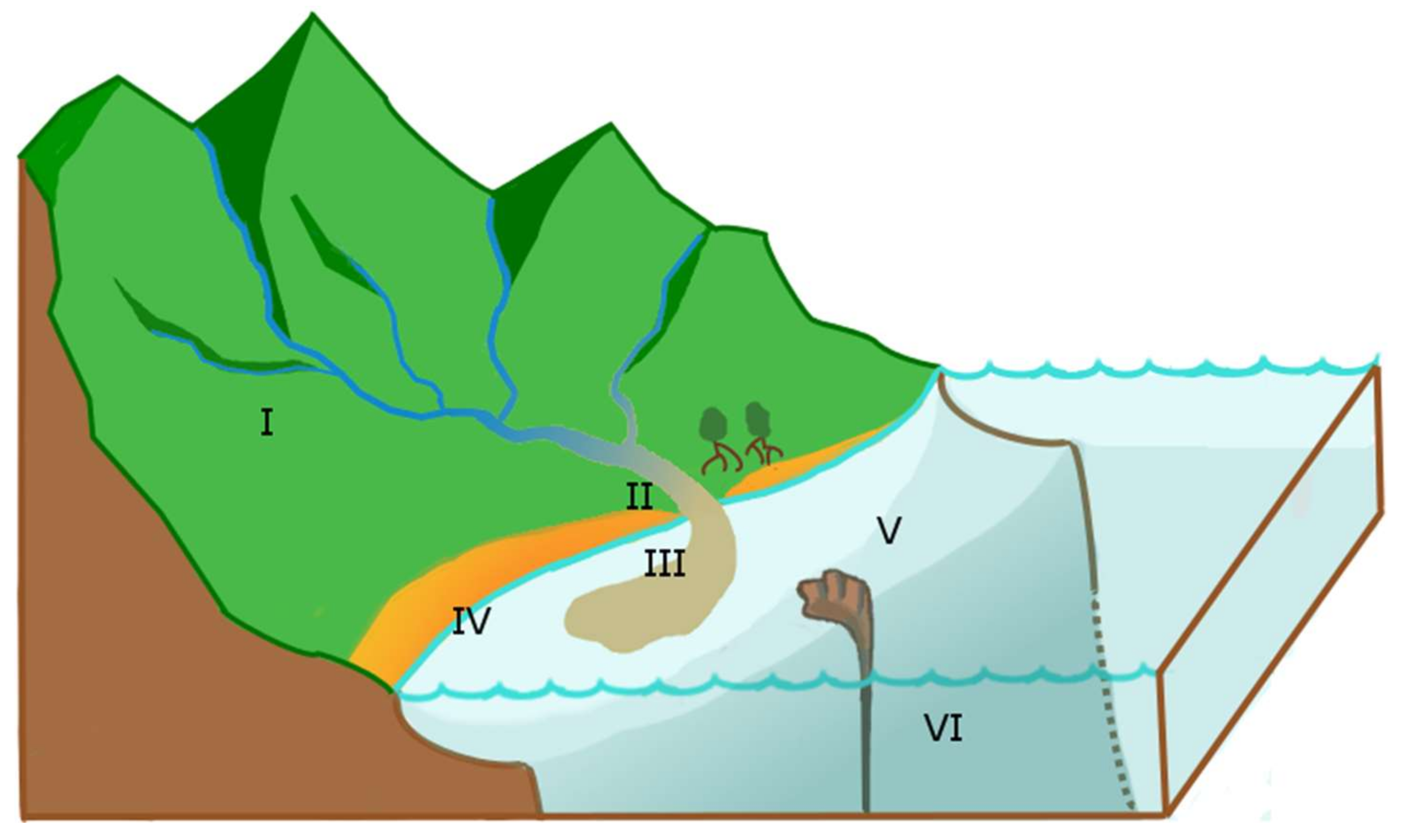
© 2018 by the author. Licensee MDPI, Basel, Switzerland. This article is an open access article distributed under the terms and conditions of the Creative Commons Attribution (CC BY) license (http://creativecommons.org/licenses/by/4.0/).
Share and Cite
MDPI and ACS Style
Ouillon, S. Why and How Do We Study Sediment Transport? Focus on Coastal Zones and Ongoing Methods. Water 2018, 10, 390. https://doi.org/10.3390/w10040390
AMA Style
Ouillon S. Why and How Do We Study Sediment Transport? Focus on Coastal Zones and Ongoing Methods. Water. 2018; 10(4):390. https://doi.org/10.3390/w10040390
Chicago/Turabian StyleOuillon, Sylvain. 2018. "Why and How Do We Study Sediment Transport? Focus on Coastal Zones and Ongoing Methods" Water 10, no. 4: 390. https://doi.org/10.3390/w10040390
Note that from the first issue of 2016, this journal uses article numbers instead of page numbers. See further details here.