Characterizing the Flash Flooding Risks from 2011 to 2016 over China
by
Meihong Ma
1,2, 
Bingshun He
1,3,*,
Jinhong Wan
1,*,
Pengfei Jia
4,
Xirong Guo
5,
Liang Gao
6,
Lane W. Maguire
6 and
Yang Hong
6,7 1
China Institute of Water Resources and Hydropower Research, Beijing 100038, China
2
School of Geographic and Environmental Sciences, Tianjin Normal University, Tianjin 300387, China
3
State Key Laboratory of Simulation and Regulation of Water Cycle in River Basin, Beijing 100038, China
4
CITIC Construction Co., Ltd., Beijing 100004, China
5
School of Management, Chengdu University of Information Technology, Chengdu 610225, China
6
Advanced Radar Research Center, and School of Civil Engineering and Environmental Science, University of Oklahoma, Norman, OK 73072, USA
7
Department of Hydraulic Engineering, Tsinghua University, Beijing 100084, China
*
Authors to whom correspondence should be addressed.
Water 2018, 10(6), 704; https://doi.org/10.3390/w10060704
Submission received: 23 March 2018
/
Revised: 11 May 2018
/
Accepted: 18 May 2018
/
Published: 30 May 2018
(This article belongs to the Special Issue Assessment of Current and Future Vulnerability of Flooding with Hydrologic/Hydraulic Modeling and Remote Sensing Techniques)
Abstract
:Flash floods induced by heavy rainfall occur frequently in China, which cause severe damages or even casualties every year. Flash floods generally occur in small catchments, and therefore were poorly documented. A Database including 963 flash flood events in China is compiled and studied in this study. Analytical results (a) indicate flash flood condition in China; (b) shed light on the spatial-temporal distribution of flash flood under heavy rainfall and (c) detect the characteristics of the 2016 flash flood. In 2016, the deaths due to flash floods were severe and concentrated, accounting for about half of the elderly and children. Hebei and Fujian provinces were most affected by flash floods. The disasters mainly occurred in July and the major types were river floods. Despite the frequent torrential rains, inadequate monitoring and early warning systems made the flash flooding condition even worse in 2016.
1. Introduction
A flash flood is the rapid flooding of geomorphic low-lying areas in response to intense rainfall associated with a severe thunderstorm or a sudden release of impounded water (e.g., dam or levee break) in a short period of time, generally within minutes up to 6 h in a catchment with areas of up to 400 km2 [1,2,3]. It has short lead times and is characterized by high velocity runoff and fast rising water. [4,5]. In global assessments of flood-related events, flash floods have the highest fatalities. According to the World Meteorological Organization (WMO), flash flooding is counted as the worst disaster in 105 out of 139 countries, causing millions of dollars loss every year [6]. In the United States from 1 October 2007 to 1 October 2015, 278 people were killed due to flash floods [7,8]. China also suffers great economic losses and casualties, with an average of 984 deaths per year [9]. Unfortunately, with increasing heavy precipitation events, flash flooding events are likely to be more frequent in the future [10,11,12]. Flash flooding events are also often associated with landslides and debris flows that may increase the threat to human life [13]. Therefore, in this study, flash flooding risks include not only river floods but also rainfall or flood related landslides and debris flows.
Previous studies have been conducted based on the historical flash flood events records. In Calabria, Aceto et al. [14] established a flash flood database and conducted trend analysis. Based on 21,549 flash flood events from 2006 to 2012 in the United States, Špitalar et al. [15] indicated that most flash flood events occur in rural settings and revealed an apparent trend in neither rural areas nor urban areas. Gourley et al. [16] proposed a survey-based data collection method and analyzed the impact and characteristics of summer floods in 2008. Gourley et al. [2] also established a georeferenced U.S. database of 98,668 flash flood events from 2006 to 2010, providing a long-term and detailed characterization of flash floods in terms of spatiotemporal behavior and specificity of impacts. In southern Europe, studies were mainly conducted on extreme storms and peak discharges for individual flash floods [17,18]. Gaume et al. [19] developed 550 extreme flood events in Europe, based mainly on peak discharge, with the rainfall duration <24 h and on watersheds generally <500 km2. Based on 247 deaths caused by 13 small-scale floods events, Jonkman and Kelman [13] proposed a classification according to the triggering factors and circumstances, which is a more valuable and consistent comparison of fatal flood events in different regions. In China, based on the unified flash flood observation, a database was compiled by the Ministry of Water Resources of the People’s Republic of China (MWR), a detailed analysis of 782-documented flash flood events from flash flood type, grade, spatial-temporal distribution and frequency concluded that the flash floods in China were mainly in July and concentrated in the southwest [20].
Although flash floods have become a hot topic throughout the world, there is still a lack of systematic and comprehensive study associated with their impacts and risks. Analysis of flash floods’ characteristics using precise long-sequence/large-coverage data is limited, and the data integration and construction technologies still need improvement [21].
Meanwhile, since the implementation of the China National Flash Flood Disaster Prevention and Control Project (CNFFPP), China has invested 160 million Yuan and achieved remarkable results, such as deaths caused by flash floods declining significantly [22]. However, in 2016, China still suffered severe flash floods, with a death toll recognized as the highest in the past three years and more than two times greater than in 2015. Therefore, based on 963 detailed and officially recorded flash floods, this study will, for the first time, analyze the characteristics, and discuss the reasons for the serious catastrophic events. The main purpose is to provide a window for scientists into understanding the severity of China’s flash floods.
2. Study Area and Data Resources
2.1. Study Area
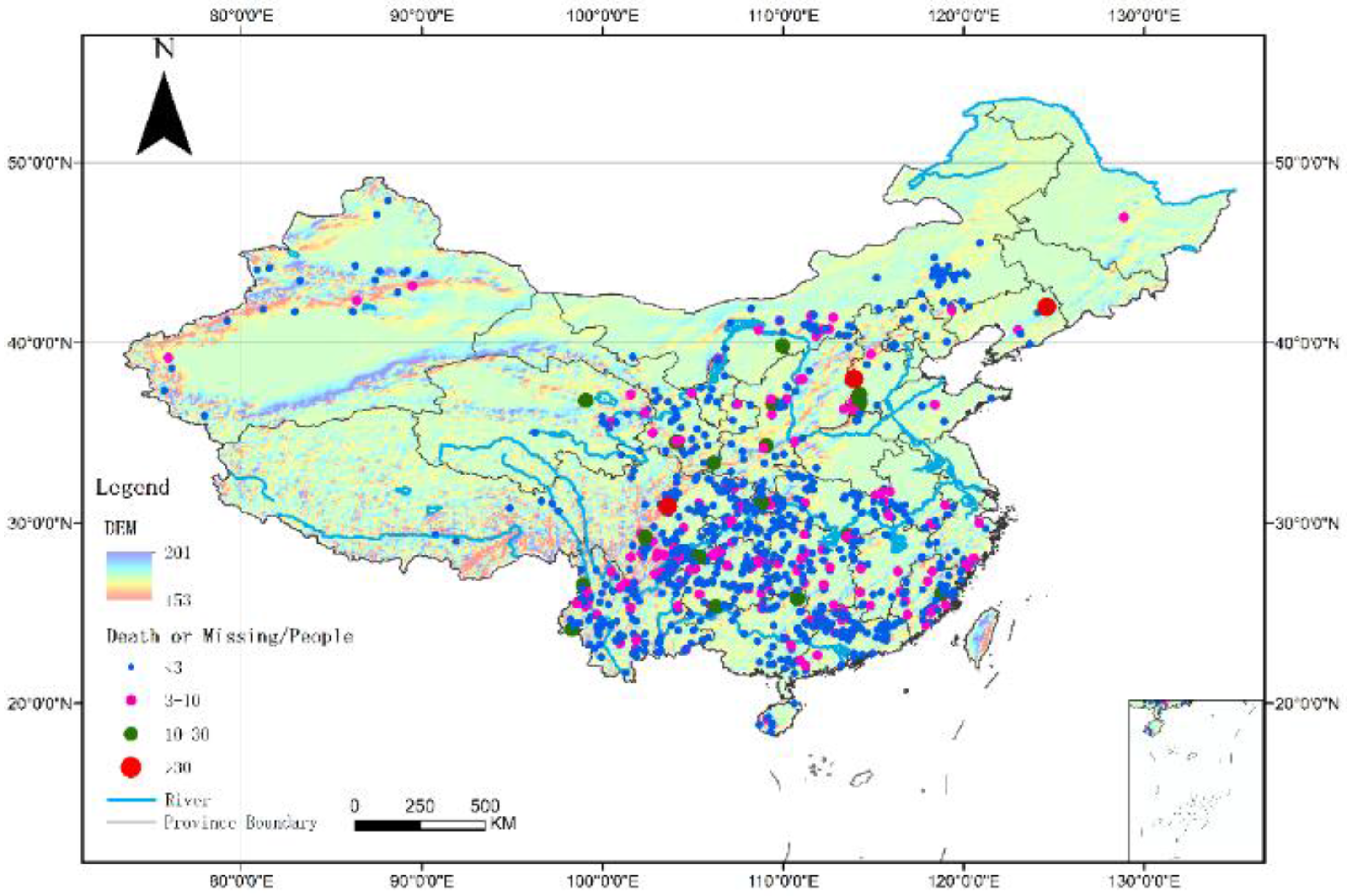
The study area covers Mainland China excluding Jiangsu and Shanghai. In China, mountainous areas account for about two thirds of the total area, of which flash flood prone areas account for about 48% [23]. Figure 1 shows the locations and fatalities of flash flood across China in 2011–2016, and disaster classification methods are based on the methods described in He et al. [20].
To minimize the economic loss and casualties, the Chinese government has carried out the CNFFPP since 2009, covering 2058 counties in 29 provinces, with a total area of 3.86 million km2 and a total population of 304 million. It mainly includes non-structural measures, supplemented by structural measures. Non-structural measures include monitoring and early-warning systems, investigation and evaluation, mass observation and mass preparedness, and emergency and safeguard systems. Structural measures include the governance of key flash flood ditches. Currently, China has carried out a series of implementations in flash flood prevention. The automatic monitoring stations in the key prevention areas achieved 50 km2 per station and a monitoring period of 10 min. The automatic station control area was 100 km2 per station. The basic characteristic parameters of 530,000 small catchments have identified, as well as the storm and flood patterns. There are 340 flash flood ditches that are governed. People’s awareness of disaster prevention has been improved [22], and all of the above provide convenient conditions for the analysis of flash floods in China.
2.2. Data Resources
The annual report entitled, “Bulletin of flood and drought disasters in China” provides the most current information available on flood disasters. It is compiled and published by the MWR and has well organized official flood hazards information. This study makes full use of these reported data from 2006 to 2016, as well as the Statistical Data of Flood Disaster documents from the MWR (2011–2016), and the official documents issued by other governmental departments. Meanwhile, the data are unified and normalized. If the same type of flash flood occurs in the same county, but in different towns, it is regarded as one flash flood event and the death toll is increased. If two types of flash floods occur simultaneously in the same place, we treat it as two separate incidents. If the same type of flash flood occurs at the same place but at different times (1–2 days apart), the first occurrence time was defined as the incident time, and the death toll was added. In an actual flood disaster defense, the weakest defensive ability is the elderly over 60 years old and the children under 18 years old. Therefore, the victims were categorized by age into minors (aged younger than 18 years), young adults and middle-aged adults (ages 18–60 years), and senior adults (aged older than 60 years). Victims were referred to as “locals” when the place of death coincides with the residence place; otherwise, the victims are denoted as a “non-natives”. In addition, grading standards follow the “Regulations on the prevention of geological disasters”, the details of which are listed in Table 1. All flash flood disaster events involved in this paper resulted in death or missing persons. Events that produced no casualties are not considered.
3. Characteristics of Flash Floods
3.1. High-Fatality Events
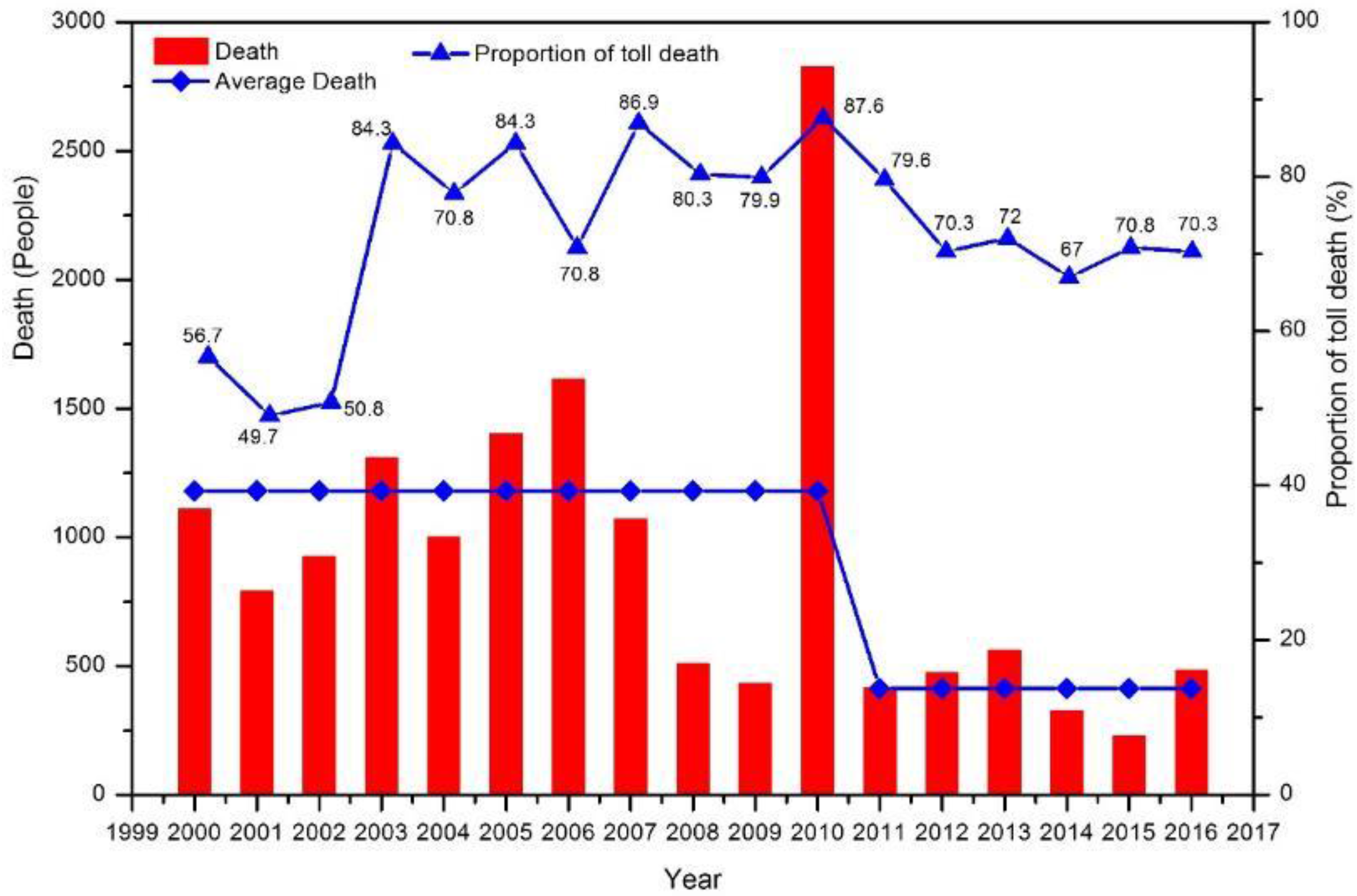
The high mortality is greatly caused by flash floods and related hazards in China. In 2016, there were 180 flash flood events, resulting in 481 deaths or missing, accounting for 70.3% of the total deaths caused by floods (684 deaths), and the ratio has remained the same since 2011. Figure 2 shows the number of deaths due to flash floods and their ratio to the total deaths caused by floods since 2000. The annual death toll caused by flash floods has dropped sharply, especially since 2011. With the gradual improvement of flash flood prevention measures, the average fatalities caused by flash floods has dropped by two thirds, but still a high proportion of the total deaths from floods. In 2010, there was a rapid increase in fatalities, mainly due to the extra-large flash flood in Zhouqu, Gansu, which resulted in the loss of 1765 people.
Compared with the same period in 2015, both the number of flash floods events and the number of missing or deaths increased in 2016 at rates of 53.8% and 121%, respectively, while the number of single-calamity toll increased by 42.1%. Table 2 shows the typical heavy rainfall and flash floods in some parts of China in 2016. Among them, the location information in Table 2 is the rough occurrence location information. It can be seen from Table 2 that the typical casualties caused by flash floods are also serious. On 9 July 2016, the maximum 3-h rainfall of 212 mm in Ta Zhuang Station, Minqing county, Fujian Province, reached over 60% of the historical maximum, resulting in 39 deaths. On 16 August 2016 in Xichuan River of Shanxi Province, the 20-min rainfall was 55 millimeters with a peak of 75 cubic meters per second, resulting in seven deaths and one missing person.
3.2. Time Distribution of Disaster Severity
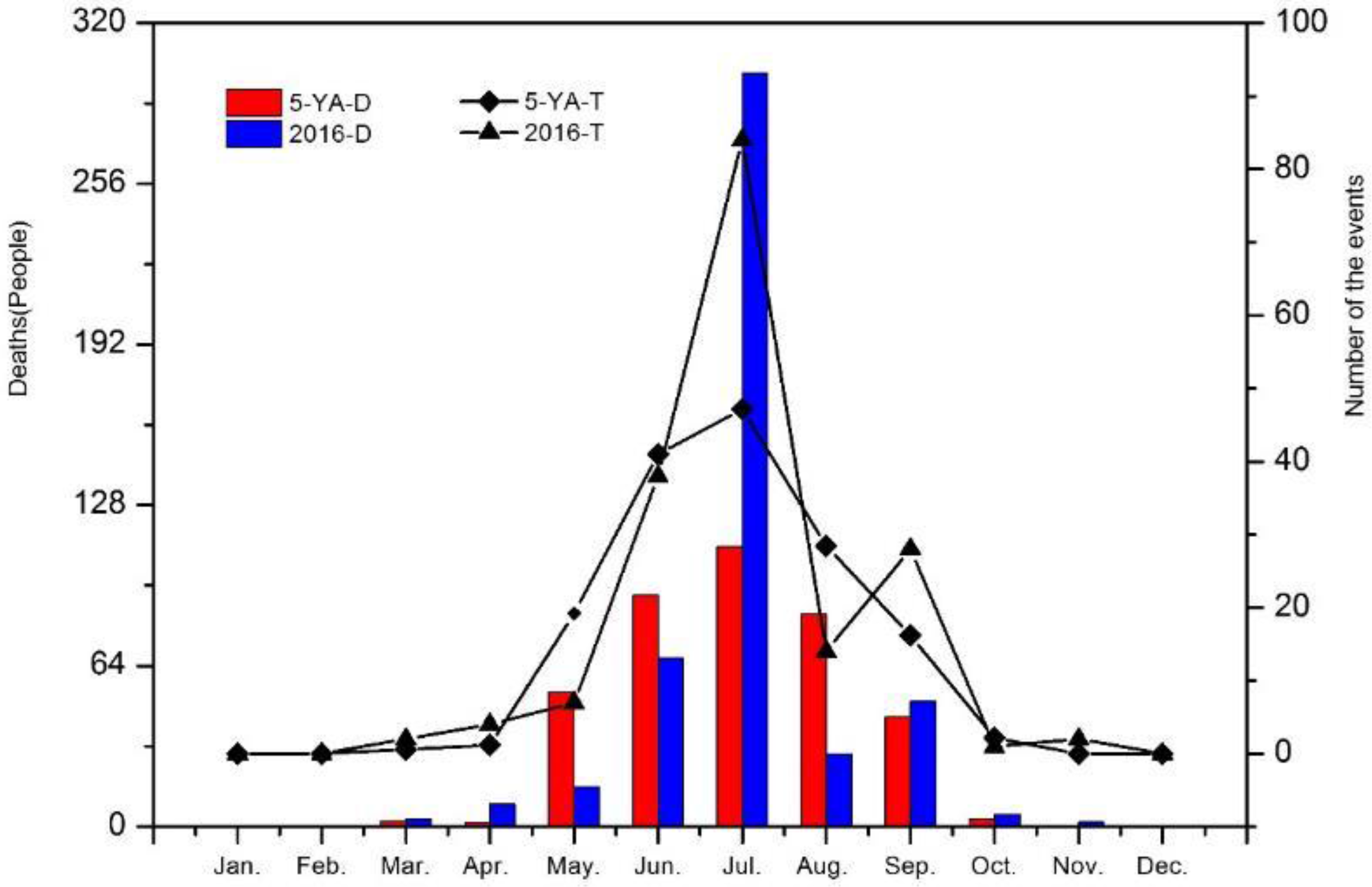
Figure 3 shows the monthly distribution of flash flooding. In all of the following graphs, times means the number of the events. In 2016, there are 180 flash flood events occurred from March to November. However, in recent years, there were no flash floods in November and only one flash flood event in March 2012. Therefore, the time span was longer than in previous years. The flash floods were mainly concentrated in June, July, August and September, especially in July, both the number of flash floods (46.7%) and the fatalities (62.4%) were the largest in 2016, the average number of deaths per flash flood event was as high as 3.6, 1.7 times more than in other months. July 2016 was also the most serious month for a 6-year period, which is 5.9 times for the six-year average. The severity of flash floods is ranked as follows: July > June > September > August. In addition, the fatalities in May, August and June 2016 decreased by 70.4%, 65.9% and 27.2%, respectively. According to the seasonal distribution in China, the flash flood events started to increase in the late spring, with an obvious increase in the wet season of summer and a marked decrease in autumn.
3.3. Spatial Distribution of Disaster Severity
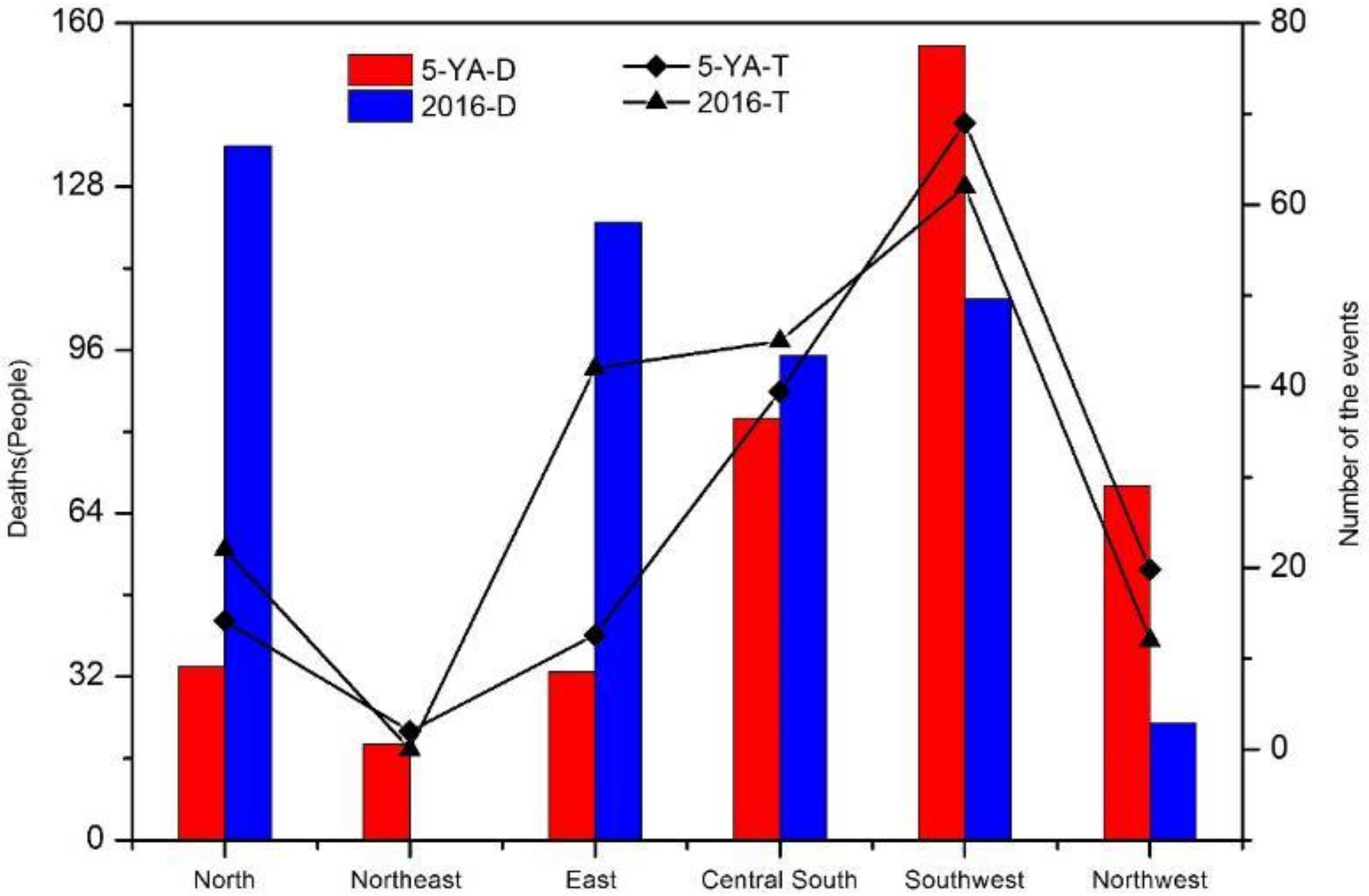
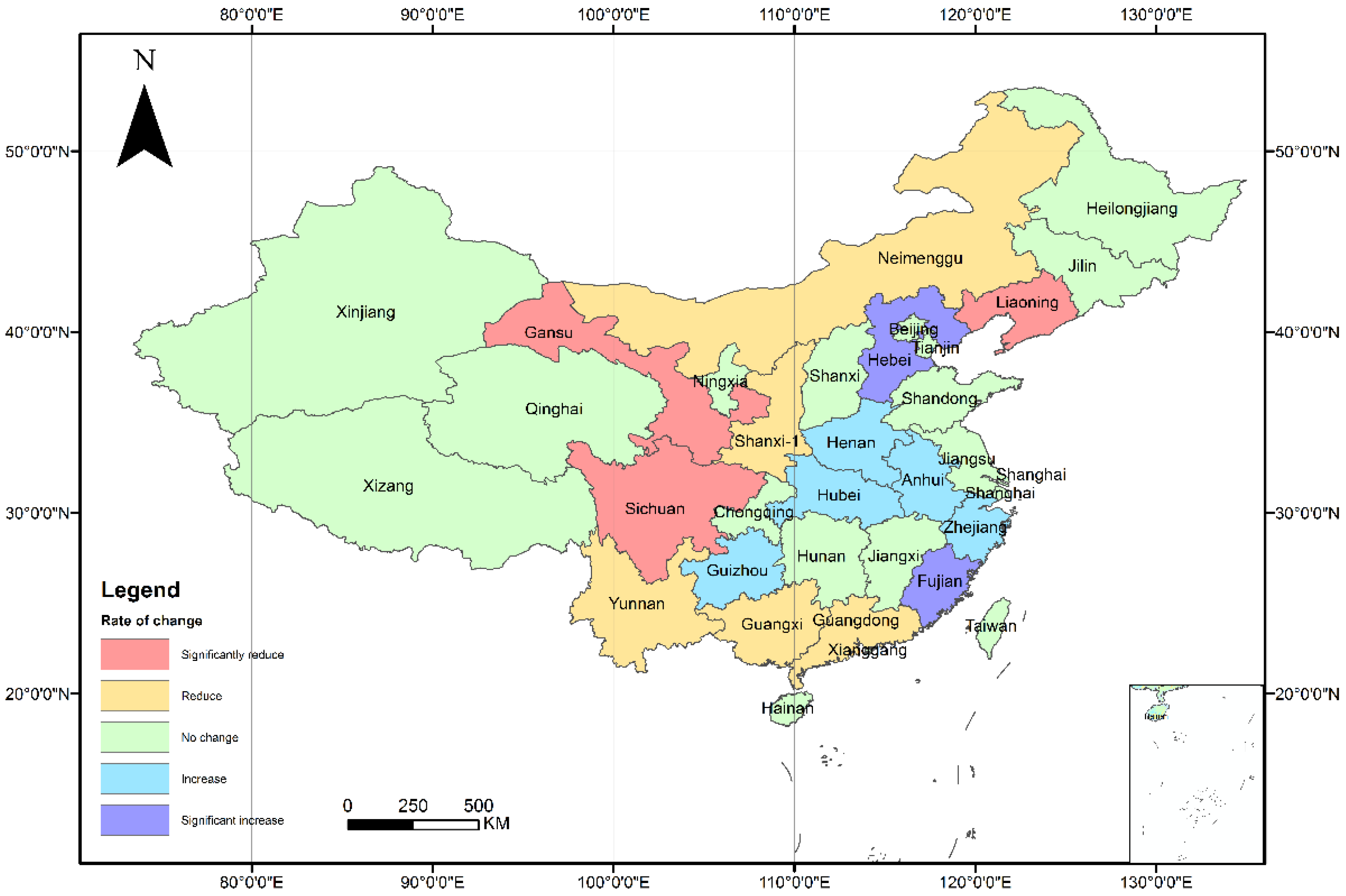
In terms of the regional distribution, the north region experienced the worst flash flooding, and accounted for 28.3% of the total deaths, no flash floods occurred in the northeast China. Southwest China suffers the most frequent flash flood catastrophes due to the topography and monsoon climate, causing 42.3% of total fatalities in 2011–2015. In 2014, the percentage of deaths from flash floods in Southwest China was as high as 63.7% of the total deaths, indicating that the impact of flash floods in this region was very serious. Figure 4 shows the regional distribution in 2011–2016. 5-YA-D, 5-YA-T represent the average death, the average times from 2011 to 2015; 2016-T, 2016-D represent the average death, the average times in 2016. Compared with the 5-YA-D, 2016-D exceeded 300% in the north and 266.7% in east, which was anomalous compared with the previous years. However, in Southwest China, it dropped by 31.9%, while in Northwest China, it decreased by 66.9%. In the meantime, flash floods occur less frequently in the Northeast. Therefore, in 2016, the most severe flash floods occurred in the northeast China and the anomalies in the southwest region.
Figure 5 shows the changes in mortality rate by province in 2016, and 21 provinces suffered from flash floods; and the total deaths from flash floods in 13 provinces accounted for more than 60% of the total deaths associated with floods. Floods in Shanxi, Ningxia, Qinghai are all flash floods. The most seriously injured province is Hebei—while, in previous years, the most casualties occurred in southwest such as Yunnan Province (2014 or 2015) and Sichuan Province (2012 or 2013). In 2016, the three provinces most affected by the flash floods were Hebei, Fujian and Guizhou, with a mortality rate of 50.9%. Compared with the 5 -YA, Hebei and Fujian showed obvious changes, which were 20 times and eight times, respectively, over the 5-YA.
3.4. Breakdown of Deaths by Disaster Types and Levels
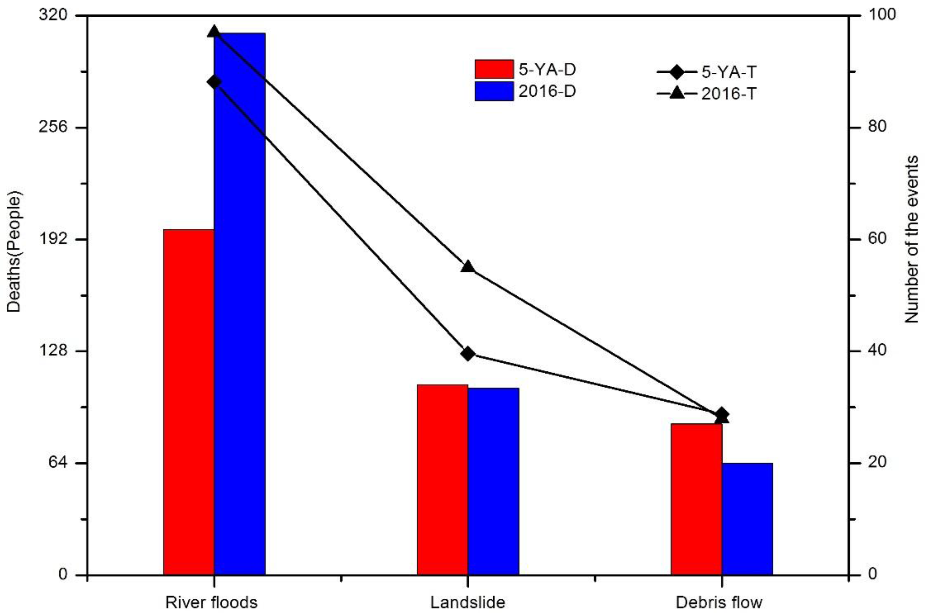
Compared with 5-YA, river floods occur most frequently and have the deadliest consequences, and the number exceeds the sum of that of debris flows and landslides, accounting for 53.9% of the total times and 64.4% of the total death in 2016 (Figure 6). The landslides remained unchanged, while debris flow decreased significantly. In addition, the deaths in 2016 were only lower than in 2012, with the second highest fatalities.
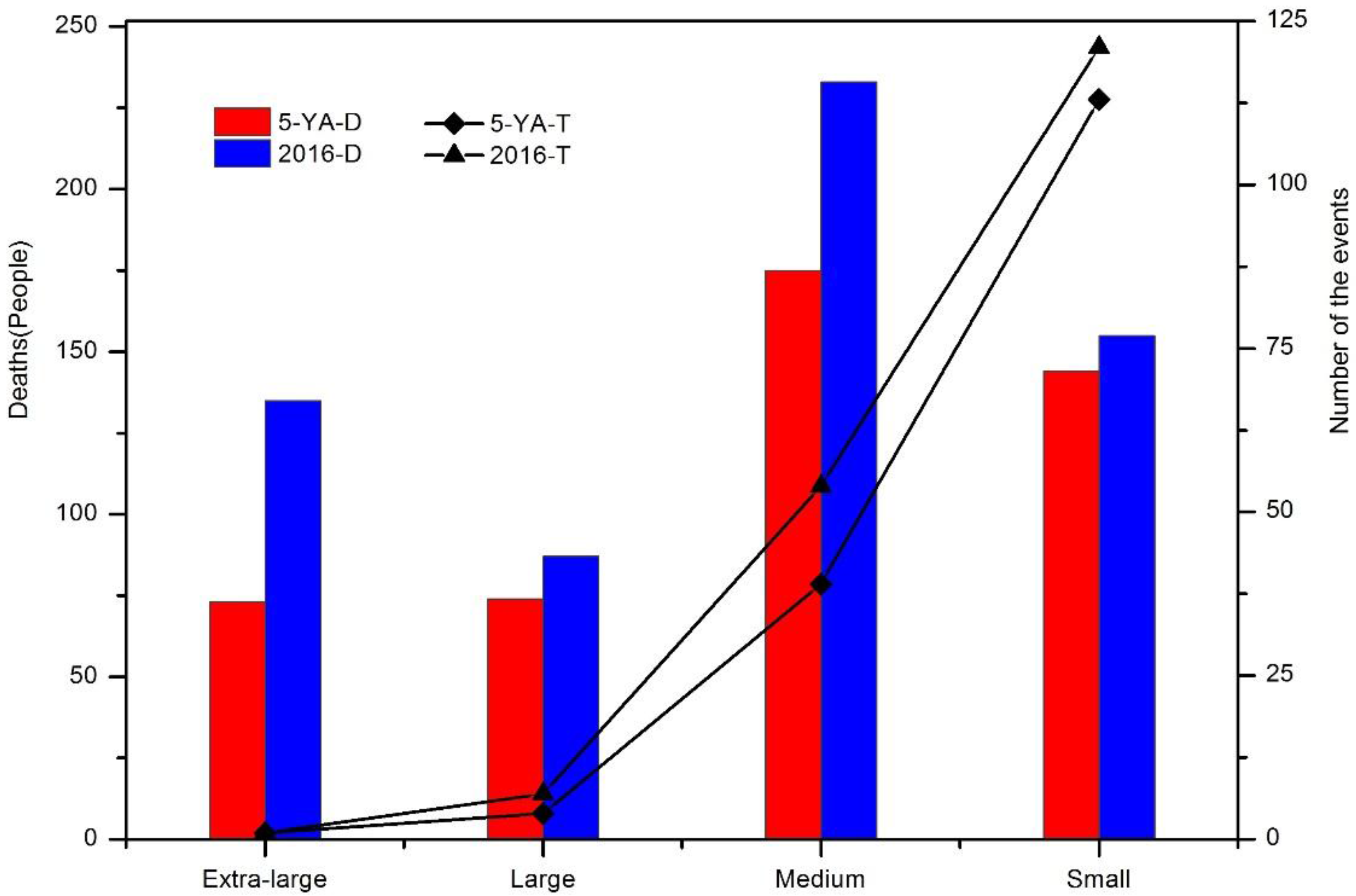
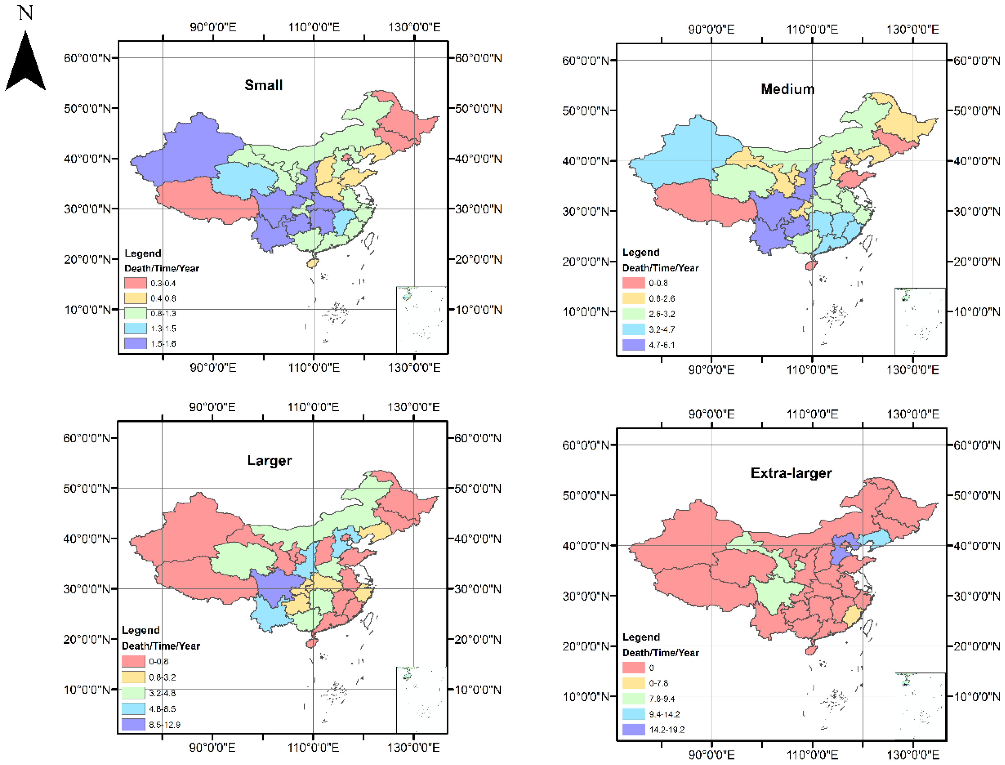
Although small and medium-sized flash floods occur frequently, large-scale flash floods cause great losses. For instance, two large-scale floods occurred in Jingtai County of Hebei Province and Minqing County of Fujian Province, accounting for 22% of the total deaths, with an average of 67.5 deaths each. In 2016, the number of small and medium-sized flash flood events accounted for 96.1% of the all events, and 63.6% of the total number of deaths or missing people caused by flash floods. Compared with the five-year average, both the flash flood events and fatalities have increased (Figure 7). In 2016, the deaths from extra-large flash floods raised mostly, as well as the medium-sized flash floods. According to the statistical analysis of the annual mean deaths, small and medium-sized flash floods are mainly concentrated in the southwestern regions such as Yunnan, Sichuan, Guizhou and Shaanxi provinces. The flash floods in Xinjiang are rather special for the low number of both flash flood occurrences and casualties. Large flash flood events are mainly concentrated in Sichuan, followed by Yunnan, Shanxi and Hebei. From 2011 to 2016, Hebei, Liaoning, Sichuan, Gansu and Fujian provinces have experienced extra-large flash floods (Figure 8). Especially in areas such as Hebei and Liaoning that are not prone to flash floods, people’s awareness of defense is weak, once a flash flood occurs; it generally brings greater economic losses and casualties. Therefore, it is also necessary to strengthen defensive research in areas where flash floods are infrequent.
3.5. Composition of Affected Populations
In 2016, there were 481 deaths, of which about half were elderly people and minors. When the flash floods struck, on one hand, the elderly did not give up their family’s property and they were reluctant to withdraw in time; on the other, the elderly were inconvenient to move; while the children did not have a defensive awareness, they all belonged to vulnerable groups. Meanwhile, the local people accounted for 90% and non-natives of 10%, respectively. The non-natives are mainly migrant workers, traveling, visiting relatives, etc. In addition, according to the survey by MWR, the floating population has also become a vulnerable group threatened by mountain torrents. For example, in 2013, a flash flood occurred in the Dongsheng District of Inner Mongolia, killing 11 workers. In 2015, a flash flood disaster occurred in Chang’an District of Shanxi Province, killing nine tourists.
4. Discussions
4.1. Heavy Rainfall
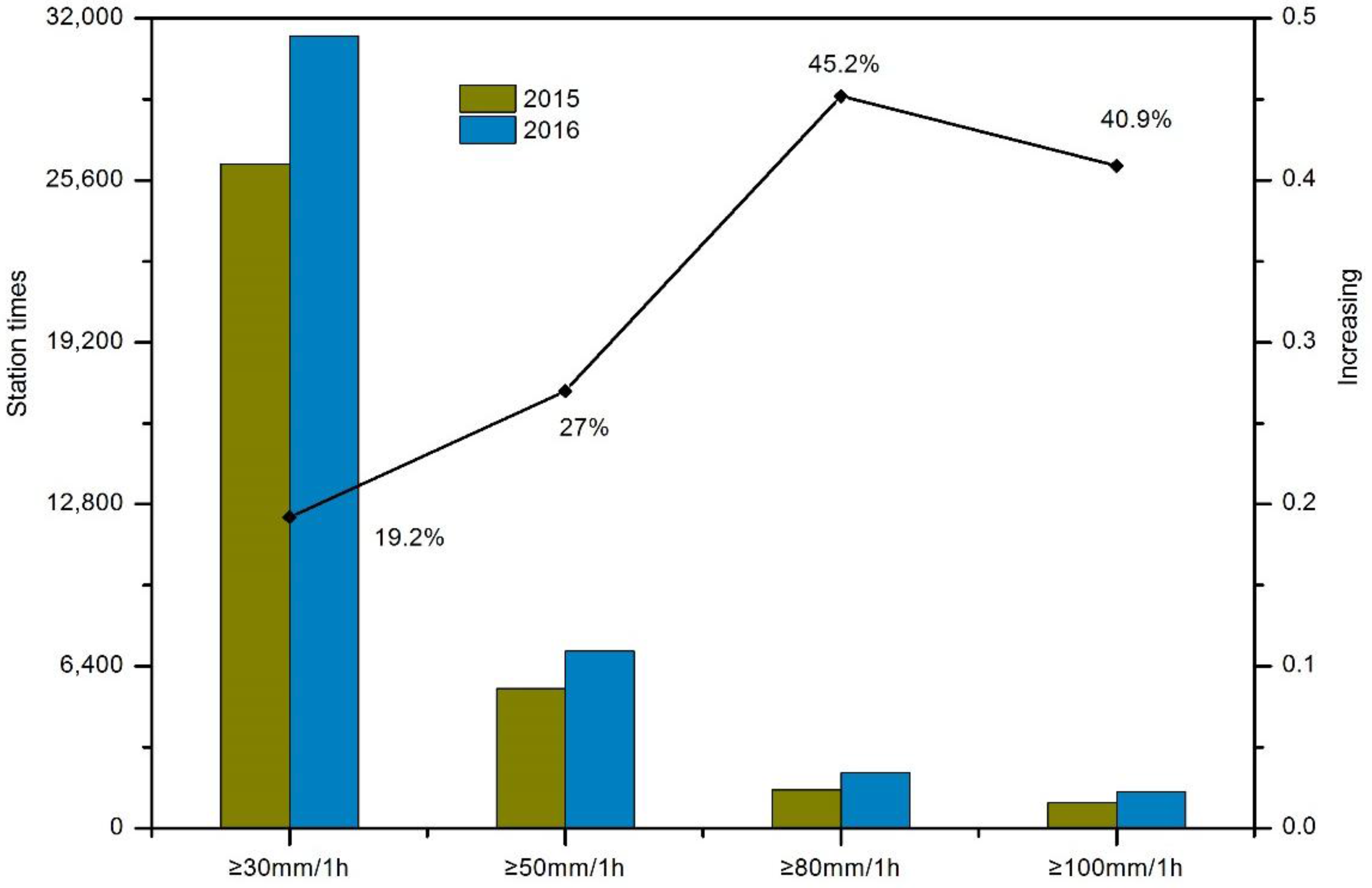
In 2016, there were 51 heavy precipitation events in China, with an average precipitation of 719 mm, 1.5% more than that in normal years. Three factors that rain, rain intensity and the coverage of rain areas were the greatest since 1998. According to 34,030 rainfall station statistics, the rainfall intensity in 2016 increased significantly, of which the number of stations with rainfall over 30 mm per hour increased by 19.2%, and the rainfall over 80 mm per hour increased by 45.2% (Figure 9). In Table 2, the rainfall of Xinyi City and Minqing County exceeded the historical extremes, up to 60%. A total of 473 rivers across the country were above the warning level, the highest in 20 years [24]. In addition, defense concentrated in the severe flash flood areas; it is easy to ignore the less frequent flash flood areas. Moreover, when flash floods occur, people can easily relax their vigilance. Once flash floods occur again, they will easily lead to huge losses, such as Fujian, Guangdong, Hainan and other provinces have repeatedly suffered from flash floods.
4.2. Imperfect Monitoring and Early Warning Systems
In China, 2058 county-level monitoring and early warning platforms were established. When a flash flood occurs, it plays a key role in monitoring, issuing warnings. However, in 2016, for one thing, this system is extremely vulnerable to paralysis under extreme conditions; for another, determining the accurate early warning indicators and thresholds is still a technical difficulty, especially in remote, complex topography, economically underdeveloped areas. At the same time, weak defense ability and awareness, and the incomplete way of early warning communication can also worsen the condition.
In addition, flash flood disasters sometimes occur outside of the prevention planning areas, and areas with economies based on migrant work, farming, and tourism are strongly affected.
5. Conclusions
Flash floods remain a poorly understood and documented natural disaster, causing huge economic losses and severe casualties. According to a survey of 25 major flash flood events in Europe during the past two decades [4], half were properly documented on routine stage measurements. At present, the main method of flash flood defense is early warning and forecasting. Generally, statistical analysis of flow and rainfall data in the research area is conducted to study the law of the flash flood occurrence, and then to determine its critical rainfall, or to study the mechanism of flash flood formation and determine its early warning flow [25,26]. Nowadays, the critical rainfall and hydrological model are the commonly used methods for flash flood prevention at home and abroad. However, a large amount of historical data is required for statistical analysis or for the determination of hydrological model parameters. Methods for obtaining flash flood disaster data include statistical analysis, Gis-based parameter extraction, data mining, remote sensing satellites, etc. [27,28], but these data obtained are usually uncertain. In this article, the data comes mainly from MWR. It is an effective integration of data from various sources, and it is authoritative, systematic, and comprehensive.
Based on the 6-year flash flood database (2011–2016) documented in detail by the MWR, the characteristics of China’s 2016 flash floods were explored in terms of spatial-temporal distribution, types, levels, and composition. The main conclusions of this paper are listed below: (1) the death toll was relatively high in 2016 but lower than 2013. The proportion of total deaths from flash floods to the death from floods has remained nearly the same since 2010, and flash floods are still the main cause of deaths in flood disasters; (2) flash flood usually occurred from March to November, and the time span extended from 2011 to 2016. The magnitude of the flash flood monthly severity is July > May > April > August. North China is the worst-hit district, and Hebei Province the worst-hit Province. The deaths caused by flash floods in Hebei, Fujian and Guizhou provinces accounted for 50.9% of the total deaths in China; (3) in terms of the scales, medium-scale flash floods are the most common and widespread, while extra-large scale flash floods cause fatalities. The disaster magnitude levels are as follows: the medium > the small > extra-large scale = large scale. River floods occur most frequently, and account for half of all types of flash floods; (4) among the deaths in different age groups, the young adults and middle-aged adults have become vulnerable groups threatened by flash floods. Non-native residents, such as migrant workers, farming, tourism personnel and other issues, are affected by flash floods. The main reason is that: when flash floods come, the elderly are inconvenient to move and the children are not aware of the dangers. The non-native residents are not familiar with the local defense knowledge and do not know the transfer route, etc.
This paper aims to analyze the spatial-temporal characteristics of flash flood events in China. Flash floods are associated with high-intensity rainfalls in short periods. In the future, cross-analysis methods will be introduced to study flash floods’ characteristics, as well as the causes of death and spatial patterns of mortality. Information on social factors (income, poverty, and ethnicity) will be added in the analysis to gain more insight into the effects of social vulnerability factors, all of which will contribute to better understanding flash floods’ characteristics in different affected areas, and then adopting the targeted measures for defense.
Author Contributions
M.M. and B.H. was responsible for data analysis, writing the manuscript and communicating with the journal. The other people were in charge of supervising the structure of the paper and providing the main points for discussion in the Results and Introduction.
Acknowledgments
This work was supported by National Natural Science Foundation of China (NSFC. General Projects: (Grant No. 41471430), and the China National Flash Flood Disaster Prevention and Control Project (126301001000150068), and other projects (JZ0145B2017, Z161100001116102, HNSW-SHZH-2015-06). The authors wish to thank the anonymous reviewers for their comments and suggestions.
Conflicts of Interest
The authors declare no conflict of interest.
References
- Hong, Y.; Gourley, J.J. Flash Flood. In Peter Bobrowsky, Encyclopedia of Natural Hazards; Springer: Dordrecht, The Netherlands, 2013; pp. 324–325. ISBN 978-90-481-8699-0. [Google Scholar]
- Gourley, J.J.; Hong, Y.; Flamig, Z.L.; Arthur, A.; Clark, R.; Calianno, M.; Ruin, I.; Ortel, T.; Wieczorek, M.E.; Kirstetter, P.-E.; et al. A unified flash flood database across the United States. Bull. Am. Meteorol. Soc. 2013, 94, 799–805. [Google Scholar] [CrossRef]
- Georgakakos, K.P.; Hudlow, M.D. Quantitative precipitation forecast techniques for use in hydrologic forecasting. Bull. Am. Meteorol. Soc. 1984, 65, 1186–1200. [Google Scholar] [CrossRef]
- Marchi, L.; Borga, M.; Preciso, E.; Gaume, E. Characterisation of selected extreme flash floods in Europe and implications for flood risk management. J. Hydrol. 2010, 394, 118–133. [Google Scholar] [CrossRef]
- Kellar, D.M.M.; Schmidlin, T.W. Vehicle-related flood deaths in the United States, 1995–2005. J. Flood Risk Manag. 2012, 5, 153–163. [Google Scholar] [CrossRef]
- World Meteorological Organization. Guide to Meteorological Instruments and Methods of Observations, 6th ed.; WMO: Geneva, Switzerland, 1996; Chapter 6, No. 8. [Google Scholar]
- Gourley, J.J.; Flamig, Z.L.; Vergara, H.; Kirstetter, P.E.; Clark, R.A.; Argyle, E.; Arthur, A.; Martinaitis, S.; Terti, G.; Erlingis, J.M.; et al. The flooded locations and simulated hydrographs (flash) project: Improving the tools for flash flood monitoring and prediction across the United States. Bull. Am. Meteorol. Soc. 2017, 98, 361–372. [Google Scholar] [CrossRef]
- Saharia, M.; Kirstetter, P.E.; Gourley, J.J.; Hong, Y.; Vergara, H.; Flamig, Z.L. Accounting for Rainfall Spatial Variability in the Prediction of Flash Floods; American Geophysical Union: Washington, DC, USA, 2016. [Google Scholar]
- State Flood Control and Drought Relief Office (SFCDRO), the Ministry of Water Resources of the People’s Republic of China. Bulletin of Flood and Drought Disasters in China; China Water Power Press: Beijing, China, 2014. (In Chinese)
- Scoccimarro, E.; Gualdi, S.; Bellucci, A.; Zampieri, M.; Navarra, A. Heavy precipitation events over the euro-mediterranean region in a warmer climate: Results from cmip5 models. Reg. Environ. Chang. 2016, 16, 595–602. [Google Scholar] [CrossRef]
- Pendergrass, A.G.; Hartmann, D.L. Changes in the distribution of rain frequency and intensity in response to global warming*. J. Clim. 2014, 27, 8372–8383. [Google Scholar] [CrossRef]
- Huang, P.N.; Li, Z.J.; Li, Q.L.; Zhang, K.; Zhang, H.C. Application and comparison of coaxial correlation diagram and hydrological model for reconstructing flood series under human disturbance. J. Mt. Sci. 2016, 13, 1245–1264. [Google Scholar] [CrossRef]
- Jonkman, S.N.; Kelman, I. An analysis of the causes and circumstances of flood disaster deaths. Disasters 2005, 29, 75–97. [Google Scholar] [CrossRef] [PubMed]
- Aceto, L.; Caloiero, T.; Pasqua, A.A.; Petrucci, O. Analysis of damaging hydrogeological events in a mediterranean region (calabria). J. Hydrol. 2016, 541, 510–522. [Google Scholar] [CrossRef]
- Špitalar, M.; Gourley, J.J.; Lutoff, C.; Kirstetter, P.E.; Brilly, M.; Carr, N. Analysis of flash flood parameters and human impacts in the US from 2006 to 2012. J. Hydrol. 2014, 519, 863–870. [Google Scholar] [CrossRef]
- Gourley, J.J.; Giangrande, S.E.; Hong, Y.; Flamig, Z.L.; Schuur, T.; Vrugt, J.A. Impacts of polarimetric radar observations on hydrologic simulation. J. Hydrometeorol. 2010, 11, 781–796. [Google Scholar] [CrossRef]
- Rong, H.U.; Ke, L.I. Analysis of abnormal injected pressure changes in polymer flooding reservoir and its countermeasures. J. Jianghan Pet. Inst. 2003, 25, 75–76. [Google Scholar]
- Gaume, E.; Bain, V.; Bernardara, P.; Newinger, O.; Barbuc, M.; Bateman, A.; Blaškovičová, L.; Blöschl, G.; Borga, M.; Dumitrescu, A.; et al. A compilation of data on European flash floods. J. Hydrol. 2009, 367, 70–78. [Google Scholar] [CrossRef]
- Ma, Z.Q.; Shi, Z.; Zhou, Y.; Xu, J.F.; Yu, W.; Yang, Y.Y. A spatial data mining algorithm for downscaling TMPA 3B43 V7 data over the Qinghai–Tibet Plateau with the effects of systematic anomalies removed. Remote Sens. Environ. 2017, 200, 378–395. [Google Scholar] [CrossRef]
- He, B.; Huang, X.; Ma, M.; Chang, Q.; Tu, Y.; Li, Q.; Zhang, K.; Hong, Y. Analysis of flash flood disaster characteristics in china from 2011 to 2015. Nat. Hazards 2018, 90, 407–420. [Google Scholar] [CrossRef]
- Bao, H.; Zhang, K.; Wang, L.; Li, Z.; Yao, C. Application of a developed distributed hydrological model based on the mixed runoff generation model and 2-D kinematic wave flow routing model for better flood forecasting. Atmos. Sci. Lett. 2017, 18, 284–293. [Google Scholar] [CrossRef]
- Guo, L.; He, B.; Ma, M.; Chang, Q.; Li, Q.; Zhang, K.; Hong, Y. A comprehensive flash flood defense system in China: Overview, achievements, and outlook. Nat. Hazards 2018, 92, 727–740. [Google Scholar] [CrossRef]
- Ma, M.; Wang, H.; Jia, P.; Liu, R.; Hong, Z.; Labriola, L.G.; Homg, Y.; Miao, L. Investigation of inducements and defenses of flash floods and urban waterlogging in Fuzhou, China, from 1950 to 2010. Nat. Hazards 2018, 91, 1–16. [Google Scholar] [CrossRef]
- Liu, K.; Li, Z.; Yao, C.; Chen, J.; Zhang, K.; Saifullah, M. Coupling the k-nearest neighbor procedure with the Kalman filter for real-time updating of the hydraulic model in flood forecasting. Int. J. Sediment Res. 2016, 31, 149–158. [Google Scholar] [CrossRef]
- Hu, Y. Question and answer on key techniques of field investigation for impact assessment of flash flood disasters. China Flood Drought Manag. 2016, 26, 23–28. [Google Scholar]
- Guo, K.; Liang, G.; He, B. Dynamic critical precipitation flash flood warning method and its application based on API Hydrologic Model. Int. J. Hydroelectr. Energy 2016, 34, 74–77. [Google Scholar]
- Hapuarachchi, H.A.P.; Wang, Q.J.; Pagano, T.C. A review of advances in flash flood forecasting. Hydrol. Processes 2011, 25, 2771–2784. [Google Scholar] [CrossRef]
- Youssef, A.M.; Pradhan, B.; Hassan, A.M. Flash flood risk estimation along the St. Katherine road, southern Sinai, Egypt using GIS based morphometry and satellite imagery. Environ. Earth Sci. 2011, 62, 611–623. [Google Scholar] [CrossRef]
Figure 1.
Locations and fatalities of flash floods across China in 2011–2016.

Figure 2.
Number of deaths due to flash floods and their ratio to the total deaths caused by floods.
Figure 2.
Number of deaths due to flash floods and their ratio to the total deaths caused by floods.

Figure 3.
Monthly distribution of averaged deaths in 2011–2016. (5-YA-D: the number of deaths from 2011 to 2015, 5-YA-T: the number of flash flood events from 2011 to 2015; 2016-D: the number of deaths in 2016, 2016-T: the number of flash flood events in 2016).
Figure 3.
Monthly distribution of averaged deaths in 2011–2016. (5-YA-D: the number of deaths from 2011 to 2015, 5-YA-T: the number of flash flood events from 2011 to 2015; 2016-D: the number of deaths in 2016, 2016-T: the number of flash flood events in 2016).

Figure 4.
Regional distribution of flash floods in 2011–2016. (5-YA-D: the number of deaths from 2011 to 2015, 5-YA-T: the number of flash flood events from 2011 to 2015; 2016-D: the number of deaths in 2016, 2016-T: the number of flood events in 2016).
Figure 4.
Regional distribution of flash floods in 2011–2016. (5-YA-D: the number of deaths from 2011 to 2015, 5-YA-T: the number of flash flood events from 2011 to 2015; 2016-D: the number of deaths in 2016, 2016-T: the number of flood events in 2016).

Figure 5.
Changing rate of death toll of each province in 2016 compared with the 5-YA.

Figure 6.
Fatality of different types of natural disasters in 2011–2016. (5-YA-D: the number of deaths from 2011 to 2015, 5-YA-T: the number of flash flood events from 2011 to 2015; 2016-D: the number of deaths in 2016, 2016-T: the average number of flash flood events in 2016).
Figure 6.
Fatality of different types of natural disasters in 2011–2016. (5-YA-D: the number of deaths from 2011 to 2015, 5-YA-T: the number of flash flood events from 2011 to 2015; 2016-D: the number of deaths in 2016, 2016-T: the average number of flash flood events in 2016).

Figure 7.
Grade distribution of flash floods in 2011–2016. (5-YA-D: the average number of deaths from 2011 to 2015, 5-YA-T: the average number of flash flood events from 2011 to 2015; 2016-D: the number of deaths in 2016, 2016-T: the average number of flash flood events in 2016).
Figure 7.
Grade distribution of flash floods in 2011–2016. (5-YA-D: the average number of deaths from 2011 to 2015, 5-YA-T: the average number of flash flood events from 2011 to 2015; 2016-D: the number of deaths in 2016, 2016-T: the average number of flash flood events in 2016).

Figure 8.
Intensity distributions of flash flood in different levels in 2016. Death/Time/Year: the average number of deaths each year due to flash floods.
Figure 8.
Intensity distributions of flash flood in different levels in 2016. Death/Time/Year: the average number of deaths each year due to flash floods.

Figure 9.
Comparison of rain between 2015 and 2016 (34,030 base stations).


Table 1.
Divisional criteria of flash floods.
| Death or Missing/People | Scale |
|---|---|
| 0–3 | small |
| 3–10 | medium |
| 10–30 | large |
| 30– | extra-large |
Table 2.
Typical events of heavy rainfall and flash floods in 2016.
| Time | Location (County, Province) | Type | Precipitation (mm) | Maximum Rain Intensity (mm/h) | Death (Person) | Missing (Person) |
|---|---|---|---|---|---|---|
| 20 May 2016 | Xinyi county, Guangdong | Debris flow | 466 | 430/6 h, 144/1 h | 4 | 0 |
| 19 June 2016 | Qichun county, Hubei | Flash flood | 278 | 116.5/1 h, 199/6 h | 7 | 5 |
| 9 July 2016 | Minqing county, Fujian | Flash flood | 297 | 82.5/1 h, 212/3 h | 39 | 0 |
| 9 July 2016 | Yongtai county, Fujian | Debris flow | 301.5 | 115/1 h, 282/3 h | 9 | 2 |
| 19 July 2016 20 July 2016 | Ci county, Hebei | Debris flow | 644.5 | - | 16 | 2 |
| 16 August 2016 | Anzhai county, Shanxi | Flash flood | - | 55/20 min | 7 | 1 |
© 2018 by the authors. Licensee MDPI, Basel, Switzerland. This article is an open access article distributed under the terms and conditions of the Creative Commons Attribution (CC BY) license (http://creativecommons.org/licenses/by/4.0/).
Share and Cite
MDPI and ACS Style
Ma, M.; He, B.; Wan, J.; Jia, P.; Guo, X.; Gao, L.; Maguire, L.W.; Hong, Y. Characterizing the Flash Flooding Risks from 2011 to 2016 over China. Water 2018, 10, 704. https://doi.org/10.3390/w10060704
AMA Style
Ma M, He B, Wan J, Jia P, Guo X, Gao L, Maguire LW, Hong Y. Characterizing the Flash Flooding Risks from 2011 to 2016 over China. Water. 2018; 10(6):704. https://doi.org/10.3390/w10060704
Chicago/Turabian StyleMa, Meihong, Bingshun He, Jinhong Wan, Pengfei Jia, Xirong Guo, Liang Gao, Lane W. Maguire, and Yang Hong. 2018. "Characterizing the Flash Flooding Risks from 2011 to 2016 over China" Water 10, no. 6: 704. https://doi.org/10.3390/w10060704
Note that from the first issue of 2016, this journal uses article numbers instead of page numbers. See further details here.