The Role of Geohydrology in the Determination of a Spatial Development Framework in the Vredefort Dome World Heritage Site

Abstract
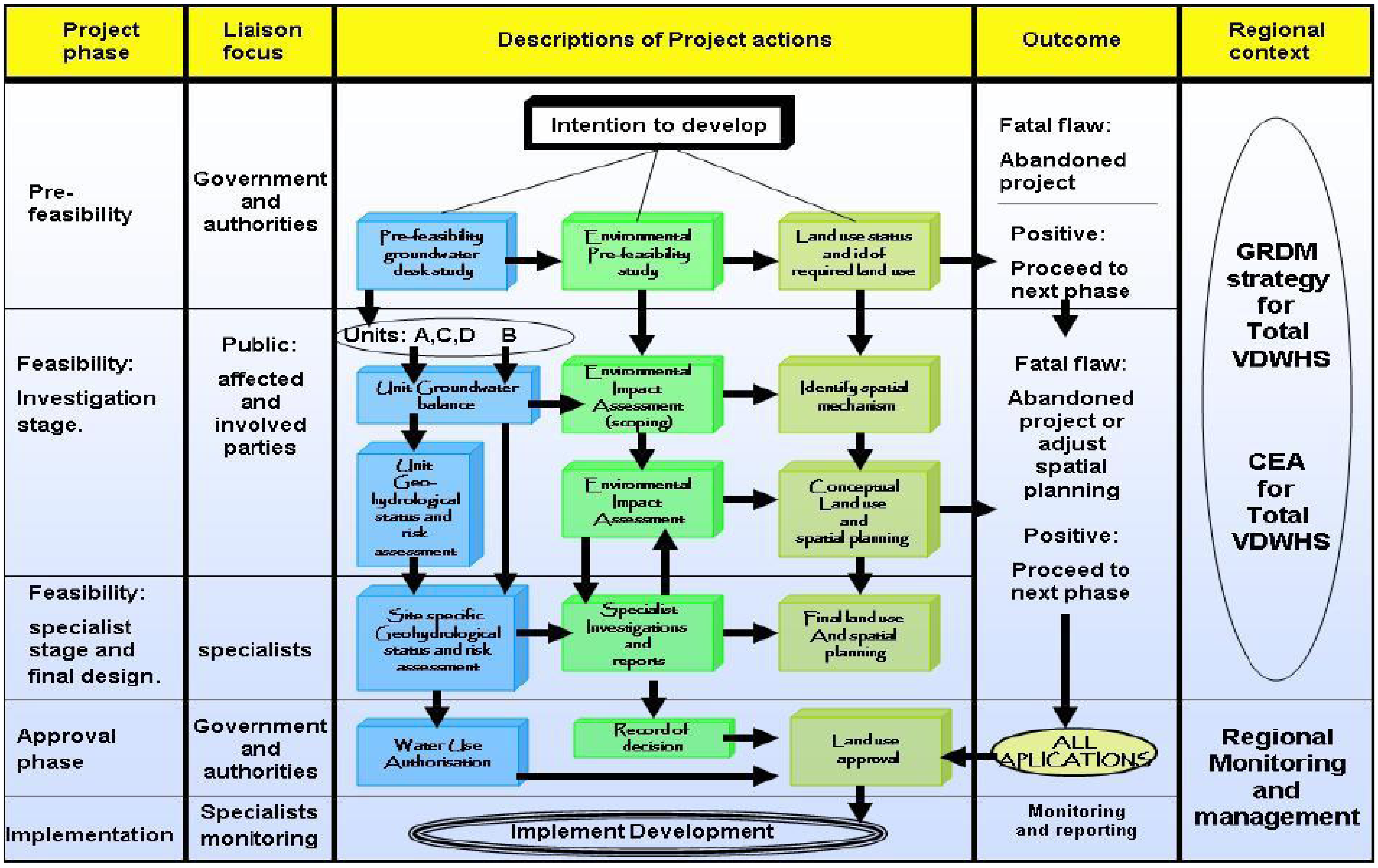
:1. Introduction
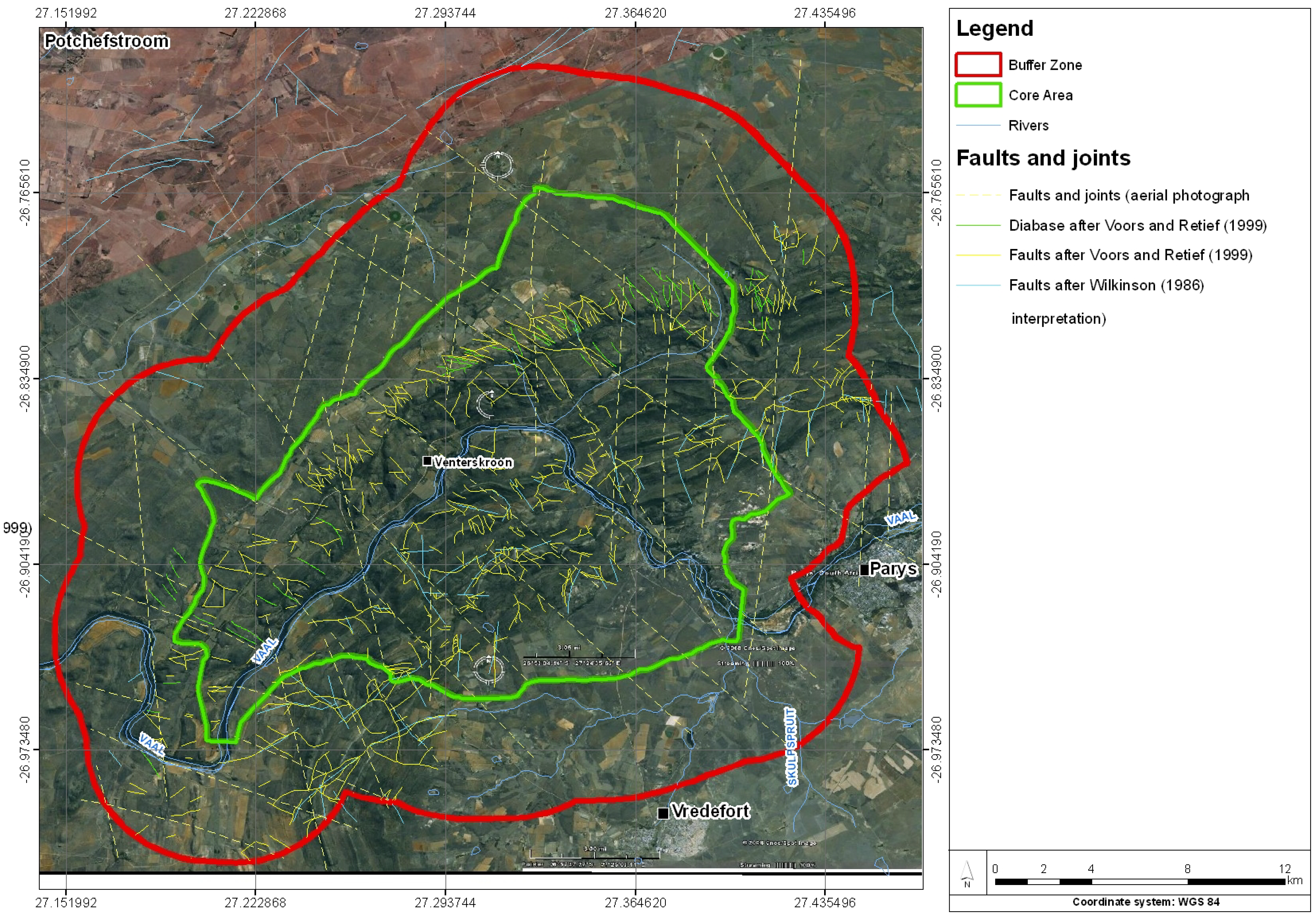
- The character of the geology and related groundwater aquifers: A higher groundwater potential is normally associated with fractured and non-homogeneous rocks, contact between two rock types of different competency associated with locally significant dykes and structural features.
- The availability of surface water and the potential recharge from surface water drainage: A higher groundwater potential is normally associated with areas where a higher level of interaction between surface water flow and aquifers occurs. However, virgin recharge as such is not the major factor in determining sustainability, but rather optimal yield. This is not a fixed value, but varies according to a range of given situations, necessitating the need for adaptive management [8].
- The existing groundwater practices and land uses within the area.

2. Research Method
2.1. Basis of Delineation
- Geological and structural geological setting: Specific aquifer systems acting as one resource and manageable unit are defined by the geological formations and their physical character reflecting depth and character of weathering.
- Geomorphological setting: Specific aquifer systems are defined by river valley development and hill formation throughout the VDWHS area.
- Aquifer characteristics as reflected by geohydrological parameters (water level from surface, water chemistry, and yield), and;
- Institutional reality and social structuring: This includes the borders of the VDWHS, and existing and expected development zones.
2.2. Geological Setting
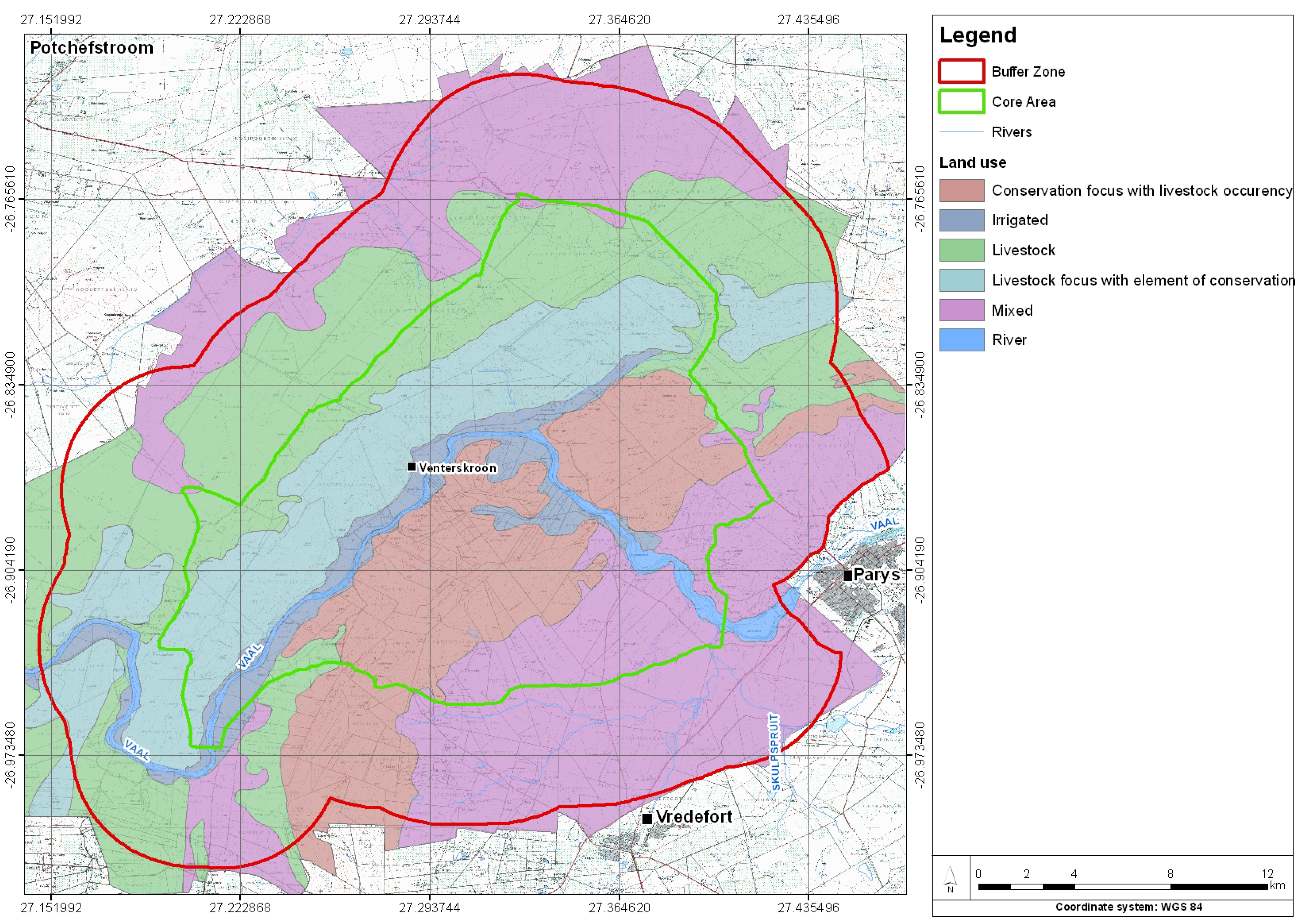
2.3. Land Use
- Mixed farming occurs where crop production is practiced commercially or to support the fodder flow of livestock. Small portions of land are planted under irrigation for winter grazing.
- Livestock farming occurs with the primary use of extensive animal production where fodder is provided during the harsh winter months.
- The combination conservation/livestock farming occurs in the central area of the VDWHS with a low grazing capacity and moderate to high browsing capacity. Conservation and game farming, integrated with livestock and tourism, are the preferred land uses. Two zones with a focus on either conservation or livestock are indicated in Figure 4.


2.4. Geohydrological Status Assessment
3. Results
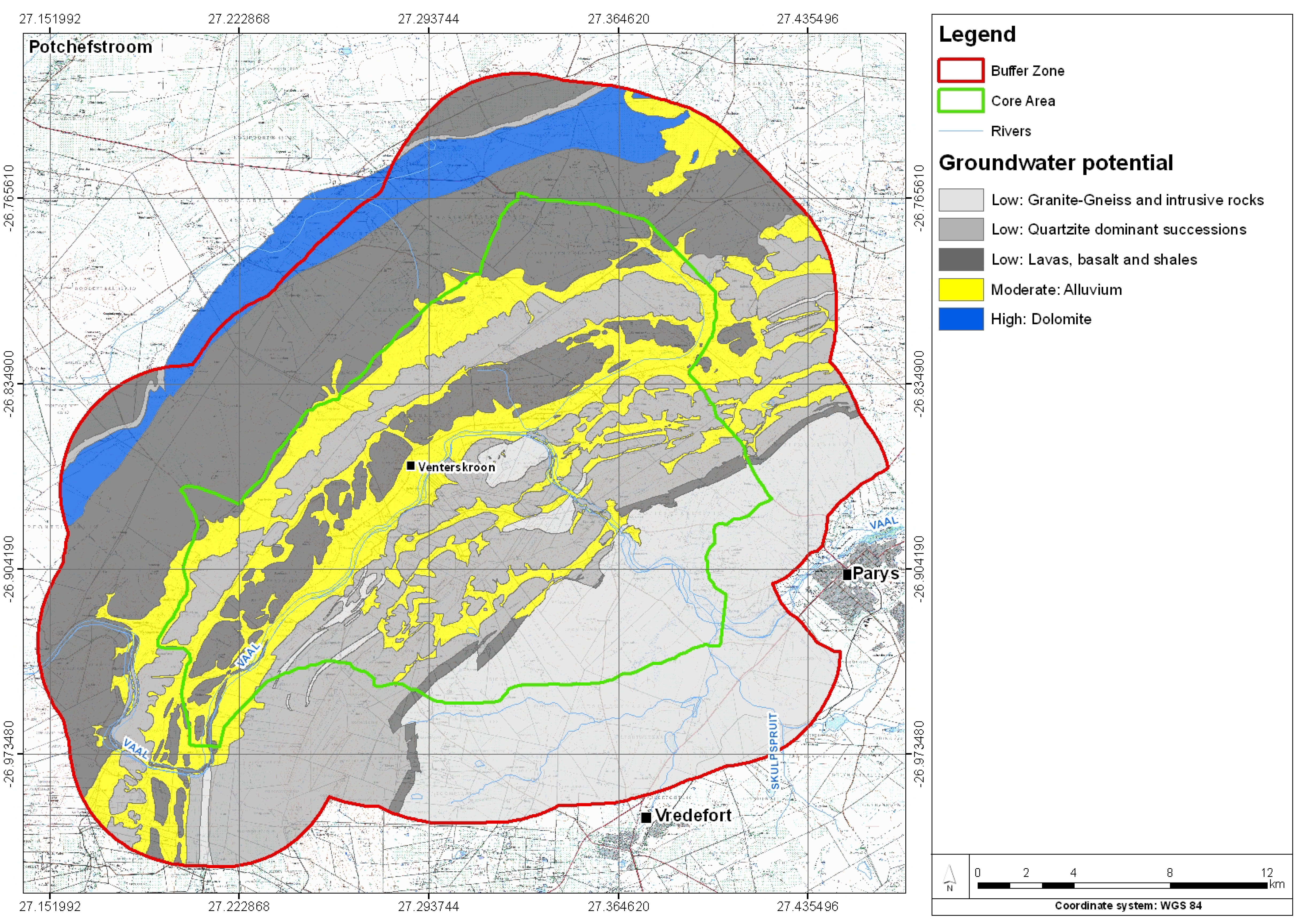
3.1. Groundwater Potential Zones
- Zone 1: Granite, gneiss and intrusive rocks exhibit a low groundwater potential with a recharge probability of 3–4% of mean annual precipitation (MAP) [34]. Local variation in texture occurs in the granites and gneisses of the hub of the VDWHS [20], giving rise to a variation in weathering. In combination with faults and dykes and the availability of surface water infiltration in drainage systems, specific zones within the granite present the possibility of borehole development.
- Zone 2: Quartzite dominated successions giving rise to the development of prominent hills throughout the study area and a low groundwater potential occur due to the near-surface bedrock [27]. A recharge probability of between 3–4% of the MAP is reported for quartzites from the Witwatersrand Supergroup [26]. Local linear aquifer development is typical of the quarts dominated successions associated with cracks and fissure zones along dykes, faults and shear zones [27]. A combination of the presence of an intergranular aquifer in overlaying alluvium and the availability of surface water infiltration, can give rise to localized higher potential zones in these areas.
- Zone 4: Alluvium and unconsolidated material and deeply weathered material typically associated with the surface drainage systems are considered areas of moderate groundwater potential. The deeper weathering increases not only the transmissivity, but also the storativity of the matrix, giving rise to the development of main aquifers in the valley fills. Although higher groundwater is expected in these areas, it is highly dependent on recharge and vulnerable to artificial change in balance [26]. Although the boreholes developed within the alluvium can be high yielding, they may have a lower sustainable yield since they are dependent on the rainfall, which is seasonal by nature.
- Zone 5: Dolomites from the Malmani subgroup have a moderate to high groundwater potential with a recharge potential of 6% of the MAP [26]. A local variation in weathering occurs in these rock types with chert and chert-breccia forming more weather-resistant zones [20]. Groundwater is stored and transmitted through cavities and fractures in the carbonate rock giving rise to a complex interaction of groundwater throughout the succession. From the complex structural geological character [27], it is evident that a complex network of faults, cracks and fissures along dykes and shear zones exist in the study area. This network gives rise to the development of linear secondary aquifers that may serve as conduits resulting in groundwater transfer from one to another catchment area and lithological unit. This geological character will give rise to a complex groundwater flow pattern which will significantly influence the geohydrological follow-up work and modeling.
3.2. Geohydrological Investigation
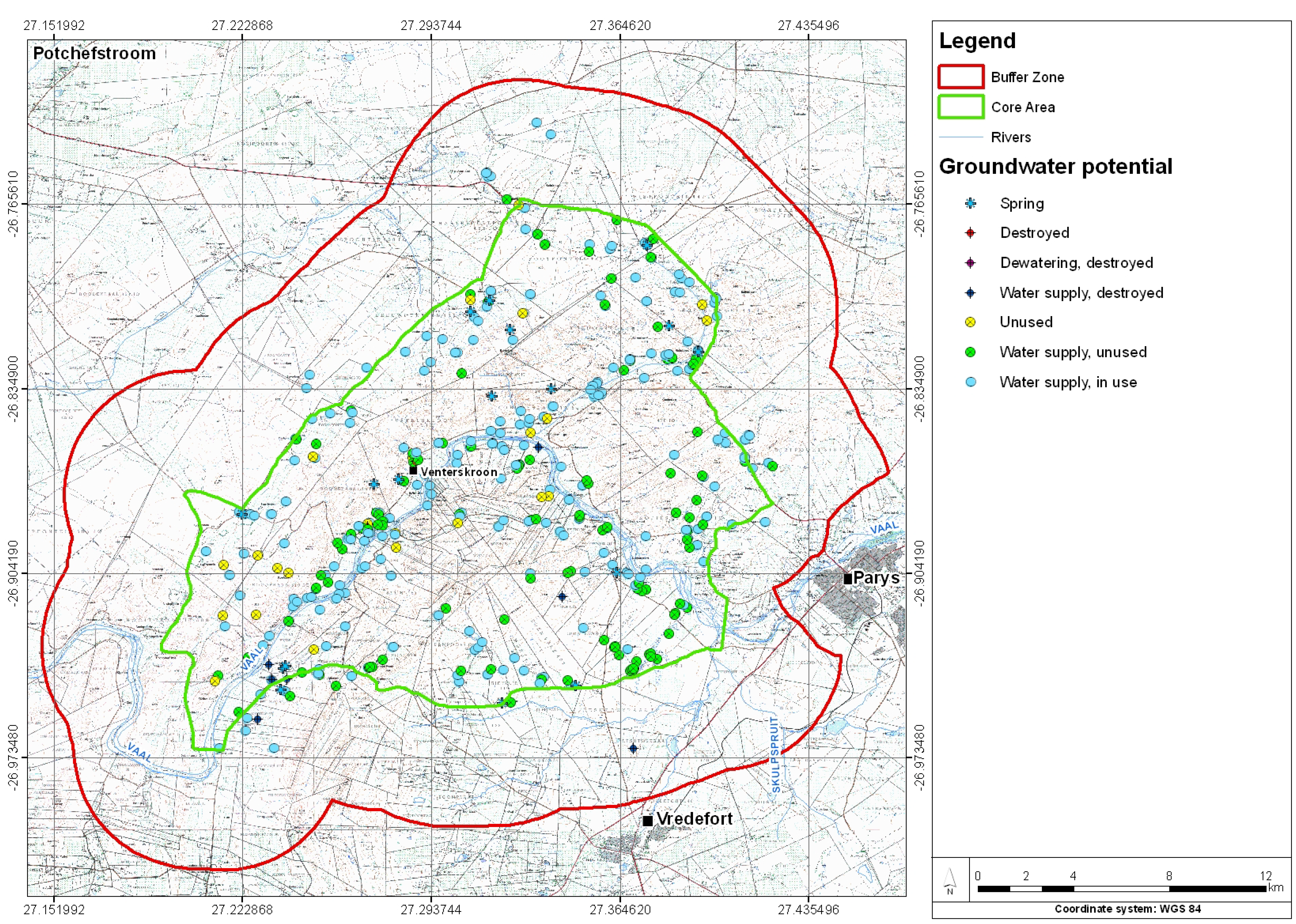
- Only 285 out of 460 surveyed boreholes and springs are operational (62%), 161 are not currently in use (35%) and 14 boreholes are deemed destroyed (3%). Of the operational boreholes, 32% are used for domestic purposes, 31% for both domestic use and livestock, 18% for stock watering and only 5% each for irrigation and a combination of agricultural and domestic use.
- Eighteen springs were identified in the study area during the geohydrological investigation. Eleven of these springs are used for stock watering or irrigation purposes. Some are uncovered and in some instances contaminated by carcasses and cattle manure. The springs are mostly associated with localized perched aquifer conditions within quaternary alluvium formations overlying a known deeper secondary linear aquifer system. The sustainability of the springs in the alluvium is expected to be low and recharge dependent as the near-surface character of bedrocks give rise to a shortage of groundwater [27]. A number of springs occur in shallow alluvium overlaying massive andesitic lava to the north and granites to the south.
- The number of boreholes and springs recorded which are not in use amount to 161. The majority of these boreholes are not used because their water source has dried up or the boreholes have collapsed. Some of the boreholes were identified to have poor quality water and the users decided to drill elsewhere for an alternative supply.
- Fourteen (14) destroyed boreholes were identified. These boreholes cannot be rehabilitated due to obstruction and collapse.
- The equipment of the boreholes is dominated by submersible pumps at 186 of the operational and equipped boreholes (65%). Wind pumps were the next most frequent occurring with 47 out of 285 equipped boreholes in use (16%) while positive replacement pumps were used in 25 cases (9%) and power-heads and other equipment in 27 cases (10%).
3.3. Water Levels and Flow Direction
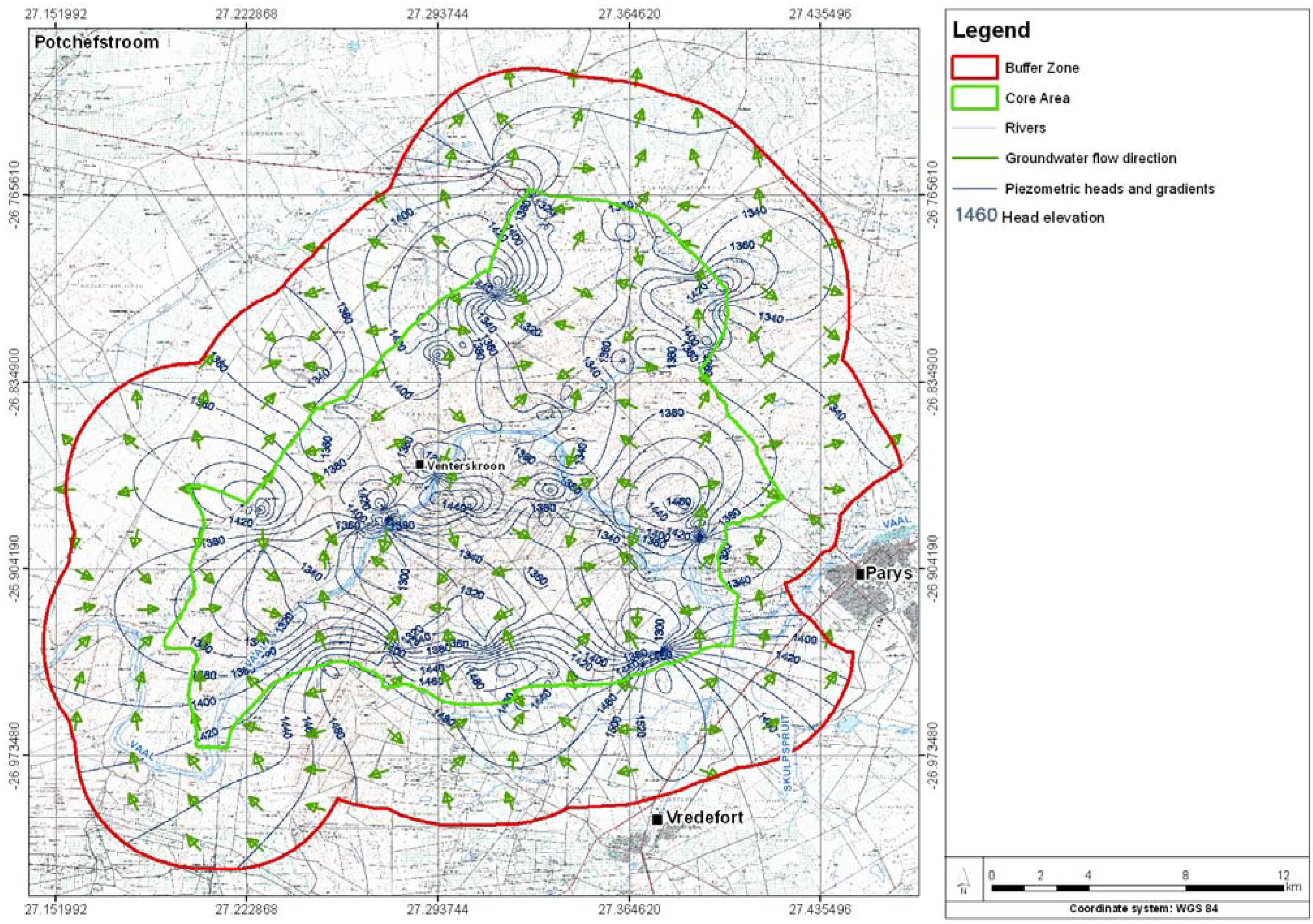
- Water levels follow a general northeast–southwest trend correlating with geological formations, giving rise to different zones in need for different management objectives.
- The Vaal River drainage system shows no effect on the groundwater level pattern. This indicates in general that recharge from surface water to groundwater from the Vaal River is restricted.
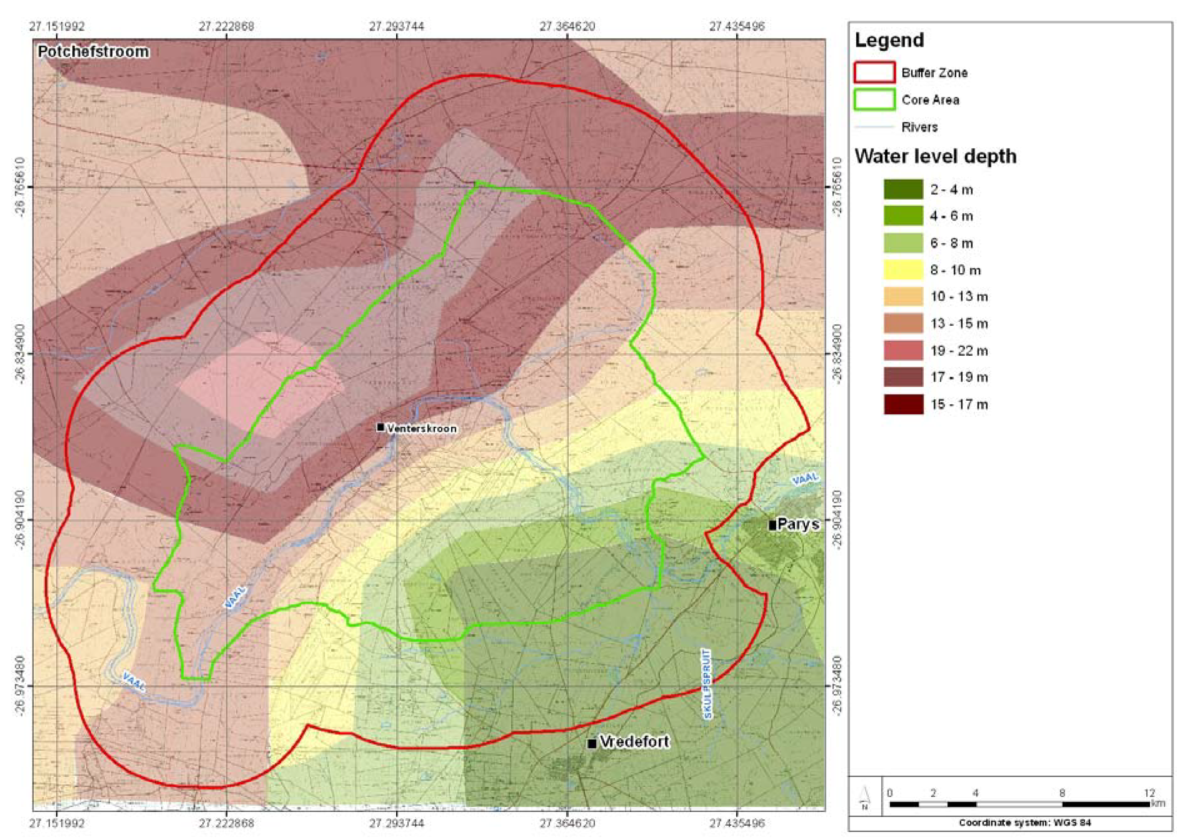
- The deepest water levels occur in the northwest of the VDWHS in the area underlain by andesite as part of the Ventersdorp Supergroup. This is probably caused by the low groundwater potential related to lavas and basalts and is indicative of the effect of local groundwater abstraction from the related aquifer with lower permeability and transmissivity. The authorization of any land use and groundwater related use activity in this area should therefore be based on a detailed geohydrological assessment of the area.
- The shallow water levels (2 to 4 meters) near the towns of Parys and Vredefort indicate that the groundwater aquifers in these areas are highly vulnerable to pollution and surface related activities. Any activities with a negative environmental impact like poorly designed and managed sewerage systems can have a severe influence on water quality and should be monitored and managed accordingly.


- Water abstraction from boreholes gives rise to local dewatering as an indication of the low critical balance in water demand and availability.
- Variation in flow directions is indicative of the effect of structural geology on the flow of groundwater within secondary linear aquifers throughout the study area.
- Groundwater flow follows the surface water flow direction with flow towards the Vaal River and tributaries in general. It is therefore apparent that the Vaal River is acting as an output for the underlying aquifers within the central and southeastern sections of the VDWHS.
- The groundwater flow moves against the flow of the Vaal River in the western parts of the VDWHS in the area underlain by lavas, basalts and shales. This indicates that that the river may be acting as a local input, or may be entirely disconnected from the aquifer.
- Groundwater flow crosses geological strata and confirms the existence of linear aquifers in the study area as described by Brink [27].
- Abstraction from boreholes gives rise to local dewatering and indicates the sensitive water balance in the study area.
- The groundwater flow patterns indicate that pollution of shallow aquifers within the VDWHS may contribute to the surface water pollution in the Vaal River. Additionally, a decrease in base flow with additional groundwater abstraction is likely.

3.4. Water Quality

| Element | Minimum | Maximum | Mean | Standard deviation | Allowable limits | ||
|---|---|---|---|---|---|---|---|
| Human consumption (mg/L) | Animal consumption (mg/L) | Irrigation (mg/L) | |||||
| Ca | 5 | 155.5 | 25.2 | 23 | 150 | 1,000 | - |
| Mg | 0.49 | 102 | 18 | 20.3 | 70 | 500 | - |
| K | 0 | 26.2 | 2.42 | 3.9 | 50 | - | - |
| Na | 0 | 235.6 | 23.5 | 28.5 | 200 | 2,000 | - |
| SO4 | 0.69 | 514.7 | 29.1 | 64.9 | 400 | 1,000 | - |
| NO3 | 0.2 | 169.9 | 19.5 | 27.8 | 10 | 100 | 5 |
| NH4 | 0.14 | 71.3 | 2.17 | 8.9 | 1 | - | - |
| Cl | 0.71 | 433.9 | 24.4 | 48.1 | 200 | 1,500 | 100 |
| HCO3 | 3.05 | 414.9 | 142.6 | 100.1 | - | - | - |
| pH | 5.49 | 8.35 | 7.16 | 0.57 | 5.0–9.5 | - | 6.5–8.4 |
| EC (mS/m) | 2 | 276 | 39.5 | 36.5 | 150 | - | - |
| TDS | 13 | 1794 | 257.1 | 237.3 | 450 | 1,000 | 40 |
| F | 0 | 5 | 0.07 | 0.51 | 1 | 2 | 2–15 |
| Mn | 0 | 2.71 | 0.06 | 0.28 | 100 | 10 | 0.02–10 |

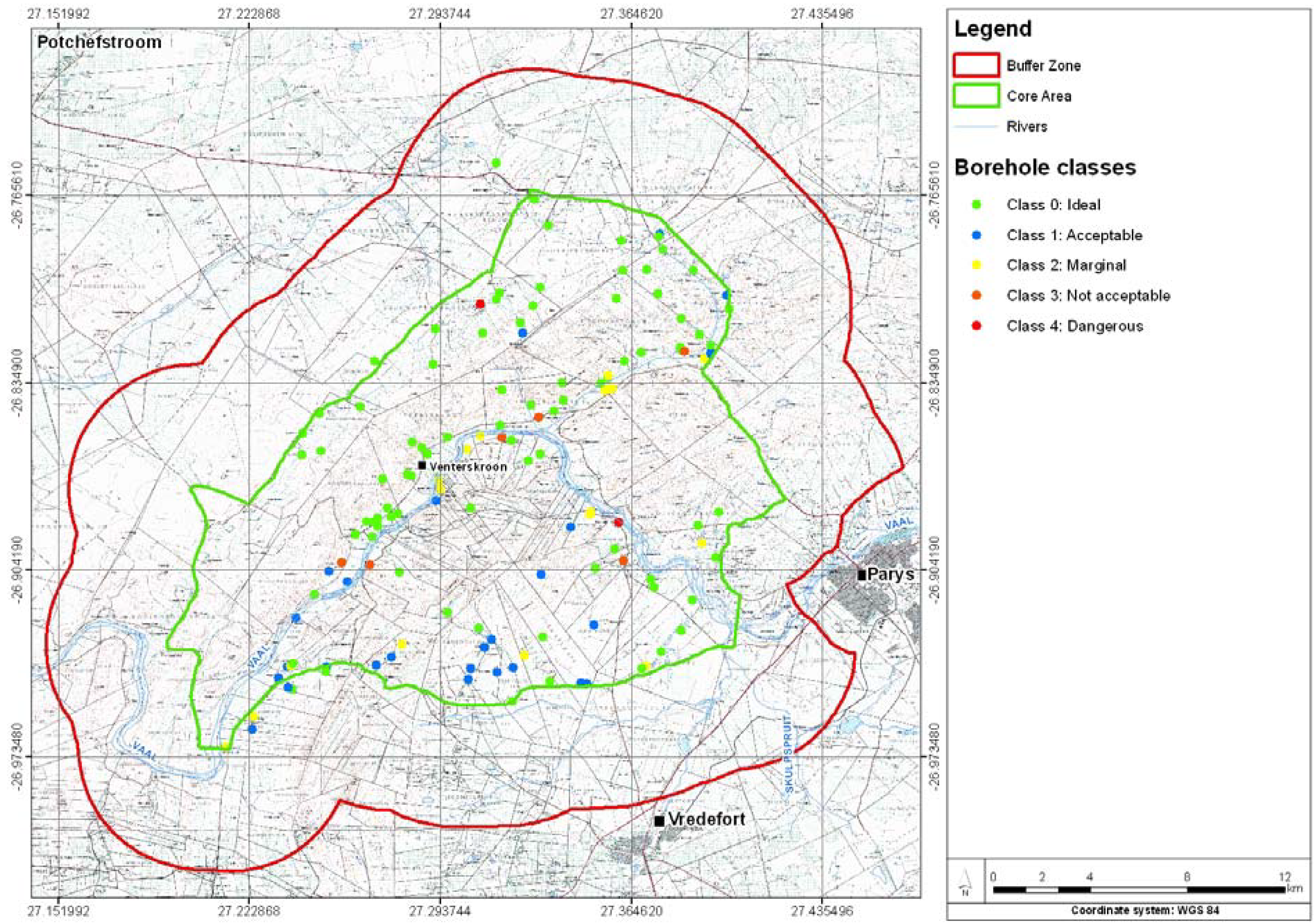
- The water quality in the majority of boreholes is acceptable with 84 out of 138 samples being classified as Class 0 or ideal against the drinking water standards. Added to this, another 28 samples were considered to be Class 1, which is also acceptable for drinking purposes under this standard. This means that 82% of the boreholes sampled have acceptable water quality.
- The 18% (n = 26) of the boreholes which are not considered as acceptable are indicative of local influences rather than a regional trend and need further investigation.
- A higher concentration of low quality groundwater (unsuitable for human consumption) is located within the Vaal River drainage system associated with shallow unconfined aquifers consisting of alluvium, sand, soil, gravel, and ferricrete with a high expected hydraulic conductivity. The water chemistry with typical nitrate of more than 50 mg/L and ammonia concentrations averaging 0.1 mg/L is indicative of pollution of groundwater from surface activities including decay of plant, animal and human waste. Direct causes may include high intensity land use activities such as poorly designed and managed septic tanks and/or high animal concentrations.
- The fluoride content of two of the samples are well above the recommended limit of 1.5 mg/L (3,12 and 5,15 mg/L) and are currently used for domestic purposes. High fluorite content was also reported from boreholes 3 km to the northwest from the VDWHS [6]. Fluoride is mostly brought into groundwater by leaching from minerals in rocks but may also be affected by chemical fertilizers in agricultural areas [37].
- The average TDS of boreholes in the VDWHS was 250 mg/L, pH neutral at 7.1 and chloride at 25 mg/L, which is acceptable.
3.5. Water Chemistry
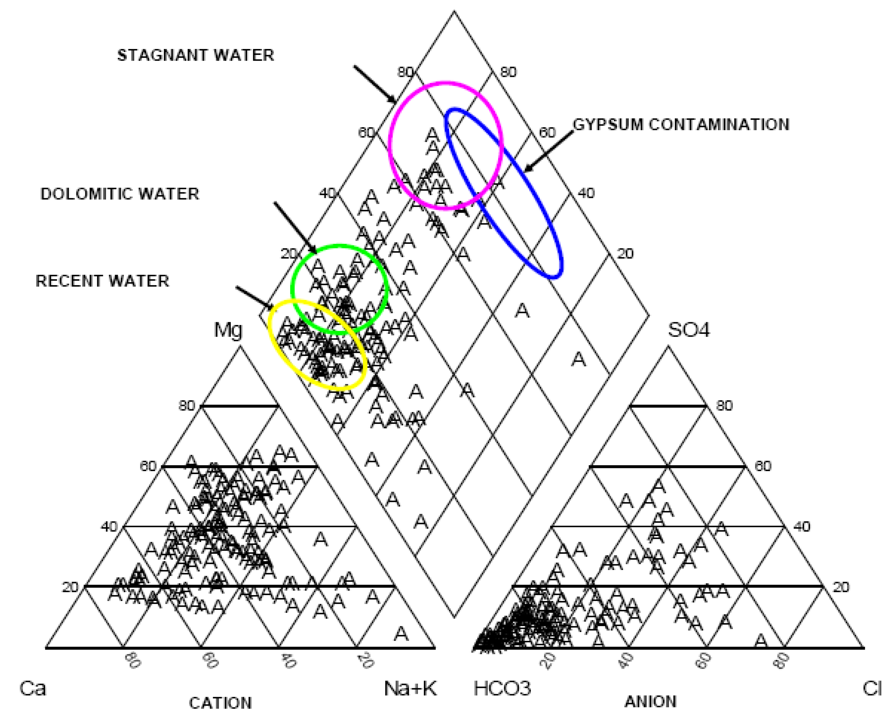
- The water types are dominated by calcium-magnesium-carbonate and the character of the water is very similar for all of the 138 samples analyzed.
- There is a high proportion of carbonate water with dominant HCO3 anion present. The cation domination is reflected on the left triangle of the diagram and indicates a domination of calcium and magnesium.
- The majority of the water sources appear to be recent. This means that there is a short delay or lag time between recharge and entry into the capture zone of the boreholes. The implication is that the water in the aquifers is not held in storage for very long and that the water is largely rainfall derived as opposed to seepage from surface water sources and deep aquifer circulation.

3.6. Groundwater Recharge
| mg/L | Recharge % | |
|---|---|---|
| Maximum | 434 | 0.2 |
| Minimum | 0.71 | 140 |
| Average | 24.87 | 4 |
| Standard deviation | 48.4 | 2 |
- The Groundwater Harvest Potential Maps of South Africa [33] indicated variability in recharge as one of the factors restricting the groundwater harvest potential.
- According to the geological and lithological character of the VDWHS, recharge may differ from 4% (granites) to 6% (dolomites) throughout the study area, with an estimated recharge of 7% in areas underlain by shale/quartzite successions [26].
- The recharge calculations for the Catchments C23C and C23L are given as 6.5% and 6.2%, respectively [26].
- According to national compilations the VDWHS falls within a recharge zone of 25–35 mm/a [26].
3.7. Groundwater Balance
- Recharge: The total surface of the core area of the VDWHS is 280 km². An annual rainfall estimation of 609 mm/a was obtained from the reserve determination tool as developed by the DWAF [25]. With an average recharge of in the order of 6%, a recharge volume in the order of 10,231 × 106 m³/a was calculated.
- Existing groundwater abstraction rates: The borehole survey was used to calculate the existing groundwater abstraction rates to a total of 4.352 × 10⁶ m³/a (Table 3).
| Equipment | Number | Estimate abstraction (L/S) | Pumping (hours/day) | Volume (m3/day) |
|---|---|---|---|---|
| Wind pumps | 54 | 0.8 | 16 | 2.5 |
| Mono type pumps | 25 | 2 | 12 | 2.1 |
| Submersible pumps | 186 | 1 | 12 | 8.0 |
| Springs | 19 | 1 | 24 | 1.6 |
| Estimated total (m3 per day) | 14, 325 | |||
| Estimated total (m3 per annum) | 5,228,669 | |||
- Base flow component: Based on maps by Vegter [11], and a reserve determination methodology developed by the DWAF [25], a base flow component of 4 mm/a is required for the catchments. For the total area of 280 km², calculated per day, this yields a volume in the order of 1.120 × 10⁶ m3/a––see Table 4.
- Basic human need: The official reserve determination is at this stage still outstanding and will play a critical role in the water balance calculation for the VDWHS and is therefore needed prior to any future development in the area. Currently, basic human needs are set by the Water Service Act (Act 108/1997) [39] at 25 liters per person per day (l/p/d). According to the borehole survey results in the order of 150 farming units exist in the core area, which correlate with the a total of 148 farms recorded [40]. For the present calculation the basic human need component of the reserve was estimated as 136 m3/day based on the number of farms in the study area. The Basic Human Need Calculation is shown in Table 5.
| Surface area (m2) | Minimum base flow (m) | Annual volume: base flow (m3) |
|---|---|---|
| 280,000,000 | 0.004 | 1,120,000 |
| Number of farms | 150 |
| Estimated number of people per farm | 8 |
| Total number of people | 1,200 |
| Reserve (liter per person per day) | 25 |
| Total annual basic need (m3) | 10,950 |
| Component | Inflow (m3/a) | Outflow m3/a) |
|---|---|---|
| Recharge | 6,820,800 | |
| Base flow | 1,120,000 | |
| Estimated current abstraction | 5,228,669 | |
| Basic human need | 10,950 | |
| Total | 6,820,800 | 6,359,619 |
| Balance (m3) | 461,181 | |
| Balance (%) | 7% |
4. Discussion
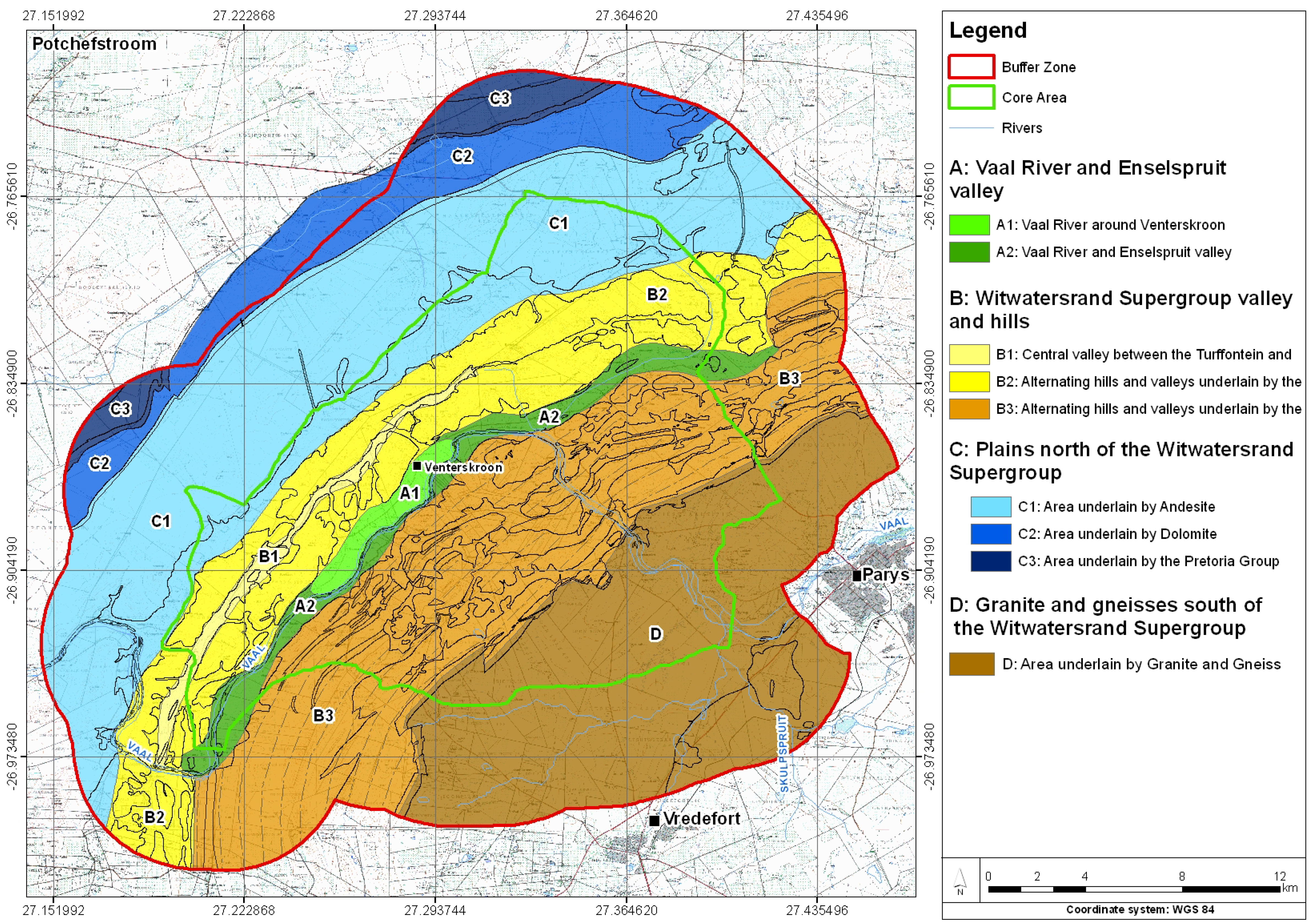
4.1. Description of the Different Groundwater Resource Management Units

4.1.1. Groundwater Resource Management Unit A: Vaal River and Enselspruit Valley
- Unit A1 comprises the area next to the Vaal River around the hamlet of Venterskroon. It consists of hills and outcrops surrounding a weathered valley area underlain by sand, soil, gravel, ferricrete, alluvial and weathered formations associated with the Vaal River drainage system. A total of 16 water samples from boreholes were analyzed, and water quality is generally good with the exception of two boreholes. The depth to the water table is 13–17 meters. Based on the fact that a state owned property which will be developed as an information center falls within this area, this area is likely to become the hub of future tourism activities. Due to the higher local permeability and transmissivity of the aquifer, potential development in the Venterskroon area may have a negative impact on the water quality. Special care should therefore be taken in the design and maintenance of sanitation systems at existing as well as new developments within the area. The approval of any individual land use change and related water rights must be based on a geohydrological impact assessment of Unit A1 as a whole. Such a study should include a detailed geohydrological status assessment, aquifer character investigation, experimental source development, modeling and risk analyses as well as a groundwater management plan.
- Unit A2 is the remainder of the Enselspruit and part of the Vaal River drainage system. It is underlain by sand, gravel, ferricretes, alluvium and weathered formations with a high permeability and transmissivity. A high density of development and tourism activity occurs along the river in this unit and it results in the lowest groundwater quality of all units in the VDWHS. Due to the high hydraulic conductivity, local contamination such as a leaking sewerage system may have a regional effect. The cumulative effect of all impacts has caused the low water quality in the area. Forty-five percent of the boreholes in this unit have elevated levels of N, Ca, Mg, SO4, Cl, HCO3, EC and TDS. A regional geohydrological study for any proposed development is therefore recommended for this unit (similar to Unit 1). Such studies should include strategies and methodologies to improve poor quality groundwater.
4.1.2. Groundwater Resource Management Unit B: Witwatersrand Supergroup Valleys and Hills
- Unit B1 comprises the central valley developed between the Turffontein Subgroup to the north and Johannesburg Subgroup to the south. This valley runs partially parallel with the Vaal River Valley (unit A1) and is the result of erosionally resistant quartzite horizons with shale found in the valleys [27]. A detailed delineation of the area indicates an interdependence with the linear aquifers developed in the adjacent quartziterich hills [27]. Groundwater levels in this valley are low, indicating that the aquifer is under stress. Hence, a detailed regional geohydrological assessment is needed for this unit prior to any further groundwater use.
- Unit B2 includes the rest of the alternating hills and valleys underlain by the Central Rand Group as a generalized combination of smaller locally developed aquifer systems with variations in character. This unit is underlain by variable geological formations of quartzites, shales, sedimentary successions and localized weathered zones stretching in a general northeasterly, southwesterly direction. Water levels and water quality differ from point to point throughout unit B2 due to the complex geological structure and character of the area. Thus, a regional geohydrological assessment of this area will be of a generalized nature and not of practical value from a management point of view. It is therefore recommended that any local land use application and related water right must be supported by a site specific geohydrological assessment to determine the parameters of each specific case.
- Unit B3 is underlain by the Jeppestown, Government and Hospital Hill Subgroups as part of the West Rand Group representing different locally developed aquifer systems. Rocks include undifferentiated successions of quartzite, sandstone, slate conglomerate, hornfels with politic beds stretching in a general northeasterly, southwesterly direction. As in Unit B2, water levels and water quality vary due to the complex geological structure and character of the area, and therefore site specific geohydrological impact assessments should be required for any land-use change applications.
4.1.3. Groundwater Resource Management Unit C: Plains North of the Witwatersrand Supergroup
- C1 is situated in the north and northwestern areas of the VDWHS underlain by andesite of the Klipriviersberg Group, Ventersdorp Supergroup. Water quality is generally good, especially in the area overlain with alluvium directly north of the Witwatersrand Supergroup, with the exception of a single borehole showing an elevated concentration of Fe. Nitrate (NO3), bicarbonate (HCO3), NH3, EC and TDS levels are low, indicating that this area is not sensitive to development activities. The water table in this unit is the deepest in the VDWHS, making it less vulnerable to pollution from land use activities.
- Unit C2 is underlain by Malmani dolomites to the north and northwest of the andesites. Because not much future development is expected in this unit, there is a reduced risk of groundwater contamination. However, this unit is of great importance to the VDWHS due to high yielding boreholes and good water quality. Land use applications in this unit are therefore regarded as a sensitive issue since development on dolomites increase the risk of sinkholes and interrupted natural surface drainage [42]. Ongoing monitoring and maintenance of water bearing services, as well as the implementation of precautionary measures relating to drainage and infiltration of surface water, are regarded as essential for developing any infrastructure on dolomites [43]. Due to the interaction between groundwater and stability in karstic areas, the assessment, planning and management of groundwater should be done in strict accordance with the guidelines from DWAF [26].
- Unit C3 comprises a small portion of the area underlain by rocks of the Pretoria Group. Rocks include quartzites, shale and andesite with a low groundwater potential, and no specific management measures are proposed.
4.1.4. Groundwater resource management Unit D: Granite and gneiss plains south of the Witwatersrand Supergroup
- Unit D represents the area south of the Witwatersrand Supergroup and forms the southern part of the VDWHS. The water table is very shallow resulting in the aquifer being vulnerable to pollution from surface activities. Land-use practices in this unit must take note of the vulnerability of the aquifer and special care must be taken to ensure appropriate sanitation and waste management practices.
5. Strategic Management Objectives
5.1. Water Balance
| Land use or utilization category | Figure for estimated demand | |
|---|---|---|
| 1 Development demand | ||
| Description of water supply | Consumption Liter /person/day | Consumption Liter/hectare/day |
| ⇒ Dwelling houses | 245 | |
| ⇒ Laborers’ houses | 150 | |
| ⇒ Guest houses | 280 | |
| ⇒ Conference facilities | 70 | |
| ⇒ Resorts | 215 | |
| ⇒ Business and commercial | 183 | |
| ⇒ Education facilities/ team building | 31 | |
| ⇒ Offices | 56 | 3,000 (Summer) |
| ⇒ Gardening and landscaping | 1,850 (winter) | |
| 35 (2 X per week) | ||
| ⇒ Churches | ||
| 105 | ||
| ⇒ Other buildings | 80 | |
| ⇒ Tourist (Day visitors) | ||
| 2 Agricultural demand | ||
| Description of water supply | ||
| ⇒ Surface irrigation (crops) | 500 to 1,000 | |
| ⇒ Sub-surface irrigation (crops) | 250 to 275 | |
| ⇒ Average agricultural demand | 80 to 150 | |
| ⇒ Horticulture | 3,000 to 3,500 | |
| ⇒ Cattle farming | 25 to 35 | |
| ⇒ Poultry | 25 to 25 | |
| ⇒ Small animal farming | 20 to 25 | |
| ⇒ Game farming | 15 to 20 | |
| ⇒ Other agriculture-related demand | 50 to 65 | |
5.2. Recharge Reduction
5.3. Sanitation
5.4. Surface Disposal of Waste
5.5. Vaal River Ingress
5.6. Sinkholes
5.7. Storm Water Management
5.8. Alien Vegetation
5.9. Application of Fertilizer
5.10. Institutional Framework

6. Conclusions
Acknowledgements
References
- IUCN. World Heritage Evaluation Report. Vredefort Dome South Africa. Available online: http://www.unep-wcmc.org/sites/wh/pdf/Vredefort%20dome.pdf 2004 (accessed on 12 September 2008).
- Puren, K.; Drewes, E.; Roos, V. An exploration of sense of place as informative for spatial planning guidelines: A case study of the Vredefort Dome world heritage site, South Africa. Int. J. Soc. Sci . 2007, 1, 190–197. [Google Scholar]
- AFRICAN EPA. Vredefort Dome Strategic Environmental Assessment. Internal Report Rendered to the Northwest Department of Agriculture and Tourism; Prepared by Consortium of Consultants under leadership of African EPA: Pretoria, South Africa, 2006. [Google Scholar]
- Van Tonder, G.; Dennis, I.; Vermeulen, D. The Importance of Constructing a Correct Conceptual Model for an Aquifer. In Proceedings of Water Resources of Arid Areas—Stephenson, Shemang & Chaoka; Taylor & Francis Group: London, UK, 2004. [Google Scholar]
- Scanlon, B.R.; Keese, K.E.; Flint, A.L.; Frint, L.E.; Gaye, C.G.; Edmunds, W.M.; Simmers, I. Global Synthesis of Groundwater Recharge in Semi-Arid and Arid Regions; Wiley: Hoboken, NJ, USA, 2006. Available online: www.interscience.wiley.com (accessed on 12 September 2008).
- Smit, J.J.; Pretorius, S.J. Geohydrological Assessment for the evaluation of groundwater for a proposed development on potion 5 of the farm Prinsloosrust 489 IQ in the Potchefstroom area, North West Province; Report 2008-02-05-GWSEAGES; Potchefstroom, South Africa, 2008. [Google Scholar]
- Braune, E. Towards a New Phase of Groundwater Reserve Assessment; Unedited working paper; Directorate Geohydrology Workshop: Pretoria, South Africa, 3 November 2000. [Google Scholar]
- Saayman, I. Guideline for Involving Hydro-Geologists in EIA Processes, 1st ed.; CSIR Report No ENV-S-C 2005 053 D; Provincial Government of the Western Cape, Department of Environmental Affairs and Development Planning: Cape Town, South Africa, 2005. [Google Scholar]
- Pearson, L.A.; Bhagwan, J.; Kariuki, W.; Banda, W. Guidelines on Appropriate Technologies for Water Supply and Sanitation in Developing Communities; WRC: Pretoria, South Africa, 2002. [Google Scholar]
- Botha, F.S.B. A Proposed Method to Implement a Groundwater Resource Information Project (GRIP) In Rural Communities, South Africa. Ph.D. Thesis, University of the Free State, Bloemfontein, South Africa, 2005. [Google Scholar]
- Vegter, J.R. Groundwater Development in South Africa and Introduction to the Hydrogeology of the Groundwater Regions; Water Research Commission: Pretoria, South Africa, 2001. [Google Scholar]
- Haupt, C.J. Explanation Sheet of the 1:500 000 Hydro Geological Map 2326 Pietersburg; WRC: Pretoria, South Africa, 2005. [Google Scholar]
- Baron, J.; Seward, P.; Seymour, A. The Groundwater Harvest Potential Map of The Republic of South Africa; DWAF: Pretoria, South Africa, 1996. [Google Scholar]
- Du Toit, W.H. Geohidrologie van die Nasionale Krugerwildtuin gebaseer op die evaluering van bestaande boorgat inligting; DWAF: Geohydrology, Pretoria, 1998; volume 1 and 2. [Google Scholar]
- Barnard, H.C. An Explanation of the 1:500 000 General Geohydrological Map, Johannesburg 2526; DWAF: Pretoria, South Africa, 2000. [Google Scholar]
- Vivier, J.C. Development of an Impact Assessment Methodology and Decision Making Tool to Assist in the Evaluation of Site Suitability for On-site Sanitation Sytems. Ph.D. Thesis, Potchefstroom Campus of the North West University, South Africa, 2006. [Google Scholar]
- Parsons, R.; Wentzel, J. Setting Resource Directed Measures (RDM) for Groundwater: A Pilot Study; WRC: Pretoria, South Africa, 2007. [Google Scholar]
- De, W.; Raath, C.J. Geohydrological Investigation of the Water Supply to the Proposed Zandrivierspoort Mine from Groundwater Sources; AGES: Potchefstroom, South Africa, 2008. [Google Scholar]
- Brink, M.C.; Bisschoff, A.A.; Waanders, F.B.; Schoch, A.E. The Vredefort Astrobleme and Similar Terrestrial Structures: A Comparative Analysis; North West University and University of the Free State: Bloemfontein, South Africa, 2005; (Addendum to the supplementary Information to the Vredefort Dome nomination dosser to UNESCO). [Google Scholar]
- Bisschoff, A.A. The Geology of the Vredefort Dome. Explanation of geological sheets 2627CA, CB, CC, CD, DA, DC, and 2727AA, AB, BA (1:50 000); Council for Geoscience, Geological Survey of South Africa: Pretoria, South Africa, 1999. [Google Scholar]
- Brink, M.C.; Bisschoff, A.A.; Waanders, F.B.; Schoch, A.E. The Geology of the Impact Structure around Vredefort; Department of Tourism, Environmental and Economic Affairs, Free State Province: Bloemfontein, South Africa, 2004; (Included as supplementary Information to the Vredefort Dome nomination dossier to UNESCO). [Google Scholar]
- Reimold, W.U.; Gibson, R.L. Meteorite Impact!: The Danger from Space and South Africa’s Mega-impact: The Vredefort Structure; Springer-Verlag: Heidelberg, Germany, 2010. [Google Scholar]
- Reimold, W.U.; Coney, L. The Vredefort Impact Structure and Directly Related Subjects: An Updated Bibliography; Economic geology research institute, University of the Witwatersrand: Johannesburg, South Africa, 2001. [Google Scholar]
- Lattman, L.H.; Ray, R.G. Aerial Photographs in Field Geology; Holt, Rinehart and Winston: New York, NY, USA, 1965. [Google Scholar]
- GRDM. Groundwater Resource Directed Measures: Version 2.5; Institute for Groundwater Studies, University of the Free State: Bloemfontein, South Africa; Department of Water Affairs and Forestry: Pretoria, South Africa, 2008. [Google Scholar]
- Groundwater Reserve Assessment II—task 3aE Recharge. Tender 2003-150 Final Report; Department of Water Affairs and Forestry: Pretoria, South Africa, 2006.
- Brink, M.C.; Waanders, F.B.; Bisschoff, A.A. The potential effect of prospecting or mining on the Vredefort Dome World Heritage Site. In Proceedings of the 2nd International Conference of Chemistry and the Environment; School of Chemical and Minerals Engineering, North-West University: Potchefstroom, South Africa, 2005; pp. 274–278. [Google Scholar]
- Parsons, R. A South African Aquifer System Management Classification; Water Research Commission: Pretoria, South Africa, 1995. [Google Scholar]
- Vegter, J.R. Groundwater Resources of the Republic of South Africa; WRC: Pretoria, South Africa, 1995. [Google Scholar]
- Desbarats, A.J.; Logan, C.E.; Hinton, M.J.; Sharpe, D.R. On the Kriging of water table elevations using collateral information from a digital elevation model. J. Hydrol. 2002, 255, 1–4. [Google Scholar] [CrossRef]
- Golden Software, 2002 Golden Software, Surfer 8. Contouring and 3D Surface Mapping for Scientists and Engineers. User’s guide. Golden Software, Inc.: Golden, CO, USA, 2002; p. 640.
- Quality of Domestic Water Supplies. Volume 2: Sampling guide; Department of Water Affairs and Forestry, Water Research Commission: Pretoria, South Africa, 2003b.
- Department of Water Affairs and Forestry. South African Water Quality Guidelines. Volume 1: Domestic, 2nd ed.; Department of Water Affairs and Forestry: Pretoria, South Africa, 1996. [Google Scholar]
- Quality of Domestic Water Supplies. DWAF and Water Research Commission, Volume 1: Assessment Guide, 2nd ed.; Department of Water Affairs and Forestry: Pretoria, South Africa, 1998.
- South African National Standards. Addition 6.1. South African National Standards 241: Drinking Water Standards; South African Bureau of Standards: Pretoria, South Africa, 2006. [Google Scholar]
- South African Water Quality Guidelines. Volume 4: Agricultural Water Use—Irrigation. Volume 5: Agricultural Water Use—Livestock Watering, 2nd ed.; Department of Water Affairs and Forestry: Pretoria, South Africa, 1996.
- Apello, C.A.J.; Postma, D. Geochemistry, Groundwater and Pollution; CRC: Pretoria, South Africa, 2005. [Google Scholar]
- Seward, P.; Xu, Y.; Brendonck, L. Sustainable groundwater use, the capture principle, and adaptive management. Water SA 2006, 32, 473–481. [Google Scholar]
- South Africa. Water Services Act no. 108 of 1997; Government Gazette 390; 1997.
- Du Pisani, J.A. Cultural Heritage Plan. In AGES, 2007 Vredefort Dome World Heritage Site: Integrated Management Plan. Internal Final Draft report no. 31-3-2007; Department of Tourism Environment and Economic Affairs, Free State Province: Bloemfontein, South Africa, 2005. [Google Scholar]
- Groundwater Protocol. Summary Version. Protocol for the Protection of Groundwater from Contamination from Sanitation Practices, Version 2; Department of Water Affairs and Forestry: Pretoria, South Africa, 2003.
- Pretorius, S.J.; Hattingh, A.M. Geo-Environmental Assessment of Mining Related Urban Development. In Planning and Development perspectives for Mining Towns in South Africa Conference; Northwest University: Potchefstroom, South Africa, 2008. [Google Scholar]
- De Bruyn, I.A.; Bell, F.G. The occurrence of sinkholes and subsidence depressions in the far west Rand and Gauteng Province, South Africa, and their engineering implications. Environ. Eng. Geosci. 2001, 7, 281–295. [Google Scholar] [CrossRef]
- Heath, R.C. Basic Ground-Water Hydrology: U.S. Geological Survey Water-Supply Paper 2220; Open File Service Section: Denver, CO, USA, 2004. [Google Scholar]
- Development, Maintenance and Management of Groundwater Resources; South African National Standards: Pretoria, South Africa, 2002; Parts 1-2, 4-9.
- Wright, K.A.; Xu, Y. A water balance approach to the sustainable management of groundwater in South Africa. Water SA 2000, 26, 167–170. [Google Scholar]
- Le Maitre, D.C.; Scott, D.F.; Colvin, C. A review of information on interaction between vegetation and groundwater. Water SA 1999, 25, 137–152. [Google Scholar]
- Kidd, M. EIA’s and the four P’s: Some observations in South Africa. In Land Use Law for Sustainable Development; Cambridge University: New York, NY, USA, 2007. [Google Scholar]
- South Africa. National Water Act, Act no. 36 of 1998; Government Gazette 398; 1998.
© 2010 by the authors; licensee MDPI, Basel, Switzerland. This article is an open access article distributed under the terms and conditions of the Creative Commons Attribution license (http://creativecommons.org/licenses/by/3.0/).
Share and Cite
Walt, I.J.v.d.; Pretorius, S.J.; Schoeman, C.B. The Role of Geohydrology in the Determination of a Spatial Development Framework in the Vredefort Dome World Heritage Site. Water 2010, 2, 742-772. https://doi.org/10.3390/w2040742
Walt IJvd, Pretorius SJ, Schoeman CB. The Role of Geohydrology in the Determination of a Spatial Development Framework in the Vredefort Dome World Heritage Site. Water. 2010; 2(4):742-772. https://doi.org/10.3390/w2040742
Chicago/Turabian StyleWalt, Izak J. van der, Stephanus J. Pretorius, and Carel B. Schoeman. 2010. "The Role of Geohydrology in the Determination of a Spatial Development Framework in the Vredefort Dome World Heritage Site" Water 2, no. 4: 742-772. https://doi.org/10.3390/w2040742