Article

Neglected Canals: Deterioration of Indigenous Irrigation System by Urbanization in the West Peri-Urban Area of Bangkok Metropolitan Region

1
Graduate School of Frontier Sciences, University of Tokyo, 5-1-5 Kashiwanoha, Kashiwa City, Chiba 277-8561, Japan
2
Department of Environmental Systems, Wakayama University, 930 Sakaedani, Wakayama City, Wakayama 640-8510, Japan
*
Author to whom correspondence should be addressed.
Water 2012, 4(1), 12-27; https://doi.org/10.3390/w4010012
Submission received: 20 October 2011 / Revised: 7 December 2011 / Accepted: 21 December 2011 / Published: 9 January 2012

Abstract

:
This paper discusses the deterioration of indigenous irrigation system traditionally developed in the past to serve the peri-urban agricultural lands that have been affected by rapid urbanization in the Bangkok Metropolitan Region. The study is based on data collection from mapping, field survey and interview analyses and identifies current canal deteriorating conditions in four categories: filled, covered, narrowed and shallow, and normal. The findings reveal that different types of canal deteriorations are associated with their private ownership. A typology of land configurations of urban and non-urban land uses along private canals is pointed out in order to understand their relation with canal deterioration types. Caused by urbanization, the degradation of the existing canal networks has provoked conflicts between local farmers and new proprietors, especially real estate developers. Such canal deterioration essentially reduces their ability to convey a water supply to feed agricultural lands, consequently leading to the discontinuation of land use for agriculture and its eventual transformation into urban developments.

1. Introduction

Water is one of the most fundamental concerns for farming especially in terms of cultivation and development to make higher quality agricultural lands. Since the early times, man started to appreciate the possibility of agriculture on dry lands by collecting water as a source of supply instead of depending only on on-the-spot natural rainfall. Landscapes were accordingly manipulated mainly for the irrigation purpose [1]. As a part of this irrigation system to supply agriculture, canals were excavated in a small scale, using basic local technology and simple maintenance executed by individuals or groups of neighbors [1]. This traditional system is known as “Indigenous irrigation system” [2,3,4]. It presents a contrasting approach to the modern irrigation system which has been developed for supplying large-scale agriculture. In order to develop and manage this large-scale irrigation system, an organization of hydraulic society is formed and centrally controlled by the government, according to Wittfogels’ hydraulic civilization theory. More than three-quarters of indigenous irrigation systems found around the world are located in Asia [2]. Their long development and improvement over time have seen a well-balanced combination of physical features and management software of local communities which proves the success of the indigenous irrigation systems to conform with and adapt to local environments [2].
Wherever urbanization takes place, local irrigation systems are usually affected, especially in the peri-urban area where urban and agricultural land uses are mixed. It is usual to expect an emergence of certain types of problems, for example water pollution, canal deterioration and even a total destruction of irrigation systems [5]. However, in the case of the modern irrigation systems, in general, these problems are monitored and appropriately resolved by certain governmental agencies in-charge. In contrast, the indigenous irrigation systems in which management solely depends on local community are easily neglected, especially when traditional social and economic relationships within the community are altered by urbanization. As the strength of the community declines, the traditional mechanism to service community needs and resolve local conflicts becomes unreliable [6].
Bangkok, the capital city of Thailand, enjoyed rapid urbanization during the late twentieth century [7,8]. According to the rapid economic growth and population increase since the 1980s, urbanization has spread out into surrounding provinces and formed one of the largest mega-urban regions in Southeast Asia, the “Bangkok Metropolitan Region” (BMR) [9,10]. The BMR is located in the low-lying floodplain of the Chao Phraya Delta in which rich alluvial soil and an abundance of water make the area suitable for agriculture [11,12]. Canal networks were continuously constructed in the BMR in the form of both indigenous and modern irrigation systems mainly to serve agriculture and transportation [13,14,15,16]. Canals in the indigenous irrigation system had been dug earlier in the western areas of the BMR, while modern irrigation system was constructed later in the eastern areas (Figure 1). Invaded by urban development, Bangkok, which was once a water-based city, has become a land-based city. As a result, its canals have gradually deteriorated and become neglected by urbanites [17,18]. New urbanization, i.e., housing estates led by a road network, have been developed through land filling and damaging the existing irrigation systems, currently in the peri-urban area [19,20]. These canal deteriorations not only generate environmental problems but also create social conflicts [19].
Figure 1. Map of the “Bangkok Metropolitan Region” (BMR) area served by indigenous and modern irrigation systems in Chao Phraya Delta (Adapted from Pollution Control Department, Thailand [21]).
Water 04 00012 g001
Many previous studies by scholars and government agencies, for example, Bangkok Metropolitan Administration (BMA), Department of Pollution Control, and National Environmental Board, have been conducted to monitor and resolve problems related to water pollution and irrigation system deterioration caused by urbanization mainly in the Bangkok Metropolis [22]. Research studies by many other scholars gave emphasis to BMR’s peri-urban area to examine urban sprawl and its impact in which irrigation system deterioration is included [20,23,24]. One particular study conducted by Sajor and Ongsakul focused directly on the water system. The researchers selected the northeast peri-urban area of Bangkok as a study area to address the impact of urbanization to the water system in terms of governance [25]. However, like many others, the irrigation system used to serve this area is the modern type. Specific studies on deterioration of indigenous irrigation system caused by urbanization are still lacking.
Indigenous irrigation system has played an important role in agricultural land transformation in the peri-urban area of BMR. There are two interconnected processes that appear to occur, affect the other and return like a cycle (Figure 2). When agricultural lands are invaded by new developments, canal deterioration is one of the problematic issues stimulated by the urbanization. The deterioration of irrigation systems brings about the termination of farming and gives rise to more urbanization. The latter process has been examined and proved by our previous study [26]. However, the former process has not been studied in detail yet.
Figure 2. Diagram of urbanization processes in BMR’s peri-urban area. (A*) Urbanization on agricultural land induces irrigation system deterioration (main discussion issue of this paper); (B) Irrigation system deterioration induces urbanization on agricultural land.
Water 04 00012 g002
Issues regarding canal deterioration in various types have been raised among local farmers, including the weakness of indigenous irrigation system caused by canal ownership, especially “canal filling”. Even though canal water is regarded as a free and open access resource [27], the conveyer itself has public-private rights over it. Canals situated in properties owned by the government are regarded as “public canals”, while canals situated in lands that belong to individuals or private sectors are considered “private canals”. The rights to manage canals legally belong to owners of the properties where the canals are situated. Likewise, in the case of urbanized lands, real estate developers who purchase the lands could claim the rights of the canal within their properties. They are entitled to take any action within their lands, including canal filling, which is accordingly considered legal. However, regardless of its importance, the influence of canal ownership on the deterioration of canals is overlooked by administrators or policy makers and has never carefully been studied. This issue requires further investigation.
Therefore, this paper aims to investigate deterioration of indigenous irrigation system by urbanization through three steps. First, it examines the effect of urbanization on canal deterioration. What types of canal deterioration have occurred? Secondly, it examines the effect of public-private canal ownership on the canal deterioration. How different types of canal deterioration correlate with canal ownership? Thirdly, it identifies typology of land configuration in relationship to the deterioration of private canals. How the deterioration of private canals is spatially related to configuration of urban and non-urban land uses?

2. Study Area and Methods
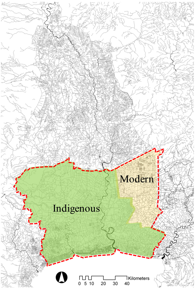
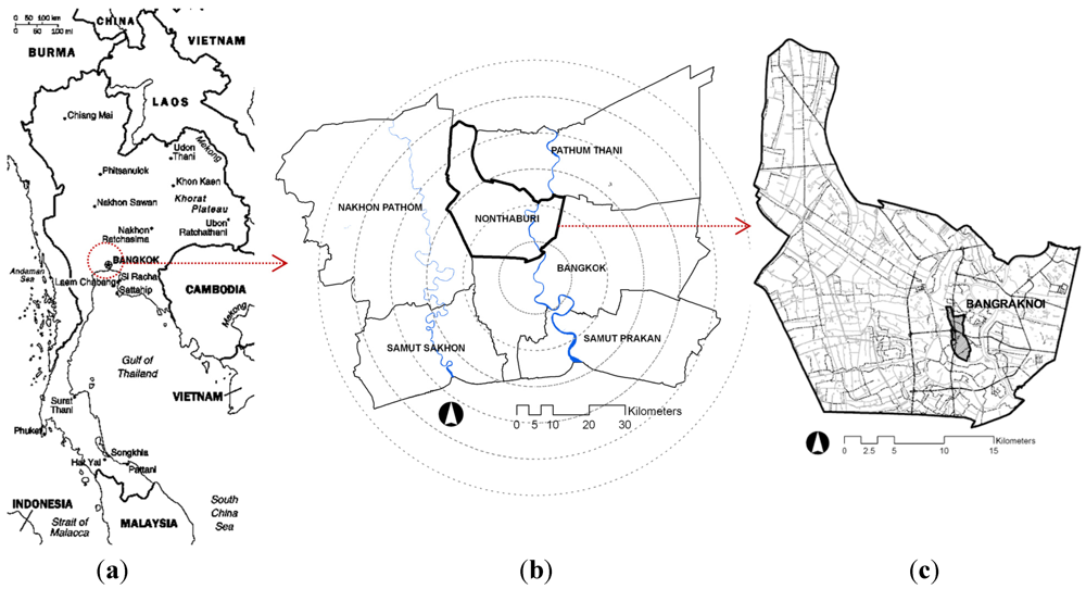
2.1. Study Area

The study focuses on Nonthaburi, a province in Thailand located to the northwest of Bangkok and one of the fastest urbanizing provinces in BMR [28] which consists of Bangkok and five surrounding provinces, i.e., Nonthaburi, Pathumthani, Nakhon Pathom, Samut Sakhon, and Samut Prakan [9] (Figure 3a and b). Bangraknoi sub-district is selected as a case study representing a typical pattern of urbanization in Nonthaburi, in order to explain deteriorations of canals in the indigenous irrigation system caused by urbanization (Figure 3c).
Figure 3. Study area (a) Map of Thailand (Adapted from US-CIA [29]); (b) Map of Bangkok Metropolitan Region; (c) Map of Nonthaburi Province indicates the location of Bangraknoi sub-district.
Water 04 00012 g003
Bangraknoi sub-district encompasses an area of 5.8 km2 and a total population of 18,475. Around two-thirds of its area is agricultural land mainly comprising poldered raised bed orchards and paddy fields. The other one-third is formed by more developed areas mostly used for residential purposes [30]. While urban areas have continued to spread out due to growing needs and favors, land use for agriculture has declined. The Maenam Orm and Bang Bua Thong canals are the main waterways that supply water to agricultural lands in Bangraknoi. However, they no longer serve as the main transportation means. Owing to urban sprawl centered in Bangkok, infrastructure systems including road networks have been expanding to cover suburban zones, and so have the booming real estate developments in the area.

2.2. Methods

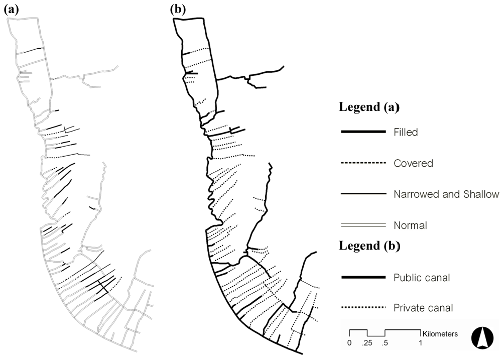
2.2.1. Examination of the Relationship of Urbanization and Canal Deterioration

In order to prove a causal relationship between urbanization and canal deterioration, urban land use and canal deterioration were physically examined for their correlation. The analysis mainly focused on canal deterioration that affects its ability to convey water. Several methods were used to collect relevant data. First of all, data on canal deterioration were gathered through field surveys. Canal maps acquired from Bangraknoi Sub-district Administration Organization (Bangraknoi SAO, Nonthaburi, Thailand) [31] (Table 1) and handheld GPS unit were used as to assist in the field survey. Interviews with local people were also a means to locate and identify many filled canals. Research findings revealed different canal conditions which can be identified in four types, from the most deteriorated to normal conditions respectively: (1) filled canals, (2) covered canals, (3) narrowed and shallow canals, and (4) normal canals (Figure 4).
Table 1. Collected data.
DataSourcesReference
Canal map Bangraknoi Sub-district Administration Organization (Bangraknoi SAO)[31]
Satellite images 2010 (THEOS)Geo-Informatics and Space Technology Development Agency (GISTDA)[32]
Cadastral map (GIS data)Nonthaburi Provincial Administrative Organization (Nonthaburi PAO)[33]
Figure 4. Types of canal deterioration. (a) Filled canal; (b) Covered canal; (c) Narrowed and Shallow canal; (d) Normal canal.
Water 04 00012 g004
Filled canals are defined by full canal blockage by natural sedimentation or land filling. For covered canals, hard surfaces have been overlaid in order to utilize the land above the canal; therefore the canal underneath still functions as a water conveyer. Piping is also included in this category. The narrowed and shallow type refers to conditions where canals are partly blocked through natural sedimentation or land filling. Normal canals are considered the least disrupted type with minimum apparent transformation. Original physical dimensions and functions of canals are still maintained. However, water quality deterioration, i.e., water pollution, is included in this category. A map of canal deterioration was created from this data using ArcGIS software. Then, a land use map in 2010 was created through a manual interpretation of a THEOS satellite image obtained from the Geo-Informatics and Space Technology Development Agency (GISTDA, Bangkok, Thailand) [32] (Table 1), which divided land uses into two main categories: urban and non-urban land uses. The urban land use includes built up land, cleared land ready for construction and infrastructure for urban development, i.e., highways. The rest of the areas is categorized as non-urban land use, in which the main part consists of agricultural lands. For the final step, the canal deterioration map was spatially analyzed with the land use map in 2010 using ArcGIS software. In addition to the identification of four types of deteriorated canals, the quantity of the canals in each type were summarized and compared in terms of length and percentage based on their location inside and outside urban land.

2.2.2. Examination of Relationship Between Canal Deterioration and Public-Private Ownership of Canals

In order to prove a causal relationship of canal deterioration and public-private ownership of canals, different types of canal deterioration and different types of canal ownership, i.e., public and private properties were physically examined. First, canals in Bangraknoi sub-district were categorized into public and private canals by superimposing of a cadastral map obtained from Nonthaburi Provincial Administration Organization (Nonthaburi PAO, Thailand) [33] (Table 1) and a canal map using ArcGIS software. Then, canal maps identified by types of canal ownership and deterioration were superimposed and analyzed (Figure 5). The quantity of deteriorated canals in each type were summarized and compared in terms of length and percentage based on their ownership type.
Figure 5. Canal maps in Bangraknoi sub-district, Nonthaburi, Thailand. (a) Canal identified by types of deterioration; (b) Canal identified by public-private ownership.
Water 04 00012 g005

2.2.3. Identifying Typology of Land Configurations in Relationship with Deterioration of Private Canals

Indigenous irrigation system is comprised of public and private canals. Ownership of a private canal is divided along the property line in the middle of canal. If lands on both sides of the canal belong to the same owner, the proprietor is entitled to claim sole ownership of the canal. However, if the land on each side is owned by a different proprietor, they share ownership of the canal. This fact results in several patterns of land use on either side of the canal and canal conditions. The configuration of land uses along the canal side i.e., urban and non-urban, are assumed to affect the deterioration of private canals. Based on this spatial structure of canal ownership, typology of land configurations were identified in relationship to deterioration of private canals. Land use along each type of canal deterioration was observed by superimposing a canal deterioration map, a canal ownership map, a land use map, and a satellite image in 2010 using ArcGIS. Field surveys and interviews with local people were conducted to clarify canal deterioration and land configurations.

3. Results

3.1. Relationship of Urbanization and Canal Deterioration

The results revealed a correlation of urbanization and canal deterioration in Bangraknoi sub-district. Different types of canal deteriorations are found inside and outside the urbanized area. Most of the canal deteriorations such as filled and covered canals are found inside urbanized areas. 77.61% or 3,857 m of filled canals are found inside urbanized areas, while only 22.39% (1,113 m) are located outside. Similar to the canal filling type, 77.90% (1,512 m) of covered canals are found inside urbanized areas, while only 22.1% (429 m) are found outside the areas. In contrast, canals in narrowed and shallow conditions and normal conditions are mostly found outside urbanized areas, that is 93.86% (2,933 m) for narrowed and shallow canals and 94.81% (29,526 m) for normal canals (Figure 6, Table 2).
Figure 6. Percentage of canal deterioration located inside and outside urbanized area.
Water 04 00012 g006
Table 2. Length of canal deterioration located inside and outside urbanized areas.
Canal types by locationCanal deterioration
Filled (m)Covered (m)Narrowed & shallow (m)Normal (m)
Canal inside urbanized area3,8571,5121921,615
Canal outside urbanized area1,1134292,93329,526
Total4,9701,9413,12530,594

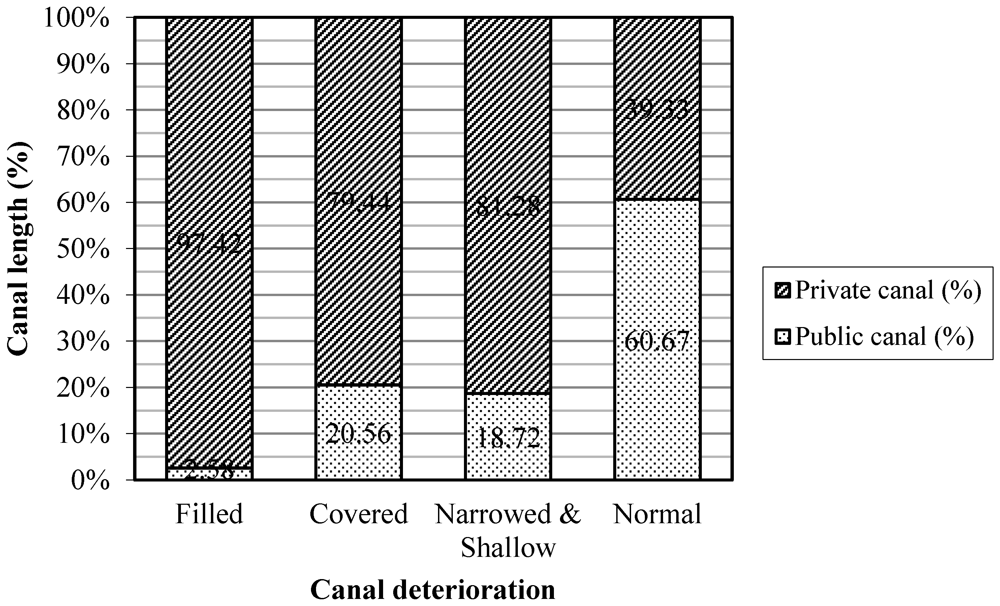
3.2. Relationship of Canal Deterioration and Public-Private Ownership of Canals

The result revealed that most canals in filled, covered, and narrowed and shallow conditions occur with private canals. For canal filling, 97.42% (4,842 m) of filled canals are private, while only 2.58% (128 m) are public. For canal covering, 79.44% (1,542 m) of covered canals are private, while only 20.56% (399 m) are public. Likewise, 81.28% (2,540 m) of narrowed and shallow canals are private, while only 18.72% (585 m) are public. In contrast, the majority of canals in normal conditions are public properties (60.67%, 18,560 m). These results confirmed that private canals are highly vulnerable to deterioration. In other words, canal deterioration is associated with the private ownership of canals (Figure 7, Table 3).
Figure 7. Percentage of canal deterioration in relationship to public-private ownership of canals.
Water 04 00012 g007
Table 3. Length of canal deterioration in relationship to public-private ownership of canals.
Canal ownershipCanal deterioration
Filled (m)Covered (m)Narrowed & shallow (m)Normal (m)
Public canal12839958518,560
Private canal4,8421,5422,54012,034
Total4,9701,9413,12530,594

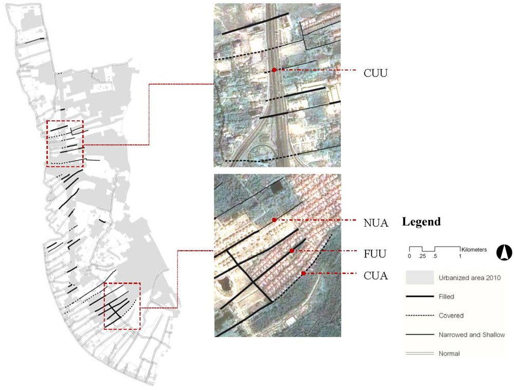
3.3. Identifying Typology of Land Configurations in Relationship to Deterioration of Private Canals

By layering the canal deterioration map, canal ownership map, land use map, and satellite image in ArcGIS, spatial configuration of land uses along both sides of deteriorated canals was investigated. This observation revealed specific land use configurations on different types of deteriorated canals. Filled canals are mostly found inside urban areas. Both sides of these canals are mostly urbanized, especially as housing estates and highways. Likewise, most covered canals are found inside urbanized areas. There are two land use configurations along covered canals, which are (1) urban land on both sides, and (2) urban land on one side and agricultural land on the other side. Most of the narrowed and shallow canals are located outside urbanized areas. However, this deterioration type is normally found on the edge between urban and non-urban lands. Therefore, one side of the canal is urban land while the other side is used for agriculture. Based on the spatial structure of private canal’s ownerships, four types of land configurations were identified which are (a) Filled-Urban-Urban (FUU), (b) Covered-Urban-Urban (CUU), (c) Covered-Urban-Agriculture (CUA), and (d) Narrowed and Shallow-Urban-Agriculture (Figure 8 and Figure 9).
Figure 8. Relationship of canal deterioration and urbanization (a) Map of canal deterioration located inside and outside urbanized area. (b) Satellite image showing different types of land configurations in relationship with canal deterioration.
Water 04 00012 g008
Figure 9. Typology of land configurations in relationship to deterioration of private canals (a) Filled-Urban-Urban; (b) Covered-Urban-Urban; (c) Covered-Urban-Agriculture;(d) Narrowed and Shallow-Urban-Agriculture.
Water 04 00012 g009

4. Discussion

The examination of the relationship between urbanization and canal deterioration revealed their correlation. A high proportion of canal filling and covering is found inside urbanized areas. This finding points out a conflict between urban and agricultural land uses, especially in the peri-urban area of BMR. As the availability of lands for development in central BMR has become very limited, demand for housing in or close to urban areas, especially for larger or cheaper ones, keeps growing. Due to the potential of its location, urbanization has taken place here in order to serve mainly as expansion of residential areas for Bangkokians. Moreover, the land cost which is much lower than that of existing urban areas attracts real estate developers to initiate housing projects in this area to take advantage of the manufacturing cost and gain higher profit [19]. When it comes to existing canals on site, not only are they considered unnecessary for housing estate projects, they are also perceived as a difficulty for sales and design which prefer a large piece of land rather than a combination of small fragmented pieces. Such inclination to consolidate land pieces originally divided by canals into a larger plot results in a tendency that canals be ignored and deteriorated by real estate developers and urbanites once housing projects are under development. Regardless, canals are still essential for farmers as channels to convey water supply to their agricultural lands. For optimal production, agricultural land requires good irrigated water in terms of both quality and quantity. Without viable canals, agricultural activities cannot continue.
The examination of the relationship between canal deterioration and public-private ownership types of canals revealed a correlation of exploitation involving private canals. It was found that most of the canal filling incidents occurred with private canals. This pattern can be explained by related laws and regulations. Based on property rights, private canals excavated on private lands are allowed to be modified or even filled by landowners. In contrast, public canals are protected by laws such as property acts, canal acts, environmental acts, civil and commercial codes and building codes. Modification or filling of these public canals are strictly not permitted. Therefore, vulnerability for deterioration of public canals is considered low especially when compared with that of private canals.
Private canals are excavated along property lines in order to bring water from main canals to orchards and paddy fields located at a further distance [10]. Accordingly, the property line which divides land ownership runs down the middle of the canal. In other words, the maintenance and manipulation of a canal are shared between the owners of the properties on both sides. Types of owners, i.e., local farmers or developers, and types of use, i.e., agricultural or urban, appear to have direct impact on canal deterioration patterns. The identification of land configurations in relationship with deteriorations of private canals reveals four types of land configurations which are (a) Filled-Urban-Urban (FUU), (b) Covered-Urban-Urban (CUU), (c) Covered-Urban-Agriculture (CUA), and (d) Narrowed and Shallow-Urban-Agriculture. This spatial structure of canal ownerships explains how each type of canal deterioration occurs as follows:

4.1. Filled-Urban-Urban (FUU)

This type of deterioration occurs when agricultural land on both sides of a canal is acquired by one or two groups of real estate developers who later develop the land for urban use. According to their legal right of land ownership, the developers have the canal in-between filled to facilitate the development project. The filled canal is thus no longer able to work as a channel to convey water to agricultural land further downstream. The problems provoke disappointment among farmers and even initiate strong conflicts between farmers and real estate developers. (Figure 9a).

4.2. Covered-Urban-Urban (CUU)

This category applies to canals in which agricultural lands on both sides have been expropriated by the government in order to build public facilities and infrastructure including highways. In order to retain the canal’s regular function as a water conveyer, pipelines are constructed in place of the canal at its original location underneath the development, i.e., the highway. However, the canal’s function for transportation is terminated. (Figure 9b).

4.3. Covered-Urban-Agriculture (CUA)

This canal deterioration type represents a case where agricultural land on one side of a canal is sold to a real estate developer while the other remains as agricultural land. In order to let the developer use the property above the private canal for development, negotiation with the farm owner across the canal is made. The deal accepted by some farmers includes a free installation of underground pipes in place of the canal. This type of canal deterioration portrays a compromise solution to avoid conflict between developers and local farmers. (Figure 9c).

4.4. Narrowed and Shallow-Urban-Agriculture (NUA)

Similar to the CUA, this category refers to canals in which land on one side is owned by real estate developers and exploited for urban uses while land on the other side is owned by farmers and traditionally used for agriculture. By claiming their ownership right, the real estate developers fill their half of the canal in order to maximize the use of their land one way or another. The partly filled canal is then narrower and shallower than its original profile. Its capability to convey water to downstream agricultural lands decreases as a consequence. This type of canal deterioration has led to conflicts between farmers and real estate developers (Figure 9d).
The deteriorations of private canals through these altered configurations were directly related to the abandonment and transformation of agricultural lands in the BMR, especially in the west area. As proved and discussed by the previous research, orchards and paddy fields supplied by private canals have been significantly more transformed than orchards and paddy fields supplied by public canals [26]. Not only do agricultural lands have principal functions for food production but they also play an important role in environmental mitigation [34]. Agricultural lands contribute to flood retention by temporarily holding up surplus water in case of heavy rain [35]. The relatively low, natural ground helps absorb and store surface water before gradually discharging it through minor and major canals to rivers and other water features. Orchards and paddy fields especially on the west bank of Chaophraya River have served as a large reservoir to collect water and protect Bangkok from flooding over the history [10]. It is therefore essential to respect flood retention function of agricultural land and integrate such an important strategy in the urban planning of flood prone areas of BMR. However, the recent flood crisis 2011 in Thailand demonstrated an extensive failure of current water management in regard to land use, urbanization and urban planning. When approximately sixteen billion cubic m of water from the north flowed downward and reached the BMR, available canals and waterways are not adequate to hold and convey water to the sea, leaving a massive amount of water on land, including urban areas. The flood crisis has caused severe damages to Bangkok and the whole country particularly in terms of economics, properties and lives, while the global supply chain has got considerable impact from a shortage of products due to heavily flooded industrial parks. Through violations and gaps in past and current urban planning, a number of industrial and housing estates now occupy former agricultural areas that otherwise would have provided fertile lands for farming and potential space for water retention. Although this flood crisis has been exceptionally severe that agricultural lands alone could not alleviate the enormous amount of run-off water and delay its flow much, the lands are still an important tool to handle normal floods which regularly occur in the BMR. Similar to agricultural lands’ flood retention capability, canals, if remaining in their optimal configurations with full capacity to convey water, would have provided higher quality water network for drainage when it comes to flooding as well.

5. Conclusions

This study confirms the significance of canal deterioration problems in the indigenous irrigation system caused by urbanization in BMR’s west peri-urban area. The findings reveal different types of canal deterioration in association with the private ownership of canals that is lacking in earlier research. Rapid urbanization over the existing indigenous irrigation system has provoked conflicts over canal networks. Canal deterioration, in which types include filled, covered, narrowed and shallow canals, essentially reduces their capability to convey the water supply to feed agricultural lands. Caused by urbanization, the deterioration of canals leads to the discontinuation of land use for agriculture and their eventual transformation for urban purposes.

Acknowledgments

The author would like to acknowledge the financial support in the form of the Higher Educational Strategic Scholarship for Frontier Research provided by the Royal Thai Government and the Scholarship for Doctoral Research provided by the University of Tokyo.
We are grateful to Mariko Miyamoto, Yosuke Watanabe, Masanori Take, Kazuhiko Nakamura, and Sato Juri, Ph.D. candidates at the University of Tokyo for their valuable comments and suggestions. We also appreciate the valuable comments and suggestions from the reviewers. We would like to thank Saithiwa Ramasoot and Ornaim Tangkitngamwong at Kasetsart University, Thailand, and Jay Bunnag for their comments and correction of the written English.

References

  1. Wittfogel, K.A. Oriental Despotism: A Comparative Study of Total Power, 6th ed; Yale University Press: New Haven, CT, USA, 1967. [Google Scholar]
  2. Groenfeldt, D. Building on tradition: Indigenous irrigation knowledge and sustainable development in Asia. Agric. Hum. Values 1991, 8, 114–120. [Google Scholar] [CrossRef]
  3. Coward, E.W., Jr. Indigenous organisation, bureaucracy and development: The case of irrigation. J. Dev. Stud. 1976, 13, 92–105. [Google Scholar] [CrossRef]
  4. Coward, E.W., Jr. Irrigation management alternatives: Themes from indigenous irrigation systems. Agric. Adm. 1977, 4, 223–237. [Google Scholar]
  5. Yokohari, M.; Takeuchi, K.; Watanabe, T.; Yokota, S. Beyond green belts and zoning: A new planning concept for the environment of Asian mega-cities. Landsc. Urban Plan. 2000, 47, 159–171. [Google Scholar]
  6. Christensen, S.R. Water allocation conflicts in Thailand: An analysis of government failure. In Water Conflicts, 2nd ed; Thailand Development Research Institute: Bangkok, Thailand, 1994; pp. 53–85. [Google Scholar]
  7. Bello, W.; Cunningham, S.; Li, K.P. A Siamese Tragedy: Development and Disintegration in Modern Thailand, 1st ed; Food First Books: Oakland, CA, USA, 1998; pp. 95–115. [Google Scholar]
  8. McGee, T.G.; Robinson, I.M. The Mega-Urban Regions of Southeast Asia, 1st ed; University of British Columbia Press: Vancouver, Canada, 1995; pp. ix–xv. [Google Scholar]
  9. Douglass, M. Global interdependence and urbanization: Planning for the Bangkok Mega-Urban Region. In The Mega-Urban Regions of Southeast Asia, 1st; McGee, T.G., Robinson, I.M., Eds.; University of British Columbia Press: Vancouver, Canada, 1995; pp. 45–77. [Google Scholar]
  10. Conover, S.A.M. The roles and contributions of the private sectors in environmental management in ASEAN Mega-Urban Regions. In The Mega-Urban Regions of Southeast Asia, 1st; McGee, T.G., Robinson, I.M., Eds.; University of British Columbia Press: Vancouver, Canada, 1995; pp. 194–214. [Google Scholar]
  11. Takaya, Y. Agricultural Development of a Tropical Delta: A Study of Chao Phraya Delta, 1st ed; University of Hawaii Press: Honolulu, HI, USA, 1987. [Google Scholar]
  12. Theerasasawat, S. History of Agricultural Technology, 1st ed; Matichon Public Co., Ltd.: Bangkok, Thailand, 2005; in Thai. [Google Scholar]
  13. Asawai, S. History of Rangsit Canal: Land Development and Social Influences Between 1888-1914, 1st ed; Thammasat University Press: Bangkok, Thailand, 1987; in Thai. [Google Scholar]
  14. Beek, S.V. The Chao Phya: River in Transition, 1st ed; Oxford University Press: Kuala Lumpur, Malaysia, 1995. [Google Scholar]
  15. Brummelhuis, H.T. King of the Waters: Homan van der Heide and the Origin of the Modern Irrigation in Siam, 1st ed; Silkworm Books: Bangkok, Thailand, 2007. [Google Scholar]
  16. Bunnag, P. Historical canals in the pas. In Canal, 1st ed; Institute of Environment, Chulalongkorn University: Bangkok, Thailand, 1994; pp. 27–57, in Thai. [Google Scholar]
  17. Sternstein, L. Portrait of Bangkok, 1st ed; Bangkok Metropolitan Administration: Bangkok, Thailand, 1982. [Google Scholar]
  18. Hincheeranan, N. Problems and obstacles in canal conservation and development in Bangkok. In Canal, 1st ed; Institute of Environment, Chulalongkorn University: Bangkok, Thailand, 1994; pp. 77–97, in Thai. [Google Scholar]
  19. Askew, M. Bangkok: Place,Practice and Representation, 1st ed; Routledge: New York, NY, USA, 2002; pp. 40-67, 86-100. [Google Scholar]
  20. Hara, Y.; Thaitakoo, D.; Takeuchi, K. Landform transformation on the urban fringe of bangkok: The need to review land-use planning processes with consideration of the flow of fill materials to developing Areas. Landsc. Urban Plan. 2008, 84, 74–91. [Google Scholar] [CrossRef]
  21. Map of Chao Phraya Delta; Pollution Control Department: Bangkok, Thailand, 2010. Available online: http://iwis.pcd.go.th/home.php (accessed on 29 September 2010).
  22. Tapvong, C. Environmental economics and management: Water pollution control in Thailand. In Counting the Costs: Economic Growth and Environmental Change in Thailand, 1st; Rigg, J., Ed.; Institute of Southeast Asian Studies: Singapore, 1995; pp. 178–195. [Google Scholar]
  23. Ross, H.; Poungsomlee, A. Environmental and social impact of urbanization in Bangkok. In Counting the Costs: Economic Growth and Environmental Change in Thailand, 1st; Rigg, J., Ed.; Institute of Southeast Asian Studies: Singapore, 1995; pp. 131–151. [Google Scholar]
  24. Mekvichai, B.; Foster, D.; Chomchan, S.; Kritiporn, P. Urbanization and Environment: Managing the Conflict; Research Report for the 1990 TDRI Year-End Conference, Chon Buri, Thailand, 8–9 December 1990; Thailand Development Research Institute: Bangkok, Thailand, 1990. [Google Scholar]
  25. Sajor, E.E.; Ongsakul, R. Mixed land use and equity in water governance in peri-urban Bangkok. Int. J. Urban Reg. Res. 2007, 31, 782–801. [Google Scholar] [CrossRef]
  26. Davivongs, V.; Yokohari, M. Canal as rural-urban conflict: Influences of canal ownerships on the urbanization process of peri-urban agricultural lands in Bangkok metropolitan region. J. Int. Symp. City Plan. 2011, 417–426. [Google Scholar]
  27. Flatters, F.; Horbulyk, T.M. Water resource conflict in Thailand: An economic perspective. In Water Conflicts, 2nd ed; Thailand Development Research Institute: Bangkok, Thailand, 1994; pp. 11–51. [Google Scholar]
  28. Kivell, P. Land and the City: Patterns and Processes of Urban Change, 1st ed; Routledge: London,UK, 1993. [Google Scholar]
  29. Map of Thailand; Central Intelligence Agency (US-CIA): Washington, DC, USA. Available online: http://en.wikipedia.org/wiki/File:Thailand_map_CIA.png (accessed on 29 September 2010).
  30. Bangraknoi Sub-district Administrative Organization, Annual Census 2010; Bangraknoi Sub-district Administrative Organization: Nonthaburi, Thailand, 2010; in Thai.
  31. Canal Map of Bangraknoi Sub-District, Nonthaburi, Thailand; Bangraknoi Sub-district Administrative Organization: Nonthaburi, Thailand, 2009.
  32. THEOS Satellite Image of Bangraknoi Sub-District, Nonthaburi, Thailand; Geo-Informatics and Space Technology Development Agency (GISTDA): Nonthaburi, Thailand, 2010.
  33. GIS Data Cadastral Map of Nonthaburi Province, Thailand. Nonthaburi Provincial Administrative Organization: Nonthaburi, Thailand, 2010.
  34. Nugent, R.A. Measuring the sustainability of urban agriculture. In For Hunger-Proof Cities: Sustainable Urban Food System, 1st; Koc, M., MacRae, R., Mougeot, L.J.A., Welsh, J., Eds.; International Development Research Centre: Ottawa, Canada, 1999; pp. 95–102. [Google Scholar]
  35. Yoshida, K. An Economic Evaluation of the Multifunctional Roles of Agriculture and Rural Areas in Japan; Technical Bulletin Issue 154; Asia and Pacific Council, Food and Fertilizer Technology Center: Taipei, Taiwan ROC, 2011; pp. 1–9. [Google Scholar]

