1. Introduction
The water-energy-food nexus (“the nexus”) and its different variations (including, e.g., security [
1], climate change [
2] or ecosystems [
3]) are discussed by a variety of actors [
4,
5,
6,
7,
8,
9,
10,
11,
12,
13,
14,
15,
16,
17]. “Nexus” literally means “a means of connection between things in a series” [
18], and the water-energy-food nexus focuses on the linkages between the three nexus themes. The main rationale for those promoting the water-energy-food nexus is that as the different nexus themes are so closely related, they should be looked at simultaneously to encourage win-win situations, avoid negative impacts and, ultimately, enhance sustainability. As Hoff (2011) [
1] puts it: “
The nexus focus is on system efficiency, rather than on the productivity of isolated sectors”.
Such objectives are by no means completely new, but share similarities with the aims of integrated approaches such as Integrated Water Resources Management (IWRM) [
19,
20]. They are, however, perhaps more important than ever given the growing scarcity of land, water and related resources caused by population growth and increasing demand for food and energy. When discussing the nexus, it is useful to recognise that it has different dimensions: we discuss what we consider to be the two key dimensions of the nexus. The first dimension promotes the nexus as an approach for research and analysis by, for example, quantifying the linkages between the nexus sectors [
1,
6,
21,
22,
23]. The second dimension presents the nexus more as a policy-making tool that is seen to facilitate cross-sectoral collaboration and integrated planning and policy-making [
3,
4,
9,
24]. The key in both is to focus on the linkages between the nexus themes, rather than on separate themes and sectors alone.
This article looks at the water-energy-food nexus in Cambodia’s Tonle Sap Lake area. Tonle Sap Lake is closely connected to the transboundary Mekong River, and the annual floods of the Mekong are the main driving force for the Tonle Sap flood pulse. The flood pulse extends the lake to the vast floodplains, and brings fertile suspended solids and fish larvae to the lake-floodplain system. For the same reason, the hydrological and environmental changes happening in the Mekong River Basin have direct impacts to the Tonle Sap system [
25,
26,
27]. As a result, while the Tonle Sap system forms an important source of local and national food security, its food production capacity is threatened by one of the most intensive hydropower development plans in the world [
28]. The area thus presents a highly topical example of a transboundary water-energy-food nexus context, but the area and its future development has not yet been assessed using such an approach.
This article aims to fill this research gap by presenting the key findings from a research project focusing on the Tonle Sap Lake [
29]. The project was active in 2010–2013 and had the water-energy-food nexus as its starting point [
30], seeking to increase the understanding of the Tonle Sap system in terms of water, energy and food security as well as climate change. While the project built on the earlier research by the authors in the area [
31,
32,
33,
34,
35], the nexus approach was expected to provide new insights as well as to facilitate science-policy-stakeholder interaction. Both were seen to be important given the significance of the Tonle Sap system, the changes it is experiencing and the management challenges of the area [
36]. The analysis made use of new information and novel research methods, including detailed, cumulative assessment of the impacts of hydropower development and climate change on the Tonle Sap as well as the first-ever trend analysis of key demographic and socio-economic indicators using the Population Census for years 1998 and 2008. Special attention was paid to the policy relevance of the research results, and the project was done in close collaboration with the governmental Tonle Sap Authority (TSA).
In this article, we discuss the key findings from our research project in both practical terms (the Tonle Sap system and its future, with emphasis on the nexus) and in methodological terms (the role that nexus had in our study; also when compared to our earlier experiences using IWRM). The aim of the article is thus two-fold: To increase understanding of the Tonle Sap system and to contribute to the on-going discussion about the nexus as an approach.
2. Materials and Methods
2.1. Defining the Linkages between the Nexus Themes
The nexus approach selected for this study put the emphasis on the interconnections between water, energy and food security. Due to the unique character of the Tonle Sap system, the roles that water, energy and food have in our study as well as the ways they are linked were relatively different from each other. Energy security was considered largely through hydropower development, with such development taking place in the upstream parts of the Mekong River Basin and in Laos in particular [
37]. Together, energy and climate change were seen mainly as external transboundary drivers that have impacts on the Tonle Sap system. The local-scale analysis in the Tonle Sap area focused then on the possible changes in water resources and food security as well as on the recent trends in demography and livelihoods. The research on these themes was carried out under two research components focusing on: (1) hydrology and water resources and (2) livelihoods and food security.
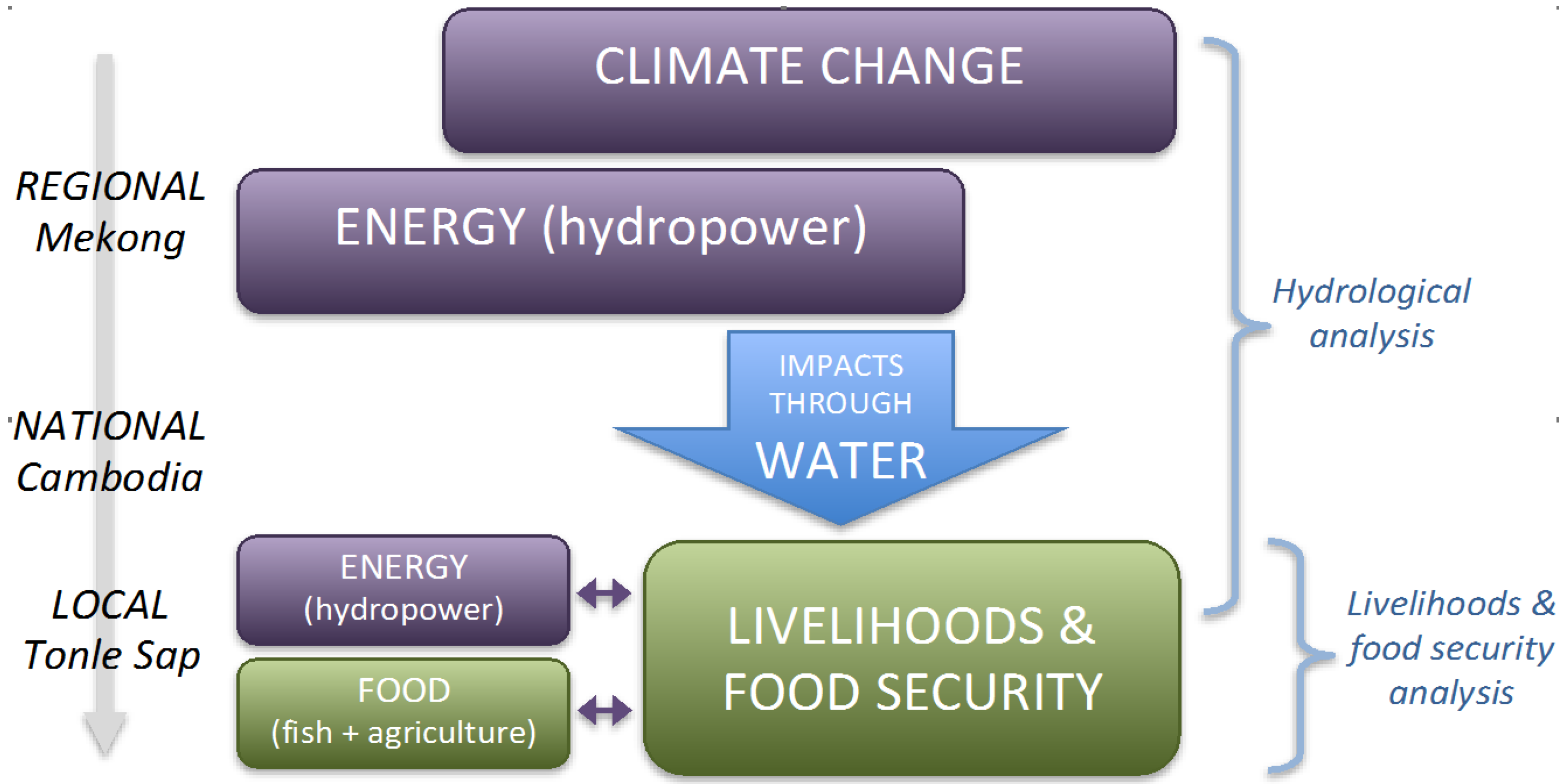
The key linkages between the nexus themes are expressed as a flow chart in
Figure 1, with water acting as the connecting factor between energy and food security as well as climate change across the three geographical scales. The approach was selected in July 2010, before most of the key water-energy-food nexus publications, and it therefore differs from depictions of the common nexus approach, where the connections between water, energy, and food security are usually described in equal terms and visualised with a triangle [
1,
5,
9].
Figure 1.
The key connections between the nexus themes of water, energy and food security as well as climate change, together with three geographical scales (left) and two research components (right).
Figure 1.
The key connections between the nexus themes of water, energy and food security as well as climate change, together with three geographical scales (left) and two research components (right).
2.2. Research Component on Hydrology and Water Resources
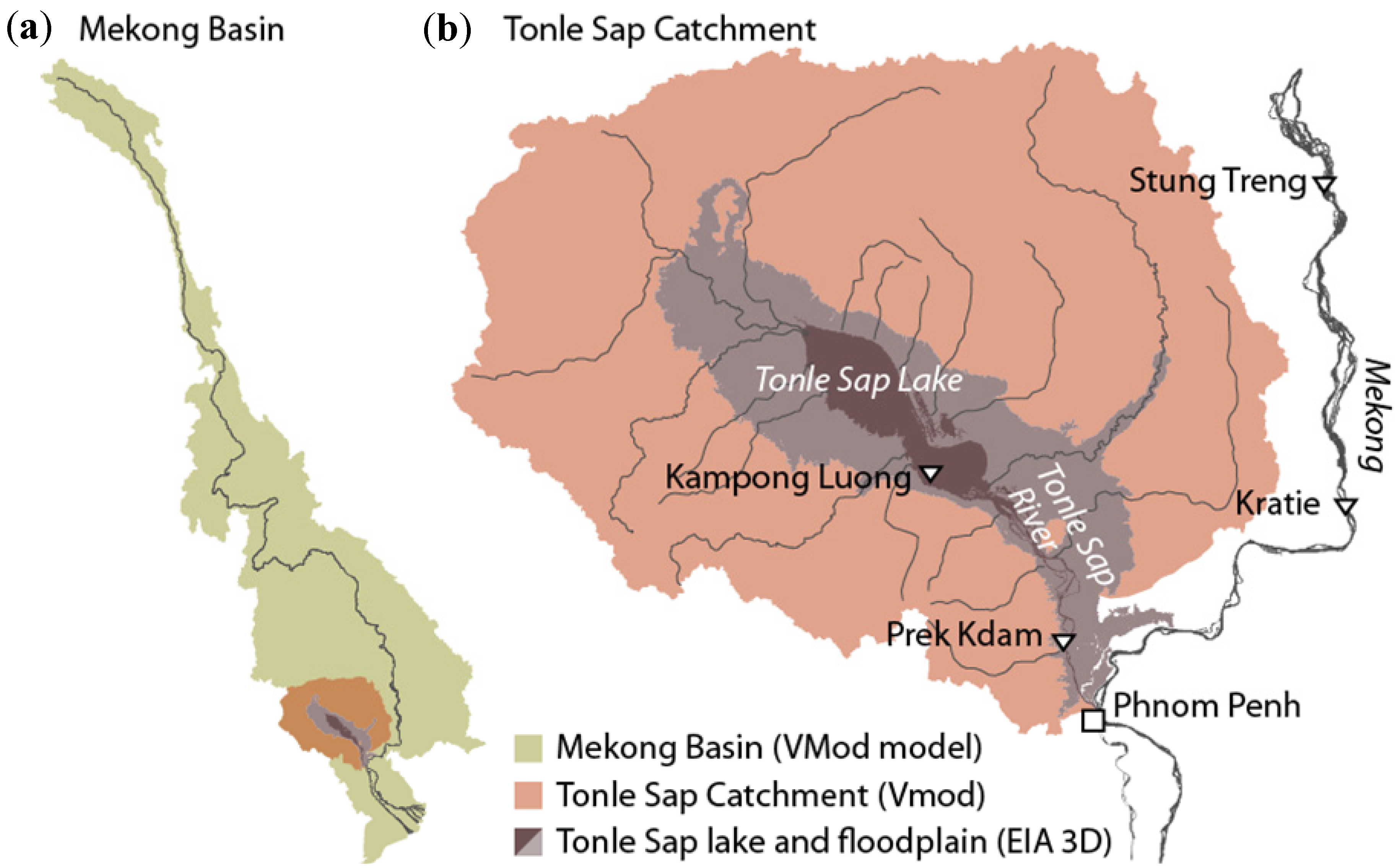
The first research component created the link from energy (
i.e., Mekong hydropower development) and climate to water resources by analysing the impacts of regional level changes to the Tonle Sap’s flow regime (
Figure 2) [
38]. The impacts from the Mekong hydropower development and climate change were analysed both separately and together, using the ten-year period from 2032 to 2042.
The analysis under this research component was done with the help of two mathematical models. A distributed hydrological model called VMod [
39] was established for the whole Mekong River Basin. The VMod hydrological model is a dynamic model constructed from square grid cells, and it was used to simulate the cumulative impacts of hydropower development and climate change on the Mekong flow regime. A 5 km × 5 km resolution raster dataset was constructed for the VMod model using SRTM 90 m elevations [
40], Global Land Cover 2000 [
41], and the Food and Agriculture Organisation of the United Nations (FAO) soil map of the world [
42]. The main meteorological and discharge data were acquired from the Mekong River Commission (MRC) database [
43].
After the model grid and the data were set up, the VMod model was calibrated against measured discharge for the calibration period (1982–1991). The validity of the model calibration was checked by computing the validation period (1993–1999) using the calibrated parameters, and comparing the fit from the validation period to calibration period results in selected river stations. The modelled daily discharge over the validation period agreed very well with the measured ones: Nash-Sutcliffe efficiency (NSE) varied from 0.78 to 0.94, depending on the station [
38]. The relationship is shown visually in
Figure S1 in the supplementary material.
Figure 2.
The three geographical scales of hydrological analysis and the related drivers of change: (a) Mekong River Basin, (b) Tonle Sap Lake catchment as well as the lake and its floodplain. The model used at each scale is indicated in parentheses.
Figure 2.
The three geographical scales of hydrological analysis and the related drivers of change: (a) Mekong River Basin, (b) Tonle Sap Lake catchment as well as the lake and its floodplain. The model used at each scale is indicated in parentheses.
The VMod model was then linked to a more detailed EIA 3D floodplain model [
38] that simulated the impacts of basin-wide cumulative changes on the Tonle Sap flood pulse. The EIA 3D model is a three-dimensional baroclinic multilayer model that numerically solves the simplified Navier-Stokes equations using the implicit finite difference method [
44]. Incoming flow at Kratie and from the Tonle Sap Catchment based on simulations from [
38] and water levels at the South China Sea near the Mekong Delta based on [
45] were used as upstream and downstream boundary conditions, respectively. The EIA 3D floodplain model was calibrated against measured water levels. As shown in
Figures S2−S3 of the supplementary material, the model is able to regenerate the measured flood pulse rather well.
The regional climate change scenarios for the hydrological model were obtained by downscaling five different Global Circulation Models (GCMs) for the Mekong Basin. For the selected GCMs, two different emission scenarios, i.e., B1 (550 ppm stabilisation) and A1b (720 ppm stabilisation), were used. The MRC hydropower database was used to account for future development of large-scale hydropower in the Mekong Basin. To define the operation of hydropower reservoirs, a linear programming optimisation was used with the monthly outflows for each reservoir estimated separately, starting upstream.
2.3. Research Component on Livelihoods and Food Security
The second research component looked at local water and food security through analysis of the demographic and socio-economic situation and its trends in the Tonle Sap area. The analysis built on extensive spatial analysis of the key socio-economic databases,
i.e., Population Census 1998 and 2008 [
46], and it was complemented by the CSIRO Tonle Sap Household Survey covering 1000 households in the area [
47]. Due to Cambodia’s tumultuous history [
48], the Population Censuses of 1998 and 2008 are the first demographic datasets since 1960s, providing a major opportunity to look at the key demographic and socio-economic trends in the country. There have been very few analyses done on such trends anywhere in Cambodia, e.g., [
49], and none in the specific context of the Tonle Sap Lake.
The Census data includes vast number of indicators, and for our analysis we selected demographic and socio-economic indicators that are particularly relevant for livelihoods, well-being and overall development. Given the close connection between the lake and the livelihoods of the area, many indicators have also a strong link to water and food security. The analysis looked both the current status (as of 2008) and the recent trends (from 1998 to 2008) of these key indicators. The change from 1998 to 2008 was looked in two ways: in terms of quantities (e.g., number of people having fishing as their main source of livelihood) and in terms of proportion (e.g., percentage of economically active population engaged in fishing).
The selected indicators were grouped and analysed spatially, with the Tonle Sap area divided into three spatial zones: Zone 1 (Lower Floodplain), Zone 2 (Upper Floodplain), and Zone 3 (Urban) (see also [
32]). Such a spatial approach was used to establish a connection with the hydrological analysis and the lake itself. To provide a link with policy-making, the spatial zones were further divided into 18 sub-zones based on the administrative boundaries of the six Tonle Sap provinces. The statistical meaningfulness of the spatial zones was tested with k-means clustering of the Population Census data; the test confirmed that the Census data can be organised with spatially interpretable linkages to water and main livelihood sources [
46].
The analysis of local water and food security was complemented by mapping of local water infrastructure in the Tonle Sap area. This mapping exercise focused on food security and energy security, and included major irrigation structures and hydropower development in the Tonle Sap Basin collected from a variety of information sources. While such infrastructure is a major component of local water, energy and food security, this was first time that location-specific information on such infrastructure was publicly presented in a single map [
50].
2.4. Scenario Formulation: Four Alternative Futures for the Tonle Sap
The two research components were supported by a scenario process that was used to describe and discuss the connections between water, energy, food and climate change. The scenarios thus created a kind of synthesising nexus framework for the study, connecting two research components that looked only at selected nexus themes. The aim of the scenario process was to create plausible alternative futures for the Tonle Sap in year 2040, taking into account both external and internal drivers affecting the area.
The scenario process included three phases and was built on a set of stakeholder workshops with the participation of a number of experts on different nexus themes. The process was initiated by the creation of alternative scenario narratives for the Tonle Sap during the first two stakeholder workshops [
51,
52]. These scenario narratives helped to focus the actual research, with initial research results being discussed in the following two stakeholder workshops. The research findings were synthesised and connected to policy-making through the creation of four alternative scenarios for the Tonle Sap in 2040 that were elaborated during the last workshop.
This also means that our final scenarios can be seen to be close to data- and analysis-driven forecasts that build on our modelling estimates and socio-economic trend analyses. While there are also other, less rigid ways to create scenarios [
53,
54,
55], the main characteristics of our scenarios are in line with the general scenario description by the Intergovernmental Panel on Climate Change (IPCC): “
A scenario is a coherent, internally consistent and plausible description of a possible future state of the world. It is not a forecast; rather, each scenario is one alternative image of how the future can unfold” [
56].
3. Key Results: Water-, Energy-, Food- and Climate-Related Drivers in the Tonle Sap
This section presents the key results from the two research components (
Figure 1) as well as from the scenario formulation process. The results are based on Keskinen
et al. [
29], with emphasis on their implications for the water-energy-food nexus. For more detailed description of the results, see [
29,
38,
46].
3.1. Hydrological Analysis of Energy- and Climate-Related Drivers
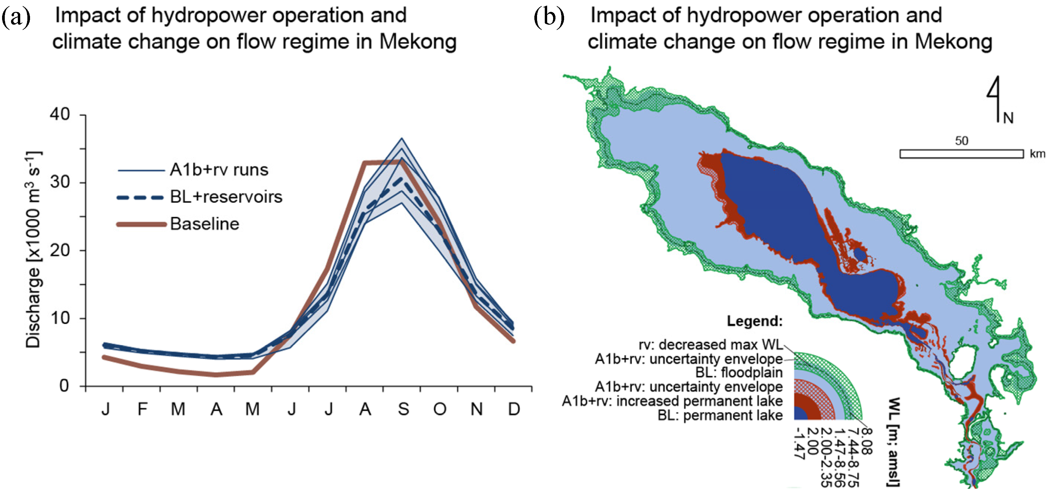
The hydrological research component analysed how energy- and climate-related drivers impact the Tonle Sap system’s hydrology and, consequently, food security. The modelling results clearly indicate that the flood pulse of the Tonle Sap is likely to change in the future, with the planned hydropower dam development in the Mekong River Basin causing dramatic changes to the flood dynamics and hydrology. The operation of planned hydropower dams will flatten the hydrograph by causing higher dry season water levels and lower flood peaks (
Figure 3).
The analysis shows that climate change will cause changes to the rainfall and temperature in the area, impacting the runoff and water levels in the Mekong mainstream and in the Tonle Sap system. However, our analysis indicates that the exact impact of climate change remains unclear, mainly due to differences in the different GCMs applied to the Mekong Basin. Remarkably, even the direction of the flow changes caused by climate change differs depending on the emission scenario and GCM used. Consequently, it is impossible to even say whether climate change will increase or decrease the flood season water level in the Tonle Sap.
Within the timeframe used in the model, i.e., by the year 2042, climate change alone does not have a considerable impact on the dry season water level in the lake. The climate change impact on the flooded area, which is an important element for ecosystem productivity, is thus uncertain, with the estimates for the future floodplain area varying from 92% (8832 km2) to 109% (10,464 km2) of the current average floodplain area of 9600 km2.
In contrast, the cumulative impacts of hydropower operation and climate change have a clear impact on dry season water levels, which are estimated to be 0.5–0.9 m above the current levels. This would mean that the permanent lake area would increase 18%–31%, submerging important habitats, such as flooded forest (
Figure 3). The cumulative impacts are also significant for the flood season water levels, with our modelling estimates indicating lower flood peaks, although with large uncertainty due to the differences in GCMs used in the study. Overall, the floodplain area is expected to significantly reduce due to cumulative impacts from climate change and hydropower reservoirs, with the minimum area being around 75% of the current floodplain area.
Figure 3.
Estimated future changes to discharge and water levels. (
a) Impact of reservoir operation (rv) and climate change (A1b scenario) on flow regime in the Mekong mainstream in Kratie, Cambodia (see location in
Figure 2); figure modified from [
38]; (
b) Map of the estimated future changes (2032–2042) caused by the cumulative impacts of climate change (A1b) and reservoir operation (rv) in the permanent lake and flooded areas compared to the baseline (BL; 1982−1992).
3.2. Livelihood & Food Security Analysis
The livelihood and food security analysis looked at the current demographic and socio-economic situation and trends in the Tonle Sap area and related them to food security by focusing on agriculture and fishing as main livelihood sources. The three zones (Lower floodplain, Upper floodplain and Urban areas) created differ greatly in terms of their population, area as well as relationships to the lake and its flood pulse. While Zone 2 clearly has the biggest population, Zone 1 is the largest area-wise and is most directly connected to the lake and its flood pulse due to its location.
Altogether, the Tonle Sap study area has some 1,707,000 people (according to Population Census 2008) living in 1555 villages and settlements, with 1244 of those being rural and 311 urban. The very clear dominance of youth in the total population is demographically remarkable: the two biggest age groups are between 15–19 years and 20–24 years. These young people are thus just entering the work force, searching for meaningful work opportunities.
People living in and around the Tonle Sap Lake have adapted to the enormous annual variation of the lake’s water level; many even live in floating houses on the lake itself. People’s livelihoods are closely connected to the lake and the natural resources it provides and supports. From the nexus point of view, the strong connection between livelihoods and food security is remarkable: Agriculture clearly dominates (61% of total work force has it as main livelihood), with fishing coming third (4.5%) after trade (11.5%) (
Table 1). Over 65% of the Tonle Sap’s work force thus has either agriculture or fishing as their main livelihood source, and both sectors form significant secondary livelihood sources as well. In addition, agriculture and fishing are the most important contributors to national food security, with rice and fish being the staple food of Cambodia.
Our findings indicate that the total work force in the agricultural and fishing sector increased dramatically between 1998 and 2008 due to rapid population growth. Although the proportion of the workforce engaged in the agricultural sector decreased slightly from 66% in 1998 to 61% in 2008, the number of people workforce in the sector increased by 130,000 people. A similar finding was evident in the fishing sector, where the absolute number of people with fishing as their main economic activity increased by 10,700 people, although the proportion of people involved in the sector decreased from 4.7% in 1998 to 4.5% in 2008 (
Figure 4). Hence, over 140,000 new people established agriculture and fishing as their main economic activity between 1998 and 2008. Such an increase obviously puts pressure on existing resource use but may also enhance food security if it leads to increased and more diverse food production.
At the same time, it is important to note that there are remarkable differences between the livelihood structures in different zones and sub-zones of the Tonle Sap (
Table 1). While fishing is the most important livelihood activity in the areas closest to the lake, urban areas in particular have much more diverse livelihood structures. In addition, there are considerable differences across the six Tonle Sap provinces. The comparison between Population Census 2000 and 2008 also show that the general livelihood structure is slowly diversifying, with an increasing number of people gradually transferring from traditional, agriculture-based livelihoods to other sources of livelihood. This is particularly visible in the urban areas, with the provincial capitals and Siem Reap in particular also attracting migrants from the rural areas.
Table 1.
Involvement in key livelihood sectors by 3 zones and 18 sub-zones. Data source: [
57].
Table 1.
Involvement in key livelihood sectors by 3 zones and 18 sub-zones. Data source: [57].
| Zones | Agriculture (Include Forestry) | Fishing | Wholesale | Construction | Transport, Storage and Communication | Manu-Facturing | Total for Six Sectors |
|---|
| % | Number of People | % | Number of People | % | Number of People | % | Number of People | % | Number of People | % | Number of People | % | Number of People |
|---|
| Zone 1: Lower Floodplain | 28.3 | 12,589 | 60.2 | 26,801 | 6.7 | 2998 | 0.2 | 103 | 1.3 | 568 | 0.9 | 408 | 97.6 | 43,467 |
| Banteay Meanchey | 97.4 | 1,190 | 0.4 | 5 | 0.3 | 4 | 0.0 | 0 | 0.0 | 0 | 0.2 | 2 | 98.3 | 1,201 |
| Battambang | 2.4 | 145 | 85.6 | 5,253 | 7.7 | 472 | 0.4 | 24 | 0.8 | 51 | 0.6 | 34 | 97.4 | 5,979 |
| Kampong Chhnang | 43.7 | 5,212 | 43.2 | 5,161 | 7.3 | 873 | 0.4 | 43 | 2.2 | 267 | 0.8 | 90 | 97.6 | 11,646 |
| Kampong Thom | 17.3 | 887 | 76.8 | 3,935 | 3.8 | 195 | 0.0 | 0 | 0.0 | 2 | 0.3 | 15 | 98.3 | 5,034 |
| Pursat | 21.4 | 1,756 | 67.5 | 5,533 | 7.1 | 579 | 0.1 | 5 | 1.1 | 92 | 1.1 | 90 | 98.3 | 8,055 |
| Siem Riep | 28.5 | 3,399 | 58.1 | 6,914 | 7.3 | 875 | 0.3 | 31 | 1.3 | 156 | 1.5 | 177 | 97.0 | 11,552 |
| Zone 2: Upper Floodplain | 80.9 | 433,777 | 1.3 | 6898 | 5.6 | 30,253 | 2.5 | 13,246 | 1.5 | 8095 | 2.1 | 11,253 | 93.9 | 503,522 |
| Banteay Meanchey | 81.9 | 58,794 | 0.5 | 374 | 4.6 | 3,323 | 2.0 | 1,449 | 1.7 | 1,212 | 2.7 | 1,912 | 93.4 | 67,064 |
| Battambang | 76.6 | 90,193 | 1.5 | 1,789 | 7.2 | 8,422 | 3.4 | 4,043 | 2.2 | 2,594 | 2.4 | 2,845 | 93.3 | 109,886 |
| Kampong Chhnang | 81.3 | 35,404 | 2.2 | 956 | 4.9 | 2,114 | 1.1 | 464 | 1.1 | 478 | 3.1 | 1,341 | 93.6 | 40,757 |
| Kampong Thom | 85.7 | 59,329 | 1.2 | 834 | 4.5 | 3,104 | 1.0 | 660 | 1.3 | 896 | 1.7 | 1,159 | 95.3 | 65,982 |
| Pursat | 84.8 | 79,451 | 1.4 | 1,278 | 5.0 | 4,646 | 1.0 | 951 | 1.1 | 1,053 | 1.1 | 1,049 | 94.4 | 88,428 |
| Siem Riep | 79.0 | 110,606 | 1.2 | 1,667 | 6.2 | 8,644 | 4.1 | 5,679 | 1.3 | 1,862 | 2.1 | 2,947 | 93.9 | 131,405 |
| Zone 3: Urban | 27.6 | 74,411 | 1.7 | 4549 | 24.0 | 64,677 | 6.8 | 18,275 | 7.8 | 21,043 | 6.3 | 16,917 | 74.1 | 199,872 |
| Banteay Meanchey | 32.9 | 12,667 | 0.6 | 213 | 27.0 | 10,391 | 6.9 | 2,658 | 7.6 | 2,910 | 6.6 | 2,540 | 81.6 | 31,379 |
| Battambang | 30.3 | 24,180 | 0.7 | 530 | 24.1 | 19,256 | 6.5 | 5,217 | 7.5 | 6,008 | 7.6 | 6,046 | 76.6 | 61,237 |
| Kampong Chhnang | 18.3 | 3,644 | 12.0 | 2,381 | 27.7 | 5,502 | 4.0 | 804 | 7.9 | 1,562 | 9.5 | 1,897 | 79.5 | 15,790 |
| Kampong Thom | 53.6 | 13,701 | 0.7 | 177 | 15.7 | 4,014 | 2.6 | 661 | 4.5 | 1,156 | 3.7 | 944 | 80.8 | 20,653 |
| Pursat | 38.4 | 7,547 | 0.3 | 57 | 20.3 | 3,995 | 4.8 | 940 | 5.5 | 1,084 | 4.6 | 897 | 73.9 | 14,520 |
| Siem Riep | 53.2 | 126,677 | 4.1 | 9,772 | 13.0 | 31,038 | 5.8 | 13,705 | 4.3 | 10,341 | 3.2 | 7,726 | 83.7 | 199,259 |
| Total for Tonle Sap | 61.3 | 520,777 | 4.5 | 38,248 | 11.5 | 97,928 | 3.7 | 31,624 | 3.5 | 29,706 | 3.4 | 28,578 | 87.8 | 746,861 |
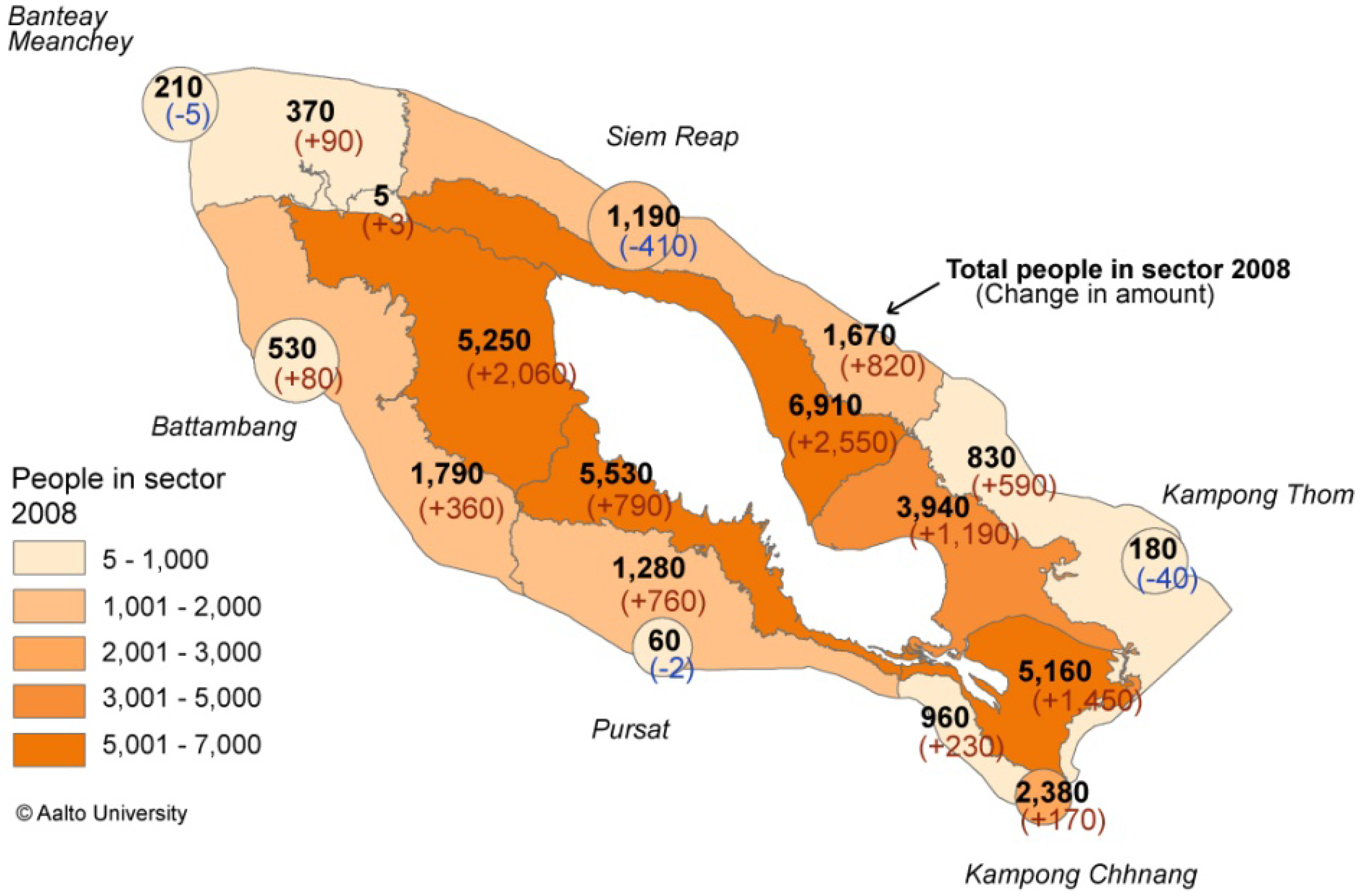
Figure 4.
The map of Tonle Sap area and its zoning, with six sub-zones of Lower Floodplain closest to the lake, Upper Floodplain further and Urban areas indicated as six circles around provincial capitals. The numbers indicate the number of people with fishing as their main source of livelihood. Bold figures indicate the total number in 2008, while the figures in parentheses show the change from year 1998 based on comparison between Population Census 1998 and 2008. Blue numbers indicate decline and red increase in the number of people. Reproduced with permission from Aalto University, 2013 [
29].
3.3. Alternative Scenarios for the Tonle Sap in 2040
The two research components described above provided new information about energy-, climate-, water- and food-related trends and pressures in the Tonle Sap area. To help understand future development from a nexus approach, these were integrated using a scenario formulation process that made use of the results from both research components. A scenario process was selected because it did not seem reasonable to create just one possible view about the ways the water, energy and food security are likely to develop in the future. Instead, the research findings were synthesised by creating four alternative scenarios for the Tonle Sap in 2040.
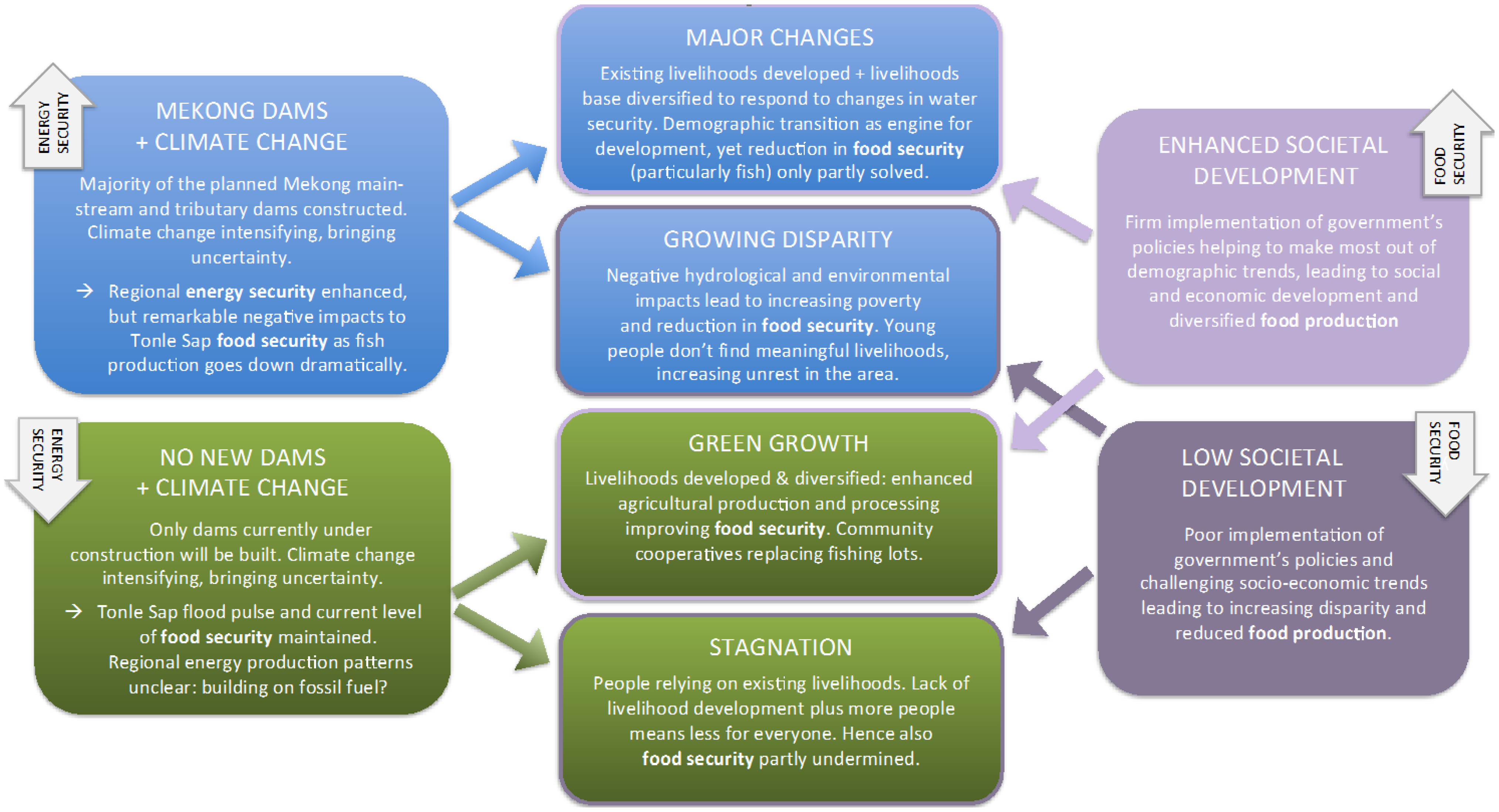
The starting point for the scenario formulation was energy-related, namely the decision whether or not to build more mainstream and tributary dams in the Mekong River Basin. This created two alternative “water and energy paths” for the scenario process: One with many Mekong dams (blue path) and one with only currently existing or under construction dams (green path). Next, the possible differences in the livelihood development and the implementation of government’s policies [
58] led to two different kinds of “societal development paths”. Together, these two paths produced four alternative scenarios for the Tonle Sap by 2040: Major changes, Growing disparity, Green growth, and Stagnation (
Figure 5).
Figure 5.
Four alternative scenarios created for the Tonle Sap in 2040 (centre), with two alternative water and energy paths on the left and two alternative societal development paths on the right. Grey arrows indicate how energy security and food security are likely to develop as part of different paths.
All four alternative scenarios present different but nevertheless plausible futures for the Tonle Sap area. Importantly, they also have differing implications across the water-energy-food nexus at different scales (
Figure 1). While the paths related to hydropower construction will impact energy security at regional scale, they also have direct implications for local water and food security. At the same time, the scenarios indicate that the future of the Tonle Sap depends very much on how socio-economic situation and livelihoods develop as a response to these external changes.
4. Discussion
In this article, our focus is two-fold. In practical terms, we assess water, energy, food and climate-related drivers in the Tonle Sap area. In methodological terms, we discuss the implications that using the water-energy-food nexus approach had in our study. The article provides a novel analysis of how the combination of external drivers (regional hydropower development and climate change) and internal drivers (demographic and socio-economic trends) is likely to affect the area’s long-term development (four alternative futures). At a more theoretical level, the study provides an opportunity to discuss the pros and cons of a nexus approach in terms of both research and science-policy-stakeholder interaction, also making use of the authors’ previous research experience in the area. Next, we will discuss both these aspects in more detail, together with the consideration of key limitations of our study.
4.1. Implications for the Tonle Sap Area: National Food Security in Danger
The Tonle Sap Lake area forms a critically important economic, social and environmental resource for the whole of Cambodia, yet is under threat from the possible changes that regional hydropower development will cause for its flood pulse. The possible changes in the flood pulse are expected to radically reduce the ecosystem productivity of the lake-floodplain system, leading also to remarkable social and economic impacts. Based on our analysis, we foresee that the most remarkable impacts are related to three, interlinked changes.
Firstly, the expected shifts in floodplain habitats [
59] due to a changed flood regime can potentially be very destructive for existing floodplain ecosystems, also negatively impacting aquatic production. On the other hand, they can also lead to modest increases in agricultural areas in the upper floodplain, thus enabling potential increases in agricultural production. Secondly, increased dry season water levels are expected to lead to the destruction of the majority of the flooded forests surrounding the lake, having a notable impact on sedimentation processes, ecosystems and aquatic productivity. It would also impact environmental conservation and, hence, ecotourism, as large parts of the current conservation core areas would be permanently submerged.
Thirdly and most importantly, the hydrological and environmental changes put major pressure on the Tonle Sap’s immense fish production. While the connection between Tonle Sap’s primary production and fish production is still not very well understood [
60,
61], it is expected that the changes described in our results would lead to remarkable reductions in fish production. Such a radical reduction would naturally have negative implications for livelihoods in the Tonle Sap area, with people in the lower floodplain most affected. It would also have broader implications due to the critical importance of fish for food security: up to 80% of all animal protein consumption in Cambodia comes from fish and other aquatic animals [
62], and Cambodian fisheries contribute considerably to regional food security thanks to fish migration and fish export [
63,
64]. Mitigating the impacts of reduced fish production on food security would require significant improvements in current food production, but this is challenging due to the limited amount of water and land available [
65]. Consequently, the reduced fish production will lead to decreased self-sufficiency, increasing dependency on food imports and, ultimately, reduced food security.
In addition to these environmental pressures, the Tonle Sap area is seeing major demographic and socio-economic changes. Our analysis shows that almost 2 million people already live in the lake and its floodplains, with exceptionally large numbers of young people entering the work force, changing the livelihood dynamics. Given the dominance of agriculture, and the combination of management challenges and already heavy pressure on the area’s natural resources, the Tonle Sap’s future depends very much on what kinds of livelihood sources these young people are able to move to.
As illustrated by the four alternative futures (
Figure 5), the future of the Tonle Sap area thus depends on both external drivers and internal changes in the demographic and socio-economic setting of the area. This puts pressure on the key actors, including the Cambodian government. In sum, we see that the Cambodian government and its line agencies should take simultaneous action at three levels. Regionally, the Cambodian government needs to engage into active dialogue with its upstream neighbours about the most sustainable ways to develop the Mekong River Basin to minimise the impacts on the Tonle Sap system. While the Mekong River Commission (MRC) provides the most obvious arena for such a dialogue, its inherent political challenges [
66,
67] mean that Cambodia needs to support the regional processes with proactive bilateral negotiations.
At a national level, firm implementation of the Cambodian government’s development plans is the key for the Tonle Sap. On the positive side, Cambodia’s Rectangular Strategy [
58] already incorporates practically all relevant policies that are needed for the positive livelihood transformations to occur in the Tonle Sap within next decades. Yet implementing these ambitious plans requires close collaboration between the different ministries, active stakeholder participation, and, generally, good governance; all of these have traditionally been in rather short supply in Cambodia [
68]. Finally, at a local level, the dominance of traditional livelihood sources and relatively slow livelihood transformations suggest that any livelihood development in the Tonle Sap area should use the existing livelihood structure as a foundation, and entirely new livelihood sources should be seen as complementary to this.
4.2. Methodological Implications: the Role of the Water-Energy-Food Nexus Approach
In terms of research, the nexus approach used in our study encouraged simultaneous use of several research methods, for the analysis of the interlinkages between the nexus themes cannot be done with one method alone. The nexus approach was also useful in highlighting the differing scales of the nexus themes; while the analysis focused on the local scale (the Tonle Sap), food security was examined at national scale, and energy security and climate change at regional scale as well.
However, our previous research activities in the Tonle Sap have already utilised similar kinds of approaches as well [
31,
34], their use being encouraged by Integrated Water Resources Management (IWRM), which is widely used in the Mekong [
7,
69] and shares many similarities with the nexus [
70,
71]. The nexus and IWRM can therefore be seen to encourage comparable analytical approaches, which are explicitly integrated, cross-sectoral and cross-scale. Compared to IWRM, we consider that the most important contribution of the nexus approach for our research was that it encouraged us to focus our attention on the linkages between water, energy, food and climate, which we achieved through the use of scenarios. The scenarios combined water, energy and food-related drivers, providing a synthesising framework for the entire study. The scenario formulation process brought two other notable benefits for our study. Firstly, it enabled the inclusion of the stakeholders’ views from the very beginning, providing guidance and early feedback to our research. Secondly, it allowed the creation of alternative scenarios that facilitated discussion about the uncertainties related to our research results and also made the critical role of policy choices visible.
In terms of integrated planning and cross-sectoral collaboration, interesting findings emerge. When compared to our earlier research projects (that had a more explicit focus on water resources management), the simple fact that the nexus approach explicitly spelt out the key sectors and themes ensured more diverse engagement of stakeholders into the project workshops. The nexus thus enhanced cross-sectoral stakeholder dialogue by expanding the discussion from mere water resource management to the broader aspects of water, energy and food security; this link to cross-sectoral collaboration has been noted also by other authors [
10,
72,
73]. In addition, the explicit focus on these themes created a common ground for stakeholders with different backgrounds. In this way, the nexus appeared as a kind of boundary object: the nexus as a concept is robust enough to establish a commonly agreed platform for discussion, yet flexible enough to allow different interpretations by various actors based on their differing views and interests [
71,
74,
75]. This also opens up possibilities for new kinds of coalitions in transboundary contexts, alleviating dominant upstream-downstream tensions. For example, cross-country coalitions between energy ministries or fisheries authorities may help to counter riparian countries’ often rather monolithic positions.
4.3. Limitations and Way Forward
Our study used a nexus approach to look at water, energy and food security in the Tonle Sap Lake. As the study was initiated already in July 2010, our approach was somewhat different when compared to other nexus approaches introduced later [
1,
6,
10]. This meant that the majority of the actual research was done through two separate research components that focused only on one or two nexus themes, with the linkages between all of them being then considered only during the scenario formulation process. Also, while the nexus approach used did encourage the use of scenarios, scenarios are obviously not specific only to the nexus but could also be used with other approaches. In addition, the alternative scenarios created were methodologically quite close to conventional data-based forecasts, although building on the broader ideas of scenario formulation [
53].
It must also be noted that in order to maintain the focus, we looked only at selected water-, energy and food-related themes and drivers. Such focus left out other important (and nexus-relevant) themes, including for example the possible flow impacts caused by regional irrigation development and land use changes. This highlights an important aspect of the water-energy-food nexus; given its broadness, it is practically unavoidable to leave out some less important but still relevant aspects from the nexus analysis. Such a finding relates to the conclusion by Guillaume
et al. [
14], who note that subsystems included and excluded from the nexus are case-specific and should be consciously scrutinised.
The research component focusing on livelihoods and food security relied heavily on the quantitative data available from Population Census 1998 and 2008. While ensuring very good coverage (the data includes every household and village in the Tonle Sap area), the datasets also have their limitations. Perhaps most importantly, the two Censuses recorded only main economic activity, meaning that the seasonal variation and general diversity of livelihood sources in the Tonle Sap were not properly captured [
46]. This is likely to be particularly critical for fishing and related activities, which also form important secondary and tertiary livelihoods in the area [
32]. On the other hand the Census results were generally in line with a household survey that considered also secondary livelihood sources [
47]. The use of livelihood-related indicators (agriculture and fishing) as proxies for food security is not without problems either. Involvement in food-producing sectors does not directly correlate with food security, as there are also several other factors—including food imports and trade as well as other food sources—contributing to local food security. In addition, a large part of the Cambodian fish catch comes from privately owned fishing lots [
76]; their contribution to food security remain invisible when looking only at livelihood-related indicators.
While our project aimed to enhance cross-sectoral collaboration, its primary focus was on research and analysis. This meant that our project did not include difficult policy decisions, nor the related politics of resource use. Such a non-contested setting is also likely to explain to a large extent why cross-sectoral discussions during the workshops occurred relatively easily. Yet, if the nexus is to actually influence policies, nexus processes will, and must, emerge also as contested policy arenas [
77]. In such arenas, different actors are likely to use the vagueness and immaturity of the nexus concept to provide framings to advance their own agendas and safeguard their own interests. Indeed, if the nexus is to facilitate integrated planning and policy-making, the political nature of the nexus must also be understood and made visible, instead of it being hidden behind the “technical veil” [
78].
5. Conclusions
This article presented the findings from a research project that looked at the water-energy-food nexus in the Tonle Sap Lake of the transboundary Mekong River between 2010 and 2013. Our study shows that the nexus is a very relevant approach in the Mekong River Basin, as the nexus components form the basis for social and economic development in the riparian countries and are closely interlinked. Our study concludes that the Tonle Sap Lake is a nexus hotspot within the Mekong, where local, national and regional drivers of water, energy and food security meet and merge in multiple ways.
Our results confirm that while the Tonle Sap flood pulse forms the basis for local and national food security, it is at the same time highly vulnerable to the flow changes that Mekong hydropower development is likely to cause in the near future. The results also show that with the time scale used in the model (up to the year 2042), the impacts from hydropower development are likely to be much more severe than those from changing climate. Such impacts are likely to lead to radical reductions in ecosystem productivity and, consequently, in the Tonle Sap fisheries. Such changes would create major socio-economic pressure on the Tonle Sap area, particularly when coupled with on-going demographic stress.
The enhanced regional and national energy security from hydropower developments (particularly in Laos) is thus likely to reduce food security at both local (Tonle Sap area) and national (Cambodia) levels. Our findings therefore illustrate that the nexus has a strongly spatial dimension, which in the context of the Tonle Sap means a transboundary dimension as well. For example, the decisions related to energy production are done at very different scales and locations compared to the scales and locations where the food security related impacts of such decisions are occurring. Such a multi-scale context emphasises also the geopolitical aspects related to the nexus themes: riparian countries have differing interests towards nexus themes. It also puts pressure on the Cambodian government to simultaneously act at regional, national and local scales to ensure a sustainable future for the Tonle Sap.
At a more theoretical level, our study provided interesting findings on the applicability of water-energy-food nexus approach. We identified the two main dimensions of the nexus, with one promoting research and analysis on the nexus linkages, and the other facilitating integrated planning and cross-sectoral collaboration. In terms of research, the nexus approach helped to frame our research, encouraged the use of different research methods and facilitated a multi-scale analysis of water-, energy- and food-related drivers. However, we noted that these aspects cannot really be considered nexus-specific, as they had already been present in our earlier research that built on IWRM. As a result, the nexus’ main contribution to our research was that its focus on the linkages between water, energy and food encouraged us to find new ways to link these themes together, leading ultimately to a set of alternative scenarios for the Tonle Sap.
More broadly, the most important added value of the nexus approach was its contribution to cross-sectoral collaboration and science-policy-stakeholder interaction. We argue that this is because the nexus view is simultaneously more focused and broader than for example that of IWRM. It is more focused because the nexus approach explicitly spells out the themes and sectors that are to be included in the process and in this way helps to engage the relevant actors. Yet the nexus view is also broader, as it expands the discussion from mere water resources management—where energy and food security are largely considered external drivers—into a more general debate about water, energy and food security.
In this way, the nexus also emerges as a useful boundary concept that is both flexible and robust enough to engage the relevant sectors into a shared planning and policy platform. This makes the nexus a fascinating approach also in transboundary contexts, as it has a potential to alleviate dominant upstream-downstream tensions through new kinds of sectoral coalitions between the ministries in different riparian countries. At the same time it is clear that the lack of coordination between the nexus-related sectors and actors is not merely due to lack of appropriate approaches; the nexus is, after all, not the first approach calling for policy coherence. Instead, the ultimate challenge with integrated planning and policy-making lies in the politics related to natural resource use. If the nexus is to facilitate cross-sectoral collaboration, it should therefore address the inherently political nature of that collaboration and notice that the nexus itself is strongly political as well. Addressing the political aspects related to the nexus is particularly important in transboundary river basins, where the riparian countries often have very differing views on water, energy and food security.


