Review

Impact of the Three Gorges Dam on the Hydrology and Ecology of the Yangtze River

1
Department of Hydrology and Water Resources, Hohai University, Nanjing 210098, China
2
Department of Hydrology and Atmospheric Sciences, University of Arizona, Tucson, AZ 85721, USA
*
Author to whom correspondence should be addressed.
Water 2016, 8(12), 590; https://doi.org/10.3390/w8120590
Submission received: 7 November 2016 / Revised: 28 November 2016 / Accepted: 5 December 2016 / Published: 13 December 2016

Abstract

:
Construction and operation of the Three Gorges Dam (TGD) has significantly altered the downstream hydrological regime along the Yangtze River, which has in turn affected the environment, biodiversity and morphological configuration, and human development. The ecological and environmental systems of the middle and lower Yangtze River have been affected adversely, with the ecosystems of Poyang Lake and its deltas being among the most damaged. Besides posing a potential threat to the survival of migrant birds and aquatic species, operation of the TGD has also affected the human population, particularly with respect to water and food security. Though the above mentioned effects have been studied in previous papers, a comprehensive discussion has never been conducted. This paper provides the first ever summary of the impacts of the TGD on the downstream reaches of the Yangtze River. The costs and benefits identified provide a constructive reference that can be used in decision-making for sustainable development of water resources in other nations, especially those in the developing world.

1. Introduction

The Yangtze River (Changjiang) is the longest river on the Eurasian continent, traversing a distance of 6300 km (Figure 1). It originates in the Tanggula Mountains of the Tibetan Plateau, flows eastward through eleven Chinese provinces, finally reaching the East China Sea. Its discharge tends to increase as it proceeds downstream, due to the contribution of numerous tributaries, and because precipitation increases from the upper drainage basin towards the lower Yangtze [1]. Hydrological settings of the mainstream of the Yangtze River are shown in Table 1.
Influenced by the eastern Asian monsoon, the Yangtze is an abundant source of water for one-third of the Chinese population. To maximize utilization of this resource, compensate for the uneven spatial distribution of water resources, and relieve the extreme scarcity of water in Northern China [2], the South-to-North Water Transfer Project was developed. Furthermore, to reduce flooding in the wet season [3], approximately 50,000 dams have been built since the People’s Republic of China was founded [4]. However, these dams are mainly located along the tributaries of the upper and middle Yangtze, and therefore have limited influence on the flooding that occurs in the middle and lower reaches. For example, the 1998 flood caused catastrophic damage along the middle and lower Yangtze, killed thousands of people, and resulted in an economic loss of almost US$6 billion.
In addition, studies have shown that summer precipitation, rainstorm frequency and flood discharges in the middle and lower reaches of Yangtze River exhibit a significant increasing trend with time [6,7]. In this regard, Li et al. [8] report that the annual maximum flood stage and duration have been following a long-term increasing linear trend, due in part to removal of vegetation, reclamation of land, siltation, and the construction of levees [9]. The shrinking of lakes and construction of levees have reduced the buffering capacity available for floodwater storage, thereby exacerbating the risk of flooding [10].
To prevent damage caused by future increases in extreme flooding, the Three Gorges Dam (TGD) provides a mechanism to exert a vital degree of control over the middle and lower reaches of the Yangtze River. Built about midway along the mainstream (Figure 1), the TGR also ranks as one of the world’s largest conservancy projects. Since full operation of the TGD was implemented in 2008, the benefits of flood control and exploitation of water resources have been further amplified. The weak degree of regulation between 1950 and 1980, and the intermediate degree of regulation between 1980 and 2010 [11], have been superseded by a high degree of regulation in recent years.
Besides playing an important role in flood control, the TGD helps to produce major economic benefits via power generation, irrigation of cropland and navigation, etc. However, it also places riverine ecosystems at great risk of damage. Due to its much larger storage regulating capacity (more than 22 billion m3) [12] compared to previous dams, the TGD brings about unprecedented negative effects, such as the degradation of wet lands and estuary deltas, loss of biodiversity, salt water intrusion, and non-sustainability of the social economy, etc. These effects are not unique to the Yangtze basin. In a comparison of regulated and unregulated American rivers, Graf [13] found that the shrunken and simplified geomorphology of regulated rivers tends to produce spatially smaller and less diverse riparian ecosystems than the larger and more complex ecosystems associated with unregulated reaches of the rivers.
In particular, the TGD has affected the riparian ecology downstream of the dam, with Poyang Lake (Figure 1) being one of the most damaged places in the Yangtze basin. Since construction of the TGD, the hydrological regime of Poyang Lake has been fundamentally altered, putting great pressure on the ecology and environment. Further, with the loss of many wetlands along the Yangtze River, the Poyang region has become progressively more valuable [14], making the relatively undeveloped Poyang region more critical to the preservation of ecosystem function.
In fact, the potential negative impacts of the TGD drew wide attention even from the planning stage. However, the public has not had access to clear and well organized information regarding these impacts. The main goal of this paper, therefore, is to provide a clear overview of the impacts of construction and operation of the TGD on the hydrological process and ecosystems downstream of the reservoir, and to discuss how the adverse impacts might be minimized and further deterioration of the ecosystem might be prevented. In addition, the analysis of costs and benefits presented here can serve as a constructive reference for the sustainable development of water resources in other nations, especially in the developing parts of the world.

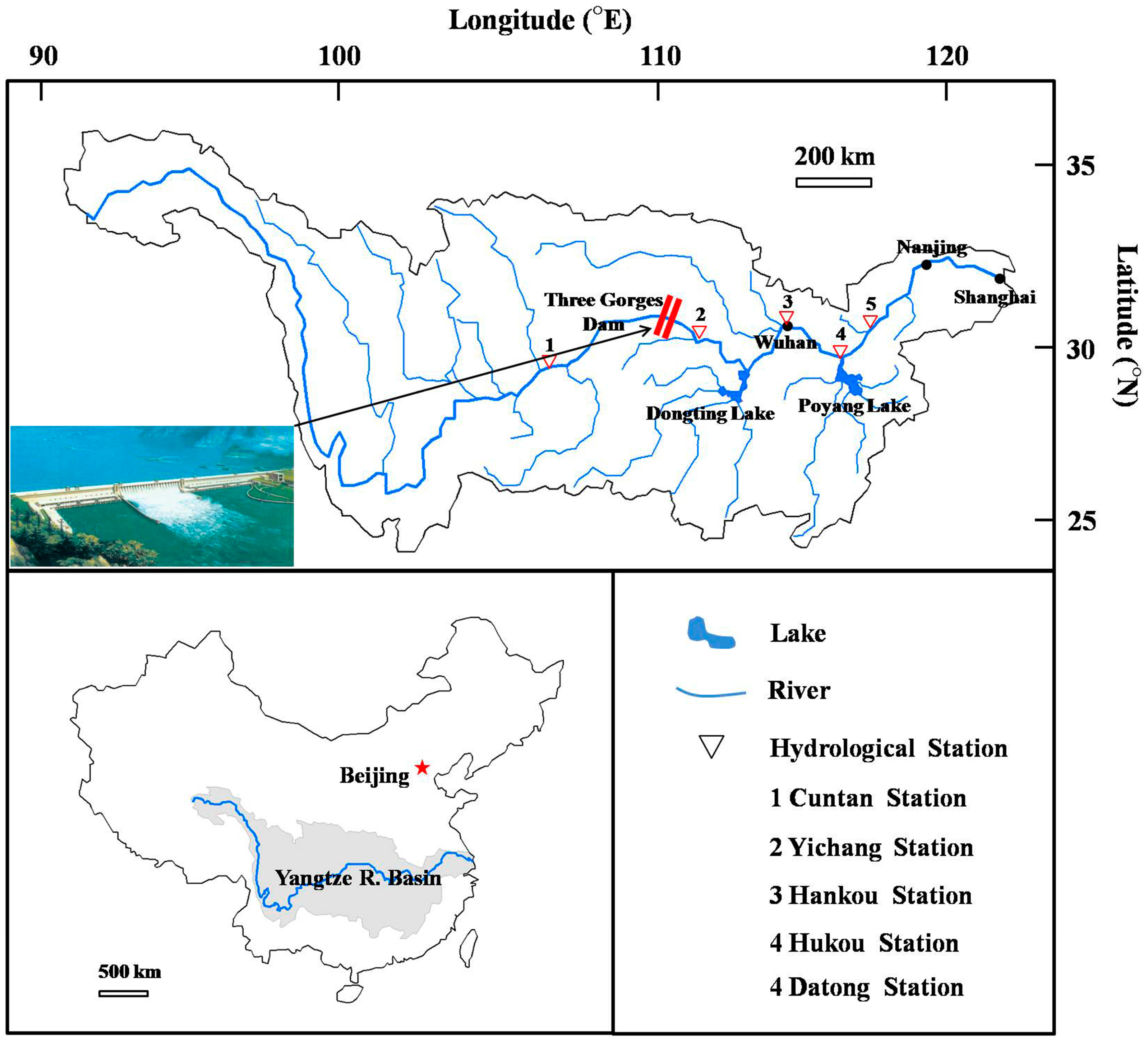
2. The Three Gorges Project

As the world’s largest hydraulic engineering project, the TGD has been the focus of public attention and academic debate ever since the project planning and construction stage. Due to negative experiences associated with construction of the Gezhouba Dam (a warm-up project for the TGD) without having conducted proper feasibility studies, the Chinese government took a more cautious attitude towards the development of the TGD. They insisted that a feasibility study and environmental impact report be prepared before proceeding with the construction of the TGD. This assessment involved a long and complicated evaluation process, during which experts and scholars from different disciplines were brought together to discuss the anticipated costs and benefits associated with the TGD [15]. Finally, a detailed research report that addressed aquatic biodiversity, lake and river hydrology, river channel sedimentation and scour, etc. was approved. After completion of the TGD, several scholars (e.g., [16]) compared runoff and sediment discharge loads before and after impoundment, while others used trend analysis and modeling studies to predict the future effects of the TGD under various scenarios [17,18]. These studies are reviewed later in this paper.
The initial TGD impoundment was initiated in 2003, raising the water level to 139 m. The second impoundment (which started in 2006), brought the water level to 156 m. Finally, in 2008 the full impoundment raised the water level to 172.8 m, maximizing the flood control potential of the project, and the historic highest water level of 175 m was experienced in 2010. After that, the TGD followed a prescribed pattern of operation. The regulating activities of the reservoir are described in detail below. In early June, as the flood season (June–September) approaches, the guidelines prescribe that the reservoir level be reduced below the flood control level of 145 m so as to increase the flood control capacity. During this period the discharge from the dam increases rapidly. During the flood season, the dam is operated so as to maintain a low water level, but when the discharge into the dam is relatively high, the water level is allowed to rise so as to attenuate the flood peak as it moves downstream. After the flood has passed, the water level is reduced to 145 m. Through the month of October the TGD begins storing water again, and so the discharge from the dam decreases. Finally, between late November and May of the following year, the dam is operated for the purpose of electricity generation, and so the releases are generally larger than they would be under natural conditions; during this period the water level must be maintained above 155 m. The impacts associated with the various modes of dam operation are described in the following sections.

3. Impact of the TGD on the Middle and Lower Reaches (Main Stream)

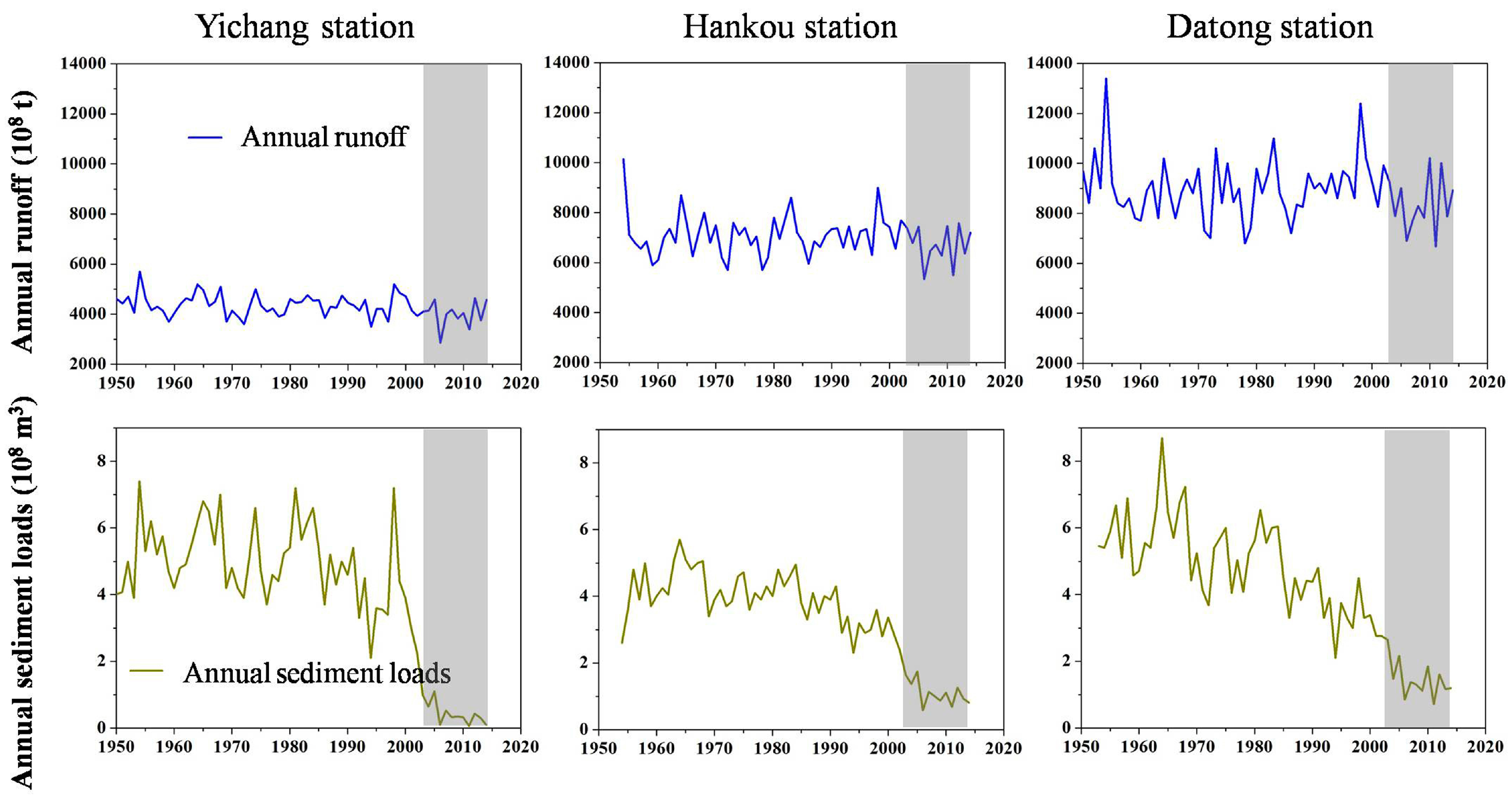
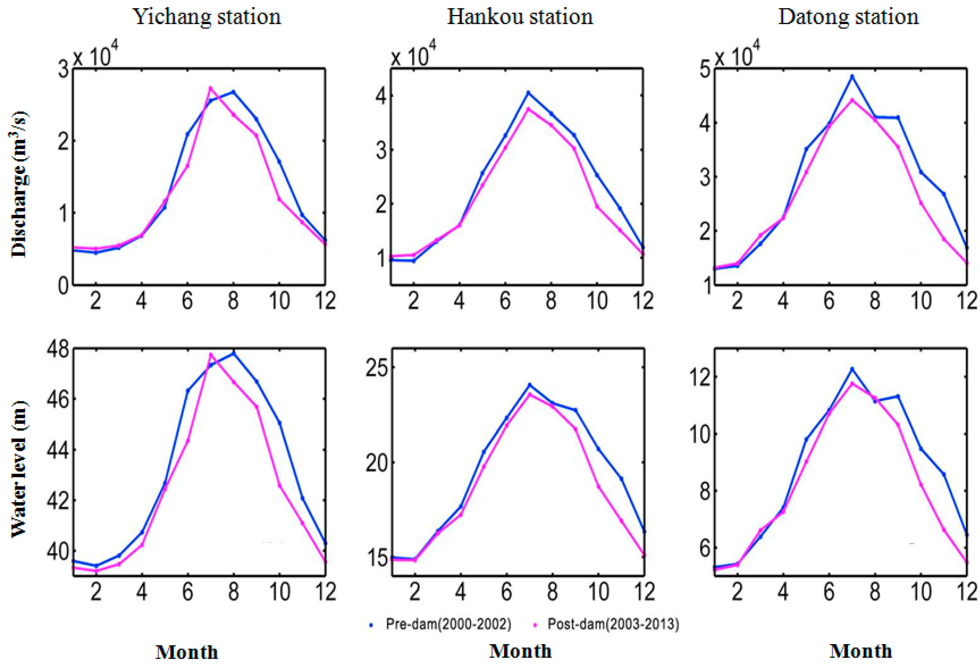
3.1. Hydrological Regime

Dam regulation can produce substantial alterations to the hydrological flow regime, especially with respect to flood magnitude and monthly flow pattern [12,19]. Operation of a dam typically disrupts the continuum of sediment pathways, producing severe alterations to the river hydrology, morphology and ecology, and causing damage to infrastructure [20]. The TGD is no exception, and imposes a strong influence on the downstream hydrological regime of the Yangtze River [21]. Based on linear regression and a Mann-Kendall trend analysis, Zhang et al. [22] found a clear decreasing trend for annual sediment loads at almost all of the gauging stations along the mainstream of the Yangtze River basin and its major tributaries (Figure 2).
In particular, after the initial closure of Three Gorge Dam in 2003, the annual sediment loads decreased dramatically compared to the pre-TGD period (Figure 2), as did the concentrations and loads of dissolved silicate (DSi) [23]. In contrast, no significant trend in annual runoff was detected. However, the seasonal variability in water discharge decreased, with downstream extremes being mitigated by a decrease in discharge maximums and an increase in discharge minimums [21,24], thereby reducing the contrast in the river flow between the dry and flood seasons [11] (Figure 3). There is no doubt, therefore, that the TGD has greatly reduced the magnitude and frequency of extreme events in the mainstream along the Yangtze River, and has thereby lowered the risk of intensive flooding and drought experienced by the population downstream of the dam.
Strong periodicities can be seen in the discharge record, corresponding to 7-, 14- and 38-year cycles, although slight variations in these cycles are evident at different time scales [11,25,26]. These cycles may be different due to climate change as the time scale is altered, so it can be estimated that the multi-year cycles will be potentially changed in future decades. In addition, dam operations can affect seasonal variations in water discharge, but in contrast, the annual discharge almost remains unchanged (Figure 2 and Figure 3). Thus, these multi-year discharge cycles can be attributed to climate variability and appear to not have been affected by operation of the reservoirs [26].
However, the shorter-term seasonality of hydrological processes in the Yangtze River has been significantly altered. The annual cycle of sediment loads has been seriously impacted by the construction of the dam, with the large pre-TGD seasonal variability being dramatically reduced due to entrapment of the sediment by the impoundment [16,25]. Whereas sediment load changes are primarily due to human activity (e.g., construction of water reservoirs, deforestation/afforestation), the variability in runoff variability is mainly the direct result of climatic changes that alter precipitation [6,25] and evapotranspiration. Zhao et al. [27] studied the correlation between stream flow and climate variables on both annual and seasonal basis, and concluded that dam operations have a secondary role on the variations in discharge. Accordingly, the TGD has had a much more significant influence on sediment transport than on runoff variability (Figure 2).
In contrast with what has been observed for other dams, these figures clearly show that TGD regulation has not had a significant impact on the downstream hydrological regime. The explanation for this is that the tributary inflows and adjoining riparian lakes of the Yangtze River weaken, to some extent, the effect of TGD on downstream hydrological behavior [21].
In general, there is considerable spatial variability associated with runoff and sediment discharge into the reservoirs. Accordingly, the impact of a dam varies with distance downstream from the dam and with reservoir capacity [12]. Almost all of the tributaries of the Yangtze are subject to a cascade of dams distributed along their mainstreams. Therefore, any target study site is generally influenced by the superposition of impacts by no fewer than one dam. We can therefore expect that the changes in patterns of runoff and sediment loads caused by the dams are different in different parts of the Yangtze River basin [22]. Of course, the TGD has the strongest regulating storage capacity and therefore imposes the predominant influence on its downstream reaches.
A clear spatial pattern in sediment discharge can be found along the middle and lower Yangtze River. After the impoundment, the release of clear water caused erosion of the riverbed and resulted in greater sediment loading at the Hankou station than at the Yichang station (Figure 1) [28]. In general, due to the intervening effect of the TGD, sediment loading at the Yichang station is the lowest, and has an increasing downstream trend, due to the combined effects of scour and the confluence of downstream tributaries.
Water level changes are clearly regulated by the dams and, being easily measured, are often used to estimate the hydrological regime. Wang et al. [29] reported alterations in the regime of downstream Yangtze levels (Figure 3), resulting from both flow regulation and degradation of the channels due to reductions in the sediment load. Although the TGD releases clear water into the downstream section, the turbulent flows cause large amounts of suspended sediments to be moved downstream, changing the morphological evolution of the river channel. Studies have indicated that the riverbed has changed from being accretionary (before the TGD) to erosional, with the riverbed showing strong, intermediate, and weak erosional modes depending on closeness to the TGD [30,31]. In particular, the channel between Yichang and Zhicheng (downstream of the TGD), has been very severely eroded [32], causing a decline in the elevation of the river bed and, correspondingly, an appreciable decrease of water level in the river over time, even though the river runoff has not shown any such trend [30].
Therefore, the dam has had a much more significant influence on the water level than on the discharge, although the seasonal variabilities of both have been reduced (Figure 3). Further, Mei et al. [21] reported that the maximum and minimum water levels downstream of TGD have both decreased in response to TGD-induced channel erosion, even though the annual maximum water level has increased due to other human activities during the pre-dam period [33].
Therefore, scouring caused by water released by the dam has reduced water levels and helped to ease the intensity of severe flooding in the middle and lower reaches. In contrast, significant siltation has occurred upstream of the TGD, especially between the TGD site and Cuntan, as a consequence of the upstream extension of the backwater region [34], and this has likely contributed to the additional increases in water levels upstream of the dam. A study of rating curves shows variations over time, attributable to variations in the river bedform [21]. Locations closer to the dam show the most significant variations, caused by more marked scour or deposition. Overall, it is clear that the relationship between discharge and water level along the Yangtze River has been significantly altered by the operation of the dam.

3.2. Ecology and Environment

Experience has shown that damming a river can have adverse effects on local and regional ecosystems and other environmental factors [35]. In the case of the TGD, Yi et al. [36] reported that the physical habitat of the aquatic organisms, including many rare species and fish with economic value, has been changed since the filling of the reservoir. The reductions in species populations are attributed mainly to the loss of spawning areas caused by dam construction. At the same time, hydrologic regimes play an important role in structuring the biotic diversity within a river ecosystem [37], and Huang et al. [38] reported that the change of hydrologic regime, due to the TGD operation, has affected fish diversity. For example, the spawning activity of the carp species depends upon adequate water flow for the eggs to be able to float.
Accordingly, a minimum instream flow and suitable increases in daily discharge are essential during the reproduction season. In this context, Morais et al. [35] recommend that dam managers mimic, as closely as possible, the natural dynamics of river flow, so as to minimize the impact on downstream ecosystems. To maintain sites that provide habitat suitable for the spawning of carp, reservoir operations may need to be adjusted to provide suitable water level fluctuations; this operation is called the “ecological operation mode” [39,40], and has already been partially implemented by the TGD.
Overall, however, continued future erosion of the downstream channel may further act to counteract the benefits ecological obtained by increasing the Yangtze levels (by releasing TGD water) in the winter/fall, and thereby accelerate the decline in the inundation areas/levels of downstream lakes [29]. The shrunken and simplified geomorphology of the Yangtze River, due to the operation of the TGD, has been expected to have direct adverse effects on riparian ecology [13], producing spatially smaller, less diverse riparian ecosystems as compared to the pre-dam period.
Further, with continuing economic growth, population size and increased living standards, the disposal of industrial effluents, raw sewage and agricultural chemicals into the Yangtze River is increasing [41], greatly sapping the Yangtze’s ecological vitality. Operation of the TGD can be expected to reduce the rivers’ ability to remove toxins and flush out pollutants. By attenuating the flood peak in the wet season, the effects of dilution are reduced which, together with extreme low levels, will tend to further deteriorate the quality of the water in the river. Besides, toxins are often adsorbed to the sediment particles, and most of these sediments are generally deposited upstream of the dam because of the interruption of the TGD, which can also worsen the water quality. Of the many victims of the declining quality of water in the Yangtze, two of the more high-profile mammals are the river dolphin and the finless porpoise. To achieve prompt detection of contamination hotspots, the Chinese government has sanctioned an ambitious program to monitor the Yangtze and the Three Gorges reservoir area [42].
In addition to adversely affecting the environment and its biodiversity, dams can also impact human health by altering the ecology of waterborne and parasitic diseases, such as schistosomiasis [43], and the Three Gorges Dam is no exception. Zhu et al. [44] suggested that the Three Gorges Dam can lead to schistosomiasis epidemics by altering the environment both within the Three Gorges region and in downstream areas. They also suggested that major changes in the demographics and agricultural practices of the Three Gorges and the downstream Yangtze areas (caused by the dam) could exert a significant influence on the transmission of schistosomiasis in these regions [44]. In particular, the decline in magnitude and frequency of floods can be linked to aggravation of this situation, since floods are commonly used as a method to control snail populations [45]. In this context, the report by Seto et al. [43] indicates that the increased stability of water levels downstream from the dam can be linked to decreases in the mean and variance of snail densities, which may help to restrain the transmission of schistosomiasis. However, although overall snail densities may decrease with lower and more stable water levels, the density of infected snails and corresponding human infection can increase due to the co-location of buffalo grazing areas, snail habitat, and human activity that may occur due to the increased stability of water levels. It seems clear that more research needs to be conducted to better understand how the changes in flow patterns affect the occurrence of schistosomiasis.

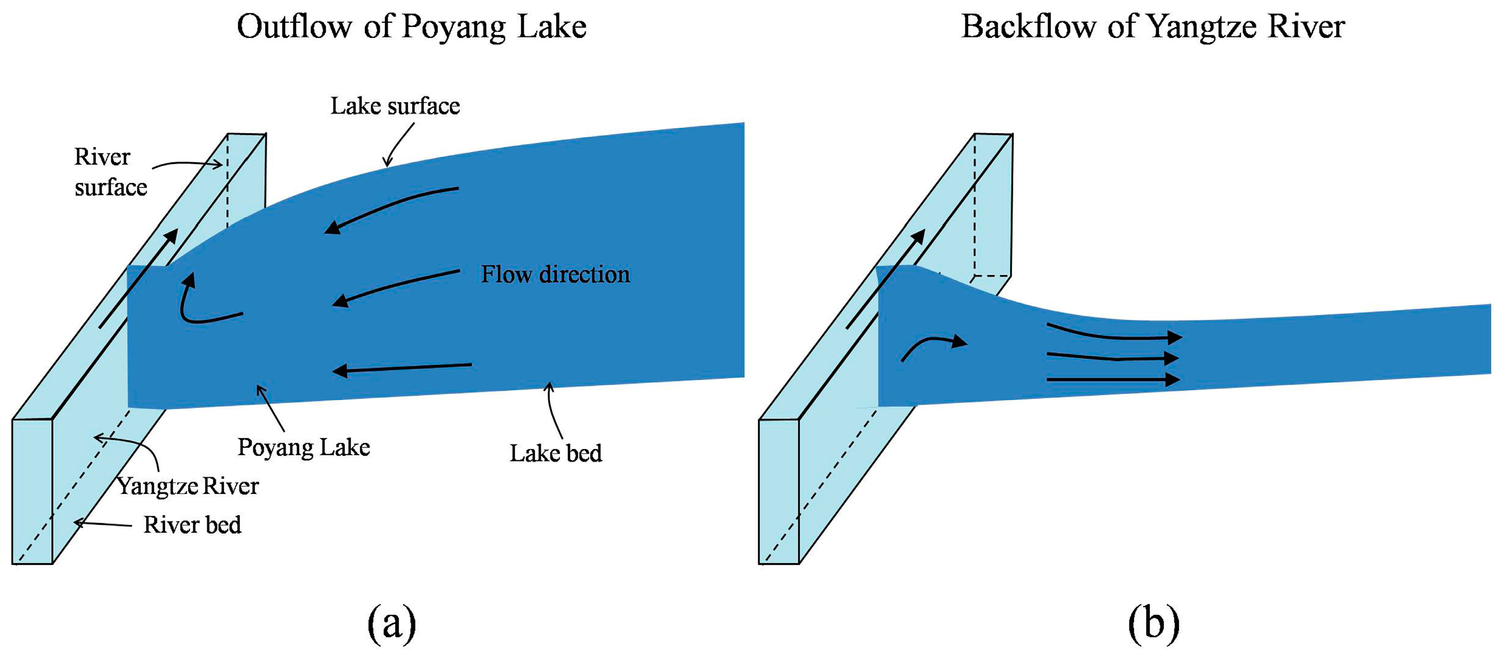
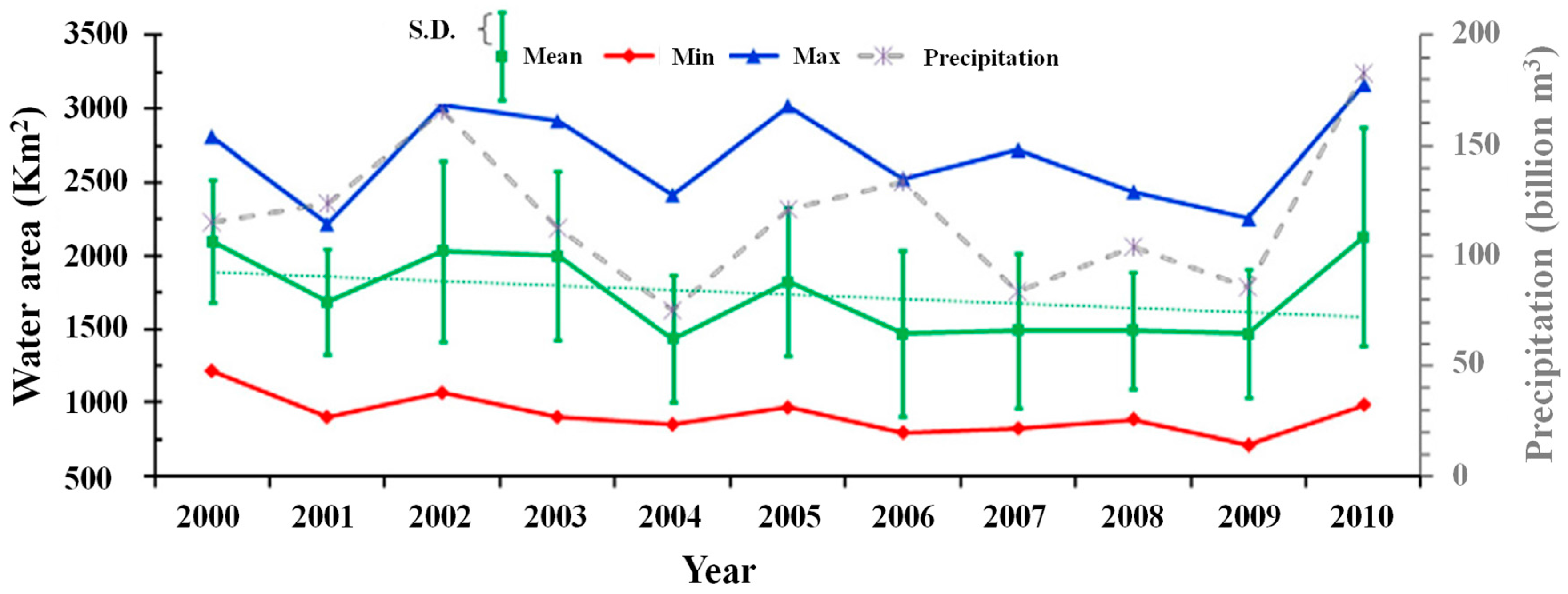
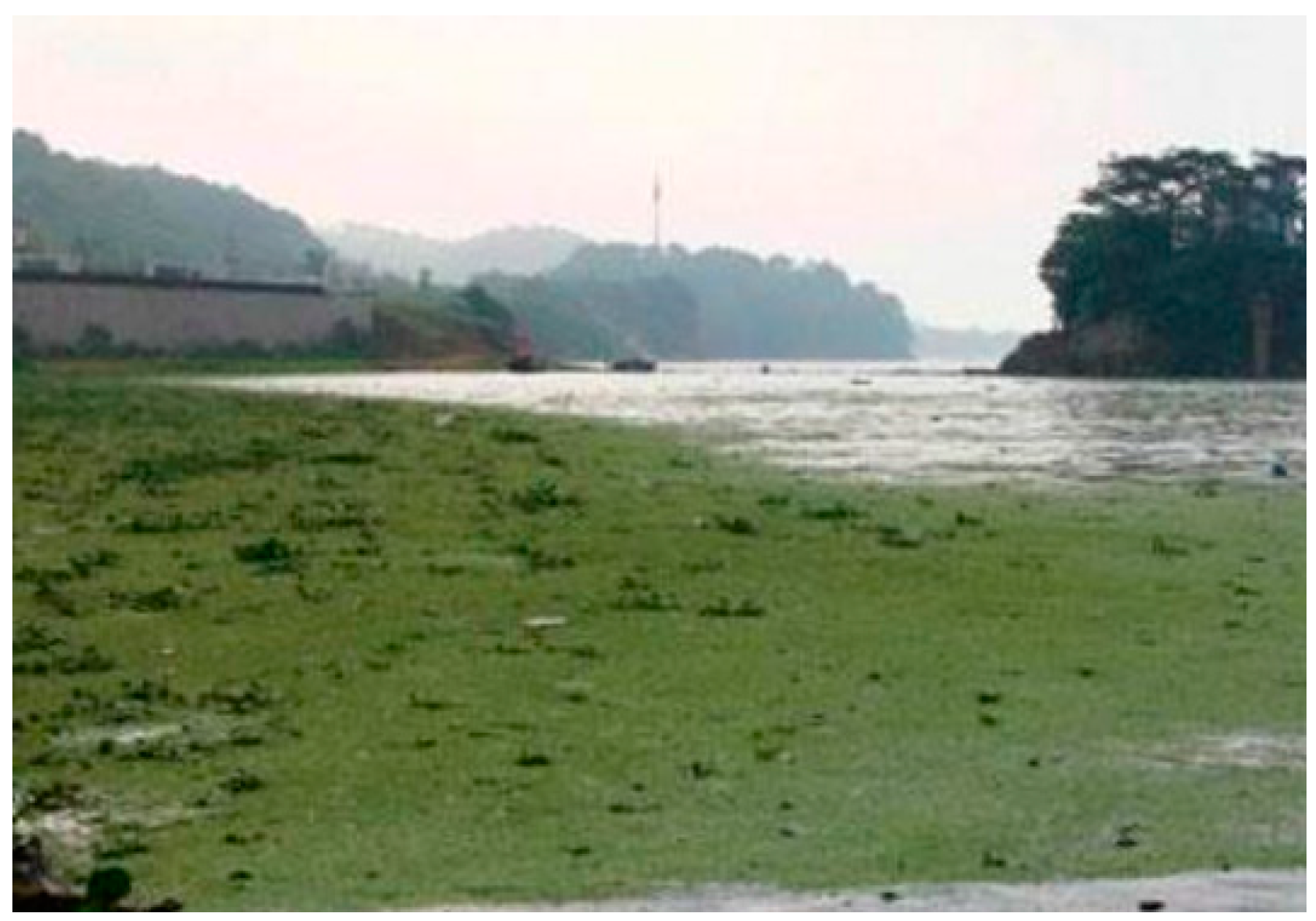
4. Impact of the TGD on Poyang Lake

4.1. Hydrological Regime

Poyang Lake lies on a key tributary of the Yangtze River downstream of the TGD, and it is China’s largest body of fresh water. The lake is associated with one of the four largest wetland systems in China, and provides an important habitat for migratory birds. The functioning and extent of this ecosystem is sensitive to annual and seasonal fluctuations in water levels of the Poyang Lake, which are inevitably affected by the operation of the TGD. In this regard, the TGD makes two rapid and significant changes in the pattern of its discharges to the middle and lower Yangtze River. The first is the rapid release of water in late May to early June, with the purpose of increasing the reservoir’s storage capacity for flood mitigation. The second is the rapid impoundment of water between October and November (by reducing the TGD’s releases), with the purpose of increasing the water level for power generation [24].
The increased discharge rates in May–June can be large enough to raise the river water level at the mouth of Poyang Lake (Hukou), which acts to constrain the drainage of the lake to the Yangtze River (blocking effect). Whenever this happens at a time that coincides with the rainy season, the flooding impact on the lake is further worsened. In contrast, the reduced discharge rates in October–November result in lower water levels at the mouth of Poyang Lake, thereby increasing the rate of drainage from the lake (emptying effect). Since this leads into the dry season, the effect is to intensify the drought in the lake area during the dry season [46]. Accordingly, operation of the TGD acts to intensify the extremes of wet and dry conditions in Poyang Lake, and thereby adversely affects the health of the important local wetland areas [46]. As pointed out by Guo et al. [47], the strength of the impact depends on the impound and release rates, and on the seasonal pattern of flow in the river.
In this context, the water level in the Poyang Lake is primarily controlled by two factors, one being the interaction between the lake and the river level at the lake outlet (river effect, Figure 4) and the second being the strength of the inflows from the five rivers that flow into the lake (basin effect) [48]. During the dry seasons of 2003–2010, the discharge from Poyang Lake towards the Yangtze River catchment increased by 8.98 km3/year relative to the period 1956–1989 [49]. Meanwhile the inflows to the lake in late April–late May (spring) decreased. Together, the effect was an increase in the frequency of spring season droughts after 2003. For example, the droughts of 2006 and 2011 were more severe than any during the past 60 years.
In comparison, the impact of reservoir operation on reduced water levels in the lake during autumn (September–October) was much stronger. Reduced precipitation (due to variations in climate) combined with the increased impoundment of water to reduce the river level at the mouth of Poyang Lake, resulting in greater than usual outflow from the lake and thereby worsening the shortage of water in the lake [50]. On top of this, severe scouring of the mainstream channel caused the riverbed elevation to be further lowered, increasing the lake–river topographic gradient. This further weakened the blocking effects of the Yangtze River and increased the rate of discharge from the lake, thereby aggravating the condition of water scarcity in the lake basin during the dry season.
By weakening the blocking effect of the Yangtze River, the operation of the TGD has caused changes to the lake. Recently, Poyang Lake has shrunk rapidly in size (Figure 5), and Liu et al. [51] have suggested that the principal cause of the recent decline is the weakened blocking effect. Zhang et al. [52] showed clearly that the average frequency and quantity of water and sediment backflow (Figure 4) have been reduced since the implementation of the TGD, and Feng et al. [53] reported that there has been a lake–river outflow of 760.6 million m3/day, resulting in a loss of 7864.5 million m3 of water from the lake in a relatively short period of time. Feng et al. [54] found statistically significant declining trends for both the annual mean and minimum inundation areas, and Feng et al. [55] observed a decreasing trend of 3.3%/year in the areas inundated by Poyang Lake downstream (Figure 5).
Meanwhile, the relative humidity and surface runoff coefficient for the lake drainage area has declined dramatically [55]. The rapid decline in surface runoff coefficient coincides with a decline in groundwater levels in the lake basin, indicating that some of the precipitated water has gone towards recharging the groundwater system instead of generating surface runoff. Of course, during dry conditions, the seepage of groundwater back into the lake will help to sustain the lake [10]. Overall, the recent decline in Poyang Lake should not be viewed as a long-term trend but as a complete regime shift [51].

4.2. Ecology and Environment

Overall, the hydrological regime of Poyang Lake has been changed relative to the mainstream. For the mainstream, the magnitude and occurrence of extreme events (floods and droughts) has been reduced. For example, in 2006 (the driest year in the past 60 years), no drought was experienced along the mainstream during the dry season due to releases of water from the TGD [56]. In contrast, the lake basin experienced more frequent extreme events, and these have significantly affected the functions of ecological and environmental systems in the lake.
Alterations in hydrological processes can significantly affect the availability, spatial and temporal distribution, and quality of water, causing eco-environmental problems to emerge, thereby triggering modifications to the biota of the Poyang Lake basin [52], and resulting in impacts on the biodiversity and quality of local ecosystems (e.g., giving rise to schistosome). Changes in water level and lake extent can destroy the delicate habitat that is relied upon by migrating birds. In Poyang Lake, the big draw for cranes and other migratory birds is its shallow waters and marshes, ideal for wading and spearing fish with bills [14]. However, these vital wintering grounds may be at risk. Filling of the TGD at the beginning of October brings about significant water level decline in the reservation areas of Poyang Lake basin, causing earlier drying of the marshlands, so that when the migrant birds (including Siberian cranes and swans) arrive in November there is less food available; this alters the balance of the ecosystem and results in a decline of many valuable species. Similarly, when TGD discharge is increased in March, the outflow from Poyang Lake reduces, causing the marshlands to be submerged earlier, reducing the activity areas suitable for migrant birds and the amount of food available to them. To minimize ecosystem damage and support conservation of wintering waterbirds, planning is needed to ensure that Poyang Lake water level ranges are maintained within suitable ranges.
Of course, the local fish species face similar challenges to their survival. Poyang Lake has been an important base for commercial fishery in China, and its fish resources have been decimated since construction of the TGD, resulting in huge economic loss to the local fishermen. A direct cause of this is the lack of suitable flow conditions for the spawning of fish. In addition, falling water levels caused by the TGD in October may result in more fish being carried by the outflows into the Yangtze River.
Another impact of the TGD has been changes to the self-purification ability of the lake. Between late November and May, the higher than normal TGD releases block the outflows from Poyang Lake so that the average “age” of the lake water is increased. The reduced rates of flow tend to aggravate any local contamination hotspots. Meanwhile, there is more time for suspended particles to be deposited resulting in clearer lake water, and increased photosynthesis leads to the increase of organic biomass, resulting in greater levels of eutrophication [57]. The latest severe bloom of blue-green algae occurred on 12 June 12 2015 (Figure 6) and such blooms are likely to reoccur frequently if not controlled.
Finally, as mentioned earlier, Poyang Lake is one of the largest schistosomiasis endemic environments in China. The spring blocking effect contributes to increased sedimentation rates and longer ponding of the marshland areas which, when combined with the patterns of seasonal precipitation, facilitate the transmission of schistosomiasis and expand the areas affected by schistosomiasis epidemics.

5. Impact of TGD on the Estuary

5.1. Hydrological Regime

Estuaries are highly dynamic ecosystems that are generally subject to both tidal effects and variations in river inflow [35]. At the same time, climate change-driven variations in sea water level and wave conditions potentially affect the dynamic estuarine systems [58,59] River inflows, including the sediment discharge brought with them, are crucial to the environmental conditions, biodiversity, morphological configuration, and development, etc., of the estuary [35,60], and vital for the ecological health and sustainable economic growth of the Yangtze River Delta (YRD), the most developed region in China. Inflows to the Yangtze River estuary are significantly affected by the TGD [30], with data indicating a significant decreasing trend in both total and minimum annual discharges from the Yangtze River to the sea [26,61,62]. These declines can be interpreted as being partially the result of enhanced evaporation of water from the reservoirs and partially due to enhanced rates of water abstraction [62]. These declines in annual discharge have impeded the socio-economic development of the YRD.
Perhaps more importantly, declines in the annual sediment discharges into the YRD threaten the very existence of the delta. Worldwide, the flux of sediment reaching the coastal areas has been greatly reduced because of retention within reservoirs [63], and due to disruption in the balance of scour and sedimentation within estuary and coastal areas [60,64], resulting in the progressive destruction of the deltas of many major rivers during the past 150 years. For example, the Nile delta was severely eroded in response to the closure of the High Aswan Dam [65]. There is no doubt that changes in the Yangtze estuary are subject to the operation of the TGD. The closure of the TGD trapped massive sediments, and thereby clear water released by the dam posed a significant threat to the estuarine regions. Overall, the increase in erosion of the riverbed downstream of the TGD has not offset the sediment lost in the reservoir, only compensating for about 20% of reduction from the pre-dam sediment discharge levels.
It is likely that the sediment load delivered to the Yangtze estuary will continue to decrease, putting pressure on the Yangtze lower reaches and adjacent coastal areas [5,16,31,66]. Among the results of sediment starvation, coastal salt marsh accretion has been reduced and net erosion of the subaqueous delta front has been observed by Yang et al. [45]. Yang et al. [67] reported that decreased sediment discharge has led to conversion from progradation to recession in the delta front. Based on the modeling results of Gao [17], overall coastal erosion will take place due to the sediment discharge not being larger than 200 million t/year since 2006.
Of considerable concern is the fact that the various dams now under construction or in the planning stages (e.g., the Wudongde, Baihetan, Xiluodu, and Xiangjiaba, all located along the mainstream Yangtze River), will add a total water storage capacity that is equivalent to that of the TGD [32], and can be expected to alter the Yangtze River even further, exacerbating degradation of the estuary. Full operation of the South-to-North Water Diversion in the watershed will also further reduce the sediment load to the estuary.
Interestingly, various scholars are of the opinion that the situation will not be as bad as some “pessimists” have suggested. For example, Yang et al. [67] estimated that erosion and accumulation of the delta would gradually balance out by 2060 (Table 2), even though the decrease of the sediment flux into the estuary would last for centuries [4]. Further, Yang et al. [31] suggest that sediment flux to the estuary is unlikely to fall below 10 × 1010 kg/year over the next 50 years. More surprising is that Dai et al. [64] report only minor erosion of the Yangtze submerged delta, although a significant threat remains due to the influence of the TGD. In this regard, it is known that rivers display some degree of natural ability to maintain equilibrium despite alterations in their hydrologic regimes [68].
In the case of the YRD, the modulating effect of deposition and erosion within the main river system on sediment delivery to the estuary appears to have played an important role in the restoration of the delta ecosystem. The relatively moderate impact of the TGD on the delta (compared to other river dam systems around the world) may be due to two factors. One is that the Hanjiang River (the largest tributary of the Yangtze River) and Poyang Lake (the largest freshwater lake in China) may be moderating the effects of TGD on the downstream delta. For example, sand mining in the Poyang Lake is reported to cause re-suspension of fine deposits, which leads to an increase in the downstream delivery of sediments to the delta [31]. The other is that riverbed erosion decreases with the distance from the outlet of the TGD [12,30], and given the long distance of almost 2000 km, erosion in the estuary is relatively weak. Besides, as we know, estuarine systems are governed by pressures from both the terrestrial and the marine fields, so the significance of drivers from the coastal environment for the evolution of the YRD should not be neglected as well. Tidal waves propagating from oceans play an important role in shaping river estuaries [69], but literature references that consider the impact of ocean waves on the YRD are scarce. Therefore, in order to thoroughly understand the evolution of the YRD under anthropic and climatic pressures, an integrated approach including both the terrestrial and coastal fields [70,71] is urgently needed.

5.2. Ecology and Environment

By significantly decreasing the flows into the estuary (from the upstream Yangtze River), operation of the TGD can alter the balance of freshwater and sea water, resulting in the intrusion of saltwater into the estuary. High concentrations of salt in the local groundwater can make the soils less productive, and thereby impact the sustainability of local agriculture. Further, it has been reported that dissolved inorganic nitrogen (DIN) and dissolved inorganic phosphate (DIP) in the river water have been following a strong upward trend due to the increase of the population and the use of large-scale chemical fertilizers in the Yangtze River basin [41,72]. During periods when water is being impounded by the TGD, stagnant water in the backwater regions of the TGD tends towards eutrophy and worsens the water quality. When the impoundment period is over, the contaminated water is washed downstream to the mouth of river, and the consequent sharp decrease in the ratio of DSi/DIN and the increase in the ratio of DIN/DIP causing increased occurrences of red tide and decreased dissolved oxygen in the Yangtze Estuary [72]. Müller et al. [41] have suggested that the enormous contaminant loads could eventually be disastrous to the health of the Yangtze estuary, with the cocktail of inorganic nitrogen, phosphorus, oil hydrocarbons, organic matter and heavy metals fueling major algal blooms and red tide occurrences. Undoubtedly, such deterioration of water quality would aggravate the shortage of water resources and further damage the estuarial ecosystem.
Meanwhile, the decline in sediment flux along the Yangtze River has serious downstream implications. Coastlines and deltas are particularly vulnerable to declines in sediment feeding. Prior to construction of the TGD, the estuary relied upon food-borne sediment loads to supply nutrient-rich sediments to the soil, riparian vegetation and aquatic ecosystem. Due to the frequency and magnitude of floods (and the amount of sediment delivered downstream) having been reduced by construction of the dam, the productivity of these areas in the river mouth is under threat [10,68].
Finally, river inflows are among the most important factors determining abiotic and biotic variability. Morais et al. [35] reported on how construction of the Alqueva dam, the biggest dam in Europe, has affected the Guadiana estuarine anchovy. They found that the changed pattern of discharge affected the dynamics of nutrient stoichiometry, leading to a decrease in estuarine productivity and consequent reduction of the abundance of anchovy eggs. A likely causal factor is the low inflow rates during the period of impoundment (early October to November). However, there are almost no relevant reports in the literature. It would be prudent for scientists to pay more attention to the impacts of the TGD on abiotic and biotic activities in the estuary.

6. Concluding Thoughts and Suggestions

6.1. Would It Be Feasible to Build a Dam at the Outlet of Poyang Lake?

In recent years, the frequency of extreme variations in climate has increased [7,10]. With this in mind, Zhao et al. [27] and Ye et al. [18] have speculated that there is a potential threat of both increased flooding and periods of water shortage in Poyang Lake basin over the next few decades. To relieve the pressure of floods and droughts on the ecosystem, environment and humans in the lake basin, a variety of strategies could be followed.
One possible strategy might be careful land-use planning to achieve specific hydrological effects in the basin, by which it might be possible to mitigate some of the undesirable effects of climate change on the local environment and its water resources. Guo et al. [73] have suggested that by increasing forest cover (via returning agricultural lands to forested biomes) one could reduce the magnitudes of wet season streamflow (greatly reducing flood potential) while raising it during dry season (reducing drought severity). Nakayama and Shankman [10] have proposed that by mining sands and constructing levees in lakes one can reduce flood risk to a significant extent.
By contrast, building a dam at the outlet of Poyang Lake would be a more direct, and potentially more effective, way to control water levels in the lake. Of course, the implications would need to be carefully studied, as improper design and/or operation could give rise to further problems, and detailed research would be necessary before such a project is launched. Some experts have suggested that building a dam/sluice at the outlet to Poyang Lake is a clear solution to reducing the river effect, with the advantage that it can be used to control the water level of Poyang Lake and bring significant ecological and economic benefits to the local people [50,55].
However, other experts have opposed the dam, claiming that dam’s costs would outweigh its benefits, and that stabilizing the Poyang water levels would trigger a fundamental change in the wetland ecosystem [14]. These opponents include some of the provinces downstream along the Yangtze River, as well as various environmental protection advocates. Because some of these downstream provinces are faced with water supply challenges, construction of a dam at Poyang Lake is likely to makes it even more difficult to obtain enough water during the dry season. In addition, the interruption of the dam can reduce the sediments out of the lake, and consequently lead to a reduction from the lake to the coastal systems, which undoubtedly worsens the degradation of the estuarine areas. Besides, larger winter water depths could dramatically impact the populations of rare water birds and could lead to extinction of the Siberian crane due to the inaccessibility of food. In addition, the dam would impede the pathway of fish that migrate between the Yangtze River and Poyang Lake, thereby impacting the life-cycle of the fish populations; for example, it could prevent the environmentally-threatened and rare Yangtze finless porpoises from reaching their spawning areas. Because the dam would alter the flow rates of lake water, it could increase the risk of eutrophication if the upstream pollutant loads are not controlled.
In response, backers of the dam proposal have argued that keeping the sluices open from April to October, when the water level is higher, would allow free passage between the lake and the Yangtze for fish and porpoises [14]. They further suggest that, to satisfy the requirement for migratory bird habitats, the water level of the lake can be suitably regulated. They also believe that the dam operators can guard against the risk of increased eutrophication risk.
This water-control structure, known as “the second TGD”, was proposed in 1980, and the discussion has continued for 36 years. Recently, the project was approved by National Development and Reform Commission, and the “water resources justification for Poyang Lake water conservancy project” has been commissioned by the government of Jiangxi Province, indicating that the water control project is likely to be implemented in the near future.
Since it will be important to also address the problem of water supply shortage in the downstream provinces, in addition to ensuring that the functioning and value of the wetland are maintained, we make the following suggestions:
(1)
More research should be conducted to determine the appropriate level for the lake (e.g., [74]) and how best to operate the dam so as to minimize its adverse influences.
(2)
Intra-provincial and inter-provincial hearings should be held on a large scale.
(3)
Joint operation of the TGD and Poyang Lake dams should be required so as to optimize the allocation of Yangtze water resources.
(4)
A regional monitoring network should be set up to provide managers with real-time data for use in decision making.

6.2. How to Manage the Water Resources of Yangtze River Basin

During the period of impoundment of the TGD, the decreased flow had significant impacts on downstream water supplies (e.g., Shanghai City), especially during dry years, and a dam at the outlet of Poyang Lake (PD) would further reduce the flow of water. Meanwhile, if the South-to-North Water Transfer Project (SNWTP) delivers Yangtze water to the Northern China, water discharges to the sea will be further reduced. Such large-scale water diversion is likely to significantly worsen the water shortage, especially during droughts, if left uncontrolled or mismanaged. Within the estuary, the decreasing trend in annual discharge is likely to continue because of water consumption and the construction of new dams within the river basin. In consideration of the widespread ban on groundwater use in lower reaches of Yangtze, surface water is their only water source for people in these areas (including Shanghai City).
It seems clear, therefore, that an integrated management system is necessary to ensure that sufficient freshwater discharge into the estuary is sustained [61]. To meet the simultaneous demand for water, energy, and environmental protection well into the future, plans for the joint operation of TGD, PD and SNWTP should be developed, so as to optimize the potential uses of water resources. In addition, improved long-term predictions, based on tracking the behavior of El Niño-Southern Oscillation (ENSO) [75,76,77], would help provide managers with the information necessary for taking wise measures in advance.
For sustainable social and economic development to occur, sound water management strategies are required. Nakayama and Shankman [10] point out that conventional supply-and-demand management measures may not be an optimal way to deal with water imbalances. In addition, a shift towards water-efficient crops and consideration of virtual water trade will be necessary, based on a holistic view of the available water resources, including surface water and groundwater on the basin or trans-boundary regional scale.

6.3. Concluding Remarks

The TGD has significantly altered the downstream hydrological regime of the Yangtze River. While average annual runoff has remained nearly constant, the annual sediment discharge has been sharply reduced, resulting in a transition of riverbed sedimentation from accretionary before the TGD to erosional afterwards. The increased river channel erosion has compensated only slightly for the decrease in sediment discharge, and the overall sediment load to the estuary has declined significantly despite the confluence of downstream tributaries.
In addition, the seasonality of hydrological processes in the Yangtze River has been altered; water discharge is reduced during the period of impoundment (early October to November) and increased afterward (till June of the following year). Overall, the water level in the river has decreased appreciably, to a significant extent reducing the magnitude and frequency of extreme events along the mainstream. However, the Poyang Lake basin has been adversely affected by the operation of the TGD, and is at risk of experiencing more frequent extreme events.
The altered hydrological regime has affected the function of ecological and environmental systems along the Yangtze River. Although reducing the threat of flooding, the TGD has imposed a seasonal impact on availability downstream of water, and increased the risk of damage to the natural wetlands due to changes in inundation conditions. The reduced downstream sediment discharge has changed the morphological evolution of the river channel and the hydrological regime of the lake wetlands. The ecosystems of Poyang Lake and the delta areas are amongst the most severely damaged, posing threats to the survival of migrant birds and aquatic fish, and affecting human health in the lake basin. The changed inundation patterns have facilitated the transmission of schistosomiasis, aggravated contamination, and resulted in the eutrophication of Poyang Lake. During the post-dam period, lower discharges cause stronger saltwater intrusion into the estuary, affecting already scarce freshwater resources. The deterioration in water quality aggravates the shortage of water resources and contributes to damage of the estuary ecosystem. Overall, operation of the TGD has a significant impact on the productivity of areas in the river mouth.
To reduce the negative impacts of the TGD on Poyang Lake, we propose implementation of a long-term solution that can contribute to social justice and equity. Construction of a dam across the outlet of Poyang Lake would provide a direct and effective measure for the protection of the lake. Clearly, its feasibility and impacts would need to be properly investigated. And, considering the complexity of the river-lake system, joint operation of TGD, PD and SNWTP should be considered, so as to achieve an enhanced integrated water management strategy.

Acknowledgments

This work was supported financially by the National Natural Science Foundation of China (No. 41471014), the National Key Research and Development Plan (No. 2016YFC0402209) and the Colleges and Universities in Jiangsu Province Plans to Graduate Research and Innovation (No. 2014B35414).

Author Contributions

Xiao Zhang, Zengchuan Dong and Hoshin Gupta conceived and designed the experiments; Guangdong Wu and Dayong Li analyzed the data; Xiao Zhang wrote the paper.

Conflicts of Interest

The authors declare no conflict of interest.

References

  1. Chen, Z.; Li, J.; Shen, H.; Wang, Z.H. Yangtze River of China: Historical analysis of discharge variability and sediment flux. Geomorphology 2001, 41, 77–91. [Google Scholar] [CrossRef]
  2. Xu, K.; Milliman, J.D.; Xu, H. Temporal trend of precipitation and runoff in major Chinese Rivers since 1951. Glob. Planet. Chang. 2010, 73, 219–232. [Google Scholar] [CrossRef]
  3. Zong, Y.; Chen, X. The 1998 flood on the Yangtze, China. Nat. Hazards 2000, 22, 165–184. [Google Scholar] [CrossRef]
  4. Yang, S.L.; Milliman, J.D.; Li, P.; Xu, K. 50,000 dams later: Erosion of the Yangtze River and its delta. Glob. Planet. Chang. 2011, 75, 14–20. [Google Scholar] [CrossRef]
  5. Yang, Z.S.; Wang, H.J.; Saito, Y.; Milliman, J.D.; Xu, K.; Qiao, S.; Shi, G. Dam impacts on the Changjiang (Yangtze) River sediment discharge to the sea: The past 55 years and after the Three Gorges Dam. Water Resour. Res. 2006, 42, 501–517. [Google Scholar] [CrossRef]
  6. Xu, J.; Yang, D.; Yi, Y.; Lei, Z.; Chen, J.; Yang, W. Spatial and temporal variation of runoff in the Yangtze River basin during the past 40 years. Quat. Int. 2008, 186, 32–42. [Google Scholar] [CrossRef]
  7. Jiang, T.; Su, B.; Hartmann, H. Temporal and spatial trends of precipitation and river flow in the Yangtze River Basin, 1961–2000. Geomorphology 2007, 85, 143–154. [Google Scholar] [CrossRef]
  8. Li, X.; Zhang, Q.; Xu, C.Y.; Ye, X. The changing patterns of floods in Poyang Lake, China: Characteristics and explanations. Nat. Hazards 2015, 76, 651–666. [Google Scholar] [CrossRef]
  9. Yin, H.; Li, C. Human impact on floods and flood disasters on the Yangtze River. Geomorphology 2001, 41, 105–109. [Google Scholar] [CrossRef]
  10. Nakayama, T.; Shankman, D. Impact of the Three-Gorges Dam and water transfer project on Changjiang floods. Glob. Planet. Chang. 2013, 100, 38–50. [Google Scholar] [CrossRef]
  11. Dai, Z.; Liu, J.T.; Xiang, Y. Human interference in the water discharge of the Changjiang (Yangtze River), China. Hydrol. Sci. J. 2015, 60, 1770–1782. [Google Scholar] [CrossRef]
  12. Batalla, R.J.; Gomez, C.M.; Kondolf, G.M. Reservoir-induced hydrological changes in the Ebro River basin (NE Spain). J. Hydrol. 2004, 290, 117–136. [Google Scholar] [CrossRef]
  13. Graf, W.L. Downstream hydrologic and geomorphic effects of large dams on American rivers. Geomorphology 2006, 79, 336–360. [Google Scholar] [CrossRef]
  14. Li, J. Scientists line up against dam that would alter protected wetlands. Science 2009, 326, 508–509. [Google Scholar]
  15. Fu, B.J.; Wu, B.F.; Lü, Y.H.; Xu, Z.H.; Cao, J.H.; Niu, D.; Yang, G.S.; Zhou, Y.M. Three Gorges Project: Efforts and challenges for the environment. Prog. Phys. Geogr. 2010, 34, 741–754. [Google Scholar] [CrossRef]
  16. Xu, K.; Milliman, J.D. Seasonal variations of sediment discharge from the Yangtze River before and after impoundment of the Three Gorges Dam. Geomorphology 2009, 104, 276–283. [Google Scholar] [CrossRef]
  17. Gao, S. Modeling the growth limit of the Changjiang Delta. Geomorphology 2007, 85, 225–236. [Google Scholar] [CrossRef]
  18. Ye, X.; Zhang, Q.; Bai, L.; Hu, Q. A modeling study of catchment discharge to Poyang Lake under future climate in China. Quat. Int. 2011, 244, 221–229. [Google Scholar] [CrossRef]
  19. Magilligan, F.J.; Nislow, K.H. Changes in hydrologic regime by dams. Geomorphology 2005, 71, 61–78. [Google Scholar] [CrossRef]
  20. Villanueva, R.J.B. Sediment deficit in rivers caused by dams and instream gravel mining: A review with examples from NE Spain. Cuaternario Geomorfología Revista Sociedad Española Geomorfología Asociación Española Estudio Cuaternario 2003, 17, 79–91. [Google Scholar]
  21. Mei, X.; Dai, Z.; Gelder, P.H.A.J.M.; Gao, J. Linking Three Gorges Dam and downstream hydrological regimes along the Yangtze River, China. Earth Space Sci. 2015, 2, 94–106. [Google Scholar] [CrossRef]
  22. Zhang, Q.; Xu, C.Y.; Becker, S.; Jiang, T. Sediment and runoff changes in the Yangtze River basin during past 50 years. J. Hydrol. 2006, 331, 511–523. [Google Scholar] [CrossRef]
  23. Dai, Z.; Chu, A.; Stive, M.; Du, J.; Li, J. Is the Three Gorges Dam the cause behind the extremely low suspended sediment discharge into the Yangtze (Changjiang) Estuary of 2006? Hydrol. Sci. J. 2011, 56, 1280–1288. [Google Scholar] [CrossRef]
  24. Gao, B.; Yang, D.; Yang, H. Impact of the Three Gorges Dam on flow regime in the middle and lower Yangtze River. Quat. Int. 2013, 304, 43–50. [Google Scholar] [CrossRef]
  25. Zhang, Q.; Chen, G.; Su, B.; Disse, M.; Jiang, T.; Xu, C.Y. Periodicity of sediment load and runoff in the Yangtze River basin and possible impacts of climatic changes and human activities. Hydrol. Sci. J. 2008, 53, 457–465. [Google Scholar] [CrossRef]
  26. Yang, S.L.; Liu, Z.; Dai, S.B.; Gao, Z.X.; Zhang, J.; Wang, H.J.; Luo, X.X.; Wu, C.S.; Zhang, Z. Temporal variations in water resources in the Yangtze River (Changjiang) over the Industrial Period based on reconstruction of missing monthly discharges. Water Resour. Res. 2010, 46. [Google Scholar] [CrossRef]
  27. Zhao, G.; Hörmann, G.; Fohrer, N.; Zhang, Z.; Zhai, J. Streamflow trends and climate variability impacts in Poyang Lake Basin, China. Water Resour. Manag. 2010, 24, 689–706. [Google Scholar] [CrossRef]
  28. Zhang, Q.; Singh, V.P.; Chen, X. Influence of Three Gorges Dam on streamflow and sediment load of the middle Yangtze River, China. Stoch. Environ. Res. Risk Assess. 2012, 26, 569–579. [Google Scholar] [CrossRef]
  29. Wang, J.; Sheng, Y.; Gleason, C.J.; Wada, Y. Downstream Yangtze River levels impacted by Three Gorges Dam. Environ. Res. Lett. 2013, 8, 575–591. [Google Scholar] [CrossRef]
  30. Dai, Z.; Liu, J.T. Impacts of large dams on downstream fluvial sedimentation: An example of the Three Gorges Dam (TGD) on the Changjiang (Yangtze River). J. Hydrol. 2013, 480, 10–18. [Google Scholar] [CrossRef]
  31. Yang, S.L.; Zhang, J.; Dai, S.B.; Li, M.; Xu, X.J. Effect of deposition and erosion within the main river channel and large lakes on sediment delivery to the estuary of the Yangtze River. Landslides 2009, 6, 111–119. [Google Scholar] [CrossRef]
  32. Xu, K.; Milliman, J.D.; Yang, Z.; Wang, H. Yangtze sediment decline partly from Three Gorges Dam. Eos Trans. Am. Geophys. Union 2006, 87, 185–190. [Google Scholar] [CrossRef]
  33. Zhang, Q.; Liu, C.; Xu, C.Y.; Xu, Y.; Jiang, T. Observed trends of annual maximum water level and streamflow during past 130 years in the Yangtze River basin, China. J. Hydrol. 2006, 324, 255–265. [Google Scholar] [CrossRef]
  34. Hu, B.; Yang, Z.; Wang, H.; Sun, X.; Bi, N.; Li, G. Sedimentation in the Three Gorges Dam and the future trend of Changjiang (Yangtze River) sediment flux to the sea. Hydrol. Earth Syst. Sci. 2009, 13, 2253–2264. [Google Scholar]
  35. Morais, P.; Chícharo, M.A.; Chícharo, L. Changes in a temperate estuary during the filling of the biggest European dam. Sci. Total Environ. 2009, 407, 2245–2259. [Google Scholar] [CrossRef] [PubMed]
  36. Yi, Y.; Wang, Z.; Yang, Z. Impact of the Gezhouba and Three Gorges Dams on habitat suitability of carps in the Yangtze River. J. Hydrol. 2010, 387, 283–291. [Google Scholar] [CrossRef]
  37. Hu, W.W.; Wang, G.X.; Deng, W.; Li, S.N. The influence of dams on ecohydrological conditions in the Huaihe River basin, China. Ecol. Eng. 2008, 33, 233–241. [Google Scholar] [CrossRef]
  38. Huang, F.; Xia, Z.; Zhang, N.; Lu, Z. Does hydrologic regime affect fish diversity?—A case study of the Yangtze Basin (China). Environ. Biol. Fish. 2011, 92, 569–584. [Google Scholar] [CrossRef]
  39. Koel, T.M.; Sparks, R.E. Historical patterns of river stage and fish communities as criteria for operations of dams on the Illinois River. River Res. Appl. 2002, 18, 3–19. [Google Scholar] [CrossRef]
  40. Guo, W.X.; Wang, H.X.; Xu, J.X.; Xia, Z.Q. Ecological operation for three Gorges reservoir. Water Sci. Eng. 2011, 4, 143–156. [Google Scholar]
  41. Müller, B.; Berg, M.; Yao, Z.P.; Zhang, X.F.; Wang, D.; Pfluger, A. How polluted is the Yangtze river? Water quality downstream from the Three Gorges Dam. Sci. Total Environ. 2008, 402, 232–247. [Google Scholar] [CrossRef] [PubMed]
  42. Stone, R. Three Gorges Dam: Into the unknown. Science 2008, 321, 628–632. [Google Scholar] [CrossRef] [PubMed]
  43. Seto, E.Y.; Wu, W.; Liu, H.Y.; Chen, H.G.; Hubbard, A.; Holt, A.; Davis, G.M. Impact of changing water levels and weather on Oncomelania hupensis populations, the snail host of Schistosoma japonicum, downstream of the Three Gorges Dam. Ecohealth 2008, 5, 149–158. [Google Scholar] [CrossRef] [PubMed]
  44. Zhu, H.M.; Xiang, S.; Yang, K.; Wu, X.H.; Zhou, X.N. Three Gorges Dam and its impact on the potential transmission of schistosomiasis in regions along the Yangtze River. Ecohealth 2008, 5, 137–148. [Google Scholar] [CrossRef] [PubMed]
  45. Davis, G.M.; Wilke, T.; Zhang, Y.; Xu, X.J.; Qiu, C.S.; Spolsky, C.; Qiu, D.C.; Li, Y.S.; Xia, M.Y.; Feng, Z. Snail-Schistosoma, Paragonimus interactions in China: Population ecology, genetic diversity, coevolution and emerging diseases. Malacologia 1999, 41, 355–377. [Google Scholar]
  46. Zhang, Q.; Li, L.; Wang, Y.G.; Werner, A.D.; Xin, P.; Jiang, T.; Barry, D.A. Has the Three-Gorges Dam made the Poyang Lake wetlands wetter and drier? Geophy. Res. Lett. 2012, 39, L20402.1–L20402.7. [Google Scholar] [CrossRef]
  47. Guo, H.; Hu, Q.; Zhang, Q.; Feng, S. Effects of the three gorges dam on Yangtze river flow and river interaction with Poyang Lake, China: 2003–2008. J. Hydrol. 2012, 416, 19–27. [Google Scholar] [CrossRef]
  48. Hu, Q.; Feng, S.; Guo, H.; Chen, G.; Jiang, T. Interactions of the Yangtze river flow and hydrologic processes of the Poyang Lake, China. J. Hydrol. 2007, 347, 90–100. [Google Scholar] [CrossRef]
  49. Gao, J.H.; Jia, J.; Kettner, A.J.; Xing, F.; Wang, Y.P.; Xu, X.N.; Yang, Y.; Zou, X.Q.; Gao, S.; Qi, S.H.; et al. Changes in water and sediment exchange between the Changjiang River and Poyang Lake under natural and anthropogenic conditions, China. Sci. Total Environ. 2014, 481, 542–553. [Google Scholar] [CrossRef] [PubMed]
  50. Zhang, Q.; Ye, X.C.; Werner, A.D.; Li, Y.L.; Yao, J.; Li, X.H.; Xu, C.Y. An investigation of enhanced recessions in Poyang Lake: Comparison of Yangtze River and local catchment impacts. J. Hydrol. 2014, 517, 425–434. [Google Scholar] [CrossRef]
  51. Liu, Y.; Wu, G.; Zhao, X. Recent declines in China’s largest freshwater lake: Trend or regime shift? Environ. Res. Lett. 2013, 8, 014010. [Google Scholar] [CrossRef]
  52. Zhang, Q.; Liu, Y.; Yang, G.; Zhang, Z. Precipitation and hydrological variations and related associations with large-scale circulation in the Poyang Lake basin, China. Hydrol. Process. 2011, 25, 740–751. [Google Scholar] [CrossRef]
  53. Feng, L.; Hu, C.; Chen, X.; Li, R. Satellite observations make it possible to estimate Poyang Lake’s water budget. Environ. Res. Lett. 2011, 6, 23–44. [Google Scholar] [CrossRef]
  54. Feng, L.; Hu, C.; Chen, X.; Cai, X.; Tian, L.; Gan, W. Assessment of inundation changes of Poyang Lake using MODIS observations between 2000 and 2010. Remote Sens. Environ. 2012, 121, 80–92. [Google Scholar] [CrossRef]
  55. Feng, L.; Hu, C.; Chen, X.; Zhao, X. Dramatic inundation changes of China’s two largest freshwater lakes linked to the Three Gorges Dam. Environ. Sci. Technol. 2013, 47, 9628–9634. [Google Scholar] [CrossRef] [PubMed]
  56. Dai, Z.; Du, J.; Li, J.; Li, W.; Chen, J. Runoff characteristics of the Changjiang River during 2006: Effect of extreme drought and the impounding of the Three Gorges Dam. Geophys. Res. Lett. 2008, 35, 521–539. [Google Scholar] [CrossRef]
  57. Wu, L.H. The study on effects of Three Gorge Project to entironment of Poyang Lake. J. Hydraul. Eng. 2007, 1, 591–596. [Google Scholar]
  58. Nicholls, R.J.; French, J.R.; Van Maanen, B. Simulating decadal coastal morphodynamics. Geomorphology 2015, 256, 1–2. [Google Scholar] [CrossRef]
  59. Duong, T.M.; Ranasinghe, R.; Walstra, D.; Roelvink, D. Assessing climate change impacts on the stability of small tidal inlet systems: Why and how? Earth Sci. Rev. 2015, 154, 369–380. [Google Scholar] [CrossRef]
  60. Stanley, D.J.; Warne, A.G. Nile Delta in its destruction phase. J. Coast. Res. 1998, 14, 794–825. [Google Scholar]
  61. Chen, X.; Zhang, E.; Xu, J. Large and episodic decrease of water discharge from the Yangtze River to the sea during the dry season. Hydrol. Sci. J. 2002, 47, 41–48. [Google Scholar]
  62. Yang, S.L.; Gao, A.; Hotz, H.M.; Zhu, J.; Dai, S.B.; Li, M. Trends in annual discharge from the Yangtze River to the sea (1865–2004). Hydrol. Sci. J. 2005, 50, 825–836. [Google Scholar] [CrossRef]
  63. Syvitski, J.P.; Vörösmarty, C.J.; Kettner, A.J.; Green, P. Impact of humans on the flux of terrestrial sediment to the global coastal ocean. Science 2005, 308, 376–380. [Google Scholar] [CrossRef] [PubMed]
  64. Dai, Z.; Liu, J.T.; Wei, W.; Chen, J. Detection of the Three Gorges Dam influence on the Changjiang (Yangtze River) submerged delta. Sci. Rep. 2014, 4, 6600. [Google Scholar] [CrossRef] [PubMed]
  65. Stanley, D.J.; Warne, A.G. Nile Delta: Recent geological evolution and human impact. Science 1993, 260, 628–634. [Google Scholar] [CrossRef] [PubMed]
  66. Chu, Z.X.; Zhai, S.K. Effects of Three Gorges Reservoir (TGR) water storage in June 2003 on Yangtze River sediment entering the estuary. Hydrol. Earth Syst. Sci. Discuss. 2006, 3, 1553–1567. [Google Scholar] [CrossRef]
  67. Yang, S.L.; Zhang, J.; Xu, X.J. Influence of the Three Gorges Dam on downstream delivery of sediment and its environmental implications, Yangtze River. Geophys. Res. Lett. 2007, 34. [Google Scholar] [CrossRef]
  68. Lu, X.X.; Siew, R.Y. Water discharge and sediment flux changes over the past decades in the Lower Mekong River: possible impacts of the Chinese dams. Hydrol. Earth Syst. Sci. Discuss. 2006, 10, 181–195. [Google Scholar] [CrossRef]
  69. Guo, L.; Wegen, M.V.D.; Jay, D.A.; Matte, P.; Wang, Z.B.; Roelvink, D.; He, Q. River-tide dynamics: Exploration of nonstationary and nonlinear tidal behavior in the Yangtze River estuary. J. Geophys. Res. 2015, 120, 3499–3521. [Google Scholar] [CrossRef]
  70. Samaras, A.G.; Koutitas, C.G. An integrated approach to quantify the impact of watershed management on coastal morphology. Ocean Coast. Manag. 2012, 69, 69–77. [Google Scholar] [CrossRef]
  71. Ashton, A.D.; Hutton, E.W.H.; Kettner, A.J.; Xing, F.; Kallumadikal, J.; Nienhuis, J.; Giosan, L. Progress in coupling models of coastline and fluvial dynamics. Comput. Geosci. 2012, 53, 21–29. [Google Scholar] [CrossRef]
  72. Dai, Z.; Du, J.; Zhang, X.; Su, N.; Li, J. Variation of Riverine Material Loads and Environmental Consequences on the Changjiang (Yangtze) Estuary in Recent Decades (1955–2008). Environ. Sci. Technol. 2010, 45, 223–227. [Google Scholar] [CrossRef] [PubMed]
  73. Guo, H.; Hu, Q.; Jiang, T. Annual and seasonal streamflow responses to climate and land-cover changes in the Poyang Lake basin, China. J. Hydrol. 2008, 355, 106–122. [Google Scholar] [CrossRef]
  74. Wang, Y.; Jia, Y.; Guan, L.; Lu, C.; Lei, G.; Wen, L.; Liu, G. Optimising hydrological conditions to sustain wintering waterbird populations in poyang lake national natural reserve: Implications for dam operations. Freshw. Biol. 2013, 58, 2366–2379. [Google Scholar] [CrossRef]
  75. Jiang, T.; Zhang, Q.; Zhu, D.M.; Wu, Y.J. Yangtze floods and droughts (China) and teleconnections with ENSO activities (1470–2003). Quat. Int. 2006, 144, 29–37. [Google Scholar]
  76. Zhang, Q.; Xu, C.Y.; Jiang, T.; Wu, Y. Possible influence of ENSO on annual maximum streamflow of the Yangtze River, China. J. Hydrol. 2007, 333, 265–274. [Google Scholar] [CrossRef]
  77. Wei, W.; Chang, Y.; Dai, Z. Streamflow changes of the Changjiang (Yangtze) River in the recent 60 years: Impacts of the East Asian summer monsoon, ENSO, and human activities. Quat. Int. 2014, 336, 98–107. [Google Scholar] [CrossRef]
Figure 1. Location of the study region (Yangtze River Basin) and main hydrological gauging stations.
Water 08 00590 g001
Figure 2. Temporal variations of annual runoff and annual sediment loads at Yichang, Hankou and Datong station (The grey area indicates the post-Three Gorges Dam period).
Water 08 00590 g002
Figure 3. Monthly mean discharge and water level at Yichang, Hankou and Datong station (modified from Mei et al. [21]).
Water 08 00590 g003
Figure 4. Diagram of interactions between the Yangtze River and Poyang Lake. The outflow of Poyang Lake water/sediments occurs during most of the year, but in contrast, the backflow of Yangtze River occurs only occasionally, mainly in summer. The blocking effect of the Yangtze River increases with the difference between river and lake levels, and (b) shows a stronger blocking effect than (a).
Water 08 00590 g004
Figure 5. Maximum, minimum, mean, and standard deviation of Poyang inundation areas for each calendar year from 2000 to 2010. The annual mean and standard deviation (S.D.) were derived from the monthly mean. The regression line (dotted line) between annual mean and time shows a significantly declining trend (modified from Feng et al. [54]).
Water 08 00590 g005
Figure 6. Bloom of blue-green algae in Poyang Lake (This photo was taken on 12 June 2015).
Water 08 00590 g006
Table 1. Hydrological settings of the mainstream of the Yangtze River.
Upper (Above Yichang)Middle (Yichang–Hukou)Lower (Below Hukou)
Length (km)4500950930
Basin area (km2)1,000,000680,000120,000
Gauging stationYichangHankouDatong
Q (km3/year) a440710910
Qs (mt/year) a500400430
Notes: a Annual water discharge (Q) and sediment load (Qs) are the averages between the 1950s and 2002 (obtained from Yang et al. [5]).
Table 2. Estimated sediment contributing to the Yangtze estuary and its subaqueous delta after completion of the TGD (obtained from Yang et al. [8]).
2010–20202020–20302030–20402040–20502050–20602060–20702070–20802080–20902090–21002100–2110
Sediment contribution to Changjiang estuary and its subaqueous delta, mt/year9090949494124124124124124

