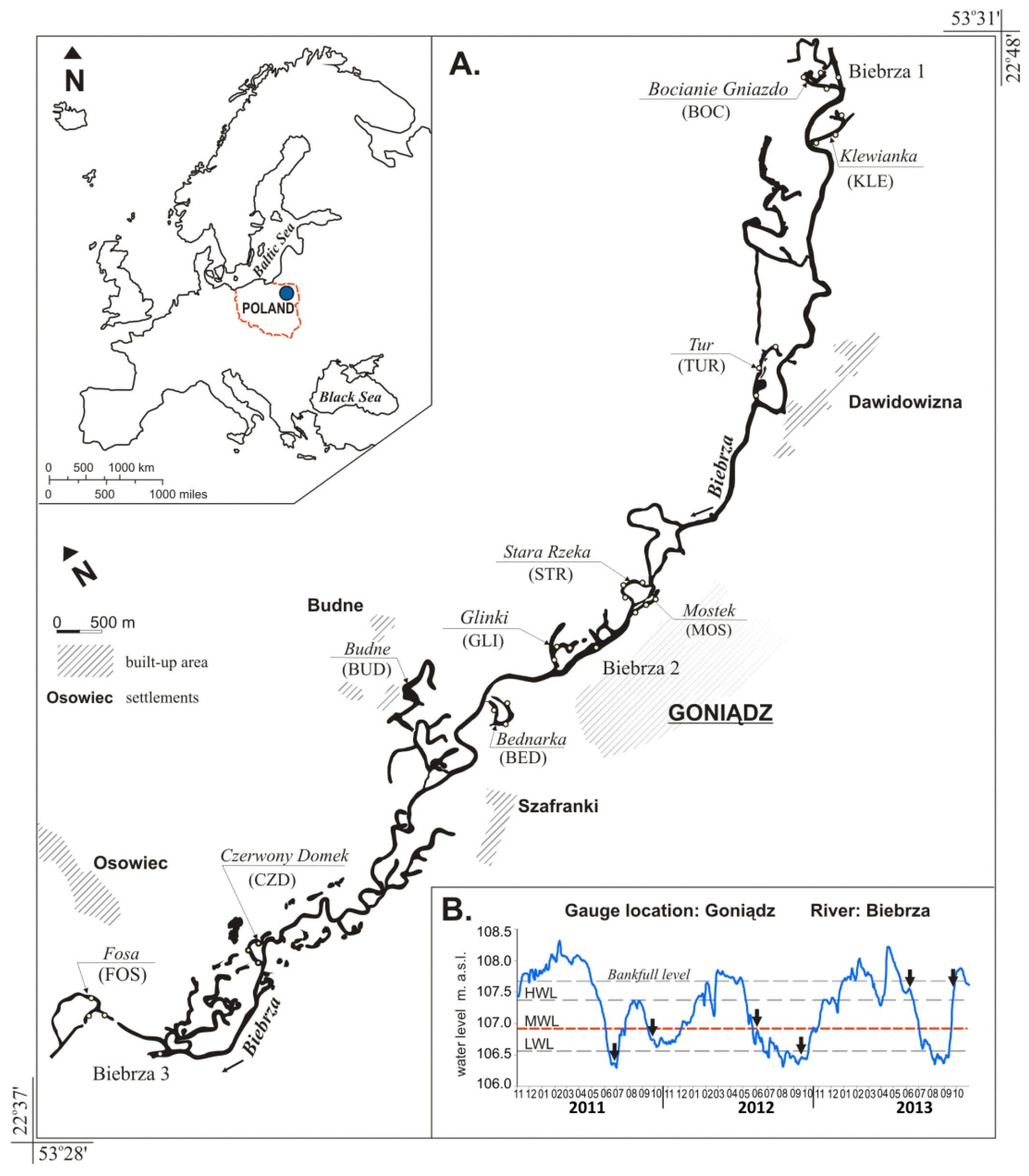
Article

Environmental Factors Structuring Fish Communities in Floodplain Lakes of the Undisturbed System of the Biebrza River

1
Department of Water Resources, Climatology and Environmental Management, University of Warmia and Mazury in Olsztyn, Plac Łódzki 2, Olsztyn 10-719, Poland
2
Department of Lake and River Fisheries, University of Warmia and Mazury in Olsztyn, Oczapowskiego str. 5, Olsztyn 10-718, Poland
3
Department of Hydrobiology, University of Kazimierz Wielki in Bydgoszcz, Jana Karola Chodkiewicza 30, Bydgoszcz 85-064, Poland
4
Department of Water Protection Engineering, University of Warmia and Mazury in Olsztyn, Prawochenskiego str. 1, Olsztyn 10-719, Poland
5
Department of Hydrobiology, Institute of Biology, University of Białystok, Ciołkowskiego 1J, Białystok 15-245, Poland
6
Department of Microbiology, University of Warmia and Mazury in Olsztyn, Oczapowskiego str. 5, Olsztyn 10-719, Poland
7
Division of Hydrology and Water Resources, Warsaw University of Life Sciences, Nowoursynowska str. 159, Warszawa 02-776, Poland
*
Author to whom correspondence should be addressed.
Water 2016, 8(4), 146; https://doi.org/10.3390/w8040146
Submission received: 27 January 2016 / Revised: 29 March 2016 / Accepted: 31 March 2016 / Published: 12 April 2016

Abstract

:
We evaluated the influence of habitat connectivity and local environmental factors on the distribution and abundance of functional fish groups in 10 floodplain lakes in the Biebrza River, northeastern Poland. Fish were sampled by electrofishing, and 15 physico-chemical parameters were recorded at three sampling sites at each lake in the period of 2011–2013. A total of 18,399 specimens, belonging to 23 species and six families, were captured. The relationships between environmental factors and fish communities were explored with the use of canonical correspondence analysis (CCA). Sampling sites were grouped based on fish communities using a hierarchical cluster analysis (HCA). Along a lateral connectivity gradient from lotic to lentic habitats (parapotamic–plesiopotamic–paleopotamic), the proportions of rheophilic species were determined as 10:5:1, whereas the proportion of limnophilic species was determined as 1:2:5. The predominant species were the roach (Rutilus rutilus), and pike (Esox lucius) in parapotamic lakes, rudd (Scardinius erythropthalmus) and pike in plesiopotamic lakes, and sunbleak (Leucaspius delineates) and Prussian carp (Carassius auratus gibelio) in paleopotamic lakes. The findings indicated that the composition and abundance of fish communities are determined by lake isolation gradient, physico-chemical parameters and water stage. Although intact riverine ecosystems may promote fish biodiversity, our findings suggest that lateral connectivity between the main channel and floodplain lakes is of utmost importance. Thus, the conservation of fish biodiversity requires the preservation of this connectivity.

1. Introduction

Natural river floodplains consist of complex habitats differing in hydrological connectivity, which affects fish community dynamics [1,2,3]. In the temperate climate zone, large undisturbed floodplains have often been disrupted by channel regulation that exerted direct and indirect effects on habitat heterogeneity, successional trajectories and, ultimately, the ecological integrity of rivers [4,5].
The functional feature of intact alluvial floodplains of meandering rivers is a mosaic of lotic and lentic ecosystems, including the river and its side channels, tributary streams and cut-off channels. Due to the variation in the connectivity, laterally across the floodplain, a distinct zonation of the habitats has been widely reported both for tropical [6,7,8] and temperate rivers [9,10]. Differences in the connection of floodplain lakes with the river channel determine the availability of nutrients and the degree to which processes such as primary productivity and decomposition are controlled by the river [11,12,13]. Floodplain ecosystems connected to the river are particularly open to exchange of matter with the river which leads to higher concentrations of macroelements, while ecosystems isolated from the nearby river for most of the year acquire a lentic character that promotes autogenic, mainly organic, matter cycling. An increased flow rate throughout bi-connected water bodies is beneficial to organisms in that it transports food, oxygen, nutrients, and particulate and dissolved organic matter [14,15].
The hydrological integration between river and cut-off channels is a significant habitat parameter for species that require different aquatic microhabitats in the course of their life cycle, e.g., certain species of fish [4,16,17,18]. Fish communities in European lowland riverine ecosystems are composed of rheophilic (require flowing water to spawn), eurytopic (habitat generalists) and limnophilic (found in stagnant and strongly vegetated floodplain water bodies) fish species guilds [4,19,20] that contribute to the overall high species diversity [4]. For example, the ide Leuciscus idus requires flowing water habitats, whereas the crucian carp Carassius carassius needs a single stagnant floodplain lake that exists over a long period.
Floodplain lakes are ecosystems with diverse fish species adapted to periods of low and high water stages (flood-pulse), which affect any wetland water quality parameters [11,21,22,23]. Higher water stages promote greater nutrient availability, aquatic primary production, allochthonous inputs, and secondary production, which are especially beneficial for early life stages of fish in floodplain habitats. In contrast, low-water conditions lead to the contraction of marginal aquatic habitats, decay of aquatic macrophytes, and higher densities of aquatic organisms, including phytoplankton and zooplankton in floodplain water bodies [24]. During low water periods, non-flowing ecosystems have been recognized as having limited conditions for light penetration and thereby limited photosynthesis. In turn, summer oxygen deficits are attributed to shading by emergent and floating vegetation, high biological oxygen demand and limited aeration [25].
The natural hydrological regime is one of the key drivers of ichthyofauna development [2,8]. Floodplain lakes typically serve as nursery for young fish whereas adults live in the main channel or connected side arms [4,18]. Welcomme and Halls [8] observed that extensive flooding increased the area available for spawning sites and provided fish with more food and better shelter opportunities, whereas the duration of the flood influenced the time during which fish could grow and find shelter from predators. In several studies, fish migrated to floodplain water bodies, in particular to lentic habitats, in search of refuge during floods [26,27,28]. When water levels drop, fish either migrate back to the river and become a source of food for resident piscivores or remain in isolated floodplain water bodies [2,6,29].
An increase in the reductions in landscape connectivity, ecological functioning and ecosystem biodiversity has driven initiatives to improve the ecological status of rivers, e.g., the European Union Water Framework Directive (2000/60/EEC) [30], and to protect biological diversity, e.g., the Habitats Directive (92/43/EEC) [31] and Agenda 21 of the Rio Convention and the Convention on Biological Diversity. According to Welcomme et al. [20], fish environmental guilds could be used as a tool for assessing the ecological status of rivers. Further, the knowledge of differences in the responses of functional fish groups to environmental factors is useful for predicting the effects of future environmental manipulations (e.g. changes in hydrology and connectivity) on fish communities in various aquatic systems. Achieving good ecological status by promoting fish abundance and diversity involves the creation of habitats that are functionally similar to natural lowland river-floodplain ecosystems. Nevertheless, this approach requires a relevant reference area to test whether environmental parameters are affecting the qualitative and quantitative structure of hydrobionts. The Biebrza river provides an opportunity to realize this test as it is an undisturbed system presenting variable levels of lateral connectivity with sequential shift in fish community composition from rheophilic to eurytopic to limnophilic fish species guilds, as it was reported ca. 30 years ago by Witkowski [14,32]. Moreover, unlike many rivers in Europe, the floodplain lakes in the middle and lower section of the Biebrza River have not been disturbed by hydraulic structures, excessive nutrients or sediments introduced by runoffs from the surrounding farmland.
The aim of this study was to determine whether lateral connectivity and environmental parameters are influencing the qualitative and quantitative structure of fish communities in floodplain lakes. For this purpose, we sampled 10 natural floodplain lakes and the river channel in the middle section of the Biebrza River, (NE Poland) depending on their connectivity and habitat diversity.

2. Materials and Methods

2.1. Study Area and Sampling Sites

Biebrza is a medium-sized low-gradient river in NE Poland. Its catchment occupies a total area of 7057 km2, and the floodplain covers an area of 1950 km2. The Biebrza River Valley features the Upper, Middle and Lower basins, which have been classified based on differences in their geomorphologic structure [33,34]. The Middle Basin is approximately 33 km long and spreads along the floodplain between the villages of Sztabin and Osowiec. The river intersects boggy meadows and marshes. Throughout its course, the river forms a large number of old riverbeds and floodplain water bodies in different stages of succession. The catchment was extensively drained in the mid-1970s, but Biebrza's floodplain escaped alteration. In the middle section its natural landscape and flood-pulse pattern have been nearly entirely preserved [24,33]. Excluding a 10-km-long section, the river is part of the Biebrza National Park, and it is protected under the Ramsar Convention.
The hydrological regime in Biebrza’s middle course has a natural pattern. Mean annual amplitude of water levels is within the range of 264 cm [34]. The river is characterized by a snowy, distinct flood-pulse regime, with long-term spring floods. During spring floods, the narrow river swells to form a vast shallow impoundment, locally up to 1 km wide, that lasts for several months. The average multiannual flow (1984–2013) measured at a gauge located in Osowiec was 22.78 m3·s−1 (Qmin = 3.08 m3·s−1, Qmax = 360.00 m3·s−1). During our study (2011–2013), frequency of high water stages (HWL) was higher in comparison to the multiannual period of 1984–2010 [24]. Inundation periods in 2011, 2012, and 2013, calculated as the percentage of days in a year when water table exceeded bankfull level (BL = 107.70 m above sea level), were 42%, 35% and 48%, respectively (Figure 1B). Stages below mean low water level (MLW) in 2011 lasted 8% of the year, in 2012 as much as 23% while in 2013 as much as 19%.

2.2. Environmental Description of Study Sites

Sampling sites were located in 10 floodplain lakes and the main river channel of the Biebrza River (Figure 1). The lakes were chosen based on a wide range of lake morphometric characteristics (e.g., area and connectivity to the river channel) as well as hydrological and water quality parameters. Lakes with passable inlets and outlets may have a different hydrologic cycle than lakes without inlets or outlets, which facilitates fish movement. The analysed water bodies were classified into four types with different hydrological connectivity and water retention patterns according to the typology proposed by Amoros and Roux [1] (Figure 1):
Eupotamic—the main river channel (Biebrza 1 to 3);
Parapotamic—lotic side-channels (by-passes) with flowing water: Stara Rzeka (STR), Mostek (MOS) and Czerwony Domek (CZD);
Plesiopotamic—semi-lotic abandoned meanders, permanently connected with the river by a downstream arm: Bocianie Gniazdo (BOC), Klewianka (KLE), Tur (TUR) and Glinki (GLI);
Paleopotamic—lentic side channels and depressions filled with stagnant water and isolated from the river unless flooded: Budne (BUD), Bednarka (BED) and Fosa (FOS).
Parapotamic lakes belong to the youngest water bodies that are permanently bi-connected to the river channel. Those lakes form natural by-pass channels, with an area of 0.62–3.31 ha, maximum depths of 1.4–3.4 m and a water table with a relatively low macrophyte cover (15%–25%) with a predominance of the Myriophyllo-Nupharetum plant association (Table 1). Lake banks were occupied by natural marshes with a narrow belt of plants characteristic of Scirpo-Phragmitetum communities and Phragmites australis (Cav.)Trin. ex Steud. or Acorus calamus L. The group of lakes was characterized by medium to coarse-grain mineral substrates (i.e., sand or gravel), depending on the scouring flow velocity.
Plesiopotamic lakes, identified along the permanent single-arm surface connection with the river channel, have various morphological conditions. In the downstream section close to the river junction, they were characterized by fine mineral sediments (clay or silt) with moderate organic content that resulted mainly from backflow inputs and deposits combined with in situ in situ production and deposition of organic matter. The deepest points (4.1–5.5 m) of the lakes were situated in the center of the water body under concaved banks. The most remote lake locations were shallow (up to 1 m) and overgrown mainly with Nuphar lutea L., Potamogeton lucens L., and Nymphaea alba L. In upstream sections, pleustonic species (Spirodela polyrhiza L. Schleid., Lemna minor L., and Lemna trisulca L.) covered more than 70% of lake area.
Paleopotamic water bodies are the oldest floodplain lakes with a maximum depth of 1.5–2 m and abundance of emerged and submerged macrophytes, the main contributors to eutrophication. The lakes were covered by the water soldier Stratiotes aloides L., frogbit Hydrocharis morsus-ranae L., yellow water-lily N. lutea Please define. and sporadically white water-lily N. alba. Define. Submerged vegetation was abundant in Budne where Ceratophyllum demersum L. covered more than 75% of the lake’s area. Lake sediments were composed of autogenic organic matter. The only lake that was significantly altered by human activity was Fosa which was transformed into a moat surrounding the concrete casemates of the Osowiec fortress in the 19th century. Unlike other floodplain lakes, Fosa is permanently isolated from the river, even at the bankfull stage. The moat is 5.6 m deep and heavily overgrown with plants of the Nupharo-Nymphaeetum albae community in the southern part and the Hydrocharitetum morsus-ranae assemblage in the north. A thick layer of mud covers the lake’s bottom. Morphometric details of the studied floodplain lakes are given in Table 1.

2.3. Environmental Data

Water for chemical analyses was sampled twice a year, in June and September of each year of the study (2011–2013), from 10 floodplain lakes (30 sampling points) and the Biebrza River (3 sampling points), simultaneously with fish catches. In situ measurements of dissolved oxygen (DO), pH, electrolytic conductivity (EC), total dissolved solids (TDS) and chlorophyll-a levels were performed using the YSI 6600R2™ calibrated multiprobe (Yellow Springs, OH, USA). Water transparency was measured with Secchi disc (20 cm in diameter). The concentrations of phosphates, nitrates, nitrites and ammonium ions were determined in a laboratory with the use of standard analytical methods [35]. Total organic carbon (TOC) levels were determined in unfiltered samples. Dissolved organic carbon (DOC) was quantified after the samples had been passed through nitrocellulose membrane filters with a pore size of 0.45 µm (Millipore). TOC and DOC analyses were conducted by high-temperature combustion (HTC) (Shimadzu TOC 5000 analyzer, Tokyo, Japan), and performed according to the protocol described by Dunalska et al. [36].
Lake morphometric variables were estimated once and referred to mean water level. Mean depth measurements of each lake were determined by traveling zigzag patterns across each lake with a portable depth finder (echosonde Humminbird) attached to a GPS receiver (TOPCON) and recorded every 15 s. Maximum depth of each lake was determined from these measurements. In this study, we employed three water stage categories of high (HW), mean (MW) and low (LW) water based on the data provided by the Institute of Meteorology and Water Management in Poland (IMGW) for the Biebrza River at Osowiec. Furthermore, in order to develop stream flow hydrographs for use in flood extend estimation, continuously recording water depth logger (MiniDiver, Van Essen Instruments B.V., Delft, The Netherlands) was installed in the Biebrza River channel at the town of Goniądz. The logger was set to take measurements at approximately 15 min intervals. The measurement protocol was described by Grabowska et al. [24].

2.4. Fish Sampling

Fish were sampled by the electrofishing method [37]. Fish were caught from a boat along three 80–200 m transects (upstream arm, downstream arm and the middle section) along each of the 10 floodplain lakes (30 sampling sites) and from the river channel (3 sampling sites) in accordance with standard PL-EN 14011 [38] (Figure 1). Single-pass electrofishing was performed along one bank, in a distance of 2–3 m from the bank, with repeated immersion of anode for 20–30 s. Total time of a catch at one site lasted ~20 min.
Stunned fish were collected with nets and placed in tanks with aerators. Tank water had to be aerated to keep the catch alive and to minimize damage associated with handling and holding. Fish were identified to species level, counted and measured. Total fish length was recorded in mm, and fish weight in g. Large and medium-sized specimens were weighed individually. The weights of small individuals were calculated based on the length-weight ratios determined from the first sampling period. Immediately after the measurements, all fish were released into a calm area near the capture site. For each species in every catch, abundance was determined as the number of fish per ha based on individual fish counts, and biomass was calculated based on weight extrapolations for the estimated area of the electrofishing transect [14]. However, the last two parameters should be considered as rough estimations and used for comparative purposes.

2.5. Data Analysis

Fish biodiversity, taxonomic guilds and functional guilds were examined. Quantitative data were analyzed and converted to biocenotic indices: constancy of occurrence and dominance according to the formulas used by Obolewski et al. [39]. The constancy of occurrence (C, %) defines the occurrence of a given species within a single biocensosis. It has been calculated according to the formula C = 100 na/Nn, where: na-number of sites where the species was noted; and Nn-total number of sites. The values of constancy of occurrence allowed for the following classification of consecutive species: euconstants > 75.00%; constants 50.01%–75.00%; subconstants 30.01%–50.00%; accesoric taxa 15.00%–30.00% and accidental taxa < 15.00%. Dominance index (D, %) was calculated according to the following formula: D = 100 ni/N, where: ni—number of specimens of species “I” in the sample, N-number of all specimens in the sample. The following levels of dominance have been applied: eudominants >10.00%; dominants 5.10%–10.00%; subdominants 2.10%–5.00%; and recedents ≤ 2.00%. Additionally, the Shannon–Wiener’s diversity (H′) and the Pielou’s evenness (J′) indices were calculated. Biodiversity metrics were calculated using the diversity modules available in the PAST ver. 3.02TM software [40]. Significant differences in density and biomass between functional groups of floodplain lakes as well as between seasons and water levels were determined by one-way and two-way ANOVA followed by Duncan's multiple range test at p ≤ 0.05. All of these calculations were performed in Statistica 10.0 PL (StatSoft, Tulsa, OK, USA, 2011).
Canonical correspondence analysis (CCA) was used to determine the extent to which environmental variables (including water quality, lateral hydrological connectivity and water levels) were responsible for variations in the taxonomic composition of fish between lakes. Unimodal ordination was applied because the gradient length along axis 1 in detrended canonical analysis (DCA) exceeded 3.0 SD turnover units. Linear ordination was used in the remaining cases [41]. We used the forward selection procedure to determine the extent to which environmental and community variables explained fish community variations. Conditional effects, which indicate the order of inclusion, and amounts of variance explained in addition to previously added variables, of each environmental variable in the model were calculated and tested for significance using Monte Carlo permutation tests (999 random permutations). Only environmental variables explaining significant amounts of variance (p ≤ 0.05) were retained in the model and tested for significance. We also determined and report the variance attributed to each variable independent of other environmental variables (marginal effects). Fish and environmental data were log(x + 1) transformed before CCA to reduce the influence of outliers on the results. The relationships between species and the selected environmental variables were examined in CCA ordination plots based on species scores. Since rare species may have strong influence in ordinations, the analyses were also performed on reduced data sets, excluding taxa with dominace index (D) ≤ 2% (recedent species). All ordinations were performed in CANOCO version 4.5 [41].
In hierarchical cluster analysis (HCA), objects are classified based on their similarity to other objects in the cluster based on a predetermined selection criterion. HCA was applied to investigate the grouping of the sampling sites. The Euclidean distances were used as a measure of similarity between sampling sites while Ward’s error sum of squares hierarchical clustering method were applied to minimize the increase in within-group variance. The spatial variability of fish ecological guilds was determined from HCA using the linkage distance, reported as Dlink/Dmax. The quotient is then multiplied by 100 as a way to standardize the linkage distance represented on the Y-axis.

3. Results

3.1. Water Quality

The surveyed floodplain lakes differed significantly in size, depth, range of water level fluctuations and the gradient of lateral connectivity with the adjacent river channel, which produced a dataset with a broad range of physicochemical parameters (Table 2). Water mineralization was average with mean electrolytic conductivity of 542 ± 110 μS·cm−1. Lower values in the range represented lotic habitats, and higher values were associated with lentic lakes. The pH of water was slightly basic (pH 7.77), and it decreased significantly when water levels were high, in particular in parapotamic water bodies (r = −0.62; p = 0.001). Floodplain lakes were generally abundant in organic matter with an average TOC content estimated at 12.59 ± 4.64 mg·L−1 and a significant share of DOC (10.50 ± 3.18 mg·L−1). In addition to autogenic organic matter, the accumulation of humic compounds and decomposed organic matter from adjacent peatlands significantly contributed to an increase in DOC in isolated lakes (48.92 ± 21.50 mg·L−1). High concentrations of suspended solids in paleopotamic habitats reduced water transparency to 1.1 ± 0.3 m. In para- and plesiopotamic lakes, Secchi disc visibility was significantly higher at 1.5 ± 0.6 and 2.0 ± 0.9 m, respectively. Overall productivity of the ecosystems was related to the concentrations of chlorophyll-a, which, in paleopotamic and plesipotamic lakes, was twice as much (~17.50 μg·L−1) as in parapotamic habitats (8.04 ± 4.03 μg·L−1) or in the river (7.31 ± 0.80 μg·L−1).
The mean concentrations of total phosphorus in the floodplain lakes were determined at 0.35 mg·L−1 and no significant differences were observed between the evaluated water bodies. Phosphate phosphorus levels were higher in parapotamic lakes (0.12 ± 0.05 mg·L−1; post-hoc Duncan’s test, ANOVA; p ≤ 0.05) than in paleopotamic lakes (0.07 ± 0.04 mg L−1). Total nitrogen concentrations increased along the isolation gradient from 1.07 mg·L−1 in parapotamic lakes to 1.39 mg·L−1 in paleopotamic lakes. The content of total inorganic nitrogen (TIN= NO2–N + NO3–N + NH4–N) was similar among the studied floodplain lakes (0.34–1.55 mg·L−1), but the contribution of each N-form differed significantly relative to water retention time: ammonium nitrogen was the predominant form in stagnant water of paleopotamic habitats (69%), whereas nitrate nitrogen in flowing water in parapotamic water bodies (62%).
The correlations between TP and TN concentrations vs. water levels varied across the examined lakes (correlations are not shown in the tables). TP values were positively correlated with water levels in plesiopotamic (r = 0.41, p = 0.02) and parapotamic lakes (r = 0.45, p = 0.02), but no such correlations were observed in paleopotamic lakes. Unlike TP, the rise in water levels significantly reduced TN concentrations in all lake types (r = −0.58; p = 0.001). DO was significantly higher and more stable in parapotamic lakes (7.45–1.54 mg·L−1; post-hoc Duncan’s test, ANOVA; p ≤ 0.05) than in plesiopotamic (6.51–2.12 mg·L−1) and paleopotamic habitats (6.13–2.31 mg·L−1).

3.2. Fish Assemblages

A total of 18,399 fish from 23 species belonging to 6 families were sampled but the number of specimens varied significantly across species. Cyprinidae was the most abundant and diverse family represented by 15 species (Table 3). The family Cobitidae was represented by three species, Percidae by two species and the families Esocidae, Siluridae and Gadidae by one species each. The roach R. rutilus define and the define rudd S. erythrophthalmus were eudominant species that accounted for 36% and 12% of all captured specimens, respectively. The pike E. lucius, bitterling Rhodeus sericeus amarus, silver bream Blicca bjoerkna and sunbleak L. delineates were dominants. Other species, including the perch Perca fluviatilis, Prussian carp C. auratus gibelio, tench Tinca tinca, bream Abramis brama and bleak Alburnus alburnus, were less abundant (3%–5%), but they had a stable share of the assemblage.
Among eurytopic fish, the roach R. rutilus and the pike E. lucius were encountered most frequently (euconstants found in >75% of the sites). Other eurytopic constant species (50% < occurrence < 75%) were the perch and silver bream, as well as the rudd, bitterling and tench in the group of limnophilic fish. Rheophilic species were far less abundant and amounted to 2.3% in plesiopotamic, 3.1% in paleopotamic and 8.2% in parapotamic water bodies.
Amount of rheophils in lotic habitats was 50% lower than that in the Biebrza river channel. Along the lateral connectivity gradient of parapotamic–plesiopotamic–paleopotamic lakes, the proportions of rheophilic species were determined at 10:5:1, and limnophilic species at 1:2:5.
Five out of the 23 identified species have been placed on the IUCN Red List of Threatened Species, and four are listed in Annex II to the EU Habitat Directive (92/43/EEC). They include three rheophilic species: the asp Aspius aspius, spined loach Cobitis taenia, and stone loach Barbatula barbatula and two limnophylic taxa: weatherfish Misgurnus fossilis and the bitterling R. sericeus amarus. The above species had less than 2.5% share of the fish assemblage, excluding the bitterling, which was a dominant and frequently observed species. The Prussian carp was the only non-native species identified in the study. However, the study of van Damme et al. [42] showed evidence of the bitterling as non-native for the Polish watercourses.
As many as six species colonizing the Biebrza floodplain lakes were piscivores (Table 3 and Table 4) that accounted for nearly 12.4% of all specimens. Pike represented 60% and perch 35.7% of the identified piscivores. Other predatory species, such as the wels catfish Silurus glanis, burbot Lota lota, and the chub Squalius cephalus, were less populous.

3.3. Fish Response to Habitats along the Connectivity Gradient

The composition of fish species in parapotamic, plesiopotamic, and paleopotamic floodplain lakes relative to the location of the sampling site is presented in Table 4.
Parapotamic lakes (lotic side-channels) were inhabited by 21 of the 23 identified fish species, and the only missing taxa were the Prussian carp and the stone loach (Appendix A). Mean fish density in the lakes amounted to 1995 specimens per ha, which was lower in comparison with other types of lakes, and accounted for 23.9% of captured fish (Table 4). Fish species contribution decreased between upstream arms (9.1%) and downstream arms (6.5%). The biodiversity index of parapotamic habitats was determined at H′ = 2.45, and species evenness at J = 0.79. Fish biomass in lakes of that type amounted to 78.4 kg·ha−1, which constitutes ~34% of total fish biomass, but it was the highest near the downstream connections with the river (85.1 kg ha−1).
Active exchange of water in habitats provides similar conditions for ichthyofauna to those noted in the Biebrza River. Eurytops accounted for 71%, limnophils for 21%, and rheophils for only 8% of the species in parapotamic lakes. In the group of parapotamic lakes, the roach and pike were eudominants, whereas the rudd, perch and silver bream were dominants (Appendix A). No rheophilic species were eudominants or dominants in the studied group of water bodies. Among rheophilic species, only L. idus was a subdominant.
The ichthyofauna in plesiopotamic lakes was represented by all of the 23 identified fish species. As many as 19 species were found in both upstream and middle arms, whereas 18 taxa were observed near the connection with the river channel. The diversified habitats along plesiopotamic lakes showed decreased water exchange, aeration and depth gradients, and they were colonized by 41% of captured fish and characterized by the highest biodiversity index (H′ = 2.51). One-side connected lakes showed mean fish density determined at 2687 specimens ha−1. Fish biomass in plesiopotamic lakes amounted to 85 kg·ha−1 and was the highest (36.5% of total biomass) among the studied lakes types. Although eurytops prevailed in the species composition (72.3%), an increase in limnophils by 5%, when compared to parapotamic lakes, has been noted. The number of limnophilic taxa (rudd, bitterling and tench) increased with a distance from the river channel. Eudominants in the plesiopotamic lakes were represented by roach, rudd, and pike, while dominants by silver bream bitterling, and perch. Due to stagnant water, no psammophils were identified, but the presence of ostracophils (bitterling) and litho-pelagophils (burbot) was noted in the downstream section in the vicinity of the river connection.
Fish assemblages in paleopotamic lakes were represented by the lowest number of species (17) and, consequently, the lowest biodiversity index (H’ = 2.23) in comparison with the lakes connected to the river (Table 4). Simultaneously, isolated water bodies were characterized by the highest evenness index (J’) of 0.82. A clear increase in the share of limnophilic species (up to 63.1%) could be attributed to lakes' isolation from the river channel. The roach was the eudominant species with the highest D index. Paleopotamic lakes provided particularly supportive habitats for sunbleak and Prussian carp (Appendix A). Among dominant species were pike, rudd, bitterling and tench. The number of specimens captured was almost 50% higher than that caught in bi-connected side-channels. Fish density reached 2936 specimens·ha−1. Despite high fish abundance, fish biomass in isolated habitats was lower (70 kg·ha−1, ~29% of total) than in lakes connected to the river channel.

3.4. Influence of Environmental Factors on Fish Abundance and Diversity

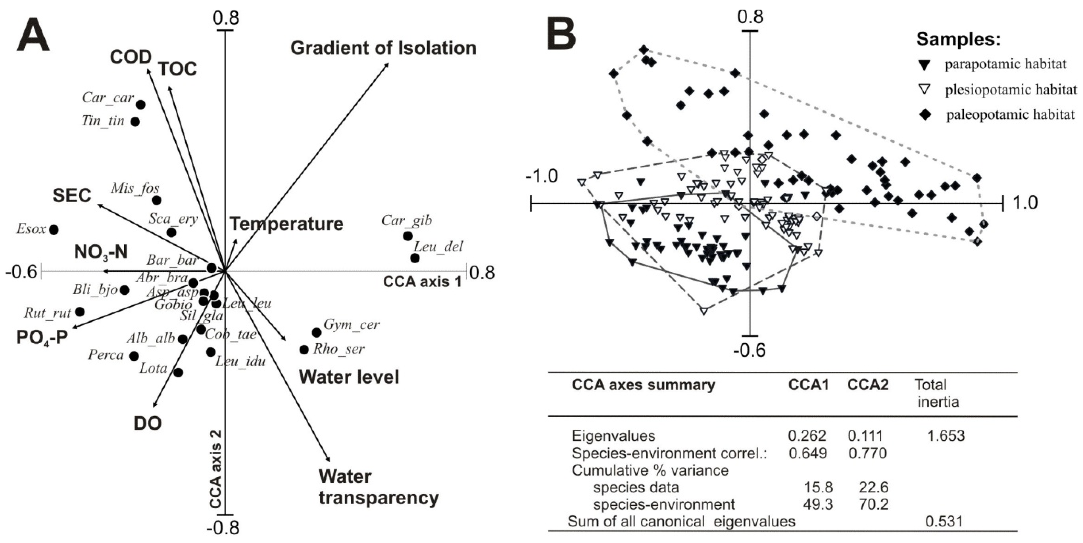
Three types of floodplain lakes (parapotamic, plesiopotamic, and paleopotamic), classified based on hydrological connectivity, differed significantly in physicochemical parameters of water and fish responses to varied habitat conditions. The canonical correspondence analysis (CCA) biplot (Figure 2A) demonstrates the correlations between environmental factors as lateral connectivity, water level, water quality parameters and the abundance of fish fauna in the studied floodplain lakes. The results of the CCA (Figure 2A) showed that eigenvalues of the first (λCC1 = 26.2%) and second (λCC2 = 11.1%) CCA axes accounted for 70.2% of the cumulative variation in the environmental data. The final model accounted for 22.6% of the total variance in fish composition and all canonical axes were significant (Monte Carlo test, p = 0.002).
Ten out of 17 input variables were retained as significant contributors to the CCA model (Table 5). The non-retained seven were redundant or did not increase the significance. The hydrological set of variables (including isolation gradient and water-level variability) accounted for λ1 = 18% of the species variability, while retained physical and chemical variables, including SEC, DO, CODCr, temperature and TOC explained in total 36%. Trophic variables (NO3–N and PO4–P) explained 11% of the variability.
The ordination space of factors CCA1 and CCA2 were clearly distinguished by environmental variables and fish species composition, confirming previous analyses. The first factor (CCA1) showed a gradient from highly eutrophicated lentic sites to less eutrophicated parapotamic sites (Figure 2A). It correlated negatively with NO3–N, SEC and PO4–P while positively with water level. Organic matter content, expressed by CODCr and TOC, was positively correlated, whereas DO and water transparency were negatively correlated with CCA2 (20.9% of the variance). Significant variance explained by the lake isolation gradient (λ1 = 15%) was confirmed by three clusters of samples comprising parapotamic, plesiopotamic, and paleopotamic habitats (Figure 2B). Lakes situated near the river with transparent and well-aerated waters were characterized by a predominance of rheophils, including the burbot, ide, wels catfish, asp, gudgeon, bleak and dace. Stagnant water habitats attracted mostly the rudd, Prussian carp, crucian carp, tench and weatherfish.
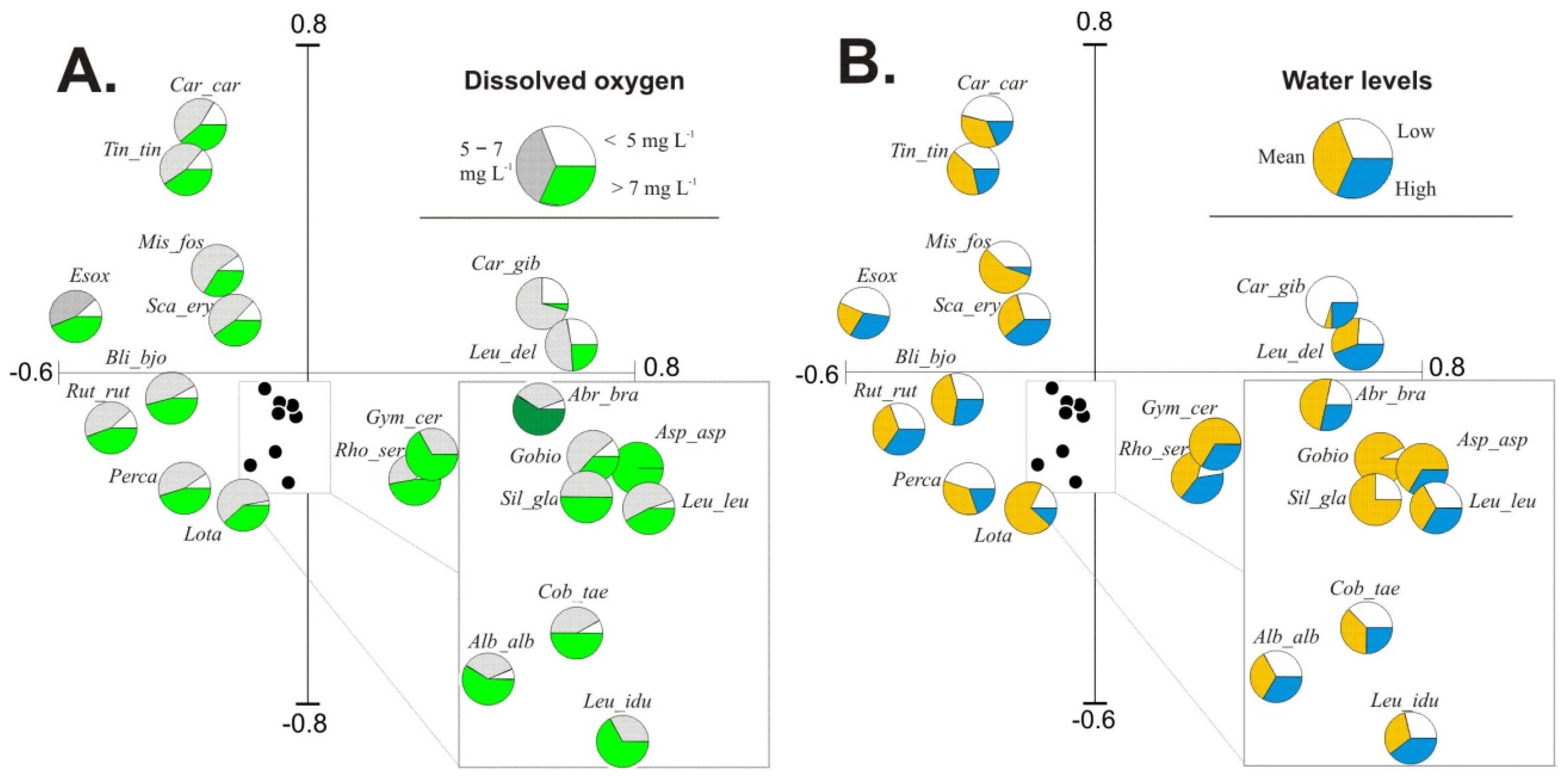
Forward selection revealed that in the group of input environmental variables, hydrochemical parameters were significant in explaining fish occurrence and abundance patterns in the studied floodplain lakes. White bream and pike were related to habitats with higher NO3–N concentrations and lower water levels. Limnophilic species (crucian carp and tench) preferred habitats with higher COD and TOC and lower DO content, which are characteristic of lakes isolated from the river. In contrast, rheophilic (burbot) and eurytopic (perch and bleak) species preferred transparent and well aerated water. The availability of dissolved oxygen (DO) is the key contributor to fish yield in lakes. The highest share of fish specimens in water containing > 7 mg DO L−1 confirmed distinct preferences of fish for inhabiting water bodies supplied with river water; this is presented in the form of species pies charts in Figure 3A. The diagrams of pies charts based on water levels, as presented in Figure 3B, showed that water stage is a significant factor that changes the quantitative structure of fish species in floodplain lakes.
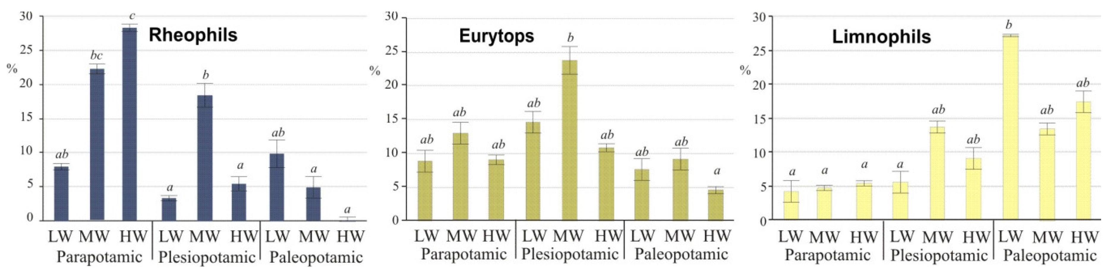
As typical inhabitants of isolated lakes, limnophils differed significantly (ANOVA, post-hoc Duncan’s test, p ≤ 0.05) from other guilds during low water stages (Figure 4). In the group of rheophilic species, the chub predominated at low water (50% of specimens), mainly in lakes of high water exchange. High water (potamophase) did not contribute to an increase in species abundance. Only two species, the ide and asp, adapted to higher water stages, and their share during that period reached 65% and 60%, respectively (Figure 3A). The above taxa contributed the group of rheophils that were characterized by significant differences (ANOVA, post-hoc Duncan’s test, p ≤ 0.05) during high water. Eurytops were more opportunistic and had no water stage preferences, but their share in lentic lakes decreased during floods (Figure 4).
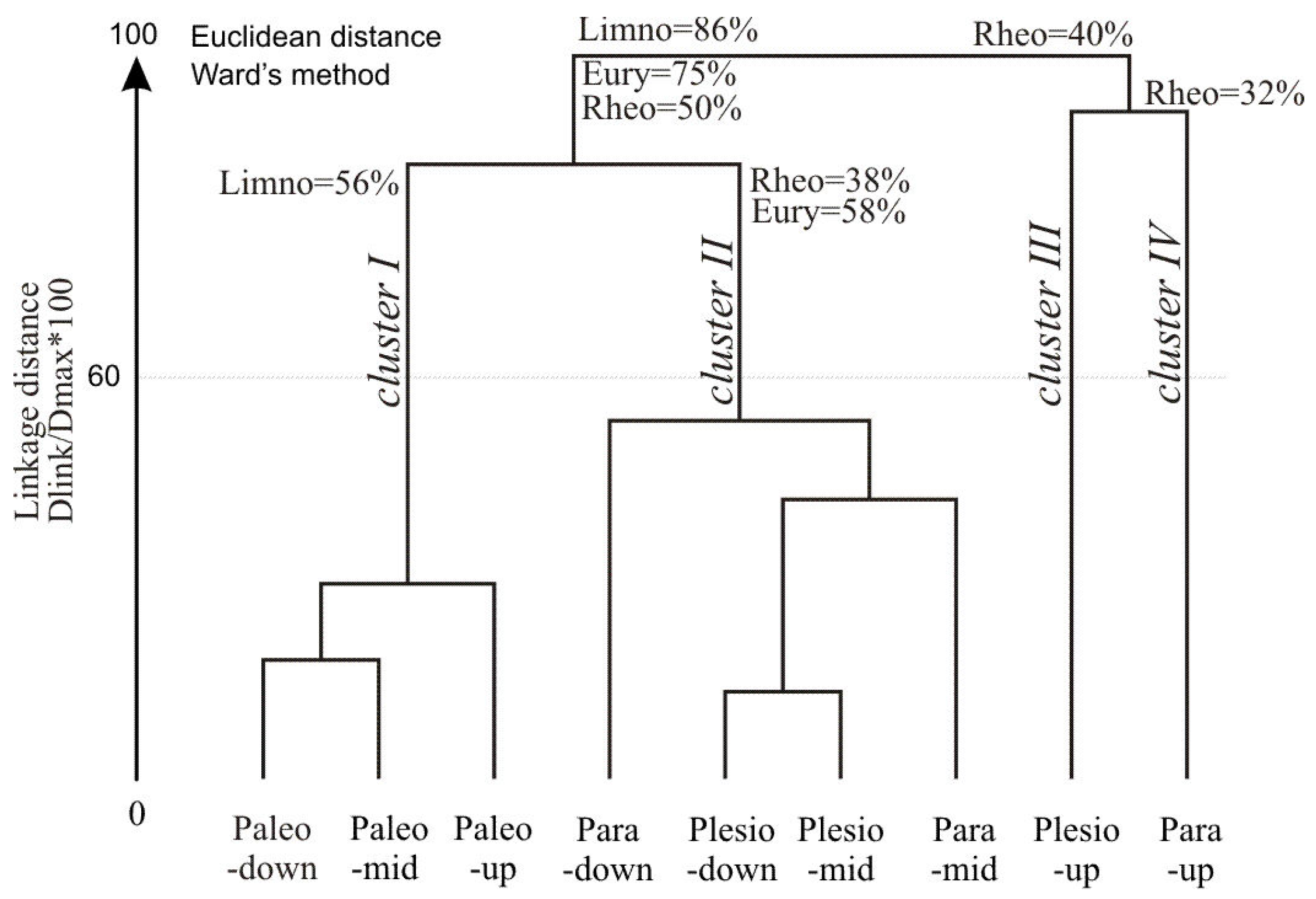
Hierarchical cluster analysis (HCA) performed on the percentage of species abundance in nine lake-sites produced four clusters of objects (Figure 5). Cluster I covered lentic sites with a high percentage of limnophils (56%) and complementary species, mainly eurytops. The cluster comprised the predominant species in lentic habitats: the Prussian carp, crucian carp, sunbleak, bitterling and weatherfish. Cluster II was characterized by a significant share (58%) of eurytopic species. Clusters III and IV had a similar share of rheophils (40% in total), including the asp, gudgeon, chub, dace and spine loach.

4. Discussion

The present study showed that variations in fish abundance and community structure were related to environmental variables in floodplain lakes of the Middle Basin of the Biebrza River. Furthermore, the diversity of environmental conditions in the lakes produced distinctive fish guilds. Major environmental gradients related to the structuring of fish communities involved degree of isolation from the river, water transparency, SEC, DO, COD, temperature and water levels, whereas nutrients such as PO4–P, NO3–N and TOC played a minor role.
Lateral connectivity was found to be a key driver in shaping fish assemblage attributes in the studied floodplain lakes. It promotes fish migration, and thus species exchange, when the surface pathway is maintained between river channel and water ecosystems. Kwak [43] reported that the increase in lateral movement of fishes between the river channel and floodplain habitats is enhanced by the increasing river discharge. In the case of the Biebrza River, the fish colonization of isolated water bodies probably occurs annually in spring when frequency and duration of connection is greatest. Flood-pulse of water is an essential factor that determines nutrient cycling, which is consistent with the hypothesis postulated by, e.g., Amoros and Bornette [44] or Junk and Watzen [23]. The connection of lakes with the main river channel during periods of high water provides the input of well-aerated river water, which protects the lakes against severe oxygen deficits. It is a period of somewhat “deep breath”, which enables many organisms to survive in isolation, and may be crucial for maintaining their populations [15]. During low water periods, particularly in summer, the decreasing gradient of oxygen resources is the most distinct: from optimal aeration (ca. 7 mg DO·L−1) in parapotamic lakes towards paleopotamic lakes with significant DO deficits (<2 mg·L−1). For example, DO measurements performed in the summer of 2011 in vertical profiles of isolated lakes during a low water stage revealed a shortage of oxygen already 0.4 m below the water table. According to estimates, more than two-thirds of the water volume in isolated lakes could experience anaerobic conditions in summer (not shown in the figure drawing), which could have significant implications for fish populations in those ecosystems.
Lateral gradient of lake connectivity is directly related to fish densities, which increased from ca. 2000 in lotic to 3000 specimens·ha−1 in lentic habitats. Parapotamic lakes were inhabited by 24%, plesiopotamic by 41% and paleopotamic lakes by 35% of the evaluated fish population. Similar to the study of Winemiller et al. [15], we observed higher values of the biodiversity index (H′) in floodplain lakes than in the Biebrza River. In our study, H′ was higher in plesiopotamic lakes than in parapotamic and paleopotamic lakes. The evaluated lake types were arranged in the following sequence based on the values of H′: plesiopotamic > parapotamic > paleopotamic. The results of this study confirm the findings of Tockner et al. [21] or Guti [9] for the Danube, where the structure of ecological fish guilds changed from rheophilic to limnophilic and the diversity of fish species decreased in the lateral transect along with the increased distance from the main river channel and a decrease in hydrological connectivity. Along the lateral connectivity gradient of parapotamic–plesiopotamic–paleopotamic lakes, the proportions of rheophilic species were determined at 10:5:1, and limnophilic species-at 1:2:5. High species diversity in the analyzed floodplain lakes resulted from the co-occurrence of eurytopic, limnophilic and rheophilic guilds.
The ichthyofauna in the Biebrza floodplain lakes was most abundant in eurytops (59% of all specimens), that live under both lotic and lentic conditions. A wide range of microhabitats in semi-lotic lakes creates greater opportunities for eurytopic species, which are capable of living in varied habitats, than lotic or lentic environments. The predominant eurytopic species were the roach, pike, rudd, bream and bleak. Long-term isolation allows for a succession of the fish assemblage towards floodplain specialist limnophilic species [10]. Limnophilic species accounted for 37% of the evaluated fish guilds, where the Prussian carp was the eudominant, and the crucian carp, bitterling and tench were the dominants. The above species are tolerant of habitats with low oxygen resources and high organic matter content (e.g., Prussian carp) that are found in isolated water bodies. Limnophils abundance was highly correlated with water quality descriptors (COD, TOC, DOC, NH4–N and TN) characteristic of fertile and productive ecosystems. Other variables, including pH, DO, turbidity and macrophyte cover, also influenced fish assemblages inhabiting isolated water bodies as reported in temperate floodplains [15,17,45]. Adaptation to anoxic conditions of the floodplain specialists is often accompanied by poor competitive abilities and predation avoidance, resulting in low population densities and high mortalities in multispecies fish assemblages, as in crucian carp [46]. Thus, long-term isolated floodplain lakes in advanced successional stages with a tendency to temporary anoxia provide important refuge habitats for these species [45]. Advanced successional stages of such lakes provide most suitable habitats for still-water species and specialist species that have evolved physiological adaptations and strategies to survive hypoxic and anoxic conditions [10]. Accordingly, limnophilic fish are essential elements of the typical fish community of floodplain aquatic ecosystems and thus can serve as an indicator of their ecological integrity. We share the opinion of Welcomme et al [20] that isolated lakes are at least as important as the lakes with high rates of water exchange as fish habitats. Isolated lakes offer a rich array of habitat types at different stages of succession, and they are in direct need of statutory protection.
Our findings are consistent with the results of previous studies on fish assemblage metrics among floodplain lakes. In a study of fish assemblage structure among oxbow lakes of the Brazos River (Texas) species richness, diversity, and evenness were greatest in the connected oxbow lake [15]. Similarly, Galat et al [47], Miranda [12,45], and Petry et al [48] noted more species in oxbow lakes that are connected to the Mississippi, Missouri, and the Parana River (Brazil), respectively, than in lakes permanently separated from the river. They observed greater species richness in connected floodplain water bodies than in isolated water bodies. Also Dembkowski and Miranda [13], based on the monitoring of fish assemblages in two segments of an oxbow lake, one connected to and the other isolated from the Yazoo River, stated that greater species richness, diversity, and evenness were observed in the connected segment than isolated one.
Although the environmental variables play an initial role in structuring the fish assemblage, biological interactions are then superimposed on that structure. Thus, the influence of biotic factors, such as predator–prey interactions [18,49], which are significant determinants of assemblage composition, cannot be ruled out. The present study has suggested associations between environmental variables and fish abundance, but both interspecific and intra-specific biotic interactions remain to be studied in this system. Although the analyzed floodplain area is characterized by nearly pristine conditions as part of the Biebrza National Park, our results could be underestimated because legal angling and the significant increase in the number of poached fish exert pressure on the local fish assemblage. Unfortunately, fish loss is difficult to estimate. It should be noted, however, that fish abundance and biomass exceed the values reported in other temperate floodplain lakes, such as the lower section of the Vistula River [50], but any comparisons should be performed with great caution due to differences in the applied equipment and calculations methods.
To protect and improve the biotic integrity of these relict ecosystems, knowledge about the influence of historic and contemporary connectivity with adjacent rivers on fish species richness, diversity, and assemblage composition is essential [15]. Nevertheless, long-term data about connectivity are seldom available as these lakes are often located in remote areas and lack continued monitoring. An interesting background to a trend assessment can be drawn up from previous studies preformed within the Biebrza River. A comparison of our results with the findings of the most recent study that investigated fish communities in the Biebrza River in 1997 and 1998 [51] indicates that the composition of various fish guilds in the quantitative structure of fish communities was not affected by anthropogenic changes. An analysis of historical [14,30] and present data revealed that the fish assemblage in the Middle Biebrza floodplain is still characterized by high species diversity (23 species at present, 26 species in 1983) and even higher fish abundance (4% increase in connected backwaters and 23% increase in disconnected backwaters) and fish biomass (10% increase in connected backwaters and 54% increase in disconnected backwaters) than in the past. The results point to the effectiveness of the nature conservation program covering the floodplain area, which has been included in the Biebrza National Park (established in 1993), the largest nature reserve in Poland. Results of that comparison support our hypothesis that fish populations are important bioindicators of ecological integrity in the river network under natural flood-pulsing conditions. We suggest that maintenance or restoration of connection should be an integral part of the fluvial ecosystem management plans.

5. Conclusions

The heterogeneity of floodplain habitats resulting from variations in hydrological connectivity driven by the flood pulse in the Middle Basin of the Biebrza River provides optimal habitat condition for fish lifecycle in the temperate climate zone. Habitat diversity within that natural river floodplain shows that a mosaic of habitats within a single floodplain can provide fish assemblages with shelter and supportive conditions for spawning, breeding and feeding. These findings should be taken into consideration to maximize the success of future restoration projects in regulated river floodplains. The Biebrza River is one of the few surviving natural watercourses that present us with a rare opportunity to explore ecological interactions under natural river conditions.
Our results indicate that the Biebrza River could represent reference conditions for promoting fish species diversity. Pristine riverine ecosystems in the Middle Basin of the Biebrza River contribute to the diversity of fish species, but effective conservation of fish resources requires the preservation of variously aged lakes that provide a wide range of habitats for diverse aquatic biota.

Acknowledgments

This study was financially supported by the Polish Ministry of Education and Science, grant no. NN 304 317440. We thank the anonymous reviewers for their constructive comments that helped us improve an earlier version of the manuscript.

Author Contributions

Katarzyna Glinska-Lewczuk developed the concept of the study, field study design, and wrote the manuscript and also provided funding for editorial support. Paweł Burandt prepared the manuscript draft with important intellectual input. Paweł Burandt and Szymon Kobus performed field research including data collection and data analysis. Roman Kujawa was responsible for fish catches and fish survey. Krystian Obolewski performed statistical analyses and contributed to interpretation of data. Julita Dunalska performed hydrochemical analyses and interpretation of data and verified laboratory database. Magdalena Grabowska and Sylwia Lew assisted in manuscript preparation and acquisition of hydrobiological data. Jarosław Chormański contributed to acquisition of hydrological data. The first and second authors contributed equally to this work. All authors approved the final version before submission.

Conflicts of Interest

The authors declare no conflict of interest.

Appendix A

Table A1. Abundance of fish species in floodplain lake sites (specimens.ha−1) in the floodplain lakes the Biebrza River in the period of 2011–2013. Dominance of species is based on sum of specimens: ●—eudominant; ▼—dominant; subdominant; x ¯ -mean.
Family and Species/SiteBie-Brza RiverFloodplain LakesMean x ¯
ParapotamalPlesiopotamalPaleopotamal
Up-StreamMid-DleDown-Stream x ¯ Up-StreamMid-DleDown-Stream x ¯ Up-StreamMid-DleDown-Stream x ¯
Esocidae
Esox lucius225●156178208181●234199233222●160163107143182▼
Cyprinidae
Abramis brama364674485660103104891479294162
Alburnus alburnus192▼971402688111101829803601266
Aspius aspius33302100000001
Blicca bjoerkna5812013986115▼302268298289▼11565158113173▼
Carassius auratus gibelio0000001005601076363666●222▼
Carassius carassius0014262315181910160476931
Gobio gobio334038174026363438001321
Leucaspius delineatus070026136233568649568595●210▼
Squalius cephalus116144101100001
Leuciscus idus183▼8032137837162516000033
Leuciscus euciscus13330011011100004
Rhodeus sericeus amarus1261946675112212222187207▼200243243229▼182▼
Rutilus rutilus676●995936599843●118694211641097●546692889709●883●
Scardinius erythrophthalmus264▼276189140202▼329379301337●118274126173▼237●
Tinca tinca1917241619497741567693768252
Cobitidae
Cobitis taenia17617810037330325
Misgurnus fossilis57161178673186515333914643948
Barbatula barbatula00000100000000
Siluridae
Silurus glanis40131010000001
Gadidae
Lota lota94▼432841373585010014
Percidae
Gymnocephalus cernua00010100010000
Perca fluviatilis133▼140121138133▼142160133145▼64582950110

References

  1. Amoros, C.; Roux, A.L. Interactions between water bodies within floodplains of large rivers: Function and development of connectivity. Munst. Geogr. Arb. 1988, 29, 125–130. [Google Scholar]
  2. Penczak, T.; Galicka, W.; Glowacki, Ł.; Koszalinski, H.; Kruk, A.; Zięba, G.; Kostrzewa, J.; Marszal, L. Fish assemblage changes relative to environmental factors and time in the Warta River, Poland, and its oxbow lakes. J. Fish Biol. 2004, 64, 483–501. [Google Scholar]
  3. Bolland, J.D.; Nunn, A.D.; Lucas, M.C.; Cowx, I.G. The importance of variable lateral connectivity between artificial floodplain waterbodies and river channels. River Res. Appl. 2012, 28, 1189–1199. [Google Scholar] [CrossRef]
  4. Copp, G.H. The habitat diversity and fish reproductive function of floodplain ecosystems. Environ. Biol. Fish 1989, 26, 1–26. [Google Scholar] [CrossRef]
  5. Hohausová, E.; Jurajda, P. Restoration of a river backwater and its influence on fish assemblage. Czech J. Anim. Sci. 2005, 50, 473–482. [Google Scholar]
  6. Fernandes, C.C. Lateral migration of fishes in Amazon floodplains. Ecol. Freshw. Fish 1997, 6, 36–44. [Google Scholar] [CrossRef]
  7. Agostinho, A.A.; Gomes, L.C.; Zalewski, M. The importance of floodplains for the dynamics of fish communities of the upper River Paraná. Ecohydrol. Hydrobiol. 2001, 1, 209–217. [Google Scholar]
  8. Welcomme, R.L.; Halls, A. Dependence of tropical river fisheries on flow. In Proceedings of the Second International Symposium on the Management of Large Rivers for Fisheries, Phnom Penh, Kingdom of Cambodia, 11–14 February 2003; Welcomme, R., Petr, T., Eds.; FAO Regional Office for Asia and the Pacific, RAP Publ: Bangkok, Thailand, 2004; pp. 267–283. [Google Scholar]
  9. Guti, G. Significance of side-tributaries and floodplains for the Danubian fish populations. Large Rivers. Arch. Hydrobiol. Suppl. 2002, 13, 151–163. [Google Scholar]
  10. Schomaker, C.; Wolter, C. The contribution of long-term isolated water bodies to floodplain fish diversity. Freshw. Biol. 2011, 56, 1469–1480. [Google Scholar] [CrossRef]
  11. Tockner, K.; Pennetzdorfer, D.; Reiner, N.; Schiemer, F.; Ward, J.V. Hydrological connectivity and the exchange of organic matter and nutrients in a dynamic river-floodplain system (Danube, Austria). Freshw. Biol. 1999, 41, 521–535. [Google Scholar] [CrossRef]
  12. Miranda, L.E. Fish assemblages in oxbow lakes relative to connectivity with the Mississippi River. Trans. Am. Fish Soc. 2005, 134, 1480–1489. [Google Scholar] [CrossRef]
  13. Dembkowski, D.J.; Miranda, L.E. Hierarchy in factors affecting fish biodiversity in floodplain lakes of the Mississippi Alluvial Valley. Environ. Biol. Fish 2012, 93, 357–368. [Google Scholar] [CrossRef]
  14. Witkowski, A. An analysis of the ichthyofauna of the Biebrza River system. Part II. Materials to the knowledge of the ichthyofauna and review of species. Fragm Faun 1984, 28, 137–184. (In Polish) [Google Scholar] [CrossRef]
  15. Winemiller, K.O.; Terim, S.; Shormann, D.; Cotner, J.B. Fish assemblage structure in relation to environmental variation among Brazos River oxbow lakes. Trans. Am. Fish Soc. 2000, 129, 451–468. [Google Scholar] [CrossRef]
  16. Schiemer, F.; Spindler, T. Endangered fish species of the Danube River in Austria. Regul. River Res. Manag. 1989, 4, 397–407. [Google Scholar] [CrossRef]
  17. Lubinski, B.J.; Jackson, J.R.; Eggleton, M.A. Relationships between floodplain lake fish communities and environmental variables in a large river-floodplain ecosystem. Trans. Am. Fish Soc. 2008, 137, 895–908. [Google Scholar] [CrossRef]
  18. Rodriguez, M.A.; Lewis, W.M., Jr. Structure of fish assemblages along environmental gradients in floodplain lakes of the Orinoco River. Ecol. Monogr. 1997, 67, 109–128. [Google Scholar] [CrossRef]
  19. Schiemer, F.; Waidbacher, H. Strategies for Conservation of Danubian Fish Fauna. In River Conservation and Management; Boon, P.J., Calow, P., Petts, G.J., Eds.; Wiley-Blackwell: London, UK, 1992; pp. 363–382. [Google Scholar]
  20. Welcomme, R.L.; Winemiller, K.O.; Cowx, I.G. Fish environmental guilds as a tool for assessment of ecological condition of rivers. River Res. Appl. 2006, 22, 377–396. [Google Scholar] [CrossRef]
  21. Tockner, K.; Baumgartner, C.; Schiemer, F.; Ward, J.V. Biodiversity of a Danubian Floodplain: Structural, Functional and Compositional Aspects. In Biodiversity in Wetlands: Assessment, Function and Conservation; Gopal, B., Junk, W.J., Davis, J.A., Eds.; Backhuys Publishers: Leiden, The Netherlands, 2000; pp. 141–159. [Google Scholar]
  22. Ward, J.V.; Tockner, K.; Schiemer, F. Biodiversity of floodplain river ecosystems: Ecotones and connectivity. Regul. Rivers Res. Manag. 1999, 15, 125–139. [Google Scholar] [CrossRef]
  23. Junk, W.J.; Wantzen, K.M. The flood pulse concept: New aspects, approaches and applications—An update. In Proceedings of the Second International Symposium on the Management of Large Rivers for Fisheries, Phnom Penh, Kingdom of Cambodia, 11–14 February 2003; Welcomme, R., Petr, T., Eds.; FAO Regional Office for Asia and the Pacific, RAP Publication: Bangkok, Thailand, 2004; pp. 117–140. [Google Scholar]
  24. Grabowska, M.; Glińska-Lewczuk, K.; Obolewski, K.; Burandt, P.; Kobus, S.; Dunalska, J.; Kujawa, R.; Goździejewska, A.; Skrzypczak, A. Effects of Hydrological and Physicochemical Factors on Phytoplankton Communities in Floodplain Lakes. Pol. J. Environ. Stud. 2014, 23, 713–725. [Google Scholar]
  25. Hein, T.; Baranyi, C.; Reckendorfer, W.; Schiemer, F. The impact of surface water exchange on the nutrient and particle dynamics in side-arms along the River Danube, Austria. Sci. Total Environ. 2004, 328, 207–218. [Google Scholar] [CrossRef] [PubMed]
  26. Molls, F.; Neumann, D. Fish abundance and fish migration in gravel-pit lakes connected with the River Rhine. Water Sci. Technol. 1994, 29, 307–309. [Google Scholar]
  27. Allouche, S.; Thevenet, A.; Gaudin, P. Habitat use by chub (Leuciscus cephalus) in a large river, the French Upper Rhone, as determined by radiotelemetry. Arch. Hydrobiol. 1999, 145, 219–236. [Google Scholar]
  28. Schwartz, J.S.; Herricks, E.E. Fish use of stage-specific fluvial habitats as refuge patches during a flood in a low-gradient Illinois stream. Can. J. Fish. Aquat. Sci. 2005, 62, 1540–1552. [Google Scholar] [CrossRef]
  29. Schmutz, S.; Kaufmann, M.; Vogel, B.; Jungwirth, M.; Muhar, S. A Multi-Level Concept for Fish-Based, River-Type-Specific Assessment of Ecological Integrity; Springer: Berlin, Germany, 2000; pp. 279–289. [Google Scholar]
  30. WFD, EU. Directive 2000/60/EC of the European Parliament and of the Council Establishing a Framework for the Community Action in the Field of Water Policy; The European Parliament and the Council of the European Union: Brussels, Belgium, 2000. [Google Scholar]
  31. House, A. Council Directive 92/43/EEC on the Conservation of Natural Habitats and of Wild Fauna and Flora; European Commission: Brussels, Belgium, 2014. [Google Scholar]
  32. Witkowski, A. Structure of communities and biomass of ichthyofauna in the Biebrza River, its old river beds and affluents. Pol. Ecol. Stud. 1984, 10, 447–474. [Google Scholar]
  33. Wassen, M.J.; Peeters, W.H.M.; Veneterink, H.O. Patterns in vegetation, hydrology and nutrient availability in an undisturbed river floodplain in Poland. Plant Ecol. 2002, 165, 27–43. [Google Scholar] [CrossRef]
  34. Chormański, J.; Okruszko, T.; Ignar, S.; Batelaan, O.; Rebel, K.T.; Wassen, M.J. Flood mapping with remote sensing and hydrochemistry: A new method to distinguish the origin of flood water during floods. Ecol. Eng. 2011, 37, 1334–1349. [Google Scholar] [CrossRef]
  35. Standard Methods for the Examination of Water and Wastewater, 20th ed.; American Public Health Association: Washington, DC, USA, 1998.
  36. Dunalska, J.A.; Górniak, D.; Jaworska, B.; Evelyn, E.; Gaiser, E.E. Effect of temperature on organic matter transformation in a different ambient nutrient availability. Ecol. Eng. 2012, 49, 27–34. [Google Scholar] [CrossRef]
  37. Persat, H.; Copp, G.H. Electrofishing and Point Abundance Sampling for the Ichthyology of Large Rivers. In Developments in Electrofishing. Fishing New Books; Cowx, I.G., Ed.; Blackwell Scientific Publications Ltd: Oxford, UK, 1989; pp. 205–215. [Google Scholar]
  38. European Standard CSN-EN 14011-Water Quality-Sampling of Fish with Electricity; European Committee for Standardization: Brussels, Belgium, 2006.
  39. Obolewski, K. Epiphytic macrofauna on water soldiers (Stratiotes aloides L.) in Slupia River oxbows. Oceanol. Hydrobiol. Stud. 2005, 34, 37–54. [Google Scholar]
  40. Hammer, Ø.; Harper, D.A.T.; Ryan, P.D. PAST: Paleontological statistics software package for education and data analysis. Palaeontol. Electron. 2001, 4, 1–9. [Google Scholar]
  41. Ter Braak, C.J.F.; Šmilauer, P. Reference Manual and CanoDraw for Windows User's Guide; Version 4.5; Software for Canonical Community Ordination—Microcomputer Power; Biometrics: Ithaca, NY, USA, 2002. [Google Scholar]
  42. Damme, D.V.; Bogutskaya, N.; Hoffmann, R.C.; Smith, C. The introduction of the European bitterling (Rhodeus amarus) to west and central Europe. Fish Fish. 2007, 8, 79–106. [Google Scholar] [CrossRef]
  43. Kwak, T.J. Lateral movement and use of floodplain habitat by fishes of the Kankakee River Illinois. Am. Midl. Nat. 1988, 120, 241–249. [Google Scholar] [CrossRef]
  44. Amoros, C.; Bornette, G. Connectivity and biocomplexity in waterbodies of riverine floodplains. Freshw. Biol. 2002, 47, 761–776. [Google Scholar] [CrossRef]
  45. Miranda, L.E.; Andrews, C.S.; Kröger, R. Connectedness of land use, nutrients, primary production, and fish assemblages in oxbow lakes. Aquat. Sci. 2014, 76, 41–50. [Google Scholar] [CrossRef]
  46. Holopainen, I.J.; Tonn, W.M.; Paszkowski, C.A. Tales of two fish: The dichotomous biology of crucian carp (Carassius carassius (L.)) in northern Europe. Ann. Zool. Fenn. 1997, 34, 1–22. [Google Scholar]
  47. Galat, D.L.; Fredrickson, L.H.; Humburg, D.D.; Bataille, K.J.; Bodie, J.R.; Dohrenwend, J.; Gelwicks, G.T.; Havel, J.E.; Helmers, D.L.; Hooker, J.B.; et al. Flooding to restore connectivity of regulated, large-river wetlands. BioScience 1998, 48, 721–733. [Google Scholar] [CrossRef]
  48. Petry, A.C.; Agostinho, A.A.; Gomes, L.C. Fish assemblages of tropical floodplain lagoons: Exploring the role of connectivity in a dry year. Neotropical Ichthyol. 2003, 1, 111–119. [Google Scholar] [CrossRef]
  49. White, J.L.; Harvey, B.C. Effects of an introduced piscivorous fish on native benthic fishes in a Coastal River. Freshw. Biol. 2001, 46, 987–995. [Google Scholar] [CrossRef]
  50. Wiśniewolski, W.; Ligęza, J.; Prus, P.; Buras, P.; Szlakowski, J.; Borzęcka, I. Znaczenie łączności rzeki ze starorzeczami dla składu ichtiofauny na przykładzie środkowej i dolnej Wisły. Nauka Przyr. Technol. 2009, 3, 2–10. (In Polish) [Google Scholar]
  51. Wiśniewolski, W.; Szlakowski, J.; Buras, P.; Klein, M. Ichtiofauna (Ichthyofauna). In Kotlina Biebrzańska i Biebrzański Park Narodowy; Banaszuk, H., Ed.; WE&S: Białystok, Poland, 2004; pp. 455–489. (In Polish) [Google Scholar]
Figure 1. (A) Location of the study area in the Biebrza River; (B) Sampling events indicated by arrows on the background of hydrological situation during the period of study. Open circles indicate sampling sites located on the surveyed floodplain lakes.
Water 08 00146 g001
Figure 2. (A) Biplot of CCA relating score, fish, taxa abundance and environmental variables correlated with axes. Environmental variables are represented by arrows that approximately point towards the factor direction of maximum variation. The length of an arrow is proportional to the importance of that variable in assemblage ordination; (B) CCA ordination plot of samples grouped according to hydrological connectivity. Inserted table shows summary of the results of the CCA including eigenvalues, correlations and percentage of variation explained by the two canonical axes (CCA1 and CCA2). For fish species abbreviations, see Table 2.
Water 08 00146 g002
Figure 3. Biplots of CCA with species pies classes distinguished for: (A) water aeration (dissolved oxygen, DO in mg·L−1); and (B) zones of water levels: low; mean and high water. Each pie chart in the figure represents the percentage of individuals of a given species in selected classes of dissolved oxygen and water levels. Rare species were down weighted. For fish abbreviations, see Table 2.
Water 08 00146 g003
Figure 4. Effect of water level on the ecological fish guilds in floodplain lakes differed by hydrological connectivity: LW, low water; MW, mean water; HW, high water. Different letters denote groups of means, statistically different in the Duncan’s test, post-hoc, two-way ANOVA, at p ≤ 0.05.
Water 08 00146 g004
Figure 5. Dendrogram of Hierarchical Cluster Analysis (HCA) for upstream (-up), middle parts (-mid) and downstream arms (-down) of floodplain lakes types based on % of fish abundance data, obtained by using the Ward’s method as linkage rule and Euclidean distance as a metric for distance calculation. Statistically significant clusters when (Dlink/Dmax) · 100 < 60.
Water 08 00146 g005
Table 1. Selected morphological parameters of the studied floodplain lakes in the Middle Basin of the Biebrza River. Denotations: L, length; W, width, hav, mean depth; hmax, maximum depth; A, area; Eme, emerged vegetation; Sub, submerged vegetation.
Floodplain Lake (local Name)Geographical CoordinatesType of ConnectionL (m)W (m)A (ha)Distance from the River ChannelDepthSub-StrateMacrophyte Cover
Upstream Arm (m)Downstream Arm (m)Max. Distance (m)hav (m)hmax (m)Emerged (%)Submerged (%)
Stara RzekaN:53°30’0.26” E:22°44’37.2”Parapotamic (lotic)1380243.31005232.23.4mineral (gravel, pebbels)127
Czerwony domekN:53°29’21.53” E:22°39’54.54”Parapotamic (lotic)548171.38001361.83.3mineral (gravel)1411
MostekN:53°29’35.9” E:22°44’15.95”Parapotamic (lotic)306200.6200301.01.4mineral (sand, gravel)105
Bocianie GniazdoN:53°31’15.47” E:22°47’55.62”Plesio-potamic (semi-lotic)569251.4310403042.85.5mineral (sand, gravel), organic1829
KlewiankaN:53°30’57.34” E:22°47’55.87”Plesio-potamic (semi-lotic)520221.418002602.64.1mineral (sand, gravel), organic2136
TurN:53°30’15.68” E:22°46’17.54”Plesio-potamic (semi-lotic)678212.035101502.23.9organic, mineral (sand)1831
GlinkiN:53°29’40.29” E:22°43’28.94”Plesio-potamic (semi-lotic)459321.4815002262.25.5organic, mineral (sand)2459
BednarkaN:53°29’31.51” E:22°42’43.46”Paleo-potamic (lentic)740292.1650423131.62.6organic3859
BudneN:53°29’56.68” E:22°42”14.06”Paleo-potamic (lentic)1652264.414073806801.21.8organic2176
FosaN:53°29’32.49” E:22°38’36.27”Paleo-potamic (lentic)1360314.305477928172.95.6organic, mineral (sand)1028
Table 2. Water quality parameters of the studied floodplain lakes (mean ± SD). Values followed by different superscripts (a, b, c) in rows are significantly different among types of floodplain lakes in Duncan's multiple range test (post-hoc, ANOVA; p ≤ 0.05). pH: * median; # Q25–Q75 quartiles.
Type of Hydrological ConnectivityParapotamic LoticPlesiopotamic Semi-LoticPaleopotamic LenticAll floodplain LakesBiebrza River
ParameterUnit x ¯ ±SD x ¯ ±SD x ¯ ±SD x ¯ ±SD x ¯ ±SD
Temperature(°C)17.13±3.3816.61±3.0617.40±3.5517.01±3.3117.43.42
pH *pH units7.83 b7.67 # 7.947.77 a,b7.56 # 7.957.69 a7.47 # 7.907.777.58 # 7.927.877.79 # 7.92
DO(mg·L−1)7.45 b±1.546.51 a±2.126.13 a±2.316.71±2.087.83±1.47
SEC(uS·sm−1)536±90553±115535±122542±110525±84
Chl_a(μg·L−1)8.04 a±1.0317.61±12.8517.47±8.3114.70±10.257.31±0.80
CODCr(mg·L−1)37.34 a±9.6341.84 a,b±9.6548.92 b±21.4842.63±14.9636.51±10.01
TN(mg·L−1)1.07±0.381.27±0.381.39±0.571.24±0.460.98±0.32
NO2-N(mg·L−1)0.013 b±0.0130.006 a±0.0060.005 a±0.0040.008±0.0090.010±0.71
NO3-N(mg L−1)0.17 c±0.080.12 b±0.060.10 a±0.030.13±0.070.17±0.08
NH4-N(mg·L−1)0.14 a±0.070.19 b±0.080.27 c±0.220.20±0.140.16±0.09
TP(mg·L−1)0.33±0.170.34±0.160.38±0.210.35±0.180.33±0.14
PO4-P(mg·L−1)0.12 b±0.050.08 a±0.050.07 a±0.040.09±0.050.12±0.05
TOC(mg·L−1)10.70 a±2.9412.71 a,b±4.5814.34 a±5.4212.59±4.6410.30±1.81
DOC(mg·L−1)9.26±2.2910.75±3.3811.43±3.3710.50±3.189.10±1.31
Water transparency(m)2.0 b±0.91.5 b±0.61.1 a±0.31.6±0.82.5±0.7
Table 3. Ecological guilds of fish in the studied floodplain lakes of the Biebrza River. Denotations: I, invertivore; O, omnivore; P, piscivore; H, herbivore; E, exotic species, N, number of specimens caught; HD-AII, annex II of EU Habitat Directive; IUCN, IUCN Red List of Threatened Species; n.t., not threatened species.
Family SpeciesAbbreviationCommon NameFeeding GuildReproductive GuildStream Velocity PreferenceConstancy of Occurrence (C, %)Conservation Status
Esocidae
Esox luciusEsoxpikePphytophilseurytopic88n.t.
Cyprinidae
Abramis bramaAbr_brbreamOphytophilseurytopic36n.t.
Alburnus alburnusAlb_albleakIphytophilseurytopic26n.t.
Aspius aspiusAsp_asaspPlithophilsrheophilic2HD-AII
Blicca bjoerknaBli_bjsilver breamIphyto-lithophilseurytopic62n.t.
Carassius auratus gibelioCar_giPrussian carpO, Ephytophilslimnophilic14n.t.
Carassius carassiusCar_cacrucian carpOphytophilslimnophilic31n.t.
Gobio gobioGobiogudgeonIpsammophilsrheophilic10n.t.
Leucaspius delineatusLeu_delsunbleakIphytophilslimnophilic14n.t.
Squalius cephalusSqu_cepchubO/Plithophilsrheophilic3n.t.
Leuciscus idusLeu_iduide0phyto-lithophilsrheophilic21n.t.
Leuciscus leuciscusLeu_ledaceIphyto-lithophilsrheophilic2n.t.
Rhodeus sericeus amarusRho_sebitterlingHostracophilslimnophilic55HD-AII, IUCN
Rutilus rutilusRut_ruroachOphyto-lithophilseurytopic88n.t.
Scardinius erythrophthalmusSc_eryruddOphytophilslimnophilic73n.t.
Tinca tincaTi_tintenchIphytophilslimnophilic60n.t.
Cobitidae
Cobitis taeniaCob_taespined loachIphytophilsrheophilic14HD-AII, IUCN
Misgurnus fossilisMisg_foweatherfishIphytophilslimnophilic33HD-AII, IUCN
Barbatula barbatulaBar_bastone loachIpsammophilsrheophilic1IUCN
Siluridae
Silurus glanisSil_glwels catfishPphytophilseurytopic2n.t.
Gadidae
Lota lotaLota_loburbotI/Plitho-pelagophilsrheophilic19n.t.
Percidae
Gymnocephalus cernuaGym_ceruffeIphyto-lithophilseurytopic2n.t.
Perca fluviatilisPercaperchI/Pphyto-lithophilseurytopic69n.t.
Table 4. Abundance of fish guilds in floodplain lake sites (specimens·ha−1) as well as biomass (kg·ha−1) and biodiversity metrics of ichthyofauna in the present study in the Biebrza River in the period of 2011–2013. Denotations: * total; ** biodiversity metrics calculated as totals for the river, sites, and types of lakes; x ¯ , mean.
Site Fish guilds or Metrics Biebrza RiverFloodplain LakesAll Floodplain Lakes x ¯
ParapotamicPlesiopotamicPaleopotamic
UpstreamMiddleDownstream x ¯ UpstreamMiddleDownstream x ¯ UpstreamMiddleDownstream x ¯
Rheophils, (%)16.39.34.012.28.21.92.02.92.31.500.10.53.1
Eurytops, (%)65.768.376.368.271.173.267.775.872.334.631.244.936.459.4
Limnophils, (%)18.022.419.719.620.724.930.321.325.563.968.855.063.137.5
Total (specimens ha−1)21642275208316281995278226232655268726033503270329362552
Spec. contribution (%)*9.18.36.523.914.213.413.541.010.414.010.835.1100
Biomass (kg·ha−1)94.370.979.285.178.482.074.898.385.062.392.753.169.477.6
Biomass contribution (%) *10.211.312.233.711.710.714.136.58.913.37.629.8100
Species richness, S **1818181821181919231314161723
Shannon’s biodiversity index, H’ **2.111.491.441.412.451.471.591.512.511.201.291.182.232.41
Pielou’s evenness index, J’ **0.910.740.710.730.790.710.780.720.800.730.770.730.820.80
Table 5. Marginal effect (absolute) and conditional effect (additional) explained by each environmental variable in the constrained ordination listed after the automatic forward selection. The P values and F-statistics were obtained by Monte Carlo test (999 permutations).
VariableMarginal EffectsConditional Effects
λ1 *λA **PF-Value
Isolation from the river0.150.130.00214.92
Water transparency0.060.070.0028.86
SEC0.050.050.0026.06
DO 0.030.050.0025.88
CODCr0.050.030.0063.91
Temperature0.020.030.0043.77
Water level0.030.020.0043.53
PO4–P0.070.030.0043.12
NO3–N0.040.010.0202.33
TOC0.040.010.0202.32
*λ1 indicates the percentage of the variability explained by a single variable. ** λA indicates the percentage of the variability explained by a variable after the forward selection starting from the best variable (marginal effects). Each subsequent variable is ranked on the basis of the fit that the variable gives in conjunction with the variables already selected (conditional effects).

